Abstract
The article discusses methods to approach events and processes in indigenous irrigation prior to recorded history or from sparsely documented history. Kilimanjaro in Tanzania remains the largest centre of traditional hill furrows in eastern Africa. A considerable infrastructure was developed before the 20th century, supporting relatively dense population concentrations. It is argued that the establishment and management of the canal infrastructure depended on institutions which could contribute to knowledge of the development of irrigated agriculture. The method uses oral history to study two patrilineages and their relationship to the canals in their neighbourhood on Mt. Kilimanjaro. The development of the local irrigation traditions is central to the history of settlement and livelihoods the region, and of relevance to the history of intensive agriculture.
Introduction
On the fertile volcanic slopes of Mt. Kilimanjaro in north-eastern Tanzania (), the Chagga people continue to rely on an extensive infrastructure of irrigation, based on a local technology of ‘hill furrows’. These are stream diversion irrigation systems, which lead water out of the stream valleys and onto the densely settled ridges, where water is used for irrigation of arable crops and agroforestry groves and as a part of the general water supply. The furrows are built using locally available materials and technology, and associated customs, practices and institutions ensure water distribution and maintenance.
Fig. 1. Location of Mt. Kilimanjaro in eastern Africa.
The Chagga people of Kilimanjaro, like several other groups in the highlands of north-eastern Tanzania (e.g. Shambaa, Pare, Gweno, Meru), have developed specialised and intensive ways to manage and utilise the zone where plantains (savoury bananas) thrive in combination with other upland and lowland resources. The slopes of Mt. Kilimanjaro have some of the highest rural population densities in eastern Africa and people there have attempted to deal with the challenges of relatively intense pressure on their resources for some time. Observers described the area as being severely overpopulated more than 75 years ago (Griffith Citation1930). However, farmers have been able to intensify production and accommodate substantial growth since then. Local knowledge together with innovation have made continued growth possible. Hydraulic control, zero grazing, terracing, and the kihamba system of agroforestry based on plantains and coffee in combination with other crops under shade-providing trees are lessons of survival from this area.
Farmer-managed irrigation in eastern Africa has received attention during the last two decades. Over a long period of time the hill furrow systems of Mt. Kilimanjaro variously have been hailed as ingenious or scorned as wasteful by observers. From the perspective of water management, concerns have been voiced about the availability of water downstream due to an assumed recent growth in water use in traditional irrigation on Mt. Kilimanjaro, and also what is perceived as wasteful use of water (Daluti Citation1994; United Republic of Tanzania – Ministry of Water Energy and Minerals Citation1994). These ‘traditional’ irrigation systems contribute not only to the subsistence of dense population concentrations but also to the Chagga identity as part of the cultural heritage. However, empirical knowledge of the adoption of the technology and the subsequent expansion of the irrigation systems of Kilimanjaro has been lacking, despite an attempt by Masao (Citation1974) to draw attention to the question. In turn, this has made it difficult to address adequately questions of the dynamics and spread of irrigated agriculture, and its causes. The hill furrow systems in eastern Africa are seen as an important part of the history of sustainable intensive agriculture in the region (Widgren Citation2004), and they are presented as an example of indigenous knowledge (Adams Citation1992).
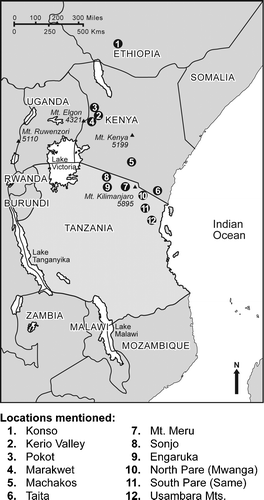
Water control on the slopes of Mt. Kilimanjaro can be described as a part of a complex, the ‘East African hill furrow’, which is found in locations along the rift valley systems. Adams (Citation1988) identified three main clusters of indigenous hill furrow irrigation: Kerio Valley in Kenya, Sonjo with Engaruka and Pagasi (c.40 km to the north of Sonjo), and Kilimanjaro. Today, the highest density of schemes is found in the ‘Kilimanjaro cluster’, which includes the highland areas of Machakos, Taveta and Taita in Kenya, the slopes of Mt. Meru, the Pare Mountains, and the Usambaras. There has been further research in the past two decades into indigenous land and water resources management in sub-Saharan Africa, especially into indigenous irrigation systems and water harvesting (Adams & Watson Citation2003). Descriptions of irrigation in the Kilimanjaro cluster have been made by Grove (Citation1993), Holand (Citation1996), Mosgrove (Citation1998), Gillingham (Citation1999), Tagseth (Citation2002), and Devenne (Citation2006) for Mt. Kilimanjaro, Beez (Citation2005) for the Kilimanjaro lowlands, Fleurét (Citation1985) for the Taita hills, Mascarenhas et al. (Citation1985) and Hakansson (Citation1995) for the South Pare Mountains, and Sheridan (Citation2002) for the North Pare Mountains.
Widgren (Citation2004) has questioned why some areas have continued to sustain high numbers of people pursuing intensive agriculture, and has sought to explain the location and development of ‘islands of intensive farming’. Östberg (Citation2004) discussed the emergence and expansion of hill furrows at Marakwet, Kenya, in relation to several explanations distilled from the literature. The first of these explanations is based on evolution, where society progresses from less advanced to more advanced stages. The second explanation is based on population growth, including the Boserupian explanation whereby population growth forces agricultural intensification (Boserup Citation1965). The third explanation relates to markets and exchange, where intensification or growth in irrigation is related to exchange with groups pursuing pastoralist or other alternative livelihood strategies, or to the provisioning of the caravan trade. The fourth is political centralisation, including Wittfogel's (Citation1957) thesis that the development of hydraulic control presupposes political centralisation. The fifth explanation is politics and the hypothesis of siege, which presupposes that intensification relates to localised high population densities that have developed out of security needs. Sixth are explanations based on ethnicity, which include the discredited notion that ‘more advanced’ people had introduced the technology in the past. Östberg argues against single-factor explanations. Adams (Citation1989) questioned whether indigenous irrigation should necessarily be seen primarily as an intensive form of agriculture, or whether it could be explained in terms of adaptation to localised resources or in terms of risk management. Sutton (Citation1984) suggests that some of the claimed instances of intensive agricultural systems are better understood as specialised.
Increasingly, it is acknowledged that claims about changes in resource use or the environment need to be grounded in empirical and diachronic studies of such changes (Niemeijer Citation1996). This basic notion and associated methodological innovations underlie studies which challenge established ideas about processes and directions of environmental change in Africa (Tiffen et al. Citation1994; Fairhead & Leach Citation1996). Alternative methods are needed to investigate past use of the environment in order to assess changes in the environment and livelihoods, and to overcome the notion of a static, pre-development past. Local practices of resource use, such as farmer-managed irrigation, often remain inadequately documented, even for historical periods. The objective of this article is to explore oral history as a method to access the history of resource use, with irrigation furrows established in a phase prior to colonial impact as an example. It is argued that the history of water use can be sought in the oral history of the institutions involved in the management of the irrigation schemes. On the slopes of Mt. Kilimanjaro, in most cases this is the sedentary patrilineage or ‘clan’.
This article explores the utilisation of place- and community-specific knowledge in the reconstruction of early furrow development. Following the introduction and background to the irrigation practice, methods from research on the development of hill furrow systems in eastern Africa are reviewed. Some oral history of the irrigation, water and settlement is reviewed before the case study of irrigation in an upland settlement in Mt. Kilimanjaro is presented.
Historical background
The irrigation tradition on the southern slopes of Mt. Kilimanjaro can be called mfongo irrigation, from the term denoting an irrigation ditch in the local vernacular (Kichagga). The mfongo technology has been described in sources starting with 19th century European travellers, who documented the technology as characteristic of resource use in locations around Mt. Kilimanjaro. Rebmann (Citation1860, 242) reported the construction of canals by the clients of mangi (Kichagga: prince, chief) Masaki and the practice of zero grazing following a visit to Kilema in 1848. More detailed incidental reports from subsequent decades show that irrigation infrastructure was developed in locations across the southern slope of Mt. Kilimanjaro (von der Decken Citation1869; Johnston Citation1886; New Citation1971 [1873]).
More detailed sources on the technology and its extent date from throughout the 20th century. The extensive hill furrow irrigation in the uplands was in conflict with the needs of European planters settling downstream on the lower slopes of Mt. Kilimanjaro from the beginning of the century. Changing colonial and post-colonial governments have aimed to bring water use in indigenous irrigation under their control since at least 1908 (Government of Tanganyika Citation1956). The record left as a result of past concerns with water management can be exploited for new purposes. In the first systematic study of indigenous irrigation in Kilimanjaro, Gutmann (Citation1926, 371) estimated that there were more than 1000 furrows on Mt. Kilimanjaro probably preceding the advent of World War I. He found 66 canals in the districts of Old Moshi and Mbokom alone (Gutmann Citation1926, 374), within an area served by 65 schemes today (Sarmett et al. Citation1997; I.J. Matcha, Regional Hydrologist-Kilimanjaro, unpublished data). Irrigation engineer Buckland (Citation1939, Citation1940) found 602 furrows in a partial survey of the southern slopes in the period 1939–1940. Water warden Pike supervised a mountain-wide survey of furrows in 1959. Pike (Citation1965) may have considered his survey number of 726 furrows (Molohan Citation1960) to be incomplete as the figure did not appear in his article, where he wrote: ‘(T)here are now so many furrows, most houses on Kilimanjaro are within a very short distance of one’ (Pike Citation1965, 96). The results suggest a decline in the furrow technology during the intervening 20-year period. The thesis of a decline in the furrow technology in the highlands received support from Burra & van den Heuvel (Citation1987), who relied on the Water Master Plan figures in estimating that the number of schemes had declined from 1000 to 500 between 1960 and 1986. A more comprehensive survey was made in the mid-1990s, when 1388 ‘traditional furrows’ were registered in the administrative Kilimanjaro Region (Pangani River Basin Water Office, unpublished data).
Data compiled on changes in water use in one catchment on the south-eastern slope of Mt. Kilimanjaro (the Himo River) in the period 1940–1992 showed a 41% decline in the number of furrows, but stability in dry season water abstraction (Tagseth Citation2002, 55). The abandonment of small furrow schemes was accompanied by an increase in the average size of the surviving schemes. The dry season throughput per scheme increased from 11 litres per second to 19 l/s during the same time period. Schemes in this area were established during different periods in different altitude zones on the slope (Tagseth Citation2002, 62; J.M. Kobalyenda, Principal Water Officer, unpublished data). The available information documents the early development of a substantial infrastructure of water conveyance, and relative stability in the abstraction of water throughout the 20th century. Hidden behind this stability lie important changes, such as a declining reliance on furrows in the old irrigation districts upslope and the development of new schemes and uses of irrigation in other areas, primarily downstream (Tagseth Citation2006, 496). Devenne (Citation2006) mapped the development of schemes in Mbokom at Kilimanjaro from aerial photos in combination with interview data. He indicated that the existing nine schemes were all present in the 19th century, and that while canals have been extended, no schemes have been added or abandoned in the area. While the utility of recreational GPS for detailed mapping was limited by selective availability in the 1990s, the current accuracy permits mapping at the scale of c.1:50,000. This has been exploited by M.I.J. Davies (unpublished data), who has mapped and classified the infrastructure in an area in Pokot (Kenya) as belonging to broad time periods on the basis of interview data. In this way he was able to show a dynamic where new schemes were added in an upslope expansion of the system, while some of the old infrastructure was abandoned. In the present study registration of scheme layout and the irrigation network are limited to participatory sketch mapping and the recording of sequences of schemes belonging to the left and right banks of streams.
A methodological review
Masao (Citation1974), an archaeologist from Kilimanjaro, raised the issue of the antiquity and the dating of furrow irrigation in an article in Tanzania Notes and Records intended to provoke further research on the issue. He complained that mention of the mfongo system in the literature was usually brief and often inaccurate. Masao has provided original contributions to the ethnography of irrigation and oral traditions in the landscape of Uru, but he relies heavily on Kathleen Stahl's (Citation1964) political history of Kilimanjaro. Masao (Citation1974) found that the technology of the mfongo water furrows and the nduwa (collection ponds used for short-term water storage) is as old as the Chagga people. This resonates well with current oral traditions, which claim that irrigation has been practised since ‘time immemorial’. Masao correlated the history of irrigation with the history of settlement. Mangi Marealle's (Citation1952) assessment that the Chagga settlement is as young as 300–400 years was accepted. However, this dating, which is based on the history of the royal family, is contradicted by other sources available to Masao (e.g. Stahl Citation1964), and by archaeological findings which identify Marealle's home village as an Early Iron Age agricultural site (Odner Citation1971) which had previously been identified as an old habitation site through oral tradition (Schanz Citation1913). The archaeology strengthens oral history claims that the area was settled by other lineages prior to the advent of the ancestors of the Marealle from Ukamba. The implied thesis of a relationship between settlement and canal development is an interesting issue, but it should be substantiated. In this section, I will review some methods for dating furrow schemes.
In his analysis, Masao (Citation1974) introduced two methods for dating. The first relies on the history of settlement to establish the date of furrow construction. It also suggests reliance on the naming of schemes to explain how and why a place was settled. The Masale furrow in Mbokom is a comparatively large scheme which carries 60 l/s (Pangani Basin Water Office, unpublished data). It was identified as one of the oldest furrows by Masao (Citation1974) on the basis of its unusual name, which does not derive from a person. The name refers to masale plants (Kichagga: dracaena ssp.), which are present along the head reaches of the furrow (personal observation, November 2002). The masale are symbolically important and sacred. Uprooting them without due precaution is understood as dangerous. The plant can serve as a cultural marker because of its use on grave sites and boundaries, where it often remains. Etymologically, the Masale furrow could thus be taken to be the ‘furrow of peace’, or ‘the ancestral furrow’. In this case, however, the inference from the name is in conflict with the local explanation. The name was said to derive from masale plants claimed to be growing wild at the furrow (interview November 2002, in Mbokom, Moshi Rural District). The proposition is methodologically interesting; place names have been exploited more systematically as a source for identifying prehistoric settlements in other places. Other place names which might refer to irrigation could be investigated; for example, Nduweni and Ndiveni (in Marangu, Moshi Rural District and Lembeni, Mwanga District respectively) refer to ponds which could be artificial. Furrows at Sasseni (literally ‘at the furrows’) in Same district are documented from a place name in the 19th century (Baumann Citation1891).
The second method involves dating from oral tradition by correlating the initiation of furrows with the better-known succession of ‘chiefs’ and from major contemporaneous events. In doing this, Masao relied on the record of political history, the chiefs and heroes of the past, which was Stahl's (Citation1964) main concern. In this way, the initiation of the Teshena furrow in Mbokom, ascribed to the agency of a Mrecha clansman, could be dated to the period 1830–1845, when Masha Mrema became the first ruler of Mbokom. However, by that time members of the same family, in the same district, already controlled the Mrambo furrow. This older furrow situated next to the Masale furrow could not be dated with this methodology, as there was no record of ‘chiefs’ to compare with. The Mrambo furrow, possibly initiated before the 19th century, still serves the Korini area in Mbokom (personal observation, November 2002), and it carries 30 l/s from the Mrusunga River (Pangani Basin Water Office, unpublished data).
Thus, one limitation of the method suggested by Masao is that it is of limited use for periods preceding political centralisation. Another problem is the reliance on a link between furrow creation and chieftaincy, which is weaker than historians from the period of indirect rule tended to assume (Dundas Citation1924; Stahl Citation1964). Masao's observation that the establishment of furrows in Mbokom district preceded the advent of the chiefs there is supported by similar stories, for instance the tradition on the advent of the ancestor of the chiefly lineage of the Marangu district (Schanz Citation1913; N. Mtui, unpublished data).Footnote1 The reliance of irrigation on political centralisation has also been denied for other clusters of early irrigation, in the Pare Mountains (Kimambo Citation1996), the Usambara Mountains (Feierman Citation1990), and in the nearby Taita hills in Kenya (Fleurét Citation1985). Throughout this area, irrigation development depended on a more basic unit of social organisation, the sedentary patrilineage. Communities along the Rift Valley with less political centralisation have also been able to develop irrigation traditions (Östberg Citation2004).
The hill furrow technology of highland peoples in north-eastern Tanzania is not altogether dissimilar to the irrigation technology known from places along the Rift Valley, for instance, Konso, Marakwet, Engaruka, and Sonjo. Soper (Citation1983), who surveyed the irrigation systems of the Marakwet, Kenya, was also interested in dating the systems. Here, the organisation of irrigation depends on the age set. In age-set systems, young people (men) are grouped together into a named corporate unit. As they become older they remain together in the same group, and rise together in seniority within a hierarchy of such sets (Keesing Citation1981, 275). The dating of construction through correlation with the social organisation in age sets appeared to be a sensible proposition, but it failed because informants could not provide the necessary supporting data. Soper (Citation1983, 78) was disappointed that ‘(h)istorical traditions among the Marakwet appear to be poorly developed, or at least have not been collected and studied to give any sort of coherent picture’. There were inconsistencies or lack of agreement even in the naming of the schemes. However, it was consistently claimed in oral tradition that the first furrows were already existing when the forefathers of the Marakwet arrived from the north and met signs of old occupation and one old man living high up on the escarpment.
Soper's second proposition was to use radiocarbon dating. This seemed initially tenable, since Marakwet people tend to use a lot of wood in their furrow construction. However, the prospects for dating the canals directly by archaeological means were judged as poor, ‘given the constant maintenance and replacement of wooden structural components which might be dated by the radiocarbon method’ (Soper Citation1983, 78). Direct dating of an irrigation system, for instance through analysis of charcoal found in deposits (Francaviglia Citation2000), has since been achieved elsewhere, and should be possible in eastern Africa through specialised archaeological methods. Further knowledge is likely to follow when archaeological excavations in the areas with long established and active traditions of irrigation commence (D. Stump, personal communication 2007). Radiocarbon dating of forest glades (Pomel Citation1999) shows that anthropogenic change in the environment has a history of 5000 years on the higher slopes of Mt. Kilimanjaro. Odner (Citation1971) identified evidence of Iron Age Bantu agriculturalists from the late first and early second millennium AD from charcoal found in association with pottery. However, there would be problems of validity in applying indirect indicators from settlements or fields to the history of irrigation at Mt. Kilimanjaro. Another possibility mentioned by Soper (Citation1983) was to rely on core samples from the sycamore fig trees along the canals as sources of carbon for analysis, on the assumption that these could not have established themselves prior to the construction of the canal because they depend on seepage from it. The main problem appears to be the decomposition of the trees’ cores and the number of samples needed in order to establish the oldest tree. Vegetation influenced by seepage from an irrigation system is common in other locations. Dendrochronology in eastern Africa has advanced over the past decades (Martin & Moss Citation1997; Maingi Citation2006). The sycamore fig has been judged a poor candidate (Maingi Citation2006), and inferences from the number of rings observed on the stump of an old fig on top of an irrigation structure would be unreliable (personal observation, Ugweno Division, Mwanga District, 2003). Tree rings can serve as proxies for precipitation because moisture is the main restriction on growth (Therell et al. Citation2006). In the Mediterranean region it has been shown that remains of olive trees hold a record of the effects of past irrigation (Terral & Durand Citation2006). It is possible that seepage from a canal has effects on tree growth which can be analysed, but the use of vegetation as an indicator remains unexplored.
Soper had more faith in his third proposition, which was to rely on the stratigraphy of the network of canals to establish the succession of establishment. Thus, ‘in the Embobobut system a relative sequence of construction can be postulated on the basis of superposition, on the assumption that where furrows cross, the upper one was built later’ (Soper Citation1983, 78). The main problem with this methodology for establishing a sequence of construction is that it depends on the use of aqueducts, which is less common in other furrow systems. In some cases, for instance where a more recent furrow has cut off an older furrow, it is possible to make inferences about sequence from the morphology of the canal network. Through excavations at the abandoned Late Iron Age site at Engaruka, Stump (Citation2006) has shown that processes and sequences in the development of the system of terraced fields and furrows can be defined by examining the stratigraphy of the site through excavation. The mfongo canal schemes are seldom built once and for all, and it may be difficult to find carbon for dating since there is little use of wood in the construction of canals in Kilimanjaro. Wood was used in the past for the ilalo (Kichagga: aqueduct), but this construction method was not widely used. Wooden pegs were used in the initial constructions of canals, but these may not have been durable. Wooden boards are used in the outlet of the collection ponds, but these are periodically replaced (personal observation of the construction of canals and the reconstruction of a collection pond in Ugweno and Lembeni Divisions, Mwanga District, 2002). Collection ponds (Kichagga: nduwa; Kigweno & Chasu: ndiva) for short-term storage of furrow water or spring discharge are not as common on the slopes of Mt. Kilimanjaro as they are in the Pare Mountains, and there appears to have been a decline in their use. Some ndiva in Ugweno in the North Pare Mountains have large fig trees standing on the very crest of the dam. These indicate old age and could be subject to further analysis. An important institution in the management of irrigation was the meeting that followed completion of maintenance work. At least from the late 19th century onwards, the work party would meet at a certain dam under the shade of a fig tree and drink together a brew of cane juice (Chasu: dengeluo) fermented in a pot rested between its roots when the distribution of water was to be agreed upon and libations offered to ensure success in irrigation. While an old fig straddling the crest of a dam can serve as evidence based on stratigraphic principles, it can also feature in oral history because of institutions associated with it (fieldwork, Ugweno Division, Mwanga District 2003).
In approaching the problem of irrigation history, my training directed me towards the use of the interview, in combination with observation and the landscape. My methodological proposition, generalised from suggestions by Masao (Citation1974) and Soper (Citation1983), is that dates and sequences in resource management can be found through correlation with central social institutions involved in the phenomenon. This type of oral history depends on the identification of people with specialist knowledge, and of the relevant institutions. A central objective is to find a sufficient density of sources to make it possible to compare them. Stahl (Citation1964) and Masao (Citation1974) correlated canal construction with the succession of wamangi (Kichagga: princes, chiefs), since these were taken to be important agents. Soper (Citation1983) attempted to correlate furrow establishment with the age set mobilised in the construction effort. In the highlands of Kilimanjaro Region, irrigation management has usually depended on groups defined by kinship and residence. A promising option which has not yet been fully explored is to rely on the close relationship that informants have to their home area and to their family, and on the specialist knowledge of the furrow elders and their families. For the study area, my proposition is to rely on the history of sedentary patrilineages which have an acknowledged relationship to specific mfongo canals and ndiva ponds. This method permits the establishment of dates or sequences through genealogical dating, and yields data for the reconstruction of place- and group-specific environmental history.
There are several difficulties in the use of the oral history of resource use. It is generally acknowledged that oral history in relation to contested resources such as land and water is influenced by discursive strategies (Fortmann Citation1995). This can partially be accounted for by seeking to understand conflicts within the community and between the community and outside actors, which requires fieldwork (Fairhead & Leach Citation1996). In the case of an irrigation furrow in lower Marangu, the leaders elected by members of an upstream village were challenged by the heir of the scheme who claimed that the furrow could not work well because it had been taken from his father without compensation, and was affected by a conditional curse which had to be lifted. A response from those leaders was to claim that the scheme was not the same following realignment during rehabilitation. In my presence, as a student from Europe who might have contacts interested in sponsoring further rehabilitation, they argued that such claims and problems were now void. Walking with other informants, I was not able to identify the old alignment in the field. The story of the realignment could thus be interpreted as a mythical construct, or alternatively as one of several histories of a contested scheme. In addition to seeking out different sides of the story, it is possible to add cases where conflicts are different, or to use historical material as a control for the effect of current struggles over resources. Lawi (Citation2003) has argued that oral traditions should be used in combination with other sources. While historical sources on local level resource use can be scarce or imprecise, even for recent periods, the landscape can act as a control. Method triangulation can be achieved by investigating more cases, recruiting informants in different positions, or by drawing on other studies. Feedback from national and global environmental discourse and a desire to please (Fairhead & Leach Citation1996, 72–73) and the objective of claiming good ecological stewardship to outsiders (Fortmann Citation1995) can lead to problems of acquiescence in the oral history of resource use. This can be countered through extended fieldwork and building relationships. Börjeson (Citation2004) was able to reinterpret changes in agriculture in Mbulu on the basis of detailed mapping combined with interviews undertaken in the actual fields, among other methods. I argue that oral histories specific to locations (fields, irrigation schemes) and actors are more reliable than statements on general conditions. The present study pursues the history of water use in the biographies of specific schemes and groups of people.
Early irrigation development in the light of oral history
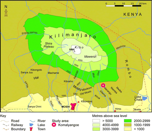
The analysis of interviews with scheme managers on the establishment and management of 16 furrows along a transect across the slope of Mt. Kilimanjaro at Himo-Marangu () indicates that schemes have been established during different periods on different sections of the slope (agro-ecological zones). Factors such as scale and the date of scheme establishment are influential in current irrigation organisation, which can be classified into three main types. A first type of irrigation management has no named irrigation union. Management relies on direct negotiation between members of the group of furrow users, under the authority of a furrow elder. A second main type is described as formal. It has a named group of users, elected leadership, and integration with the village government is common. In addition to these, a few large schemes were under the jurisdiction of chiefs. The abandoned, long furrow of blood (Kichagga: mfongo o samu), named after violent clashes over water between users from Marangu and neighbouring Mamba in the first 30 years or so of the 20th century, is one example. Another example is the pre-colonial (Lent Citation1896) Ufongo lo Mwika, a large multipurpose water delivery system for the Mwika district, which was abandoned in the 1950s after a pipe scheme was constructed. Most of the large schemes under the jurisdiction of the chiefs were abandoned in the 20th century.
Fig. 2. Mt. Kilimanjaro and the location of the case study area.
At a very general level, it appears reasonable to assume early settlement of some prime locations. It is possible to identify some of these locations from oral traditions and through their place names. Settlements are often named after early settlers and sometimes by ecological characteristics. Hypotheses of early settlement could be developed on the basis of traditions of settlement, and the analysis of landscape elements such as the location of shrines, old markets, political centres, roads, place names, and patrilineage clusters. Moore (Citation1986) suggests that new settlements could have been added first in a process of lateral expansion preceding upwards expansion. The settlement of the lower slope appears to be more recent. Regional processes of development, settlement and intensification in different sections of the slope are interrelated with the dynamics of furrow development. The period of scheme establishment correlates with irrigation organisation, and there is systematic variation along the slope.
Irrigation is integrated with culture and social organisation. It is rich in meaning, and idioms are taken from this realm in order to explain other facts of life. The furrow is a source of fertility. In North Pare, it has been shown that the irrigation scheme is associated with a gendered symbolism (Sheridan Citation2002). At Mt. Kilimanjaro, a similar symbolism is seen in prohibitions on female participation in matters of the furrow, and in the past practice when pregnant women did not cross furrows. Rainmaking was a source of political power in the 18th and 19th century, when such abilities could bring a mangi to power (N. Mtui, unpublished data). The political significance of rainmaking is more fully researched for the Shambaa people at Usambara Mts. (Feierman Citation1990), one of the sources of migrants to Mt. Kilimanjaro. Irrigation at Mt. Kilimanjaro has been secularised, but the authority of a furrow elder is still enforced by his ritual power and his relationship to the founder of the furrow. Furrow rites may have become less common and more discrete, but few furrow elders declared that they intended to discontinue libations for the furrow: ‘My father was the last to sacrifice. I am responsible for doing it, but I have not done it yet... I must perform a sacrifice at the intake because the ancestors were able to get water from that intake. It is thanking God for giving us blessings.’ (informant H, furrow chairman).
A tradition in Old Moshi attributes the start of irrigated grain cultivation there to a curse in c.1850 that mangi Salia would die before the harvest of finger millet. Salia tried to delay the sowing, but since he was blown up along with 39 others while drying his gunpowder, millet has been cultivated in the dry season when irrigation is required (Dundas Citation1924, 54–55). In Mbokom (fieldwork June 2002) (Masao Citation1974) and in Uru (I.S. Holand, personal communication 1997) there are traditions that the furrow surveyors were guided by red ants on the march. However, there is no commonly told story of an original adoption of the irrigation technology. This could be taken as an indication of an incremental development of irrigation from modest beginnings in a distant past. However, seemingly incidental information on furrows is not uncommon in oral traditions. A local historian, Nathanial Mtui (unpublished data), recorded the legend of the arrival of the chiefly lineage in Marangu in a manuscript that was utilised by Stahl (Citation1964). This document suggests that the Mboro family in the vicinity of the chief's place had autochthon rights (i.e. as originators) to their irrigation furrows, since these were established before mangi Lyimo arrived and established his chiefdom. This family no longer lives in the area (fieldwork November 2002). Likewise, it is mentioned that the son of mangi Lyimo was tricked to come to a furrow intake from the river Moonjo close to the Manyangwe stream in Marangu and killed there (N. Mtui, unpublished data1). The version of this tradition reported by Schanz (Citation1913) mentions two centres in modern Marangu which were conquered by mangi Lyimo, not far from sites identified in Odner's (Citation1971) archaeological survey (the Marangu market site is broadly associated with a western centre and the Marangu TTC site is broadly associated with an eastern centre where the primary court is still located). A third site mentioned by Mtui (N. Mtui, unpublished data) is Fumwu Lya Meku (ancestor hill), a hilltop above the forest, which was the first base of Marealle's ancestors when they arrived from Kamba, and which is now a grave site and a shrine. If this legend could be relied upon as fact, a record would exist of several furrows in the central banana belt, established five or six generations before 1800. However, it is difficult to ascertain whether incidental information or the historical figure has been added to a core myth. Death or disappearance at a water source is a recurrent theme in the local lore of water in Moshi, Ugweno and Meru. This lore is involved in the definition of relationships between land and water resources and groups of people, and in the definition of political domains.
It can been argued that the link, both in fact and in memory, between farming and the politics of the chiefs is weak, and that early furrow development in some locations preceded the centralisation into proto-states. Moore (Citation1986) has drawn attention to the neighbourhood and the patrilineage with its land (ukoo) as basic and resilient institutions in Chagga society. My proposition is to use the stability of these communities, and to develop methods to solicit community members’ knowledge of their own home area, their families, and of the past micro-politics of survival. Information about the establishment of early furrows has to be sought for specific schemes, groups of people and areas, primarily among elders within the resident family branches descended from the furrow initiators.
The Chagga of Kilimanjaro are virilocal, and their settlements have developed into sedentary patrilineages (ukoo) which hold a common interest in land and other resources. The ideas of the ancestor cult are intertwined with the local discourse on rights in resources, and were subordinated and transformed rather than thrown out with the near universal adoption of Christianity. The virilocal pattern of residence and the tight bonds between people and their ancestral land make it possible to access location-specific oral history of considerable depth, namely the traditions of the area. Information on genealogy and settlement is remembered because it can be used in local struggles over resources such as water, but also because it may be needed in the explanation and remedy of misfortune and in the observance of avoidances. The initiator of a mfongo canal establishes management rights over a scheme, and the scheme is usually named after him (but schemes are often known as the furrow of a past furrow manager, not of the initiator). His patrilineal descendants have the right to appoint the new furrow elder, who usually serves for life. The authority of the furrow elder stems from his relationship to the furrow initiator. It is his obligation to call upon users of the water to carry out communal work on it. He is also the ritual head of the group of furrow users, and the one who can make offerings at the canal to ensure that the water flows smoothly when it is let in after repairs. In cases where nothing has broken the normal succession of furrow managers, elders with management rights remember stories of furrow establishment, as they are required to legitimise them.
Case study of an upland settlement
Komalyangoe village () is well established and well supplied with water. It is typical of areas where the mfongo technology is carried on under family and neighbourhood organisation. The springs, natural waterways and artificial canals are so densely located that it can be difficult to locate a spot where one cannot hear the trickle of water. It is situated in the upper part of a landscape on the south-eastern slope of Mt. Kilimanjaro named Marangu, ‘a lot of water’, describing the essential beauty that early settlers saw in this landscape. The village name may suggest that neighbouring settlements are older; the name is an ecological derivation, and describes a place where poles for construction can be collected. The local small-scale farmers recognise it as a traditional Chagga area. Such areas are distinguished by landscape features such as the dense vegetation of the small agroforestry groves, separated by hedges of masale (dracaena ssp.) and border trees. Interspersed are small open areas used for arable crops and lawns where grass is cut with sickles. The community is tightly knit along the lines of patrilineal affinity, but also by obligations of neighbourhood and friendship. The informal process of canal management relies on hereditary ‘furrow chairmen’, other local institutions and negotiations in the community of water users. Life in the core area is linked to Chagga identity, and to ideals of tradition and continuity. Access to canal water is part of all this, as expressed in the common blessing, ‘may you sleep beneath a furrow’ (Kichagga: ‘Laa sera mfongo’), which is still used.
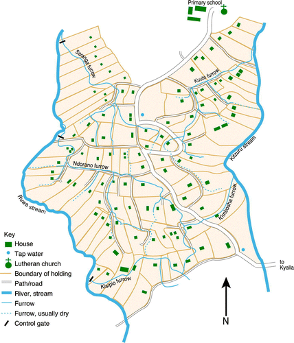
There are two sources of furrow water: the Ruwa stream and its tributary, Kizuru stream. Both are spring fed, and they supply 36 individually named furrows. Of these schemes, 17 convey water to different sections of Komalyangoe village (personal observation October 1995, and executive officer of Komalyangoe village A. Minja, personal communication 1995). The canal network is extensive, and it has a high degree of connectivity (). There are c.30 households for each furrow scheme in the village, as compared to 50 households for each public standpipe. The schemes are generally small, with actual discharges ranging from 8 l/s to 42 l/s (M. Temu, water technician, personal communication 1996). The furrows and the locally acknowledged leaders were identified while walking with staff from Marangu West Ward. The furrow chairmen of four schemes and some other elders were recruited as informants and interviewed in several sessions. Relevant data and quotes from interviews with members of 65 households in the same area are also used in the analysis. The informants’ identities remain anonymous in accordance with the provisions agreed upon with them, and instead they are represented by a capital letter.
Fig. 3. The canal network of Komalyangoe, Marangu (schematic).
First, I will describe some technical aspects of water control. Water is abstracted either from streams or springs, or sometimes from both. The stream water is checked by a small permeable dam, or by a stone wall which protrudes into the streambed, in order to create a hydraulic head. Dams are constructed with boulders, stones, twigs, and mud. Intake structures are often located at a point where the water flows more smoothly, such as at a pond, or where the stream divides naturally. Permeable structures and overflow structures are useful, as the stream flow is variable. Both large flow in the rainy season and low flow are problematic. It is necessary to repair or modify the check structures from time to time, after heavy rains, or when the flow is small. Evidently, quite often the furrow takes most of the available water during the dry parts of the year, yet some water is always available for the next furrow below. This is due, first, to the loss or return of water to the stream close to the abstraction point and, second, to the augmentation of stream flow through spring recharge along the stream (groundwater seeps out within the stream valleys). The stream diversion technology also makes it technically difficult capture all the water at a single abstraction point.
If a furrow threatens to overflow during heavy rains, the canal bank is cut at a point close to the stream in order to avoid damage. Within the river valley, the water is carried on a gentle gradient in a canal running on an embankment, in places several metres high, towards the settlement and farms on the ridge. Seepage is exploited for sugar cane, taro (cocoyam), and watercress.
Regular abstraction points in the earth banks of the canal can be seen from the small packs of grass and mud used to block them. These can be seen first above the terraced plots for seasonal crops in the river valley and then above the first vihamba (agroforestry groves). A furrow usually divides upon reaching the main settlement on the ridge. The proportional weir is used to divide permanently flowing water into secondary canals. It is possible to adjust the distribution of water here by placing and adjusting a small pack of mud, twigs and grass on either branch. The canals divide to provide running water close to most homesteads and fields. Other secondary canals are dry. The terrain on the ridge is sloping, and it is sometimes necessary to bring the water down rapidly. A simple drop structure is used to release the potential energy of the water in a controlled manner. This structure also makes a convenient tapping place for domestic water. Stone lining to prevent scouring was also observed as an alternative solution for energy control.
The horizontal footpaths tend to run alongside the canals in the river valleys and on the ridge. As the furrows tend to run more or less along the contours, they are also convenient routes for walking. The co-localisation of paths and canals has the advantage of facilitating the monitoring of the canal and the flow of water. Most turning points are situated on a public path, which also facilitates monitoring. Vertical paths have to be taken across the furrows. Solutions to furrow crossing vary in sophistication, from miniature ‘Roman arch’ bridges and stone culverts, to stone reinforcement of the banks, or simply a log thrown across the ditch. There is little need for structures to drain irrigation water on the sloping and naturally well-drained terrain. The control of runoff during heavy rains is a more important issue. Surface water is drained into the river through the irrigation canals and separate drainage canals.
The establishment of the furrows
At micro-scale the establishment of the furrows is linked to the cultivation and settlement of specific areas. The naming of places and furrows can be important. Places are usually named after early settlers and their patrilineages, or after natural features. The lower hamlet of Kisu may be the oldest settlement within the village, and it could have originated as an extension of the village below, Kyala. The hamlet name means ‘the knife’, and could be related to a ritual site. Such sites – for instance the site with an engraved stone used in the past for initiation of youths into adulthood in Kyala, as described by Fosbrooke & Marealle (Citation1952) – can confirm that an area is a long-established cultural landscape. The stone has c.20 engraved lines, each being the record of one of the ceremonies which reportedly had been held every 3–7 years until the practice was discontinued in c.1900 (personal observation and interview October 2006). The upper area of Komalyangoe village and a section of the adjacent forest reserve were covered in open bush, while the lower section was cultivated at the time of colonial impact according to Meyer's (1890) map.
All furrows in Komalyangoe village were found to be well established, and no new furrow had been cut since the development of the upper section of the village in the 1920s. This is perhaps due to changes in the social and agricultural systems, making furrow construction more difficult or less important. The construction of furrows is remembered as a co-operative undertaking. According to the elders, the economy in the peasant communities has become more individualised since the time of construction, and the creation of a new scheme would have to rely on new arrangements for labour mobilisation. The furrow elders maintained that ‘all the water is taken’, the water supply would not be able to sustain more furrows, and also that the best sites have been developed. The pattern of abstractions is thus stable. Since one of the reasons given is that the water has been taken, it is possible to argue that a principle of prescription or usufruct is in operation. According to the principle of prescription, those who made the first abstractions established the strongest claim to water, while usufruct rights are based on long undisturbed use.
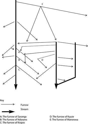
Even though ‘no one would remember how to survey a furrow today’ (informant B), the existing schemes continue to be maintained and used. This applies to all 17 furrows within the village, and generally for the area between Ona and Moonjo Rivers in the western uplands of Marangu, in contrast to the eastern and more central sections along the hard surface road where furrow abandonment appears to have been more widespread. Marorowa's furrow (located 2.5 km to the north of Kisu Hamlet and indicated as E in ) appears to be a downscaled remnant of the larger mangi furrow. The embankments of abandoned furrows can remain visible for some time, as lines along the contour within the river valleys. An investigation was focused on furrows controlled by two families in one hamlet. The O family initiated and controlled Kuute's furrow, while members of the N family were said to ‘own’ three adjacent furrows ( and ). The case history of the development of the three schemes controlled by the ‘N's’, presented in the following, builds on a series of interviews with the three furrow chairmen (informants D, E and F) and other elders.
Fig. 4. The Kisu area, Komalyangoe village (sketch map 1996, not to scale).
The Kuute's furrow, also known as Ndekylio's furrow, taps the source area of Kizuru spring. The original simple structure was made with digging sticks. It was expanded from a modest beginning to include more farms, and improved by members of subsequent generations. The objective of the construction was to provide water to irrigate the groves and the millet fields, for mole rat control and for household use. The leadership of the furrow has been handed down from father to son within the ‘O lineage’ since the furrow's construction. In oral tradition, it is held that a child and later a man were killed at the source area. The spring area is respected as a sacred place (informants H and P). At construction, and also in times of crisis, a goat or a bull used to be sacrificed in order to make the water flow smoothly (informants B and G). In the former case, the sacrifice was made to the supreme god (Ruwa), and in the latter case to ancestors. The furrow chairman reported that he offered libations of milk and the local brew mbege (made of finger millet and banana) for the same purpose. Ritual practice in connection with the furrows appears to have declined. Members of the clan controlling the furrow of Kuute also used to take part in rain rites at Fumvu lya Mku (ancestor hill) above Marangu. In times of famine and drought, ‘they went to the Fumwu lya Mku hill above and slaughtered a bull and a male goat. It used to start raining the same day’ (informant M).
The furrow of Kuute was initiated by a man named Ndekylio, who belonged to a family which clusters in the higher areas of the village. Ndekylio was claimed to have been a contemporary of mangi Kwembere, who ruled the area during the civil wars some time before Ndalio rose to power over Marangu in the 1840s. If construction preceded mangi Ndalio, dating from Stahl's (Citation1964, 318) political history suggests a date prior to the 1840s. Ndekylio was the great grandfather of the ageing furrow chairman; his father and grandfather were furrow elders before him. The chairman (informant G) believed that he was born in c.1920. As the last born son of the third wife of Marorowa, he inherited his mother's farm and his father's headquarters. Still, the chairman claimed to be the fourth furrow elder. A reliance on the family history would push the date forward towards the mid-19th century, assuming a generation span of 30 years. The best estimate appears to be a date in the 1830s. In this case, data does not permit comparison between different informants within one family, so the best option is to correlate family history with contemporary events.
In the second example, three schemes initiated by members of the same family group can be correlated, thus permitting a greater density and reliability. A genealogy of the N lineage, with key roles in canal leadership is shown in . The furrow of Ndorano was the first of a series of small furrows built by the members of this family as they grew in numbers. The original settler (1) came to settle here from an unknown place due to conflicts over pasture between two clans there. His son (2) initiated the first furrow. Today, it is called Ndorano's furrow, after a former furrow chairman: ‘The name changes for each generation, it is the grandfather's furrow’, the current furrow chairman explained. According to the chairman, the furrow was constructed ‘because it was too far to go to the river to fetch water for irrigation and domestic purposes’ (informant E). The initiator of the furrow had four sons. The resident lineage continued through two of them, (3) and (6). The last born son (6) took over his father's homestead, while his older brother (3) had other plots in the area. The son (7) of the latter (3) built the second furrow in order to provide water for irrigation of finger millet, maize, beans, and bananas in an area above the original furrow, and set up a homestead there. It was also used for domestic purposes and fire protection. This second furrow is called Saranga's furrow after a former chairman. According to the current chairman (informant D), ‘There was no involvement from the mangi. The people of the area used to organise themselves to do it. All the people who were going to use the water took part’. The son (10) of the mentioned last born (6) constructed the third and last furrow. This small scheme is usually referred to as Kisipio. The scheme improved the water supply to the former tail-end users of the first furrow, as new farms were established. According to the current furrow chairman (informant E), the great grandson of the furrow initiator, it was constructed for the ‘irrigation of finger millet. There is too little land for that now. We mainly irrigate vegetables and beans’. The detailed genealogy shows that the establishment of the schemes was related to the expansion of the resident lineage, and to the increase in cultivated acreage which took place before the process of subdivision into increasingly small adjoining compound farms. The lineage still has common slaughter parties (sacrifices), but it is developing towards three segments, each controlling its own furrow. Control over the furrow has been inherited by direct descendants of the canal founders, despite the inclusion of non-kin in the group of users. The close correspondence between position in kin groups and management rights does not imply a close relationship between family allegiance and water use for irrigation (Tagseth Citation2000, 115–120).
Fig. 5. The N lineage and key events in canal development.
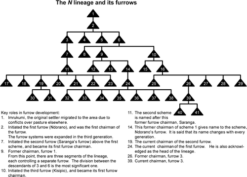
Thus, furrow construction is said to have started with the son of the original settler, the great-great-grandfather of the oldest generation alive in 1995. Relying on genealogical data, counting back 30 years for each generation, he could have been born in c.1800, and he could have established his own farm in c.1830. The next two furrows were made by grandfathers of the oldest people alive in 1895, towards the end of the 19th century.
At the time when the first furrow schemes were constructed in the area, Kisu appears to have been on the upper fringe of the settlement (c.1670 m a.s.l.). The last furrow constructed in the village starts above the boundary of the forest reserve, at c.2000 m a.s.l. (Scheme E, ). The construction of the last furrow was undertaken when the upper sections of the village were opened up for settlement in the 1920s. By that time, all existing intakes and main canals had been established, but quite a lot of modifications have been made since. Upwards expansion is controlled by a forest reserve (the ‘Half Mile Strip’). Abandoned terraces (fieldwork July 2002) and Meyer's (Citation1890; Citation1900) description of the area as open bush in the 1880s suggests earlier cultivation or other use.
Furrow establishment is linked to the expansion of the settlement and the subdivision of land for new homesteads. In the case of the N's, the first scheme was developed within one generation of settlement, and two subsequent schemes were added as the family grew in numbers, until three lineage segments controlled three separate schemes. It is estimated that the two oldest schemes were established in c.1830 and the two younger schemes at the end of the 19th century. Informants held that no new furrow had been dug since the 1920s, when the uppermost part of the village was settled. There is a fair degree of correlation between settlement and scheme establishment at village level. Mfongo irrigation is only one element in a complex farming system that combines a high number of elements tailored to suit conditions in this locality. The oral history of the area is also a source of information on how furrow irrigation has been used and on its role in the farm system.
The case of Komalyangoe represents a type of irrigation scheme that could have been established relatively early. However, it appears that irrigation was already a standard part of the agricultural repertoire at the time of settlement. The methodology could be tested in locations with a longer history of settlement, if these could be identified. Estimation of a date through correlation with chiefly reign according to Stahl (Citation1964), following Masao's example, was possible in one case. The regional study of irrigation identified different types of schemes. It is likely that the continuity of scheme tenure is less in the case of the larger old furrows, which may have relied on other institutions.
Concluding remarks
Methods for research on the establishment and development of hill furrows in an early phase prior to written history in north-eastern Tanzania have been discussed and developed in this article. Archaeological and conventional historical methods have been reviewed. The identification of the central institutions of resource management was found to be a key element in establishing a reliable location and group-specific oral history of resource utilisation. Methodology relying on oral history, legend and documentary sources has been tested with reference to changes in the management of specific canal systems and locations in Moshi, Kilimanjaro.
The case study documents one phase in a long history of furrow development. The results suggest that small canal schemes were established as a part of the spread of the settlement, and that it was an established technology by the first half of the 19th century. The assumption that the establishment of these four schemes in Komalyangoe in Moshi constituted the beginnings of irrigation is contradicted in the oral traditions of the district, and also by the established knowledge of irrigation in Mbokom in Moshi.
The prevalent type of irrigation organisation throughout the highlands of north-eastern Tanzania relies on a furrow elder (Kichagga: meku o mfongo). The furrow elder, the resident patrilineage (ukoo), the neighbourhood, and the group of canal users were thus identified as central and relatively stable institutions in local water management. The depth of location- and family-specific oral traditions can be considerable, due to the combination of a virilocal residence pattern, elements of ancestral cult and a continued patrilineal control over key resources (land, water, personnel). Members of family groups that had retained autochthon management rights over furrows were able to provide genealogies and data on key events and actors, so that sequence and dates in canal development could be established. It is argued that improved knowledge of past events should be sought through consulting specialist knowledge in central institutions in resource management. The resident patrilineage is a central institution involved in the management of indigenous irrigation in the highlands of north-eastern Tanzania.
The hill furrow irrigation systems in eastern Africa are important examples of early agricultural intensification and specialisation. The existence of more than 2000 stream diversion schemes make the Kilimanjaro Region in Tanzania a centre of this type of irrigation technology. Here, practices and organisational models of pre-colonial origin have provided some of the answers to the need for continued intensification in areas of high population densities. This article started with Masao's (Citation1974) question on the age of the canal systems and the problems of dating. Subsequently, Soper (Citation1983) introduced the question of sequence in canal development. Several possible approaches have been reviewed. Some of the past attempts to reconstruct early furrow development have relied on correlation with the central institutions of water control. The discovery that in many instances furrow construction was independent of the chieftaincy was an important premise, which initiated a search for other central institutions.
Acknowledgements
I acknowledge the assistance of the late Michael Minja of Marangu, who interpreted during most of the interviews from the Kichagga language and Kiswahili. Atanasio Mneney of Mamba, former administrative officer of Vunjo, gave a valuable introduction to the local history of the area and during fieldwork in 1995 allowed me to study Mneney's translation from 1959 of Mtui's unpublished manuscript written in c.1916. Principal Water Officer J.M Kobalyenda and staff provided access to their records of water rights. Pangani Basin Water Officer J. Sarmett and staff provided advice and access to their records. I.J. Matcha, Regional Hydrologist- Kilimanjaro provided access to notes and records on water use kept by his office. Comments from Professor Michael Jones and two anonymous referees have been helpful in finalising this article.
Notes
1. Local historian Nathanial Mtui wrote in c.1916 a manuscript in Old Kichagga. An annotated translation of this was made by Atanasio Mneney, Kilimanjaro-Mamba, dated 1959 (unpublished), on assignment for Kathleen Stahl.
Related Research Data
References
- Adams , W.M. 1988 . Irrigation before development: Indigenous and induced change in agricultural water management in East Africa . African Affairs , 87 : 519 – 535 .
- Adams , W.M. 1989 . Definition and development in African indigenous irrigation . Azania , 24 : 21 – 27 .
- Adams , W.M. 1992 . Wasting the Rain. Rivers, People and Planning in Africa , Minneapolis : University of Minnesota Press .
- Adams , W.M. and Watson , E. 2003 . Soil erosion, indigenous irrigation and environmental sustainability, Marakwet, Kenya . Land Degradation & Development , 14 ( 1 ) : 109 – 122 .
- Baumann , O. 1891 . Usambara und seine Nachbargebiete , Berlin : Reimer .
- Beez , J. 2005 . Die Ahnen essen keinen Reis. Vom lokalen Umgang mit einem Bewässerungsprojekt am Fuße des Kilimanjaro in Tansania . Bayreuth African Studies Working Papers No. 2 . University of Bayreuth , Bayreuth .
- Börjeson , L. 2004 . A History under Siege. Intensive Agriculture in the Mbulu Highlands, Tanzania, 19th Century to the Present , Stockholm : Acta Universitatis Stockholmiensis .
- Boserup , E. 1965 . The Conditions of Agricultural Growth: The Economics of Agrarian Change under Population Pressure , London : George Allen & Unwin .
- Buckland , L.L.R. 1939 . Water Executive Annual Report . Document in the University of Dar es Salaam East Africana collection EAF Per TP319T3A3. Government Printer, Dar es Salaam .
- Buckland , L.R.R. 1940 . Water Executive Annual Report 1940 . Document in the University of Dar es Salaam East Africana collection EAF Per TP319T3A3. Government Printer, Dar es Salaam .
- Burra , R. and van den Heuvel , K. 1987 . Traditional Irrigation in Tanzania. Vol. 1. Historical Analysis of Irrigation Tradition and Government Intervention , Dar es Salaam : SNV-TIP .
- Daluti , L.R. 1994 . Report on the Agro-socio-economic Situation in Pangani River Catchment , Moshi : United Republic of Tanzania-Zonal Irrigation Office .
- Devenne , F. 2006 . “ On the ‘mountain of waters’ the furrows are running dry: Rethinking Mount Kilimanjaro's irrigation system ” . In Kilimanjaro. Mountain, Memory, Modernity , Edited by: Bart , F. , Mbonile , M.J. and Devenne , F. 177 – 200 . Dar es Salaam : Mkuki na Nyota .
- Dundas , C. 1924 . Kilimanjaro and its People. A History of the Wachagga, Their Laws, Customs and Legends, Together with Some Account of the Highest Mountain in Africa , London : Frank Cass .
- Fairhead , J. and Leach , M. 1996 . Misreading the African Landscape. Society and Ecology in a Forest-Savanna Mosaic , Cambridge : Cambridge University Press .
- Feierman , S. 1990 . Peasant Intellectuals. Anthropology and History in Tanzania , London : University of Wisconsin Press .
- Fleurét , P. 1985 . The social organisation of water control in the Taita Hills, Kenya . American Ethnologist , 12 : 103 – 118 .
- Fortmann , L. 1995 . Talking claims: Discursive strategies in contesting property . World Development , 23 ( 6 ) : 1053 – 1063 .
- Fosbrooke , H.A. and Marealle , P.I. 1952 . The engraved rocks of Kilimanjaro: Part 1 . Man , 52 : 161 – 162 .
- Francaviglia , V.M. 2000 . Dating the ancient dam of Ma'rib (Yemen) . Journal of Archaeological Science , 27 ( 7 ) : 645 – 653 .
- Gillingham , M.E. 1999 . Gaining access to water: Formal and working rules of indigenous irrigation management on Mount Kilimanjaro, Tanzania . Natural Resources Journal. , 39 ( 3 ) : 419 – 441 .
- Government of Tanganyika . 1956 . Report of the Water Legislation Committee 1956 . Document in the University of Dar es Salaam East Africana collection: EAF pam k T164 1956. Government Printer, Dar es Salaam .
- Griffith , A.W. 1930 . Chagga Land Tenure Report . Document in the University of Dar es Salaam Hans Cory Collection EAF Cory 272. Government of Tanganyika-Moshi District, [Moshi?] .
- Grove , A. 1993 . Water use by the Chagga on Kilimanjaro . African Affairs , 92 ( 368 ) : 431 – 448 .
- Gutmann , B. 1926 . Das Recht der Dschagga. Mit einem Nachwort des Herausgebers , München : Beck .
- Hakansson , N.T. 1995 . Irrigation, population pressure, and exchange in precolonial Pare, Tanzania . Research in Economic Anthropology: A Research Annual , 16 : 297 – 323 .
- Holand , I.S. 1996 . More People, More Trees. Population Growth, the Chagga Irrigation System, and the Expansion of a Sustainable Agroforestry System on Mount Kilimanjaro . Cand. polit. thesis , Norwegian University of Science and Technology , Trondheim .
- Johnston , H.H. 1886 . The Kilima-njaro Expedition. A Record of Scientific Exploration in Eastern Equatorial Africa. And a General Description of the Natural History, Languages, and Commerce of the Kilima-njaro District , London : Kegan, Paul Trench .
- Keesing , R.M. 1981 . Cultural Anthropology. A Contemporary Perspective , Fort Worth, TX : Holt, Rinehart and Winston .
- Kimambo , I. 1996 . “ Environmental control and hunger ” . In Custodians of the Land. Ecology and Culture in the History of Tanzania , Edited by: Maddox , G. , Giblin , J. and Kimambo , I. 71 – 95 . London : James Currey .
- Lawi , Y.Q. (2003) . Potentials and challenges in using oral traditions in reconstructing environmental history of Eastern Africa . Dahlberg , A. , Trygger , S. , Holmgren , K. & Lane , P. Second PLATINA Workshop 17–19 October 2002 Usa River, Arusha, Tanzania , 28 (Working Paper from the Environment and Development Studies Unit, 46) . The University of Stockholm and the British Institute in East Africa , Stockholm .
- Lent , C. 1896 . Das Kilimandjaro Gebiet zwischen Moshi und Taweta mit der wissenschaflichen Marangu-station . Mitteilungen von Forschungsreisenden und Gelehrten aus den Deutschen Schutzgebieten , 9 : 42
- Maingi , J. 2006 . Growth rings in tree species from the Tana River floodplain, Kenya . Journal of East African Natural History , 95 ( 2 ) : 181 – 211 .
- Marealle , T.L.M. 1952 . The Wachagga of Kilimanjaro . Tanganyika Notes and Records 32 (January) , 57 – 64 .
- Martin , D. and Moss , J. 1997 . Age determination of Acacia tortilis (Forsk.) Hayne from northern Kenya . African Journal of Ecology , 35 ( 3 ) : 266 – 277 .
- Masao , F.T. 1974 . The irrigation system in Uchagga: An ethno-historical approach . Tanzania Notes and Records , 75 : 1 – 8 .
- Mascarenhas , A. , Ngana , J. and Yoshida , M. 1985 . Opportunities for Irrigation Development in Tanzania , Tokyo : Institute of Developing Economies .
- Meyer , H. 1890 . “ Originalkarte des Kilima-Ndscharo. Nach astronomischen Ortsbestimmungen, Wege-Aufnahmen und trigonometrischen Messungen des Hans Meyer, konstruiert bei B. Hassenstein. Karte II ” . In Ostafrikanische Gletscherfahrten: Forschungsreisen im Kilimandscharo-Gebiet , Leipzig : Duncker & Humblot .
- Meyer , H. 1900 . Der Kilimandjaro , Berlin : Dietrich Reimer (Ernst Vohsen) .
- Molohan , M.J.B. 1960 . Annual Reports of the Provincial Commissioners for the Year 1959. Northern Province . Document in the University of Dar es Salaam East Africana collection . Government Printer , Dar es Salaam .
- Moore , S.F. 1986 . Social Facts and Fabrications. ‘Customary’ Law on Kilimanjaro 1880–1980 , Cambridge : Cambridge University Press .
- Mosgrove , D.L. 1998 . Watering African Moons: Culture and History of Irrigation Design on Kilimanjaro and Beyond . PhD thesis , Cornell University , Ithica, NY .
- New , C. 1971 [1873] . Life, Wanderings and Labours in Eastern Africa. With an Account of the First Successful Ascent of the Equatorial Snow Mountain, Kilima Njaro and Remarks upon East African Slavery , London : Frank Cass .
- Niemeijer , D. 1996 . The dynamics of African agricultural history: Is it time for a new development paradigm? . Development and Change , 27 ( 1 ) : 87 – 110 .
- Odner , K. 1971 . A preliminary report on an archaeological survey on the slopes of Kilimanjaro . Azania , 6 : 131 – 149 .
- Östberg , W. 2004 . “ The expansion of Marakwet hill furrow irrigation in the Kerio Valley of Kenya ” . In The Islands of Intensive Agriculture in Africa: Past and Present , Edited by: Widgren , M. and Sutton , J. 19 – 48 . Nairobi : James Currey .
- Pike , A.G. 1965 . Kilimanjaro and the furrow system . Tanganyika Notes and Records , 64 : 65 – 67 .
- Pomel , S. 1999 . Soils indicators of anthropic actions on Kilimanjaro . IFRA les cahiers , 16 : 74 – 78 .
- Rebmann , J. 1860 . “ Journey to Jagga ” . In Travels, Researches, and Missionary Labours During an Eighteen Years’ Residence in Eastern Africa. Together with Journeys to Jagga, Usambara, Ukambani, Shoa, Abessinia, and Khartum; and a Coasting Voyage from Mombaz to Cape Delgado , Edited by: Krapf , D.J.L. 230 – 265 . London : Trübner .
- Sarmett , J.D. , Mvaa , A.K. , Monyo , S.E. , Kajigili , N.J. and Mushi , K.Z. 1997 . Ushirikishwaji wa wananchi katika usimamizi wa matumizi bora ya rasilimali za maji bonde la mto Pangani , Moshi : Taarifa ya rasilimali za maji wilaya za Hai, Moshi Vijijini na Moshi Mjini .
- Schanz , J. 1913 . Mitteilungen über die Besiedlung des Kilimandscharo durch die Dschagga und deren Geschichte. Baessler-Archiv . Beiträge zur Völkerkunde , 4 : 1 – 55 .
- Sheridan , M.J. 2002 . An irrigation intake is like a uterus: Culture and agriculture in precolonial North Pare, Tanzania . American Anthropologist , 104 ( 1 ) : 79 – 92 .
- Soper , R. 1983 . “ A survey of the irrigation systems of the Marakwet ” . In Kerio Valley. Past, Present, Future. Proceedings of a Seminar Held in Nairobi at the Institute of African Studies, University of Nairobi, 21–22 May 1981 , Edited by: Kipkorir , B.E. , Soper , R.C. and Ssenyonga , J.W. 75 – 95 . Nairobi : Institute of African Studies .
- Stahl , K. 1964 . History of the Chagga People of Kilimanjaro , London : Mouton & Co .
- Stump , D. 2006 . The development and expansion of the field and irrigation systems at Engaruka, Tanzania . Azania , 41 : 69 – 94 .
- Sutton , J.E.G. 1984 . Irrigation and soil conservation in African agricultural history with a reconsideration of the Inyanga terracing (Zimbabwe) and Engaruka irrigation works (Tanzania) . Journal of African History , 25 ( 1 ) : 25 – 41 .
- Tagseth , M. 2000 . Knowledge and Development in Mifongo Irrigation Systems. Three Case Studies from Mt. Kilimanjaro, Tanzania . Cand. Polit. thesis , Department of Geography, Norwegian University of Science and Technology , Trondheim .
- Tagseth , M. 2002 . “ Local practices and changes in farmer managed irrigation in the Himo catchment, Kilimanjaro ” . In Water Resources Management. The Case of Pangani River Basin – Issues and Approaches , Edited by: Ngana , J.O. 48 – 63 . Dar es Salaam : Dar es Salaam University Press .
- Tagseth , M. 2006 . The ‘mfongo’ irrigation systems on the slopes of Mt. Kilimanjaro, Tanzania . Tvedt , T. , Coopey , R. , Jakobsson , E. & Ostigaard , T. A History of Water. Vol. 1. Water Control and River Biographies , 488 – 506 . I.B Tauris , London .
- Terral , J.F. and Durand , A. 2006 . Bio-archaeological evidence of olive tree (Olea europaea L.) irrigation during the Middle Ages in southern France and north eastern Spain . Journal of Archaeological Science , 33 ( 5 ) : 718 – 724 .
- Therell , M.D. , Stahle , D.W. , Ries , L.P. and Shugart , H.H. 2006 . Tree-ring reconstructed rainfall variability in Zimbabwe . Climate Dynamics , 26 ( 7–8 ) : 677 – 685 .
- Tiffen , M. , Mortimore , M. and Gichuki , F. 1994 . More People, Less Erosion: Environmental Recovery in Kenya , Chichester : Wiley .
- United Republic of Tanzania – Ministry of Water Energy and Minerals . 1994 . Report on the Meeting on Water Utilisation and Shortage in the Pangani River Basin , Moshi : United Republic of Tanzania – Ministry of Water Energy and Minerals .
- von der Decken , C.C. 1869 . Reisen in Ost-Afrika in den Jahren 1859 bis 1865 , Leipzig : C.F. Wintersche Verlagshandlung .
- Widgren , M. 2004 . “ Towards a historical geography of intensive farming in eastern Africa ” . In Islands of Intensive Agriculture in Eastern Africa , Edited by: Widgren , M. and Sutton , J. 1 – 18 . Irthlingborough : James Currey .
- Wittfogel , C. 1957 . Oriental Despotism. A Comparative Study of Total Power , New Haven, CT : Yale University Press .