Abstract
The article reviews some learning objectives in the Norwegian core curriculum for four subjects in compulsory school education, namely science, social science, mathematics, and physical education. The subjects are examined with respect to maps, including map use, digital mapping tools, coordinate systems, and scales. Primary and lower secondary school pupils’ knowledge of maps was investigated before and after a group mapping project. Among three indicators, two showed statistically significant improvements in the pupils’ level of confidence when studying data with the aid of maps. The learning outcome is discussed in an inquiry-based and interdisciplinary pedagogical frame. In addition, the findings reveal that the four subjects have significantly different objectives and rates of progression regarding maps and map use. Based on the results of the group project, the author argues in favour of bringing the four curricula into more parallel learning curves. In order to facilitate interdisciplinary projects, he considers it would be interesting to coordinate the different subject curricula in the future, and recommends that attempts should be made to harmonise competence objectives that are part of several subjects in order to facilitate interdisciplinary projects in the next revision of the core curriculum in Norway.
Introduction
Interdisciplinary teaching has been recommended for use in Norwegian schools since the 1970s, but today relevant methods such as thematic and project work are used to a lesser extent than previously (Engelsen Citation2012), despite the fact that the current Norwegian curriculum – ‘Knowledge Promotion Reform’ (L06) (Utdanningsdirektoratet Citation2006) – contains a general section describing thematic and project work. These methods are well suited for use in combination with inquiry-based teaching across disciplines. It would therefore be of value to identify topics from various subjects that are suitable for interdisciplinary work. One such topic is the use of maps and digital mapping technology, as this is an interdisciplinary topic relevant within science, mathematics, physical education, and social sciences (including geography).
In this article I first give a brief introduction to L06 and some important assumptions that formed the basis of the plan. Then, I highlight how L06 covers relevant problems for an interdisciplinary map-related project involving science, mathematics, social studies (including geography), and physical education. Thereafter, I provide an overview of the justifications for theories of learning, underlying interdisciplinary teaching, and the different tasks assigned during the project. In order to illustrate the possibilities for and challenges arising from allowing primary and secondary school children to participate in inquiry-based schoolwork involving maps and map-related concepts and problems concerning digital map tools, I present and discuss some examples concerning the use of digital map technology with pupils from Grades 8–9. In addition, I present some results from tests designed to reveal the learning outcomes by the end of the project, and highlight some challenges regarding the use of map technology in primary and lower secondary schools.
Finally, I discuss possible changes for a future core curriculum in order to facilitate the planning and teaching involved in interdisciplinary map-related inquiry-based projects. In this respect, it is of special interest to discuss how the learning outcomes could be changed in a way that would help teachers to teach cross-subject projects. This could only be fulfilled if the revised core curriculum were in better harmony regarding which themes taught at each grade.
The Norwegian core curriculum: L06
The Norwegian curriculum L06 consists of two parts: a general part and a subject-specific plan for each school subject. The general part indicates the overall goals of primary and secondary education in Norway, and describes the value and the cultural and knowledge base of education. The subject-specific plan contains a description of the learning outcomes that pupils should have attained for each subject upon completion of Grades 2, 4, 7, and 11. The learning outcomes are concretised through a number of formulations or competencies of knowledge.
One of the intentions behind the national curriculum reform was to give teachers the freedom to choose their own teaching methods. Some restrictions from the general section about thematic and project work and some subject-specific objectives meant that some method constraints were implicit in the reform. The science curriculum includes an objective named ‘The aspiring scientist’ (Forskerspiren), whereas the geography curriculum includes ‘Geographical methods and tools’ (Geografiske metoder og verktøy). These objectives are considered essential for understanding the nature of science, science as facts, and scientific processes (Isnes Citation2005), and thereby legitimate learning outcomes that include some methodical constraints.
The L06 competence objectives may be described in terms of a hierarchical knowledge base with different verbs used to describe the rungs of a ‘ladder’ (Isnes Citation2007). The system is based on Bloom's Taxonomy – a classification of learning objectives in education (Bloom Citation1956) – whereby, as part of pupils’ knowledge of subject matter, at the lowest level a pupil is expected to be able to ‘reproduce knowledge’, a pupil of average level should be able to ‘understand and apply’, and a pupil at the highest level should be able to ‘analyse and evaluate’ (Isnes Citation2007; Mikkelsen Citation2008). This system is generally applicable for all subjects for each grade. Isnes (Citation2007) warns against ‘blind usage’ of this taxonomy and argues that instead it should be considered in relation to the degree of difficulty of the instructional content. For example, there is considerable difference between reading a newspaper and reading a map (Isnes Citation2007).
Coordinates, scales, and maps (analogue and digital) in the Norwegian core curriculum
With regard to science, social studies, mathematics, and physical education, in L06 there is a large gap between how these subjects treat map and coordinate themes. In each case, the competency objectives associated with the use of maps, coordinate systems, and mapping technology (analogue and digital) increasingly progress in relation to the pupil's age. However, there is a large gap between how the objectives are considered to be achieved, the level of detail in which they are treated, and how far up the knowledge ladder a pupil is expected to have climbed when working on these themes.
In the geography component of social studies taught in primary schools, the use of analogue and digital maps occupies a central place throughout primary school education, with most emphasis placed on reading, interpreting, and using maps, and to a lesser degree on giving pupils opportunities to produce maps on their own. By Grade 11 (age range 16–17 years), which is equivalent to Grade 1 in upper secondary school, the competency objectives include more investigative and analytical use of maps and digital mapping tools.
By contrast, in mathematics, competency objectives related to the ability to use coordinates and simple coordinate systems are introduced by Grade 4 (9–10 years), both with and without digital tools, and by Grade 7 (12–13 years) there is a more investigative objective, whereby pupils should have the ability to create maps on their own.
In physical education, there is a uniform progression throughout the entire period of primary school education regarding the use of maps, but in this case the curriculum mentions pupils’ ability to make maps on their own only after Grade 4. Digital tools are not mentioned in this connection in the physical education curriculum.
Maps and mapping are not mentioned explicitly in the science curriculum, and the subject is first included in the curriculum when pupils engage in an investigative technical approach as part of the main topic, named ‘The aspiring scientist’ (Forskerspiren). The main purpose of the topic is to teach pupils to collect, systematise, and present their own data themselves, both with and without the use of digital aids. The topic largely uses geo-referenced information connected to maps, and is therefore well suited to map-based applications within a situated context.
In comparison, the social studies curriculum seems to be more defensive with respect to setting guidelines for subject-related method approaches, and the curriculum contains few concepts associated with field excursions and investigative usage of maps. Due to governmental guidelines that promoted freedom in teaching method in the curriculum (Mikkelsen 2008), the working group involved in formulating the social studies curriculum laboured with the same problems as encountered for other subjects. In the case of science (and for geography taught in Grade 11), the situation was resolved by introducing special main topics in which important subject-specific methodological competence objectives were included as knowledge method objectives (Mikkelsen Citation2008), and the argumentation was that the topics fields and their associated objectives were fundamental to the taught subjects. In the primary and lower secondary school curricula, the special main topics for science and geography in Grade 11 were respectively ‘The aspiring scientist’ (Forskerspiren) and ‘Geographical methods and tools’ (Geografiske metoder og verktøy), as mentioned above. Both topics led to competence objectives that may potentially encourage further educational development based on a fundamental investigative approach, both for the pupils (internal) and for those that organise and manage the educational process (external). In addition to the two topics associated with inquiry-based education, Anderson (Citation2007) discusses investigative education as something distinctive of the sciences.
Selected learning outcomes in the L06 core curriculum (Utdanningsdirektoratet Citation2006) are listed in , which shows the grades in which attention is given to topics with relevance to map work, coordinate systems, and scales. also includes some learning outcomes from the science curriculum and it is clear that a number of relevant methodological competencies are included in the main topic, ‘The aspiring scientist’. The importance of the competencies for science as a taught subject is evident from the fact that they are defined as subject objectives, rather than methods. As mentioned above, this is an approach that politicians and bureaucrats involved in educational policy may find acceptable even though, in principle, the curriculum is supposed to be method-free.
Table 1. Selected map and/or coordinate-relevant competence objectives from the core curriculum (Knowledge Promotion Reform) (Utdanningsdirektoratet 2006)
A theoretical framework with a focus on learning
Constructivist learning has been discussed by many authors, such as Driver et al. (Citation1994) and Scott et al. (Citation2007). In the present article, my focus is on the construction of pupils’ own learning, particularly with respect to concepts. Students that participated in the study were constantly challenged to develop new knowledge in interaction with digital tools and with nature. However, Scott et al. (2007, 41) state that because ‘scientific knowledge is the product of the scientific community, it cannot be learned through interaction with the material world alone.’ Furthermore, in the absence of a sociocultural philosophy (cf. Vygotsky Citation1986 [1934]), a constructivist approach will not provide optimal learning conditions. Accordingly, all tasks related to the mapping project were performed in groups of two or three pupils. The project was set up in a way that both during fieldwork and when working on tasks indoors the pupils could discuss how they had reached common answers and solutions. Based on the observations and documentation of the pupils’ work, I consider that the work was carried out with great emphasis on both verbal and social interaction.
An original idea behind the project was that more and better learning would occur if the tasks were perceived as relevant, i.e. an approach that is known as situated learning (Lave & Venger Citation1992). Given that there was a freshwater lake close to the school where the project was run, and bearing in mind the environmental aspects, the pupils were asked to find out whether the water was clean enough for people to swim in it. Assuming local municipality authorities had been willing to analyse water-sample data, and all measurement stations had been mapped out using GPS (global satellite positioning) receivers, such tasks would be have been highly relevant to the pupils.
The latest pedagogical and didactic approach that formed the basis for the design of the mapping project was the desire to make the tasks investigative (cf. Roth Citation1995; Dewey Citation2000 [1916]), and was in line with the idea of the topic objective – The aspiring scientist – in the curriculum. Whether this goal can be said to have been fully executed depends on how ‘inquiry’ is defined. Chinn & Malhotra (Citation2002) subdivide inquiries into two types, Simple Inquiry and Authentic Scientific Inquiry, and Simple Inquiry can be subdivided into simple experiments, simple observations, and simple illustrations. The pupil project described in this article contained elements from all three Simple Inquiry categories, but few from Authentic Scientific Inquiry, which for example requires that the investigator (in this case, the pupil) develops research questions, tests alternative hypotheses, and becomes familiar with other research on the subject.
Training project using digital mapping technology – materials, methodology, and equipment
Three schools in mid-Norway participated in the research (mapping) project carried out in the years 2005–2006: two primary schools (Grades 6–7) and one lower secondary school (Grades 8–9). A total of 43 pupils of different ages participated in the classes in the primary schools. In the lower secondary school, 51 pupils from one class in Grade 8 and 49 pupils from two classes in Grade 9 participated in the project. In this article, I present the results from my study of the lower secondary school pupils. The training was set up as a thematic project. Many of the components of the project were instructor-driven, but the pupils were largely left to plan how they wanted carry out the project. The exercise did not constitute the whole of the work for the project, in which the pupils freely defined the problem.
The overall qualitative reflections on the project are based on the results for all pupils (i.e. 100 pupils; hereafter referred to as the pupil group). In this regard, I have only used data from the first part of the project, in which half of the pupil group used digital technology (GPS), while the other half used analogue tools such as a paper map and compass. After six months, all pupils were given the opportunity to work with both analogue and digital technology. Due to the 5–6 month period between the two project periods I found it difficult to compare the two groups (GPS receiver group and compass group) directly on the basis of data collected during both periods.
The subject-related themes and areas selected for the pupils to manage their planning with the help of digital mapping technology were:
| • | Find suitable locations for nesting boxes, related to tree species and/or vegetation. The objective was to find and register suitable locations for cavity-nesting birds such as tits, starlings, and owls. | ||||
| • | Find and register locations for taking water samples. The objective was to find suitable locations for water sampling, and find possible pollution sources and take water samples. | ||||
The composition of the working groups (usually pupils working pairs, but in exceptional cases with three pupils in a group) was carried out by the pupils’ class teachers, and the group composition was determined with a view to ensuring pupils that would cooperate well together.
Examples of assigned tasks
The following are examples of the tasks assigned to the groups:
| • | Field assignment: Collect two water samples. Record the route points of the water samples using the GPS. Record other route points that may be of interest in the environmental context (landfills, litter, stream outlet, river outlet, sewage discharges, manure sites, and run-off from fields, house, farm building, outhouses, etc.). For all route points, enter information into the table below. If time allows, you can also change the symbol for the points. Try to find a symbol that you think is appropriate; pupils had to perform the registrations twice. First, they entered the coordinates onto a paper form, in order to become familiar with the terms and concepts of positioning and the coordinate system, and then they stored the coordinates directly into a GPS receiver. | ||||
| • | Indoors assignment: After a session of training in starting up and using the mapping software (MapSource Ver. 4.09) and completing short training tasks to practice zooming within the map and recording route points directly on the computer screen, all pupils downloaded their route points from the GPS receivers. They thus obtained a topographic map of the study area with water-sampling locations superimposed over the original map. Thereafter, they were asked to complete the following tasks: | ||||
You will now write something about what you can read from the map. Discuss the questions in your group.
Assignment 1: Where are your water-sample points relative to roads?
Assignment 2: Where are your water-sample points relative to rivers and streams (as well as relative to other themes on the topographic map)?
The pupils were also asked to try to find out what kind of derived information they would need to extract from the map:
Do you think there will be any difference in how clean the water is at the various places you took water samples from – and what do you think could be the reasons?
Finally, they had to create a user manual for the GPS receiver, both to repeat the tasks and to indicate whether they had mastered the technical usage of the unit.
Similar assignments involved recording new locations for nesting boxes and recording tree species in a defined forest area, i.e. a simple form of vegetation mapping. All assignment sets included aspects from several subject areas: measurement and scales from the mathematics curriculum, map training from geography (as part of the social studies curriculum), and investigative activities, the use of digital measuring equipment, and biological competency from the science curriculum.
The interdisciplinary aspect of the project had a number of advantages and disadvantages. Appleton (Citation2007, 506) discusses the advantages and disadvantages of interdisciplinary projects on the basis of research conducted in primary schools, and concludes that ‘conceptual understanding of science [or any other subject] content knowledge could be lost’ within the individual subjects, whereas humanistic and holistic types of learning advantages could be strengthened.
Didactic perspective
I tried to ensure that there was much consistency in all teaching as possible during the two project periods. However, due to organisational reasons within the participating schools, not all teaching started with the same technological tools simultaneously. The next work session with the same pupils was undertaken five to six months later, but because I wanted to be able to compare the use of various tools for two groups at about the same time the statistics were calculated only for the first project period. Some results from the comparative study have already been published (Cyvin Citation2009; Citation2010). In this article, I focus on the use of the digital technology.
With the exception of some introductory training tasks, all assigned tasks were to some extent open-ended. They included an aspect of investigative activity in several traditional, interdisciplinary school subjects, and the pupils were asked to work in groups in order to stimulate dialogue and social interaction.
Assignments and instructions to the pupils were developed and implemented based on ideas from various pedagogical points of view, including a socio-cultural approach (Vygotsky Citation1986 [1934]), social constructivism (Scott et al. 2007), situated learning (Lave & Venger Citation1992), and investigative learning (Roth Citation1995; Dewey Citation2000 [1916]).
Organisation of the teaching project
In advance of the teaching project, 10 teachers from 9 selected classes participated in a workshop. Six of the teachers from the lower secondary school attended the workshop to learn how to help and guide the pupils in the use of a hand-held GPS receiver. Despite participation in the workshop, there was still some uncertainty among the teachers and none of them wanted to take full responsibility for teaching without the researcher present to manage the instruction. The advantage of the situation was that it was easier to achieve a similar arrangement in all classes. The drawback was that there was less opportunity for me to document the process when I had to fulfil the role of both researcher and teacher. All of the pupils’ work was recorded on paper and digitally. Some fieldwork sessions included taking digital photos, but since the photos had been taken by the pupils, they did not constitute a systematically collected data set but rather a supplement. At the end of each day during the project period, a short journal was written to record the events of the day.
The project period extended for four weeks in the autumn term and four weeks during spring term. Each pupil participated twice in a five-day project, when approximately half of the school day was used for the project, with the exception of one primary school. At the latter school, the pupils who used digital technology in the first project period did not participate in the second period because their teachers felt they had benefitted little from performing the tasks using analogue tools such as compasses and paper maps.
Pre- and post-project testing
Prior to, immediately after, and six months after the project period, the pupils were asked to respond to a series of questions and statements. The questions and statements regarding science were of a general nature, whereas those about maps, coordinates, and scales were more specific. In addition, the pupils were given a number of tasks designed to test basic competency in the comprehension and use of the geographical coordinate system, the use of scales on maps, and the interpretation of various types of map information. An analysis of a few of the statements on the pupils’ experience with the use of maps is included in this article. In addition to the experience gained from the execution of the project, the statements revealed in the pupils own words what level of competence they felt they possessed regarding the use of maps and map analysis. (For a presentation of some results from the pre- and post-project testing, in which I tried to test competence and learning results related to the project, see Cyvin Citation2009; Citation2010).
Technological tools
All pupil groups were given a hand-held GPS receiver (Garmin Etrex Legend) with installed topographic maps at a scale of 1:50,000 and their records were stored as waypoints in the unit. Following completion of fieldwork, data were processed on computers with the same installed maps as on the GPS receivers, and using Garmin's own mapping program, MapSource (Ver. 4.09). The extent to which MapSource can be termed a GIS tool depends on the definition of GIS used. A strict definition includes an important requirement to be able to analyse data consisting of both spatial data and attribute data, and often generating new knowledge as a result (Burrough & McDonnell Citation1998; Baker Citation2002). By contrast, a less strict definition is the ability to accommodate all the tools that come with a minimum of hardware, software, and map data. Hasmadi & Imas (Citation2010) present a number of definitions of GIS in their discussion of different perspectives on GIS as a tool, science, and art.
The accessory software to Garmin's MapSource contains simple functions for manipulating a vector map and adding self-collected data in the form of locations (waypoints) or in tracking mode (which could function as single-line or polygon data), but without any kind of topology. The waypoints may also be stored in different layers, making it possible to achieve a simple type of overlay map. This function was utilised by the pupils as an alternative to more sophisticated GIS.
Results from the implementation of the teaching project
presents the most important teaching objectives that I aimed for throughout the project period, and the pupils’ levels of achievement regarding the competencies related to the different learning outcomes. The simplified three-point scale for competence requirement and competence levels is based on Isnes's (2007) taxonomy. The assignments were not followed by testing and the pupils were not marked on their work for the research project. Hence, the evaluations presented in are based on the formative evaluation process that was ongoing at the same time as the project. The pupils worked in groups and since their reports were submitted as group work it would have been difficult to quantify the teaching benefit for each individual pupil. I therefore chose to make a rough overall assessment of the pupils’ competence level based on their reports and work during the project as well as my journal records.
Table 2. Seven different competencies associated with the student project, using a three-point distribution of competence levels and competence requirements in accordance with Isnes's (2007) taxonomy (knowledge ladder, based on Bloom's (1956) taxonomy) used in curriculum work; ‘x’ indicates which competence level the students had reached
In the following subsections, I discuss each of the competencies and explain my reasoning behind my assessment of the pupils’ competency levels shown in .
Technical operative competence using GPS
All pupils mastered the use of a GPS receiver within a relatively short time, thus disproving some teachers’ scepticism as to whether the pupils would be able to learn to use the equipment. The pupils were given only a brief introduction to how to start using the GPS receiver, and thereafter they had to try to use it on their own but with the possibility of seeking assistance and guidance from me whenever necessary. Most of the project could be carried out without the use of additional sources of motivation. However, for a few groups that showed little interest in participating in the planning after the technical problems were resolved, a small prize was promised to the group that had entered the most waypoints after a certain time. The pupils who had initially shown little interest in participating subsequently recorded a formidable 500 waypoints within a period of 30 minutes, but the learning curve for the GPS resolution was steep when they realised that it was not possible to differentiate between waypoints that were less than c.10 m apart (). At the end of the project week, all pupils were asked, in groups, to write a user manual for the GPS receiver. The results showed that most of the pupils had grasped the main functions of the GPS receiver. Some of them even exhibited an understanding of the necessity of communication between the GPS receivers and the satellites. The majority of the pupils fully mastered the use of the GPS receivers and were creative and skilful in evaluating and analysing its use in new situations.
Fig. 1. Screen dump of the results from one of the groups that had recorded the most waypoints (after being motivated by the promise of a reward)
Note the cluster of points in the lower right corner of the map. Image reproduced with the kind permission of Garmin.
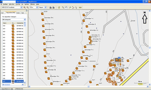
By the end of the project week, the majority of the pupils had gained technical operative competence in the use of the digital mapping system, MapSource (simple GIS) and were able to upload waypoints, display them, and change symbols and texts. Many pupils had also mastered sorting waypoints as separate themes (layers) on the map (see for an example of a thematic map created using the digital map tool). Most of the pupils mastered both usage that required evaluation skills and usage containing analytical elements related to the possibilities that the map tool presented.
Fig. 2. Screen dump of a map showing possible sites for nesting boxes, obtained from a hand-held GPS receiver. Image reproduced with the kind permission of Garmin.

As a supplement to the pupils’ work, I carried out some individual pre- and post-project tests related to competence in the use of scales, understanding coordinate systems, and abilities in reading and interpreting a map. With regard to the use of scales on maps, the younger pupils (Grades 6–7) achieved a significantly better (p < 0.05, Sign test) score in the test immediately after the project had finished than before it had started (Cyvin Citation2010). The other data from these pre- and post-project tests did not show clear results from the pupils’ work with digital tools (for further details see Cyvin Citation2009; Citation2010).
Competence in reading, interpreting, and understanding maps, including competence in the use of scales and understanding the function of coordinate systems
The idea behind the assignments was that practice in creating a map would result in enhanced understanding when using, reading, and interpreting maps. The reason why I did not assess the achievement of these objectives as better than ‘average’ (and possibly only ‘low’ for the coordinate system) is that the pupils’ results were more variable. I therefore evaluated the combined objective achievement as ‘average’. However, many of the pupils acquired a very good level of competence in constructing, reading, interpreting, and understanding a map. Their competence also included making and reading map keys and symbols, as well as working with distances and scales.
Fundamental skills – oral and written
Because the groups of pupils took different amounts of time to complete the assignments, they were given slightly different assignments towards the end of the project. Most of them wrote brief reflective logs and some also drafted newspaper articles about the project. The assignments, along with the user manual for the GPS receiver, and the free-text fields in the questionnaire forms in the pre- and post-project tests all revealed that most of the pupils were able to utilise the concepts and communicate the use of maps and digital tools naturally and with varying degrees of high-order reflection (cf. Bloom 1956). Nevertheless, I chose to assess the pupils’ basic oral and written skills as a ‘high objective achievement’ because I considered that, with some isolated exceptions, all pupils had acquired a good basic knowledge of and ability to communicate on the subject of maps, map usage, and mapping tools. In addition, they were able to apply these skills to new assignments and to a certain degree also analytically.
Results of the pupils’ responses to selected statements before and after the project (pre- and post-project tests)
The pupils (n = 100) in Grades 8 and 9 were asked to give their responses to 28 statements, and the results relating to 3 of the statements are shown in . The selected statements are of relevance for this article, while the others were about science, the environment, and ICT (information and communications technology). I used a Likert scale with four alternatives (‘thoroughly agree’, ‘agree’, ‘disagree’, and ‘thoroughly disagree’) and the pupils were asked before the project started (pre-project) and just after the end of the project period (post-project). Differences in scores before and after were tested for each pupil pairwise using a non-parametric sign test, namely Wilcoxon's Signed Rank Test. For all statements, there was a tendency for the pupils to achieve a higher score after the end of the project, and the difference in scores for the statements ‘I am able to study data by using maps’ and ‘I am able to use a map to analyse nature/environment/technical data’ was significant (). When a similar analysis was done for the two subgroups, the GPS group and the compass group, the tendency was very similar but the GPS group had a higher score than the compass group after the project period. Only in the case of the GPS group and the statement ‘I am able to study data by using maps’ was there a significantly better score after the end of the project. Due to relatively small samples in the subgroups, I do not discuss the differences between the groups further.
Table 3. Sample statements (3 out of a total of 28) for which pupils in Grades 8 and 9 had to give their opinions before and after the project period; the response options were: ‘thoroughly agree’, ‘agree’, ‘disagree’, and ‘thoroughly disagree’; the differences in scores were tested for each student pairwise (n = valid pairs) before and after using the non-parametric Wilcoxon's Signed Rank Test
Challenges in carrying out ICT-based pupil projects
Conducting a research project of the type described in this article may prove challenging. After the year 2000, the USA turned off its satellite filters (installed for military security reasons), which resulted in the accuracy of navigation with GPS receivers increasing from an order of magnitude of 100 m to 10 m. GPS receivers as off-the-shelf items were new and plagued with problems that mainly related to the installation of the accessory software. When the research project was carried out (in the years 2005–2006), GPS receivers were still relatively new on the general market. Based on my own experiences with a number of different GIS software packages (e.g. ESRI, Pumatec, and OziExplorer), I chose what seemed to be the most simple solution, namely to use the software included with the GPS receivers. The purchased receivers functioned extremely well, were reliable, watertight, and their user-friendliness meant even pupils in Grade 6 (11–12 years) could master them. The drawback in using the accompanying software was that the available maps were limited, and the only alternative was the topographic vector-based maps at 1:50,000 from Garmin. The latter maps were at a somewhat coarse scale for the objective, but this disadvantage was outweighed by the benefits provided by excellent interaction between the GPS receivers and the map program. The installation of the software onto computers presented several challenges with regards to the sequence for installation of software and drivers, and restarting the computers, as expected with computers and software produced c.10 years earlier.
Main technical challenges for the pupils were logging on to the school network, storing files locally versus on the server, remembering to save files, as well as remembering to bring extra batteries when doing fieldwork. Sometimes there were problems with connecting and disconnecting the GPS receivers (via a USB), and occasionally there were problems with memory sticks. Based on my evaluation of the technical issues, I nevertheless reached the conclusion that the challenges of using GPS software, once installed, were neither better nor worse than the use of other software in a school context, such as word processing or spreadsheets.
In terms of organisation, it is likely to be a challenge for a teacher to carry out such investigative, open-ended projects if control is important. In such situations, the teacher should have the courage to relinquish control occasionally and let the classroom be a little chaotic, and thereby let the teaching become more pupil-centred than teacher-centred. Several authors (e.g. Cuban Citation2002) discuss to what extent the use of ICT tools can be a catalyst for such processes or whether they should be independent of the technology.
Through the research project, I experienced that pupils were generally enthusiastic and positive, and their work showed that much had been achieved during the approximately 15 lessonsFootnote1 while the project was running. Although the teachers were positive participants in the project, some evidently had a fear of the unknown.
Since 2005, there have been technical developments in hand-held GPS receivers, and today GPS receivers are integrated in many devices, such as fitness watches and mobile phones. Mobile devices with apps (applications) provide several extended functions compared to classic hand-held GPS receivers. This includes interaction with the Internet and other applications, in addition to the standard functions of recording coordinates and showing the waypoints on a digital map and then exporting them in a standard format (KML or GPX format) to a computer.
The pedagogical challenges related to working with maps and working with coordinates are quite similar. For this reason, I do not discuss all of the technical details in depth in this article. However, it should be noted that the widespread use of GPS technology in mobile phones makes it highly relevant to bring the technology into the classroom, as there is potential for the increased utilisation of commonly available technology as pedagogical tools in the future.
Discussion
When I started the project, I was aware of the challenge of implementing in the classroom as a participant observer. The combination of being responsible for the teaching processes and simultaneously being responsible for observing and collecting data was demanding. This in turn affected the decisions about the research design and the ways to collect data. The challenge of working as a participant observer can be discussed from a wide range of perspectives, such as teaching experiments, classroom-based research (action research), and the development of curricular material (cf. Kelly & Lesh Citation2000), but in the analysis of the project for this article I regarded the data as representative of a teaching experiment with two pupil groups.
I had control of the teaching programme as far as possible when working with pupils as individuals, to ensure that the teaching would be done as similarly as possible in all participating classes and in the two groups working with different tools. This approach worked much as intended, with a few exceptions, such as participating assistant teachers intervening and giving pupils an early answer when the pupils were supposed to make their inquiries on their own. Such situations were logged, but because they were very seldom it was assumed that they did not to affect the overall results.
In cases where I had decided not to film or record the pupils, it was difficult to document adequately many of the learning-related interactions among and between them. The decision not to film or voice record was a pragmatic decision due to the fact that I did not have enough resources to make well-organised recordings and to carry out the time-consuming analysis of the huge amounts of data that would have been generated. Rather, my documentation is based on written daily logs and saved copies of all of the pupils’ work. In addition to the project work, the pupils completed tests and questionnaires before and after the weeks when the project work was done.
Based on observations, logs, questionnaires, and the pupils’ work emanating from the project, I see no reason why the national curriculum should not include a more inquiry-based approach to topics such as coordinates and maps within all four subjects (science, social studies, mathematics, and physical education) where feasible. In addition, the progression in the national curriculum could have been better co-ordinated, making it easier to create interdisciplinary projects concerning the use of maps.
There is a lack co-ordination between the curricula for science, social studies, physical education, and mathematics with respect to progression in mapping- and coordinate-related topics. The subject curricula are structured on a common template of purpose, main areas, number of teaching hours, teaching objectives, and basic skills (in terms of literacy, numeracy, and ICT skills), and in relation to the overall guidelines regarding freedom in teaching methods, less detailed curricula, less comprehensive curricula, and cohesive curricula in schools from Grade 1 (primary school) through to Grade 13 (upper secondary school). Mikkelsen (Citation2008) provides a brief summary of the justification for the overall approach taken in the subject curricula with respect to the common template produced by politicians and school bureaucrats.
Further, there is a lack of instruction in the use of ICT in connection with maps that require more than reading a digital map on a screen. The curriculum (L06) introduced ICT skills as one of five basic skills for pupils, and despite the intention to allow freedom of choice in teaching methods, there are many detailed instructions relating to the use of digital maps (cf. ).
Some reflections on the current curriculum are noteworthy. The technical and economic point of view is relevant; GPS receivers were still relatively expensive in 2006 and schools faced technical challenges in implementing the technology in classrooms. Some of the problems and challenges regarding teaching GIS in schools are well described in a Danish study (Nielsen & Horn Citation2006). The developments in integrated GPS functions in mobile phones will weaken any economic arguments against introduction of such technology in the future. The technical situation has also changed as a consequence of many free Internet resources and apps being accessible via computers and mobile phones.
In 2006, when the Norwegian national curriculum called the Knowledge Promotion Reform (L06) was published, many teachers lacked competence in the use of technological tools. Today, there may still be a lack of competence among some teachers, but this situation is likely to change rapidly as out-of-school use becomes increasingly common and with improved user interfaces on devices and software. According to Rød et al. (2001), the democratisation of GIS started already in 1995, but I claim that the democratisation process moved slowly until 2006, and then accelerated thereafter. Hence, the situation today regarding more widespread use of map-based technology could be more ‘mature’ than in 2006.
In the following section, I present some thoughts on my experiences of the implementation of the approached in the project, based on the various pedagogical and didactic approaches that formed the basis for planning the research project.
Concluding remarks
The results of the completed project show that it is possible to conduct authentic inquiry-based interdisciplinary projects using digital mapping tools that are beneficial for pupils in primary and lower secondary schools. Such interdisciplinary projects may result in a somewhat low academic outcome within each narrow subject discipline compared to subject-specific teaching. However, in my project the pupils gained technical and social knowledge and skills, and the results from the pre-/post-project tests with statements about map usage indicate that the pupils had at least improved their confidence in their own competence in their ability to study data by using maps (). The acquired competence should encourage the pupils to use maps as powerful tools for reading and interpreting data in the future. Even if there was no significant difference in scores relating to two of the statements – ‘I can use maps on the Internet to locate addresses’ and ‘I am able to use a map to analyse nature/environment/technical data’ – there was still a tendency for pupils to score higher after the project period.
The amount of knowledge and skills that pupils would gain after a project such as the one I carried out would be useable across disciplines, in society at large, and in everyday problem-solving, and would outweigh any missed educational components related to individual subjects. This finding may be in line with Appleton (2007, 506), who argues that decisions to integrate are ‘difficult to justify from a traditional subject perspective but could be justified from different philosophical perspectives such as humanism or holistic learning’. My project shows that it is possible to start early in the class hierarchy with inquiry-based projects using digital tools similar to those described in this article. I hope the next revision of the national curriculum will allow more subject curricula to incorporate methodology goals that are a component of the distinctive character of the respective subjects, and that attempts are made to harmonise the competence objectives that are part of several subjects in order to facilitate interdisciplinary projects.
Acknowledgements
I thank Sør-Trøndelag University College for supporting the study through a PhD grant, my supervisor Professor Doris Jorde for her advice during the study and the writing, my colleague Associate Professor Anne B. Lund for comments on the article, and last but not least I am very grateful to the headmasters, pupils, and teachers of the lower secondary schools for an inspiring and joyful field study period at their schools.
Notes
1. The number of lessons differed slightly between the different groups of pupils.
References
- Anderson , R.D. 2007 . Inquiry as an organizing theme for science curricula . Abell , S.K. & Lederman N.G. Handbook of Research on Science Education , 807 – 830 . Lawrence Erlbaum Associates , Mahwah , NJ .
- Appleton , K. 2007 . Elementary science teaching . Abell , S.K. & Lederman N.G. . Handbook of Research on Science Education , 493 – 536 . Lawrence Erlbaum Associates , Mahwah , NJ .
- Baker , T.R. 2002 . The Effects of Geographic Information System (GIS) Technologies on Students’ Attitudes, Self-Efficacy, and Achievement in Middle School Science Classrooms . PhD thesis. Department of Teacher and Leadership, University of Kansas , Kansas .
- Bloom , B.S. , Engelhart , M.D. , Furst , E.J. , Hill , W.H. & Krathwohl , D.R. 1956 . Taxonomy of Educational Objectives: The Classification of Educational Goals. Handbook 1: Cognitive Domain . David McKay , New York .
- Burrough , P.A. & McDonnell , R.A. 1998 . Principles of Geographical Information Systems . Oxford University Press , London .
- Chinn , C.A. & Malhotra , B.A. 2002 . Epistemologically authentic inquiry in schools: a theoretical framework for evaluating inquiry tasks . Science Education 86 , 175 – 218 . doi: 10.1002/sce.10001
- Cuban , L. 2002 . Oversold and Underused . Harvard University Press . Cambridge , MA .
- Cyvin , J. 2009 . Map interpreting skills – a classroom experiment with and without ICT among lower secondary school pupils in Norway . Problems of Education in the 21st Century 16 , 40 – 47 .
- Cyvin , J. 2010 . ICT: The final solution to teaching and learning or ICT as an expensive learning tool that takes the focus away from subject content learning? Černochová , M. ATEE Winter Conference: Early Years, Primary Education and ICT: First Class Learning, First Class Teaching, First Class Teacher Education: the Primacy of Early Years, Primary Education and ICT for the Future of Europe: February 26-28, 2010, Prague, Czech Republic: Working Proceedings of Keynote Speakers, Papers, Workshops and Posters , [unpaginated] . University of Prague , Czech Republic .
- Dewey , J. 2000 [1916] . Utdanning til demokrati. Barnet, skolen og den nye pedagogikk: John Dewey i utvalg . Vaage , S. (ed.) . Abstrakt Forlag , Oslo .
- Driver , R. , Asoko , H. , Leach , J. , Mortimer , E. & Scott , P. 1994 . Constructing scientific knowledge in the classroom . Educational Researcher 23 , 5 – 12 . doi: 10.3102/0013189X023007005
- Engelsen , B.U. 2012 . Enkeltfag i flerfaglige og tverrfaglige opplegg: Fagdidaktikk i lærerutdanningen . Bedre Skole 3 2012 , 20 – 22 .
- Hasmadi , I.M. & Imas , S.S. 2010 . Empowering GIS education program: Is GIS as a science, art or tool? Journal of GIS Trends 1 , 1 – 7 .
- Isnes , A. 2005 . Nye læreplaner i norsk skole – hva og hvorfor? NorDina 2 ( 2005 ), 86 – 90 .
- Isnes , A. 2007 . Læreplanverket i Kunnskapsløftet . Hølleland , H. På vei mot kunnskapsløftet , 196 – 199 . Cappelen Akademisk Forlag , Oslo .
- Kelly , A.E. & Lesh , R.A. 2000 . Handbook of Research Design in Mathematics and Science Education . Lawrence Erlbaum Associates , Mahwah , NJ .
- Lave , J. & Venger , E. 1992 . Situated Learning: Legitimate Peripheral Participation . Cambridge University Press , Cambridge .
- Mikkelsen , R. 2008 . Geografi og Kunnskapsløftet . Fjær , O. & Eikli , E. (eds.) . Geografi og Kunnskapsløfte , 9 – 26 . Acta Geographica–Trondheim, Serie B, No. 15. NTNU , Trondheim .
- Nielsen , K. & Horn , F. 2006 . GIS i folkeskolen – fra ide til virkelighed . MONA 3 ( 2006 ), 24 – 43 .
- Roth , W.-M. 1995 . Authentic School Science: Knowing and Learning in Open-Inquiry Science Laboratories . Kluwer Academic , Dordrecht .
- Scott , P. , Asoko , H. & Leach , J. 2007 . Students conceptions and conceptual learning in science . Abell , S.K. & Lederman N.G. Handbook of Research on Science Education , 31 – 56 . Lawrence Erlbaum Associates , Mahwah , NJ .
- Utdanningsdirektoratet . 2006 . Læreplanverket for Kunnskapsløftet, Fag og læreplaner . http://www.udir.no/Lareplaner/Grep/ (accessed November 2012) .
- Vygotsky , L.S. 1986 [1934] . Thought and Language . MIT Press , Cambridge , MA .