
ABSTRACT
While there have been academic discussions regarding the strategic and relational shift in spatial planning, and the potential of digital geospatial planning support systems (PSS) in this regard, the integration between these two has been given less attention. Understanding the obstacles associated with this integration is crucial to enhance strategic spatial planning and the utilization of geospatial PSS in this respect. To address this gap, the authors examine the tensions that arise when the planning systems of three municipalities in Norway intersect with the potential capabilities offered by a 3D digital twin. The authors found that the study findings not only supplemented those of studies concerned with the implementation gap, but also provided more general insights into possible obstacles for a strategic turn in spatial planning. In conclusion, they identify five key tensions in the Norwegian planning system that affect the uptake of a 3D digital twin.
Introduction
The potential of geospatial digital planning support systems (PSS) in strategic planning – the possibility to explore, analyse, design, and monitor spatial issues through handling large amounts of data and also visualizing them – seems to be great (Geertman & Stillwell Citation2020). However, such digital tools have not yet lived up to the expectations in real life planning contexts (Geertman Citation2006; Citation2017; Vonk & Geertman Citation2008; te Brömmelstroet & Schrijnen Citation2010; Geertman & Stillwell Citation2020; Jiang et al. Citation2020a). Scholars specializing in planning support systems (PSS) refer to this as the ‘implementation gap’, a mismatch between the supply and demand sides in the development of such systems (Vonk Citation2006; Vonk & Geertman Citation2008; te Brömmelstroet & Schrijnen Citation2010; Geertman Citation2017), and much analytical concern is focused on describing and attempting to understand the reason for this gap. Some scholars point to weaknesses in the technology or attitudes and skills on the demand side (Vonk & Geertman Citation2008), while others blame an ineffective dialogue between modelers and planning practitioners (Pan et al. Citation2022).
However, despite the importance of understanding how and to what degree digital PSS may contribute to strategic planning, there is currently a shortage of studies that link the studies of PSS – and hence also geospatial PSS, which integrates geospatial data and technologies – with theories of strategic planning. With this gap in mind, in this article we contemplate the obstacles encountered when a 3D digital twin meets the Norwegian strategic planning system.
After an initial introduction to the research project and the concept of digital twin, we provide the theoretical foundation for our analysis, highlighting the call for a more strategic role in planning, along with pertinent literature concerning the implementation gap. Thereafter, we expound on our methodology and elucidate the sources from which our data are derived. Subsequently, we delve into the challenges that emerge as the planning system envisions the integration of a digital twin for strategic objectives. Finally, we provide concluding remarks on how the study contributes to enhancing our understanding of the intersection between the strategic shift in planning and the utilization of PSS.
The planning system facing a digital twin
The empirical basis for this article was laid in the project SmartPlan initiated in 2020, one year after the decision among the Norwegian municipalities Ålesund, Giske, and Sula, which together are defined as the Ålesund region for the purposes of this article, to develop jointly an inter-municipal master plan for climate, land-use, and transportation (Plan for areal, klima og transport, PAKT). In the project, an attempt was made to fit a dynamic 3D digital twin into the planning process. The technology was to be provided by Offshore Simulation Centre (and later its subsidiary AugmentCity), which over 15 years has developed a world-leading technology for simulation and visualization within the offshore industry. The ambition was to design and make use of this technology to visualize and simulate big data, relevant for sustainable municipal and regional planning.
Although the definitions of digital twin are many (Liu et al. Citation2021), it may be defined as follows:
dynamic representation of a real-life object that mirrors its states and behaviour across its lifecycle and that can be used to monitor, analyse and simulate current and future states of and interventions on these objects, using data integration, artificial intelligence and machine learning. (Verdouw et al. Citation2021, 4–5)
Fig. 1. Screenshot of a digital twin visualization of the Ålesund area (Photo: Else Ragni Yttredal, 20 February 2023)
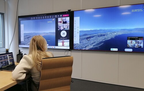
One of the ambitions of the SmartPlan project was for regional planners to be able to inspect a wide range of geospatial information from different geographical viewpoints in a 3D visualization while navigating through the time dimension in 4D replay. However, despite the explicit implementation emphasis in the project, the potential of the available technology is not yet realized, and the regional plan was approved in May 2022 without the use of a digital twin, whereas the SmartPlan project was finished by end of 2023.
Theoretical framework
The PSS implementation gap
The term planning support systems (PSS) originated in the 1980s from literature related to geoinformation technology (Harris Citation1989; Pelzer Citation2015). However, while still having a firm basis in geospatial applications (Daniel & Pettit Citation2022), the concept of PSS has included a broader understanding as ‘computer automated tools that can assist planners to more effectively undertake their day-to-day professional tasks’ (Geertman & Stillwell Citation2020, 1327). PSS have garnered recognition for their potential to facilitate and support planning processes effectively (Geertman Citation2006; te Brömmelstroet & Schrijnen Citation2010; te Brömmelstroet Citation2017; Pelzer Citation2017; Geertman & Stillwell Citation2020). However, decades of experience and studies show that though the uptake of PSS in practice has improved in recent years, the implementation gap remains to be closed, both in an international and Norwegian context (Nordtveit & Hernes Citation2016; te Brömmelstroet Citation2017; Geertman & Stillwell Citation2020; Jiang et al. Citation2020a; DIGIPLAN Citation2021a; Citation2021b). There are still concerns that PSS are considered insufficiently sensitive and attuned to the specific demands of planners and the characteristics of the planning process’ (Pelzer et al. Citation2015, 639). Recently, in PSS research, there has been an increasing emphasis on the importance of context, ‘the real circumstance or situation in which a PSS tool is embedded in planning practices’ (Jiang et al. Citation2021, 222). The argument is that the deciding factor is for PSS technologies to be localized and adapted to the planning context: ‘for technology to be of added value to practice, it should be attuned to the wishes and capabilities of the intended users’ (Jiang et al. Citation2020a, 1343). Thus, to understand the needs of users in a planning context has proven very important for the success of PSS applications (McEvoy et al. Citation2018).
There are two main strands of research that recognize the importance of dealing with the contextual factors. One approach is to map and unmask the different contextual factors that should be taken into consideration in PSS design processes (te Brömmelstroet Citation2010; Deal et al. Citation2017; Geertman Citation2017; Pelzer Citation2017; Russo et al. Citation2018; Zhang et al. Citation2019; Jiang et al. Citation2021). Such demand-side studies bring forth knowledge about which contextual factors are important for the usefulness of PSS, and thus may potentially work as design guidelines for PSS developers. For example, Jiang et al. (Citation2021) claim that especially characteristics of the technology, the users, the planning process, and the political context influence the usefulness of PSS.
The other strand of research reduces the challenge of including context in the design of PSS to a procedural one, where the main problem stems from the lack of an authentic dialogue or real cooperation between planners and modelers (Pelzer et al. Citation2015). For example, Geertman (Citation2017, 73) claims that ‘the acceptance of PSS in planning organizations is mostly hampered by insufficient cooperation between planners and PSS experts, and by insufficient communication within the organization, especially between organizational management and innovative precursors’. A ‘mixed model’, an incremental process in which the PSS is developed in close connection with planners, was introduced as early as 1988 (Vonk & Geertman Citation2008). More recently, Ahrweiler et al. (Citation2019) have developed a participatory approach to codesigning decision models, Page et al. (Citation2020) have provided a four-stage model, and Goodspeed & Hackel (Citation2017) have proposed seven lessons for the creation of PSS, and Pan et al. (Citation2022) have presented a framework for PSS-facilitated participatory planning. Hence, recommendations and principles for the dialogue have been provided, methods for interactive system development exist, and even a complete framework describing a step-by-step process has been developed in what is termed mediated planning support (te Brömmelstroet & Schrijnen Citation2010). In this strand of literature there is, in other words, agreement that an important requirement to narrow the implementation gap is ‘to encourage communication and collaboration among those involved: the modelers themselves, the clients and stakeholders, the suppliers of data, the users of the model outputs and so on’ (Gilbert et al. Citation2018, 15).
Both approaches, mapping the demand-side and designing a better dialogue, tend to treat the planning system as a context that, even if it is complex, is still relatively stable (Jiang et al. Citation2020b; Citation2021; Pelzer Citation2017). In the section ‘Inherent tensions regarding the implementation of a 3D digital twin in strategic planning’ we emphasize that the planning system is characterized by tensions, by yet unanswered questions about what planning is and should be, especially if we talk about strategic planning rather than statutory planning. These tensions, we will claim, must be taken into account, since they represent disturbances in the implementation process. The problem of implementing a digital twin, which may be understood as a geospatial PSS into a strategic planning process is partly explained by tensions in the planning system itself.
Towards strategic spatial planning
A core ambition in strategic planning is to avoid a random development narrowly guided by economic goals, but the problem facing planners is still, almost 60 years after the publication of the classic article by Edward Banfield (Banfield Citation1959, 363), that ‘the most important decisions - those constituting the developing course of action - are the result of accident rather than design; they are the unintended outcome of a social process rather than the conscious product of deliberation and calculation’. How to achieve a more planning-oriented development is a matter of dispute, even though planning has changed profoundly over the recent decades (Gunder et al. Citation2017).
Following its peak during the three decades after World War II, planning theorists started to question the ability of the rational model to address complex problems. Inspired by the work of German philosopher Jürgen Habermas, communicative planning theory has since the 1990s displaced the hierarchical, authority-based instrumental public planning of the Keynesian welfare state:
Any planning theory needs a notion or an idea of how things are related, how society works, how cities work. In contemporary planning theory, the perhaps most popular version of such an idea is the collaborative, consensual approach of communicative theory. Here, the narrative suggests that the best result emerges through the perfect deliberative discussion. According to the framework of communicative theory, the task of planning theory is to organize consensus. (Roskamm Citation2015, 396)
Although Habermas’ discourse ethics is increasingly becoming an ideal, also for planners, many classical planning challenges are still unresolved. Social, environmental, and economic development is still only marginally a result of interventions by planners. Scholars are increasingly starting to question the ability of Habermasian-inspired communicative planning theory to deal with the complexity of modern society. Chantal Mouffe’s agonistic pluralism and its take on conflicts (Mouffe Citation1999) is claimed by Metzger (Citation2018) to answer many of the challenges facing planners today. Agonistic pluralism rests on an antifundamentalist understanding of the social as contingent, which means that a stable consensus is impossible to achieve (Bond Citation2011); antagonism is ineradicable. Mouffe regards consensus-seeking as a process where identities are marginalized rather than liberated. Therefore, consensus without dissent would entail that opposing views have been externalized from the planning process. Therefore, in agonistic pluralism, antagonisms cannot and should not be left behind but turned into agonisms, which is why the following is important:
[that] open societies do not seek to suppress or deny the existence of fundamental political differences. These must instead be allowed to find public forums in which they can be explored and articulated in ways that can contribute to ‘taming’ potentially violent antagonism into democratically productive agonism. (Metzger Citation2018, 182)
The invitation not to attempt to ‘tame’ complexity should not be mistaken for pure incrementalism (Lindblom Citation1959): ‘Too much fluidity, or fluidity going ‘wild’, would mean not only losing control, but also, in a sense, giving up the ambition of steering, which would certainly give other forces more room to maneuver’ (Davoudi Citation2017, 24). The advice is therefore not to become reactive in the face of complexity, but rather to act more strategically (Albrechts Citation2017). By strategic spatial planning is meant a ‘self-conscious collective effort to re-imagine a city, urban region or wider territory and to translate the result into priorities for area investment, conservation measures, strategic infrastructure investments and principles of land-use regulation’ (Healey Citation2000, cited in Albrechts Citation2017, 29). Strategic planning is, in other words, pro-active, holistic, visionary, and cooperative, which means that it poses a challenge to the traditional planning system that values such things as transparency, responsibility, legitimacy, and accuracy.
Graham & Healey (Citation1999, 633) conclude that ‘these new ideas are slow to filter into the world of planning practice’, and Davoudi (Citation2017, 19) adds that ‘the intellectual and practical challenges of embedding relational space into spatial planning practices have not been fully developed’. The planning system might recognize that space is not absolute and that planning should ideally not only be about creating order, but it is therefore not evident how to steer the fuzziness of relational space, as ‘the planner’s insecurities in navigating and prioritizing between them [strategies] displays an absence of frames of reference for which problems and solutions to focus on’ (Trygg & Wenander Citation2022, 1997). This way of thinking is difficult to translate into the legal administrative confines of planning practice.
However, there is currently a shortage of studies that link the implementation gap of geospatial PSS with the ongoing turn towards strategic planning. Our research has aimed to address this gap by establishing a connection between the endeavours to create a 3D digital twin for strategic objectives, all the while investigating how this tool could be effectively applied to enhance strategic spatial planning and facilitate a strategic turn in this domain.
Method
We used an iterative and reflexive process (Srivastava & Hopwood Citation2009), in which four distinct types of data were collected and combined from October 2019 to May 2022 (). One set of data was generated through our participation in and study of the design process for a 3D digital twin intended for strategic planning. In order to guide the digital twin design process, two workshops and six discussion meetings were held during the project period. The participants in these sessions were primarily councillors and planners representing the three municipalities in the Ålesund region. During the workshops, the opportunities and barriers associated with the application of geographically based 3D or 4D visualization tools in planning for sustainability were discussed.
Fig. 2. The main groups of data sources used iteratively in the study
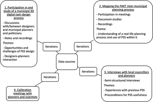
The second data source originated from the study of the intermunicipal PAKT planning process, which extended from autumn 2020 to February 2023. Through inquiries and observations during that process, we gained valuable insights into the requirements and dynamics of strategic planning, as well as the utilization of geospatial PSS within it. Our data collection encompassed various activities, including active participation in steering group meetings (totalling six), and thorough examination of planning documents associated with the PAKT process. The documents consisted of the planning programme, plan drafts, attachments presented in steering group meetings (including the plan’s knowledge base), and the minutes from meetings conducted throughout the process.
Third, we conducted semi-structured interviews with 10 local councillors and 11 planners representing the three municipalities engaged in the PAKT planning process. The interview guide encompassed enquiries about planning challenges, digital competencies, experiences with current digital platforms, and technical issues. The primary objective was to identify the key challenges of map-based and geospatial planning support systems within municipal planning processes, with a specific focus on the potential of a digital twin for sustainable planning. To analyse the interview transcripts, NVivo software (version 14.23.2, Lumivero LLC) was employed. Initial coding of the data involved grouping responses into categories and consolidating them into overarching challenges, following the approach outlined by Saldaña (Citation2016). Fourth, the findings underwent expert discussions and calibration throughout the project, involving members of the project group and stakeholders from the municipalities.
During data collection and analysis we capitalized on first and foremost planning theories and findings from the PSS literature alongside the content stipulated within the Norwegian Plan and Building Act of 2008 (Kommunal- og distriktsdepartementet Citation2008). The Act mandates planning activities across all regions of the country, and it continues to be regarded as the ‘planning constitution’ (Fiskaa Citation2014).
It is important to note that the digital twin under consideration was in its early stages of development and not yet ready for real-time usage. Therefore, our investigation primarily entailed reflections on the potential application of digital twin in strategic spatial planning, as well as the experiences of planners and other stakeholders with existing geospatial PSS within the municipalities While it may be argued that such an approach is somewhat premature, its merit lies in enabling us to track a real-time endeavour in designing a 3D digital twin. Moreover, our approach facilitates the integration of design efforts with ongoing research and real-time planning processes, thereby addressing the associated challenges.
Inherent tensions regarding the implementation of a 3D digital twin in strategic planning
Through an iterative utilization of the data and methods, we derived at a set of five impediments that hinder the effective integration of a digital twin in the realm of strategic planning. The challenges have not evolved from an exhaustive investigation into all aspects of the available modelling and visualization tools for all relevant actors in the planning context. Rather, we have, from an overall assessment of the qualities of the tool, interviews, theories, and expert discussions during the process, found what we perceive as main challenges. In addition to the implementation gap, planning theories claim that the planning system itself faces challenges in the transition from modernist to strategic spatial planning. The challenges we have arrived at therefore combine general tensions in planning practice with the hesitations that were presented to us by planners.
Selective or comprehensive planning?
Traditional spatial planning normally concerns itself with the production of plans as a reaction to problems and challenges. Within the Norwegian planning system, multiple plan types required by law exist (Kommunal- og distriktsdepartementet Citation2022). Plan types vary in terms of their settings, themes, areas, and involved stakeholders. Furthermore, municipalities are legally obligated to undertake a range of responsibilities (Kommunal- og distriktsdepartementet Citation2008, § 3-1), to secure land resources, landscapes and cultural values and facilitate good shaping of built environment, living environments and conditions, and good upbringing, to mention a few. Thus, potential themes within a single land-use planning process may be almost infinite. However, the object of strategic planning is to develop policies and frames, not plans, that ‘serve only (mainly) as binding documents to obtain building permits’ (Albrechts Citation2017, 31).
In order to ‘face’ power in an effective way, strategic planners are urged to be selective, and therefore abandon the search for total inclusion that is urged for in the planning law. This leaves the planning system in a state of tension. There are many unanswered questions in a strategic turn, such as how to develop a vision independently of legal requirements, one that may have to be translated into operational formal plans to make an impact (Ringholm & Hofstad Citation2018, 107–108). To understand what strategic planning is in this context is therefore a complex undertaking in itself. Higdem & Kvalvik (Citation2018) have pointed out that regional plans tend to be broad thematic documents that are neither visionary nor action-oriented. One interviewee who was central to the PAKT planning process made the same point:
The challenge is that tasks are overlapping, they are cross-sectoral and involve many disciplines. It is difficult even for me [being central to the planning process] to get an overview. It is complex and difficult to deep-dive into the subject matters. As a result, the plans often become abstract and general, about obvious things that are hard to disagree on. (Planner 7)Footnote1
Firstly, has account been taken of the current housing for elderly, which the municipality owns? What about future projections for this group seen in relation to living patterns? The second question: This matter about autonomous boat routes. […] boat versus car. Are tolls included? Tolls will affect pricing.
Allowing for or eliminating conflict?
Modernistic planning strives to overcome conflicts by facilitating the establishment of a common ground between stakeholders (Albrechts Citation2015). By contrast, a strategic planner works differently with conflict (Mouffe Citation1999), it is not to be avoided but rather should be invited into a process where communication about future scenarios take place. For the application of a digital twin in the process, this tension between different conceptions about conflicts in planning probably causes a delay in the implementation process. It is our impression that the ideal of establishing a common understanding dominated the PAKT process. Based on group discussions, one councillor for instance, in a workshop held in February 2023, argued that the digital twin could be useful in different phases of a strategic planning process, but for different purposes:
In the start of the planning process, a digital twin could make it easier to understand the planning area, perhaps also make goal conflicts visible early in the process. Maybe it can also help delimit the process? Then in the next phase [referring to the planning proposal and different knowledge basis]. It could be useful for creating a common understanding of which challenges to be solved at an early stage and create a common knowledge base based on this. A challenge is how to prevent it from being misused, not to be abused by the administration, [by] nerds who can pick out individual variables and claim that they are the fact and from there jump to conclusions. Sobriety for how variables are used is needed. In the final phase the point would be dissemination to stakeholders at various levels.
Probing the future or the ideal of certainty?
Strategizing outside of the formal planning processes following the procedural rules of the Plan and Building Act of 2008 (Kommunal- og distriktsdepartementet Citation2008) may raise questions about whether or not the plan is legitimate. If strategic planning with the use of a 3D digital twin becomes a parallel informal system outside the formal planning system, how could we secure its legitimacy? We found several traces of this dilemma in our data.
Norwegian municipalities are legally bound to document municipal planning processes. One planner found this quite challenging, referring to the use of another geospatial PSS in a previous planning process:
A big headache for me was that it was difficult to keep the history clear. There were 300 suggestions from inhabitants to the plan, including the adjustment of boundaries or change of area purpose [on the map]. Everything must be summarized in a protocol that will be valid for 10 years and must be traceable. Discussions and suggestions should also be written down and traceable. One should be able to go back to 2014 and find out why one chose to adjust a certain border in an area. (Planner 1)
A condition for statutory planning and making plans is knowledge, a base of fairly certain assumptions about the consequences of different actions, which the politicians then can choose from. Strategic planners may have another attitude and assume that certainty is an illusion and that there are no clear-cut solutions, and even no clear-cut problems either (Albrechts Citation2006). Although social constructivism has not escaped the planning system, there is still an assumption that ‘certainty is still somewhere to be found’ (Albrechts Citation2017, 321).
The strive for certainty, as an important part of the planning process, is very much an issue in our case. Challenges related to data quality and trustworthiness of the digital twin have been some of the main concerns of planners and local councillors alike. Trust is also discussed in other studies (e.g. Shahat et al. Citation2021). Among the bottlenecks in the implementation process is planners’ scepticism of what are perceived as invisible underlying models and variables of the tools. Such scepticism may be termed ‘acceptance barriers’ (Page et al. Citation2020, 1510). What is of main interest for our purpose is not the data themselves, but how the organizational and procedural context influences what is perceived as trustworthy data sources and models. This evidently influences the intersection between the 3D digital twin and strategic spatial planning.
Furthermore, issues related to presentation and trustworthiness of metadata play an important role in the trustworthiness of a geospatial PSS, as the power of digital visualizations tends to spur discussions concerning data quality (Metze Citation2020). As in other cases, administration and security of data used in the geospatial PSS are organizational and technical issues that potentially lower or raise trust levels, also affecting the ‘acceptance barriers’ (Page et al. Citation2020). This demonstrates how the search for certainty may hamper the process of implementing digital tools.
Representing or coproducing public interest?
Connected to the question of legitimacy is the risk that strategic spatial planning introduces an unclear relationship between the state and its citizens. The strategic planner abandons any notion of representativity or the idea of a planning system that acts on the basis of aggregated interests, and instead engage themself in coproduction as a political strategy. The planner does not produce spatial imaginations based on the way that relevant stakeholders already represent space but instead co-produces, with the same stakeholders, new socio-spatial imaginations. This conception of what planning is challenges our traditional ideals, such as justice, equity, and accountability. This tension, between coproducing strategies or aggregating existing interests, runs through many of the questions raised by the planning system dealing with the PAKT process. Planners were, for instance, concerned about the communication between local councillors and the administration, and between inhabitants in general and the municipality.
The biggest challenge is to engage both politicians and citizens in a planning process. There are no in-depth discussions. In general, the administration lays the foundation of the plan, followed by small adjustments from the local councillors. (Local councillor 1)
Some [planners] still use [digital] planning tools, drawing tools, etc., but this has recently become less common. It is often either the consultants who do this work, or we have a separate geodata department that works with drawing programmes. This means that it is now uncommon for us planners to draw something ourselves. (Planner 2)
Theories highlighting the qualitative aspects of participation (Arnstein Citation1969; Brabham Citation2013; Babelon Citation2021) and our endeavours to establish a participatory digital twin have demonstrated that the effectiveness of the digital tool for communicative purposes hinges upon its deliberate alignment with a specific purpose of fostering participation. We found that that the digital tool merely served as an instrument or facilitator during workshops, as the nature and quality of participation predominantly relied on the dynamics of the participatory setting.
The challenge of incorporation into an existing system
According to Healey (Citation2007, 21), strategic spatial planning is challenged by the fact that the governing of urban space ‘appear[s] to be performed through routinised practices embedded in powerful relations and cultural assumptions that seem to hold them in place, despite energetic efforts to change them’. Alternative views of planning have to face ‘the routinised practices and discourses of established agencies and formal government’ (Healey Citation2007, 22) One such routine is the way actors already make use of technology in their planning. New technical solutions need to be implemented in an organizational and planning procedural context. For example, given that a ‘technology should be implemented only when it can add value to governance practices’ (Jiang et al. Citation2020a, 1356), one question is whether the actors already use statistics, maps, GIS tools, and models, and for what purpose. In the municipal organizations of the Ålesund region, existing geospatial digital platforms (WebInnsyn/GeoInnsyn) were already in use. Consequently, resources have been invested in building up and maintaining the platform over several years. One of the employees dedicated to working on the platform expressed the following:
We have annual rounds where we go through the data and remove or add maps and documents. (Planner 2)
Now, I don’t do strategic planning, but for spatial planning, so they [WebInnsyn] are invaluable. (Planner 3)
It also became apparent that lack of operational skills and the complexity of the interface prevented many of the councillors from using existing map-based digital PSS. By contrast, Google Maps turned out to be the preferred map-based digital tool among many councillors because its interface provided easy access to geographical overviews.
Furthermore, multiple sources highlight the concern regarding format compatibility. Significant data might be presented in a format unsuitable for integration into a geospatially oriented digital replica, thereby diminishing the emphasis on specific domains of relevance and consequently excluding vital alternatives and perspectives from the purview of planning decisions. Adding to this, in the Norwegian system, as in many other countries (DIGIPLANl Citation2021a; Citation2021b), the customization of data formats for municipal purposes is insufficient.
The findings illustrate how new technical solutions are introduced into contexts in which technological choices have already been made, creating path dependencies on personal, technical, and organizational levels (Jakobsen et al. Citation2012). Such challenges are potentially difficult to overcome. Corresponding with this, we found that early in the research process, especially among planners and administrative leaders there were concerns about the structural consequences of a new digital twin for the municipal organization. The challenges may be structured into procedural, structural, and cultural ones (Scott Citation1981). Examples of procedural concerns include the need for new digital checklists, new procedures on how to update map layers, and new requirements and laws to keep up with new technology. Structural concerns included the potential need for the reorganization of the municipality to incorporate the tool, but also worries that such a tool may change the need for know-how in the organization, whereas mental or cultural factors include employees’ willingness to change, the need for change management, and how to anchor the geospatial PSS in the municipal leadership. Fear of the financial consequences of applying geospatial PSS is part of the ‘acceptance barriers’ (Page et al. Citation2020), and this was also expressed by our informants.
Conclusions
Confronted with the prospect of using a 3D digital twin in the production of a regional plan, our study brought forward many of the concrete obstacles, not only towards implementation of geospatial PSS, but also towards taking on such a new proactive role. The Norwegian planning system is framed within a conception of planning that does not really demand ways to probe the future, and does not strive to act as a creative and innovative force. A digital twin, applied in the process of producing a strategic regional plan could potentially equip the system with the ability to act strategically, to counter or bring forward alternatives to the conceptions of articulate and powerful groups, but not if the planning system does not view this as its responsibility. Our case study therefore reveals how the perception of the digital twin is influenced by the modernist approach, as it still dominates the planning system.
We would therefore argue that one important reason for the slow uptake of PSS is connected to a more general resistance in the planning system towards turning to a more strategic role. Through our study we discovered that strategic spatial planning is challenged by organizational frictions, uncertainties about the purpose of the planning process, and questions planners and councillors had about who should participate when in the process. Regarding the implementation of the digital twin in question, the planning system furthermore revealed uncertainty about when, how, and by whom the tool could be used, how it can relate to existing software, and to what degree the results it provides can be trusted.
Hence, although stakeholders in the planning system see many possible advantages of a digital twin, their dominating response is to bring their narrow room for manoeuvring and the rigidity of the planning institution to our attention. When planners attempt to take a holistic and integrated view of places, which the regional plan and the implementation of the digital twin exemplifies, our interviewees also had a lot of reservations, concrete questions, and were bound by practical obstacles that needed to be dealt with.
Our study findings not only supplement those of previous studies concerned with the implementation gap, but also provide more general insights into possible obstacles for a strategic turn in spatial planning. Studies of challenges for the planning system in the face of market forces tend to engage with urban planning processes, revealing causes for the inability of urban planning to guide development in a just and sustainable manner. In our study we chose to adjust the lens, from focusing on an investigation of how planners deal with urban complexity, to focusing on the planning system itself and how it responds to a suggested reorganization. We believe that studying how a planning system relates to a digital twin enabled us to tease out complementary knowledge about how the planning system works and what prevents change. A possible implementation of a new tool forced our informants to reveal obstacles that are embedded in the everyday practice of the planning system.
In the promotion of a strategic turn in planning, the rigidity of the planning system should not be underestimated. Strategic planning, which has become more and more fashionable since the 1990s, must always face the national and local planning systems, to which the already dominant ‘rules’ that the planning system abide. This reminds us of the importance of putting due weight on the way that existing spatial practices regulate and discipline, how it permits fresh actions to occur, while suggesting others and prohibiting yet others.
Academics have proposed further investigations into the planning context with the aim of bridging the ‘implementation gap’ – the gap between potential and actual use of PSS in planning (Pelzer Citation2017; Geertman & Stillwell Citation2020; Jiang et al. Citation2020a; Citation2021). We contend that the insights presented in this article regarding the challenges arising when the Norwegian planning system encounters a 3D digital twin are valuable for comprehending the influence of context on the implementation gap related to geospatial PSS. Furthermore, we would argue that these insights furnish valuable knowledge about how the planning system hinders planners from embracing a more strategic and proactive role in planning.
Disclosure statement
No potential conflict of interest was reported by the authors.
Notes
1 All quotations from study participants have been translated from Norwegian into English by the authors of this article.
References
- Ahrweiler, P., Frank, D. & Dilbert, N. 2019. ‘Co-designing social simulation models for policy advise: Lessons learned from the INFSO-SKIN study’. [conference paper]. https://ieeexplore.ieee.org/document/8732901/authors#authors (accessed 29 April 2024).
- Albrechts, L. 2006. Shifts in strategic spatial planning? Some evidence from Europe and Australia. Environment and Planning A: Economy and Space 38(6), 1149–1170.
- Albrechts, L. 2015. Ingredients for a more radical strategic spatial planning. Environment and Planning B: Planning and Design 42(3), 510–525.
- Albrechts, L. 2017. Strategic planning: Ontological and epistemological challenges. Gunder, M., Madanipour, A. & Watson, V. (eds.) The Routledge Handbook of Planning Theory, 28–40. New York: Routledge.
- Arnstein, S.R. 1969. A ladder of citizen participation. AIP Journal July, 216–224.
- Babelon, I. 2021. Digital Participatory Platforms in Urban Planning. PhD thesis. Newcastle: Northumbria University. http://nrl.northumbria.ac.uk/id/eprint/45337/ (accessed 19 April 2024).
- Banfield, E.C. 1959. Ends and means in planning. International Social Science Journal 11(3), 361–368.
- Boelens, L. & de Roo, G. 2016. Planning of undefined becoming: First encounters of planners beyond the plan. Planning Theory 15(1), 42–67.
- Bond, S. 2011. Negotiating a ‘democratic ethos’: Moving beyond the agonistic- communicative divide. Planning Theory 10(2), 161–186.
- Brabham, D.C. 2013. The four urban governance problem types suitable for crowdsourcing citizen participation. Silva, C.N. (ed.) Citizen e-Participation in Urban Governance: Crowdsourcing and Collaborative Creativity, 50–68. IGI Global. eBook. DOI:10.4018/978-1-4666-4169-3.ch004
- Daniel, C. & Pettit, C. 2022. Charting the past and possible futures of planning support systems: Results of a citation network analysis. Environment and Planning B: Urban Analytics and City Science 49(7), 1875–1892.
- Davoudi, S. 2017. Spatial planning: The promised land or rolled-out neoliberalism? Gunder, M., Madanipour, A. & Watson, V. (eds.) The Routledge Handbook of Planning Theory, 15–17. New York: Routledge.
- de Roo, G. 2017. Spatial planning and the complexity of turbulent, open environments: About purposeful interventions in a world of non-linear change. Gunder, M., Madanipour, A. & Watson, V. (eds.) The Routledge Handbook of Planning Theory, 314–325. New York: Routledge.
- Deal, B., Pan, H., Pallathucheril, V. & Fulton, G. 2017. Urban resilience and planning support systems: The need for sentience. Journal of Urban Technology 24(1), 29–45.
- DIGIPLAN. 2021a. DIGIPLAN Final Report: Evaluating Spatial Planning Practices with Digital Plan Data. Targeted Analysis. https://www.dora.lib4ri.ch/wsl/islandora/object/wsl:27456 (accessed 29 April 2024).
- DIGIPLAN. 2021b. DIGIPLAN – Synthesis Report: Evaluating Spatial Planning Practices with Digital Plan Data. https://www.espon.eu/sites/default/files/attachments/ESPON%20DIGIPLAN_Final%20synthesis%20report.pdf (accessed 29 April 2024).
- Fiskaa, H. 2014. Med lov skal land byggast Bygningsloven av 1965 – planleggingas ‘grunnlov’ i Norge. Kart og Plan 74, 32–45.
- Fuller, A., Fan, Z., Day, C. & Barlow, C. 2020. Digital twin: Enabling technologies, challenges and open research. IEEE Xplore 8, 108952–108971.
- Geertman, S. 2006. Potentials for planning support: A planning-conceptual approach. Environment and Planning B: Planning and Design 33(6), 863–880.
- Geertman, S. 2017. PSS: Beyond the implementation gap. Transportation Research Part A: Policy and Practice 104, 70–76.
- Geertman, S. & Stillwell, J. 2020. Planning support science: Developments and challenges. Environment and Planning B: Urban Analytics and City Science 47(8), 1326–1342.
- Gilbert, N., Ahrweiler, P., Barbrook-Johnson, P., Narasimhan, K.P. & Wilkinson, H. 2018. Computational modelling of public policy: Reflections on practice. Journal of Artificial Societies and Social Simulation 21(1): Article 14.
- Goodspeed, R. & Hackel, C. 2017. Lessons for developing a planning support system infrastructure: The case of Southern California’s Scenario Planning Model. Environment and Planning B: Urban Analytics and City Science 46(4), 777–796.
- Graham, S. & Healey, P. 1999. Relational concepts of space and place: Issues for planning theory and practice. European Planning Studies 7(5), 623–646.
- Gunder, M., Madanipour, A. & Watson, V. 2017. Planning theory: An introduction. Gunder, M., Madanipour, A. & Watson, V. (eds.) The Routledge Handbook of Planning Theory, 1–12. New York: Routledge.
- Harris, B. 1989. Beyond geographic information systems. Journal of the American Planning Association 55(1), 85–90.
- Healey, P. 2007. Urban Complexity and Spatial Strategies: Towards a Relational Planning for Our Times. London: Routledge.
- Healey, P. 2018. Creating public value through caring for place. Policy and Politics 46(1), 65–79.
- Healey, P. 2000. Planning in relational time and space: Responding to new urban realities. Bridge, G. & Watson, S. (eds.) A Companion to the City, 517–530. Oxford: Blackwell.
- Higdem, U. & Kvalvik, K.J. 201). Regional planstrategi - strategi for planleggingen eller ny fylkesplan? Aarsæther, N.J. & Hanssen, G.S. (eds.) Plan- og bygningsloven 2008 - en lov for vår tid? 107–118. Oslo: Universitetsforlaget.
- Jakobsen, S.-E., Byrkjeland, M., Båtevik, F.O., Pettersen, I.B., Skogseid, I. & Yttredal, E.R. 2012. Continuity and change in path-dependent regional policy development: The regional implementation of the Norwegian VRI programme. Norsk Geografisk Tidsskrift–Norwegian Journal of Geography 66(3), 133–143.
- Jiang, H., Geertman, S. & Witte, P. 2020a. Avoiding the planning support system pitfalls? What smart governance can learn from the planning support system implementation gap. Environment and Planning B: Urban Analytics and City Science 47(8), 1343–1360.
- Jiang, H., Geertman, S. & Witte, P. 2020b. Ignorance is bliss? An empirical analysis of the determinants of PSS usefulness in practice. Computers, Environment and Urban Systems 83: Article 101505.
- Jiang, H., Geertman, S. & Witte, P. 2021. The effects of contextual factors on PSS usefulness: An international questionnaire survey. Applied Spatial Analysis and Policy 14, 221–245.
- Kommunal- og distriktsdepartementet. 2008. Lov om planlegging og byggesaksbehandling (plan- og bygningsloven). https://lovdata.no/dokument/NL/lov/2008-06-27-71 (accessed 29 April 2024).
- Kommunal- og distriktsdepartementet. 2022. Reguleringsplan: Veileder. https://www.regjeringen.no/contentassets/2804283df64641cea321fdcdcac779f4/reguleringsplan_2022.pdf (accessed 29 April 2024).
- Korenhof, P., Blok, V. & Kloppenburg, S. 2021. Steering representations—Towards a critical understanding of digital twins. Philosophy & Technology 34, 1751–1773.
- Lindblom, C.E. 1959. The science of ‘muddling through’. Public Administration Review 19(2), 79–88.
- Liu, M., Fang, S., Dong, H. & Zu, C. 2021. Review of digital twin about concepts, technologies, and industrial applications. Journal of Manufacturing Systems 58, 346–361.
- McEvoy, S., van de Ven, F.H.M., Blind, M.W. & Slinger, J.H. 2018. Planning support tools and their effects in participatory urban adaptation workshops. Journal of Environmental Management 207, 319–333.
- Metze, T. 2020. Visualization in environmental policy and planning: A systematic review and research agenda. Journal of Environmental Policy and Planning 22(5), 745–760.
- Metzger. 2018. Postpolitics and planning. Gunder, M., Madanipour, A. & Watson, V. (eds.) The Routledge Handbook of Planning Theory, 180–193. New York: Routledge.
- Mouffe, C. 1999. Deliberative democracy or agonistic pluralism? Social Research 66(3), 745–758.
- Nordtveit, I. & Hernes, M.B. 2016. Regionale myndigheters bruk av digital plandialog. https://www.regjeringen.no/contentassets/eebc71d90ac14cf0b3e9ec814129dadc/regionale_myndigheters_bruk_digital_plandialog.pdf (accessed 29 April 2024).
- Page, J., Mörtberg, U., Destouni, G., Ferreira, C., Näsström, H. & Kalantari, Z. 2020. Open-source planning support system for sustainable regional planning: A case study of Stockholm County, Sweden. Environment and Planning B: Urban Analytics and City Science 47(8), 1508–1523.
- Pan, H., Kwak, Y. & Deal, B. 2022. Participatory development of planning support systems to improve empowerment and localization. Journal of Urban Technology 29(2), 33–54.
- Pelzer, P. 2015. Usefulness of Planning Support Systems: Conceptual Perspectives and Practitioners’ Experiences. PhD thesis. PhD Series InPlanning vol. 3. Utrecht: Utrech University. https://dspace.library.uu.nl/handle/1874/312867 (accessed 19 April 2024).
- Pelzer, P. 2017. Usefulness of planning support systems: A conceptual framework and an empirical illustration. Transportation Research Part A: Policy and Practice 104, 84–95.
- Pelzer, P., Geertman, S. & van der Heijden, R. 2015. Knowledge in communicative planning practice: A different perspective for planning support systems. Environment and Planning B: Urban Analytics and City Science 42(4), 638–651.
- Ringholm, T. & Hofstad, H. 2018. Regional planstrategi – strategi for planleggingen eller ny fylkesplan? Aarsæther, J. & Hanssen, G.S.H. (eds.) Plan- og bygningsloven 2008 - fungerer loven etter intensjonene? 107–118. Oslo: Universitetsforlaget.
- Roskamm, N. 2015. On the other side of ‘agonism’: ‘The enemy,’ the ‘outside,’ and the role of antagonism. Planning Theory 14(4), 384–403.
- Russo, P., Lanzilotti, R., Costabile, M.F. & Pettit, C.J. 2018. Towards satisfying practitioners in using planning support systems. Computers, Environment and Urban Systems 67, 9–20.
- Sager, T. 2017. Communicative planning. Gunder, M., Madanipour, A. & Watson, V. (eds.) The Routledge Handbook of Planning Theory, 93–104. New York: Routledge.
- Saldaña, J. 2016. The Coding Manual for Qualitative Researchers. London: SAGE.
- Scott, W.R. 1981. Organizations: Rational, Natural, and Open Systems. London: Prentice-Hall International.
- Shahat, E., Hyun, C.T. & Yeaom, C. 2021. City digital twin potentials: A review and research agenda. Sustainability 13(6): Article 3386.
- Srivastava, P. & Hopwood, N. 2009. A practical iterative framework for qualitative data analysis. International Journal of Qualitative Methods 8(1), 76–84.
- te Brömmelstroet, M. 2010. Making Planning Support Systems Matter: Improving the Use of Planning Support Systems for Integrated Land Use and Transport Strategy-Making. PhD thesis. Amsterdam: University of Amsterdam,
- te Brömmelstroet, M. 2017. Towards a pragmatic research agenda for the PSS domain. Transportation Research Part A: Policy and Practice 104, 77–83.
- te Brömmelstroet, M., & Schrijnen, P. 2010. From planning support systems to mediated planning support: A structured dialogue to overcome the implementation gap. Environment and Planning B: Urban Analytics and City Science 37(1), 3–20.
- Trygg, K. & Wenander, H. 2022. Strategic spatial planning for sustainable development–Swedish planners’ institutional capacity. European Planning Studies 30(10), 1985–2001.
- Verdouw, C., Tekinerdogan, B., Beulens, A. & Wolfert, S. 2021. Digital twins in smart farming. Agricultural Systems 189: Article 103046.
- Vonk, G.A. 2006. Improving Planning Support. PhD thesis. Utrecht: Utrecht University.
- Vonk, G. & Geertman, S. 2008. Improving the adoption and use of planning support systems in practice. Applied Spatial Analysis and Policy 2008(1), 153–173.
- Zhang, L., Geertman, S., Hooimeijer, P. & Lin, Y. 2019. The usefulness of a web-based participatory planning support system in Wuhan, China. Computers, Environment and Urban Systems 74, 208–2017.