
Abstract
It is a truism nowadays to say that an archaeological site is embedded in extensive networks of relations. Connectivity has played a role in archaeological thinking for a considerable amount of time, and the adoption by archaeologists of both theoretical and methodological frameworks centring connectivity has become widespread. One such example is network analysis, which has seen a significant surge in interest within the field over the past two decades. Archaeological network analysis is far from a mature science, however, and the character of the archaeological record tends to yield networks with richly contextualised nodes connected by ties that, in stark contrast, are often based on very limited evidence for connectivity. Furthermore, archaeological networks are often accompanied by limited discussion about the implications for a connection between two sites interpreted through a commonality in material culture. In particular, the use of historical records to contextualise the interactions between sites remains somewhat uncommon. This paper takes an archaeo-historical network perspective by characterising land-use practices in early modern Iceland by mapping property records describing relations of ownership, resource claims and social obligations alongside comprehensive field archaeological surveys as extensive networks of interdependence between the known farmstead sites occupied at the time. This approach shows that these vibrant networks, documented both spatially and historically, regularly show signs of emergent properties. As these intersite relations begin to exert their own agency, the networks are cut, and the network lines begin to bundle up in knots and entanglements. The study, therefore, does not aim to quantify the presented networks using formal network analysis, but to use the networks as a starting point to investigate the properties that emerge as people aim to enact and materialise networks of property rights, resource claims and exchange.
INTRODUCTION
Archaeology is experiencing a data deluge, as Bevan (Citation2015) puts it, and site survey is no exception. National site registers grow yearly, and methodological advances in data gathering call for renewed surveys of known sites. Growing data-sets do not always lead to a better understanding of the past, however. Large and complex archaeological data-sets require provisions for contextualisation and analysis. This study presents a case study using historical documents as a contextual medium for Iceland’s historic landscape. The study uses land census records of 18th-century farmsteads and site survey records, and employs a network perspective to construct a database of site-to-site relations. The study characterises the networks derived from analysing the land census and the impact they may have had on agricultural practices and everyday life. Finally, the study considers what material remnants these networks of interaction may have produced by considering known relations between farms in the context of surveyed sites.
The paper foregrounds two points. Firstly, single-site interpretations of the past should account for the agentic properties of the relations a site has to other sites. Secondly, emergent properties arise from the interactions of entities in the source material, and these properties can be demonstrated to have downward causal influence (cf. DeLanda Citation2016, p. 18); in other words, networks created by the assembly of interactions between farmsteads and their stewards take on their own agency which can then be demonstrated to influence the individuated parts – or nodes – in the network.
The following section provides some information on Iceland’s largest site survey database – Ísleif.
BACKGROUND
Comprehensive site-based survey in Iceland effectively started in the mid-1990s at the initiative of Fornleifastofnun Íslands.Footnote1 Deeming the contemporary sites and monuments record, numbering under 400 sites, to be an inadequate register of Iceland’s heritage assets, the institute developed a new site record database – Ísleif (Friðriksson and Vésteinsson Citation1998). The structure is bipartite, with one table based on farmsteads listed in an 1847 land census (Johnsen Citation1847), and the second table based on surveyed sites. As of late 2017, Ísleif contains approximately 6000 farm units and 100,000 sites, a third of which have geographical coordinates.
Compared to other Nordic site registers, such as the Norwegian Askeladden or the Swedish Fornsök, Ísleif is striking for its focus on historical context and recordings of oral history. Ísleif surveyors rely on an integrated methodology for site detection, including aerial reconnaissance, documentary research, field walking and interviewing local informants. It is, for this reason, not simply an archaeological site database but an ethno-archaeo-historical one. It contains sites that might be considered oddities in a site survey system, such as places mentioned in historic documents (but not located). In addition, the database contains dozens of sites that could be called intangible, such as places associated with folk tales or places thought to be the dwellings of supernatural creatures.
This broader focus on historical background and local belief and memory was innovative in the context of archaeological site survey. Ísleif, however, is not a technically advanced resource. It has diverged only moderately from its mid-1990s origins as a flat table Access database. While this has placed some constraints on the ability to adequately contextualise sites in the field – particularly in terms of site morphology and the relationship between sites and the surrounding landscape, the research presented here is more concerned with the limitations of Ísleif’s ethnographic and historical site descriptions. As it is, descriptions are held in large text fields with very little breakdown of the text based on its content. The amount of text per site, or per lögbýli (the primary farmstead in Iceland’s medieval agricultural system), is also highly variable, with certain key pieces of information missing from certain farms while present for other farms. For instance, farm valuations are known for practically every lögbýli farm unit in the country, whereas the information is only sporadically recorded in Ísleif, as part of text descriptions stored in an undifferentiated field for information about a farm’s history. Finally, the wording of comparable information for different farms is not consistent, which makes even text searches through long descriptions of questionable value.
The project ‘Storied lines: tracing the tendrils of agency across Iceland’s Medieval Landscape’Footnote2 seeks to address these drawbacks to Ísleif by developing a new database schema centred on the relations between sites. These relations are based on the site database with an additional layer of interpretation derived from historic sources. The resulting schema provides a framework for the analysis of historical documentation in conjunction with geographical information. It is primarily based on the land census Jarðabók Árna Magnússonar og Páls VídalínFootnote3 (hereafter JÁM), arguably the most valuable resource for understanding everyday agricultural practices and land use in pre-modern Iceland. The framework focuses on the interaction between sites, and the corresponding networks of interactions that such a perspective generates.
Network perspectives in archaeology have become more popular recently (Mills Citation2017), accompanied by a similar trend in historical research (e.g. Lemercier Citation2015, Düring Citation2016, Prignano et al. Citation2017, Rollinger et al. Citation2017), but these perspectives are quite varied. The following section discusses some of the implications of network thinking in archaeology.
NETWORK PERSPECTIVES IN ARCHAEOLOGICAL PRACTICE
In a pair of recent overview articles, Brughmans (Citation2010, Citation2013) reviews archaeological network approaches, describing the influences that graph theory (Harary Citation1960, Barnes and Harary Citation1983, van Steen Citation2010), social network analysis (Borgatti et al. Citation2018) and complexity theory (Bentley and Maschner Citation2008) had on the discipline beginning principally in the 1970s (Brughmans Citation2013, p. 633).
He notes that archaeological applications of network perspectives are very heterogeneous, each adopting its network methodology and terminology from a largely different set of authors (Citation2010, p. 278).Footnote4 As Knox et al. observe (Citation2006, p. 114), ‘network ideas are remarkably poorly networked among themselves’. This is in part due to the flexibility of the term network, and the breadth of contexts in which it is used. A network can be defined in as general a sense as ‘a set of items … with connections between them’ (Newman Citation2010, p. 169). Networks can be geographic, representing the connections between places in space, or relational, mapping the connections between nodes without reference to their spatial location. No wonder, then, that the applications vary greatly.
At the centre of this methodological heterogeneity is the difference between what Brughmans (Citation2010, p. 298) refers to as qualitative and quantitative approaches to network analysis. As the categorical designation suggests, quantitative approaches employ mathematical and statistical tools to analyse data structured into networks. Such quantitative network approaches are not short of drawbacks, however. Emirbayer and Goodwin (Citation1994) argue that network approaches share a fundamentally structural bias that introduces both rigidity and passivity that is at odds with the social interaction under study.
Representing the world as a set of points connected by a set of links runs counter to lived experience of the world, argues Ingold; he instead sees the world as a mass of intersecting lines: a meshwork rather than a network (Ingold Citation2008, p. 82). This critique is shared by many of those whose approaches Brughmans refers to as qualitative. These foreground instead the fluidity and dynamism of social relations and space as a social construct based on theoretical approaches associated with the so-called spatial turn (e.g. Lefebvre Citation1991, Tuan Citation2001, Whatmore Citation2002, Massey Citation2005). A particularly influential qualitative network approach is actor–network theory (ANT). According to ANT, humans and things coexist symmetrically in socio-material interactions (e.g. Law Citation1992, White Citation2008); both people and things can be actants in social relations, and the agency driving these social relations is distributed across complex networks of humans and non-humans (Latour Citation2005).
The qualitative approaches typically conceptualise the observed world as relational; that is, that meaning is produced not just by people, animals and objects, but also by the relations between them. Furthermore, these relations are often considered too complex to be mapped out in full. The point of these studies, then, is not to run quantitative analyses of fully mapped networks, but to focus on certain identified relations in the network and to make hypotheses based on those relations in the context of network thinking; that is, that agents act in certain ways based on the relationships they have to other agents/actants in the network (Latour Citation2005).
Knappett (Citation2011, Citation2013), however, provides strong arguments for the suitability of combining approaches from both the quantitative and qualitative traditions of network thinking. He responds to Ingold’s (Citation2008, p. 82) criticism by arguing that ‘there is no need to oppose meshworks (arrays of intersecting lines) and networks; they can be considered as experiential and analytical dimensions respectively’ (Knappett Citation2013, p. 40). Specifically, he sees high potential in the combination of ANT and social network analysis (SNA). Knappett argues (Citation2011, p. 9) that ‘from ANT we have an effective means for thinking through the distributed nature of socio-technologies and materiality … and from SNA we acquire an explicit methodology for characterising connections’.
Sindbæk has argued that network analysis is particularly suitable for the study of exchange and communication in the archaeological record (Sindbæk Citation2007a, Citation2007b). He cites Watts and Strogatz (Citation1998) and Barabási & Albert's work (Citation1999) to problematise the two ways in which long-distance interactions have been modelled in archaeology. According to Sindbæk, either these are assumed to be down the line interactions, where goods diffuse from an origin through a set of random exchanges, or alternatively, assumptions are based on Christaller’s central place model (Christaller and Baskin Citation1966), whereby place-to-place interactions follow strict rules of hierarchy and a progression toward a radial structure of well-connected centres and subsidiary peripheries. Sindbæk takes issue with the former as the study of well-understood networks shows that exchanges always rely on particularly well-connected nodes. On the other hand, central place perspectives do not take historical formation processes into account. Networks are assumed to progress toward the most stable and efficient configurations, whereas network studies have shown that formation processes imbue certain nodes with degrees of connectivity that endure as the network grows and changes (Barabási Citation2003, p. 91). In particular, Sindbæk suggests that so-called weak ties (Granovetter Citation1973), which connect separate communities in unpredictable ways, can aid in interpreting signs of exchange in the material record.
The overwhelming majority of network analyses in archaeology use commonalities in artefact assemblages across sites to build networks of interaction, often weighted by the number of common artefact types that any two sites have in common. Approaches of this type are helpful for understanding excavated sites more broadly, but most of the 100,000 sites in the Ísleif register have not been excavated. Archaeologists have used methods of detecting connectivity that do not require excavation, such as proximal point analysis (Hunt Citation1988, Broodbank Citation1993) and visibility (Earley-Spadoni Citation2015), but there is much left to explore in interpreting connectivity using non-invasive data-sets. Only a handful of archaeologists have employed historical text in this manner, according to a recent review by Mills (Citation2017). These include an analysis of Roman provincial communication networks (Graham Citation2006) and a range of social network reconstructions (e.g. Larson Citation2013, Munson et al. Citation2014, Cline and Cline Citation2015).
Network analysis finds a comparable approach in current scholarship, namely assemblage theory, derived from the writings of Deleuze and Guattari (Citation1987, see also Deleuze Citation1994), but significantly elaborated by DeLanda (Citation2006, Citation2016). DeLanda attributes properties to assemblages that concur, in broad principles, with the so-called qualitative network approaches, although he does so with hardly any reference to network analysis. Shared tenets include the ability to traverse scales while retaining core ontological properties of interaction; the insight that networks/assemblages are both practised and immanent while being fully individuated entities with their own causal influences, and that these entities can become component parts of larger networks/assemblages (see DeLanda Citation2016, pp. 19–21). The careful contrast of these two approaches is beyond the scope here, but I will rely on DeLanda’s writing on social complexity to address some shortcomings of formal network methods in the conclusion to the present study.
Network perspectives have only recently been applied to North Atlantic archaeology (Sindbæk Citation2007a, Citation2007b, Carter Citation2015, Frei et al. Citation2015, Lucas and Edwald Citation2015), although the North Atlantic Biocultural Organization has approached the material culture of the region from a systems perspective for a number of decades (e.g. Buckland et al. Citation1996, Amorosi et al. Citation1997, Vésteinsson et al. Citation2002, Dugmore et al. Citation2005, Citation2007, Citation2012, Lawson et al. Citation2005, McGovern et al. Citation2007). Other network-based research in Iceland is sparse. Nevertheless, mobility, connectivity and interdependence have long had a place in Icelandic historical scholarship. Helgi Þorláksson (Citation1991) has argued for the importance of considering the role of road networks in the formation of early power centres, for instance, and Kristjánsson and Gunnlaugsson (Citation1990) have shown the high mobility of labour on the island, and the important role that labour mobility played in Iceland’s economy, particularly its fisheries and the utilisation of remote resources (see also Eggertsson Citation1996, p. 5).
Despite the relative lack of network based historic research in Iceland, the island provides a very suitable region to develop network perspectives on the past. The island was settled late in the 9th century, and while there is little indication that early settlers produced texts, they certainly came from text-producing regions. Iceland is well known for its sagas, literary works written mostly in the 13th century and regularly copied throughout the Middle Ages. Property deeds and church records survive as far back as the 12th century, collected in the mid-19th century codex Diplomatarium Islandicum. Text produced by Icelanders themselves are augmented by two corpora primarily written by outsiders. The first consists of Norwegian and Danish records written about the island – a colony of Norway and later Denmark from 1264. In addition, an island environment affords clear boundaries to limit a case study; nevertheless, the size of the island and its community,Footnote5 as well as its connections to neighbouring islands throughout its history, provide enough material for analyses at the regional and supra-regional scale.
HIN RIGTUGA OG FULLKOMNA JARÐABÓKFootnote6
Due to the importance of JÁM to historical scholarship in Iceland and its role in developing a network perspective on Ísleif, it is necessary to provide some detail about its origins and character. The winter of 1699 was harsh across Iceland. Heavy snow and sea ice had devastating effects on vegetation, wildlife and livestock. The following year was hardly better (Þorsteinsson et al. Citation1922), and Iceland’s landed elite were well aware that something had to be done. Iceland’s national parliament met at Alþingi in June 1700 and among the participants was Lauritz Gottrup, the lögmaður, or lawman, of northern Iceland and one of the most propertied men in the country. At his initiative, those present at Alþingi wrote a plea soliciting help from King Fredrick IV of Denmark (Guðmundsson Citation1993, p. xix). The king received the request and was said to have viewed it favourably, inviting Lauritz to Copenhagen to discuss his proposals.
The response to the call for help would yield some of the most important documents regarding early 18th-century Iceland, including a comprehensive population census, livestock census and the most comprehensive farmstead survey ever undertaken in Iceland. This document was titled Jarðabók Árna Magnússonar og Páls Vídalíns. It was initially forecast to take less than 2 years, but in the end took 13, from 1702 to 1714, and after working together in the initial 2 years, Árni Magnússon and Páll Vídalín divided the responsibility between them and relied on several assistants to complete the census. Páll undertook much of the fieldwork, while Árni, based in Skálholt, administered the project and handled the correspondence with the Crown. Broadly speaking, the methodology remained consistent throughout (with a notable exception of the early work in the northern counties of Dalasýsla, Húnavatnssýsla and the southern Vestmannaeyjar islands), and although the degree of detail varies across counties, certain core information is recorded for every farm in the country, both occupied and abandoned.
The methodology is outlined in a document signed by the two surveyors at Öxará, July 18, 1702 (Magnússon Citation1916, p. 21). The composition of this rigtuga og fullkomna jarðabókFootnote7 was to include information of the ownership, value, tithe, property tax, rental fees, expected and actual livestock numbers, tenant farms and seafaring operations, pasture and grassland quality, environmental resources, and access to external resources, as well as a host of other information. This is an astonishing degree of detail compared to other property assessments done in 17th–19th-century Iceland, where ownership, value, taxation and rent were usually considered sufficient (cf. Lárusson Citation1967). It covers almost the entire country – the records for the four easternmost counties were lost in the Copenhagen fire of 1728, leaving records for 3560 of the 4020 primary farms (lögbýli, see below) in the country. The consistency allows for comparisons across the entire data-set that would not be possible if the farms were surveyed by numerous surveyors with variable methodologies. The brief time taken to compile the survey is also favourable, although 13 years is certainly a duration where significant change can take place.
shows the items listed for every farm in the census, but generally when relevant; in other words, the absence of a phenomenon is not always indicated. The prose, however, resembles a database in structure: paragraphs are always ordered in the same manner and a single paragraph is devoted to a single element of information: entries begin with the name of the farm; the first paragraph notes religious structures (if present), the second notes ownership, and so on.
Table 1. Items found in the Jarðabók property census for the farm Skriða (Magnússon and Vídalín Citation1913–1943, XIII, pp. 160–162).
Many of these items have an explicit relational element. They contain information about the relationship of a farm to other farms. Owners, for instance, can own several farms, and every farm is situated in a parish, county, municipality and assembly group that places it in communities of various scales and spatial extents. Furthermore, the detailing of resources shows that farms frequently have access to resources within the boundaries of other farms, as well as access to shared commons. Land use is, in that regard, relational. But is it appropriate to think of these farmstead interactions as networks?
To answer that question, it is important to consider whether the farm is an appropriate candidate for a node in a network perspective. A node is the smallest unit of analysis in a network, and the farm needs to meet certain conditions to be considered a node. It must be possible to define what a farm is, and that definition should be applicable to some degree to every phenomenon defined as a farm in the network. Furthermore, it should be a stable social unit that has some meaning to those living at the time and not simply an abstract way that an archaeologist uses to quantify observed data.
The early 18th-century farm does indeed appear to meet these conditions. The character of early 18th-century Iceland was fundamentally agricultural (Karlsson Citation2000). The vast majority of Icelanders resided on farms and engaged in agricultural activity of some sort. Even the recently developed proto-urban areas in the country, for the most part founded as fishing outposts, were positioned within the domestic economy of a farm and considered to belong to a farmstead for administrative purposes such as taxation.
These farmsteads, known as lögbýli, were the social units through which Iceland’s administrative landscape was organised, and their status as such was neither gained nor lost easily ( shows farmstead distribution in the early 18th century). In contrast to developments in Scandinavia, where towns such as Hedeby, Ribe and Birka developed in the late Iron Age, Iceland did not develop towns until the mid-18th century. Fishing stations, trading sites and harbour sites developed within a fixed structure of farmsteads that kept urbanisation in check and under the control of Iceland’s elite – the landowners (Karlsson Citation2000). The lögbýli farm formed the core of Icelandic society from at least as early as the 11th century (Gunnarsson Citation1987). Voting rights, marriage rights and a host of other rights were dependent on whether an individual was associated with a farmstead; only the primary tenant or owner of a farm was allowed to vote at assemblies and, in several circumstances, to marry (Gunnarsson Citation1987, pp. 18–19).
The lögbýli structure remained remarkably stable. From the earliest comprehensive records in the 15th century to the 19th century the number of lögbýli was roughly 4000, with only minor increases through time (Lárusson Citation1967), although the number was probably higher before the bubonic plague (Júlíusson Citation1997). While the settlement structure expanded with additional farms, fishing stations, monasteries and proto-industrial enterprises, these were always considered subsidiary units of a recognised lögbýli. Jarðabók follows this structure, and while there are sometimes dozens of subsidiary units in farms that had developed into proto-fishing villages, the structure of the document itself is always organised by lögbýli.
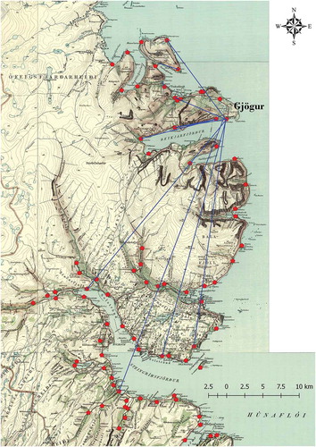
The fishing station Gjögur illustrates the way in which a typical farm primarily reliant on fishing operated in practice. Gjögur sits at the mouth of Reykjarfjörður, a fjord in the Strandir region of western Iceland, owned in equal measure by two individuals living nearby (see ). Valued at four hundredsFootnote8 (Magnússon and Vídalín Citation1913–1943, VII, p. 342), it was considerably below the traditional average value of 20 hundreds, and can therefore be considered to have had extremely poor agricultural prospects. The farm description bears this out; with a lease of 40 ells and no more than 15 sheep on the farm, the agricultural productivity was well below the national average. However, the farm generated considerable income from its ideally suited natural harbour: eight bothies were rented out to individuals in Strandir and Húnavatnssýsla to the east. The rental value for 2 of these was 15 ells each, and if that is an indication of the expected rental value of the other 6, the full rental income of the bothies would amount to 120, three times the value of the rent collected from the occupant of the farmstead itself.
Figure. 1. Lögbýli surveyed in Jarðabók. The area in white to the east shows areas recorded in manuscripts that were lost in the Copenhagen fire of 1728. Source: Maps produced using basemap data from Landmælingar Íslands.
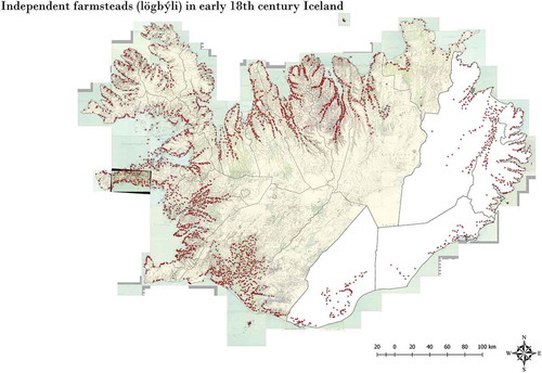
Figure. 2. The map shows the location of the owners of fishing bothies at the GJögur fishing station. Source: Maps produced using basemap data from Landmælingar Íslands.
The productive sphere of Gjögur, once the fishing station rentals are taken into account, is better represented as a distributed network than a productive unit delimited by its farmstead boundaries. The same observation can be made, to a greater or lesser degree, about every lögbýli in the country at the time: a collective of farms under the same owner can be argued to comprise a larger productive unit. Neighbouring farms supplemented the shortcomings of their respective lands by exchanging access to resources form partnerships of coupled subsistence; in short, networks of land use are formed by the interaction of people across time and space. These networks, then, carry across them causal influences that affect the behaviour of those entangled through them. This relational structure played an important role in guiding the database construction and digitisation, outlined below.
NETWORK MODELLING METHODOLOGY: FROM SOURCE TO LINE
The methodology employed to construct interpretive networks based on historical and archaeological material must be considered carefully. The biggest drawback to Ísleif’s data model is the focus on point data (the site) and its lack of affordances to encode relations between sites. As JÁM provides by far the most detailed account of land use across the island, it became the primary source for a database model centred on the relations between sites, ordered together at the primary farmstead level. Information about the easternmost farmsteads, whose records were lost in 1728, came from the earlier but much more sparse land census documents of 1696–1699 (catalogued in Lárusson Citation1967).
To ensure a direct link to the primary source, the entire work was digitised and the text divided based on farmstead location. The location is based on recordings in the field in cases where a farmstead had been surveyed; in other cases, the location of the farm mound was derived from either satellite imagery or maps, with roughly 40% derived from field survey and 60% from satellite imagery. The entire text is availableFootnote9 and searchable online using a REST API that provides a connection to the database, as well as a JQuery frontend. The relational database management system PostgreSQLFootnote10 was deemed particularly suitable to hold the data, both for its ability to model relations between data elements and for its considerable spatial capabilities.
The database schema centres on two concepts in the data. The first concept is the farm as a social unit, or lögbýli. This information includes its name, taxation value, ecclesiastical status, and so on. The second is the farm as dwelling, including information specific to a productive farm that falls under the farmstead as a social unit. This includes spatial location, occupation status, rent, livestock numbers, field productivity, and so on. A farmstead as a social unit does not necessarily have to include any farmstead dwellings;Footnote11 moreover, several farmstead dwellings can exist within the structure of a single löbgýli social unit (as primary farm and tenant farms). On the other hand, a farmstead dwelling can only be associated with a single löbgýli, although a single lögbýli may have several tenant farms that are not spatially contiguous with the primary landholding.
It is important to note, however, that the primary element in the database is neither spatial nor social, but temporal. Any reference to a known site in either the historic or archaeological record is treated as an event, with its own temporal properties. This approach is based on Lucas’ (Citation2010) distinction of traces and testimonies, where a testimony about a historical phenomenon is distinguished from the medium in which it resides – the trace. The relevance to the data structure is mostly in terms of metadata, but it is important to keep in mind that any testimony about a site in the database has its own trace, and it must be possible to distinguish between these. The JÁM census does provide a date and time for every farm description, and correspondingly the database treats these descriptions as individuated events in time. This allows for querying the database based on seasonality and the comparison of records from year to year, and has provided the grounds for studying annual phenomena that took place while the census was compiled, such as the response to the smallpox outbreak of 1907–1909 (Pálsson Citation2016).
Depending on the type of network to be investigated, PostGIS spatial functions were used to generate networks based on links either between or within given lögbýli units. Resource exchange and property ownership networks are an example of the former, while the latter includes links between primary and secondary farm dwellings, as well as links between the primary farm and controlled environmental resources. These are all recorded in JÁM, but it does not always provide information about how exactly these exchanges were transacted. The mapped networks should be thought of as frameworks for interpreting the past, but the veracity and the practical enactment of each and every network link is not possible to determine.
It is important to note that this methodology is not a network analysis per se, an initial mapping of relationships that can be studied further. In other words, the primary role of the database is not to provide network metrics, but to provide access to the combination of site survey and historical data embedded in interpreted networks of interactions. That does not preclude further analysis using SNA methods, or any other methods of network analysis, but, as I will address below, the data themselves suggest certain limitations to those methods.
NETWORK PERSPECTIVES ON EARLY 18TH-CENTURY ICELAND
The domestic economy of 18th-century Icelandic farmsteads appears to have relied on extensive networks of resource access and exchange, and these networks affected the movement of people and materials across the country. Some of these were stable, such as networks of primary and subsidiary farms, parishes and legal districts, as well as ecclesiastical and royal property networks. Others were more fluid, such as private property networks and resource exchange networks. This section identifies the networks apparent in the source material and investigates the implications of these networks for everyday life during the period.
ADMINISTRATIVE NETWORKS
The following section sketches out what could be called administrative networks detectable in JÁM and other contemporary historic sources. The purpose of the present study is not to analyse the character and influence of these networks in detail; nevertheless, I feel that a brief discussion of these, with examples of how they impacted daily life, provides further insight into the interdependence of farmsteads through complex social structures during the 18th century.
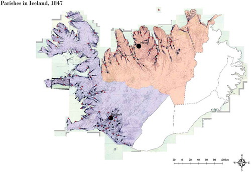
The first was the parish, an ecclesiastical social unit comprising roughly 320 parishes at the time, with the number of farms in the parish ranging from under half a dozen to 40, organised around a parish church. These church buildings were invariably situated on lögbýli farms, usually owned by the church (staðarkirkja) and occasionally owners of the farmstead itself (bændakirkja) (see Vésteinsson Citation1998, for a more detailed discussion of the difference between these two). Parish networks extend across the country and are highly modular clusters of parish farms oriented towards a centre, the parish church; in turn, the parish church was linked to one of the two episcopal seats depending on its location (see ).
. Parishes in Iceland, after Johnsen’s 1847 census. The blue area represents Skálholt’s bishopric, whereas the red shows Hólar’s. The red stars depict church-owned beneficia, while black stars depict privately owned parish churches. Source: Maps produced using basemap data from Landmælingar Íslands.
The parish network had clear implications for the interconnections between farm inhabitants. It was a network affecting flows of both people and materials: tithe was paid to the parish church in the form of agricultural produce, while the ecclesiastical calendar brought communities together. Páll Vídalín provides an example of the role of the church in socio-material flows in the diary he kept during the survey of Snæfellsnes. A virulent outbreak of smallpox began in the summer of 1707, and later that year Vídalín (Citation1904, p. 64) recounts that during Sunday services at the Staðarstaður church, the bodies of victims of the outbreak were brought to the church on six different occasions in less than two hours. In this case, the parish church provided not only an opportunity for news about the extent of the smallpox outbreak to spread, but likewise for the epidemic itself to exacerbate.
The second type of administrative network is that of the hreppur, a commune comprising roughly 20 farms. These communes were responsible for the provisioning of destitute individuals within the commune using a quarter of the tithe paid to parish churches, and so there was a material link between the two networks, but perfect overlap was not the custom. The management of shared uplands (afréttir) and commons (almenningar) was also organised by one or more hreppur. Just as the parish did, these communal networks affected the flow of humans and animals across the landscape. [AQ] Animal husbandry at the time, for instance, was a transhumant practice; sheep and in some cases other livestock were herded into the vast but sparsely vegetated uplands and left to graze there over the summer. The animals were then brought back to settlement in the autumn and sorted at sorting folds (réttir; see Sigurjónsson Citation1948, Aldred Citation2012). An example demonstrates how these places acted as nodes attracting the flows of humans, animals and material goods. Eggert Ólafsson and Bjarni Pálsson noted in the mid-18th century that one of these sorting folds, known as Hraundalsréttir in Borgarfjörður, not only provided the stage for the sorting of animals according to their owners, but was also the stage for ‘something resembling a market’ (Ólafsson and Pálsson Citation1974, p. 105). They witnessed individuals from fishing stations by the sea arriving with their goods, such as dried fish, fish oil and assorted foreign goods. The geographical unit of the hreppur, then, provides the basis for communal interactions and practices binding a community together and acting as a significant property of that community, while at the same time bringing in foreign trade. These lines of interaction, bringing humans, animals and goods across the landscape, all converge and bundle at the node – the sorting fold – if only for a matter of days out of the year.
The same can be said of the final two administrative networks, the assembly court and trade harbour networks, the first structured around four legislative courts across the nation (Karlsson Citation2000), the second a network of trading sites directing where foreign trade took place in Iceland (see ). Restrictions on where Icelanders could trade had a significant impact on the flow of material goods and, by extension, the lives of those producing and transporting goods. In certain cases, these restrictions were legislative. For instance, between 1684 and 1706, individuals were not permitted to trade outside their designated trade zone and the penalties for doing so could be very severe (Gunnarsson Citation1987, p. 81). In other cases, restrictions had more to do with distance and access between a farm and the designated trade harbours. The role of trading sites in the movement of material goods is a complex topic that cannot be adequately treated here, but see Róbertsdóttir (Citation2008) and Gunnarsson (Citation1987) for detailed accounts of trade sites during the early 18th century.
OWNERSHIP NETWORKS
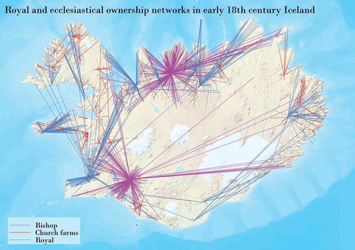
Medieval Icelandic society was characterised by tenancy. In 1695, 94% of all farms in the country were inhabited by tenants – people who did not own the property they inhabited (Guðmundsson Citation1985). Many of these individuals rented property owned by either the Danish crown, one of the two episcopal sees (Hólar in the north and Skálholt in the south), or a staðarkirkja. These ownership networks can be collectively termed state-level, distinguished from private-level ownership networks by certain characteristics. As shows, these networks could be very extensive but tended to be radial as there are relatively few state-level owners, and in the case of the royal and parish church networks, the average distance between the owner and tenant was relatively low in comparison to private networks. This is because of their historic roles as power centres with a large degree of control over their surrounding agricultural landscape (see ). The shortest distance is between churches on relatively small farms, reflecting the fact that these usually owned adjacent farmsteads, and rarely farms beyond their parishes. The same holds true for most church farms owned by the church itself, but the average is skewed as a handful of these had extensive networks, most notably Grenjaðarstaður and Múli in Þingeyjasýsla in the north-east of the country.
Table 2. Ownership categories.
Figure. 4. Royal and ecclesiastical ownership networks in early 18th-century Iceland. The bishoprics are shown in red, royal properties in blue and beneficia properties in orange. Source: Maps produced using basemap data from Landmælingar Íslands.
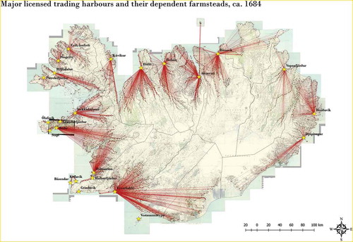
Figure. 5. Royal and ecclesiastical ownership networks in early 18th century Iceland. Source: Maps produced using basemap data from Landmælingar Íslands.
There are 1121 owners in the database, many of whom own more than one property. Practically every owner is associated with a farm, but only 439 of the 3508 farms were in self-ownership, where an occupant owned its farm fully or partially. The number of property relations – 4706 – exceeds the number of properties in the network as partial ownership is common.
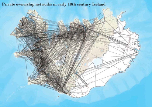
Private networks are significantly less legible as the ratio between owners and tenants was much lower than for state-level networks, and it was much more common for privately owned farms to have multiple different owners, often a result of split inheritance. The two bishoprics, for instance, owned a combined 658 farmsteads, while the 954 private owners had stakes in 2775 farmsteads. and show this structural difference between private and state ownership networks. The nodes in the state network are, for the most part, historic centres of power that had large and spatially contiguous landholdings shortly after the country was colonised and had been the largest property holders in the country for centuries leading up to the compiling of JÁM in 1702–1714. Many of the royal properties were once monastic, as the king claimed these during the dissolution of the monasteries during the 16th century. These continued to be administered from the old monastic centres by royal officials, seen as blue lines on . The property networks presented here exhibit scale-free characteristics (cf. Barabasi and Albert Citation1999); in other words, the distribution of node connectivity does not follow a normal distribution, but a power law.
Figure. 6. Private ownership networks in early 18th-century Iceland. Source: Maps produced using basemap data from Landmælingar Íslands.
Ownership networks inform land-use decisions. This becomes particularly apparent in the descriptions for many of the farms under state ownership. As noted above, a virulent strain of smallpox ravaged the country in the years 1707–1709 and is estimated to have led to the deaths of 25–33% of Iceland’s population (Steffensen Citation1975, pp. 296–297). The population collapse led to widespread abandonment of farmsteads and the lowering of rental values for tenants, and this adjustment is recorded for the counties surveyed after 1709, including roughly half of the county of Skagafjarðarsýsla, Eyjafjarðarsýsla and both Þingeyjarsýslur counties. Rents drop across the region, but there is a difference between the strategies of reduction for state-owned and privately owned properties. Rent was reduced by roughly 35% on average in the region, but the rent on a number of farmsteads under ecclesiastical and royal control was not adjusted, or lowered considerably less than the national average (Pálsson Citation2016). Instead, tenants on those farms were given rights to use land belonging to abandoned farmsteads (e.g. Magnússon and Vídalín Citation1913–1943, IX, p. 30). This, unsurprisingly, occurred primarily when a large landholder owned an abandoned farmstead near other tenants, but, given the spatial syntax of ecclesiastical and royal property networks, this was relatively common. The area Héraðsvötn shows several examples of this, where practically every unoccupied farm was owned by an ecclesiastical institution and practically every one of those was used to some capacity by tenants on farms owned by the same institution. In other words, large landholders can be seen to employ collective land-use strategies when they own several farmsteads in close proximity to one another (Pálsson Citation2016). It is the landscape, not the farmsteads themselves, that generates produce; the farmsteads act as nodes scattered across the landscape in networks of land use controlled by large landowners. The landscape is not abandoned as much, as its settlement structure depends on a dynamic between the availability of tenants, the expected rental rate and the value of the goods they produce.
Two further examples from the north of Iceland further illustrate the employment of collective land-use strategies in large ownership networks based on early 18th-century documents. The first is that of the church Vellir in Svarfaðadalur. Eleven of the 13 farmsteads owned by Vellir lie in Svarfaðadalur. Of those 11, 2 are purposefully kept vacant as they provide additional grazing lands to neighbouring farms owned by Vellir (Magnússon and Vídalín Citation1913–1943, X, pp. 78–90). Vellir, in this case, can make decisions that determine which of its farmsteads are leased to tenants based on what it considers beneficial to its entire ownership network rather than any one farm.
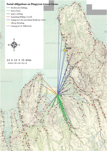
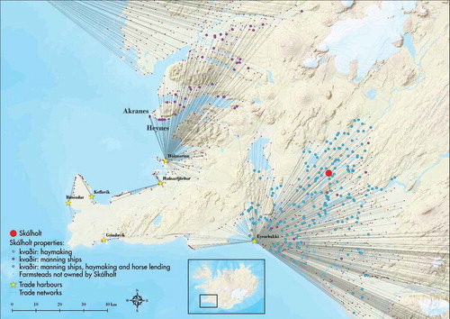
The second example shows the way in which large property networks could act as distributed economies of their central farmstead. Large landholders often imposed obligations on their tenant farmers beyond the two forms of payment, property rent (landskuld) and livestock lease (leigukúgildi). Known as kvaðir in the census records, these were particularly common for the tenant farms of ecclesiastical institutions and former monastic farms now controlled by the king (Júlíusson Citation1998). One of these is Þingeyrar, an historic power centre in Húnavatnssýsla under royal ownership in the early 18th century and administered by Lauritz Gottrup, himself a large landholder. When mapped, the obligations show a highly organised array of services that tenant farmers provide to the central farm based on the spatial syntax of Þingeyrar’s property network (see . Farmers living on Vatnsnes properties to the west were obliged to either man its fishing vessels or participate in sheep shearing, while those in Vatnsdalur to the south were obliged to work Þingeyrar’s hayfields at Hnaus, or to lend horses for the transport of trade goods to the trading site at Höfði (marked on with a yellow star). Tenants living close to the highly fecund Laxá river were obliged to fish in the river one day a year, while those living in Skagi were obliged to aid in the transport of trade goods from the Höfði trade site back to Þingeyrar. Not every farm had indentured obligations; for instance, only one of Þingeyrar’s five properties in Miðfjörður and Hrútafjörður to the south-west had an obligation imposed on them; the tenant on that farm, Reykir, was tasked with collecting and transporting the rent on those properties back to Þingeyrar. The arrangement responded to the affordances of the landscape, and can be argued to operate similarly to a single farmstead, one that uses different parts of its land for different purposes. The kvaðir system simply operates at a different scale.
Figure. 7. Obligations imposed by Þingeyrar and its administrator Lauritz Gottrup on tenant farmers. Source: Maps produced using basemap data from Landmælingar Íslands.
Understanding property networks provides a key insight into understanding the everyday life at any given farm, and the decisions taken on the use of land. While single landholders may have been primarily concerned with the utilisation of the resources on a single farm, larger landholders – particularly those who owned property in close proximity to one another – made, at times, decisions based on the well-being of a larger collective of farms. This lead to decisions made at the farm level that cannot be understood adequately by interpreting the site without its relational context.
RESOURCE NETWORKS
The second category of resource claims concerns the utilisation and transport of driftwood and stranded whales. Mapping these rights in the north of Iceland shows how extensive the spatial networks of resource utilisation are for these resources. Driftwood was essential for the construction of Icelandic turf houses, and whales provided food and fuel (Oddsson Citation[1638] 1917), and one can therefore argue that even single-farm subsistence agriculture relied on large, distributive networks.
shows claims on the driftwood and whales that would wash up on the shores of northern Iceland in the early 18th century. The claimants were invariably church farms and former monastic sites, comprising both local and regional magnates. Two church farms in the north-east serve as good examples of the former – Presthólar and Svalbarð, who both had claims on one-tenth of every whale that reached the shores of the farms in in their respective parishes. It is likely that claims of this type were established early on in Iceland’s history by farmsteads with considerable local properties and political power.
Figure. 8. Driftwood access rights to the shores of northern Iceland. Source: Maps produced using basemap data from Landmælingar Íslands.
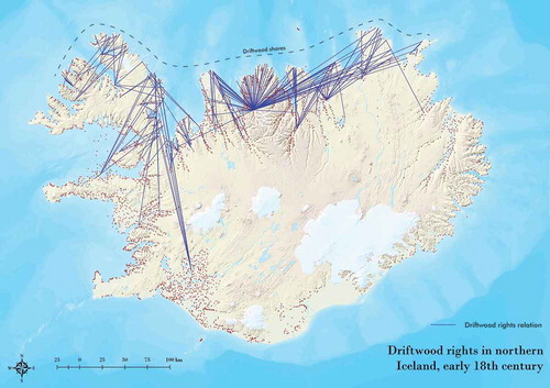
Figure. 9. The emergence of secondary properties in the management of Skálholt's episcopal estate. Source: Maps produced using basemap data from Landmælingar Íslands.
Regional magnates had extensive claims on farms that were often over 100 km away. These included many of the historic power centres in the country. These claims are often accompanied by kvaðir, the obligations on tenant farmers. Hólar, for instance, requires every one of its tenants on the northern Skagi peninsula to assist in the transportation of driftwood back to Hólar (Magnússon and Vídalín Citation1913–1943, IX).
DISCUSSION
This paper presents a method to contextualise site survey data by forging relations between major archaeological assemblages in the Icelandic landscape – the farmstead unit, or lögbýli. The issue, then, is whether this context increases understanding of these sites. First, many have suggested the existence of systems directing the movement of goods in medieval Iceland, but archaeologists have tended to rely on trade as a primary explanatory model (Carter Citation2015), although McGovern et al. (Citation2007) did suggest the existence of resource exchange networks in the Viking Age without elaborating on their character. As the analysis of JÁM presented here suggests, there were, in the 18th century, several overlapping and interdependent exchange networks influencing the movement of material and labour.
Specific examples in the census provide new ways of interpreting how the archaeological syntax of a lögbýli may have been influenced by its interactions with neighbouring lögbýli. The description of Þverá reads, for instance, that ‘the property has a meadow claim on the lands of Bót called Þverárteigur, delimited by an ancient boundary wall. In exchange, Bót either grazes pasture in a bit of land above Lækjardalur, or for one month in their land’ (Magnússon and Vídalín Citation1913–1943, XI, p. 246; translation by author). As the passage suggests, many of the resource exchanges making up the resource networks may have been materialised in some manner; for instance, by enclosures or by path systems linking remote resources back to the claimant farm. Moreover, these resource exchanges often resulted in place names reflecting the arrangement, such as a small patch called Þverárteigur (Þverá being the name of a nearby farm) in the land of Bót. The analysis presented here not only provides direct evidence for why place names on certain farmsteads bear the mark of neighbouring farms, or how certain resource claims were materialised, but also a model for explaining these occurrences more generally across the country. This is particularly notable as Þverá and Bót sit in a county with extensive earthworks from the Viking Age onwards, but the role of resource claims has not played a significant role in the interpretation of these structures (Einarsson Citation2015).
The JÁM interaction networks also problematise certain assumptions made by standard network analytical toolkits, such as SNA. Measures such as degree of centrality, transitivity and cohesion assume that links aggregate in consistent and predictable ways (Scott Citation2017). However, JÁM indicates that as farmsteads become more and more connected, they begin to exhibit novel characteristics, or what an assemblage theorist would refer to as emergent properties (DeLanda Citation2016). This is not a phenomenon that emerges predictably as connectivity reaches a certain stage. I will elaborate on this using two concepts from assemblage theory: downward-causing influences and emergent properties.
Analysing any one network presented in this paper using quantitative network analytical metrics would lead to unsatisfactory results. This is because it is clear that one network can influence another. Consider an example from Skagafjörður, northern Iceland. The lögbýli Hraun í Fljótum (Magnússon and Vídalín Citation1913–1943, IX, p. 339) does not have adequate turf, a vital building resource, and must collect turf from another farm. It does not trade with any of its neighbours, however. Instead, occupants travel south to Hamar, which according to the text is an arduous journey that takes over a week every year. The reason for this unlikely source of turf is not immediately obvious, but stems from the fact that both farms have the same owner, the bishopric at Hólar. It is likely that Hamrar was the closest farm owned by the bishop that had an abundance of turf. Whether or not that was the case, the broader point is that this particular resource exchange arrangement did not arise from a logical interaction between neighbours, but from the decision-making of a regional power, most likely benefiting the entire assemblage of properties under the bishopric, even if it led to a particularly cumbersome arrangement for the tenants at Hraun. In other words, the property network influences the resource network, and causes an interaction that is more triangular than linear.
JÁM contains many descriptions of what may be considered emergent properties (cf. DeLanda Citation2016). Skálholt, the bishopric in the south, provides a clear example. Skálholt was the largest landholder in the country at the time, and the majority of its properties are congregated in two clusters, one clustered around the bishopric itself, and the other in Borgarfjarðarsýsla county (see ). The farms in these two clusters are subject to different obligations. Whereas the farms in the Skálholt cluster deal directly with Skálholt in some way, the farms in Borgarfjarðarsýsla instead deal with the bishop’s representative at Heynes, one of its properties close to its fishery operation at Akranes. Those by Skálholt are subject to three obligations, namely the provision of manpower for grass cutting in Skálholt’s meadows, lending a horse to help bring goods to and from the market at Eyrarbakki, and a deckhand on one of its fishing boats. Those under the governance of Heynes need simply to meet the final of the three obligations. This suggests that the properties near Skálholt operate as part of a distributed economy centred on Skálholt. While the obligations on any one tenant were likely not significant – a few days’ labour out of the year – they add up to a significant number of labour hours for Skálholt, allowing the bishopric to undertake certain economic activities far beyond what its local workforce could have accomplished by bringing together workforces of potentially hundreds for the three undertakings related to the kvaðir obligations. Finally – and this may go some way to explaining why the two clusters act independently – they ultimately bring their produce to trade in separate harbours. The spatial character of Skálholt’s property network lends itself easily with this division into two clusters which are run, to some degree, independently. This is an emergent property of this particular form of complex connectivity.
Finally, I would like to discuss how lines of interaction become embodied and emplaced in the landscape. Consider a single line in the property network. This particular straight line indicates a relationship in space between a property and its proprietor. In this case, the owner is the royal crown, but the property is administered by a local official by the name of Sigurður Björnsson, who is tasked with collecting rent from several farmsteads clustered in Hrútafjörður, northern Iceland. As the owner in an agricultural society dominated by the propertied class (Júlíusson Citation2013), Sigurður Björnsson has the power to set the terms of rental payment. He is, however, based a considerable distance away from the farms he administers. The economy of 18th-century Iceland was still based on the exchanges of material goods; payment of rent by minted coin was rare, and so the payment involved material movement in one form or another. Live sheep were commonly used for payment, and the movement of this live fee was invariably the responsibility of the tenant. Jarðabók offers an insightful look into how these material exchanges took place. The description of rental payments for the farm Mýrar reads as follows (Magnússon and Vídalín Citation1913–1943, VIII, p. 24):
Rent 120 ells. Paid during the spring to Stafholt, or sometimes to Alþingi. For the first few years (of Sigurður Björnsson’s tenure) it was occasionally paid with livestock in the autumn to Hvítárvellir, where Sigurður lived at the time. … Proceeds from rented livestock paid in butter to Stafholt or to Hvammur in Norðurárdalur, or to a location within the county specified by Sigurður.
This is a material exchange involving not just point A and point B, but multiple interstitial points and places. This mode of rental payment is fluid and its circumstances have changed during Sigurður’s tenure, and one would imagine succeeding royal official arranging the payment differently. Walking this single line shows its dynamism, its roving qualities and the journeys it initiates, for the tenant and his or her animals as well as for the proprietor. While it might not be feasible to walk every line in a network, this single example serves as a reminder that every line in the network indicates a negotiated exchange of some manner between people and their animals, and that these interactions rarely proceed along straight lines. These pushes and pulls of agency, in a sense, are how networks ‘maintain their good shape’ (cf. DeLanda Citation2016, p. 30), but this shape is a knotted, tangled one.
As I have indicated above, reading any one line in isolation is problematic. In the above example, Sigurður Björnsson most likely requested the same arrangement of all its Hrútarfjörður-based tenants, and got around the difficulty in communicating with every single one of them by requesting that every tenant leave sheep at either Stafholt or Alþingi, at which point he presumably sent an agent to collect sheep from every tenant in one journey. Here, an emergent property arises from what one could call the parallelism of a particular array of lines, or the clustering of a particular set of nodes.
I would like to suggest that, alongside the two approaches to network theory that Mills (Citation2017, p. 382) identifies, namely node position and network structure, we should consider the line as a third modality. Network analysis, and in particular its visual practices, is a generative process of linework. The computed line, straight line, or the perfectly arced line that network analysis produces does not reflect how we think of the agency of interaction, or how we think of the fragmented archaeological and historical record. As such, we need to consider the role of the line in the context of the network; to trace it, to discover its knots and tangles. The computed line might simply be a graphical expression of the statement ‘X is related to Y’; the meaning of that must always be further explored, to echo process archaeology (Gosden and Malafouris Citation2015), in terms of lived experience, material flows and processes of becoming. If the line spans across a landscape, we need to walk it; if the line trickles through the archive, we need to read it. In doing so, the network becomes a bundle of storied lines, open to distant and close reading in equal measure (cf. Moretti Citation2013), and network analysis itself becomes a lineological practice (cf. Ingold Citation2015).
The majority of the interactions recorded in JÁM can be resolved by some type of material or human flow, such as rental payment, resource exchange, trade, or labour movement. In other words, every line is a path in a spatial network. The source material indicates that these paths do not always connect one node to another through something akin to a least cost path, however. At least not without a number of kinks in the road as materials travel from one farmstead to another. It is helpful to consider these lines as transaction paths, a concept which Tsirogiannis and Tsirogiannis (Citation2016) have used to model illegal antiquities trade. While their topological algorithm is unsuitable to the issue presented in this paper, namely the analysis of emergent ways in which a particular network link is transacted based on how it may be influenced by other links and other networks, I suggest that thinking about how links are likely to have been transacted is a productive complement to the analysis of link aggregations (using, for instance, SNA) with link articulations, using analytical techniques based on historical precedence, landscape analysis, and intuition. As the above examples suggest, such a lineological analysis may lead to lines that wander well away from the initial pair of nodes it notionally connects.
The JÁM census consistently shows that high connectivity results in the emergence of mechanisms to handle the flow of materials and goods. These are hard to predict, as they depend on solutions that are specific to a given set of farm interactions. Network metrics based on cumulative metrics may be able to identify highly connected farmsteads in the data-set, but they do not offer any tools to predict how those degrees of connectivity begin to break down as site-to-site connections become material paths of transaction. These considerations call for methodological advances in archaeological network analysis that go beyond the scope of this study, but are the subject of future work.
The purpose of this paper is not to offer thorough quantitative analysis of networks derived from historic records of early 18th-century Iceland, but to identify and characterise these networks of interaction, their implications and relation to archaeological survey. What emerges is a highly interconnected society, described in a text where the connections are clearly central to the description of the farmsteads. Furthermore, these arrays of connections generate emergent properties that cannot be adequately understood using a single-site approach as decisions made at the farm level are influenced by the relations binding the farmstead into components of larger wholes, such as a parish, property network, or a participant in resource exchange. Any farmstead is a component in a set of sets, an assemblage of assemblages, a network of networks.
Acknowledgements
I am grateful to several colleagues at Umea University, the North Atlantic Biocultural Organization and Fornleifastofnun Íslands for productive discussions through the years. I especially thank Orri Vésteinsson, Oscar Aldred, Howell Roberts, Adolf Friðriksson, Birna Lárusdóttir, Phil Buckland, Gavin Lucas, Elín Hreiðarsdóttir, Emily Lethbridge Rachel Opitz, Árni Daníel Júlíusson, Tom McGovern, Colleen Strawhacker and Megan Hicks.
Notes
1 The Institute of Archaeology, Iceland.
3 The Land Census by Árni Magnússon and Páll Vídalín.
4 Knappett (Citation2013) reviews the history of network approaches in archaeology and reaches a similar conclusion, noting the lack of network analysis in processual archaeology.
5 Roughly 4000 primary farms, 40,000–60,000 inhabitants on a 101 km2 land mass (Karlsson Citation2000).
6 ‘The correct and complete land census’.
7 Ibid.
8 A ‘hundred’ was a measurement amounting to 120 ells of wool. See Júlíusson (2013) for a more detailed discussion of the valuation system.
11 This rarely occurs, but as the ownership of a lögbýli confers certain benefits, such as a vote in regional elections, there are instances where a farmstead exists in name only, even if it has not been occupied for several centuries.
12 Tithe was traditionally divided in four, with one part going to the bishop, one to the parish priest, one to support paupers in the parish, and a final one to maintain the church property.
Related Research Data
References
- Aldred, O., 2012. Mobile communities: the gathering and sorting of sheep in Skútustaðarhreppur, Northeast Iceland. International Journal of Historical Archaeology, 16 (3), 488–508. doi:10.1007/s10761-012-0187-9
- Amorosi, T., et al., 1997. Raiding the landscape: human impact in the Scandinavian North Atlantic. Human Ecology, 25 (3), 491–518. doi:10.1023/A:1021879727837
- Barabási, A.L., 2003. Linked: how everything is connected to everything else and what it means for business, science, and everyday life. New York: Plume.
- Barabasi, A.L., and Albert, R., 1999. Emergence of scaling in random networks. Science, 286 (5439), 509–512. doi:10.1126/science.286.5439.509
- Barnes, J.A., and Harary, F., 1983. Graph-theory in network analysis. Social Networks, 5 (2), 235–244. doi:10.1016/0378-8733(83)90026-6
- Bentley, R.A., and Maschner, H.D., 2008. Complexity theory. Lanham: AltaMira Press.
- Bevan, A., 2015. The data deluge. Antiquity, 89 (348), 1473–1484. doi:10.15184/aqy.2015.102
- Borgatti, S., Everett, M., and Johnson, J., 2018. Analyzing social networks. London: Sage.
- Broodbank, C., 1993. Ulysses without sails: trade, distance, knowledge and power in the early Cyclades. World Archaeology, 24 (3), 315–331. doi:10.1080/00438243.1993.9980211
- Brughmans, T., 2010. Connecting the dots: towards archaeological network analysis. Oxford Journal of Archaeology, 29 (3), 277–303. doi:10.1111/j.1468-0092.2010.00349.x
- Brughmans, T., 2013. Thinking through networks: a review of formal network methods in archaeology. Journal of Archaeological Method and Theory, 20, 623–662. doi:10.1007/s10816-012-9133-8
- Buckland, P.C., et al., 1996. Bioarchaeological and climatological evidence for the fate of Norse farmers in medieval Greenland. Antiquity, 70 (267), 88–96. doi:10.1017/S0003598X00082910
- Carter, T., 2015. Iceland’s networked society: revealing how the global affairs of the viking age created new forms of social complexity. Leiden: Brill.
- Christaller, W., and Baskin, C.W., 1966. Central places in southern Germany. Englewood Cliffs: Prentice-Hall.
- Cline, D.H., and Cline, E.H., 2015. Text messages, tablets, and social networks: the “small world” of the Amarna Letters. In: J. Myrnarova, et. al., eds. Crossroads II. Proceedings of an International Conference on the Relations of Egypt and the Near East in the Bronze Age. Prague: University in Prague Pres.
- DeLanda, M., 2006. A new philosophy of society: assemblage theory and social complexity. New York: Bloomsbury.
- DeLanda, M., 2016. Assemblage theory. Edinburgh: Edinburgh University Press.
- Deleuze, G., 1994. Difference and repetition. New York: Columbia University Press.
- Deleuze, G., and Guattari, F., 1987. A thousand plateaus: capitalism and schizophrenia. Minneapolis: University of Minnesota Press.
- Dugmore, A.J., et al., 2005. The Norse landnám on the North Atlantic islands: an environmental impact assessment. Polar Record, 41 (1), 21–37. doi:10.1017/S0032247404003985
- Dugmore, A.J., et al., 2007. The role of climate in settlement and landscape change in the North Atlantic islands: an assessment of cumulative deviations in high-resolution proxy climate records. Human Ecology, 35 (2), 169–178. doi:10.1007/s10745-006-9051-z
- Dugmore, A.J., et al., 2012. Cultural adaptation, compounding vulnerabilities and conjunctures in Norse Greenland. Proceedings of the National Academy of Sciences of the United States of America, 109 (10), 3658–3663. doi:10.1073/pnas.1115292109
- Düring, M., 2016. How reliable are centrality measures for data collected from fragmentary and heterogeneous historical sources? A case study. In: T. Brughmans, A. Collar, and F. Coward, eds. The connected past. Oxford University Press.
- Earley-Spadoni, T., 2015. Landscapes of warfare: intervisibility analysis of early iron and urartian fire beacon stations (Armenia). Journal of Archaeological Science Reports, 3, 22–30. doi:10.1016/j.jasrep.2015.05.008
- Eggertsson, T., 1996. No experiments, monumental disasters: why it took a thousand years to develop a specialized fishing industry in Iceland. Journal of Economic Behavior and Organization, 30 (1), 1–23. doi:10.1016/S0167-2681(96)00839-6
- Einarsson, Á., 2015. Viking age fences and early settlement dynamics in Iceland. Journal of the North Atlantic, (27), 1–21. doi:10.3721/037.006.2703
- Emirbayer, M., and Goodwin, J., 1994. Network analysis, culture, and the problem of agency. American Journal of Sociology, 99 (6), 1411–1454. doi:10.1086/230450
- Frei, K.M., et al., 2015. Was it for walrus? Viking Age settlement and medieval walrus ivory trade in Iceland and Greenland. World Archaeology, 47 (3), 439–466. doi:10.1080/00438243.2015.1025912
- Friðriksson, A., and Vésteinsson, O., 1998. Ísleif: a database of archaeological sites in Iceland. Archaeologia Islandica, 1 (1), 45–47.
- Gosden, C., and Malafouris, L., 2015. Process archaeology (P-Arch). World Archaeology, 47 (5), 701–717. doi:10.1080/00438243.2015.1078741
- Graham, S., 2006. Networks, agent-based models and the Antonine itineraries: implications for Roman archaeology. Journal of Mediterranean Archaeology, 19 (1), 45. doi:10.1558/jmea.2006.19.1.45
- Granovetter, M.S., 1973. The strength of weak ties. American Journal of Sociology, 78 (6), 1360–1380. doi:10.1086/225469
- Guðmundsson, B., 1985. Efnamenn og eignir þeirra um 1700. Reykjavík: Ritsafn Sagnfræðistofnunar.
- Guðmundsson, G.F., 1993. Jarðabréf frá 16. og 17. öld: útdrættir. Copenhagen: Hið íslenska fræðafélag í Kaupmannahöfn.
- Gunnarsson, G., 1987. Upp er boðið Ísaland: einokunarverslun og íslenskt samfélag 1602-1787. Reykjavík: Örn og örlygur.
- Harary, F., 1960. Some historical and intuitive aspects of graph theory. Siam Review, 2 (2), 123–131. doi:10.1137/1002023
- Hunt, T.L., 1988. Graph theoretic network models for Lapita exchange: a trial application. Archaeology of the Lapita cultural complex: a critical review. Thomas Burke Memorial Washington State Museum Research Reports, (5), 135–155.
- Ingold, T., 2008. Lines: a brief history. London: Routledge.
- Ingold, T., 2015. The life of lines. London: Routledge.
- Johnsen, J., 1847. Jarðatal á Íslandi. Copenhagen: J. Johnsen, printed by S. Trier.
- Jónsson, T., and Júlíusson, Á.D., 2013. Landbúnaðarsaga íslands. Reykjavík: Forlagið.
- Júlíusson, Á.D., 1997. Bønder i pestens tid: Landbrug, godsdrift og social conflikt i semiddelalderens islanske bondesamfund. Thesis (PhD). University of Copenhagen.
- Júlíusson, Á.D., 1998. Kvaðirnar Kvaddar, Þriðja Íslenska söguþingið. Reykjavík: Sögufélagið.
- Karlsson, G., 2000. Iceland’s 1100 years: history of a marginal society. Reykjavík: Mál og Menning.
- Knappett, C., 2011. An archaeology of interaction: network perspectives on material culture and society. Oxford: Oxford University Press.
- Knappett, C., ed. 2013. Network analysis in archaeology. Oxford: Oxford University Press.
- Knox, H., Savage, M., and Harvey, P., 2006. Social networks and the study of relations: networks as method, metaphor and form. Economy and Society, 35 (1), 113–140. doi:10.1080/03085140500465899
- Kristjánsson, A., and Gunnlaugsson, G.Á., 1990. Félags- og hagþróun á Íslandi á fyrri hluta 19. aldar. Saga, 28, 7–62.
- Larson, K.A., 2013. A network approach to hellenistic sculptural production. Journal of Mediterranean Archaeology, 26 (2), 235–260. doi:10.1558/jmea.v26i2.235
- Lárusson, B., 1967. The old Icelandic land registers. Malmö: Gleerup.
- Latour, B., 2005. Reassembling the social: an introduction to actor-network theory.Oxford: Oxford University Press.
- Law, J., 1992. Notes on the theory of the actor-network: ordering, strategy, and heterogeneity. Systemic Practice and Action Research, 5 (4), 379–393.
- Lawson, I.T., et al., 2005. Historical ecology on Sandoy, Faroe Islands: Palaeoenvironmental and archaeological perspectives. Human Ecology, 33 (5), 651–684. doi:10.1007/s10745-005-7681-1
- Lefebvre, H., 1991. The production of space. Malden: Blackwell.
- Lemercier, C., 2015. Formal network methods in history: why and how? In G. Fertig, ed., Social networks, political institutions and rural societies. Turnhout: Brepols, 281–310.
- Lucas, G., 2010. Time and the archaeological archive. Rethinking History, 14 (3), 343–359. doi:10.1080/13642529.2010.482789
- Lucas, G., and Edwald, Á., 2015. Capitalism and mobility in the North Atlantic. In: M.P. Leone and J.E. Knauf, eds. Historical archaeologies of capitalism. London: Springer, 227–247.
- Magnússon, Á., 1916. Embedsskrivelser og andre offenlige aktstykker, utgivet af Kr. Kålund. Copenhagen: Gyldendal.
- Magnússon, Á., and Vídalín, P., 1913–1943. Jarðabók Árna Magnússonar og Páls Vídalín. Copenhagen: Hið íslenzka fræðafjelag.
- Massey, D., 2005. for space. London: Sage.
- McGovern, T., et al., 2007. Landscapes of settlement in Northern Iceland; Historical ecology of human impact and climate fluctuation of the millennial scale. American Anthropologist, 109 (1), 27–51. doi:10.1525/aa.2007.109.1.27
- Mills, B.J., 2017. Social network analysis in archaeology. Annual Review of Anthropology, 46, 379–397. doi:10.1146/annurev-anthro-102116-041423
- Moretti, F., 2013. Distant reading. New York: Verso Books.
- Munson, J., et al., 2014. Classic Maya bloodletting and the cultural evolution of religious rituals: quantifying patterns of variation in hieroglyphic texts. Plos One, 9 (9). doi:10.1371/journal.pone.0107982
- Newman, M.E.J., 2010. Networks: an introduction. Oxford: Oxford University Press.
- Oddsson, G., [1638] 1917. Annalium in Islandia farrago and De mirabilibus Islandiae. Ithaca: Cornell University Library.
- Ólafsson, E., and Pálsson, B., 1974. Ferðabók Eggerts Ólafssonar og Bjarna Pálssonar um ferðir þeirra á Íslandi árin 1752–1757. Reykjavík: Örn og Örlygur.
- Pálsson, G., 2016. Coping with Disaster: the impact of Stórabóla on abandonment, reoccupation and land use in early 18th century Iceland. In: Digital humanities in the Nordic Countries, 15–17 March 2016. University of Oslo Library.
- Prignano, L., Morer, I., and Diaz-Guilera, A., 2017. Wiring the past: a network science perspective on the challenge of archeological similarity networks. Frontiers in Digital Humanities, 4 (13). doi:10.3389/fdigh.2017.00013
- Róbertsdóttir, H., 2008. Wool and society: manufacturing policy, economic thought, and local production in 18th-century Iceland. Lund: Lund University Press.
- Rollinger, C., et al., 2017. Editor’s introduction. Journal of Historical Network Research, 1, i–vii.
- Scott, J., 2017. Social network analysis. London: Sage.
- Sigurjónsson, B., 1948. Göngur og réttir. Akureyri: Norðri.
- Sindbæk, S.M., 2007a. Networks and nodal points: the emergence of towns in early Viking Age Scandinavia. Antiquity, 81 (311), 119–132. doi:10.1017/S0003598X00094886
- Sindbæk, S.M., 2007b. The small world of the Vikings: networks in early medieval communication and exchange. Norwegian Archaeological Review, 40 (1), 59–74. doi:10.1080/00293650701327619
- Steffensen, J., 1975. Menning og meinsemdir. Reykjavík: Sögufélag.
- Þorláksson, H., 1991. Sauðafell. Um leiðir og völd í Dölum við lok þjóðveldis. In: G. Karlsson and H. Þorláksson, eds. Yfir Íslandsála. Afmælisrit til heiðurs Magnúsi Stefánssyni. Reykjavík: Háskólaútgáfan, 95–110.
- Þorsteinsson, H., et al., 1922. Annálar 1400–1800. Reykjavík: Hið íslenzka bókmenntafélag.
- Tsirogiannis, C., and Tsirogiannis, C., 2016. Uncovering the hidden routes: algorithms for identifying paths and missing links in trade networks. In: T. Brughmans, A. Collar, and F. Coward, eds. The connected past. Oxford University Press.
- Tuan, Y.-F., 2001. Space and place: the perspective of experience. Minneapolis: University of Minnesota Press.
- van Steen, M., 2010. Graph theory and complex networks: an introduction. Amsterdam: Marten van Steen.
- Vésteinsson, O., 1998. The christianization of Iceland. Priests, power and social change 1000–1300. Oxford: Oxford University Press.
- Vésteinsson, O., McGovern, T., and Keller, C., 2002. Enduring impacts: social and environmental aspects of viking age settlement in Iceland and Greenland. Archaeologica Islandica, 2, 98–136.
- Vídalín, P., 1904. Aldarfarsbók Páls lögmanns Vídalíns, 1700–1709. Reykjavík: Aldar-Prentsmiðja.
- Watts, D.J., and Strogatz, S.H., 1998. Collective dynamics of ‘small-world’ networks. Nature, 393 (6684), 440–442. doi:10.1038/30918
- Whatmore, S., 2002. Hybrid geographies: natures, cultures, spaces. London: Sage.
- White, H.C., 2008. Identity and control: how social formations emerge. Princeton: Princeton University Press.