
Abstract
Major changes in the archaeological material in Rogaland, southwestern Norway, from the mid-6th century AD have been interpreted as a population decline and an economic recession connected to the 6th century crisis. This event is known from historical and archaeological sources in continental Europe and has recently gained much attention in the Scandinavian archaeological debate. Sudden climate change, pandemic and collapsed trading networks likely induced new conditions, which would have had a major impact on the society in southwestern Norway. This paper uses plant-macrofossil data, supplemented by zooarchaeological data, and radiocarbon dates, from two archaeological sites with different prerequisites and trajectories, to reconstruct agricultural development. Based on this reconstruction, it explores agricultural resilience in connection with the 6th century crisis and investigates the merits of various agricultural strategies and adaptations. The macrofossil data reveals a change in crop composition, with a temporary introduction of rye at one of the sites, suggesting an adjustment to new circumstances. The studied sites display different subsistence strategies based on local conditions, and the data suggests complete abandonment of the site that probably depended on trade, while the people living at the more self-sufficient site were able to adapt their agriculture and survive the crisis.
INTRODUCTION
In the mid-6th century AD, a distinct change in material culture and settlement patterns can be observed in the archaeological material from southwestern Norway. Widespread farm abandonment, suggested by decreasing numbers of settlements and finds (Petersen Citation1933, Citation1936, Myhre Citation1972, Citation1991, p. 15–17, Citation2002, pp. 170–173, Vetrhus Citation2017), coincides with a steep decline in specialized ceramic craft and fine metalwork (Fredriksen et al. Citation2014, Rødsrud Citation2016). A similar pattern has been observed in other places in Scandinavia, indicating that decline and abandonment was a common development in this region (Näsman and Lund Citation1988, Göthberg Citation2007, Herschend Citation2009, Zachrison et al. Citation2011, Löwenborg Citation2012, Svedjemo Citation2014, Grønnesby and Heen-Pettersen Citation2015, Gjerpe Citation2017, Solheim and Iversen Citation2019).
Although many factors could have contributed to the observed changes in the 6th century, they coincide with the cold period following the dust veil in AD 536, leading several researchers to identify the event as the mythological Fimbulwinter (Axboe Citation1999, Gräslund Citation2007, Gräslund and Price Citation2012, Price and Gräslund Citation2015, pp. 123–127). The ensuing Justinian Plague pandemic in southern and central Europe started in AD 542 and devastated the European population over a period of 200 years (Little Citation2007, Stathakopoulos Citation2007, Wagner et al. Citation2014, Findlay and Lundahl Citation2017). A potential spread to Scandinavia has been discussed as another possible factor behind the crisis (Gräslund Citation1973, Myhre Citation2002, pp. 172–173, Pedersen and Widgren Citation1998, p. 311). Recent research on the 6th century cooling (Sigl et al. Citation2015, Büntgen et al. Citation2016, Toohey et al. Citation2016), as well as on the Justinian Plague (Harbeck et al. Citation2013, Wagner et al. Citation2014), has contributed to a renewed interest in this period (Price and Gräslund Citation2015, Stamnes Citation2016, Gundersen Citation2019, Solheim and Iversen Citation2019).
Resilience and vulnerability are core concepts in exploring the underlying processes that affected the development of the 6th century society. A resilient society is one that can adapt to change and has diversity and flexibility that can be utilized as a response to disturbance (Redman and Kinzig Citation2003, Redman Citation2005, p. 72). Within risk and disaster research, root cause analysis is used to systematically identify the vulnerability in a system and to find preventive measures to counter the effects of a calamity (Blaikie et al. Citation1994, Oliver-Smith et al. Citation2017). For the 6th century society in Norway, Gundersen (Citation2019) outlines three domains of root causes that are crucial for understanding the resilience and vulnerability of the society: political robustness, economic robustness, and productivity robustness. This study concerns productivity robustness.
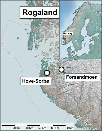
Changing climate and population decrease due to starvation or disease would have altered the conditions for agriculture in southwestern Norway, which may have forced the population to adopt new strategies for both crop cultivation and animal husbandry. We investigate agricultural development before, during and after the changes observed in the mid-6th century AD by focusing on two case studies: Hove-Sørbø and Forsandmoen (24 km apart) in southwestern Norway (). These sites are particularly apt for this study since they both have long settlement histories that span the centuries leading up to the crisis, as well as the time of the events and their aftermath, and are well documented by archaeological excavations during the last decades (Bjørdal et al., Citation2022, Løken Citation2020).
Fig. 1. Hove-Sørbø is located on fertile farmland in the western part of Rogaland, while Forsandmoen is situated in the mountainous region in the eastern part of the county.
The archaeobotanical data from these excavations, supplemented with zooarchaeological data and a compilation of radiocarbon dates, are used to discuss the local agriculture and settlement development. Their differing geographical and environmental settings, settlement structure and development provide a basis for discussing the resilience of various agricultural and broad-spectrum economies. The aims of this study are 1) to reconstruct variations in settlement intensity and agricultural practices from the 5th to the 11th century AD at Hove-Sørbø and Forsandmoen, and 2) to analyse the resilience of the two sites and explore how different strategies may have been adopted for dealing with new climatic and social conditions during the 6th century crisis.
SITES
Hove-Sørbø
The archaeological site of Hove-Sørbø is located in the southern part of Sandnes municipality, Rogaland County (). The name Hove suggests that it was a cult site, with Hov in Old Norse meaning temple or cult building (Særheim Citation2007, pp. 107, 228). The site is situated on fertile arable land, between a low-lying coastal area to the west and hilly areas to the east. The coastal area was almost treeless and used for agriculture in the Iron Age (Prøsch-Danielsen and Simonsen Citation2000), and game would have been sparse in the area. The sea was easily accessible, with Gandsfjord around 2 km north of the site. From the fjord, the main road leading south passed by Hove and gave it a strategic location as well as providing good communication routes and access to marine resources (Reiersen Citation2017, p. 262). The excavated area is situated on top of a ridge that stretches between the modern farms Hove and Sørbø, which are known to be at least a couple of hundred years old (Myhre Citation1972).
Fig. 2. Overview of the main settlement at Hove-Sørbø and the surrounding landscape during the excavation in 2011. The photo is taken towards east.
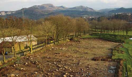
Hove-Sørbø was excavated in 2011–2012 covering an area of 22,000 m2. The excavation revealed human activity on the site starting in the Late Neolithic. In the main activity area, there were houses (in this paper referring to both dwellings and other structures interpreted as buildings) from the 13th century BC to the 7th century AD, and around 200 metres to the south-southwestern, a separate farm was inhabited from the 5th to 8th century BC. The main settlement area expanded in the 1st century BC and 22 houses were recorded from the 1st–5th century AD (Early Iron Age). From around AD 300–550, new, larger houses were built and a road from the east-southest, leading to a sunken courtyard next to the largest house, was established. The large size of the houses suggests that the main settlement was a magnate farm and may have been a regional centre, run by a local chieftain (Bjørdal Citation2014, Citation2016).
A recent study suggests that the largest longhouse at the site, and a connected outbuilding, may have been the core of a cluster of cult houses (Reiersen Citation2017, p. 266). The importance of the settlement is further demonstrated by several large Iron Age grave mounds in the area. Prestigious objects recovered from them indicate that the area was a centre of religious, social and political influence (Bjørdal Citation2014). Among the artefacts are a golden finger ring and a serpent-head arm ring, both status symbols indicative of a regional centre. Roman import finds, such as a Hemmoor bucket, found in one of the grave mounds at the site, illustrate that there were established trading networks with the continent (Myhre Citation1972, pp. 131–132, Reiersen Citation2011).
From around AD 550, the activity in the main area decreased and the large houses disappeared, while several houses were built in the south-southwestern settlement area. In the 9th–11th century (Viking Period), an area around 150 metres north-northeast of the main area was settled for the first time while the south-southwestern area was still active. The main settlement area was seemingly abandoned in the 8th century, but since the area borders the modern farmyard, where no excavations have been carried out, a continuation of the settlement cannot be excluded.
Forsandmoen
Forsandmoen is located in the SW part of Forsand municipality in Rogaland County, where the fjords Høgsfjorden and Lysefjorden meet (). The name Forsandmoen means the sandy plain by the river mouth, but an older name for the village is Landa, simply meaning the land (Særheim Citation2007, pp. 68, 143). The site is situated on poor agricultural soil, on a flat area made up of glaciofluvial deposits. It is surrounded by steep mountains (up to 600 metres), which could have provided mountain grazing, hunting and other outfield resources to the settlement. Between the flat area and the mountains to the south, a river meanders through a deep valley, running towards the fjord, which is about 1.7 km west of the site. Today, the landscape has been remodelled due to industrial extraction of sand and gravel from the glaciofluvial deposits. The settlement was first established, in the Early Bronze Age, in the northeastern part of Forsandmoen, which has the most favourable local climate. It is protected from the wind by the mountains and receives the most sunlight (Løken Citation2020, Dahl et al. Citation2019).
Fig. 3. Overview of Forsandmoen and the surrounding landscape from 2007. The photo is taken towards northeast from a near by mountain top by Theo Gil. The water is lake Haukalivatnet.
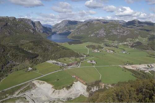
Archaeological excavations were carried out mainly during the 1980s, but smaller excavations also took place in 2007, 2017 and 2020. In total, 85,000 m2 have been excavated. The results from these excavations show that Forsandmoen was first settled in the Early Bronze Age (c. 1500 BC) when a few farms were established in what would become the main settlement area towards the northeast. During the Late Bronze Age (1200–500 BC) and Early Iron Age (500 BC–550 AD), the settlement area expanded towards the west and south. In the Early Iron Age, the farms were organized in rows, on similarly sized plots, and new houses replaced the old ones at the same location. The farms probably worked as independent units, while a common system of cattle paths leading out from the village, suggests that the surrounding land was used collectively (Dahl Citation2008, Dahl et al. Citation2019, Løken Citation2020).
A hardened layer of soil, an iron pan, further worsened the soil conditions at Forsandmoen. The iron pan probably developed during the last centuries of settlement and could have been caused by deteriorating climate and overutilization of the soil, resulting in poor conditions for agriculture (Løken Citation2020). However, the outfield areas around Forsandmoen are rich, and resources such as timber, iron or fur could have been traded in exchange for additional food to support the population (Løken Citation1984, Citation2020, Citation2006, Citation2020, Løken et al. Citation1992, Dahl Citation2021).
The settlement at Forsandmoen reached its maximum size in the Late Roman Iron Age and the Migration Period with 19–20 farms, estimated as housing at least 200 people and with 40–50 hectares of arable land and pasture (Løken Citation1987a, Citation2020, Citation2001). However, the latest excavation in 2020, during which several houses were found in an area previously thought to have been used for grazing, indicates that the settlement might have been even larger (Dahl Citation2021, Dahl et al. Citation2021). In the 6th and early 7th century, the number of farms decreased before disappearing completely around AD 700. A few radiocarbon dates indicate human activity in the area during the Viking Period, but no clear house remains have been discovered (Dahl et al. Citation2019).
MATERIALS AND METHODS
Plant-macrofossils
This study presents plant-macrofossil data from features associated with house remains at Hove-Sørbø and Forsandmoen, dated from AD 400 to 1050. This time span was chosen to investigate the agricultural development before, during and after the 6th century crisis. The results are presented chronologically, divided into three archaeological periods: the Migration Period (AD 400–550), the Merovingian Period (AD 550–800) and the Viking Period (AD 800–1050). Houses with reliable radiocarbon dates from both the 4th and 5th centuries were also included in the material from the Migration Period, as the houses often had a long lifespan and there were no clear distinctions between periods.
During the excavation at Hove-Sørbø, samples for macrofossil analysis were collected from 12 houses. From archaeological features in these houses, such as hearths, postholes and pits (Bjørdal et al. Citationforthcoming), a total of 129 soil samples were collected and analysed. The sample volumes varied from 0.3 to 6.7 litres (mean 3.9 litres). From all three excavations at Forsandmoen, a total of 233 samples from 16 houses were analysed for this study. The samples were taken from hearths, postholes, pits and ditches/beam slots, and volumes varied from 0.2 to 10 litres (mean 5.2 litres) (Løken Citation1983, Citation1984, Citation1987a, Citation1987b, Citation1988, Citation2020, Citation1998a, Citation1998b, Citation1999, Citation2001, Citation2006, Løken et al. Citation1992, Dahl Citation2008, Dahl et al. Citation2019). Part of the macrofossil material retrieved in the 1980s was analysed in connection with the excavations, and interpretations of these results have been published in several papers with a focus on Bronze Age agriculture (Bakkevig Citation1991, Citation1992, Citation1995, Citation1998). However, except for a few houses that were re-analysed for a research project (Prøsch-Danielsen and Soltvedt Citation2011), no raw data was available, and consequently the material was analysed again for this study.
All plant-macrofossil samples were floated and the organic material was collected in a 0.5 mm mesh sieve. The floated and dried samples from the Forsandmoen excavations of the 1980s and 2007 were stored in the museum archive and were re-examined together with the samples from 2017, in preparation for this study. The samples were analysed using a stereo microscope with 7.5x to 112.5x magnification. The identification was aided by the reference collection at the Museum of Archaeology, University of Stavanger, and relevant literature (Berggren Citation1969, Citation1981, Korsmo et al. Citation1981, Anderberg Citation1994, Cappers et al. Citation2006, Jacomet Citation2006, Mossberg and Stenberg Citation2012).
Charred seeds were the main macrofossil component in the samples from both Hove-Sørbø and Forsandmoen. Uncharred seeds were present but are not included in this study due to their uncertain age. They normally decompose quickly and are therefore likely to be recent. Seeds with uncertain identification (marked cf. during the analysis) were placed in the Indeterminata category. Many of the samples from the 1980s did not have a recorded volume, and hence, a mean volume (based on samples with recorded volumes) for these samples was used. The division into ecological groups was based on Nordic floras and botanical literature (Korsmo et al. Citation1981, Fremstad Citation1997, Lid and Lid Citation2005, Mossberg and Stenberg Citation2012). This division is somewhat arbitrary as plants can be associated with several different groups.
Radiocarbon Dating
All available 14C dates from the sites, 130 samples from Hove-Sørbø and 311 from Forsandmoen, were compiled for this study. Mainly charcoal fragments and cereal grains were dated (electronic supplementary). The radiocarbon dates were calibrated in OxCal (Reimer et al. Citation2013) and subsequently compiled using the summed probability function (Ramsey Citation2017). The age for each house was estimated by taking the mean of all dates (mid-point after 2σ calibration) associated with that house. These ‘house ages’ were used in all further analyses. This method narrows the age range of samples, sometimes related to a wide distribution of radiocarbon dates, which is a simplification but a necessary way to achieve an overview of the data.
Zooarchaeological Material
The faunal remains from Hove-Sørbø and Forsandmoen were retrieved from features at the settlements, such as pits and postholes. The remains are poorly preserved and heavily fragmented, which makes them hard to identify. Faunal remains from settlement sites are most often leftovers from meals, where bones are remains of either boiled or roasted meat (Lyman Citation1994). This leaves the bones more brittle and generally fragmented. In addition, taphonomic processes of a mechanical (trampling of the soil, gnawing by dogs) and chemical (the acidity of the soil) nature have increased the fragmentation of the bones (e.g. Lyman Citation1994). The soil in southwestern Norway is generally acidic, which leads to poor bone preservation.
The faunal remains at Forsandmoen and Hove-Sørbø have been identified to skeletal element, species and age/sex, where possible (Hufthammer Citation2004, S. D. Denham 2019, pers comm, 8 October, Løken Citation2020). The bones are not radiocarbon dated but are contextually dated by their location in dated features, such as pits and postholes.
RESULTS
DISTRIBUTION OF RADIOCARBON DATES
At Hove-Sørbø, the compilation shows a low frequency of radiocarbon dates from c. 1500 BC to the first century BC, when there is a strong increase (). The frequency thereafter is high, except for two minor drops in the 2nd and 6th centuries AD. The number of dates declines in the Viking Period, and dates are almost absent from around AD 1000.
Fig. 4. In total, 130 radiocarbon dates from Hove-Sørbø and 311 from Forsandmoen were calibrated in OxCal and subsequently compiled using the summed probability function. The red lines mark the dust veil event in AD 536.
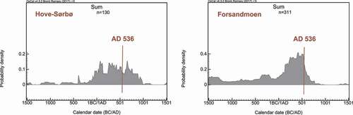
At Forsandmoen, the compilation shows a moderate and relatively steady frequency of radiocarbon dates from around 1500 BC until it increases in the first century AD (). The number of radiocarbon dates thereafter remains high for 400 years before a substantial decline at around AD 550 and during the following century. There are a few dates recorded from the Early Viking Period before they are reduced to almost zero.
CEREAL DISTRIBUTION
At Hove-Sørbø, the macrofossil crop composition is relatively varied over time, although barley is most numerous in all periods (, ). Barley dominates in the samples from AD 400–550, complemented by 12% oats and a few grains of rye and wheat. In AD 550–800, rye is introduced as a new crop, while barley is still most common. There are also a few grains of oat. From AD 800–1050, rye disappears again and is replaced by oats as the second most common crop. The preservation of the seeds found in the samples varies, but in total, 60% of the cereal grain could be identified. For most barley grains, it was not possible to distinguish between hulled or naked variety, but when it was possible to make a distinction, the vast majority was hulled. During the analysis, no differentiation was made between Hordeum distichon and Hordeum vulgare. However, Iron Age barley from southwestern Norway is generally considered to be the six-rowed variety, Hordeum vulgare, and to our knowledge, no two-rowed barley has been recorded. A relatively large number of rye and barley seeds were found in samples from one single house (house 36), dated to the 7th century. These samples have a large impact on the cereal distribution during that time interval.
Fig. 5. Changes in crop composition over time. The diagrams show percentage of identified cereal grains from each period.
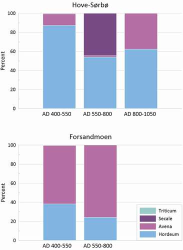
Table 1. Number of seeds per 10 litres at Hove-sørbø.
At Forsandmoen, oats dominate the crop assemblages, followed by barley, both in the Migration Period and the Merovingian Period (, ). From AD 400–550, oats comprise 61% of the material, complemented by barley and a few grains of rye and bread wheat. In AD 550–800, oat increases to 76% and is only complemented by barley. As in the samples from Hove-Sørbø, the barley grains not identified to subspecies are likely to be hulled. In total, 63% of the cereal grains could be identified.
Table 2. Number of seeds per 10 litres at Forsandmoen.
ECOLOGICAL GROUPS
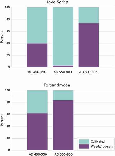
At Hove-Sørbø, the non-cultivated taxa in AD 400–550 consist of 55% weeds/ruderals and 22% edible berries and nuts. Grassland taxa and wetland/seashore taxa each comprise around 11% of the material (, ). In AD 550–800 weeds/ruderals and edible berries and nuts stay at a similar level while grassland taxa increase to 21% and wetland/seashore taxa decrease to 5%. From AD 800–1050, weeds/ruderals are still the largest group while wetland/seashore taxa increase significantly to 21% and grassland taxa and edible berries and nuts decrease. The wetland/seashore taxa category is dominated by Carex in all three periods, while the most common weed in all periods is Stellaria media, followed by Spergula arvensis, Persicaria and Chenopodium album. The cultivated versus weeds/ruderals ratio at Hove-Sørbø is 60:40 in AD 400–550 (). The proportion of cultivated taxa increases significantly in AD 550–800, but this is due to the large cereal finds from house 36. In AD 800–1050, the ratio is 27:73. At Forsandmoen, weeds/ruderals dominate the seed assemblages from both periods, at around 73% (, ). Grassland taxa is the second most common category in both periods, while the edible berries and nuts increase slightly from AD 550–800. The same weeds that were mentioned for Hove-Sørbø are also common at Forsandmoen, but in addition, there is a significant amount of Galium aparine and Persicaria hydropiper. Grassland/grazing is also a substantial group, where Rumex acetosella is the most common species, followed by Poaceae and Plantago lanceolata. Among the edible berries and nuts, hazelnut, Corylus avellana, is by far the most common on both sites. At Forsandmoen, the cultivated versus weeds/ruderals ratio is 38:62 in AD 400–550 (). In AD 550–800 the weeds/ruderals increase, and the ratio is 17:83.
Fig. 6. Ecological grouping of non-cultivated taxa presented over time.
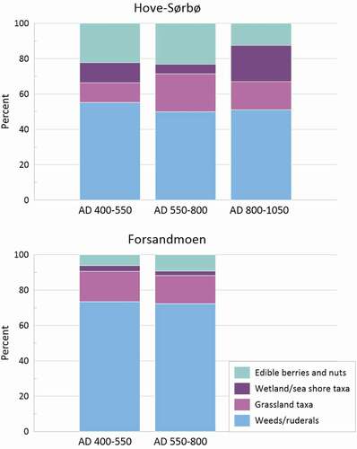
Fig. 7. The proportion of cultivated taxa compared to weeds/ruderals over time. The dominance of cultivated taxa at Hove-Sørbø in AD 550–800 is explained by two large cereal finds from this period.
FAUNAL COMPOSITION
In the Forsandmoen report by Hufthammer (Citation2004), 61 of 306 bones were identified. They can date from anytime during the lifespan of the village, i.e. from the early Bronze Age to the end of the Migration Period (AD 550). Of the 61 identified bones, 28 were definitively identified as sheep/goat (around 10% of the total number), and a further 7 as small domesticates, which are likely to be sheep/goat. Due to their size, 10 bones were identified as possible pig, whereas small numbers of bird, fish, seal, beaver, deer, and hare were found. Remarkably, no bones were identified as cattle, or other large size domesticates.
In his new publication on the settlement at Forsandmoen, Trond Løken (Citation2020) summarizes, in addition to Hufthammer (Citation2004), unpublished faunal analyses done by Hufthammer, from altogether 147 contexts containing 984 fragments of burnt bone, collected from 62 features. Five bones were identified as cattle phalanges, all from a single feature dated to the Migration Period. The other identified bones were: 24 from sheep/goat, four from pig, three from bird, two probably from deer, and one each from fish, hare and seal. According to Løken (Citation2020), the bones from sheep/goat were found in contexts from all phases of the settlement.
From Hove-Sørbø, fewer bones were retrieved, and their preservation was even poorer than those from Forsandmoen. However, the few fragments that were identified show a distinctly different pattern than at Forsandmoen. Four features contained cattle bones, another four contained pig bones and again another four contained sheep bones. Two features contained fish bones. The exact number of bones within each feature is not given (S. D. Denham 2019, pers comm, 8 October). Wild animals are not found (except one bone that could either be a small cow or a large deer).
DISCUSSION
AGRICULTURAL DEVELOPMENT
From around the turn of the first millennium AD, a population increase and an agrarian expansion can be seen in southwestern Norway, as well as in the rest of Scandinavia (Welinder et al. Citation1998, p. 267, Myhre Citation2002, p. 119, Fredh et al. Citation2022, Hjelle et al. Citation2018, Odgaard and Nielsen Citation2009). The increasing supply of iron aided the development of new tools, such as the iron sickle and the short scythe. The latter, together with the hay rake, rationalized the collection of animal fodder. This increase in fodder would have increased the size of the animal stocks, and in turn the amount of manure, which could be used for expanding and making the arable land more permanent (Boserup Citation1965, Myrdal Citation1997, pp. 304–306). Larger and more productive fields, resulting in higher crop yield, probably led to population growth. This expansion pattern fits well with the records from Hove-Sørbø and Forsandmoen, as the increasing amount of radiocarbon dates () and number of house remains (Dahl et al. Citation2019, Bjørdal Citation2014, Bjørdal et al. Citationforthcoming, Løken Citation2020) suggest that the settlement of Hove-Sørbø grew considerably from around the first century BC and the settlement of Forsandmoen from around the first century AD
The general development of crop composition during the Iron Age appears to have been relatively similar throughout Scandinavia. The broad-spectrum agricultural strategy with many different crops disappeared during the Early Iron Age and naked barley, which had been the dominant crop since late Neolithic was gradually replaced by hulled barley. In Denmark, some wheat and millet were cultivated, and oats and rye became more common towards the end of the Iron Age (Robinson et al. Citation2009). Gold of pleasure and flax were grown for oil, and flax was also used as a fibre plant. In Sweden, flax was introduced during the Pre-Roman Iron Age and rye during the Roman Iron Age (AD 0–400), and both rye and oats became increasingly important crops during the last centuries of the Iron Age (Grabowski Citation2011).
In Norway, crop diversity was always more limited than in Denmark and Sweden. Hulled barley replaced naked barley as the dominant crop and oats became more important during the Iron Age, but the introduction of rye happened considerably later, and the cultivation of other crops was very limited (Sandvik Citation2008, Westling and Jensen Citation2020). Trading networks with southern Scandinavia and Europe were well established, as can be seen in the archaeological material (Solberg Citation2000, pp. 73–87), and a larger variety of crops must have been known and available to the farmers in Norway during Iron Age as well as in other periods. However, the harsher climate likely limited people’s options. In southwestern Norway, the crop composition changed during the first 400 years AD from a dominance of wheat and naked barley to oats and hulled barley as the most common crops (Prøsch-Danielsen and Soltvedt Citation2011).
This general picture corresponds well with the crop composition at Hove-Sørbø and Forsandmoen from AD 400–550, which is dominated by hulled barley and oats respectively. Nitrophilous weeds such as Stellaria media, Chenopodium album and Persicaria sp. were common at both Hove-Sørbø and Forsandmoen during this time (electronic supplementary), suggesting well-manured fields, but there are a few local variations in the weed flora. At Forsandmoen, Persicaria hydropiper is common in the Migration Period. This species thrives on acidic, poorly drained soils (Korsmo et al. Citation1981) and may indicate deteriorating soil quality.
The settlement activity at both Hove-Sørbø and Forsandmoen peaked during the Migration Period, according to the distribution of radiocarbon dates. This peak coincides with the culmination of the Early Iron Age agrarian expansion in the mid-6th century AD (Welinder et al. Citation1998, p. 267, Myhre Citation2002, p. 119). The decline that followed coincides with the 6th century crisis. Climate change and plague may have led to a considerable decrease in population, and the archaeological finds clearly show a decrease in human activity in Rogaland at this time (Myhre Citation1991, pp. 15–17, Citation2002, pp. 170–173). A recent study shows that the number of sites in Rogaland with archaeological finds are reduced by 70% from the Migration Period to the Merovingian Period, while the number of finds is reduced by 87% (Vetrhus Citation2017). Some abandoned Migration Period farms are still visible in the landscape as ruins. In the 1930s, a study of visible remains of prehistoric farms in Rogaland suggested that 24 of the 30 abandoned farms known in the region, could be dated to the Migration Period (Petersen Citation1933, p. 77).
One of the clearest examples of farm abandonment in southwestern Norway is the settlement at Forsandmoen, where human activity decreased rapidly in the 6th century until only a few houses remained around a century later. Around AD 700 the whole settlement appears to be abandoned (, Dahl Citation2008, Citation2021 Løken Citation2020). In the last century of settlement activity, oats increased to constitute 76% of the cereal crops, only complemented by barley. The poor soils and the iron pan probably made oats the most favourable crop to grow. The high number of weed seeds in the material, which increases in the last period of activity (, ), also indicates agricultural challenges. There may have been fewer people to manage the fields, or perhaps there was a higher tolerance for weeds in the food grain due to a lack of food.
Pollen data from central and northern Europe shows widespread regrowth of woodland during the 6th century crisis (Andersen and Berglund Citation1994). This is not true for Rogaland, however, as the upper part of most sediment sequences analysed for pollen from this region, representing the last c. 2000 years, seems to indicate a very stable landscape that was consistently open (Prøsch-Danielsen and Sandgren Citation2003, Midtbø Citation2011). Although the vegetation development inferred from this time interval is based on relatively few radiocarbon dates, the stable vegetation cover suggests that the landscape remained open throughout the 6th century crisis and later.
Only a few pollen diagrams from southwestern Norway suggest a temporary woodland regrowth during the last 2000 years, but this change is generally assigned to the Black Death, after c. AD 1350 (Simonsen Citation1971, Høeg Citation1999). However, since the temporal resolution in the available pollen data is generally low, a short period of land abandonment, or a change in land use, may not be visible. Pollen analysis from Forsandmoen suggests that the local landscape was kept open during and after the 6th century crisis, but that cultivated fields were replaced by grazed heathland (Prøsch-Danielsen and Simonsen Citation1988, Høeg Citation1999). This land-use change could indicate an increased focus on animal husbandry.
The crisis is less visible in the radiocarbon dates from Hove-Sørbø. The settlement activity decreased slightly in the 6th century but was back at the same level in the 8th century, although with some structural changes. In connection with the crisis, the site seemingly lost its status as a magnate farm and the settlement split into two units (Bjørdal et al. Citationforthcoming). A shift in the cereal composition is another sign of change at Hove-Sørbø. Oats decreased significantly and rye was introduced as a new crop (, ).
The rye from Hove-Sørbø, radiocarbon dated to the 7th century AD, is the earliest find of a rye crop in Norway, and so far, the only one from the Iron Age (Westling and Jensen Citation2020). Small amounts of rye pollen and rye grains have been found at many Iron Age sites in Norway (e.g. Helliksen Citation1997, Soltvedt Citation1997, Sandvik Citation1999, Thommessen Citation2013, Sæther Citation2018), but the quantities are not large enough to conclude that rye has been cultivated. A few grains or pollen of rye have sometimes been interpreted as cultivation in archaeological excavation reports, although the botanical data, or indeed the archaeobotanical interpretation, does not support this. Concentrations rather than scattered finds indicate cultivation, as rye may have grown as a weed among other crops. A sample with a larger number of grains, dominated by rye, is therefore necessary to determine if cultivation is probable (Westling and Jensen Citation2020). Several large excavations of Iron Age sites in Norway have also failed to produce any, or more than a few, rye grains. Among them, are the E18 project Langåker-Bommestad (Vestfold county), where 456 macrofossil samples and 43 pollen samples were analysed without any traces of rye (Soltvedt and Enevold Citation2008). There is also the excavation at the Ørland Main Air Base (Trøndelag county), where 322 macrofossil samples and 9 pollen samples were analysed and only one grain of rye was noted (Buckland et al. Citation2017, Ystgaard Citation2019). The Dobbeltspor Dilling project (Innlandet county) is another example, where 240 macrofossil samples were analysed and only one grain of rye was noted (Ahlqvist et al. Citation2018). This makes it unlikely that rye was commonly grown as a crop at this time.
During the Viking Period, the climate grew warmer. The start and duration of this climate anomaly, called the Medieval Warm Period, is debated but most researchers agree that, for a few centuries in the Viking Period and Early Middle Ages, temperatures were high in comparison to the Merovingian Period (Mann et al. Citation2009, Patterson et al. Citation2010, Young et al. Citation2015). In much of Scandinavia, this warm period was characterized by agricultural expansion and population growth (Myrdal Citation1988, p. 207, Øye Citation2002, p. 217, Berglund Citation2003). The development was connected to, among other things, new tools, such as the iron-shod wooden spade and a longer iron ard share. The spade made it easier to break new land and the ard share made the fields more productive by improving the soil preparation (Myrdal Citation1988, p. 207).
At many settlements, the farms were relocated during the Viking Period. This is partly true for Hove-Sørbø, where the main settlement was abandoned. Instead, new houses were built to the northeast of the main settlement. However, the settlement to the southwest lived on. There were also changes in the agricultural strategies. The crop composition at Hove-Sørbø changed once again and oat cultivation increased while rye disappeared. Hulled barley remained the dominant crop. A decrease in crops in relation to grassland and wetland taxa can be seen in the macrofossil material, which could indicate an increased focus on animal husbandry (, ).
CLIMATE CHANGE, PANDEMIC AND THE POSSIBLE IMPACT ON AGRICULTURE
The archaeological settlement data and archaeobotanical evidence from southwestern Norway demonstrate that society experienced a crisis during the 6th and 7th centuries. The societal development during this time, both on a European and on a local scale, is complex. Many possible factors, including political and social changes or conflicts, could have contributed to this development, but two factors dominate the discussion of what caused the crisis: climate change and pandemic. This discussion will focus on the possible effect these factors could have had on the development of agriculture in southwestern Norway.
Following the large volcanic eruptions in AD 536 and 540, the average summer temperatures in Europe dropped by more than 2°C. A solar minimum, coinciding with the volcanic eruptions, amplified the effect and the cold period may have lasted until AD 660 (Stothers and Rampino Citation1983, Briffa et al. Citation1992, Larsen et al. Citation2008, Sigl et al. Citation2015, Büntgen et al. Citation2016, Toohey et al. Citation2016). Crop-failure, famine and cold weather are reported from many parts of the world (Procopius of Caesarea Citation1924, Cassidorius Citation1992, Arjava Citation2005, Price and Gräslund Citation2015), but the climate changes were likely even stronger in Scandinavia due to its northerly latitude (Toohey et al. Citation2016). Scandinavia is a marginal area for agriculture (Toohey et al. Citation2016, p. 407), and even a relatively modest climate deterioration may have had devastating effects. Demands on growing conditions, such as temperature, soil and precipitation, vary between cereal species, but three climatic variables are crucial for successful cereal cultivation: soil moistness during sowing, sufficiently high temperature during the vegetation period and low precipitation during harvest (Pedersen and Widgren Citation1998, p. 252, Frøseth Citation2004).
The temperature can be expressed in Growing Degree Days (GDD) (Frøseth Citation2004, p. 173, Stamnes Citation2016, p. 29). This is the most important factor for determining what areas are suitable for different cereal crops. A study from Nord-Trøndelag, a region of Norway located around 500 km north of Rogaland, analysed the effects that a temperature drop would have had on growing conditions in connection with the 6th century crisis (Stamnes Citation2016). The study concludes that a temperature drop of 1°C would have reduced the area where cereals could be grown considerably, while a 3.5°C drop would have excluded successful cereal cultivation in the entire area. No such study has been conducted for Rogaland, and these results cannot be directly applied, but they indicate that a negative impact on the growing conditions is likely.
In addition to temperature, volcanic events can impact weather patterns and result in more rainfall. A study from Sweden shows rising lake levels as well as increased peat-accumulation rate around the time of the crisis (Berglund Citation2003, p. 10). This could be the result of lower temperatures and less evaporation or more precipitation during this period. Wetter climate affects the temperature demand for cereals in a negative way, increasing the necessary GDD to compensate for the rainfall (Frøseth Citation2004, Stamnes Citation2016, p. 29). Apart from the immediate effects of climate change on the cultivation of cereals and other crops, which entails reduced crop yield, the livestock would also have been affected. Cattle are more susceptible to diseases in wet conditions, and milk production can be reduced by cold and wind (Pedersen and Widgren Citation1998, p. 255). A way to counter this would be by stabling the animals, but that increases the demand for hay and, in turn, for labour.
The complexity of the 6th century crisis is demonstrated by a suggested causal relationship between climate variation and pandemics (Rosen Citation2006, pp. 200–203, Stenseth et al. Citation2006), as well as between famine and plague outbreaks (Stothers Citation1999).
Analyses of ancient DNA have confirmed that the Justinian Plague pandemic was bubonic plague (Wagner et al. Citation2014) and the bacteria, Yersinia pestis, has been found in 6th century skeletal remains in southern Germany, establishing that the disease reached north of the Alps (Harbeck et al. Citation2013). An outbreak in Scandinavia has been discussed as one possible factor behind the crisis (Gräslund Citation1973, Myhre Citation2002, pp. 172–173), but others question this (Pedersen and Widgren Citation1998, p. 311).
Based on archaeological data, such as radiocarbon dates (Solheim and Iversen Citation2019), settlement patterns and find distributions (Vetrhus Citation2017), a large population decrease in Norway in the 6th century seems likely. Regardless of whether this was caused by crop failure and starvation or by plague, the effects would have been similar. The immediate effect for agriculture would have been a lack of people to work the fields and care for the animals. As a consequence of this, time-consuming activities, such as manuring the fields, weeding and fodder gathering, may have suffered, giving way to agricultural strategies that are less labour-intensive.
A structural vulnerability in the agricultural system could also have contributed to the far-reaching consequences of the 6th century crisis in Scandinavia. Agrarian historian Janken Myrdal suggests that a crisis may hit extra hard when expansion has stopped and the agricultural system has reached its maximum capacity. Myrdal uses agrarian techno-complexes, as a generic term for agricultural technology. This includes tools like ards and spades, knowledge about manuring, crop rotation etc. He argues that the prevailing agrarian techno-complex, in interaction with the landscape and natural resources, limits the capacity of the system. When maximum capacity has been reached, i.e. the number of people the landscape can support with the available technology, the society becomes vulnerable as it is running low on resources (Myrdal Citation1982, Citation1988, Citation1997, Citation1999, Citation2005). Such a development is plausible for Scandinavia, as an incipient decline in agricultural activity can be seen already in the 5th century in some areas (Lagerås Citation2013, Gjerpe Citation2017, pp. 194–197, Solheim and Iversen Citation2019).
STRATEGIES AND AGRICULTURAL ADAPTATIONS AT FORSANDMOEN AND HOVE-SØRBØ
Crop Choices and Diversification
Ever since agriculture was first introduced in southwestern Norway in the Late Neolithic (Soltvedt Citation2000), cereals have constituted a large part of the diet (Myhre Citation2002, Halvorsen and Hjelle Citation2017). The dependence on cereal crops meant, as for any agriculturally based economy, a vulnerability to changing climate and weather conditions. The decrease in crop diversity during the Iron Age could also have worked to the disadvantage of the Rogaland farmers, as diversification is one of the most efficient ways of increasing agricultural resilience. At Hove-Sørbø and Forsandmoen, oats and hulled barley, respectively, constitute the main part of the grain finds. Growing plants with different requirements, on different fields or as mixed crops, significantly lowers the risk of complete harvest failure (Bakels Citation2012). However, it is worth considering that a climate change in the 6th century, as dramatic as suggested by recent research, may have led to crop failure in the years following the dust veil event, regardless of crop composition.
A different crop composition could have facilitated a recovery when climate improved again. In the 7th century, Hove-Sørbø temporarily introduced rye as a new crop (Westling and Jensen Citation2020). This could have been part of a strategy to increase diversification at the site, and rye would have been a good choice because of its hardiness (Behre Citation1992, Engelmark Citation1992). But for some reason, rye was not integrated fully into the agricultural system at Hove-Sørbø and did not become common in southwestern Norway until around 500 years later. As rye is usually grown as a winter crop, it may have been difficult to incorporate it into the prevailing cultivation system. Instead, this crop was included in the new agricultural techno-complex that developed during the Viking Period and Early Medieval Period (Myrdal Citation1988).
At Forsandmoen, the choice of oats as a main crop was likely due to poor soil conditions. The iron pan that covers most of the area today may have started developing as early as the Migration Period, as indicated by the weed flora, and supported by the archaeological excavations (Løken Citation2020). The area was completely deforested, and the heathland gradually established from the Late Roman Iron Age (AD 200–400) (Prøsch-Danielsen Citation1996). The heathland suggests that the soil was acidic and nutrient poor, which would have made oats a better crop choice than hulled barley. The large percentage of weed seeds in the macrofossil material throughout the settlement period () further demonstrates the agricultural challenges. Due to the poor soils, agriculture at Forsandmoen was probably complemented by other means of subsistence, particularly trade with outland resources.
Animal Husbandry, Hunting and Fishing
The faunal remains from Forsandmoen and Hove-Sørbø are fragmented, and the small number of identified bones cannot serve as a blueprint of an economic strategy for any one time period. However, they give indications towards the presence and absence of species. The composition of identified species indicates strategies related to husbandry, hunting and companion animals.
Trond Løken (Citation2020) suggests that Forsandmoen housed 300–400 cattle and 200 people during the Migration Period. However, he also concludes that the land available for grazing would not have been enough for this amount of cattle. A high number of cattle is also inconsistent with the osteological material, which contains very few cattle bones (Løken Citation2020). The presence of bones from small animals, such as fish and birds, indicates that the low number of cattle bones is not a result of a representative bias but of a low number of cattle on site, since bigger and denser bones generally preserve much better than bones from smaller animals. Therefore, there are pointers towards the absence of cattle at Forsandmoen, at least prior to the Migration Period. We suggest that the faunal remains from domestic animals represent the actual animals present at the settlement and that sheep and/or goats were the main animals kept on site, as well as some pigs (Oma Citation2018). The relatively large number of sheep/goats suggests that wool from these animals was important for the economy, which implies that the settlement potentially depended on food import to sustain the population in the village.
Forsandmoen is located where the mountains meet the sea, making it perfectly situated for utilizing marine resources, as well as trekking up into the mountains for trapping and hunting game, and for herding flocks of sheep to mountain pastures in the summer. The presence of fish and seal, birds and wild animals like beaver, deer and hare in the osteological material suggests that resources other than strictly domestic were used. During recent years, glacial archaeologists in Norway have discovered an increase in reindeer hunting during the 6th and 7th century cold period (Pilø et al. Citation2018). Intensified hunting may be a sign that agricultural yields were low and needed supplementing. Depending on the availability of wild game in the area, and to what extent this resource was already used, increased hunting as a strategy to supplement the food supply may have been employed at Forsandmoen.
At Hove-Sørbø, with its fertile soils, the faunal remains demonstrate a different and more diverse husbandry practice, as well as a different approach to the wider landscape. Here, cattle, sheep and pigs were part of the agricultural subsistence strategy, as was fishing. Most of these animals were common in the traditional agricultural society, which suggests that food production was mainly carried out locally. Wild animals are absent from the osteological material and are unlikely to have been an important part of the diet (Denham in prep.). Unfortunately, the lack of radiocarbon dated bones from both Forsandmoen and Hove-Sørbø makes it difficult to draw conclusions about how the dependence on domestic as well as wild species changed over time.
Extensification, Outfield Resources and Trade
The proportions of animal husbandry versus crop cultivation in the subsistence is a variable that can be adjusted to cope with disturbances to the established system, in particular a reduced population. This strategy was discussed in a Swedish research project studying the Black Death, which can be used as an analogue to the 6th century crisis (Lagerås Citation2016). It was concluded that animal husbandry in relation to crop cultivation became more important after the population drop, which appears to have been a strategic adaptation to shortage of labour and excess of land. If the population dropped, because of plague or crop failure, an adjustment of the relative amount of animal husbandry and cereal cultivation could be a useful strategy, which has been suggested also for 6th century Norway (Iversen Citation2016, pp. 43–44). A climate deterioration would, however, have affected all vegetation and a lack of fodder might also have limited the number of livestock that could be kept.
Because of the poor soil at Forsandmoen, reduced crop cultivation and increased animal husbandry may not have been a sustainable option, since the land itself was likely already insufficient for feeding the population. The settlement probably also depended on trade in items acquired from the nearby mountains, such as timber, furs from wild animals, wool from sheep that were grazing in the mountains and bog iron. A trade route over the mountains between Setesdal, a valley located in Agder County, west of Rogaland, and Lysebotn (the northeastern part of Rogaland) is known from the Medieval Period. This passage is thought to have been used at least from the Migration Period and the mountain area has been used for hunting from as far back as 4000 BC (Tjeltveit Citation1999). The Forsandmoen settlement could also have been involved in the considerable iron production in both Rogaland and Agder from the roman iron age (0–400 AD) (Kallhovd and Larsen Citation2006, Mjærum and Larsen Citation2014).
The collapse in trading networks between the continent and the north around this time is well established (Hedeager Citation1987, Citation2011, Young Citation2000). It follows that the demand for trade products would have been heavily reduced, and the supply of available food to trade for goods such as furs and iron would have been low or even non-existent. The Norwegian coastal areas have been the contact points for trade with the continent, and the area around Forsandmoen appears to have been of great importance (Dahl Citation2021). A crisis on the continent may therefore have had a negative effect on the settlement at Forsandmoen, leading to starvation and subsequently abandonment of the settlement. It is clear that Hove-Sørbø was also connected to these far-reaching trading networks (Reiersen Citation2011), but as their economy was most likely build on local production, the breakdown of these network would have had a smaller impact.
Pollen analyses suggest that Forsandmoen was used solely for grazing after the abandonment of the settlement, around AD 600 (Prøsch-Danielsen Citation1996). Only with the introduction of mechanized agriculture, in the 20th century, was it possible to break up the iron pan and cultivate the area again (Engen Citation1985, p. 445, Løken Citation2020). Pollen samples from Hove-Sørbø, dating from the 4th to the 9th century, contain large amounts of pollen from species indicative of grazing, such as Poaceae, Plantago lanceolata, Rumex acetosa and Ranunculus acris, showing the importance of domestic animals in the economy (Bjørdal et al. Citationforthcoming). No clear changes in grazing activity can be seen in the pollen material during or after the crisis, but Hove-Sørbø’s favourable location on rich agricultural soil would presumably have provided better opportunities than Forsandmoen for adjusting the cultivation versus animal husbandry ratio.
A transition from intensive to extensive crop cultivation, with less manure, is another possible strategy. This strategy demands less labour but the output per m2 is lower (Boserup Citation1965, pp. 35–55). Also, the length of the stabling season could be shortened, to reduce the need for hay fodder and hence the workload. A study discussing crop yield variability in Finland after AD 760 argues that the main response to deteriorating climate and decreasing crop yield was to expand the cultivated area (Huhtamaa and Helama Citation2017). After a population reduction, there would have been a surplus of land but a shortage of labour, and less labour-intensive strategies could have been employed. Extensive crop cultivation could have been an option for Hove-Sørbø when recovering from the crisis.
CONCLUSIONS
Resilience can be explored on many levels and on different scales. In this study, the focus has been on the settlement level. Both Hove-Sørbø and Forsandmoen were part of the larger agricultural society of southwestern Norway. While a breakdown of craft traditions and largescale farm abandonment demonstrate that, to some degree, the society at large succumbed to the crisis, the small-scale societies, which Hove-Sørbø and Forsandmoen represent, could have been equipped to sustain the settlements.
However, after the 6th century crisis, only one of the two sites investigated in this study was still inhabited. Hove-Sørbø was sufficiently resilient to withstand the crisis while Forsandmoen was not. Abundant and fertile land, allowing for less labour-intensive agriculture, in combination with the benefits of being a rich magnate farm, may have ensured the survival of the settlement at Hove-Sørbø. The introduction of rye also indicates an ability and willingness to adapt, which may have helped the recovery. The temporary decline in activity suggests a population drop at Hove-Sørbø, but although the settlement structure and the crop composition at the site was altered, the settlement prevailed.
At Forsandmoen, the local conditions, especially the poor soil, limited the strategic choices available and necessitated a trade-based economy. When the trading networks collapsed, the lack of fertile agricultural land meant that the settlement did not have sufficient means to provide food for the inhabitants. Possibly, part of the population at Forsandmoen died of starvation and the settlement was deserted. The different outcomes between Hove-Sørbø and Forsandmoen indicate that a local, independent subsistence practice was more favourable than being dependent on import of food in a time of crisis. This study demonstrates that societal resilience depends on a complex interplay between, on the one hand, the ability to expand the scope of subsistence strategies, and on the other, the restraints inherent in the landscape and ecosystem in which the settlement is embedded.
Acknowledgements
This publication is a contribution to the University of Stavanger research programme BEAM – Biological Environmental and Archaeological interdisciplinary research on life-course, Material and materiality in human depositions. We thank Even Bjørdal and Trond Løken for valuable information regarding the archaeological excavations at Hove-Sørbø and Forsandmoen and Dr. Sean D. Denham for personal communications regarding the osteological analysis of the material from Hove-Sørbø.
DISCLOSURE STATEMENT
No potential conflict of interest was reported by the authors.
REFERENCES
- Ahlqvist, et al., 2018. Miljöarkeologiska analyser av prover från huslämningar i Dobbeltspor Dilling, ID 216874, Rygge kommune, Østfold, Norge. Environmental archaeology lab, report no. 2018-011. Department of historical, philosophical and religious studies, Umeå University.
- Anderberg, A.L., 1994. Atlas of seeds and small fruits of Northwest-European plants species: part 4. Resedaceae-Umbelliferaea. Stockholm: Swedish Museum of Natural History.
- Andersen, T., and Berglund, B., 1994. Maps for terrestrial non-tree pollen (NAP) percentages in north and central Europe 1800–1450 B.C. Paläoklimaforschung, 12, 119–134.
- Arjava, A., 2005. The mystery cloud of 536 CE in the Mediterranean sources. Dumbarton Oaks Papers, 59, 73–94. doi:https://doi.org/10.2307/4128751
- Axboe, M., 1999. The year 536 and the Scandinavian gold hoards. Medieval Archaeology, 43, 186–188.
- Bakels, C., 2012. Avoiding crop failure in the Iron age: maslins and emergency crops on the loess soils of western continental Europe, with a special note on oat (Avena sativa) and foxtail millet (Setaria italica). Analecta Praehistorica Leidensia, 43–44, 177–182.
- Bakkevig, S., 1991. Charred seeds from Forsandmoen, a prehistoric village in SW-Norway. Methods of retrieval and results from the Bronze age. In: S. Vytlacok, ed., Palaeoethnobotany and archaeology. International work-group for paleoethnobotany 8th symposium, Nitra-Nove Vozokany 1989 Vol. VII. Acta Interdisciplinaria Archaeologica. Nitra: Archaeological Institute of the SlovakAacademy of Sciences, 29–36.
- Bakkevig, S., 1992. Prehistoric cereal raising at forsandmoen, south-west Norway: changes between the Bronze age and the Iron Age. Laborativ Arkeologi, 6, 49–56.
- Bakkevig, S., 1995. Neue makrofossile beiträge zur kenntnis des vorhistorischen getreidanbas in südwestnorwegen. In: H. Kroll and R. Pasternak, eds., Archaeobotanica – 9th symposium IWGP. Kiel 1992. Kiel: Oetker-Voges, 5–15.
- Bakkevig, S., 1998. Problemer i bronsealderens korndyrking på Forsanmoen, Rogaland, SV-Nore. In: T. Løken, ed., AmS-varia Vol. 33. Bronsealderen i Norden Regioner og interaksjon. Regioner og interaksjon. Stavanger: Museum of Archaeology, Stavanger. National research centre for paleostudies and conservation, 55–62.
- Behre, K.-E., 1992. The history of rye cultivation in Europe. Vegetation History and Archaeobotany, 1 (3), 141–156. doi:https://doi.org/10.1007/BF00191554
- Berggren, G., 1969. Atlas of seeds and small fruits of Northwest-European plants species: part 2. cyperaceae. Stockholm: Swedish Natural Science Research Council.
- Berggren, G., 1981. Atlas of seeds and small fruits of Northwest-European plants species: part 3. Salicaceae-cruciferae. Stockholm: Swedish Natural Science Research Council.
- Berglund, B.E., 2003. Human impact and climate changes—synchronous events and a causal link? Quaternary International, 105 (1), 7–12. doi:https://doi.org/10.1016/S1040-6182(02)00144-1
- Bjørdal, E., 2014. Garder og graver frå steinalder til mellomalder på Hove og Sørbø. Fra Haug Ok Heidni, 3 2014, 10–19.
- Bjørdal, E., 2016. Late iron age settlement evidence from Rogaland. In: F. Iversen and H. Petersson, eds., The agrarian life of the north 2000 BC – AD 1000 – studies in rural settlement and farming in Norway. Kristiansand: Portal academic, 27–39.
- Bjørdal, E., Westling, S., and Jensen, C.E., 2022. Preliminary title: arkeologiske utgravinger på Hove-Sørbø, gnr. 44 og 45, sandnes kommune, Rogaland. AM oppdragsrapport. xxxx/xx Universitetet i Stavanger:Arkeologisk Museum.
- Blaikie, P., et al., 1994. At risk – natural hazards, people’s vulnerability, and disasters. London: Routledge.
- Boserup, E., 1965. The conditions of agricultural growth: the economics of agrarian change under population pressure. Chicago: Aldine Publishing Company.
- Briffa, K.R., et al. 1992. Fennoscandian summers from AD 500: temperature changes on short and long timescales. Climate Dynamics, 7 (3), 111–119. doi:https://doi.org/10.1007/BF00211153
- Buckland, P., et al., 2017. Environmental archaeological analysis from the archaeological excavations at Ørland kampflybase, Vik 70/1, Ørland, Sør-Trøndelag, Norway. Environmental archaeology lab, report no. 2017-012. Department of historical, philosophical and religious studies, Umeå University.
- Büntgen, U., et al. 2016. Cooling and societal change during the late antique little ice age from 536 to around 660 AD. Nature Geoscience, 9 (3), 231–236. doi:https://doi.org/10.1038/ngeo2652
- Cappers, R.T.J., Bekker, R.M., and Jans, J.E.A., 2006. Digitale zadenatlas van Nederland – digital seed atlas of the Netherlands. Groningen: Barkhuis publishing & Groningen University Library.
- Cassidorius, M.A., 1992. The variae of magnus Aurelius cassiodorus senator. Edited and translated by S.J.B. Barnish, Liverpool: Liverpool University Press.
- Dahl, B.I., 2008. Arkeologisk utgraving på Forsandmoen 2007. Forsand gnr. 41 bnr. 4, Forsand kommune. In: AM oppdragsrapport. Museum of Archaelogy in Stavanger. 2008/15.
- Dahl, B.I., Soltvedt, E.-C., and Lechterbeck, J., 2019. Utgraving av gravhauger og hus på Forsandmoen – forsand gnr. 41 bnr. 5, Forsand k. Rogaland. In: AM oppdragsrapport. Museum of Archaeology, University of Stavanger. 2019/03.
- Dahl, B.I., Samuelson, M.K., and Hamre, E., 2021. Arkeologiske undersøkelser av hus i røysfelt øst på Forsandmoen. Forsand gnr. 241 bnr. 6, sandnes kommune, Rogaland (del av id. 64670). Museum of Archaeology, University of Stavanger. AM Oppdragsrapport 2021/31.
- Dahl, B.I., 2021. Nye perspektiver på Forsands forhistorie. Fra Haug Ok Heidni, 2021 (2), 3–12.
- Engelmark, R., 1992. A review of the farming economy in South Scania based on botanical evidence. L. Larsson, et al.Eds., The archaeology of the culture landscape – field work and research in a south Swedish rural region. Acta archaeologica lundensia, 4 (19 Stockholm:Almquist & Wiksell International, 369–374.
- Engen, S., 1985. Forsandboka. gards- og ættesoge, band II. Forsand: Forsand kommune.
- Findlay, R., and Lundahl, M., 2017. Demographic shocks and the factor proportions model: from the plague of justinian to the black death. In: R. Findlay and M. Lundahl, eds., The economics of the frontier: conquest and settlement. London: Palgrave Macmillan UK, 125–172.
- Fredh, E.D., Prøsch-Danielsen, L., and Jensen, C.E., 2022. A synthesis of pollen composition in prehistoric cultivation layers in Southwestern Norway. Environmental Archaeology, 127–145.
- Fredriksen, P.D., Kristoffersen, E.S., and Zimmermann, U., 2014. Innovation and collapse: bucket-shaped pottery and metalwork in the terminal migration period. Norwegian Archaeological Review, 47 (2), 119–140. doi:https://doi.org/10.1080/00293652.2014.945476
- Fremstad, E., 1997. Vegetasjonetyper i norge. NINA Temahefte, 12, 1–279.
- Frøseth, R.B., 2004. Korn. In: G.L. Serikstad, ed., Norsøk økologisk handbook. matvekster. Oslo: GAN, 167–187.
- Gjerpe, L.E. 2017. Effektive hus. Bosetning, jord og rettigheter på Østlandet i jernalder. Thesis (PhD). University of Oslo.
- Göthberg, H., 2007. Mer än bara hus och gårdar. In: H. Göthberg, ed., Hus och bebyggelse i Uppland. Delar av förhistoriska sammanhang. Uppsala: Upplandsmuseet Riksantikvarieämbetet, 403–447.
- Grabowski, R., 2011. Changes in cereal cultivation during the iron age in southern Sweden: a compilation and interpretation of the archaeobotanical material. Vegetation History and Archaeobotany, 20 (5), 479–494. doi:https://doi.org/10.1007/s00334-011-0283-5
- Gräslund, B., 1973. Äring, näring, pest och salt. Tor, XV, 274–293.
- Gräslund, B., 2007. Fimbulvintern, Ragnarök och klimatkrisen år 536–537 e. Kr. Saga Och Sed. Kungl. Gustav Adolfs Akademiens Årsbok, 2007, 93–123.
- Gräslund, B., and Price, N., 2012. Twilight of the gods? The ‘dust veil event’ of AD 536 in critical perspective. Antiquity, 86 (332), 428–443. doi:https://doi.org/10.1017/S0003598X00062852
- Grønnesby, G., and Heen-Pettersen, A.M., 2015. Gården i yngre jernalder-et spørsmål om erkjennelse? Belyst ved utgravningen av et yngre jernalders gårdstun på ranheim. Viking, 78, 169–188.
- Gundersen, I.M., 2019. The fimbulwinter theory and the 6th century crisis in the light of Norwegian archaeology: towards a human-environmental approach. Primitive Tider, 21, 101–119.
- Halvorsen, L.S., and Hjelle, K.L., 2017. Prehistoric agriculture in western Norway–evidence for shifting and permanent cultivation based on botanical investigations from archaeological sites. Journal of Archaeological Science: Reports, 13, 682–696.
- Harbeck, M., et al. 2013. Yersinia pestis DNA from skeletal remains from the 6th century AD reveals insights into justinianic plague. PLoS Pathogens, 9 (5), 1–8. doi:https://doi.org/10.1371/journal.ppat.1003349
- Hedeager, L., 1987. Empire, frontier and the barbarian hinterland: rome and Northern Europe from AD 1–400. In: M. Rowlands, M. Larsen, and K. Kristiansen, eds., Centre and periphery in the ancient world. Cambridge: Cambridge University Press, 125–140.
- Hedeager, L., 2011. Iron age myth and materiality: an archaeology of Scandinavia AD 400–1000. London and New York: Routledge.
- Helliksen, W., 1997. Gård og utmark på romerike 1100 f.Kr.- 1400 e.Kr. Vol. 45. Varia. Oslo: Universitetets oldsaksamling.
- Herschend, F., 2009. The early iron age in South Scandinavia social order in settlement and landscape. Uppsala: Department of Archaeology and Ancient History, Uppsala University.
- Hjelle, K.L., et al. 2018. Long‐term changes in regional vegetation cover along the west coast of southern Norway: the importance of human impact. Journal of Vegetation Science, 29 (3), 404–415. doi:https://doi.org/10.1111/jvs.12626
- Høeg, H.I. 1999. Pollenanalytiske undersøkelser i Rogaland og Ersdal i vest-agder. In: L. Selsing and G. Lillehammer, eds., Museumslandskap. artikkelsamling til kerstin griffin på 60-års-dagen. ams-rapport. Stavanger: Museum of Archaeology, Vol. 12A, 145–225.
- Hufthammer, A.K., 2004. JS081 rapport forsandmoen, Forsand K., Rogaland. Museum of Archaeology in Stavanger. Stavanger: University of Stavanger.
- Huhtamaa, H., and Helama, S., 2017. Reconstructing crop yield variability in Finland: long-term perspective of the cultivation history on the agricultural periphery since ad 760. The Holocene, 27 (1), 3–11. doi:https://doi.org/10.1177/0959683616646188
- Iversen, F., 2016. Estate division: social cohesion in the aftermath of AD 536–7. In: F. Iversen and H. Petersson, eds., The agrarian life of the north 2000 BC–AD 1000: studies in rural settlement and farming in Norway. Kristiansand: Portal academic, 41–75.
- Jacomet, S., 2006. Identification of plant remains from archaeological sites. 2nd. Basel: Archaeobotanical lab IPAS, Basel University.
- Kallhovd, K., and Larsen, J.H., 2006. På sporet av den eldste jernvinna i indre agder – et sentralområde med spesialisert overskuddsproduksjon. In: H. Glørstad, B. Skar, and D. Skre, eds., Historien i forhistorien. festskrift til einar østmo på 60-årsdagen. Skrifter, No. 4. Oslo: Kulturhistorisk museum Universitetet i Oslo, 237–253.
- Korsmo, E., Vidme, T., and Fykse, H., 1981. Korsmos ugrasplansjer. Oslo: Norsk landbruk/Landbruksforlaget.
- Lagerås, P., 2013. Agrara fluktuationer och befolkningsutveckling på sydsvenska höglandet tolkade utifrån röjningsrösen. Fornvännen, 2013 263–277.
- Lagerås, P., ed., 2016. Environment, society and the black death: an interdisciplinary approach to the late-medieval crisis in Sweden.Oxford. and Philadelphia: Oxbow Books.
- Larsen, L.B., et al. 2008. New ice core evidence for a volcanic cause of the AD 536 dust veil. Geophysical Research Letters, 35 (4), 1–5. doi:https://doi.org/10.1029/2007GL032450
- Lid, J., and Lid, D.T., 2005. Norsk flora. Oslo: Det norske samlaget.
- Little, L.K., 2007. Life and afterlife of the first plague pandemic. In: L.K. Little, ed., Plague and the end of antiquity: the pandemic of 541–750. Cambridge: Cambridge University Press, 3–32.
- Løken, T., 1983. En ny type gårdsanlegg på Forsand i Rogaland. In: G. Olafsson, ed., Hus, gard och bebygge. Foredrag från det XVI nordiska arkeologmøtet, Island 1982. Reykjavik: Þóðminjasfn íslands, 81–93.
- Løken, T., 1984. Et folkevandringstids landsbyanlegg på Forsandmoen, Forsand i Rogaland. Gård och kulturlandskap under järnålderen. Kulturgeografiskt Seminarium, 2 (84), 59–77.
- Løken, T., 1987a. The settlement at forsandmoen – an iron age village in Rogaland, SW-Norway. Studien Zur Sachsensforschung, Bd, 6, 155–168.
- Løken, T., 1987b. Forsand i Rogaland: forhistorisk jordbruksbosetning i et langtidsperspektiv. Årbok for Norsk Landbruksmuseum, 1987, 45–62.
- Løken, T., 1988. Forsandmoen – et samfunn i blomstring og krise gjennom folkevandringstid. In: U. Näsman and J. Lund, eds., Folkevandringstiden i Norden. En krisetid mellem ældre og yngre jernalder? Aarhus: Aarhus Universitetsforlag, 169–186.
- Løken, T., et al. 1992. Forsand og jernalderens landsbyanlegg i Rogaland – ressursbakgrunn og struktur. In: S. Myrvoll, Eds., Gård – tettsted – kaupang – by. Nytt fra Utgravingskontoret i Bergen (NUB), 3. Bergen: University of Bergen, 53–69.
- Løken, T., 1998a. Hustyper og sosial struktur gjennom bronsealder på Forsandmoen, Rogaland, Sørvest-Norge. In: T. Løken, ed., Bronsealder i Norden – regioner og interaksjon Vol. 33. AmS. AmSVaria. Stavanger: Museum of Archaeology in Stavanger, 107–122.
- Løken, T., 1998b. Det forhistoriske huset i Rogaland – belyst ved flateavdekkende utgravinger. Bebyggelseshistorisk Tidsskrift, 33, 169–184.
- Løken, T., 1999. The longhouse of Western Norway from the late Neolithic to the 10th century AD: representatives of a common Scandinavian building tradition or a local development? In: H. Skjeldrup and O. Storsletten, eds., Grindbygde hus i Vest-Norge. NIKU-seminar om grindbygde hus, bryggens museum 23–25.03.98 Vol. 30. NIKU Temahefte. Oslo: Norwegian Institute for Cultural Heritage Research, 52–64.
- Løken, T., 2001. Forsands Forhistorie. Fra Haug Ok Heidni, 2001 (3), 6–19.
- Løken, T., 2006. Høvding, bonde, leilending og ufri i Rogalands eldre jernalder. In: H. Glørstad, B. Skar, and D. Skre, eds., Historien i forhistorien – festskrift til einar østmo på 60-års dagen. Vol. 4. Kulturhistorisk museum Skrifter. Oslo: Museum of Cultural history, 309-–322.
- Løken, T., 2020. Bronze age and early iron age house and settlement development at Forsandmoen, south-western Norway. AmS-Skrifter, 28, 1–300.
- Løken, T., 2020. Forsand i Rogaland – lokalt sentrum i de sørlige ryfylkefjordene? In: B. Wik, ed., Sentrum – periferi. Sentra og sentrumsdannelser gjennom førhistorisk og historisk tid. Den 18. nordiske arkeolog-kongress, Trondheim 28.8–4.9.1989 Vol. 64. Gunneria. Trondheim: University of Trondheim, 207–221.
- Löwenborg, D., 2012. An iron age shock doctrine: did the AD 536–7 event trigger large-scale social changes in the Mälaren valley area? Journal of Archaeology and Ancient History, 4, 3–29.
- Lyman, R.L., 1994. Vertebrate taphonomy. Cambridge: Cambridge University Press.
- Mann, M.E., et al. 2009. Global signatures and dynamical origins of the little ice age and medieval climate anomaly. Science, 326 (5957), 1256–1260. doi:https://doi.org/10.1126/science.1177303
- Midtbø, I., 2011. Naturvitenskapelige lokaliteter. In: G. Skjelstad, ed., Steinalderboplasser på Fosenhalvøya Vol. 52. AmS. AmSVaria. Stavanger: Museum of Archaeology, University of Stavanger, 31–54.
- Mjærum, A., and Larsen, J.H., 2014. Jernvinna i Setesdal. In: L. Jansen, I. Paulsen, and N.O. Sundet, eds., Spor i setesdalsjord. Kristiansand: Bokbyen Forlag, 101–119.
- Mossberg, B., and Stenberg, L., 2012. Gyldendals store nordiske flora. Oslo: Gyldendal.
- Myhre, B., 1972. Funn, fornminner og ødegårder – jernalderens bosetning i Høyland fjellbygd. Stavanger museums skrifter, Stavanger: Stabenfeldt.
- Myhre, B., 1991. Bosetning og politisk organisasjon i Vest-Norge før vikingtid. In: J.P. Joensen, R. Johansen, and J. Kløvstad, eds., Nordatlantiske foredrag: seminar om nordatlantisk kulturforskning i Nordens hus på Færøerne 27.-30. August 1990. Torshavn: Annales Societatis Scientiarum Færoensis, 10–19.
- Myhre, B., 2002. Landbruk, landskap og samfunn 4000. In: B. Myhre and I. Øye, eds., Norges landsbrukshistorie I: 4000 F.Kr. – 1350 e.Kr. Jorda blir levevei. Oslo: Det Norske Samlaget, F.Kr.– 800 E.Kr.
- Myrdal, J., 1982. Jordbruksredskap av järn före år 1000. Fornvännen - Journal of Swedish Antiquarian Research, 77, 81–104.
- Myrdal, J., 1988. Agrarteknik och samhälle under 200 år. In: U. Näsman and J. Lund, eds., Folkevandringstiden i Norden. En krisetid mellem ældre og yngre jernalder? Aarhus: Aarhus Universitetsforlag, 187–220.
- Myrdal, J., 1997. En agrarhistorisk syntes. In: B.M.P. Larsson, M. Morell, and J. Myrdal, eds., Agrarhistoria. Stockholm: LTs Förlag, 302–322.
- Myrdal, J., 1999. Begreppsbildning och tekniska komplex. In: Ö. Kardell and J. Myrdal, eds., Jordbruket som system. Arbetet och gården i ett historiskt perspektiv. Uppsala: Institutionen för landskapsplanering Ultuna, 7–19.
- Myrdal, J., 2005. Krisen är ingen katastrof. In: C. Bunte, B.E. Berglund and L.Larsson, eds., Arkeologi Och Naturvetenskap. Symposier på Krapperups borg, 6. Nyhamnsläge: Gyllenstiernska Krapperupstiftelsen, 82–110.
- Näsman, U., and Lund, J., 1988. Den folkvandringstida krisen i Sydskandinavien, inklusive Öland och Gotland. In: U. Näsman and J. Lund, eds., Folkevandringstiden i Norden: en krisetid mellem ældre og yngre jernalder. Aarhus: Aarhus Universitetsforlag, 227–255.
- Odgaard, B., and Nielsen, A.B., 2009. Udvikling i arealdækning i perioden 0–1850. Pollen og landskabshistorie. In: B. Odgaard and J.R. Rømer, eds., Danske landbrugslandskaber gennem 2000 år: fra digervoldinger til støtteordninger. Aarhus: Aarhus Univesitetsforlag, 41–58.
- Oliver-Smith, A., et al., 2017. The social construction of disaster risk: seeking root causes. International Journal of Disaster Risk Reduction, 22, 469–474. doi:https://doi.org/10.1016/j.ijdrr.2016.10.006
- Oma, K.A., 2018. The sheep people: the ontology of making lives, building homes and forging herds in early bronze age Norway. Sheffield: Equinox Publishing Limited.
- Øye, I., 2002. Landbruk under press 800-1350, In: B. Myhre and I. Øye, eds., Norges landsbrukshistorie I: 4000 F.Kr. – 1350 e.Kr. Jorda blir levevei. 2015404. Det Norske Samlaget, 215–404.
- Patterson, W.P., et al. 2010. Two millennia of North Atlantic seasonality and implications for Norse colonies. Proceedings of the National Academy of Sciences, 107 (12), 5306–5310. doi:https://doi.org/10.1073/pnas.0902522107
- Pedersen, E.A., and Widgren, M., 1998. Järnålder, 500 f.Kr. – 1000 e. Kr. In: S. Welinder, E.A. Pedersen, and M. Widgren, eds., Jordbrukets första femtusen år. Uppsala: Natur och kultur/LTs förlag, 237–453.
- Petersen, J., 1933. Gamle gårdsanlegg i Rogaland fra forhistorisk tid og middelalder. Instituttet for sammenlignende kulturforskning. Oslo: Aschehoug.
- Petersen, J., 1936. Gamle gårdsanlegg i Rogaland: fortsettelse: utsira, Lyngaland, Håvodl, Birkelandstølen, Hanaland. Vol. 2: Oslo, Aschehoug.
- Pilø, L., et al. 2018. The chronology of reindeer hunting on Norway’s highest ice patches. Royal Society Open Science, 5 (1), 171738. doi:https://doi.org/10.1098/rsos.171738
- Price, N., and Gräslund, B., 2015. Excavating the Fimbulwinter? Archaeology, geomythology and the climate event (s) of AD 536. In: F. Riede, ed., Past Vulnerability: volcanic eruptions and human vulnerability in traditional societies past and present. Aarhus: Aarhus University Press, 109–132.
- Procopius of Caesarea, 1924. History of the wars 4.14.5-6 Translated by H.B. Dewing. London: William Heinemann Ltd.
- Prøsch-Danielsen, L., and Simonsen, A., 1988. Principal components analysis of pollen, charcoal and soil phosphate data as a tool in prehistoric land-use investigation at Forsandmoen, South-West Norway. Norwegian Archaeological Review, 21 (2), 85–102. doi:https://doi.org/10.1080/00293652.1988.9965474
- Prøsch-Danielsen, L., 1996. Vegetasjonshistorisk undersokelse av felt med rydningsrøyser på Forsand gnr.41 bnr.6, Forsand i Rogaland. NIKU Oppdragsmelding, 10, 1–31.
- Prøsch-Danielsen, L., and Simonsen, A., 2000. Palaeoecological investigations towards the reconstruction of the history of forest clearance and coastal heathlands in southwestern Norway. Vegetation History and Archaeobotany, 9 (4), 189–204. doi:https://doi.org/10.1007/BF01294634
- Prøsch-Danielsen, L., and Sandgren, P., 2003. The use of pollen, magnetic and carbon analyses in identifying agricultural activity and soil erosion from the neolithic to the iron age –a study of two lake sediment cores from Jæren, South-Western Norway. Environmental Archaeology, 8 (1), 33–50. doi:https://doi.org/10.1179/env.2003.8.1.33
- Prøsch‐Danielsen, L., and Soltvedt, E.C., 2011. From saddle to rotary hand querns in south-western Norway and the corresponding crop plant assemblages. Acta Archaeologica, 82 (1), 129. doi:https://doi.org/10.1163/16000390-08201006
- Ramsey, C.B., 2017. Methods for summarizing radiocarbon datasets. Radiocarbon, 59 (6), 1809–1833. doi:https://doi.org/10.1017/RDC.2017.108
- Redman, C.L., and Kinzig, A.P., 2003. Resilience of past landscapes: resilience theory, society, and the longue durée. Conservation Ecology, 7 (1), doi:https://doi.org/10.5751/ES-00510-070114
- Redman, C.L., 2005. Resilience theory in archaeology. American Anthropologist, 107 (1), 70–77. doi:https://doi.org/10.1525/aa.2005.107.1.070
- Reiersen, H., 2011. Status rings as indicators of centres in Western Norway in the late roman iron age. In: L. Boye, et al., Eds., Arkæologi i slesvig - det 61. Internationale sachsensymposion 2010 haderslev. Vol. Denmark. Neumünster: Wachholtz Verlag, 157–170.
- Reiersen, H., 2017. Elite milieus and centres in western Norway 200–550 AD. Thesis (PhD), University of Bergen.
- Reimer, P.J., et al. 2013. IntCal13 and marine13 radiocarbon age calibration curves 0–50,000 years cal BP. Radiocarbon, 55 (4), 1869–1887. doi:https://doi.org/10.2458/azu_js_rc.55.16947
- Robinson, D.E., Mikkelsen, P.H., and Malmros, C., 2009. Agerbrug, driftsformer og planteressourcer i jernalder og vikingetid: (500 f.Kr.-1100 e.Kr.). In: B. Odgaard and J.R. Rømer, eds., Danske landbrugslandskaber gennem 2000 år: fra digevoldninger til støtteordninger. Aarhus: Aarhus Universitetsforlag, 117–142.
- Rødsrud, C.L., 2016. Why did pottery production cease in Norway during the transition to the late iron age? In: F. Iversen and H. Petersson, eds., The agrarian life of the north 2000 BC – AD 1000 – studies in rural settlement and farming in Norway. Kristiansand: Portal, 77–92.
- Rosen, W., 2006. Justinian’s flea – plague, empire & the birth of Europe. New York: Pimlico.
- Særheim, I., 2007. Stadnamn i Rogaland. Bergen: Fagbokforlaget.
- Sæther, K., 2018. Fler-faset boplass fra vikingtid Tobienborg, 44/225 Kristiansand kommune, Vest-Agder fylke. Unpublished report. Oslo: Museum of Cultural History, University of Oslo.
- Sandvik, P.U., 1999. Analysar av plantemakrofossilar i jordprøver frå Sørbøtunet, Skei gnr. 43 og Sørbø gnr. 45, bnr. 1 og 2–4, Sandnes kommune, Rogaland. In: AmS oppdragsrapport. 1999/2. Stavanger: Museum of Archaeology, University of Stavanger.
- Sandvik, P.U., 2008. Naturvitenskapeleg syntese. G.A. Bårdseth, ed., E6-prosjektet Østfold, band 5: evaluering – resultat. Varia 69 fornminnesseksjonen Oslo: Kulturhistorisk museum, 61–77.
- Sigl, M., et al., 2015. Timing and climate forcing of volcanic eruptions for the past 2,500 years. Nature, 523 (7562), 543–549.
- Simonsen, A., 1971. Breiavatn og stavangers eldste historie. Stavanger Museums Årbok, 81, 39–49.
- Solberg, B., 2000. Jernalderen i Norge: ca. 500 f. Kr.-1030 e. Kr. Oslo: Cappelen akademisk forlag.
- Solheim, S., and Iversen, F., 2019. The mid-6th century crises and their impacts on human activity and settlements in south-eastern Norway. In: N. Brady and C. Theune, eds., Settlement change across Medieval Europe: old paradigms and new vistas. Leiden: Sidestone Press, 423–434.
- Soltvedt, E.C., 1997. Forkullete planterester i prøver fra lokaliteter undersøkt i forbindelse med Gardermoenprosjektet. Unpublished report, Museum of Archaeology, University of Stavanger.
- Soltvedt, E.-C., 2000. Carbonized cereal from three late neolithic and two early bronze age sites in Western Norway. Environmental Archaeology, 5 (1), 49–62. doi:https://doi.org/10.1179/env.2000.5.1.49
- Soltvedt, E.-C., and Enevold, R., 2008. Analyse av forkullee planterester og pollen. E18-prosjektet Langåker-Brommestad. AM oppdragsrapport 2008/1. Stavanger: University of Stavanger.
- Stamnes, A.A., 2016. Effects of temperature change on iron age cereal production and settlement patterns in mid-Norway. In: F. Iversen and H. Petersson, eds., The agrarian life of the north 2000 BC – AD 1000 – studies in rural settlement and farming in Norway. Kristiansand: Portal academic, 27–39.
- Stathakopoulos, D., 2007. Crime and punishment – the plague in the byzantine empire 541–749. In: L.K. Little, ed., Plague and the end of antiquity: the pandemic of 541–750. Cambridge: Cambridge university press, 99–118.
- Stenseth, N.C., et al. 2006. Plague dynamics are driven by climate variation. Proceedings of the National Academy of Sciences, 103 (35), 13110–13115. doi:https://doi.org/10.1073/pnas.0602447103
- Stothers, R.B., and Rampino, M.R., 1983. Volcanic eruptions in the Mediterranean before AD 630 from written and archaeological sources. Journal of Geophysical Research: Solid Earth, 88 (B8), 6357–6371. doi:https://doi.org/10.1029/JB088iB08p06357
- Stothers, R.B., 1999. Volcanic dry fogs, climate cooling, and plague pandemics in Europe and the Middle East. Climatic Change, 42 (4), 713–723. doi:https://doi.org/10.1023/A:1005480105370
- Svedjemo, G., 2014. Landscape dynamics: spatial analyses of villages and farms on Gotland AD 200–1700. Uppsala: Uppsala universitet.
- Thommessen, T.N., 2013. Bosetningsspor/ dyrkingsspor Lundesgårdene, 148/1 og 148/2 Ringerike kommune, Buskerud. Unpublished report. Oslo: Museum of Cultural History, University of Oslo.
- Tjeltveit, N., 1999. Gamle fjellvegar. Ferdsla mellom Rogaland og bygdene austanfor. Stavanger: Statens Vegvesen Rogaland.
- Toohey, M., et al. 2016. Climatic and social impacts of a volcanic double event at the Dawn of the middle ages. Climatic Change, 136 (3), 401–412. doi:https://doi.org/10.1007/s10584-016-1648-7
- Vetrhus, M., 2017. Nedgangstid eller samfunnsendring? En undersøkelse av endringene i det arkeologiske materialet i overgangen fra eldre til yngre jernalder i Rogaland. Thesis (Master). University of Bergen.
- Wagner, D.M., et al. 2014. Yersinia pestis and the plague of Justinian 541–543 AD: a genomic analysis. The Lancet Infectious Diseases, 14 (4), 319–326. doi:https://doi.org/10.1016/S1473-3099(13)70323-2
- Welinder, S., Pedersen, E.A., and Widgren, M., 1998. Jordbrukets första femtusen år. Uppsala: Natur och kultur/LTs förlag.
- Westling, S., and Jensen, C.E., 2020. Indications of rye (Secale cereale) cultivation from 7th Century southwestern Norway. In: S. Vanhanen and P. Lagerås, eds., Archaeobotanical studies of past plant cultivation in Northern Europe. Advances in archaeobotany. Groningen: Barkhuis, 83–100.
- Young, B.K., 2000. Climate and crisis in sixth-century Italy and Gaul. In: J.D. Gunn ed., The years without summer: tracing AD 536 and its aftermath. Oxford: BAR publishing, 35–42.
- Young, N.E., et al. 2015. Glacier maxima in baffin bay during the medieval warm period coeval with Norse settlement. Science Advances, 1 (11), 1–8. doi:https://doi.org/10.1126/sciadv.1500806
- Ystgaard, I., 2019. Environment and settlement: Ørland 600 BC–AD 1250: archaeological Excavations at Vik, Ørland main air base. Oslo: Cappelen Damm Akademisk/NOASP (Nordic Open Access Scholarly Publishing).
- Zachrison, T., et al. 2011. Property and honour – social change in central Sweden, 200–700 AD mirrored in the area around old Uppsala. In: L. Boye, Eds., Arkæologi i slesvig - det 61. Internationale sachsensymposion 2010 Haderslev, Danmark. Neumünster: Wachholtz Verlag, 141–156.