
ABSTRACT
As a result of its geographic location, cultural diversity and historical trajectory, the Gaza strip is a key zone of scholarly enquiry and has a central role in the historical, social, political, economic, legislative and environmental discourses for the wider region. Existing historical knowledge of Gaza is dominated by combative narrative trends that emphasise the events of the 20th and 21st centuries and invoke archaeology extensively. In this context, cycles of material preservation and damage—often accompanying other forms of violence—have attracted the attention of academics and international media. Among the corollaries of this situation, is the destruction and marginalisation of vulnerable cultural heritage, particularly maritime cultural heritage, which is subjected to additional environmental, climatic, and anthropogenic pressures.
As a means of countering the challenges on current field research in the region and to further assess the damage and threats faced by archaeological fabric, this paper combines data from coastal and archaeological research conducted in the Gaza Strip to create a benchmark for the study of its maritime archaeology. Additional information on the alteration of coastal landscape is deduced through the analysis of aerial photographs and satellite imagery. This study falls within the scope of the Maritime Endangered Archaeology in the Middle East and Africa Project (MarEA). MarEA aims to comprehensively document and assess vulnerable maritime archaeology (underwater, nearshore, coastal) and produce baseline information that can enhance existing infrastructure on archaeological monitoring and management.
Introduction
During the 2007 exhibition of Gaza in the Museum of Geneva, Fareed Armaly, a participating artist, attempted to distance Gaza from predominant discourses on conflict and devastation and highlight instead its cultural heritage through a series of interviews. Among Armaly’s discussions on the complex realities of the ancient port of Gaza, two comments attract attention. In the first one, Armaly (Citation2008, 44) summarises common themes from the interviews, including that: ‘Directly adjacent [to Anthedon harbour] is the Shati’ refugee camp, heightening the pressures of construction, while the excavation’s proximity to the Mediterranean shore makes it vulnerable to erosion from the sea and looting by divers’. In a similar context, Jawdat Khoudary, one of the interviewees, a prominent collector of antiquities and owner of Gaza Archaeology Museum, whose collection was exhibited in Geneva, mentions: ‘You know, the clarity of the sea is related to the season, and sometimes in December or January you can see everything: marble columns, capitals, the remains of ships, and so on’ (Armaly Citation2008, 64). Similar emic perceptions of Gaza’s maritime landscapes have been highlighted during enquiries on the enigmatic discovery of Apollo’s Statue, allegedly found underwater by a fisherman but bearing no evidence of long-term exposure to water (Odgaard Citation2014). Regardless of the degree of their validity, these accounts underline that it is not uncommon for architectural remains and archaeological artefacts to be found underwater in Gaza. In fact, it is common enough that the fisherman’s account seems plausible. Above all, these accounts underscore that, like the rest of the Levantine coast, the Gaza Strip bears significant evidence for ancient human engagement with the sea (maritime cultural heritage), which would benefit from a more systematic and rigorous investigation. Material evidence includes, but is not limited to, harbour infrastructure, imported objects, maritime transport containers, ship vessels and anchors both on land and under the water.
The Southern Levant, encompassing the coastline of Israel and Palestine, is an area with extensive material evidence for human presence. Evidence includes a wide array of maritime archaeological sites, the largest of which regularly appear in discussions on maritime connectivity and interaction (Marriner et al. Citation2014; Knapp Citation2018; Yasur-Landau et al. Citation2018; El Safadi and Sturt Citation2019; Galili et al. Citation2020.). Among these narratives, a notable emphasis is observed on material remains within the modern state of Israel—a wealth of scholarly output linked, among others, to the legacy of Biblical Archaeology and politicised research, which, despite its bias, has laid the empirical ground for increasingly interdisciplinary and theoretically more encompassing research (Rowan et al. Citation2018). Moreover, the presence of a Department of Maritime Civilisations at the University of Haifa (https://marsci.haifa.ac.il/en/school/department-of-maritime-civilizations/) and the establishment of a marine archaeological unit in the Israel Antiquities Authority (Wachsmann and Davis Citation2002) has led the way in the documentation, monitoring and analysis of maritime archaeological sites along this coast.
The tectonic stability of this area (Sivan et al. Citation2016), the micro-tidal nature of the coast (Davis and Hayes Citation1984) and the longstanding and continued presence of humans during the Holocene offers a rich sedimentary record for scientific analyses. It is unsurprising then that the presence of funds, infrastructure and capacity to document maritime archaeological sites has brought Israel’s archaeology at the forefront of global discussions on ancient maritime infrastructure (e.g. Yasur-Landau et al. Citation2018), long-term coastal environmental dynamics (Shtienberg et al. Citation2021), submerged archaeological landscapes (e.g. Galili et al. Citation2018a; Citation2019; Citation2020), and the intersection between archaeology and marine science (Galili et al. Citation2007; Shtienberg et al. Citation2014; Sivan et al. Citation2016; Shtienberg et al. Citation2021; Yasur-Landau et al. Citation2021).
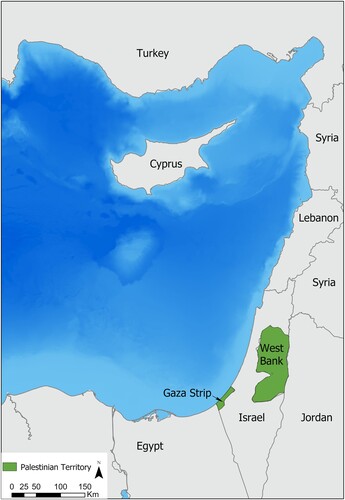
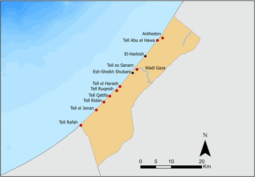
Despite the wealth of available knowledge and the favourable sedimentary conditions outlined above, a different situation characterises the state of maritime archaeology in the Gaza Strip, encompassing over 40 km of the southern Levantine coast. The Gaza Strip, a coastal strip ranging between 6 km and 12 km, comprises an area of c. 365 km2 that can be described as maritime (). Despite the proximity of archaeological sites to the coast of Gaza, the scope of archaeological enquiry has only indirectly engaged with the theories, methods and interdisciplinary discourses of maritime archaeology, apart from a geomorphological study (Morhange et al. Citation2005). Though Gaza lends itself exceptionally well to the approaches outlined above, as well as recent directions in the study of maritime networks that combine new datasets to shed light on mobility, connectivity and conceptual geographies (e.g. Leidwanger and Knappett Citation2018), its incorporation of those studies is impeded by limited access to excavated material, limited opportunity for scientific analyses, and an ongoing ecological and humanitarian crisis (discussed in the following section) that contributes to the rapid deterioration of Gaza’s cultural heritage.
Figure 1. Map showing the location of the Gaza Strip in the Eastern Mediterranean (produced on ArcGIS Pro).
Despite the exceptional vulnerability of maritime archaeology (Erlandson Citation2012; Van De Noort Citation2013), which is aggravated by the ongoing political condition, Gaza’s archaeology is incorporated in discourses on endangered maritime cultural heritage (MCH) to a limited extend (Galili et al. Citation2018b; Recinos and Blue Citation2019). Conflict, economic poverty, restricted access to sites (Keane and Azarov Citation2012–Citation2013), systematic damage and destruction (Taha Citation2019, 36), demographic pressures and associated building development (Armaly Citation2008, 60), lack of funds (Sayej Citation2010, 70), limited capacity and expertise (Al-Houdalieh Citation2009; Mosneaga Citation2021) and limited public awareness (Sayej Citation2010, 62) are factors impeding the documentation, monitoring and management of Gaza’s MCH.
Despite these challenges, encouraging developments led by Palestinian archaeologists have emerged during the past decade (see Yahya Citation2008; Sayej Citation2010, 62) fostering awareness on the value of cultural heritage in Palestine and engaging more closely with other regional experts (Hobson Citation2019; Nikolaus et al. Citation2019; Semaan Citation2020, 186), research organisations and NGOs (e.g., Alby et al. Citation2013; Mosneaga Citation2021).
Palestinian archaeologists have contributed to a substantial inventory of archaeological (and other spatial) information in Palestine (Geomolg), as well as EAMENA’s (Endangered Archaeology of the Middle East and North Africa) active inventory (database.eamena.org), with evaluation of archaeological sites through newly released aerial and satellite imagery. An additional inventory of archaeological sites in the Gaza Strip was updated in 2019 by local archaeologists in collaboration with UNESCO including 268 historical buildings and 86 archaeological sites, 16 of which were not accessible.
With the increasing integration of geospatial technologies in the archaeology of the Near East (Lawrence et al. Citation2020), remote documentation of sites has offered significant opportunities in establishing baseline information and developing monitoring strategies on vulnerable maritime datasets (Andreou et al. Citation2020, Citation2022; Westley et al. Citation2021). Moreover, the combination of satellite imagery with user-generated images has formed the basis of recent counter-cartographical initiatives that map different types of violence in Palestine (Weizman Citation2017), including the destruction of heritage.
This paper combines information from existing site inventories with coastal research, to develop a benchmark for the study of MCH in the Gaza Strip. This study is part of the Maritime Endangered Archaeology in the Middle East and North Africa Project (MarEA). MarEA aims to rapidly document and assess endangered maritime archaeology to produce baseline data that will enhance heritage monitoring and management in the region and highlight further research directions on the coastal and underwater environment (Andreou et al. Citation2020). Documentation is conducted through a combination of bibliographic research and imagery analysis, often supplemented with in-situ observations by local collaborators.
We will first discuss the history of archaeology in the Gaza Strip, followed by a discussion on available imagery and associated challenges. Through these, we will establish the current state of Gaza’s coastline and assess its MCH as documented by Palestinian archaeologists.
Though we acknowledge that similar narratives of looting, neglect and lack of coordination, funding and capacity, illicit digging and current politics emerge also from the West Bank (al-Houdalieh Citation2010, 32–33; Yahya Citation2010a; Citation2010b; Kersel Citation2008; Citation2015), we focus on the Gaza Strip, due to increasing environmental pressures and due to greater limitations on direct international investment.
Archaeology in the Gaza Strip
The Southern Levant is an area with a long scholarly tradition with widely acknowledged links to religion, antiquarianism and colonialism (Meskell Citation1998; Kersel Citation2008; Sayej Citation2010; Greenberg Citation2019; El-Khoudary Citation2019, 91–92). The links between archaeology, nationalism, and identity in Israel and Palestine are well-studied themes (among others Abu El-Haj Citation2001; Benvenisti Citation2002; Ziadeh- Seely, Citation2007; De Cesari Citation2010; Yahya, 2010; Gori Citation2013; Hallote and Joffe Citation2002; Silberman Citation1995; Citation2013; Starzmann Citation2010; Citation2013) and it is not our intention to examine these here. We instead focus on a distinct aspect of Palestinian heritage, MCH (coastal, nearshore, underwater), which appears in abundance in the Gaza Strip.
As a result of the complex legal legacies of antiquities in Palestine, the management of Palestinian cultural heritage has been characterised as fragmented and inconsistent (Kersel Citation2015, 28) or even lacking any real legal framework (Bshara Citation2013, 299). A series of Ottoman laws (1874, 1884, 1906) have been applied in the broader region of Palestine for the protection of archaeological sites and objects (Kersel Citation2008). Following the dissolution of the Ottoman Empire (1917), the colonial British Mandate was established over Palestine and Transjordan, covering the modern territory of Jordan, Israel and the Occupied Palestinian Territories. Referred to as the ‘Golden Age of Archaeology’ (Moorey Citation1991, Chapter 3), investment in the cultural heritage of the region enabled the establishment of formal Antiquities Departments and the Antiquities Ordinance (1929), outlining the process for excavation, analysis, interpretation, storage and display of antiquities (for more information on antiquities Law in Palestine see Kersel Citation2008, Citation2010; Keane and Azarov Citation2012–Citation2013). This period included major excavations in the Gaza Strip, including work by Flinders Petrie at Tell el-Ajjul (Citation1931; Citation1932; Citation1933; Citation1934; Petrie et al. Citation1952).
Following partition in 1948, independent access for Palestinian archaeologists to investigate the strip was limited until 1995, when the Israeli–Palestinian Interim Agreement on the West Bank and the Gaza Strip (Oslo Accords) presented an opportunity for Palestinians to manage their cultural heritage located in at least parts of the Palestinian Territories (Kersel Citation2015, 27). The establishment of the Palestinian Antiquities service (DACH) in 1994 marks the beginning of Palestinian-run field projects, a locally driven scope of legislation, staff training, institution building and protection of sites (Taha Citation2007, 20), as well as a period of unprecedented number of international archaeological expeditions, notably at Tell el-Ajjul (Fischer and Sadeq Citation2001), Tell es-Sakan (de Miroschedji et al. Citation2001) and Blakhiya Anthedon (Humbert Citation2000).
Since the Second Intifada (2000–2005) archaeological activities have ceased or paused, whilst reports from Gaza highlight the impact of conflict on archaeological sites (Abou Jalal Citation2013). Following the 2007 partition of the Gaza Strip, and political divisions between the DACH offices operating in the West Bank and the Gaza Strip, published information on archaeology increasingly became scarce. Subsequent military operations have left a significant footprint of environmental destruction and infrastructural damage, particularly in Gaza City and Rafah, producing a large volume of demolition debris, damages to the sewage system and increase in pollution discharged in the Mediterranean Sea (UNEP Citation2009, 17, map 3; Forensic Architecture and Amnesty International Citation2014).
An important landmark in the history of Palestinian cultural heritage is Palestine’s UNESCO membership in 2011 and ratification of several of its conventions, which was widely considered a crucial step in the protection of Palestinian cultural heritage (Keane and Azarov Citation2012–Citation2013). Critical voices highlighted the importance of this inclusion more on a symbolic than a pragmatic level, with Gaza described as being out of reach (De Cesari Citation2014). This is particularly evident in Gaza’s MCH.
Though Palestine ratified the UNESCO 2001 Underwater Heritage Convention (implemented in 2012) off the shore of Gaza, the prolonged blockade prevents access to most of Palestinian territorial waters, with an estimated 85% of fishing waters being inaccessible (Keane and Azarov Citation2012–Citation2013, 333). The blockade has contributed to Gaza’s economic and humanitarian crisis and is presenting challenges in conducting a detailed documentation and assessment of MCH. Though there are no known underwater excavations off the shore of Gaza, there is an understanding that objects channelled to the antiquities market derive from underwater environments as the result of eroding materials from archaeological sites (Armaly Citation2008, 55). Similarly, published excavations of two Phoenician wrecks in what would be part of Palestine’s EOZ are described as part of the state of Israel (Ballard et al. Citation2002). This paper identifies additional challenges to the coastal landscape of Gaza, deduced through the analysis of aerial and satellite imagery () and cross-referenced with coastal studies conducted by the Islamic University of Gaza.
Table 1. Imagery used for remote assessment.
Imagery Sources
In situ archaeological assessments of coastal and underwater archaeology in the Gaza Strip is exceptionally challenging. Nevertheless, the development of remote geospatial technologies in the archaeology of the Middle East and North Africa region, offers major opportunities for identifying, assessing, and monitoring sites through available historical imagery. It also offers a broader geographical perspective on Gaza’s maritime cultural landscape, where research, like other parts of the Mediterranean, tends to focus on larger or textually prominent sites.
A range of cartographic, aerial photography and satellite imagery sources are available for studying Gaza’s changing landscape and coastal environment. However, several legacy barriers exist to accessing airborne and spaceborne imagery, relating both to accessing some historic archives and US security restrictions on more recent imagery (Zerbini and Fradley Citation2018). The latter restrictions have been recently reformed, and we anticipate important advances in remote-sensing research over the Gaza Strip in the future.
Among the earliest useful cartographic sources for the region is the Palestine Exploration Fund’s (PEF) Survey of Western Palestine drawn up in the 1870s (Conder and Kitchener Citation1883). While lacking the scale and detail of later mapping, this series is useful in identifying archaeological sites and recording toponyms excluded from later maps. The northern Gaza Strip was covered by the Survey of Western Palestine, providing some archaeological data in terms of mapped sites and indicative toponyms. Important details can be gleaned from earlier mapping of the region, such as Grimm and Malmann’s (Citation1850) Atlas of Palestine and the Sinai Peninsula and British intelligence mapping from 1841 (TNA, MPK 1/294/2–8).
Gaza became a focus of aerial mapping during WWI, particularly ahead of the Third Battle of Gaza, where photogrammetric topographical mapping from aerial photographs was deployed successfully (Collier Citation2014). Little interest was taken in archaeological aspects of the landscape by cartographers, and very little of the original photography from this period survives. The bulk of the British aerial photographic archive from WWI began to deteriorate in the 1920s and was discarded (TNA, OS 1/384). Small numbers of resulting prints have survived in private collections, including a group covering Gaza shared with the EAMENA project ahead of this research, while more complete archives taken by Australian squadrons are preserved at the Australian War Memorial in Canberra (https://www.awm.gov.au/). Photographs taken over British military bases in 1918 by German aircrews are accessible online in the Bayerisches Hauptstaatsarchiv (https://www.gda.bayern.de/).
Mapping in the region increased under the Survey of Palestine during the interwar period. Outputs included a range of map series covering Gaza at a range of scales. There is some evidence that aerial photography collected by the RAF assisted the work of the Survey of Palestine, although only fragments of this material are known to have survived (MEC, GB165–0187). Map sheets from this period are valuable in identifying archaeological sites, structures or features that now, decades later, are considered cultural heritage.
In the mid-1940s, 680 Squadron RAF undertook a systematic survey of Mandate Palestine, covering the territory with overlapping vertical photography taken at approximately 15,000 feet (c. 4,500 m). A collection of degraded prints from these missions are now held at the Hebrew University of Jerusalem, with the original negatives housed at the National Collection of Aerial Photography (NCAP) in Edinburgh. Neither collection is fully open access, whilst some have deemed the NCAP negatives as inaccessible for research (Weizman Citation2020). Sections are published in low resolution in Salmn Abu Sitta’s (Citation2010) Atlas of Palestine, 1917-1966.
The principal imagery sources for the later part of the 20th century are declassified US imagery, broadly the Corona missions (1960s) and the Kh9 Hexagon missions (1970s). The area was likely also covered by the U2 reconnaissance flights from the late 1950s, but the US authorities have yet to declassify any missions that passed over Israel (Hammer and Ur Citation2019). Higher resolution commercial satellite imagery is available from the early 2000s, but imagery captured by US satellites was until recently, restricted by the Kyl–Bingaman Amendment (Zerbini and Fradley Citation2018). Imagery scenes of Gaza are available on the Geomolg system. Satellite images have also been made available by the soar.earth platform during the 2021 conflict, including a full-coverage scene of the Gaza Strip.
Though often fragmentary and poorly preserved, historical imagery from the Gaza Strip offers a valuable record for identifying landscape changes, particularly at the coastal zone. In this paper, we compared imagery from multiple periods (), largely covering the years between 1870 and 2021, with an emphasis on landscape alterations between 1971 and 2021, where frequency of capture and resolution allows more accurate observations.
Before discussing existing sites in detail, it is necessary to contextualise maritime archaeology in the broader environment, which has been examined extensively through the lens of coastal research.
Current State of the Coastline
The coast of the Gaza Strip encompasses a diverse geological and geomorphological area, with the north and south typified by sand dunes, and the middle/centre of the strip comprised of coastal cliffs. The seashore and the sand dunes have been described as the ‘only natural and recreational areas in Gaza Strip’ (Abd Rabou Citation2017, 37) and are now places with dense recreational infrastructure. Parts of the coastal strip, particularly around the area of El-Mawassi, are used for agricultural purposes.
A common characteristic in coastal scientific research in Gaza is the extensive use of remote sensing (summary in Abualtayef et al. Citation2021, 2), which reflects the necessity to respond to issues resulting from the limited access of Palestinians to the water off the Strip. Remote sensing has been used to estimate shoreline change between Wadi Gaza to Al-Sodania between 1972 and 2010 (Abualtayef et al. Citation2013), the whole coast between 1972 and 2014 (Abualtayef et al. Citation2021), and the nearest coast to Gaza City between the 1980s and 2009 (Alhin and Niemeyer Citation2009).
Common themes in Gaza’s coastal research include aggravated erosion (identified across > 60% of the shoreline between 1972 and 2014) particularly at the Egyptian border, but also instances of coastal accretion resulting from construction and development (industrial harbours, leisure infrastructure), as for example at the Gaza harbour. Abualtayef et al. (Citation2021,10) documented decreasing trends in sandy beaches and increasing trends in built-up areas and agricultural land, partly associated with the 2005 Israeli withdrawal from the area (Abd Rabou Citation2017, 76). Those changes were evident in imagery between 2004 and 2016 and possibly linked to housing projects in Khan Younis and Rafah (Abu Rabou Citation2017, 77). The correlation between overpopulation (Alhin and Niemeyer Citation2009), building construction, sand mining and coastal erosion in Gaza is well-stablished in existing literature (Zviely and Klein Citation2003; UNEP Citation2009).
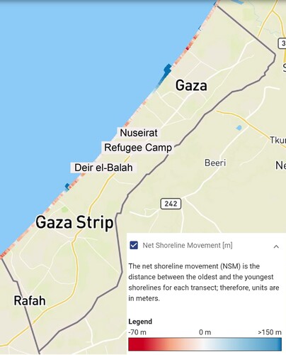
These observations are corroborated by a recently concluded UNDP project that has calculated a linear regression rate-of-change for the coastline of Gaza strip, quantifying annual rate of change (Klinger and Knauer Citation2020; EO Clinic Gaza (eoapp.de)). Though the quantified results may not be precise for small-scale observations, they offer important indications for long-term trends in coastline alteration. They suggest a general trend toward a negative shoreline movement, in what has been calculated up to 70 m between 1990 and 2020 (). They also highlight associations between negative coastline alteration with anthropogenic factors, typical in the Mediterranean region, such as dam construction and artificial coastal structures. These factors have long been stressed in coastal research in Gaza (Abualtayef et al. Citation2012, 1), which has highlighted the association of increasing erosion with sediment deficiency in the eastern Mediterranean following the construction of the Aswan dams (1902, 1964). Additional factors contributing to erosion are the construction of groins in 1972, the 1978 construction and subsequent removal of breakwaters, and the development of Gaza harbour in 1994–1998. One can observe the accumulation of land south of the harbour, as a result of trapped sediment and land reclamation (disposal of construction waste), but also erosion (>1 m/annum) to the north of the harbour. Sediment accumulation was noted on the north border of the Gaza strip, probably trapped due to the sea barrier constructed in 2018—a barrier that stops the counter-clockwise transportation of sand from the Nile Delta (Shtienberg et al. Citation2014).
Figure 2. Map showing net shoreline movement between 1990 and 2020 (adopted from www.undp.gaza.eoapp.de).
These studies tend to address the environmental impact of coastline alteration (Abd Rabou Citation2013; MEnA Citation2001) on marine biodiversity, pollution, as well as the economic impact on the fishing and tourist industries. They also identify the main challenges in the environmental management of Gaza’s shoreline, including the ineffective and unsustainable management of coastal and marine ecosystems, pollution, and degradation, increasing demand of land, outdated fishing equipment, limited fishing zones (and associated overfishing), and coastal development including ports, power stations and desalination plans (Abd Rabou Citation2017, 18). Notably, Abd Rabou (Citation2017) stresses the need for more detailed geospatial data concerning Gaza’s coastal and marine environment, establishment of regular coastal assessment and monitoring strategies, development of local expertise on remote sensing, and funding for bathymetric surveys. The same aspects of infrastructure and capacity building are necessary for the management of MCH and could, in fact, be developed in conjunction with coastal management strategies. However, despite extensive studies on the state of Gaza’s coastline by researchers, international organisations, NGOs (Mosneaga Citation2021) and government bodies (MOPIC Citation1996; MEnA Citation2001), the relationship between coastal alterations and MCH remains under-explored.
The Current State of Maritime Archaeology
In this paper we are looking at evidence for pre-modern human activity on the modern coastline, and near ancient shorelines as indicated by geomorphological studies. Additional archaeological evidence in the Gaza Strip has been documented not in direct association with the coastline. Though these sites may not contribute to the reconstruction of the materiality of maritime activities, they offer important insights into broader economic and social networks that often extend beyond the immediate coastal zone. For these sites, we include brief notes on damage noted in imagery between 1971 and 2021 ( and ).
Table 2. Summary of observations on Gaza Strip’s archaeological sites.
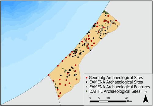
For this study, we combined information from the Geomolg, the EAMENA and the Digital Archaeological Atlas of the Holy Land (DAAHL) databases. We subsequently enhanced it with published information, resulting in 93 archaeological sites (). Some of the better-known sites were excavated during the British Mandate in Palestine and between 1994 and 2001. Others are assumed to have been documented by local authorities since 2001. EAMENA researchers have identified an additional 43 archaeological features in historic maps (e.g., cisterns, fountains, burials, historical buildings), while Palestinian trainees participating in workshops funded by the Cultural Protection Fund have added in the EAMENA database features associated with toponyms suggestive of premodern activities. These include sites, the name of which contains the word Khirbet (=ruin) and Tell (=mound), as well as areas (documented on maps from the Survey of Western Palestine and the 1:20,000 output of the Survey of Palestine) suggestive of rural Sheikhs’ tombs, holy sites, tombs and cemeteries that have acquired significance in their local communities (Frantzman and Bar 2013). Finally, DAHHL has mapped pre-Mandate villages documented by the Western Palestine survey, which could be classified as Late Islamic (Ottoman) or Contemporary Islamic (Early 20th century).
Figure 3. Documented archaeological sites and features (produced on ArcGIS Pro).
Wadi Gaza
The examination will start from Wadi Gaza, an important historical landmark (Humbert and Sadeq Citation2000; Sadeq Citation2014), surrounded by archaeological sites that have been explored more extensively (). The coastal wetlands of Wadi Gaza are a fragile environment included in UNESCO’s tentative list, up until recently experiencing disturbances due to the discharge of raw sewage into the wadi (UNEP Citation2009, 41–42 and Map 10) and the use of the surrounding landscape as a waste dump site (UNEP Citation2009, 50). Geomorphological changes around the mouth of the Wadi are visible when comparing imagery between 1971 and 2021 (). Though pollution would make challenging any underwater archaeological, terrestrial and marine geophysical survey, the recent removal of the sewage plants will alleviate some of the challenges involved in archaeological work at Wadi Gaza.
Figure 4. Map showing archaeological sites along Wadi Gaza. Note also different imagery resolution between scale restricted, publicly available imagery from Google Earth and imagery granted by the European Space Agency (produced on ArcGIS Pro).
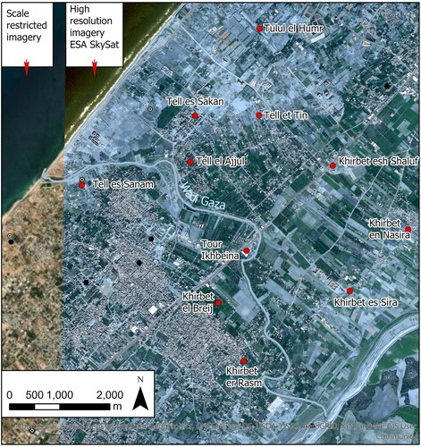
Figure 5. Landscape changes around the mouth of Wadi Gaza between 2003 and 2021 (produced on ArcGIS Pro using publicly available imagery from geomolg.ps).
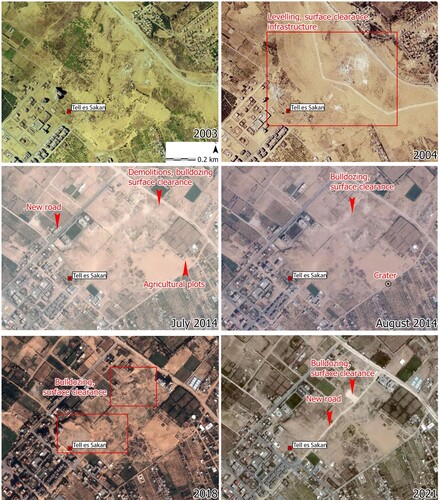
According to Morhange et al. (Citation2005), presently inland sites such as the Chalcolithic and Early Bronze Age Taur Ikhbeineh and the Bronze Age Tell es-Sakan were likely coastal or near coastal in antiquity. Tell es-Sakan (3500–2350 bce), located in Wadi Gaza’s riverbank likely had its harbour in a palaeo-channel (de Miroschedji et al. Citation2001; Morhange et al. Citation2005). Based on available imagery, Tell es-Sakan appears to have experienced significant landscape alterations, particularly between 2003 and 2004, and between 2005 and 2014. The (now backfilled) surface of the site has been altered through the carving of tracks, bulldozing visible on 2018 imagery, associated by some with reported military use (Smith Citation2017), as well as the demographic pressures visible in the expansion of houses and agricultural plots around the site ().
Figure 6. Landscape changes around Tell es Sakan between 2003 and 2021 (produced on ArcGIS Pro using publicly available imagery from geomolg,ps).
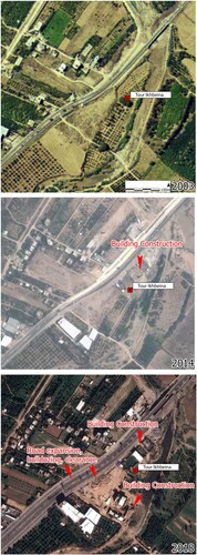
Taur Ikhbeineh presently 3 km inland, adjacent to Wadi Gaza and dating to the 4th–3rd millennia bce (Oren and Yekutieli Citation1992; de Miroschedji et al. Citation2001) was also likely coastal or near coastal in antiquity (Morhange et al. Citation2005). Following its excavations in the late 1980s and until 2004 the area was used agriculturally. Imagery from 2004 suggests initial building developments in the area, while more recent activity includes land clearance potentially to accommodate further construction ().
Figure 7. Landscape changes around Taur Ikhbeineh (also Tour Ikhbeineh) between 2003 and 2021 (produced on ArcGIS Pro using publicly available imagery from geomolg.ps).
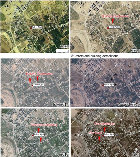
Currently in Wadi Gaza’s bed, the MBA–LBA Tell el-Ajjul is one of the most extensively examined archaeological sites in Gaza, described as an estuarine landscape in the Bronze Age (Morhange et al. Citation2005). Tell el-Ajjul is now used agriculturally (El Khoudary Citation2019, 92), as corroborated by recent satellite imagery. Land clearance can be observed between 2003 and 2004, and by 2014 an increasing number of structures were built (). Craters and building demolitions have been noted on and near Tell el-Ajjul on imagery from August 2014 (but not visible on imagery from July 2014), which coincides with the 2014 Gaza War.
Figure 8. Landscape changes around Tell el-Ajjul between 2003 and 2021 (produced on ArcGIS Pro using publicly available imagery from geomolg.ps).
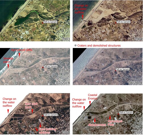
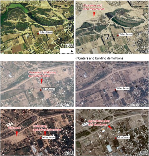
Further to the West, at the entry of the estuary, archaeologists noted Iron Age surface finds at Tell es-Sanam (Morhange et al. Citation2005; Sadeq Citation2012). The surrounding landscape has completely transformed between 2005 and 2014, with the building of several industrial facilities on the wadi mouth and alluvial fan, and agriculture-related buildings within the estimated area of the site ( and ). Evidence for building demolitions and craters near and around Tell es-Sanam has been noted in imagery captured in July and August 2014. These coincide with the 2014 Gaza War, with confirmed incidents of bombing of the coastal zone (near Khan Yunis). Though Wadi Gaza lends itself well to a study of the diachronic engagement of people with the sea, the drastic alteration of its surrounding landscape challenges the collection of geomorphological data (geophysical or coring).
Figure 9. Landscape changes around Tell es-Sanam between 2003 and 2021 (produced on ArcGIS Pro using publicly available imagery from geomolg.ps).
Modern Gaza and Environs
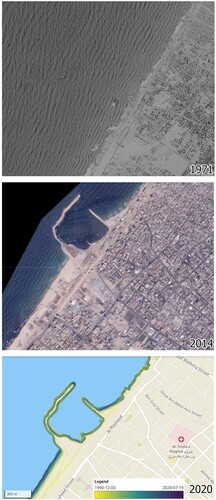
The area directly NE and adjacent to the modern Gaza harbour has experienced dramatic coastal erosion, quantified by Klinger and Knauer (Citation2020) between 40 m and 50 m over the past 30 years (). In this area and further to the north, Palestinian trainees collaborating with the EAMENA have identified MCH dating to the Roman, Byzantine and Late Islamic periods. These are periods with more extensive textual evidence that highlights the role of this coastline in Levantine maritime networks (Obied Citation2016, 129–30). Byzantine sources mention the harbour of Gaza (among others), including references to land networks connecting coastal sites along the Syro-Palestinian coast (Yasur-Landau et al. Citation2018, 80). In addition, material evidence suggests the key role the southern Levant played in the export of wine during the 5th century ce with Gaza and Ashkelon jars excavated in central and western Europe, including England (Johnson and Stager Citation2008). This location corresponds to the general area between Gaza and Anthedon, discussed below.
Figure 10. Landscape changes around the Gaza harbour between 1971 and 2020 (produced on ArcGIS Pro using purchased Corona Imagery, publicly available imagery from geomolg.ps and adopted illustration from www.undp.gaza.eoapp.de).
Further to the NE, Tell Abu el-Hawa is an area of multiperiod premodern activity (geomolg.ps). Unlike its densely built surroundings, the area likely corresponding to the Tell was only temporarily covered by a structure constructed and abandoned between 2004 and 2014. Like the rest of the coastline NE of Gaza harbour, it has experienced severe coastal erosion.
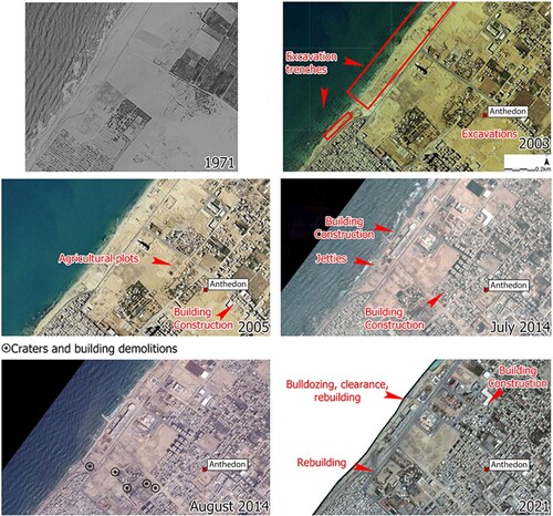
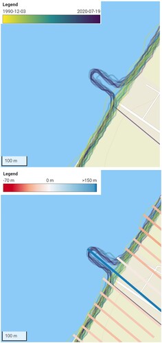
Near the Beach refugee camp, the site of Anthedon is located directly on the beachfront (Humbert and Sadeq Citation2000, 107). The exposed and backfilled archaeology of Anthedon, including features dispersed in inland locales (Nabulsi et al. Citation2010) and probably associated with a range of underwater components is included in UNESCO’s tentative list. Photographs of the site indicate exposure to coastal erosion, something corroborated by coastal studies that suggest an annual land loss ranging between 40 cm and >100 cm (). Additional disturbances include bulldozing and surface clearance to accommodate agricultural plots and structures (2004), the creation of breakwaters and extensive building construction between 2005 and 2014, craters visible on imagery in August 2014, some of which are near excavation trenches, and subsequent building and infrastructure reconstructions (2015–2021) (). Though the extent of the different chronological components of Anthedon are not known, many archaeological features are likely presently underneath modern buildings. Despite the current state of the site, the coastal scarp, the nearshore area and the seabed present both significant opportunities and an urgent need for a systematic seabed mapping and a broader maritime archaeological study. Though due to the presence of military activity around Anthedon, archaeological documentation is challenging, Forensic Architecture (Goldsmith University) has recently combined drone imagery with archival photos for a virtual excavation of Anthedon, highlighting also its broader archaeological landscape (Forensic Architecture, personal communication 18 October 2021).
Figure 11. Shoreline change and movement between 1990 and 2020 on the coast of Anthedon harbour (adopted from www.undp.gaza.eoapp.de).
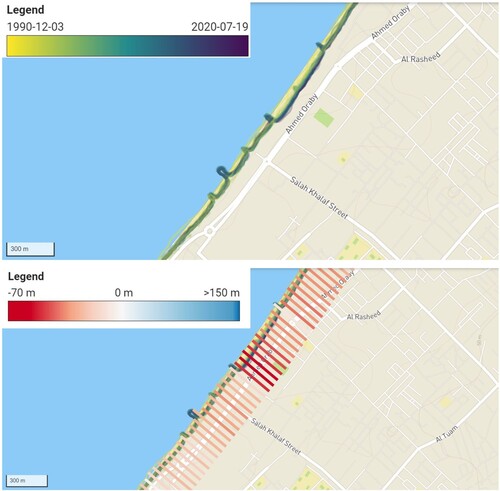
Figure 12. Landscape changes around Anthedon harbour between 1971 and 2021 (produced on ArcGIS Pro using purchased Corona Imagery and publicly available imagery from geomolg.ps).
The coastal area around and NE of the modern Gaza harbour is generally examined in conjunction with the Old City of Gaza. Largely demolished and rebuilt during the 20th century, the Old City of Gaza is an area with a longstanding human presence, aspects of which are preserved in individual buildings and neighbourhoods (Clarke et al. 2004; Sadeq Citation2015). The city of Gaza has been the theatre of hostilities with most recently the 2021 conflict, resulting in the demolition of buildings and the creation of massive amounts of debris. In this paper we only examined the locations around archaeological sites with the aim to note any association between potential damage and cultural heritage. Despite the severe impact of conflict in the city, the main challenge in identifying pre-modern material evidence in Gaza is urban expansion—an issue arising from limited space as a result of the ongoing blockade and conflict. The same applies for Jabaliya, Beit Hanoun and Beit Lahiya located NE and E of Gaza city, all of which were existing villages before the British Mandate in Palestine (1948) and have since expanded to larger towns.
North Border—Naval Barrier
At the northern-most end of the Gaza Strip (), DAAHL has mapped sites identified by the Israel Antiquities Authority. Some of these sites, located along the North border with Israel, were originally surveyed in 1972–1973, resurveyed in 1995 and published in 2004 (http://www.antiquities.org.il/survey/new/default_en.aspx?pid = 175#EditFor). The surface remains south of the border are multi-period and range between the Neolithic and the Ottoman Era. Though no coastal structures have been documented, Byzantine potsherds and coins were noted on the beach, along with architectural stones, marble fragments and roof tiles from other chronological periods. Like most of the coastline of the Gaza Strip, this area is experiencing severe erosion (). The adjacent seabed is also disturbed by the 200 m naval barrier constructed in 2018–2019. This barrier acts as sediment trap, which decreases the rate of coastal erosion, but also covers any underwater material remains ().
Figure 13. Shoreline change and movement between 1990 and 2020 on the northern border of the Gaza Strip, adjacent to the naval barrier (adopted from www.undp.gaza.eoapp.de).
SW of Wadi Gaza
Moving to the SW of Wadi Gaza, multiperiod premodern human activities are likely at Tell el-Harrash (geomolg.ps), a coastal location that has experienced both coastal erosion and accretion, the latter related to land reclamation. Though the spatial extent of premodern human activities is unknown, several modern (likely agriculture related) structures are noted within the broader area of the tell. Tell el-Harrash requires further examination to establish a more precise chronology and identify associated maritime activities.
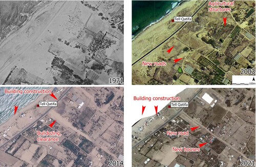
Further to the south, Tell Ruqeish, is an Iron Age site near a silted-up bay (Oren Citation1993; Morhange et al. Citation2005, 78). The associated coastline has experienced severe erosion and extensive construction. Tell Ruqeish would benefit from a detailed documentation of its exposed coastal scarp. South of Tell Ruqeish, a jetty was constructed at some point between 2015 and 2018.The area south of the jetty has experienced alterations due to sediment accumulation and the area north of the jetty has experienced aggravated erosion. Directly adjacent to the jetty is the Neolithic Tell Qatifa (Eptstein Citation1984), now surrounded by reclaimed land obscuring and potentially protecting any underwater material remains (). Further examination of Tell Qatifa could help reconstruct prehistoric mobility patterns and contribute to important discussions on (elsewhere submerged) prehistoric landscapes.
Figure 14. Landscape changes around Tell Qatifa between 1971 and 2021 (produced on ArcGIS Pro using purchased Corona Imagery and publicly available imagery from geomolg.ps).
About 2.5 km south of Tell Qatifa and along the coast, a possible Iron Age stone quay has been reported at Tell Ridan (Raban and Galili Citation1985, 329–32)—an area presently covered by modern structures. The general area was covered by more extensive building, later removed (with associated bulldozing and surface clearance) at some point between 2005 and 2014. Due to the exposure of Tell Ridan to erosion, it is estimated to have experienced an annual loss of land of >1 m during the past 50 years. This likely removed the maritime infrastructure noted 30 years ago, along with other evidence for pre-modern maritime activities, often not accompanied by built/artificial infrastructure during the Bronze and Iron Ages (Yasur-Landau et al. Citation2018, 77).
Further to the SW and along a coast used by traditional fishing boats, Tell el-Jenan (geomolg.ps) is a coastal mound with evidence for premodern human presence. Though the precise location of the site is unclear, the general area contains modern structures and agricultural fields. Like most of the coast near Khan Younis, it has experienced high rates of erosion.
At the border with Egypt, Tell Rafah (historic Raphia, Obied Citation2016, 138–39) is located at one of the actively eroding coastlines of the Gaza Strip. Erosion appears particularly aggravated after the 2010 construction of sea groins 2 km west of the border and extending almost 1 km seaward (Abualtayef et al. Citation2021, 3). The coastal zone is now covered by modern structures (). Archaeological evidence dating between the Bronze Age and the early 20th century has been documented within the city of Rafah, further inland—an area drastically altered by modern development, and significantly damaged during the 2008–2009 (UNEP Citation2009, 17, map 3, 23, map 7) and the 2014 conflicts (Weizman Citation2017, 186–90).
Figure 15. Landscape changes around Tell Rafah between 2003 and 2021 (produced on ArcGIS Pro using publicly available imagery from geomolg.ps).
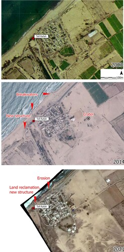
Figure 16. Map of coastal archaeological sites in the Gaza Strip (produced on ArcGIS Pro).
Beyond the coastal zone, several sites have been explored to differing extents. Though not possible to discuss those in detail, we summarise our observations, accompanied with relevant literature on . This information is accessible via the EAMENA database, including the coordinates of the sites.
Conclusions and Future Directions
Though research on Levantine maritime archaeology has expanded over the past few decades, significant maritime hubs on the Levantine coast remain poorly understood. One such place is the Gaza Strip, an area with limited funds and ongoing political issues (including marine blockade), exacerbating its demographic, economic, humanitarian and ecological crises. The maritime archaeology of the Gaza Strip is limited by severe challenges in the identification, documentation, further analysis and management of archaeological features. It is unlikely that this situation will substantively change in the future in the context of the Israeli blockade. We also anticipate that it will be further exacerbated by the impact of climate change and the Grand Ethiopian Renaissance Dam. The latter is the first hydroelectric dam system to be constructed on the Nile since the Aswan High Dam in the 1960s. Once it becomes fully operational it will affect the Nile hydrological system downriver (Wheeler et al. Citation2020).
Though maritime archaeological research in the Gaza Strip is close to non-existent, excavated and known MCH, combined with research on Gaza’s coastline present significant opportunities to examine the history of human engagement with the sea. Creating a benchmark for the study of MCH in Gaza highlights interpretive shortcomings due to site condition and preservation. It also helps heritage practitioners on the ground to prioritise site monitoring and management. Furthermore, MarEA’s and EAMENA’s inventory of archaeological and environmental data (database.eamena.org) offers a wide array of interim opportunities to expand existing research on palaeo-geography, to broaden research on low-cost, sustainable methods for site documentation, and to develop rigorous theoretical discussions on the relation between site preservation and archaeological narratives (CitationFigure 16).
Based on the present inventory, most maritime archaeological sites in Gaza are directly affected by erosion and building development (), both of which cannot be viewed separately from Gaza’s political situation. Coastal erosion constantly exposes and eliminates archaeological contexts on the coastal scarp, the excavation of which requires significant amount of funds and labour that are not available. Moreover, building development becomes a priority under the unique demographic pressures characterising this region.
Table 3. Damage and disturbances on maritime archaeological sites in the Gaza Strip.
Though limited funds prevent the systematic excavation of maritime sites and underwater explorations are not permitted, regular documentation of the coastal scarp has been used in the archaeology of the MENA region to produce an accurate record of eroding archaeological contexts (e.g., Andreou et al. Citation2017; Andreou Citation2018; Pourkerman et al. Citation2018). Such record would offer information on archaeological features otherwise destroyed without documentation. Though such attempts have recently focused on Anthedon, less extensively documented sites such as Tell-Ridan, Tell Ruqeish and Tell Qatifa present significant opportunity for rapid documentation and subsequent enhancement of existing narratives on historical engagement with the sea. Similarly, an inventory of iconographic representations and written sources on maritime activities within the area of research, offer important indications of historical perceptions of the ancient coastal landscape (e.g., Obied Citation2016) and indications on the location and materiality of premodern shorelines. The inventory of these locations is currently under preparation and will be published at a later stage.
Beyond the modern coastal zone, apart from the old city of Gaza and a small number of villages dating during and before the Ottoman Era, the direct impact of conflict (air strikes, demolitions) does not seem to have extensively affected archaeological sites (). Like the coastal zone, however, the indirect impact of conflict, such as the housing crisis is identified as the main factor affecting the archaeological preservation.
Table 4. Damage and disturbances on documented archaeological sites across the Gaza Strip.
Though not possible to examine all known archaeological features found within densely built-up areas, the examination of historical maps offers valuable information on premodern human activities in the Gaza Strip. Establishing a baseline for the study of MCH in Gaza, including site location, available bibliographic and imagery sources, noted disturbances and coastal vulnerability, offers a valuable tool in prioritising site monitoring, establishing more targeted documentation strategies, but also encouraging a closer collaboration between heritage practitioners and coastal scientists that both share an interest in the preservation of Gaza’s landscape—a rich source of environmental and cultural history.
Acknowledgements
This research was conducted as part of the MarEA project, in collaboration with the EAMENA project, both generously funded by the Arcadia Fund, a charitable fund of Lisbet Rausing and Peter Baldwin. We would like to thank Mohammad Jaradat, who has identified, assessed and uploaded archaeological sites in the EAMENA database as part of training funded by the Cultural Protection Fund. We are also grateful to Mrs Yasmeen El-Khoudary for her comments on earlier versions of this paper and for ground-verifying our observations.
Disclosure statement
No potential conflict of interest was reported by the authors.
Additional information
Funding
Notes on contributors
Georgia M. Andreou
Georgia Andreou is a researcher at the University of Southampton and an associate lecturer at the Institute of Archaeology, UCL. Her interests include Mediterranean prehistory and archaeological legacies of the Near East.
M. Fradley
Michael Fradley is a landscape archaeologist whose recent work with the EAMENA project has focused on using remote sensing techniques to survey and monitor archaeological sites in the Middle East.
L. Blue
Lucy Blue is a lecturer at the University of Southampton and co-director of the MarEA project. She is also the part-time maritime archaeological director of the Honor Frost Foundation.
C. Breen
Colin Breen is a Reader in the School of Geography and Environmental Sciences, Ulster University, and co-director of the MarEA project. His research interests include maritime societies, environmental change and conflict.
References
- Abd Rabou, M. A., 2013. ‘Priorities of Scientific research in the Fields of Marine Environment and Fishery Resources in the Gaza Strip – Palestine’, in Scientific Research Affairs (ed.), Priorities of Scientific Research in Palestine: Towards a National Directory of Scientific Research, March 25-26, 2013, Gaza: Islamic University of Gaza: 481—822.
- Abd Rabou, M. A., 2017. Assessing and Mapping the Coastal Zone Changes in the Gaza Strip, Palestine, Using GIS and Remote Sensing Techniques (unpublished MA thesis), The Islamic University of Gaza, Gaza.
- Abou Jalal, R., 2013. ‘Gaza’s ancient ruins neglected, looted’. Al-Monitor [online] 10 October 2013 [Accessed 13 October 2021]. Available at: https://www.al-monitor.com/originals/2013/10/gaza-archaeology-ruins.html
- Abu Amer, A., 2021. ‘New archaeological discovery in St. Hilarion Monastery’, Al-Monitor [online] 13 April 2021 [Accessed 12 July 2021]. Available at: https://www.al-monitor.com/originals/2021/04/new-archaeological-discovery-st-hilarion-monastery
- Abu El-Haj, N., 2001. Facts on the Ground: Archaeological Practice and Territorial Self-fashioning in Israeli Society, Chicago: University of Chicago Press.
- Abu Sitta, S. H., 2010. Atlas of Palestine, 1917-1966, London: Palestine Land Society.
- Abualhin, K., and Neimeyer, I., 2018. ‘Deriving Bathymetric Maps of the Shallow Coastal Water of the Gaza Strip Coastal Zone Using Passive Remote Sensed Imagery’, Journal of the Indian Society of Remote Sensing 46(9), 1341—51.
- Abualtayef, M. et al., 2013. ‘Mitigation Measures for Gaza Coastal Erosion’, Journal of Coastal Development 16(2), 1—13.
- Abualtayef, M. et al., 2021. ‘Change Detection of Gaza Coastal Zone Using GIS and Remote Sensing Techniques’, Journal of Coastal Conservation 25(36), 1—20.
- Abualtayef, M. et al., 2012. ‘The impact of Gaza fishing harbour on the Mediterranean coast of Gaza’, Journal of Coastal Development 16(1), 1—10.
- Aharoni, Y., 1974. ‘Survey between Raphia and the Brook of Egypt, A: The Survey’, ʿAtiqot 7, 88–90 (Hebrew, English summary p. 14).
- Alby, E., et al., 2013. ‘Close Range Photogrammetry Applied to the Documentation of an Archaeological Site in Gaza Strip, Palestine’, International Archives of the Photogrammetry Remote Sensing and Spatial Information Sciences, Volume XL-5/W2, 19–24.
- Alhin K. A., and Niemeyer, I., 2009. ‘Coastal Monitoring Using Remote Sensing and Geoinformation Systems: Estimation of Erosion and Accretion Rates along Gaza Coastline’, IEEE International Geoscience and Remote Sensing Symposium 4, 29–32.
- Al-Houdalieh, S. H., 2009. ‘Archaeology Programs at the Palestinian Universities: Reality and Challenges’, Archaeologies 5(1), 161–63.
- Al-Houdalieh, S. H., 2010. ‘Archaeological Heritage and Related Institutions in the Palestinian National Territories 16 Years After Signing the Oslo accords’, Present Pasts 2(1), 31–53.
- Andreou, G. M. et al., 2017. ‘Integrated Methods for Understanding and Monitoring the Loss of Coastal Archaeological Sites: The Case of Tochni-Lakkia, Cyprus’, JArchaeolSciRep 12, 197–208.
- Andreou, G. M. et al., 2020. ‘Maritime Endangered Archaeology of the Middle East and North Africa – MarEA’, Antiquity 94(378), E36, 1–7. doi:10.15184/aqy.2020.196.
- Andreou, G. M. et al., 2022. ‘Big Data in Maritime Archaeology: Challenges and Prospects from the Middle East and North Africa’, Journal of Field Archaeology DOI: 10.1080/00934690.2022.2028082
- Andreou, G. M., 2018. ‘Monitoring the Impact of Coastal Erosion on Archaeological Sites: The Cyprus Ancient Shoreline Project’, Antiquity 92(361), E4. DOI:10.15184/aqy.2018.1.
- Armaly, F., 2008. ‘Crossroads and Contexts: Interviews on Archaeology in Gaza’, Journal of Palestine Studies 37(2), 43–81.
- Ballard, R. D. et al., 2002. ‘Iron Age Shipwrecks in Deep Water off Ashkelon, Israel’, AJA 106(2), 151–68.
- Ben-Bassat, Y., and Buessow, J., 2020. ‘Applying Digital Methods to the Study of a Late Ottoman City: A Social and Spatial Analysis of Political Partisanship in Gaza’, Journal of Economic and Social History of the Orient 63, 505–54.
- Benvenisti, M., 2002. Sacred Landscape. The Buried History of the Holy Land Since 1948, Berkeley: The University of California Press.
- Brandl, D., and Brandl, B., 2010. Deir El-Balaḥ: Excavations in 1977-1982 in the Cemetery and Settlement, Qedem 49–50, Jerusalem: Institute of Archaeology, Hebrew University of Jerusalem.
- Bshara, K., 2013. ‘Heritage in Palestine: Colonial Legacy in Postcolonial Discourse’, Archaeologies: Journal of the World Archaeological Congress 9(1), 295–319.
- Çelik, Z., and Azarbadegan, Z., 2020. ‘Late Ottoman Visions of Palestine: Railroads, Maps, and Aerial Photography’, Jerusalem Quarterly 82, 87–109.
- Clarke, J., Steel, L., and Sadeq, M., 2001. ‘Gaza Research Project: 1998 Survey of the Old City of Gaza’, Levant 36(1), 31–36.
- Collier, P., 2014. ‘Mapping for the Third Battle of Gaza, 1917’, in H. Goren, E. Dolev and Y. Sheffy (eds), Palestine and World War I: Grand Strategy, Military Tactics and Culture in War, London: Tauris, 153–71.
- Conder, C. R., and Kitchener, H. H. (eds) 1883. The Survey of Western Palestine. Memoirs of the Topography, Orography, Hydrography and Archaeology, London: Palestine Exploration Fund.
- DAAHL, The Digital Archaeological Atlas of the Holy Land Available at: The Digital Archaeological Atlas of the Holy Land (ucsd.edu).
- Davis, R. A., and Hayes, M. O., 1984. ‘What is a Wave-Dominated Coast?’, Marine Geology 60, 313–29.
- De Cesari, C., 2010. ‘Creative heritage: Palestinian heritage NGOs and defiant acts of government’, American Anthropologist 112(4), 625–37.
- De Cesari, C., 2014. ‘World Heritage and the Nation-State: A View from Palestine’, In C. De Cesari and A. Rigney (eds), Transnational Memory: Circulation, Articulation, Scales, Berlin: De Gruyter, 247–70.
- El Safadi, C., and Sturt, F., 2019. ‘The warped sea of sailing: Maritime topographies of space and time for the Bronze Age eastern Mediterranean’, JAS 103, 1–15.
- El-Khoudary, Y., 2019. ‘Gaza’s Historical Cycles of Prosperity and Destruction. Is the Present an Aberration?’, in H. Yacobi and M. Nasasra (eds), Routledge Handbook on Middle East Cities, London: Routledge, 89–103.
- Endangered Archaeologies of the Middle East and North Africa Database, database.eamena.org.
- Epstein, C., 1984. ‘A Pottery Neolithic Site Near Tel Qatif’, IEJ 34(4), 209–19.
- Erlandson, J. J., 2012. ‘As the World Warms: Rising Seas, Coastal Archaeology, and the Erosion of Maritime History’, Journal of Coastal Conservation 16(2), 137–42.
- Fischer, P., and Sadeq, M., 2001. ‘Tell el-Ajjul 1999. First Season Preliminary Report’, Egypt and the Levant 10, 211–26.
- Forensic Architecture and Amnesty International, 2014. ‘The Gaza Platform: An Interactive Map of Israeli Attacks during the 2014 Gaza Conflict’ [online]. http://gazaplatform.amnesty.org [accessed 10 October 2021].
- Frantzman, S. J., and Bar, D., 1997. ‘Mapping Muslim Sacred Tombs in Palestine During the Mandate Period’, Levant 45(1), 96–111.
- Galili, E. et al., 2019. ‘A submerged 7000-year-old village and seawall demonstrate earliest known coastal defense against sea-level rise’, PLoS ONE, 14. e0222560. https://doi.org/10.1371/journal.pone.0222560
- Galili, E. et al., 2007. ‘Beach Deposits of MIS 5e High Sea Stand as Indicators for Tectonic Stability of the Carmel Coastal Plain, Israel’, Quaternary Science Reviews 26(19–21), 2544–57.
- Galili, E. et al., 2018a. ‘The archaeology and paleoenvironment of the submerged Pottery Neolithic settlement of Kfar Samir (Israel)’, Paléorient 44, 113–32.
- Galili, E. et al., 2020. ‘Israel: submerged prehistoric sites and settlements on the Mediterranean coastline—the current state of the art’, in G. Bailey et al., (eds), The Archaeology of Europe’s Drowned Landscapes, Coastal Research Library, Volume 35, Cham, Switzerland: Springer 443–81.
- Galili, E., Dahari U., and Sharvit, J., 1993. ‘Underwater surveys and rescue excavations along the Israeli coast’, IJNA 22, 61–77.
- Galili, E., Oron, A., and Cvikel, D., 2018b. ‘Five Decades of Marine Archaeology in Israel’, JEMAH 6(1–2), 99–141.
- Gatt, G., 1888. ‘Legende zum Plan von Gaza’, ZDPV 11, 149–59.
- Geomolg, https://molg.pna.ps// [Accessed 30 May 2021].
- Gideon, A., 2014. The Byzantine-Islamic Transition in Palestine: An Archaeological Approach, Oxford: Oxford University Press.
- Glucker, C. A. M., 1987. The City of Gaza in the Roman and Byzantine Periods, British Archaeological Reports International Series 325, Oxford: BAR Series.
- Gori, M., 2013. ‘The stones of contention: The role of archaeological heritage in Israeli- Palestinian conflict’, Archaeologies: Journal of the World Archaeological Congress 9(1), 213–29.
- Greenberg, R., 2019. ‘Introduction’, in R. Greenberg, The Archaeology of the Bronze Age Levant: From Urban Origins to the Demise of City-States, 3700–1000 bce, Cambridge World Archaeology Series, Cambridge: Cambridge University Press, 1–23.
- Grimm, J. L., and Malmann, H., 1850. Atlas of Palestine and the Sinai Peninsula, Berlin: G. Reimer.
- Hallote, R., and Joffe, A., 2002. ‘The politics of Israeli archaeology: Between “nationalism” and “science” in the age of the second republic’, Israel Studies 7(3), 83–116.
- Hammer, E., and Ur, J., 2019. ‘Near Eastern Landscapes and Declassified U2 Aerial Imagery’, Advances in Archaeological Practice 7(2), 107–26.
- Hobson, M., 2019. ‘EAMENA training in the use of satellite remote sensing and digital technologies in heritage management: Libya and Tunisia workshops, 2017–2019’, Libyan Studies 50, 63–71.
- Humbert, J. -B. (ed.), 2000. Gaza Méditerranée: Histoire et Archéologie en Palestine, Paris: Errance.
- Humbert, J. -B., and Sadeq, M., 2000. ‘Fouilles de Blakhiyah-Anthédon’, in J. -B. Humbert (ed.), Gaza Méditerranée: Histoire et Archéologie en Palestine, Paris: Errance, 105–20.
- Johnson, B. L., and Stager, L. E., 2008. ‘Byzantine-Period Wine Jars and Their Distribution’, in L. E. Stager, J. D. Schloen and D. M. Master (eds), Ashkelon 1: Introduction and Overview. Final Reports of the Leon Levy Expedition to Ashkelon, 1985-2006, Winona Lake: Eisenbrauns, 479–87.
- Keane, D., and Azarov, V., 2012–2013. ‘UNESCO, Palestine and Archaeology in Conflict’, Denver Journal of International Law & Policy 41, 309–44.
- Kersel, M. M., 2008. ‘The Trade of Palestinian Antiquities’, Jerusalem Quarterly 33, 21–38.
- Kersel, M. M., 2010. ‘The Changing Legal Landscape for Middle Eastern Archaeology in the Colonial Era, 1800–1930’, in G. Emberling (ed.), Pioneers to the Past: American Archaeologists in the Middle East, 1919–1920, Oriental Institute Museum Publications 30, Chicago: Oriental Institute, 85–90.
- Kersel, M. M., 2015. ‘Fractured Oversight: The ABCs of Cultural Heritage in Palestine After the Oslo Accords’, Journal of Social Archaeology 15(1), 24–44.
- Klinger, P., and Knauer, K., 2020. Shoreline Mapping in the Gaza Strip, Report for the United Nations Development Programme (UNDP), Available at: https://eo4society.esa.int/wp-content/uploads/2020/10/EOC0011_WOR_v01.pdf
- Knapp, A. B., 2018. Seafaring and seafarers in the Bronze Age Eastern Mediterranean, Leiden, Sidestone Press.
- Lawrence, D., Altaweel, M., and Graham, P., (eds), 2020. New Agendas in Remote Sensing and Landscape Archaeology in the Near East: Studies in Honour of Tony J. Wilkinson, Oxford: Archaeopress.
- Leidwanger, J., and Knappett, C., (eds), 2018. Maritime Networks in the Ancient Mediterranean World, Cambridge: Cambridge University Press.
- Levin, N., Kark, R., and Galilee, E. 2010. ‘Maps and the Settlement of Southern Palestine, 1799-1948: An Historical/GIS Analysis’, Journal of Historical Geography 36, 1–18.
- Magness, J., 2003. The Archaeology of the Early Islamic Settlement in Palestine, Eisenbrauns: Penn State University Press.
- Marriner, N. et al., 2014. ‘Ancient harbour infrastructure in the Levant: Tracking the birth and rise of new forms of anthropogenic pressure,’ SciRep 4, 5554.
- MEnA, 2001. Gaza Coastal and Marine Environment Protection and Management Action Plan, Report to the EULIFE third countries Programme, European Commission, Ministry of Environmental Affairs (MEnA), Palestinian National Authority.
- Meskell, L. (ed.), 1998. Archaeology Under Fire: Nationalism, Politics and Heritage in the Eastern Mediterranean and Middle East, London and New York: Routledge.
- Miroschedji de P., et al., 2001. ‘Les Fouilles de Tell Es-Sakan (Gaza): Nouvelles Données sur les Contacts Égyptocananées aux IVe-IIIe Millénaires’, Paléorient 27(2), 75–104.
- Moorey, P. R. S., 1991. A Century of Biblical Archaeology, Louisville: Westminster/John Knox Press.
- MOPIC, 1996. Coastal Zone Plan, regional plans for Gaza and West Bank governorates, Ministry of Planning and International Cooperation (MOPIC), Directorate for Urban and Rural Planning.
- Morhange, C. et al., 2005. ‘Gaza: Évolution des Environments et Occupation de l’Espace Depuis l’Âge du Bronze’, Revue Géographique des Pays Méditeranées 104, 75–78.
- Mosneaga, C., 2021. Protection, Preservation and Promotion of Gaza Strip Historical Archaeological Sites. Assessment Vis-à-vis SDGs with Actionable Recommendations, Cultural Protection Fund. British Council. Available at: https://www.premiere-urgence.org/wp-content/uploads/2021/05/PUI_SDG_Final_Report.pdf
- Nabulsi, A. J., et al., 2010. ‘Excavation at the Blakhiya Byzantine Cemetery in Gaza, 1996’, Revue Biblique 117(4), 602–13.
- Nikolaus, J., Rayne, L., and Sheldrick, N., 2019. ‘The EAMENA and MarEA Projects: Notes on Current Training and Research in Libya and Beyond,’ Quaderni di Archaeologia Della Libya 22, 203–05.
- Obied, C. T. M., 2016. Rethinking Roman Perceptions of Coastal Landscapes: A Case-Study of the Levant, (unpublished doctoral thesis), University of Southampton.
- Odgaard, L., 2014. What happened to Gaza’s Apollo statue? Al Jazeera 8 April 2014. Available at: https://www.aljazeera.com/features/2014/4/8/what-happened-to-gazas-apollo-statue Accessed: 12 July 2021.
- Oren, E. D., et al., 1986. ‘A Phoenician Emporium on the Border of Egypt’, Qadmoniot 19, 83–91.
- Oren, E., 1993. ‘Ruqeish’, in E. Stern (ed.), The New Encyclopedia of Archaeological Excavations in the Holy Land 4, Jerusalem: IES, 1293–94.
- Oren, E. D., and Yekutieli, Y., 1992. ‘Taur Ikhbeineh – Earliest Evidence for Egyptian Interconnections’, in E. C. M. van den Brink (ed.), Delta in Transition: 4th-3rd Millennium B.C, Tell Aviv: Edwin C. M. van den Brink, 361–84.
- Petrie, W. M. F., and Ellis, J. C., 1937. Anthedon, Sinai, BSAE 58, London: British School of Archaeology in Egypt.
- Petrie, W. M. F., Mackay, E. J. H., and Murray, M. A., 1952. City of Shepherds and Ancient Gaza V, London: British School of Archaeology in Egypt.
- Petrie, W. M. F., 1931. Ancient Gaza I: Tell el Ajjūl, London: British School of Archaeology in Egypt.
- Petrie, W. M. F., 1932. Ancient Gaza II: Tell el Ajjūl, London: British School of Archaeology in Egypt.
- Petrie, W. M. F., 1933. Ancient Gaza III: Tell el Ajjūl, London: British School of Archaeology in Egypt.
- Petrie, W. M. F., 1934. Ancient Gaza IV: Tell el Ajjūl, London: British School of Archaeology in Egypt.
- Pourkerman, M. et al., 2018. ‘Tracking shoreline erosion of “at risk” coastal archaeology: the example of ancient Siraf (Iran, Persian Gulf)’, Applied Geography 101, 45–55.
- Raban, A., and Galili, E., 1985. ‘Recent Maritime Archaeological Research in Israel – A Preliminary Report’, International Journal of Nautical Archaeology and Underwater Research 14(4), 321–56.
- Recinos, K., and Blue, L., 2019. ‘Improving Capacity Development for Threatened Maritime and Marine Cultural Heritage through the Evaluation of a Parameter Framework’, Journal of Maritime Archaeology 14, 409–27.
- Rowan, Y., Yasur-Landau, A., and Cline, E., 2018. ‘Prologue’, in A. Yasur-Landau, E. Cline and Y. Rowan (eds), The Social Archaeology of the Levant: From Prehistory to the Present, Cambridge: Cambridge University Press, 1–6.
- Sadeq, M., 2012. ‘Urban History of South-Western Palestine during the Bronze Age. A Historical and Archaeological Study in the View of Gaza Region’, International Journal of Business, Humanities and Technology, 2(7), 108–14.
- Sadeq, M., 2014. ‘An Overview of Iron Age Gaza in Light of the Archaeological Evidence’, in J. R. Spencer, R. A. Mullins and A. J. Brody (eds), Material Culture Matters: Essays on the Archaeology of the Southern Levant in Honor of Seymour Gitin, Eisenbrauns: Penn State University Press, 239–53.
- Sadeq, M., 2015. ‘Christian Topography of Byzantine Gaza’, International Journal of Humanities and Social Science 5(12), 47–54.
- Sayej, G. J., 2010. ‘Palestinian Archaeology: Knowledge, Awareness and Cultural Heritage’, Present Pasts 2(1), 58–71.
- Semaan, L., 2020. ‘Capacity Building Models and Initiatives in Regions with Limited Cultural Heritage Resources: The Case of Lebanon’, in A. Hafner et al., (eds), Heritage Under Water at Risk: Threats – Challenges – Solutions, Bern: ICOMOS: 184–88.
- Shtienberg, G. et al., 2014. ‘Two Centuries of Coastal Change in Caesarea, Israel: Natural Processes VS. Human Intervention’, Geo-Marine Letters 34, 365–79.
- Shtienberg, G. et al., 2021. ‘Changing Environments and Human Interaction During the Pleistocene-Early Holocene from the Shallow Coastal Area of Dor, Israel’, Quaternary Research 1–18. doi:10.1017/qua.2021.30.
- Silberman, N. A., 1995. ‘Power, Politics and the Past: The Social Construction of Antiquity in the Holy Land’, in T. E. Levy (ed.), The Archaeology of Society in the Holy Land, London and Washington: Leicester University Press, 9–23.
- Silberman, N. A., 2013. ‘The tyranny of narrative history, heritage, and hatred in the modern Middle East’, Journal of Eastern Mediterranean Archaeology and Heritage Studies 1(2), 175–84.
- Sivan, D. et al., 2016. ‘Eastern Mediterranean Sea Levels Through the Last Interglacial from a Coastal-Marine Sequence in Northern Israel’, Quaternary Science Reviews 145, 204–25.
- Smith, B., 2017. Bronze Age site in Gaza endangered by desperate need for housing[online] < https://www.aljazeera.com/videos/2017/10/29/bronze-age-site-in-gaza-endangered-by-desperate-need-for-housing > [accessed 12 July 2021].
- Starzmann, M. T., 2010. ‘Structural violence as political experience in Palestine: An archaeology of the past in the present’, Present Pasts 2(1), 126–41.
- Starzmann, M. T., 2013. ‘Occupying the past: Colonial rule and archaeological practice in Israel/Palestine’, Archaeologies: Journal of the World Archaeological Congress 9(3), 546–71.
- Steel, L., et al., 2004. ‘Gaza Research Project. Report on the 1999 and 2000 Seasons at al-Moghraqa’, Levant 36, 37–88.
- Taha, H., 2007. ‘The Palestinian Department of Antiquities and Cultural Heritage’, Minerva 18(6), 20–23.
- Taha, H., 2019. ‘Palestinian Historical Narrative’, in I. Hjelm et al., (eds), A New Critical Approach to the History of Palestine, London: Routledge, 19–42.
- Talbot, M., Caldwell, A., and Emmott, C., 2020. ‘Perceiving Palestine: British Visions of the Holy Land’, Jerusalem Quarterly 82, 50–76.
- Tazel, I., 2013. ‘The Byzantine–Early Islamic Transition on the Palestinian Coastal Plain: A Re-evaluation of the Archaeological Evidence’, Semitica et Classica 6, 73–106.
- Thareani, Y., 2016. ‘The Empire and the “Upper Sea”: Assyrian Control Strategies Along the Southern Levantine Coast’, BASOR 375, 77–102.
- The Associated Press, 2013. ‘Archaeologists Race to Save Gaza's Ancient Ruins’ Haaretz [online] 20 August 2013 [Accessed 12 July 2021]. Available at: <https://www.haaretz.com/archaeology/.premium-archaeologists-race-to-save-gaza-s-ancient-ruins-1.5323117>
- Ubeid, K. F., 2016. ‘Quaternary Alluvial Deposits of Wadi Gaza in the Middle of the Gaza Strip (Palestine): Facies, Granulometric Characteristics, and their Paleoflow Direction’, Journal of African Earth Sciences 118, 274–83.
- United Nations Environment Programme (UNEP), 2009. Environmental Assessment of the Gaza Strip Following the Escalation of Hostilities in December 2008–January 2009. Available at: <Environmental Assessment of the Gaza Strip following the escalation of hostilities in December 2008-January 2009 | UNEP - UN Environment Programme > [Accessed 11 July 2021].
- Van de Noort, R., 2013. Climate Change Archaeology: Building Resilience from Research in the World's Coastal Wetlands, Oxford: Oxford University Press.
- Wachsmann, S., and Davis, D., 2002. ‘Nautical Archaeology in Israel’, in C. V. Ruppé and J. F. Barstad, (eds), International Handbook of Underwater Archaeology, Boston: Springer, 499–517.
- Weizman, E., 2017. Forensic Architecture. Violence at the Threshold of Detectability, New Yok: Zone Books.
- Weizman, E., 2020. ‘Ground Truth: Reading Aerial Images of the Naqab from the Ground Up’, Jerusalem Quarterly 81, 3751.
- Westley, K. et al., 2021. ‘Climate change and coastal archaeology in the Middle East and North Africa: Assessing past impacts and future threats’, Journal of Island and Coastal Archaeology. https://doi.org/10.1080/15564894.2021.1955778
- Wheeler, K. G., et al., 2020. ‘Understanding and managing new risks on the Nile with the Grand Ethiopian Renaissance Dam’, Nature Communications 11, 5222.
- Yahya, A. D., 2008. ‘Managing Heritage in a War Zone’, Archaeologies: Journal of the World Archaeological Congress 4(3), 495–505.
- Yahya, A. D., 2010a. ‘The Palestinian–Israeli Draft Agreement on Archaeological Heritage’, Present Pasts 2(1), 72–74.
- Yahya, A. D., 2010b. ‘Looting and “Salvaging” the Heritage of Palestine’, Present Pasts 2(1), 96–100.
- Yasur-Landau, A. et al., 2018. ‘Harbours as objects of interdisciplinary research’, in C. von Carnap-Bornheim et al. (eds), Harbours as objects of interdisciplinary research Proceedings of the International Conference “Harbours as objects of interdisciplinary research–Archaeology + History + Geosciences” at the Christian-Albrechts-University in Kiel, 309–3102015, within the framework of the Special Research Programme (DFG-SPP 1630) “Harbours from the Roman Period to the Middle Ages”, Kiel: Mainz, 73–89.
- Yasur-Landau, A. et al., 2021. ‘New Relative sea-level Indications from the Eastern Mediterranean: Middle Bronze Age to the Roman Period (∼3800-1800 y BP) archaeological constructions at Dor, the Carmel Coast, Israel’, PlosONE 16(6), e0251870.
- Zerbini, A., and Fradley, M., 2018. ‘Higher Resolution Satellite Imagery of Israel and Palestine: Re-Assessing the Kyl-Bingaman Amendment’, Space Policy 44–45, 14–28.
- Ziadeh-Seely, G., 2007. ‘An archaeology of Palestine: Mourning a dream’, in P. Kohl, M. Kozelsky and N. Ben-Yehuda (eds), Selective Remembrances: Archaeology in the Construction, Commemoration, and Consecration of National Pasts, Chicago: The University of Chicago Press, 299–325.
- Zviely, D., and Klein, M., 2003. ‘The environmental impact of the Gaza Strip coastal constructions’, Journal of Coastal Research 19(4), 1122–27.