
ABSTRACT
Faunal remains from Ḥorvat Tevet, a site located in the rural hinterlands of the Jezreel Valley, reveal patterns of a complex redistributive apparatus during the Late Iron IIA. This paper assesses a large assemblage of animal bones within inter- and intra-site comparative analyses. Inter-site comparisons to contemporary sites in the northern valleys of Israel demonstrate that the agricultural production of grain and animal by-products at Ḥorvat Tevet is unprecedented and went far beyond the site’s local needs. Further, an intra-site comparison reveals a hierarchical distinction in the consumption patterns between elites and the labour force. These results further reinforce the conclusion that the late Iron IIA Ḥorvat Tevet was an administrative centre of a royal Israelite estate in the Jezreel Valley.
Introduction
The urban prosperity of the late Iron IIA (9th century bce) in the northern valleys of Israel (Jezreel, Beth-Shean, and Huleh Valleys) is commonly identified with early monarchic Israel. Among the late Iron IIA major sites in these regions are Tel Yoqneʿam (XIV–XIII), Tel Megiddo (VA–IVB), and Tel Jezreel (Enclosure Phase) in the Jezreel Valley; Tel Reḥov (V–IV) in the Beth-Shean Valley, and Tel Hazor (X–IX) in the Hula Valley (Finkelstein Citation2000; Citation2013, 66; Herzog and Singer-Avits Citation2006; Niemann Citation2006; Sergi Citation2019; Mazar Citation2020, 124). The palatial town in Tel Megiddo VA–IVB and the enclosure in Tel Jezreel are particularly identified with the building activity of the Omride dynasty (cf. 1 Kgs 16:24; 21; 2 Kgs 9), who ruled Israel in the early 9th century bce and is well known from biblical and extra-biblical sources (Sergi and Gadot Citation2017).
Patterns of animal exploitation in these sites attest that the urban communities affiliated with early monarchic Israel in the northern valleys were largely consumer societies (see below). The producing sector in these towns was relatively small, which means that these urban communities must have interacted with the rural hinterlands. However, the manner in which major urban centres like Tel Megiddo or Tel Reḥov, amongst others, acquired food to maintain their population remains largely unknown. This question is further highlighted by the fact that some of these sites were directly related to the ruling Omride dynasty, and hence how they were sustained may reflect aspects of the royal Israelite economy.
Recent excavations at Ḥorvat Tevet, a small site in the rural hinterland of the Jezreel Valley, may shed some new light on these questions. It seems that the late Iron IIA Ḥorvat Tevet functioned as the administrative centre of a royal estate, where agricultural commodities were collected and stored before they were further redistributed (Sergi et al. Citation2021; Butcher et al. Citation2022). As such, it allows us to study the economic aspects of early monarchic Israel. Furthermore, the site yielded a relatively large assemblage of faunal remains attributed to the period in question. The faunal assemblage was examined in a regional context and in light of animal exploitation patterns in neighbouring urban and royal centres, to gain insights into the interaction between the rural and the more urban sectors of early monarchic Israel in the northern valleys.
In order to understand the economic role of Ḥorvat Tevet within the regional network, as reflected in its animal economy, we examined several aspects regarding the exploitation of caprines and cattle. First, we examine if the grain stored at Ḥorvat Tevet was produced on-site or if it was only a location for storage to evaluate the intensity of agricultural production. An essential element of massive grain production is harnessing draft labour through cattle exploitation. Cattle were vital to plough and fertilize fields, process grain, and transport bulk commodities from the fields to storage facilities and markets (Halstead and Isaakidou Citation2011; Sherratt Citation1983). As such, cattle are considered the engines of ancient agricultural systems (Halstead and Isaakidou Citation2011; Sherratt Citation1983). Accordingly, cattle exploitation should be reflected in their relative frequency and mortality profile.
Second, we examine caprine exploitation to assess agropastoral subsistence strategies, such as if caprines were raised for meat or secondary products, like wool and dairy. In addition, we examine the intra-site distribution of the assemblage to gain insight into the interaction between different production and public areas within Ḥorvat Tevet. This was carried out to clarify the site’s inner hierarchy and mode of operation, meaning if the site and its different spheres were livestock producers or consumers. Previous studies have shown that differential access to animals and their products reflects the socioeconomic distinction between elite and non-elite population groups (deFrance Citation2009; Crabtree Citation1990; Marom et al. Citation2009; Marom and Zuckerman Citation2012; Sapir-Hen et al. Citation2016; Sapir Hen Citation2019). It is anticipated that elite populations have greater access to young livestock, higher-value meat portions, and animal products.
In contrast, non-elite populations have access to the leftovers or lower-quality portions of older livestock primarily kept for secondary products. By reconstructing inter and intra-site subsistence strategies, we can expound on the agricultural role of Ḥorvat Tevet in the late Iron IIA on a local and regional level. Accordingly, in the following paper, we demonstrate that animal exploitation in Ḥorvat Tevet attests to the complex mechanics of a royal economy of early monarchic Israel in the Jezreel and the Beth-Shean Valleys.
Ḥorvat Tevet in the Jezreel Valley: A Brief Overview
Ḥorvat Tevet (in Arabic, Khirbet Bîr Tibis, and see Condor and Kitchener Citation1881, 162; Zadok Citation2011, 356; Finkelstein et al. Citation2006, 758) is a c. 5 ha site located on the north-east margins of the Jezreel Valley (), some 15 km east of Tel Megiddo and 27 km north-west of Tel Reḥov (map ref. NIG 219105/698498). The site is situated on three terraces sloping south to the northern bank of Naḥal Tevet, at the foot of the Ha-Moreh Hill, which marks the eastern end of the Jezreel Valley (). Nine occupational levels, spanning the Late Bronze I to Medieval Periods, were observed in successive trial and salvage excavations at the site ().Footnote1
Figure 1. Maps showing the location of Ḥorvat Tevet and that of other sites mentioned in the article.
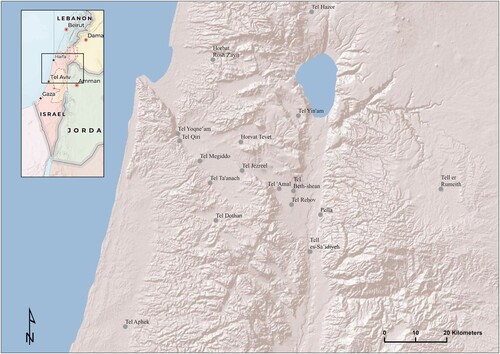
Figure 2. Topographical Map of Ḥorvat Tevet and its Excavations Areas.
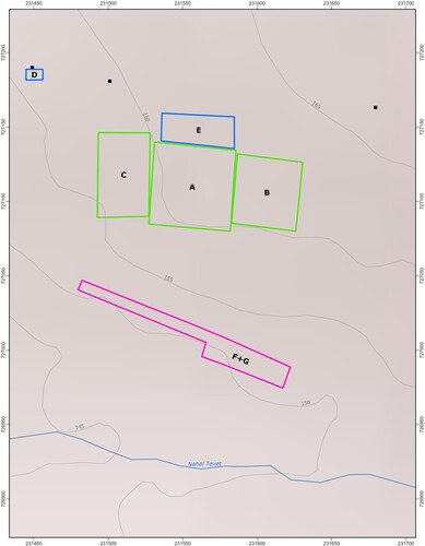
Table 1. Occupational Levels in Ḥorvat Tevet
For the majority of this time, Ḥorvat Tevet was the location of a rural community whose subsistence economy was based on the cultivation of the nearby fields. It was only in the late Iron IIA that the site acquired its public nature (Levels 7–4), marked by a series of destructions and reconstructions.
Sometime after the abandonment of the Iron I (Level 8) rural settlement in Ḥorvat Tevet (Amir et al. Citation2021, 2; Weitzel Citation2021, 164) a relatively large, pillared building (Building 7000) was erected on the summit of the site and attributed to Level 7 (). The remains of this building were met in two probes. Still, since the architectural remains in both probes are identical in building materials, construction technique, design and elevation, and both were sealed under the same destruction debris, they should be attributed to the same structure. Accordingly, Building 7000 was a large, monumental pillar building (measuring at least c. 20 m in length). Two stone installations meant for the extraction of liquids were also associated with this level. Level 7 came to an end with a heavy conflagration, but the site was quickly restored, and following a short transitional occupation (Level 6) a second pillared building (Building 5000) was erected on the summit of the site and is associated with Level 5 ().
Figure 3. Schematic Plan of the Sequence of Late Iron IIA Pillared Buildings in Ḥorvat Tevet, Area A.
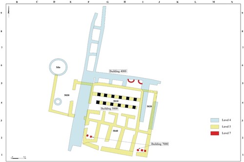
Building 5000 was relatively large (40 m long and 15 m wide) and consisted of three latitudinal halls. The central hall was then further divided into three longitudinal spaces by two parallel rows of monolithic stone pillars. All the walls were built of semi-hewn limestone blocks with a mudbrick superstructure, and the halls and surrounding courts were paved throughout. To the west of the pillared building, an area for craft specialisation, including a pottery kiln, was detected. On the lower terrace of the site, only one occupational level could be associated with the entire lifespan of Levels 7–5 (detected on the site's summit). It consisted of more than a dozen stone installations functioning to extract liquids that continued to be used as long as the summit of the site was adorned with Buildings 7000 and 5000. The end of this occupational level was marked by the destruction of pillared Building 5000 (Level 5) in a fierce conflagration, while the craft and production areas to its west and on the lower terrace were abandoned.
The pottery assemblage retrieved from Levels 7–5 at Ḥorvat Tevet is typical of the late Iron IIA (cf. Herzog and Singer-Avitz Citation2006; Arie Citation2013) and included Cylindrical Holemouth Jars (Butcher et al. Citation2022) red-slipped and hand-burnished ware, ridged necked and bulbous storage jars, better known as Hippo Jars (cf. Kleiman Citation2017), and some Cypriot Black-on-Red Ware (cf. Kleiman et al. Citation2019). This assemblage is well dated to the 9th century bce, as demonstrated by numerous radiocarbon results from nearby sites in the Jezreel and Beth-Shean Valleys (Lee, Bronk-Ramsey and Mazar Citation2013; Toffolo et al. Citation2014). A recent paleomagnetic study conducted by Vaknin et al. (Citationforthcoming) indicated that the destruction of Level 7 in Ḥorvat Tevet is contemporaneous with the destruction of Stratum V at Tel Reḥov. This destruction is dated to the late10th or early 9th centuries bce (c. 900 bce; cf. Mazar Citation2020, .2), whilst the destruction of Level 5 at Ḥorvat Tevet parallels that of Stratum IV at Tel Reḥov (c. 840–830 bce cf. Mazar Citation2020, 121). Levels 7–5 in Ḥorvat Tevet span, therefore, the late 10th to the last third of the 9th century bce.
Table 4. Distal Breadth of Cattle (Bos taurus) Metacarpals.
The size of both pillared buildings in Levels 7 and 5, the quality of their materials and construction technique, their visibility, and the fact that they overlay a former village all indicate that they represented some aspect of external centralised political power. The stratigraphical sequence of Ḥorvat Tevet—consisting of two successive occupational levels characterised by monumental building activity, followed by massive destruction and/or abandonment—is a feature of many late Iron IIA sites in the northern valleys (e.g., Tel Megiddo Q5–Q4, Tel Reḥov V–IV, Tel Hazor X–IX, Tel ʿAmal IV–III, Ḥorvat Rosh-Zayit IIb–IIa),Footnote2 as recently observed by Finkelstein and Kleiman (Citation2019). These sites are commonly identified with early monarchic Israel,Footnote3 and their contemporaneous destruction/abandonment in the second half of the 9th century bce is associated with the campaigns of Hazael of Damascus against Israel.Footnote4 Therefore, it can be assumed that throughout the period during which Ḥorvat Tevet was adorned with monumental pillared buildings on its summit (Levels 7–5), it signified the Israelite rule in the rural hinterland of the Jezreel Valley.
Evidence suggests that during this period Ḥorvat Tevet functioned as an administrative centre of a royal estate, responsible for the production, collection, and redistribution of agricultural output (Sergi et al. Citation2021). Storage jars make the most common type of vessel in Levels 7–5, comprising almost half of the assemblage. Concentrations of restorable storage jars were found in specific locations in and around Building 5000, which suggest that the building functioned as a storage facility. The overall storage capacity of the site, as demonstrated by the large assemblage of storage vessels, exceeds by far the storage needs of the local community. This means, that commodities stored in Ḥorvat Tevet were not meant for local consumption, but rather, they were further distributed to consumers in other locations.
Further insights into the redistributive mechanism operated from Ḥorvat Tevet may be gained from studying the storage vessels found at the site. Two types of very specific storage jars dominate the assemblage of Ḥorvat Tevet in Levels 7–5: Cylindrical Holemouth Jars (henceforth CHJ) and the so-called ‘Hippo Jars’, and both demonstrate characteristic of centralised production/use. About 260 CHJs were found in Ḥorvat Tevet, 215 of them were found in one room—the eastern entrance hall of Building 5000 (unit 5020). The distribution of the CHJs is restricted in time to the late Iron IIA and in space to the north of Israel, which already suggests that they had a specific use in a specific historical context. A recent study of their distribution, provenance, production, and use (Butcher et al. Citation2022) demonstrates that the CHJs were produced according to elite demand and were utilised as storage vessels involved in the provision of grain.
For the purpose of the current discussion, noteworthy is the fact that when uncovered in large numbers (>10), the CHJs were never found scattered across a site. Instead, they were clustered in central storage facilities that were mostly adjacent to palaces/monumental residencies. Thus for instance, at Tel Dothan c. 96 holemouth jars were all discovered in an ‘Administrative Building’ (Free Citation1958, 12); at Tel Megiddo, c. 88 holemouth jars were found in a storage room adjacent to Palace 1723 (Kleiman Citation2022:, 927, Table 23.30 25; Arie Citation2013, 715); at the royal compound in Tel Jezreel, c. 45 holemouth jars were found within the fortified gate complex (Ussishkin and Woodhead Citation1994, 12; 38 Zimhoni Citation1992, 64; Fig. 5, 8–12; 1997, Fig. 7, 1–8; Fig. 12, 6–7); at Tel Reḥov c. 40 CHJs were uncovered from buildings related to industry and storage (Mazar et al. Citation2005, 238; Panitz-Cohen Citation2020, 209–11); Lastly, and as demonstrated above, 215 CHJs were found in one room within the pillared Building 5000 in Ḥorvat Tevet.Footnote5
The fact that the CHJs are mostly found within central storage facilities suggests that they were utilized within an administrative/elite context. It is reasonable to assume that sites, in which large numbers of CHJs were found in one central storage facility, were all taking part within the same redistribution mechanism. The overall 260 CHJs found in Ḥorvat Tevet, far more than in any other contemporaneous site, indicate that Ḥorvat Tevet had a central role in the redistributive mechanism that utilised these specific jars. Accordingly, it may be suggested that provisions from Ḥorvat Tevet were sent to the main urban and royal centres in late Iron IIA Jezreel, Dothan, and Beth-Shean Valleys, among those were: Tel Reḥov, Tel Dothan, Tel Megiddo, and Tel Jezreel. The latter two are directly identified with the rule of the Omride dynasty (Finkelstein Citation2000; Sergi and Gadot Citation2017).
The many stone installations meant for extracting fluids detected on the Lower Terrace of the site suggest another pattern of large-scale production. The study of charred wood remains from Levels 7–5, indicated that 85% of the wood originated in local olive trees.Footnote6 This may suggest that the stone installations were meant for the production of olive oil, however, other possibilities, like the production of beer,Footnote7 are also considered. In any case, the raw material needed for the production of beer (grains) or for the production of oil (olives) was grown in the vicinity of the site. What exactly was produced by the installations in the Lower Terrace requires further research, but regardless of the exact purpose of these installations, they imply large scale production of some kind of a liquid commodity, made of raw materials brought from nearby. Doubtless production in the many stone installations exceeds the local needs and was meant to be exported.
It seems, therefore, that during the late Iron IIA Ḥorvat Tevet (Levels 7–5) functioned as a central storage facility, where agricultural commodities were collected, processed, and stored before they were further redistributed—probably to sites in the nearby Jezreel and Beth-Shean Valleys. This is beyond doubt a mechanism of the royal, redistributive economy (cf. Master Citation2014; Schloen Citation2016), and therefore we argue that Ḥorvat Tevet Levels 7–5 was the administrative centre of a royal estate. By royal estate, we refer to large plots of land belonging to a political institution and administrated by a bureaucratic centre, as opposed to lands given to farmers as tenants to be cultivated in return for a share of the crops (Finkelstein and Gadot Citation2015, 230). In light of the fact that agricultural commodities produced and stored in Ḥorvat Tevet were distributed to sites identified with royal (Tel Jezreel, Tel Megiddo) and urban (Tel Rehov, Tel Dothan) centres affiliated with early monarchic Israel, it may be concluded that Ḥorvat Tevet was the administrative centre of an Israelite royal estate.
In this regard, one more point should be made: to date, there is no archaeological evidence to support the existence of a local organic, rural community living in late Iron IIA Ḥorvat Tevet. There are hardly any domestic structures at the site, the assemblage of imported ware is remarkably small, and most significantly, the burial tradition at the site came to an end with the erection of the pillared building on its summit (Weitzel Citation2021). Ḥorvat Tevet Levels 7–5 was not a locale where people were born and raised, practised their daily livelihood, owned property, or died and were buried. Late Iron IIA Ḥorvat Tevet was a place where people worked and performed various activities—from field cultivation to herding, from pottery production to managing a redistributive apparatus—but none of these were performed on a domestic level. This means that the people who performed these activities were not local to the site. The labour force responsible for the various activities performed in the royal estate administered from Ḥorvat Tevet was probably recruited from the nearby villages and towns. The practice of corvée labour was well known in the southern Levant, and it already operated in the same region (the rural hinterland on the north-east margins of the Jezreel Valley) by the Egyptian royal economy during the Late Bronze II–III.Footnote8 The very fact that already during the Late Bronze II–III the lands in the north-eastern margins of the Jezreel Valley served a royal estate, that was operated by corvée labour, provides further support for the identification of late Iron IIA Ḥorvat Tevet as an Israelite royal estate based on the same lands.
Methods
Faunal remains for this study were sorted into ‘Upper Terrace’ and ‘Lower Terrace’ assemblages with the Upper Terrace representing Level 7–5 of Areas A, B, and C, and the Lower Terrace representing Phases F1, G1–2 of Areas F and G. Identification of skeletal elements and species was based on the vertebrate collections stored at the Steinhardt Museum of Natural History and the Zooarchaeology Laboratory, Tel Aviv University. Faunal remains were recorded and analysed using the same protocol, following Sapir-Hen, Gadot, and Finkelstein (Citation2016) and included identification of all skeletal elements. Statistical analysis was processed using PAST 3.26 (Hammer, Harper, and Ryan Citation2001).
The relative abundance of different taxa was quantified using NISP (Number of Identified Specimens) (Grayson Citation1984; Lyman Citation2008). The separation of sheep (Ovis aries) from goats (Capra hircus) was based on morphological criteria of selected bones (following Zeder and Lapham Citation2010). Bones that could only be identified to species were assigned to a body size group, either large mammal (cattle/donkey size) or medium mammal (sheep/goat). Since most large mammals identified in all assemblages were cattle, it can be assumed that the ‘large mammal’ body size group includes mainly cattle. All fully fused epiphyses were measured, following the guidelines of von den Dreisch (1976).
The relative abundance of skeletal elements was quantified using MAU (minimum animal units), calculated by using MNE (minimum number of elements; Klein and Cruz-Uribe Citation1983 and Lyman Citation1994, Citation2008), while taking into consideration the element side and fusion stage. MNI’s values are based on MNE and calculated per locus. To examine if select body portions were consumed for their caloric intake or utility, MNE’s were compared to the food utility index (FUI) of Metcalfe and Jones (Citation1988) and to Binford’s marrow index (1981, 28). Age at death of culled species was analysed to study the exploitation aim of the primary livestock, based on epiphyseal closure (Silver Citation1969 for cattle; Zeder Citation2006 for caprines). Age at death of caprines was also analyzed based on tooth wear, following Payne (Citation1973). The estimation of the sex of caprines was based on measuring the distal depth of the humerus (Dd) compared to goats with known sex as recorded by Zeder (Citation2001, 64, 66). The metrical cut-off point for the distinction between male and female goats is 29 mm, therefore, we can predict that a specimen smaller than 29 mm is a female and those larger are males (following, Zeder Citation2006, Table 1). Sexing of cattle was based on the distal breadth of metacarpals, with 63 mm representing the distinction between male and females (following Davis et al. Citation2012).
Results
The assemblage from the Upper Terrace included a total of 955 faunal remains (NISP) identified by species. The assemblage from the Lower Terrace included a total of 483 faunal remains (NISP) identified by species (). Livestock (i.e., sheep, goats, and cattle) are the most prevalent species at Ḥorvat Tevet in the Upper and Lower Terraces (). They represent over ninety percent of their respective assemblages. Cattle constitutes 43.6% of the Upper Terrace and 53% of the Lower Terraces. The Lower Terrace has a significantly higher frequency of cattle than the Upper Terrace (X2 = 16.2, df = 1, Cramer’s V = 0.153, p < 0.005). Caprines, a combined category of sheep and goats, represent 49.8% of the Upper Terrace and 42% of the Lower Terrace, with no significant difference between their frequencies (X2 = 1.44, df = 2, Cramer’s V = 0.046, p = 0.48). The ratios of distinguishable sheep and goats are relatively equal in the Upper and Lower Terraces, with slightly more sheep in the Upper Terraces with a ratio of 14:13 and slightly more goats in the Lower Terrace with a ratio of 3:4 ().
Table 2. Number of Identified Specimens (NISP), Minimum Number of Individuals (MNI), And Frequency of Species (NISP%) of the Upper and Lower Terraces.
Other common species at Ḥorvat Tevet include a variety of game animals such as mountain gazelle (Gazella gazella), roe deer (Capreolus capreolus), red deer (Cervus elaphus), fallow deer (Dama mesopotamica), cape hare (Lepus capensis), and wild boar (Sus scrofa) representing 3.4% of the Upper Terrace and 2.4% of the Lower Terrace (). Birds, rodents, and fish are present only in the Upper Terrace. These rarer species include chukar partridge (Alectoris chukar), geese (Anser anser), and Mediterranean fish such as dentex (Dentex dentex) and seabream (Sparidae).
Cattle Exploitation
Age estimation of cattle from Ḥorvat Tevet was based on the stage of epiphyseal fusion and tooth wear. Cattle survivorship (% fused bones) of the Upper Terraces indicate that 74% of cattle survived to three years of age (). Of the cattle 40% survived past three-and-a-half years, and 60% survived past four years (). This mortality profile suggests that the exploitation strategy of cattle in the Upper Terrace focused on agricultural labour and meat consumption. Tooth-wear for the Upper Terrace cattle indicates some cattle were culled at a younger age, and some survived to an older age (). In the Lower Terrace, cattle survivorship demonstrates that most cattle survived past one-and-a-half years (95%), with roughly 20% culled between two to three years and 44% surviving past three-and-a-half years (). It should be noted that there was no evidence for cattle over four years of age in the Lower Terrace; however, it is unclear if this relates to subsistence or assemblage size bias. Therefore, the mortality profile of cattle from the Lower Terrace points to a dualistic economic focus on agriculture labour and meat. Comparing the mortality profiles of cattle between the Upper and Lower Terraces indicates a relatively similar survivorship in both Terraces, with the Upper Terrace having access to slightly younger cattle than the Lower Terrace.
Figure 4. Histogram of the Percentage of Fused Elements for Cattle in Upper and the Lower Terraces. Age estimation following Silver (Citation1969).
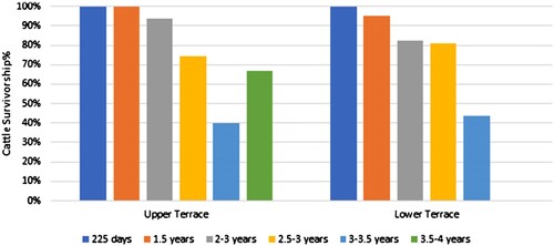
Table 3. Tooth-wear of Caprine and Cattle for the Upper and Lower Terraces following Grant (1982) and Payne (Citation1973).
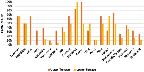
The most frequent cattle body parts in Upper Terrace include the upper forelimbs, humerus and scapula, and lower limbs, such as the radius, tibia, and metapodial (). In the Lower Terrace, cattle body parts’ frequencies denote a similar pattern. The most common cattle element is the humerus, radius, and scapula, followed by the hindlimb’s metapodials, tibia, and femur (). Differences between the exploitation of cattle body parts in the Upper and Lower Terrace include slightly more truncal vertebrae and ribs in the Upper Terrace and slightly more femoral fragments in the Lower Terrace. These portions are both considered rich in meat. Thus, we can propose that the Lower Terrace focused on consuming specific portions like the fore- and hindlimbs, compared to the Upper Terrace, which consumed the entire cattle and focused on the forelimb.
Figure 5. Body Part Comparison of Cattle from the Upper and Lower Terrace, based on Minimal Animal Units %.
The estimation of the sex of the cattle based on the distal breadth of metacarpals indicates that there are two female cows and one male cow in the Upper Terrace. In the Lower Terrace, two specimens with a distal breadth smaller than 63 mm; therefore, both are likely females (). Overall, the sex estimation of cattle should be treated with caution as it is based on modest sample sizes.
Caprines Exploitation
The aging of the caprine assemblages from the Upper and Lower Terraces was based on epiphyseal fusion and tooth wear. Upper Terrace caprine survivorship (% fused bones) shows that 73% of the herd survived past one year, and 48% survived past four years (), denoting a focus on both meat and secondary products (following the models of Payne [Citation1973]). The survivorship percentage of caprines in the Lower Terrace indicates the culling of caprines under one year of age, with 89% surviving. Caprines were continually culled as juveniles, with 60% surviving past one-and-a-half years and 71% surviving past three years (). The caprine survivorship % of the Lower Terrace also indicates 100% survival over four years (), suggesting a dynamic exploitation pattern focused on exploiting caprines for milk and wool. The tooth-wear of caprines corroborates the mortality profile based on epiphyseal fusion ().
Figure 6. Histogram of the Percentage of Fused Elements for Caprines in Upper and Lower Terrace. Age estimation following Zeder (Citation2006).
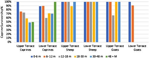
Exploring the different culling patterns of sheep and goats independently indicates that goats were killed off between 12–18 months in the Upper Terrace, whereas sheep were killed off at 18–30 months (). Comparatively, sheep were maintained past four years of age. There is no indication that goats survived over one year in the Lower Terrace.
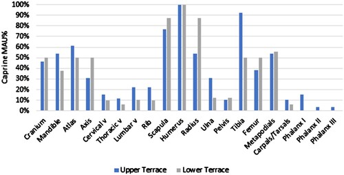
The exploitation of caprine body parts is similar between the Upper and Lower Terraces. The most common caprine elements are the upper forelimb elements, scapula, and humerus, and to a lesser extent, the lower limb elements, radius, and metapodials (). The only difference between the body part exploitation of caprines in the Upper and Lower Terraces is the higher frequency of tibia in the Upper Terrace. The frequency of tibia and metapodials likely reflects refuse created during the preparation of meals as these elements do not contain high yields of meat. However, another possible rationalisation for the frequency of tibia and metapodials is the exploitation of marrow because these portions are high in caloric value (Binford Citation1981, 28; Metcalfe and Jones Citation1988; Morin 2007). Breakage patterns of metapodials and tibia suggest these elements were highly fractured with a completeness percentage of 36–37% (calculated as [(NISP/MNE)*100)]. However, there is no significant difference between the MNE of the Upper Terrace compared to the Marrow Index of Binford (Citation1981, 28; p = 0.61, r = 0.04) or to the FUI of Metcalfe and Jones (Citation1988; p = 0.250, r = 0.3320), limiting our understanding if the food utility of elements may have played a role in the selection of body parts that were exploited in the Upper Terrace.
Figure 7. Body Part Comparison of Caprines from the Upper and Lower Terrace, based on Minimal Animal Units %.
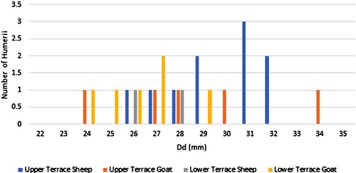
The sexing of caprines was based on humerii distal depth (Dd) measurements compared to known sexual dimorphic measurements of caprines following Zeder (Citation2001). The ratio between male and female goats in the Upper Terrace is 2:3 and in the Lower Terrace is 1:5 (). Zeder (Citation2006) only presents metrical data for goats. However, this data can be used as a hypothetical model for sexing sheep based on the same measurement parameters because they are of similar size and morphology. The ratio between male and female sheep in the Upper Terrace is 7:2. In the Lower Terrace, there are two sheep specimens smaller than 28 mm and no specimens greater than 29 mm, suggesting only females were measured. Mixture analysis of the humerii distal depth (Dd) of sheep from both the Upper and Lower Terraces also supports the suggestion that the site prefers male sheep, but females were also present (female: prob = 0.42, mean = 31.79, StDev = 0.51; male: prob = 0.57 mean = 28.18, StDev = 1.26). The sample size for metrical analysis is modest, and these results should be considered conjecture.
Figure 8. Distal Depth (Dd) Measurement (mm) of Sheep and Goat Humerii.
Discussion
Ḥorvat Tevet was the administrative centre of an Israelite royal estate, a place where agricultural commodities were collected and stored before they were further redistributed to royal and urban centres in the adjacent valleys. It is within this archaeological and historical context that we examine the faunal assemblage from the site.
The frequency of cattle at Ḥorvat Tevet is very high in the Upper and Lower Terraces (43–53%). These frequencies are higher than the frequency of cattle in contemporary Iron IIA sites: 20% cattle at Tel Reḥov (Marom et al. Citation2009; Tamar, Marom, and Raban-Gerstel Citation2020, Table 49.6), 24% cattle at Rosh Zayit (Str. III; Horwitz Citation2000), ∼20% of cattle at Megiddo (Sasson Citation2013, Fig. 27.4) and Hazor (Lev-Tov Citation2012). Most of the aforementioned sites are urban/royal sites, besides Rosh Zayit, which is a storage facility fort in Northern Israel (Gal and Alexandre Citation2000). The only site showing a high frequency of cattle in the greater region, but still lower than Ḥorvat Tevet, is the fortified site of Tel Yoqneʿam, with 36–38% cattle (Str. XVI–XV; Horwitz et al. Citation2005).
According to Sasson (Citation2005), the northern valleys have the highest carrying capacity for cattle in the Southern Levant. Carrying capacity is defined as the availability of foraging fodder per dunam (i.e., feed units; Sasson Citation2005). In more simplistic terms, the northern valleys were the optimum area for cattle herds. Yet, cattle frequencies at almost all of the sites in the northern valleys, and especially in Tel Megiddo and Tel Reḥov, the most prominent urban centres in the Jezreel and the Beth-Shean Valleys (respectively), are just slightly higher than the proposed agricultural labour threshold of 15% (Sasson Citation2005), and still less than half of the cattle frequency in Ḥorvat Tevet. Thus, and while communities in Tel Megiddo and Tel Reḥov were probably engaged in small-scale grain cultivation, some sectors at these sites could still be provided by grain from Ḥorvat Tevet. At any rate, the exceptionally high frequencies of cattle attests that during the late Iron IIA, Ḥorvat Tevet was responsible for wide-ranging field cultivation, growing and storing grains/cereals on a large scale, which could potentially provide for many of the contemporaneous late Iron IIA sites in the nearby Jezreel, Dothan and Beth-Shean Valleys.
This is not to suggest that grain from Ḥorvat Tevet was meant to feed the entire population of the valley sites. Communities in these sites still practiced field cultivation, but on a relatively smaller scale, especially when compared to Ḥorvat Tevet. We suggest, therefore, that grain produced and stored in Ḥorvat Tevet was provided to certain sectors in these sites, and probably in order to fulfil some specific purposes (payment for workers or feeding army units, etc.). This conclusion is supported by the study of CHJs, according to which these jars were used within the system of grain distribution, operated from Ḥorvat Tevet (Butcher et al. Citation2022). In this regard, it is worth noting that only two CHJs were found in late Iron IIA Tel Yoqneʿam, which is the only site in the northern valleys with evidence for large-scale field cultivation (c. 36–38% cattle frequency). While the small number of CHJs found in Tel Yoqneʿam may be the result of its small-scale excavations, they may also attest that site with large ploughing communities were not provided by the royal economic mechanism related to Ḥorvat Tevet. This was not the case of Tel Megiddo and Tel Reḥov, with their relatively small ploughing communities.
The regional role of late Iron IIA Ḥorvat Tevet as producer can also be observed by caprine exploitation. At Ḥorvat Tevet, goats were culled earlier than sheep, and this is probably due, in part, to pastoralists killing off younger goats to preserve the doe's milk for dairy production. Instead, they herded sheep longer to exploit their wool (Payne Citation1973; Vigne and Helmer Citation2007). This means that Ḥorvat Tevet was a major producer of dairy products, wool, and meat, which stands in a marked contrast to the more consumer patterns detected in the nearby urban/royal centres, Tel Reḥov V–IV and Tel Megiddo VA–IVB.
Marom et al. (Citation2009) note that the animal economy of Tel Reḥov was of higher status consumers. They propose that the site was provided with livestock from nomads or neighbouring villages engaged in a limited form of seasonal transhumance. This assessment is based on the prevalence of high-quality portions of young male caprines in the domestic contexts of Tel Reḥov. The animal economy of palatial Tel Megiddo in the late Iron IIA indicates a continuity of consumer consumption habits but not of agricultural production (Sasson Citation2013, Fig.27.5, Fig. 27.7, Fig. 27.8; Sapir-Hen et al. Citation2016). In Tel Megiddo, culling of sub-adult and juvenile caprines in the late Iron IIA is at its zenith compared to the caprine mortality profiles in the Iron I, early Iron IIA, and Iron IIB. It seems, therefore, that the agricultural production sector of Ḥorvat Tevet is the only site in the Jezreel and Beth-Shean Valleys during the late Iron IIA with evidence of pastoral producer strategies. In other words, Ḥorvat Tevet was the primary producer in the Jezreel and Beth-Shean Valleys during the late Iron IIA, focusing on meat, wool, and dairy products. In light of the data, it is reasonable to assume that these products were sent to the nearby sites, and particularly Tel Megiddo VA–IVB, and Tel Reḥov V–IV.
This observed pattern is coherent with the pattern of cattle exploitation at the site, and together they demonstrate that Ḥorvat Tevet functioned as a major producer of grain, meat, dairy products, and wool. While grains were most probably grown in the rich fields of the north-eastern Jezreel Valley, herding could take place on the slopes of the nearby Ha-Moreh Hill, and in the vast grazing land of the Issacharite Plateau to the east. Both field cultivation and herding were under the direct responsibility of the authorities at Ḥorvat Tevet. In any case, the study of faunal remains attests beyond doubt that Ḥorvat Tevet was not only a place where agricultural commodities were collected and stored prior to their redistribution, but it was also responsible for the production of these commodities.
On a local level, the animal economy of ancient settlements also allows us to identify differential access to meat. Differences in animal usage and economy may reflect patterns of social disparity in ancient assemblages (e.g., Curet and Pestle Citation2010; Trusler Citation2017). Sheep and goats at Ḥorvat Tevet in the Iron IIA were exploited for primary and secondary products. In the Upper Terrace there is evidence that caprines were kept for both primary and secondary products but in the Lower Terrace, they were kept to an older age, indicating their main use was for secondary products.
Our results indicate that the Upper Terrace economy is representative of a higher-status population. The Upper Terrace preferred younger male sheep, similarly to the Iron I–IIA neighbourhoods of Tel Reḥov (Marom et al. Citation2009, ; ; Tamar, Marom, and Raban-Gerstel Citation2020, 502–04) and in Iron Age IIA Tel Megiddo (Levels H8-H5, K3-K2, L3, Sasson Citation2013, Fig. 27.5; Fig. 27.7; H-9, Sapir-Hen et al. Citation2016). In contrast, the caprine exploitation in the Lower Terrace focused on female caprines that survived beyond four years of life for wool and dairy production. Patterns of dairy production from goats and wool production from sheep are exaggerated in the Lower Terrace, indicating that this area predominantly focused on retaining caprines for secondary products and culling them at an older age for meat consumption.
The preference for older female caprines in the Lower Terrace bolsters our conclusion that the economic focus of this terrace was on agropastoral products. Based on our results, the Lower Terrace was of lower economic status because it subsisted on the caprines that were not consumed in the Upper Terrace or redistributed to neighbouring sites. The Upper and Lower Terraces had access to rich-meat portions of sheep, goats, and cattle. The Upper Terrace assemblage, however, has more evidence for on-site butchery than the Lower Terrace, which has evidence of select portions of livestock. Therefore, we can posit a reality where livestock was butchered near the large, pillared building (Building 5000). The Upper Terrace retained meat from younger livestock and select portions of lower quality livestock were distributed amongst the corvée labour working in the production sector of the Lower Terrace. Craft and agricultural production in the Lower Terrace is also indicated by the many stone installations for the extraction of fluids, which required hard labour. Overall, this reinforces our understanding that the administrative structure on the Upper Terrace had control over butchering and meat allocation, a pattern that is similar to the distribution of CHJs at the site.
From this vantage point, the status of Ḥorvat Tevet as a producer is nuanced with the management and storage occurring in the Upper Terrace and actual production and agricultural labour occurring in the Lower Terrace. Furthermore, this study reveals another important aspect of the Israelite royal economy in the late Iron IIA. It seems that the labour force working and producing at the site, which was most probably recruited from the nearby villages and towns, were well fed, with provisions (meat and probably also grain or flour) from the local herds and the local royal lands.
Conclusions
Late Iron IIA Ḥorvat Tevet, operated by an amalgamation of elites and corvée labour, who were involved in the agricultural production of grain and animal by-products unprecedented in contemporary sites of the Northern Valleys of Israel. In fact, the analysis of faunal remains presented in this article demonstrates that Ḥorvat Tevet was a major producer, far beyond local needs, while sites in the nearby Jezreel and Beth-Shean Valleys, particularly Tel Reḥov and Tel Megiddo, reveals animal economy with only small-scale local production sector. This in turn, and in light of other finds from the site, suggests that agricultural products from Ḥorvat Tevet were exported to urban (Tel Reḥov) and royal (Tel Megiddo, Tel Jezreel) sites of early monarchic Israel. Accordingly, the identification of Ḥorvat Tevet as the administrative centre of an Israelite royal estate, is only reinforced in light of the analysis of faunal remains. Moreover, this analysis demonstrated that Ḥorvat Tevet was not only a locale where agricultural commodities were collected prior to their redistribution, but it was likewise responsible for the large-scale production of these commodities in the nearby valley lands and grazing areas.
This reveals a level of economic centralization in the hands of Israelite elites, exercised through a sophisticated mechanism of redistributive economy. It should be noted that it was not meant to feed the entire population of specific urban or royal sites or, for that matter, an entire territorial kingdom. The production and storage of agricultural products at Ḥorvat Tevet were based on royal property and centralized administrative apparatus. Thus, it most probably served royal/administrative needs, like payment for an army, officials, or other local clients and elites. Indeed, the distribution of faunal assemblage in Ḥorvat Tevet indicates that the labouring sector of the site, located mainly on the site’s Lower Terrace, was fed by provisions that were distributed from the Upper Terrace, where the local elites, who administered the various activities performed at the site and its immediate surroundings, resided. The labouring sector identified in the Lower Terrace was based on a workforce recruited from the nearby villages and towns for a limited period of time by means of ‘labour tax’ or ‘corvée labour’. As such, it seems that the labourers recruited for the hard work in the fields and production sites were well fed by the same royal economic mechanism and on the expanse of the royal lands and herds.
Acknowledgements
This study is the outcome of a research project titled, ‘The Archaeological Expression of Palace–Clan Relations in the Iron Age Levant: A Case Study from the Jezreel Valley, Israel’, funded by the Gerda Henkel Stiftung (AZ 20/F/19) and directed by Omer Sergi, Hannes Bezzel and Karen Covello-Paran.
Disclosure statement
No potential conflict of interest was reported by the authors.
Additional information
Funding
Notes
1 Trial excavations carried out on behalf of the Israel Antiquities Authority were directed by Karen Covello-Paran (2012) on the Upper Terrace of the site, and by Yoav Tsur (2019) on the Lower Terrace of the site. Salvage excavations on the Upper Terrace and beyond were carried out by the Israeli Institute of Archaeology, on behalf of the Sonia and Marco Nadler Institute of Archaeology in Tel Aviv University, directed by Omer Sergi (Citation2018), and Omer Sergi and Rachel Lindeman (2019).
2 Tel Hazor X was dated by the excavators of the site to the mid-tenth century bce (Ben-Tor and Ben-Ami Citation1998; Ben-Tor Citation2000). However, the assemblage associated with this level should be attributed to the late Iron IIA (Herzog and Singer-Avitz Citation2006; Sergi and Kleiman Citation2018, footnote 9), which is well dated, according to radiocarbon, to the late tenth–ninth century bce.
3 E.g., Herzog and Singer-Avitz Citation2006; Niemann Citation2006; Finkelstein Citation2013, 66; Sergi and Gadot Citation2017; Sergi Citation2019; Mazar Citation2020, 124.
4 Finkelstein and Piasetzky Citation2007; Mazar Citation2016; Kleiman Citation2016; Shochat and Gilboa Citation2018.
5 For further details and discussion, see: Butcher et. al. 2022.
6 The study of charred wood remains was conducted by Diana Martinez in the Laboratory of Archaeobotany and Ancient Environment headed by Dafna Langgut in Tel Aviv University. The results of this study are currently prepared for publication.
7 David Eitam, personal communication.
8 Na’aman Citation1988; Morris Citation2005, 231–32; Finkelstein et al. Citation2017, and cf. EA 250 and 365.
References
- Arie, E. 2013. ‘The Late Bronze III, Late Iron I and Iron IIA Pottery Levels K-6, M-6, M-5, M-4 and H-9’, in I. Finkelstein, D. Ussishkin, and E. H. Cline, E (eds), Megiddo V: The 2004–2008 Season, Tel Aviv: Monograph Series of the Sonia and Marco Nadler Institute of Archaeology 31, 475–667.
- Amir, A., et al., 2021. ‘Heated Beeswax Usage in Mortuary Practices: The Case of Ḥorvat Tevet (Jezreel Valley, Israel) ca. 1000 bce’, JAS: Reports 36, 102904.
- Ben-Tor, A., 2000. ‘Hazor and the Chronology of Northern Israel: A Reply to Israel Finkelstein’, BASOR 317, 9–15.
- Ben-Tor, A., and Ben-Ami, D., 1998. ‘Hazor and the Archaeology of the Tenth Century bce’, IEJ 48, 1–37.
- Binford, L. R., 1981. Bones, Ancient Men and Modern Myths, New York: Academic Press.
- Butcher, M., et al., 2022. ‘The Late Iron IIA Cylindrical Holemouth Jars and Their Role in the Royal Economy of Early Monarchic Israel’, Tel Aviv 49, 1–38.
- Conder, C. R., and Kitchener, E. H. H., 1881. The Survey of Western Palestine: Arabic and English Name Lists, London: Committee of the Palestine Exploration Fund.
- Crabtree, P. J., 1990. ‘Zooarchaeology And Complex Societies: Some Uses of Faunal Analysis for The Study of Trade, Social Status, And Ethnicity’. Archaeological Method and Theory 2, 155–205.
- Curet, A. L., and Pestle, W. J., 2010. ‘Identifying High-Status Foods in The Archaeological Record’, Journal of Anthropological Archaeology 29.4, 413–31.
- Davis, S. J. M., et al., 2012. ‘Molecular and Osteometric Sexing of Cattle Metacarpals: A Case Study from 15th century ad Beja, Portugal’, JAS 39.5, 1445–454.
- DeFrance, S. D., 2009. ‘Zooarchaeology In Complex Societies: Political Economy, Status, And Ideology’, JAR 17, 105–68.
- Driesch von den, A., 1976. A Guide to the Measurement of Animal Bones from Archaeological Sites (unpublished MA Thesis), Harvard University, Cambridge, MA, USA.
- Finkelstein, I., 2000. ‘Omride Architecture’, ZDPV 116, 114–38.
- Finkelstein, I., 2013. ‘The Forgotten Kingdom: The Archaeology and History of Northern Israel’, Ancient Near Eastern Monograph 5, Atlanta: Society of Biblical Literature.
- Finkelstein, I., and Gadot, Y., 2015. ‘Mozah, Nephtoah and Royal Estates in the Jerusalem Highlands’, Semitica et Classica 8, 227–34.
- Finkelstein, I., et al., 2006. ‘The Megiddo Hinterland Project’, in I. Finkelstein, D. Ussishkin, and B. Halpern (eds), Megiddo IV: The 1998–2002 Seasons, Tel Aviv: Monograph Series of the Institute of Archaeology of Tel Aviv University 24, 705–76.
- Finkelstein, I., and Kleiman, A., 2019. ‘The Archaeology of the Days of Baasha?’, RB 126, 277–96.
- Finkelstein, I., et al., 2017. ‘Egyptian Imperial Economy in Canaan: Reaction to the Climate Crisis at the End of the Late Bronze Age’, Ägypten und Levante 27, 249–60.
- Finkelstein, I., and Piasetzky, E., 2007. ‘Radiocarbon, Iron IIA destructions and the Israel–Aram Damascus Conflicts in the 9th century bce’, UF 39, 261–76.
- Free, J. P., 1958. ‘The Fifth Season at Dothan’, BASOR 152, 10–18.
- Gal, Z., and Alexandre, Y., 2000. ‘Ḥorbat Rosh-Zayit: An Iron Age Storage Fort and Village’, IAA Reports 8, Jerusalem: Israel Antiquity Authority.
- Grayson, D. K., 1984. Quantitative Zooarchaeology: Topics in the Analysis of Archaeological Faunas, New York: Academic Press.
- Halstead, P., and Isaakidou, V., 2011. ‘Revolutionary Secondary Products: The Development and Significance of Milking, Animal-Traction and Wool-Gathering in Later Prehistoric Europe and the Near East’, in T. Wilkinson, S. Sherratt, and J. Bennet (eds) Interweaving Worlds: Systemic Interactions in Eurasia 7th to 1st Millennia bc, Oxbow Books: Oxford, 61–76.
- Hammer, Ø., Harper, D., and Ryan P., 2001. ‘PAST: Paleontological Statistics Software Package for Education and Data Analysis’, Palaeontologial Electronica 4.1, article 4; http://palaeoelectronica.org/2001_1/past/issue1_01.htm.
- Herzog, Z., and Singer-Avitz, L., 2006. ‘Sub-Dividing the Iron Age IIA in Northern Israel: A Suggested Solution to the Chronological Debate’, Tel Aviv 33, 163–95.
- Horwitz, L. K., 2000. ‘Animal Exploitation—Archaeozoological Analysis’, in G. Zvi and Y. Alexandre (eds), Ḥorbat Rosh Zayit: An Iron Age Storage Fort and Village, Jerusalem: Israel Antiquities Authority Reports 8, 221–23.
- Horwitz, L. K., et al., 2005. ‘Faunal And Malacological Remains From The Middle Bronze, Late Bronze And Iron Age Levels at Tel YoqneʿAm’, in A. Ben-Tor, D. Ben-Ami, and A. Livneh (eds), Yoqne‘am III: The Middle and Late Bronze Ages: Final Report of the Archaeological Excavations (1977–1988), Jerusalem: Institute of Archaeology, Hebrew University of Jerusalem, 395–436.
- Kleiman, A., 2016. ‘The Damascene Subjugation of the Southern Levant as a Gradual Process (ca. 842–800 B.C.E.)’, in O. Sergi, M. Oeming, and I. de-Hulster (eds), In Search of Aram and Israel: Politics, Culture and Identity, Oriental Religions in Antiquity 20. Tübingen: Mohr Siebeck, 89–119.
- Kleiman, A., 2017. ‘A North Israelite Royal Administrative System and its Impact on Late-Monarchic Judah’, HeBAI, 6, 354–71.
- Kleiman, A., 2022. ‘The Iron II Pottery from Area Q’, in I. Finkelstein and M. A. S. Martin (eds), Megiddo VI: The 2010–2014 Seasons, Tel Aviv: Monograph Series of the Institute of Archaeology of Tel Aviv University 41, 894–1054.
- Kleiman, A., et al., 2019. ‘The Date and Origin of Black-on-Red Ware: The View from Megiddo’, AJA 123, 531–55.
- Klein, R. G., and Cruz-Uribe, K., 1983. ‘The Computation of Ungulate Age (Mortality) Profiles from Dental Crown Heights’, Paleobiology 9.1, 70–78.
- Lee, S., Bronk-Ramsey, C., and Mazar, A., 2013. ‘Iron Age Chronology in Israel. Results from Modeling with a Trapezoidal Bayesian Framework’, Radiocarbon 55, 731–40.
- Lev-Tov, J. S. E., 2012. ‘Archaeozoological Analysis of Animal Bones from Areas A2 And A4’, in A. Ben-Tor, D. Ben-Ami, and D. Sandhaus (eds), Hazor VI: The 1990–2009 Excavations, The Iron Age, Jerusalem: Israel Exploration Society and Hebrew University of Jerusalem, 586–603.
- Lyman, R. L., 1994. Vertebrate Taphonomy, Cambridge: Cambridge University Press.
- Lyman, R. L., 2008. Quantitative Paleozoology. Cambridge: Cambridge University Press.
- Marom, N., et al., 2009. ‘Backbone of Society: Evidence for Social and Economic Status of The Iron Age Population of Tel Rehov, Beth Shean Valley, Israel’, BASOR 354, 1–21.
- Marom, N., and Zuckerman, S., 2012. ‘The Zooarchaeology of Exclusion and Expropriation: Looking up from the Lower City in Late Bronze Age Hazor’, JAA 31.4, 573–85.
- Master, D., 2014. ‘Economy and Exchange in the Iron Age Kingdoms of the Southern Levant’, BASOR 372, 81–97.
- Mazar, A., 2016. ‘Discoveries from Tel Reḥov, the Early Days of the Israelite Monarchy’, in I. Ziffer (ed.), It Is the Land of Honey, Tel Aviv: MUZA Eretz Israel Museum, 9–67.
- Mazar, A., 2020. ‘Chapter 4: The Tel Reḥov Excavations, Overview and Synthesis’, in A. Mazar and N. Panitz-Cohen (eds), Tel Reḥov A Bronze Age City in the Beth-Shean Valley, Vol. 1, Introductions, Synthesis and Excavations on the Upper Mound, Jerusalem: Qedem 59, 69–140.
- Mazar, A., et al., 2005. ‘Ladder of Time at Tel Reḥov: Stratigraphy, Archaeological Context, Pottery and Radiocarbon Dates’, in T. E. Levy and T. Higham (eds), The Bible and Radiocarbon Dating: Archaeology, Text and Science, London: Routledge, 193–256.
- Metcalfe, D., and Jones. K. T., 1988. ‘A Reconsideration of Animal Body-Part Utility Indices’, American Antiquity 53.3, 486–504.
- Morris, E. F., 2005. The Architecture of Imperialism: Military Bases and the Evolution of Foreign Policy in Egypt's New Kingdom, Probleme der Ägyptologie 22, Leiden: Brill.
- Na'aman, N., 1988. ‘Pharaonic Lands in the Jezreel Valley in the Late Bronze Age’, in M. Heltzer, and E. Lipiński (eds), Society and Economy in the Eastern Mediterranean (c. 1500–1000 B.C.), Leuven: Orientalia Lovaniensia Analecta 23, 177–85.
- Niemann, H. M., 2006. ‘Core Israel in the Highlands and its Periphery: Megiddo, the Jezreel Valley, and the Galilee in the 11th–8th century B.C.E’, in I. Finkelstein, D. Ussishkin and B. Halpern (eds), Megiddo IV: The 1998–2002 Seasons, Tel Aviv: Tel Aviv, Monograph Series of The Institute of Archaeology of Tel Aviv University 24, 82–142.
- Panitz-Cohen, N., 2020. ‘Iron IIA Local Pottery’, in A. Mazar and N. Panitz-Cohen (eds), Tel Reḥov: A Bronze and Iron Age City in the Beth-Shean Valley, Volume IV: Pottery Studies, Inscriptions and Figurative Art, Jerusalem: Qedem 62, 109–273.
- Payne, S., 1973. ‘Kill-off Patterns in Sheep and Goats: The Mandibles from Asvan Kale’, Anatolian Studies 23, 281–304.
- Sapir-Hen, L., 2019. ‘Late Bronze and Iron Age Livestock of the Southern Levant: Their Economic and Symbolic Roles’, Tel Aviv 46.2, 227–36.
- Sapir-Hen, L., Gadot, Y., and Finkelstein, I., 2016. ‘Animal Economy in a Temple City and its Countryside: Iron Age Jerusalem as Case Study’, BASOR 375, 103–18.
- Sapir-Hen, L., et al., 2016. ‘Social Stratification in the Late Bronze and Early Iron Ages: An Intra-Site Investigation at Megiddo’, Oxford Journal of Archaeology 35.1, 47–73.
- Sasson, A., 2005. ‘The role of cattle and economic strategies in the Bronze and Iron Age at Tell Beer-Sheba, Israel’, in H. Buitenhuis, et al. (eds), Archaeozoology of the Near East VI: Proceedings of the sixth International Symposium on the Archaeozoology of Southwestern Asia and Adjacent Areas, Groningen: ARC Publicaties 123, 208–21.
- Sasson, A., 2013. ‘Faunal Remains from The Iron Age Levels’, in I. Finkelstein, D. Ussishkin, and E. H. Cline (eds), Megiddo V: The 2004–2008 Seasons, Tel Aviv: Tel Aviv, Monograph Series of The Institute of Archaeology of Tel Aviv University 31, 1131–209.
- Schloen, J. D., 2016. ‘Economy and Society in Iron Age Israel and Judah: An Archaeological Perspective’, in S. S. Niditich (ed.), The Willy Black Companion to Ancient Israel, Chichester: Willy, 433–55.
- Sergi, O., 2019. ‘Israelite Identity and the Formation of the Israelite Polities in the Iron I–IIA Central Canaanite Highlands’, Die Welt des Orients 49, 206–35.
- Sergi, O., Covello-Paran, K., and Bezzel, H., 2021. ‘Ḥorvat Tevet in the Jezreel Valley: A Royal Israelite Estate’, in K. Covello-Paran, A. Erlich, and R. Beeri (eds), New Studies in the Archaeology of Northern Israel, Jerusalem: IAA, 31–49.
- Sergi, O., and Gadot, Y., 2017. ‘Omride palatial Architecture as Symbol in Action: Between State Formation, Obliteration and Heritage’, JNES, 76, 103–11.
- Sergi, O. and Kleiman, A., 2018. ‘The Kingdom of Geshur and the Expansion of Aram-Damascus into the Northern Jordan Valley: Archaeological and Historical Perspectives’, BASOR, 379, 1–18.
- Sherratt, A., 1983. ‘The Secondary Exploitation of Animals in The Old World’, World Archaeology, 15.1, 90–104.
- Shochat, H., and Gilboa, A., 2018. ‘Elusive Destructions: Reconsidering the Hazor Iron Age II Sequence and Its Chronological and Historical Implications’, Levant 50, 363–86.
- Silver, I. A., 1969. ‘The Ageing of Domestic Animals’, in D. Brothwell, and E. Higgs (eds), Science in Archaeology, New York: Thames & Hudson, 283–302.
- Tamar, K., Marom, N., and Raban-Gerstel, N., 2020. ‘Faunal Remains from the 1997-2008 Excavation Seasons’, in A. Mazar and N. Panitz-Cohen (eds), Tel Reḥov: A Bronze and Iron Age City in the Beth-Shean Valley, Volume V: Various Objects and Natural-Science Studies, Jerusalem: Qedem 63, 495–553.
- Toffolo, M. B., et al., 2014. ‘Absolute Chronology of Megiddo, Israel, in the Late Bronze and Iron Ages. High- Resolution Radiocarbon Dating’, Radiocarbon, 56, 221244.
- Trusler, K. A., 2017. ‘Evaluating Socioeconomic Status using Sus Scrofa Food Utility Indices in Historical Faunal Assemblages’, Archaeological and Anthropological Sciences 9, 831–41.
- Ussishkin, D., and Woodhead, J., 1994. ‘Excavations at Tel Jezreel 1992–1993: Second PreliminaryReport’, Levant 26, 1–48.
- Vaknin, Y., et al., Forthcoming. ‘Reconstructing biblical Military Campaigns using Geomagnetic field Data’, Science.
- Vigne, J. D., and Helmer, D., 2007. ‘Was Milk A “Secondary Product” in the Old World Neolithisation Process? Its Role in the Domestication of Cattle, Sheep and Goats’, Anthropozoologica, 42, 9–40.
- Weitzel, J., 2021. Early Iron Burial Practices in Light of the Cemetery of Ḥorvat Tevet (unpublished MA thesis), Tel Aviv University, Tel Aviv, Israel.
- Zadok, R., 2011. ‘On the Toponymy of the Jezreel Valley and Adjacent Plains’, in I. Finkelstein and N. Naʾaman (eds), The Fire Signals of Lachish: Studies in the Archaeology and History of Israel in the Late Bronze Age, Iron Age, Persian Period in Honor of David Ussishkin, Winona Lake: Eisenbrauns, 345–72.
- Zeder, M. A., 2001. ‘A Metrical Analysis of a Collection of Modern Goats (Capra hircus aegargus and C. h. hircus) from Iran and Iraq: Implications for the Study of Caprine Domestication’, Journal of Archaeological Science 28.1, 61–79.
- Zeder, M. A., 2006. ‘Reconciling rates of Long Bone Fusion and Tooth Eruption Wear in Sheep (Ovis) and Goat (Capra)’, in D. Ruscillo (ed.), Recent Advances in Aging and Sexing Animal Bones, Oxford: Oxbow Books, 87–118.
- Zeder, M. A., and Lapham, H. A., 2010. ‘Assessing the Reliability of Criteria used to Post-Cranial Bones in Sheep, Ovis, and Goats, Capra’, Journal of Archaeological Science 37, 2887–905.
- Zimhoni, O., 1992. ‘The Iron Age Pottery from Tel Jezreel—An Interim Report’, Tel Aviv 19, 57–70.
