
ABSTRACT
The so-called ‘Revetment’, is a massive wall that has been entirely exposed over a length of c. 2 km at Tel Lachish in the years 1933–4. Based on historical considerations and the well-known Sennacherib relief that depicts the Assyrian attack of 701 bc, the wall was dated to the Iron Age. This was decided in London in 1932, before the excavation had even begun. Current field observations, however, indicate that this fortification system was built in the Middle Bronze Age, about a millennium earlier than suggested so far. This study has two objectives: to summarise the available data on this wall, emphasising 21 points along its circumference, and to analyse the implications of the new data for the dating of this construction. This is one of the best exposed Middle Bronze Age fortifications in the Levant.
I. Introduction
Fortifications of cities are among the most impressive constructions surviving from antiquity. They include city walls, gates, and fortresses built of stone or mudbrick, as well as ramparts or glacis constructed from enormous amounts of soil. The fortification of a site required tens of thousands of working days, or even hundreds of thousands in the case of large sites, in addition to advanced engineering skill and efficient organisation of public labour. The fortification manipulated the urban landscape and demonstrated the city’s power to the surrounding villages and other cities in the region. In the Levant, many of the tell sites received their characteristic form thanks to the massive earth-moving projects that were widespread during the Middle Bronze Age (the first half of the second millennium bc).
The dating of the fortification system of an ancient Near Eastern tell site is not always a simple task. The tell comprises a number of cities built one on top of another, and the fortifications around the city’s circumference are not always clearly connected to the levels uncovered within the city. As a result, the fortifications of Middle Bronze Age Aphek aroused controversy: they were dated by the excavators (Kochavi, Beck, and Gophna Citation1979) to the Middle Bronze Age IIa (c. 1900 bc), while Yadin (Citation1978) proposed to date them to the Middle Bronze Age IIb (c. 1800 bc).
Massive fortifications and towers around the Gihon Spring in Jerusalem were dated by the excavators to the Middle Bronze Age II, c. 1800 bc (Reich Citation2011), while other scholars dated them to the Iron Age, c. 800 bc (Regev et al. Citation2017).
In a similar way, the so-called ‘Revetment’, a massive wall, c. 2 km long, that encircled Tel Lachish, has recently attracted attention concerning its dating. The traditional view dated this wall to the Iron Age (Starkey Citation1933, Pl. III; Tufnell Citation1953, 100; Ussishkin Citation1982, 28; Citation2004, 78–80). New excavations, however, cast heavy doubts on the proposed date, and indicate a construction in the Middle Bronze Age (Garfinkel et al Citation2021a). The new date proposal has been recently criticised by Ussishkin (Citation2023), who is defending the previous proposed date.
Lachish (Tell ed-Duweir) in southern Israel was a prominent Canaanite city in the second millennium bc (). The city guards one of the routes leading from the coastal plain to the major cities of Hebron and Jerusalem in the hill country. The top of the imposing mound covers an area of 7.5 hectares, and is roughly square in outline, the result of a massive earth-moving project carried out in the Middle Bronze Age, similar to those that are seen at many other sites of this period (Dever Citation1987; Burke Citation2008). It was formerly common knowledge that Middle Bronze Age Lachish had an earthen glacis and a fosse, but no solid wall. In the new excavations at the site, however, it became apparent that the ‘Revetment’, a massive wall that encircled the entire site, should be dated to the Middle Bronze Age IIb, c. 1800 bc. Consequently, the dating of the wall has shifted by a millennium, from c. 800 bc to c. 1800 bc.
Figure 1. Map showing the location of Lachish with other major Middle Bronze Age sites in the southern Levant.
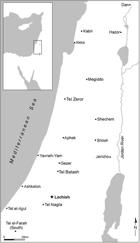
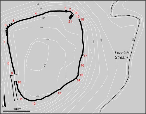
Figure 2. Tel Lachish, the nearby Lachish Stream, and a schematic representation of the ‘Revetment’. The 21 points marked around the site are discussed in the text.
This study has two objectives: to summarise the available data on this wall, emphasising 21 points along its circumference, and to analyse the implications of the new data for the dating of this construction.
II. History of the research
In 1847 Layard uncovered the palace of King Sennacherib in Nineveh and discovered the magnificent reliefs that depict the Assyrian siege of the city of Lachish in the Kingdom of Judah (Layard Citation1849). This historical event took place in the time of King Hezekiah (2 Kgs 18–19, 2 Chr 32, and Isa 36–37). The reliefs were brought to the British Museum and created great excitement at the time, as they were the first scientific demonstration of the authenticity of a biblical tradition (Larsen Citation2009; Garfinkel Citation2022). The identification of ancient Lachish at Tell ed-Duweir, however, was suggested only much later (Albright Citation1929).
Lachish has attracted much attention and has been excavated by different expeditions from 1932 up to the present day. Remains relating to the ‘Revetment’ were uncovered by the First Expedition (Tufnell, Inge, and Harding Citation1940; Tufnell Citation1953, Citation1958), the Ussishkin expedition (Citation1982, Citation2004) and the Fourth Expedition to Lachish (Garfinkel, Hasel, and Klingbeil Citation2013; Garfinkel et al. Citation2019a, Citation2019b, Citation2021a).
The first mention of the ‘Revetment’ is found in a letter sent by Starkey in London to H.-L. Vincent in Jerusalem on 18th October 1932, before the excavation started (British Museum Correspondence Files 47-63, Lachish, Identification of). Starkey argued that Tell ed-Duweir was ancient Lachish since this city is depicted with two city walls on the Sennacherib relief and there are two walls on the mound. It is thus clear that the ‘Revetment’ was dated in London before the excavation had even begun.
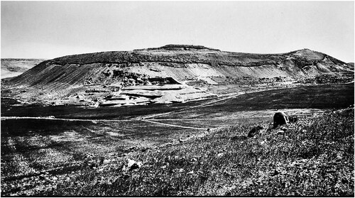
In the first season of 1932–3 the expedition uncovered the entire outer facade of the wall, c. 2 km in length, from the outside of the city by clearing the site’s slopes (Starkey Citation1933, 190–9) (). It was described thus:
An important result of this season’s work has been the clearance of much of the city’s later and outer defences. At each point where we have examined the ‘Revetment’ it is founded on bedrock, and in places is preserved to a height of 14 courses, or over 25 feet; it makes a complete circuit of the mound except for a section of about 100 feet which fell away during the last five years, and is built of regular courses of large limestone blocks, laid as dry walling. At the turn of the revetment at the north-east corner we found a well, within the angle of masonry, lined with stone to a depth of 26 feet and then cut through native rock until it reached water level 122 feet below the surface. From this corner, the ‘Revetment’ was traced along the north side of the mound, to the north-west corner, where five large buttresses strengthened it as it turned southwards, along the west side recessed back at intervals as it follows the contours of the mound. It forms a junction at the south-west corner with the great ‘bastion’, which, as mentioned previously, held the gateway’ (Starkey Citation1933, 197–8).
Figure 3. The ‘Revetment’, excavated around the entire site, appears as a dark line on the mid-slope of the tel: the eastern side with part of the southern side on the left and part of the northern side on the right (looking west) (courtesy of the Wellcome Trust archive, London).
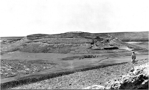
Figure 4. The ‘Revetment’, excavated around the entire site, appears as a dark line on the mid-slope of the tel: the northern side on the left and the western side on the right (looking east) (Starkey Citation1933, Pl. I, courtesy of the Wellcome Trust archive, London).
The excavators related this massive construction to Level IV of the Iron Age II. They assigned dates of c. 925 bc for its construction and 597 bc for its destruction. The former date was based on the biblical account of King Rehoboam’s fortification of Lachish (2 Chr 11:5–15), while the latter date was based on the alleged connection of a few seal impressions bearing the name Eliakim na‘ar Yokan with the biblical King Jehoiachin (Garfinkel Citation1990). Tufnell (Citation1953) later reassigned the destruction of Level III to the Assyrian assault of 701 bc.
Why did the First Expedition uncover the entire two-kilometer length of the wall? This is the most extensively exposed fortification system in the region, and perhaps in the entire Near East.
At the time it is reported that E.T. Richmond, the director of the Department of Antiquities of Palestine, visited the site in 1933, and ‘was particularly pleased with our intention of delimiting the town before opening up work in town levels’ (Starkey Citation1933–4, 12). Years later, Tufnell described and explained these activities as a planned strategy:
The investigation was begun early in the programme of work in order to delimit the site. It was hoped to establish the date of the defence system and to locate the main gateway and any postern entrances. With these ends in view, work was begun in 1932 on the north-east side of the mound (Tufnell Citation1953, 88).
As rightly stated by Ussishkin (Citation2014, 38), however, ‘Enormous effort was invested in this work, but in fact it contributed almost nothing to the understanding of the tell and its remains.’ Indeed, the reason for this work was apparently the dispute with the local landowners, who did not allow the expedition to excavate the top of the mound (Garfinkel Citation2016).
Ussishkin’s expedition re-exposed the ‘Revetment’ in Areas S, GW, and R, albeit only a few meters in each spot. New dates were suggested for the construction of this wall – c. 800 bc – and for its destruction – 701 bc (Ussishkin Citation2004). These expeditions, however, did not uncover any constructions superimposed on the wall, and no structures were found abutting the wall from inside the city. A field photograph of a one-course stone wall, that shows no stratigraphic relations, is presented as an indication for dating the ‘Revetment’ to the Iron Age (Ussishkin Citation2023, ).
The Ussishkin expedition debated two different interpretations of the superstructure of the ‘Revetment’:
The renewed excavations contribute no new information concerning the purpose of the Outer Revetment Wall. In Barkay’s view, its primary function was to prevent the enemy and its siege engines from reaching the Main City Wall, and it would have been possible to concentrate soldiers along it. Ussishkin, however, believes that the revetment wall was preserved nearly to its original height, and that it served merely as an outer revetment of the Main City Wall, which served as the main line of defence (Ussishkin Citation2004, 436).
The Fourth Expedition uncovered the ‘Revetment’ in two locations near the northeast corner of the site. In both locations this wall was in a stratigraphic relationship with superimposed Middle Bronze Age IIc and Late Bronze Age constructions. This implies that the wall was constructed in the Middle Bronze Age IIb, c. 1800 bc (Garfinkel et al. Citation2021a). This new dating has recently been criticised by Ussishkin (Citation2023).
III. A detailed inspection of the ‘Revetment’
The available data on the wall, starting from the northeast corner of the site and going around it counterclockwise, is presented. There are 21 specific points along the way that deserve close attention ():
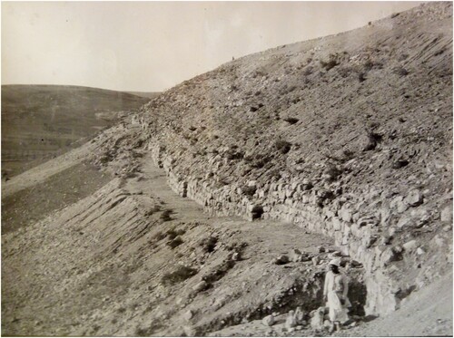
Point 1. A clear end of the massive ‘Revetment’ can be observed here. The width of the wall (2.5 m) was fully exposed and the entire outer façade was exposed as well, to a preserved height of up to 10 m. The wall was built on bedrock, making it more stable than a wall built on the earthen slope. This end was already observed by the First Expedition, who defined at this point the ‘blockage of a gate’ (; Tufnell Citation1953, Pl. 11:3).
Figure 5. The ‘Revetment’ near the northeast corner of the site as exposed by the First Expedition. Note that the massive wall on the right side of the picture ends in a straight vertical line, indicating its edge (Point 1). To the left there is a poorly built stone wall, that blocked the area further to the south (Point 20). This area had been designated by the First Expedition as a ‘blocking of a gate’ (Tufnell Citation1953, Pl. 11:3) (courtesy of the Wellcome Trust archive, London).
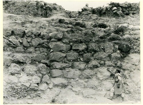
Figure 6. Plan of the northeast corner of Tel Lachish, showing the following points: 1. An end of the ‘Revetment’. 2. The northeast corner of the wall. 3. A tower. 20. A later wall abutting the ‘Revetment’ from the south. 21. A massive three-room mudbrick citadel dated to the Middle Bronze Age IIc.
Point 2. The northeast corner was built from massive stones, more carefully than in other parts of the wall (). A corner is a relatively weak part of a construction, and a weak point of the fortification, and this was taken into consideration by the builders. The corner was fully exposed by the First Expedition, however, today it is covered by modern stairs, stones, cement, and iron fencing erected in this location by the Israel Nature and Parks Authority for the benefit of tourists visiting the nearby forty-metre-deep well.
Figure 7. The northeast corner of the ‘Revetment’. Note the elaborate construction using massive, well-cut limestone blocks (courtesy of the Wellcome Trust archive, London).
Point 3. About 10 m from the corner the wall widens toward both the outside and the inside, pointing to the existence of a tower in this location. The other corners were also reinforced in various ways (Points 6, 12, 14). The mud bricks on top of the stone foundation contained Iron Age pottery. These sherds indicate that the superstructure of the tower was renewed during the Iron Age, nearly a thousand years after the original construction.
The corners of a site are weak points in the defence, a strategic problem discussed by Eph‘al (Citation1984). Indeed, the Assyrian attack on Lachish, and the constructed siege ramp, was located in the southwest corner. The topography of Lachish did not change between the Middle Bronze Age and the Iron Age. In both periods the corners of the site were exactly in the same location. Therefore, in both periods Points 3 and 12 needed protection from towers. Thus, the builders of the Iron Age city reused the stone foundations of the earlier Middle Bronze Age towers.
Point 4. On the north side of the site the ‘Revetment’ extends for some 500 m; its façade was built with salients and recesses, boosting its stability.
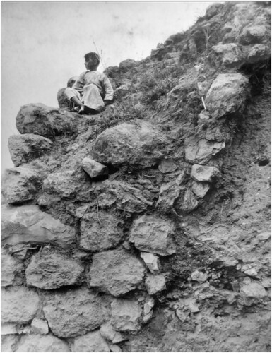
Point 5. Near the west end of the north side of the site, the First Expedition uncovered a Middle Bronze Age Cemetery 100, with burial caves cut in the limestone bedrock (, right). The excavators recognised a hard plastered surface on the steep slope, which they understood as a Middle Bronze Age ‘Hyksos glacis’ (Tufnell Citation1958). It should be noted, however, that this ‘plaster’ was recognised only at this spot, near the burial caves the excavation of which resulted in the dumping of large quantities of powdered limestone and gravel on the slope. This interpretation, therefore, cannot be accepted. In any case, at the time of excavation the Middle Bronze Age was known only to a limited extent. Since then, sections cut through Middle Bronze Age glacis have revealed complex earth-moving projects with alternating levels of soil, as reported, for example, at Gezer (Dever Citation1974a, 34–6; Seger Citation1975), Shechem (Dever Citation1974b; Seger Citation1975, 38) and Shiloh (Finkelstein, Bunimovitz and Lederman Citation1993, 41–3, Fig. 3.9). Nothing of this kind was found at Lachish. If there were a glacis around the site, it would have been uncovered in other parts of the site as well. We therefore conclude that there was no glacis at Lachish.
Figure 8. Seven thick buttresses located at the northwest corner of the site, supporting the corner (courtesy of the Wellcome Trust archive, London).
Point 6. The northwest corner of the wall was reinforced by seven massive buttresses abutting the ‘Revetment’ from the outside in a fan-like arrangement (, left). This area was described thus by Starkey at the end of the season:
The outer defenses at the N.W. corner, which were traced last year, have also been examined down to bedrock, where we now find a regular series of buttresses of great thickness; they differ in this respect from the lighter ones built at frequent intervals along the lower section of the wall throughout its circuit (Starkey Citation1934, 167).
Such buttresses have not been found, to the best of my knowledge, in any other site in the Levant. They probably represent a local need to strengthen the northwestern corner of Lachish, perhaps because the city wall underwent erosion at this location.
Point 7. Near the site’s northwest corner, the First Expedition identified a depression, which they dubbed a ‘fosse’. This was where the famous Fosse Temple was uncovered (Tufnell, Inge and Harding Citation1940). This ‘fosse’ was not recognised in any other spot at the site. Looking at the area’s topography, it seems that we have here a local creek that drained water northward to the nearby Lachish Stream.
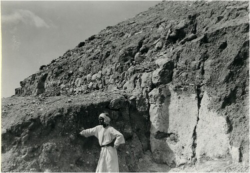
Point 8. On the west side of the site the ‘Revetment’ extends for another 500 m, and here too its façade was built with salients and recesses. An especially clear photograph of this phenomenon was published by the First Expedition ().
Figure 9. The ‘Revetment’ on the western side of the site. The façade was built with salients and recesses, which imparted additional strength to the construction (for a similar photograph see Tufnell Citation1953, Pl. 12:1, courtesy of the Wellcome Trust archive, London).
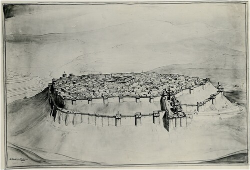
Point 9. Toward the southwest corner of the site a massive Iron Age gate was constructed in Level IV and rebuilt in Levels II (Tufnell Citation1953). The First Expedition suggested that the ‘Revetment’ joined the north face of the Iron Age gate, a connection that was presented in a pleasing artistic reconstruction of the Iron Age city drawn early in the first season, before the gate was even fully exposed (; Starkey Citation1933, Pl. III lower). A connection between the ‘Revetment’ and the Iron Age gate was presented in a later reconstruction of the Iron Age city as well (Ussishkin Citation1982, 29, ; Citation2004, 85, Fig. 3.1; Citation2014, Fig. 12.9). This connection, however, is not physically present at the site, as will be shown below, in Section IV.2.
Figure 10. Artistic reconstruction of the Iron Age city of Tel Lachish. The city is presented with two walls encircling it, one at the top of the site and the other (the ‘Revetment’) located further down the slope. The city is shown looking east. Note that the ‘Revetment’ abuts the Iron Age gate. The reconstruction was drawn in the middle of the First Expedition’s first season of fieldwork, when little of the Iron Age city had yet been exposed (Starkey Citation1933, Pl. III, courtesy of the Wellcome Trust archive, London).
Point 10. This point is located on the south side of the Iron Age gate. This is another supposed meeting point between the ‘Revetment’ and the gate of Levels IV–III and II. As can be seen in the field today, and in photographs taken during excavation (Ussishkin Citation2004, Figs. 11.22, 11.28 and 11.39), the south wall of the gate complex was in fact built on top of the ‘Revetment’. The first four-metre section of the ‘Revetment’ adjacent to the gate clearly has two phases, an earlier one constructed with the original large building stones and a later repair carried out with smaller stones. It is possible that this repair was made when the gate was built. In any case, the construction of the gate again post-dates the ‘Revetment’.
Point 11. Toward the southwest corner of the site the ‘Revetment’ is built at a higher level than Point 10. In this location the slope is more moderate than in other areas around the site, and it seems that the ‘Revetment’ was built at a higher level here in order to create a more prominent corner.
Point 12. Area R of the Ussishkin expedition was located at this point. Here a section cut through the Assyrian siege ramp exposed a narrow section of the ‘Revetment’ (Ussishkin Citation2004, Fig. 13.6; Garfinkel et al. Citation2021b). A massive brick tower was found here, destroyed by fire in 701 bc by the Assyrians. Apparently, as observed in Point 3, the mud brick superstructure had been rebuilt in the Iron Age.
Point 13. On the south side of the site the ‘Revetment’ extends for another 500 m, and here too its façade was built with salients and recesses.
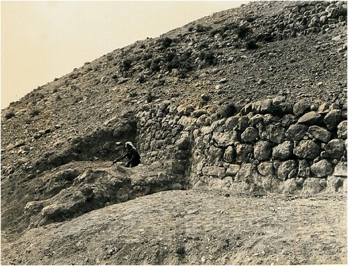
Point 14. A few meters from the southeast corner of the site, a tower was unearthed by the First Expedition. As at Point 3 near the northeast corner and Point 5 at the northwest corner, the wall was reinforced by a tower near the corner.
Point 15. This is the southeast corner of the city (). To give the city a fully symmetrical shape, this point would have had to be constructed further to the southeast. The steep natural slope in this location probably forced the constructors to place the corner at this point.
Figure 11. The southeast corner of the ‘Revetment’. (Point 15) (Tufnell Citation1953, Pl. 11:4, courtesy of the Wellcome Trust archive, London).
Point 16. On the east side of the site the ‘Revetment’, its façade built with salients and recesses, extends for another 500 m. At some point not far from the southeast corner, a plastered installation was built against the wall (, Tufnell Citation1953). The date and function of this installation are unknown. As it was built against the outer façade of the wall and no pottery was published from this location, it is not clear if it was in use immediately after the construction of the ‘Revetment’ or in a later period.
Figure 12. The eastern side of the ‘Revetment’, with a plastered installation abutting it from outside the city (Point 16) (Tufnell Citation1953, Pl. 12:6, courtesy of the Wellcome Trust archive, London).
Point 17. A few hundred meters north of the southeast corner of the site, a tower was unearthed by the First Expedition. As at Point 3 near the northeast corner and Point 14 in the southeast corner, the structure protruded from the outside of the wall. This location is unique at Lachish, as such towers were otherwise observed only in the corners of the site. As the wall curves at this spot, the builders probably felt a need to strengthen the construction here.
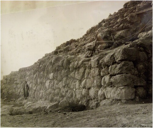
Point 18. Another end of the massive ‘Revetment’ is clearly seen here. The entire outer façade was exposed, showing that the wall was built on bedrock. It was preserved to a height of 13 courses (). As can be seen in , the inner side of the wall was better preserved than the outer side. This is the result of natural erosion, in which the exposed side on the slope is eroded faster than the side that is buried on the inside. It is clear that the wall was originally higher than its current preservation. Point 18 is similar to Point 1, as each represents an end of the ‘Revetment’.
Figure 13. The edge of the ‘Revetment’ on the east side of Tel Lachish (Point 19, the lower part). Note that the massive wall was built on bedrock and still standing to a height of 13 courses (courtesy of the Wellcome Trust archive, London).
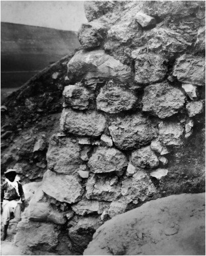
Figure 14. The edge of the ‘Revetment’ on the east side of Tel Lachish (Point 19, the upper part). The wall does not stand upright but is tilted toward the city, like a terrace wall (Tufnell Citation1953, Pl. 11:5, courtesy of the Wellcome Trust archive, London).
In this location the First Expedition made a section through the site’s slope, in which different levels of sediment accumulated behind the wall were observed. The pottery reported from here dated from the Middle Bronze Age II in the lower levels and from the Late Bronze Age in the upper levels (Tufnell Citation1953, 87–8; Tufnell Citation1958, 44).
The wall does not stand upright but was built at a slope, like a terrace wall. This has implications for the interpretation of the entire construction. On the inside of the city the wall was not free-standing, as one would expect from a city wall. Hence, it seems that at least in this location the purpose of the wall was to retain sediments piled up against its inner side. Such massive retaining walls are known in a number of Middle Bronze Age cities, where great efforts were made to manipulate the urban landscape and to give the site a geometric shape that changed the local topography (Kaplan Citation1975; Kempinski Citation1992; Herzog Citation1997; Burke Citation2008).
Point 19. This is a gap of c. 50 m in the ‘Revetment’, an area described by the end of the first excavation season as ‘about 100 feet which fell away during the last five years’ (Starkey Citation1933, 197). The idea that part of the ‘Revetment’ fell away seems unlikely, as both ends of the gap, Point 1 in the north and Point 18 in the south, are well defined. In addition, a recently collapsed massive wall should leave tumbled stones at the foot of the mound; however, no such collapsed stones were observed.
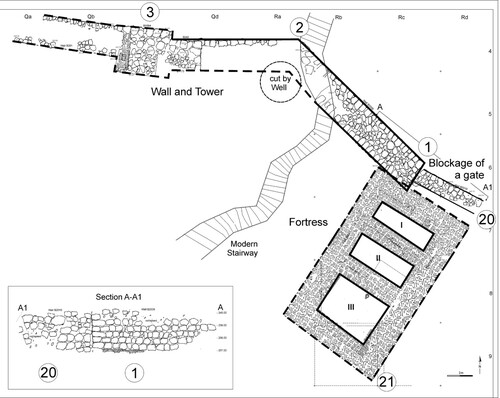
Point 20. Within the gap a massive wall (Wall 2010), though not as massive as the ‘Revetment’, is built against Point 1. It is clear that it runs up to Point 1, but in a slightly different orientation (, left side). This wall was observed by the First Expedition and defined as the ‘blocking of a gate’ (Tufnell Citation1953, Pl. 11:3). The slightly different orientation of this wall fits the orientation of the massive mudbrick fortress (Point 21). Wall 2010 appears to have been built to support the construction of the fortress and marked its limit on the east.
Point 21. Above Wall 2010 and in the same orientation, which is somewhat different from that of the ‘Revetment’, the Fourth Expedition unearthed a large brick fortress (, ). This building is approximately 8 × 14 m in size and has massive walls up to 2 m thick and up to 4.4 m in height. It was destroyed in a fierce conflagration that was clearly attested by the rich accumulation of ash, charcoal, and burnt mudbrick debris. The citadel follows the slope, and hence the east room is lower than the middle room, while the west wall is higher. Four scarabs and nearly 30 impressed sealings, all typical of the end of the Middle Bronze Age (c. 1550 bc), were found. This date is supported by radiometric datings (Garfinkel et al. Citation2019b) and corresponds with the end of the so-called Hyksos period and the beginning of New Kingdom Egypt.
Figure 15. Aerial photograph showing the end of the ‘Revetment’ (Point 1), the later wall (Point 20), and the massive mudbrick citadel with its three rooms (Point 21).
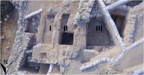
The Lachish fortress is similar in plan to contemporary fortresses at Jericho, Gezer, and Ebla (Nigro et al. Citation2011, 573–7; Kempinski Citation1992; Matthiae Citation2001; de Miroschedji Citation2018, Fig. 21). These fortresses are all located adjacent to the city wall, often near a city gate. At Lachish the location of this fortress near the gap in the city wall (Point 19) makes it more likely that there was indeed a city gate in this location.
The important point here is the stratigraphic relationship between three components: the ‘Revetment’, Wall 2010 and the Hyksos fortress. The 16th-century bc fortress and Wall 2010 are in the same orientation, and were built together. They are later than the ‘Revetment’, as Wall 2010 abuts the ‘Revetment’ from the south and the fortress was built above Wall 2010 and the ‘Revetment’. Thus the ‘Revetment’ should be dated to an earlier phase of the Middle Bronze Age, some time in the 18th century bc.
IV. Dating the ‘Revetment’
Three major aspects should be taken into account when dating the ‘Revetment’ of Lachish, all of which became apparent only recently:
When the dating was decided. The dating of the massive wall was decided in London, before the excavation started. As already observed by Tufnell (Citation1950, 78), ‘The archaeological evidence for the constructional date of these magnificent walls will not be conclusive until further cross sections are made.’
The foundation trench in Point 9. The claim of a connection between the ‘Revetment’ and the Iron Age gate is critical for the dating issue. The Ussishkin expedition examined the gate complex, which is composed of three units: an outer gate, a large open courtyard, and an inner gate. But despite the graphic reconstruction, which depicts a buttress at the connection point (Ussishkin Citation1982, ), a different situation is evident in the area plans (Ussishkin Citation2004, Figs. 10.1, 10.3, 11.43, 11:63) and in a field photograph (Ussishkin Citation2004, :66; Citation2014, Fig. 12.9). The picture in the popular publication by Ussishkin (Citation2014, Fig. 12.9) shows the situation better than any other publication. Here the massive wall of the ‘Revetment’ stops a few meters before the northern wall of the gate. The foundation trench between the two walls is filled with earth and small stones.
Similarly, the text describing this area gives a different picture: ‘However, the three meters of the revetment nearest the northern wall of the courtyard was different from the rest of the wall, showing inferior workmanship and built of smaller stones.’ (Ussishkin Citation2004, 578). He strongly emphasised that the ‘Revetment’ is connected to the Iron Age gate (Ussishkin Citation2004, Fig. 10.1; the text states ‘physical connection’).
However, the field photographs clearly show the end of the massive ‘Revetment’, while the last few meters are merely earth and stone fill rather than a construction (Ussishkin Citation2004, 579, 11:66; Citation2014, Fig. 12.9). This is clearly not ‘inferior workmanship’ but an obvious gap between the end of the ‘Revetment’ and the north side of the gate complex. What we see here is a foundation trench of the Iron Age gate that cut through the earlier massive wall and was then filled with stones. This foundation trench had been overlooked by the excavator. The implication of this new observation is very clear: the ‘Revetment’ is earlier then the fortifications of Level IV.
The 50 m gap between points 19 and 1. If the ‘Revetment’ is an Iron Age construction, we need to explain why, in a two-kilometer fortification encircling the city, 50 m were left open on the east side of the site. It seems likely that this is the location of the entrance to the Middle Bronze Age city. The possibility that a gate is located in this spot was also briefly raised by Tufnell (Citation1953, 92). The topographically lower northeast corner of the city is the closest spot to the nearby valley and the stream, which provide the city with a number of important advantages:
Water. Convenient access to water is crucial for a city. For regular daily life, as well as for herds of animals, the stream was a vital water resource.
Agricultural fields. A large segment of the population of the city were probably farmers who cultivated agricultural land around the site. The terrain surrounding Lachish is quite hilly and the limestone bedrock is exposed in large parts of the area. Even today, despite modern technologies such as irrigation and the extensive use of chemical fertilisers, the hills around the site remain uncultivated. Modern agricultural activity in the vicinity is concentrated in the valleys, making use of their alluvial soil. In antiquity too agricultural activity was necessarily concentrated in the valley on either side of the stream.
Clay. Most of the buildings in the city were built of mudbrick. The production of mudbricks requires clay and water, and the stream is a constant supplier of both. A study of the mudbricks from the site showed that in many cases the materials originated from alluvial soils at the foot of the slope (Rosen Citation2004). Taking into account the heavy burden of carrying tons of brick into the city, the stream bank closest to the site must have been the location preferred by the people of Lachish for the manufacture of bricks.
Road. The Lachish Stream flows from the Hebron Hills in the east to the coastal plain and Ashkelon in the west. Lachish is situated about one day’s walk from Ashkelon (c. 30 km) and one day’s walk from Hebron (c. 25 km). This was a highly strategic location for one of the most important roads in this part of the country. Even today there is a modern road nearby leading from the coastal plain into the hills.
Taking all these advantages into account, and in the absence of any clear resources on the other sides of the site, the city was most likely approached from the valley at the site’s northeast corner. Indeed, in this location there is a relatively moderate slope from the valley to the top of the site. Even today, the Israel Nature and Parks Authority has built a path and steps leading to the site in this location. In fact, in the first map of Lachish, completed in 1932 by the Department of Antiquities of Palestine for the excavation permit of Starkey’s expedition, the only path leading up the site follows this route.
As of today, the gate to the Middle and Late Bronze Age cities of Lachish remains undiscovered. This is in contrast to the Iron Age levels, in which there was a massive gate construction near the southwest corner of the site (Points 9 and 10). Ussishkin suggested that the Bronze Age gates were also located somewhere in this location, but had not yet been discovered (2014, 227). However, the entire Middle Bronze Age wall was exposed by the First Expedition and no gate opening was observed in this area. Thus, there is no reason to look for a gate in the southwest corner (Garfinkel et al. Citation2019a).
The gap of c. 50 m in the wall is wider than Middle Bronze Age city gates, which were commonly no wider than 10–15 m or so altogether (Kaplan Citation1975, Figs. 8–17; Gregori Citation1986; Herzog Citation1986). Moreover, neither of the ends of the wall (Points 1 and 18) is connected to any structure. It is possible that a monumental entrance to the city was located here, and a nearby fortress (Point 21).
V. Ussishkin Critique
Strong opposition to the new data about the city wall of Level V and the ‘Revetment’ was raised by the previous excavator of Lachish (Ussishkin Citation2023). According to Ussishkin, Level V was not fortified, and the wall uncovered in our excavations in the northeastern corner of Lachish was part of the fortification system of Levels IV–III of the ninth to eighth centuries bc. Detailed discussions of the dating of the city wall of Level V were previously presented, refuting Ussishkin’s claims, and will not be repeated here (Garfinkel and Hasel Citation2021; Kang, Chang and Garfinkel Citation2023). Ussishkin also defended the 90-year-old dating of the ‘Revetment’ to Levels IV–III. In this way he combined three different fortification systems into one: the mudbrick city wall of Levels IV–III, the stone wall of Level V and the ‘Revetment’ of the Middle Bronze Age. Needless to say, there is not even one site in the entire Near East that was encircled by three parallel city walls. To the best of my knowledge, there is not a single city with two parallel city walls in the Levant.
Regarding the Middle Bronze Age, Ussishkin raised two points:
During the Middle Bronze Age Lachish was surrounded by a glacis coated by a layer of lime plaster, and a fosse was hewn along the bottom of the mound as concluded by Starkey and his colleagues (Ussishkin Citation2023, 92).
The outer revetment which surrounds the mound at mid-slope was built and functioned in Levels IV–III of Iron Age II (Ussishkin Citation2023, 92).
The first point is not relevant to the ‘Revetment’, but to the question whether Lachish had a glacis during the Middle Bronze Age. Ussishkin simply repeated the data published by Tufnell, without any critical analysis (Ussishkin Citation2023, 96–9, ). Like Tufnell before, he related several layers of whitish sediment in a limited distribution on the northwest side of the mound to a glacis, and that this glacis was coated with a layer of plaster. However, above the whitish sediment Middle Bronze Age burial caves of Cemetery 100 were cut into the local limestone bedrock (Point 5). The quarried sediments from the caves were dumped on the slope. This explains why the ‘glacis’ was found only at this spot. If a glacis created the squarish shape of the site, why was it not found in any other part of the 2 km area around the site?
Ussishkin (Citation2023, 93) described the outer face of the glacis as covered with ‘a mantle of white lime’. However, producing white plaster involves burning limestone at temperatures of about 850 degrees. In order to cover the whole mound, it would have been necessary to burn tens of thousands of tons of limestone in kilns, and this layer of plaster would be washed away by rain after one winter. Therefore, Tufnell’s observations regarding the plastered coating must be rejected.
Ussishkin mentioned that the massive stone buttresses (Point 6) that abut the ‘Revetment’ were founded on bedrock and cut into white sediments. However, clearly shows that whitish sediment is found only to the east of the buttresses, in the area of the burial caves. It is not even clear if the buttresses were cut into sediment, or were free standing, since Starkey’s expedition had cut all around them.
Ussishkin (Citation2023, ) presents one small test pit from his excavations, titled ‘The outer revetment, the fills supporting its inner side, and the underlying, white-plastered surface at the bottom’. However, this test pit does not show the inner side of the ‘Revetment’, nor its base, nor a white-plastered surface. It is not even clear if this wall is indeed the ‘Revetment’ or a maybe a later construction built on top of the ‘Revetment’, or just a wall on the site. It is also not clear if this area had been disturbed during Starkey’s excavations in the years 1923 to 1938.
The last point about the ‘glacis’ is the existence of a supposed ‘fosse’, near the northwestern corner of Lachish. Ussishkin described it as a ‘Portion of the rock-hewn fosse at the foot of the glacis in the northwest corner of the mound’ (Ussishkin Citation2023, 95–6). However, nothing in this area looks like a man-made trench, and it appears to be a small natural creek, that drains the small valley located to the west of the site into the Lachish river. Starkey’s expedition looked for a fosse in the northeastern corner of the site but only found another cemetery there.
As I understand the data, the geometrical shape of Lachish was determined by the massive stone ‘Revetment’ wall, that until now has been wrongly dated to the Iron Age.
In his long discussion Ussishkin completely ignored Point 9, where his expedition observed a connection between the ‘Revetment’ and the Iron Age gate of Levels IV–III Iron Age gate. This supposed connection already appears in a reconstruction of the city made during the first excavation season, in winter 1934. At this stage the ‘Revetment’ or the city gate were not yet excavated. In the site, the ‘Revetment’ wall stops about three meters before the city gate. There is clearly a foundation trench here (Ussishkin Citation2004, :66; Citation2014, Fig. 12.9), and the Revetment predates Level IV. Thus, the entire reconstruction of Lachish as a city surrounded by several city walls is not supported by the data.
Ussishkin (Citation2023) also ignored his own earlier suggestion to connect the ‘Revetment’ with the city wall of Levels IV–III on top of the slope, ‘its main function being to retain the glacis or ramp resting on the slope above it, which in turn supported the base of the Main City Wall. Remains of the stone mantle of the glacis were uncovered in Area S and can still be seen at many points around the site’ (Ussishkin Citation2004:80). However, such ‘glacis’, ‘ramp’ or ‘stone mantle’ were never found. Thus, there are no stratigraphic connections between the Iron Age city wall of Levels IV–III and the ‘Revetment’, not at Point 9, nor by an imaginary glacis.
VI. The ‘Revetment’ Wall in its Middle Bronze Age Context
Dating the ‘Revetment’ to the Iron Age creates an anomaly: no other example of an Iron Age city fortified by two contemporary walls is known in the region. After excavation of hundreds of Iron Age cities in the Levant, Lachish would be unique in having one mudbrick city wall on top of the mound and another massive stone wall located at mid-slope. It is now clear that this is an erroneous picture, created by the combination of two different fortification systems with a difference of a millennium in their date.
The Middle Bronze Age was the zenith of urbanism in the Levant, and the later periods of the Late Bronze and Iron Ages never reached the same density and quality of demographic capacity, public enterprise, and economic prosperity (Broshi and Gophna Citation1986; Dever Citation1987; Herzog Citation1997). The fortifications of the Middle Bronze Age are among the most impressive constructions in the region, and they are still prominent in the landscape today. Over the years many scholars have dealt with the technical aspects and function of these fortifications (see, for example, Yadin Citation1972; Dever Citation1974a, Citation1974b; Kaplan Citation1975; Seger Citation1975; Gregori Citation1986; Herzog Citation1986; Kempinski Citation1992; Burke Citation2008). Other scholars emphasise the social aspect as well (Bunimovitz Citation1992; Finkelstein Citation1992; Uziel Citation2010).
It is clear that Middle Bronze Age fortifications manipulated the landscape and often created geometrically-shaped sites. This was achieved by constructing massive walls of square or rounded outline around a site and dumping sediments inside to create a podium-like enclosure. Such a massive Middle Bronze Age wall was constructed at Lachish.
VII. Discussion
Before the development of sensitive stratigraphic methods, a detailed pottery sequence, and radiometric dating, buildings and levels in the southern Levant were dated in accordance with the biblical tradition or Egyptian or Mesopotamian sources. Consequently, early archaeological research in the region suffered from circular arguments, as exemplified by the case study of Lachish. Initially, the Lachish relief was used to strengthen the identification of Tell ed-Duweir as ancient Lachish and to date the ‘Revetment’ to the Iron Age.
Some scholars have taken the relief as an accurate representation of the Iron Age city of Lachish and the Assyrian battle. Petrie wrote:
This testing of a sculpture excavated in Assyria, hundreds of miles distant from the place, is of great interest, as it shows that some sketches and notes were actually made, probably by a royal designer attached to the court, one of the secretaries (Petrie Citation1891, 37–8, as well as Starkey 1993 and; Ussishkin Citation1982).
Some scholars, however, emphasise the artistic aspect of the Assyrian reliefs, their role in royal propaganda and the various difficulties posed by their interpretation (Jacoby Citation1991; Winter Citation1997; Smoak Citation2008). Thus, the relief cannot be used to date the ‘Revetment’.
Conclusion
The ‘Revetment’ was a massive retaining wall of the Middle Bronze Age, which gave Lachish its squarish shape, typical of the period.
References
- Albright, W. F., 1929. ‘The American Excavations at Tell Beit Mirsim’, Zeitschrift für die Alttestamentliche Wissenschaft 47, 1–17.
- Broshi, M. and Gophna, R., 1986. ‘Middle Bronze Age II Palestine: Its Settlements and Population’, Bulletin of the American Schools of Oriental Research 261, 73–90.
- Burke, A., 2008. Walled Up to Heaven: The Evolution of Middle Bronze Age Fortification Strategies in the Levant, Winona Lake, IN: Eisenbrauns.
- Bunimovitz, S., 1992. ‘The Middle Bronze Age Fortifications in Palestine as a Social Phenomenon’, Tel Aviv 19, 221–34.
- De Miroschedji, P., 2018. ‘The Early Bronze Age Fortifications at Tel Yarmut – An Update’, Eretz-Israel 33, 142–62.
- Dever, W. G., 1974a. Gezer II: Report of the 1967–70 Seasons in Fields I and II, Jerusalem: Hebrew Union College.
- Dever, W. G., 1974b. ‘The MB IIC Stratification in the Northwest Gate Area at Shechem’, Bulletin of the American Schools of Oriental Research 216, 31–52.
- Dever, W. G., 1987. ‘Archaeological Sources for the History of Palestine: The Middle Bronze Age: The Zenith of the Urban Canaanite Era’, BA 50, 149–77.
- Eph‘al, I. 1984, ‘The Assyrian Siege Ramp at Lachish: Military and Lexical Aspects’, Tel Aviv 11, 60–70.
- Finkelstein, I., 1992. ‘Middle Bronze Age ‘Fortifications’: A Reflection of Social Organization and Political Formations’, Tel Aviv 19, 201–20.
- Finkelstein, I., Bunimovitz, S. and Lederman Z., 1993. Shiloh: The Archaeology of a Biblical Site, Tel Aviv: Institute of Archaeology, Tel Aviv University.
- Garfinkel, Y., 1990. ‘The Eliakim Na‘ar Yokan Seal Impressions: Sixty Years of Confusion in Biblical Archaeological Research’, BA 53, 74–9.
- Garfinkel, Y., 2016. ‘The Murder of James Lesley Starkey Near Lachish’, PEQ 148, 84–109.
- Garfinkel, Y., 2022. ‘Lachish in the Context of Ancient Near Eastern Studies’ in C. Rollston, S. Garfein and N.H. Walls (eds) Biblical and Ancient Near Eastern Studies in Honor of P. Kyle McCarter Jr., Ancient Near East Monographs 27, Atlanta: SBL Press, 505–24.
- Garfinkel, Y. and Hasel, M. G. 2021. ‘A Brief Replay to D. Ussishkin Remarks Concerning the Fortifications at Lachish’, Qadmoniot 54 (161), 54–5 (Hebrew).
- Garfinkel, Y., Hasel, M. G. and Klingbeil, M. G., 2013. ‘An Ending and a Beginning: Why We’re Leaving Qeiyafa and Going to Lachish’, Biblical Archaeology Review 39, 44–51.
- Garfinkel, Y., et al., 2019a. ‘Lachish Fortifications and State Formation in the Biblical Kingdom of Judah in Light of Radiometric Datings’, Radiocarbon 61, 695–714.
- Garfinkel, Y., et al., 2019b. ‘First Impression on the Urban Layout of the Last Canaanite City of Lachish: A View from the Northeast’, in A. Maeir (ed.), The Late Bronze and Early Iron Ages of Southern Canaan, Berlin: de Gruyter, 122–35.
- Garfinkel, Y., et al., 2021a. ‘The Canaanite and Judean Cities of Lachish, Israel: Preliminary Report of the Fourth Expedition 2013–2017’, AJA 125(3), 419–59.
- Garfinkel, Y., et al. 2021b. ‘Constructing the Assyrian Siege Ramp at Lachish: Texts, Iconography, Archaeology and Photogrammetry’, Oxford Journal of Archaeology 40, 417–39.
- Gregori, B., 1986. ‘Three-Entrance City-Gates of the Middle Bronze Age in Syria and Palestine’, Levant 18, 83–102.
- Herzog, Z., 1986. Das Stadttor in Israel und in den Nachbarländern, Mainz am Rhein: Philipp von Zabern.
- Herzog, Z., 1997. Archaeology of the City: Urban Planning in Ancient Israel and its Social Implications, Tel Aviv: Institute of Archaeology, Tel Aviv University.
- Jacoby, R., 1991. ‘The Representation and Identification of Cities on Assyrian Reliefs’, IEJ 41, 112–31.
- Kang, H.-G., Chang, S.-Y. and Y. Garfinkel, Y., 2023. ‘The Level V City Wall at Lachish’, PEQ 155, 135–45.
- Kaplan, J., 1975. ‘Further Aspects of the Middle Bronze Age II Fortifications in Palestine’, Zeitschrift des Deutschen Palästina-Vereins 91, 1–17.
- Kempinski, A., 1992. ‘Middle and Late Bronze Age Fortifications’, in A. Kempinski and R. Reich (eds), The Architecture of Ancient Israel: from the Prehistoric to the Persian Periods, Jerusalem: Israel Exploration Society, 127–42.
- Kochavi, M., Beck, P. and Gophna, R., 1979. ‘Aphek-Antipatris, Tel Poleg, Tel Zeror and Tel Burga: Four Fortified Sites of the Middle Bronze Age IIA in the Sharon Plain’, Zeitschrift des Deutschen Palästina-Vereins 95, 121–65.
- Larsen, T., 2009. ‘Austen Henry Layard’s Nineveh: The Bible and Archaeology in Victorian Britain’, Journal of Religious History 33, 66–81.
- Layard, A. H., 1849. Nineveh and Its Remains, London: Murray.
- Matthiae, P., 2001. ‘A Preliminary Note on the MB I–II Fortifications System at Ebla’, Damaszener Mitteilungen 13, 29–51.
- Petrie, W. M. F. 1891. Tell el Hesy (Lachish). London: Palestine Exploration Fund.
- Nigro, L., et al., 2011. ‘The Bronze Age Palace and Fortifications at Tell es-Sultan/Jericho, the 6th–7th Seasons (2010–2011)’, Scienze dell’antichità 17, 571–97.
- Reich, R., 2011. Excavating the City of David, Jerusalem: Israel Exploration Society.
- Regev, J., et al., 2017. ‘Absolute Dating of the Gihon Spring Fortifications, Jerusalem’, Radiocarbon 59, 1171–93.
- Rosen, A. M., 2004. ‘Mudbrick Analyses’ in D. Ussishkin (ed), The Renewed Archaeological Excavations at Lachish (1973–1994), Tel Aviv: Institute of Archaeology, Tel Aviv University, 2582–92.
- Seger, J. D., 1975. ‘The MB II Fortifications at Shechem and Gezer: A Hyksos Retrospective’, Eretz-Israel 12, 34–45.
- Starkey, J. L., 1933. ‘A Lecture Delivered at the Rooms of the Palestine Exploration Fund, on June 22nd, 1933’, PEQ 65, 190–9.
- Starkey, J. L., 1933–4. Wellcome Archaeological Research Expedition to the Near East, Tell Ed Duweir, Field Reports, Season 1933–1934, unpublished manuscript in the British Museum and the Wellcome Trust, London.
- Starkey, J. L., 1934. ‘Excavations at Tell el-Duweir, 1933–1934’, PEQ 66, 164–75.
- Smoak, J. D. 2008. ‘Assyrian Siege Warfare Imagery and the Background of a Biblical Curse, in B.E. Kelle and F.R. Ames (eds), Writing and Reading War: Rhetoric, Gender, and Ethics in Biblical and Modern Contexts, Atlanta: Society of Biblical Literature, 83–91.
- Tufnell, O., 1950. ‘Excavations at Tell Ed-Duweir, Palestine, Directed by the Late J. L. Starkey, 1932–1938’, PEQ 82, 65–80.
- Tufnell, O., 1953. Lachish III: The Iron Age, London: Oxford University Press.
- Tufnell, O., 1958. Lachish IV: The Bronze Age, London: Oxford University Press.
- Tufnell, O., Inge, C. and Harding, G. L., 1940. Lachish II: The Fosse Temple, London: Oxford University Press.
- Ussishkin, D., 1982. The Conquest of Lachish by Sennacherib, Tel Aviv: Institute of Archaeology, Tel Aviv University.
- Ussishkin, D., 2004. The Renewed Archaeological Excavations at Lachish (1973–1994), Tel Aviv: Institute of Archaeology, Tel Aviv University.
- Ussishkin, D., 2014. Biblical Lachish. A Tale of Construction, Destruction, Excavations and Restoration, Jerusalem: Israel Exploration Society.
- Ussishkin, D., 2023. ‘The City Walls of Lachish: Response to Yosef Garfinkel, Michael Hasel, Martin Klingbeil and Their Colleagues’, PEQ 155, 91–110.
- Winter, I. J. 1997. ‘Art in Empire: the Royal Image and the Visual Dimensions of Assyrian Ideology’ in S. Parpóla and R.M. Whiting (eds), Assyria 1995: Proceedings of the 10th Anniversary Symposium of the Neo-Assyrian Text Corpus Project, Helsinki, September 7–11, 1995, Helsinki: The Neo-Assyrian Text Corpus Project, 359–81.
- Uziel, J., 2010. ‘Middle Bronze Age Ramparts: Functional and Symbolic Structures’, PEQ 142, 24–30.
- Yadin, Y., 1972. Hazor, The Head of All Those Kingdoms: The Schweich Lectures of the British Academy, 1970, Oxford: Oxford University Press.
- Yadin, Y., 1978. The Nature of the Settlements During the Middle Bronze IIA Period in Israel and the Problem of the Aphek Fortifications, Zeitschrift des Deutschen Palästina-Vereins 94, 1–23.
