Abstract
This article examines the potential geographic inequities between major hazard events and U.S. presidential disaster declarations at the county level from 1965 through 2004. The previous literature suggests that the disaster declaration process is highly politicized and not necessarily based on need. We hypothesize that there is a spatial inequity between the receipt of disaster declarations and the distribution of major hazard events. The results indicate that the geographic distribution of disaster declarations is not totally explained by the spatial pattern of major hazard events. In some locales, state experience in submitting disaster requests and achieving success translates into more disaster declarations (holding everything else constant), providing further evidence of the political nature of the process.

En este artículo se analizan las incongruencias geográficas potenciales entre los desastres importantes y las declaraciones sobre desastres presentadas por el presidente de Estados Unidos a nivel de condado entre 1965 y 2004. La literatura existente sugiere que el proceso de declaración de desastres está altamente politizado y no se basa precisamente en la necesidad. Nuestra hipótesis es que existe una incongruencia espacial entre el recibo de declaraciones de desastre y la distribución de eventos de emergencia importantes. Los resultados indican que el patrón espacial de los eventos de emergencia importantes no explica totalmente la distribución geográfica de las declaraciones de desastre. En algunos lugares, la experiencia de los estados en la presentación de solicitudes de asistencia para un desastre y el recibo de tal asistencia se traduce en más declaraciones de desastre (en las que todo lo demás permanece constante), lo cual hace más evidente la naturaleza política del proceso.
In the past few years, the United States has experienced a large number of natural disasters resulting in billions of dollars in economic losses. Of particular note are the two record-breaking hurricane seasons in 2004 and 2005. Four major hurricanes (Charley, Frances, Ivan, and Jeanne) struck Florida in 2004, breaking the previous record of landfalls for a single state that had stood since 1933 (National Climatic Data Center [NCDC] 2004). Estimates suggested that the 2004 hurricane season caused more than forty-two billion dollars in damage, which at the time was the most costly hurricane season ever for the United States (NCDC 2004). The following year was even more disastrous and record-breaking. The 2005 Atlantic hurricane season was the most active period since hurricane counting started in 1851, with twenty-seven named storms and an extraordinary number of Category 5 hurricanes (Katrina, Rita, and Wilma; NCDC 2006). Damage estimates exceed one hundred billion dollars for Hurricane Katrina alone (NCDC 2006). These back-to-back devastating hurricane seasons illustrated shortcomings in existing emergency management at all levels, especially the federal response to disasters. They also highlighted the magnitude of spending in response to major disasters.
A recent study found little statistical correlation or spatial association between economic losses (property and crop damage) from natural hazards and the occurrence of presidential disaster declarations (PDDs; Cutter and Emrich 2005). There were two explanations for the disparities between the hazard losses and disaster declarations. First, the definition of total hazard losses incorporated all hazard events including more chronic, less devastating events, whereas PDDs and disasters were larger and more costly singular events. Due to the difference in the definition of an event, little geographic overlap was expected. Second, the authors speculated that the political nature of the disaster declaration process implied a certain level of political effectiveness in garnering such designations, but measures of the political and electoral importance of the state were not included in their study (CitationCutter and Emrich 2005).
This article seeks to clarify the relationship between hazard events and PDDs examined by CitationCutter and Emrich (2005) by focusing more explicitly on the occurrence of hazard events with losses exceeding a set threshold to obtain a better measure of a disaster. Specifically, this article examines the spatial relationship between major hazard events and PDDs at the county scale for a forty-year time period (1965–2004). We define major hazard events as those county-specific events where the losses exceed the 95th percentile in total hazard losses for our period of record, or roughly those hazard events resulting in more than $1.58 million (2004 dollars) in losses for a county. We hypothesize that there are geographic inequities between major hazard events and PDDs. We suggest that these inequities are not based solely on the distribution of major hazard losses, but rather on political factors operating at state and regional levels such as the effectiveness of the states in garnering PDDs. To address the role of state effectiveness in getting a disaster declaration, we examined the relationship between PDD success rate for states and Federal Emergency Management Agency (FEMA) regions, in addition to the number of major hazard events and the number of PDDs.
The Disaster Declaration Process
The Robert T. Stafford Disaster Relief and Emergency Assistance Act (hereinafter the Stafford Act) and its subsequent amendments (Robert T. Stafford Disaster Relief and Emergency Assistance Act 2000) provide the policy framework for federal disaster assistance. States are required to take appropriate action under existing state law, to execute their state emergency operation plans, and to certify that state and local cost shares will be in compliance with federal requirements. The law mandates a minimum 75 percent federal share of costs for declared disasters, with state and local resources covering the remaining 25 percent. Due to the lack of predefined thresholds or definitions, the federal share is implemented irrespective of the state or local ability to pay the costs, and often regardless of the magnitude of the disaster.
FEMA outlines the specific procedures for requesting PDDs (FEMA 2006). After a disaster event occurs, state and federal officials immediately conduct damage assessments to determine the extent of losses and the resources necessary for recovery. In most cases, these assessments must be completed before the governor can request a disaster declaration from the president. The disaster declaration request goes from the governor of the affected state to the regional FEMA office for review and then to the head of FEMA/Department of Homeland Security (DHS). The FEMA/DHS officials make a recommendation to the president, who ultimately decides whether the losses satisfy the Stafford Act's broad criteria for a disaster declaration (FEMA 2006). For a declaration to be issued, the event must be found to be of such “severity and magnitude that effective response is beyond the capabilities of the State and the affected local governments and that Federal assistance is necessary” (Robert T. Stafford Disaster Relief and Emergency Assistance Act 2000 § 5170). FEMA prescribes the process for requesting PDDs by local and state governments, and implemented per capita loss guidelines in their request review process (FEMA 1999), but there are no definitions of “effective response” or “beyond the capabilities of the State and the affected local governments” in either an absolute or relative sense that are binding on the president when making the final determination. Further, Congress has explicitly prohibited any binding threshold criteria for obtaining a presidential declaration, or a formula for guiding aid distribution (CitationBurby et al. 1991; CitationPlatt 1999). As a result, there is an opportunity for politics to play a role in all aspects of the disaster declaration process.
The Politics of Disaster Declarations
Previous research suggests a number of shortcomings in the federal disaster relief policy. Individual responsibility for the costs of living in hazard-prone areas has been replaced by an expectation that the federal government will provide for recovery from disasters (CitationPlatt 1999; CitationCastelazo and Garrett 2003). Some studies document that the PDD process is inordinately influenced by political considerations (CitationSylves 1996, Citation2007; CitationDownton and Pielke 2001; CitationGarrett and Sobel 2003). Another concern is that politicians are reluctant to vote against postdisaster appropriations as their constituents might be the next ones affected (CitationMoss 1999). Some critics observed that PDDs are a new form of pork barrel spending (CitationPlatt 1999, Citation2000), comparable in magnitude to the construction of flood control works from the 1930s to 1950s (CitationWright 1996). Finally, the management of federal disaster spending has been criticized as well (CitationCastelazo and Garrett 2003).
The most prevalent theme in the literature is the likely influence of politics or other non-needs-based considerations on the disaster declaration process (CitationMay 1985; CitationSylves 1996; CitationPlatt 1999). For example, CitationMay (1985) suggested that the declaration process was susceptible to political influence at the gubernatorial level, at the federal level through the presidential and legislative branches, as well as through federal agencies. He also noted voters tended to reward politicians who were seen as successful in securing postdisaster federal assistance. CitationSylves (1996) found media attention leveraged the federal response to the California flood events of 1995, a response described by one of his interviewees as purely political.
Few studies have examined the quantitative relationship between the number of PDDs and the variables that influence the declaration process. Those that do can be divided into spatial and longitudinal categories. In addition to CitationCutter and Emrich (2005), the spatial analysis of PDDs is limited to Platt's (1999) visual interpretation of county and state maps classified by the number, mean value, and total per capita value of the disaster declarations for a six-year study period (January 1989–April 1995). Platt provided a subjective assessment of political influence by comparing declarations in similar or adjacent locales with differing political importance. He pointed out that because no measures of risk or vulnerability were included he was unable to conclude definitively that differences in declaration frequency resulted from political considerations. In another study, CitationBurby et al. (1991) found that per capita natural disaster losses among the smallest cities and counties in the United States (from 1980–1987) were almost three times larger than losses for the largest, yet these smaller places did not receive more disaster declarations. Their finding suggested that an empirical relationship might exist between population size, on which Electoral College votes (and by extension electoral importance) are based, and declared disasters.
More recent studies examined PDDs using longitudinal analyses at the national and state levels. CitationDownton and Pielke (2001) considered the physical dimensions of flooding events in conjunction with political measures that might influence the declaration process using data from 1965 to 1998. According to their findings, reported flooding damages explained only 32 percent of the variance in the number of PDDs. The state's ability to pay for the flooding events, measured as per capita damages reported in National Weather Service flood loss estimates from 1983 to 1997, explained only 12 percent. They concluded that changes in federal disaster policies, political administrations, and the occurrence of presidential reelection years were the major factors influencing flood PDDs during their study period.
In another longitudinal study, CitationGarrett and Sobel (2003) constructed two empirical models with data from 1991 to 1999: one analyzed the influence of presidential politics on the number of PDDs, and the other considered the influence of congressional politics on the dollar amount of disaster relief at the state level. In their presidential model, they found that the number of PDDs at the state level was related to the electoral importance of the state. Electoral importance was determined by considering the number of presidential electoral votes and a numerical measure of the state's “battleground” status. In their analysis of congressional political influences, CitationGarrett and Sobel (2003) found that states with congressional representation on FEMA oversight committees, particularly in the House of Representatives, were likely to receive more money from disaster declaration assistance. More specifically, they found that 44.5 percent of the disaster payments to states coincided with House membership on these FEMA oversight committees. The frequency and funding magnitude for PDDs increased at a statistically significant level during the 1996 election year. Although the results from both the congressional and presidential models did show relationships between declarations and levels of insured losses and Red Cross disaster spending, Garrett and Sobel concluded that “nearly half of all FEMA disaster relief is explained by political influence rather than actual need” (CitationGarrett and Sobel 2003, 508).
Each of these studies argued that although PDDs were based to some extent on the occurrences of hazard events, they were also subject to high levels of political influence. The extant literature provides some understanding of the influence of politics and political change on the disaster declaration process, but it does have several limitations. Most observed that politics generally influenced PDDs based on subjective interpretation of maps, or on knowledge gained from more detailed case studies of specific events or hazards (CitationMay 1985; CitationSylves 1996; CitationPlatt 1999). The few empirically based studies that examined the relationships between disasters and PDDs (CitationDownton and Pielke 2001; CitationGarrett and Sobel 2003) have done so longitudinally, used broad geographic divisions or limited time periods, or considered only certain hazard types (e.g., floods). There are few empirically based spatial analyses of the relationship between disasters and declarations at the substate levels of geography in the United States.
One reason for this is that, as CitationPlatt (1999) noted, the paucity of data presents challenges when comparing PDDs to levels of risk and vulnerability at finer spatial scales. Although Downton and Pielke (2001) and CitationGarrett and Sobel (2003) attempted to address this issue by adjusting their analyses at national and state levels to consider flood losses and precipitation levels, and private property insurance claims and Red Cross disaster assistance, respectively, they did not do so in an inherently spatial manner, nor did they provide spatially differentiated results.
When taken as a whole, this literature suggests that the processes influencing PDDs operate simultaneously at various scales. Hazard events range in scale from local to regional, and are not spatially constrained by jurisdictional boundaries. The political considerations observed by both CitationDownton and Pielke (2001) and CitationGarrett and Sobel (2003) are relevant, however, and come into play at the state level. Finally, we suspect that the potential for political influence through federal agencies suggested by CitationMay (1985) might be expressed in differences in declarations across FEMA regions. Given the paucity of spatially informed analyses of long-term data, this article is a timely contribution to our understanding of disaster relief policy.
Study Area and Data Sources
The primary purpose of this article is to investigate the spatial relationship between major hazard events and PDDs at the county level for the United States. A secondary purpose is to determine whether the spatial variability is a function of the state's historical success in obtaining PDDs. Our study was conducted for the conterminous United States using longitudinal records of major hazard events and PDDs at the county level from 1965 through 2004. We fully recognize the limitations in using such an analysis given changes in disaster policy, political administrations, economic fluctuations, and changes in the social geography of counties. Temporal differences such as CitationGarrett and Sobel's (2003) finding of significant increases in disaster declarations during election years, for example, are important, but we feel they may be moderated by our longer period of analysis. The variability of individual administrations and election year cycles should smooth out over the forty-year period of record and convey a more consistent spatial pattern.
The Spatial Hazard Events and Losses Database for the United States (SHELDUS) (Hazards Research Lab 2006) provided the number of major natural hazard events and associated losses for each county from 1965 to 2004. The SHELDUS is a geo-referenced compilation of hazards data reported by various government agencies such as the National Weather Service and U.S. Geological Survey (USGS), classified into eighteen types of natural hazards. Approximately 365,000 county hazard event records were reported in the SHELDUS between 1965 and 2004 for the entire United States. Because of temporal changes in county boundaries during the past four decades, all county delineations were standardized to 2000 county boundaries.
Data recording PDDs at the county level for the same period were obtained by the authors from unpublished FEMA sources and subjected to a rigorous quality control and assurance process to verify county locations. This list was also supplemented by a database hosted by the Public Entity Risk Institute (PERI 2006).
Eleven events outside the scope of the SHELDUS database are included in the PERI disaster declaration database, notably the declarations associated with the terror attacks of 11 September 2001, the 1995 Oklahoma City bombing, and the 1993 World Trade Center bombing; and the 1992 Los Angeles riots, the impacts of an El Niño year on salmon fisheries, and the occurrence of toxic algae in coastal waters. Because events of these types were not included in the SHELDUS, these eleven declarations were excluded from our analysis.
The total number of PDDs included in the analysis was 1,249, which represents the number of discrete events, not all the counties affected by them. When disaggregated by county, the total is much higher (19,472), as each declaration often includes multiple counties.
The data from PERI also contained information regarding the total number of denied state requests for disaster assistance for the period from 1965 to 2004. This information was used to derive request success rates for each state and FEMA region (PERI 2006). The declaration request success rates were used as indicators of political and procedural experience at the state and regional levels.
When using the broadest classification scheme possible—hydrometeorological, geophysical, and wildfires—the vast majority of county-level PDDs included in this study were hydrometeorological events (97.6 percent). Using this same broad classification scheme for the hazard event data again showed the dominance of hydrometeorological events (99.5 percent) as causes of major hazard events.
Variability in Major Hazard Events and Disaster Declarations
Statistical Relationships
PDDs result, by definition, from large and relatively infrequent events that exceed the capacity of state and local governments to respond to them. The hazard event data, on the other hand, are recorded instances where hazards produced some notable damage, death, or injury. Hazard events include more frequent, lesser impact events, resulting in monetary loss well below that of a disaster. In many ways, we would not expect a strong relationship between the frequency of all events and a disaster declaration, and this is confirmed statistically. A simple Spearman's correlation test showed a positive and statistically significant relationship between the number of all hazard events and PDDs, but the association was weak (R s = 0.232,p < 0.01). Even when controlling for population size, area, and population density, the relationship between all hazard events and disaster declarations remained weak.
For this article, the hazard event data were subset to include only low-probability, high-impact events, those that most closely resemble disasters, to counteract the problem identified by CitationCutter and Emrich (2005). Total constant dollar losses for each county, as reported in SHELDUS, were used to identify the 95th percentile hazard events, the assumption being that these were the most likely events to result in a disaster declaration for that county. A total of 18,278 county hazard events exceeded the ninety-fifth percentile break (with losses greater than $1.58 million in 2004 dollars) and we labeled these major hazard events. The correlation between the number of declared disasters and major hazard events improved, yet remains weak (R s = 0.370,p < 0.01).
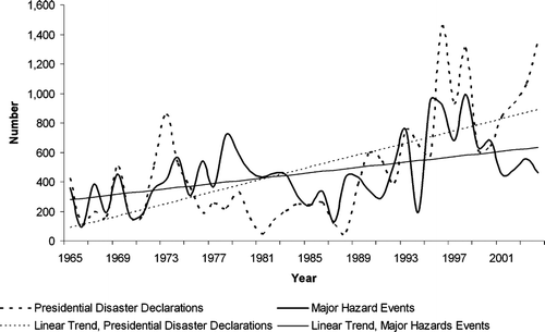
As expected, there is considerable temporal variability in the annual occurrence of PDDs and major hazard events for the conterminous United States (). In both cases the trend lines show steady increases, with the number of PDDs showing the most rapid growth.
Figure 1 Annual major hazard events and disaster declarations from 1965 to 2004.
Spatial Patterns
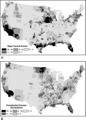
Major hazard events and PDDs were mapped by county to visualize their respective distributions. The distribution of major hazards shows a distinct clustering in the upper Great Plains regions (largely due to tornadoes and flooding), along the Gulf Coast (tropical storms and hurricanes), and southern California (wildfires, earthquakes; ). A number of state boundaries are clearly identifiable (Iowa, Idaho, South Carolina, Florida, Arizona, and California), artifacts most likely the result of reporting discrepancies in the original data or the procedures used to disaggregate the data in the SHELDUS. For PDDs, the spatial pattern is slightly different (). Here, North Dakota stands out (flooding), but southern California, Gulf Coast counties stretching from Texas to Florida (tropical storms), and the Great Plains region are also clearly visible. One obvious difference is the cluster of Appalachian counties that received more than fifteen PDDs, yet had relatively few major hazard events, as we have defined them.
Figure 2 Disasters 1965–2004: (A) Total number of major hazard events by county. (B) Total number of presidential disaster declarations (PDDs) by county.
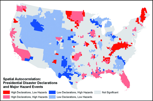
Following the approach employed by CitationCutter and Emrich (2005), a bivariate local Moran's I analysis identified areas with a significant spatial association (p ≤ 0.05) between the occurrence of PDDs and the major hazard events (). Areas of convergence (low declarations–low hazards, high declarations–high hazards areas) include the upper Great Plains (high), the Intermountain West (low), the Gulf Coast (high), Florida (high), California (high), and the Puget Sound region (high). Areas of divergence (low declarations–high hazards, high hazards–low declarations) result in a de facto spatial inequity. These inequities are seen in Appalachia, Maine, the western Great Plains, southern Idaho, the Savannah River Basin in the Southeast, and in western Texas. One could argue that high declaration–low hazard regions (Appalachia, Maine) are receiving more federal assistance than warranted based on the occurrence of major hazard events. At the same time, we see that portions of the country might be underserved by PDDs, given the relative infrequency in number compared to the larger number of major hazard events (southern Idaho, western Texas). The question is what accounts for such spatial inequities?
Figure 3 Local spatial association between presidential disaster declarations (PDDs) and major hazard events calculated using a bivariate local Moran's I.
State and Regional Success
To explore influences that could be contributing to this spatial inequity between PDDs and major hazard events, each county was assigned a state and regional success rate, defined as the proportion of state requests for PDDs approved from 1965 to 2004 for the state, and then within the FEMA region (PERI 2006; ). The hypothesis was that a state's experience or success in getting a disaster declaration or being within a FEMA region that was adept at the process could account for some of the spatial variability between PDDs and the occurrence of large-magnitude events. To assess the influence of state and regional success in garnering PDDs a regression analysis was performed in which the number of major hazard events, state, and regional success rates were used as independent variables. Although this model was significant and shows that both regional and state success rates are important (), it provides only a very weak explanation (adjusted R 2 = 0.231, p < 0.001) for the number of PDDs.
Table 1 PDD success rates: 1965–2004
Table 2 Variables used to predict the number of presidential disaster declarations (PDDs) in the global regression model
Geographically weighted regression (GWR) provides another useful analytical approach for identifying the relationships between these variables by creating a set of regression models, each one fit for an individual county in the study area. For instance, in the standard regression analysis, a single model (termed a global model) estimated the influence of major hazards, and state and regional success rates on PDDs for the entire United States. In the GWR analysis, a different local regression model, estimating the influence of major hazards, and state and regional success rates on PDDs, was fit for each county. Each local regression included only values for the nearest 441 counties (for details on the approach used to derive this optimal neighborhood size, see CitationBrundson, Fotheringham, and Charlton 1998). Additionally, the influence of the values in the neighboring counties was weighted based on proximity, so that closer counties had a greater influence on the results of the regression than those further away (CitationBrundson, Fotheringham, and Charlton 1996). The GWR analysis resulted in a set of 3,109 local regressions for this study, one regression for each county.
The benefits of the GWR approach are threefold. First, specific statistical tests can be applied that determine the explanatory power of the set of regressions in the GWR as a whole and then compare the set to the single global regression model (CitationBrundson, Fotheringham, and Charlton 1999). These tests essentially evaluate the usefulness of the GWR approach. Second, the spatial variability of the regression parameters (intercepts and slope coefficients for each independent variable) can be tested (CitationBrundson, Fotheringham, and Charlton 1998). The occurrence of significant spatial variation indicates that the fundamental relationships between the independent variables and the dependent variables changes across the study region. Finally, maps of GWR output can be produced showing the visualization of spatial variations of regression diagnostics (such as goodness-of-fit measures) and parameters (such as intercept and slope coefficients). Both provide a picture of how the relationships between the independent and dependent variables change across space. The GWR algorithms used in this analysis were implemented in the GWR 3.0 software package.
The analysis of the GWR results, and their comparison to the global model, revealed that the GWR analysis had a statistically significant difference from the global regression model, and provided greater explanatory power (adjustedR 2 = 0.493). The differences in all model parameters across space were found to be statistically significant as well (p < 0.001). This tells us that the GWR analysis is more useful than the global model in describing the relationships between major hazard events, state and regional success rates, and PDDs. It also tells us that the influence of the occurrence of major hazard events and state and regional success rates on the occurrence of PDDs varies across space.
A major challenge of GWR analysis is that the volume of results generated makes interpretation very complex. To address this issue, we begin our discussion of the GWR results using two exemplar areas: Chambers County, Texas, and Harding County, South Dakota (). Chambers County, located along the coast just east of Galveston, had seventeen major hazard events and five PDDs during the study period. Harding County, located in the northwest corner of South Dakota, had only one major hazard event (a winter blizzard), yet also received five PDDs. Indeed, Chambers is included in the Low Declaration, High Hazard classification in , whereas Harding is in the Low Declaration, Low Hazard classification. Differences between theR 2value for the local regressions indicate that the model parameters explain a substantially larger percentage of the variation in the PDDs awarded for Harding (R 2 = 0.78) than for Chambers (R 2 = 0.44). Comparing the regression coefficients for the two counties reveals the differing influence of the same variables in each area. Looking at the slope coefficients for major hazards, we see that in Harding, with a coefficient of 0.83, the occurrence of a major hazard event is expected to result in more PDDs than in Chambers, with a coefficient of 0.23. The state success rate coefficients suggest that increases in success rates are expected to result in more PDDs in Harding than in Chambers. The regional success rate coefficients show that increases in regional success rates in Harding result in expected increases in PDDs, whereas in Chambers, increases in the regional success rate result in expected decreases in PDDs.
Table 3 Two-county example from the geographically weighted regression model
Differences in intercept coefficients are also important. Statistically significant variations in intercept coefficients suggest the presence of some other spatial process or variable influencing the analysis (CitationBrundson, Fotheringham, and Charlton 1999). The negative intercept value for Harding and the positive intercept value for Chambers suggest that there is some other factor not included in the model accounting for the difference between these two study areas that increases the occurrence of PDDs in Chambers and decreases them in Harding.
Taken as a whole, the GWR results reveal that in Harding, there is a closer match between the independent variables and the PDDs. Increases in all predictors result in greater expected increases of PDDs for Harding than for Chambers. Yet, when compared to the positive intercept value for Chambers, Harding's negative intercept suggests that there are other factors influencing the relationship among the four variables, which results in a decrease in the number of expected PDDs.
This same basic approach can be applied in interpreting the maps of GWR results by county shown in and . shows the spatial distribution of the local R 2 values for the set of regressions generated by the GWR. Variations in these values show that the strength of the relationship among major hazard events, state, and regional success rates and PDDs are different for counties across the United States. This means that in some areas, such as parts of Alabama, the Southwest, and in the western Great Plains, the occurrence of county-level PDDs can be explained by the variations in the occurrence of large hazard events, as well as state and regional success in acquiring PDDs. In other areas, such as in the Northeast and Midwest, the occurrence of county-level PDDs is not well explained by the independent variables.
Figure 4 R2 values of the local regressions conducted for each county using geographically weighted regression, with presidential disaster declarations as the dependent variable and major hazard events, state success rate, and regional success rate as the independent variables.
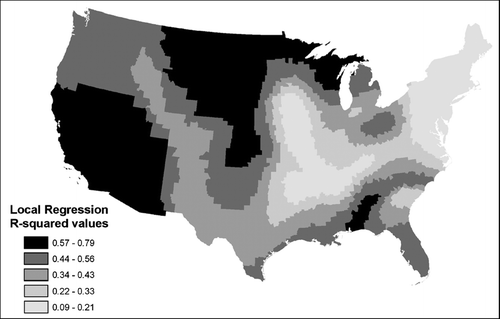
Figure 5 Parameter values of the local regression conducted for each county using geographically weighted regression: (A) intercept values, (B) coefficients for the major hazard event variable, (C) coefficients for the state success rate variable, (D) coefficients for the regional success rate variable.
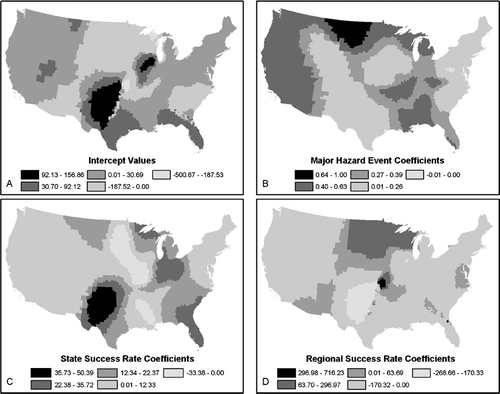
shows the spatial distributions of the model parameters. The major hazard slope coefficient (), holding all else constant, is positively related to PDD occurrence throughout the majority of the country, with the highest values occurring around the Dakotas, in the far West, and in the South. Counties throughout the Great Plains and Rocky Mountain regions and along the eastern seaboard from Maine to the Carolinas have very low values for this coefficient. This suggests that holding the other variables constant, the occurrence of major hazard events in counties in these areas is expected to result in fewer PDDs than elsewhere in the country. This is not surprising given the general spatial pattern of counties with higher slope coefficients for major hazard events shown in loosely corresponds to the areas with a closer match between the patterns of major hazard events and PDDs ().
and show the spatial distribution of the state and regional success rate coefficients. In general, increases in state success rates relate to the strongest expected increases in PDDs in portions of the southern Great Plains and northward from Florida to the Great Lakes. Increases in state success rates are related to much weaker expected increases, or even decreases, in PDDs throughout the majority of the West and in the Northeast. The majority of counties in the United States experience a negative relationship between PDDs and regional success rates; exceptions to this are found mainly in the northern Plains states and in the Southwest (). These spatial differences in state and regional success rate coefficients could be related to differences in the areal extents of the predominant types of major hazard events in these areas such as droughts or flooding. This is especially true of the northern Great Plains region. In other areas, occurrence of discrete hazard events (tornadoes) might result in a mismatch between state and regional success rates and the number of hazard events, as PDDs are awarded for a more limited number of counties within the state or region at a time.
Finally, reveals the spatial patterns of the significant differences in the intercept variable, again suggesting some other spatially distributed process influencing the occurrence of PDDs. Taken with the evidence from other research (CitationDownton and Pielke 2001; CitationGarrett and Sobel 2003), it seems likely that this could result from political influences beyond the success of states and FEMA regions in garnering PDDs. The intercept values range from –500.67 to 156.86, but the majority of counties have positive intercept values. The strongest positive intercept values are found in the southern Plains. Negative intercept values are found primarily in and around the Carolinas and Georgia, the northern Great Plains, and parts of the Southwest. In these regions factors other than the major hazard events or state and regional success rates in obtaining disaster declarations act to reduce the expected number of county PDDs.
Concluding Thoughts and Policy Implications
There was steady growth in the number of PDDs and in the number of major hazard events from the mid-1960s to the present. Although the statistical association between the number of declarations and number of major hazard events across the United States as a whole is rather weak, the local associations are much stronger. Counties in the Great Plains, Gulf Coast, Puget Sound, Florida, and California have higher numbers of declarations and major hazard events. Similarly, fewer declarations and major hazard events are found in the Mountain West. A spatial inequity occurs in southern Idaho, portions of western Texas, and portions of the Southeast where relatively low numbers of declarations were awarded, yet there were higher numbers of major hazard events. The opposite is true for counties in Maine, the Dakotas, and Appalachia, where higher numbers of declarations were received, yet there were relatively few major hazard events.
The geographic inequalities in the receipt of PDDs are not solely based on the pattern of major hazard events. There are many counties and states in the United States that are underserved by the process (receiving fewer PDDs than expected based on the number of major hazard events), as well as many that are overserved (e.g., receiving a greater number of PDDs than expected). This conclusion is tempered by the consideration that the selection of the major hazard events used to compare PDDs in this article was based on the total dollar losses of an event, rather than the per capita losses, or the dollar losses relative to local wealth. This could mean that high-impact hazard events were underrepresented in the analysis for poorer areas where hazard losses that were below the monetary threshold used might have resulted in large impacts triggering a PDD. This could explain why the Appalachian region shows up as being “overserved.”
The success of the state and FEMA region where counties are located also affected the occurrence of PDDs. In general, the number of PDDs is expected to increase as the state's success at garnering them increased when accounting for the occurrence of large hazard events, but the relationship seems much stronger in certain areas. The reverse is true for regional success rates, with the majority of counties showing negative relationships between regional rates and the occurrence of PDDs.
The influence of hazard events, state, and regional success on PDDs varies across the country, suggesting that past and current standards for PDDs do not result in equitable distributions of federal disaster assistance. Counties in states like California and Florida, with large numbers of major hazard events and PDDs, still receive a disproportionate share of PDDs when controlling for the number of major hazard events, state, and regional success rates, as shown by the GWR slope and intercept values. Future research should incorporate measures of state political importance, such as those used by CitationGarrett and Sobell (2003), to identify if these political influences help to explain the differential spatial pattern of PDDs.
An obvious policy direction is to align the receipt of PDDs so they more closely match the occurrence of major hazard events. Other authors observed that reducing the inequities in the outcome of the disaster declaration process would require significant policy changes (CitationCastelazo and Garrett 2003). Castelazo and Garrett (2003, 11) state that “by strengthening the guidelines for disaster declaration and aid disbursement” we can better ensure that federal disaster aid is used as it is intended. For example, minimum thresholds for requests could be made more explicit and binding on the president, using measures such as per capita losses or losses as a proportion of the economic activity in the stricken area. The relative impact of the loss on the county and the state (measured in both economic and social terms) should be the guiding principle. Thresholds should be set high enough so that only those events that are truly disasters qualify. The federal cost share for a declaration could also be more explicitly tied to the impacts of the event, rather than arbitrarily set. In these ways, the discretion of the president to issue and Congress to fund PDDs would be tempered. Such an approach would remove the opportunity for political pressures unrelated to the event itself to influence the declaration process, meaning that PDDs would be issued based on need alone. This might result in a decrease in PDDs, requiring locals to rely on their own resources to respond to lower impact hazard events. By standardizing the process and removing the “discretion without accountability” from the executive and legislative branches, the bar could be raised so that only truly disastrous situations become the domain of the federal government response. Such a federal disaster policy would decrease the incentives for state and local governments to rely on federal assistance for smaller impact events yet retain the compassion, safety net, and recovery assistance for those communities truly devastated after the disaster.
MATHEW C. SCHMIDTLEIN is a PhD candidate in the Department of Geography and a research associate at the Hazards & Vulnerability Research Institute in the Department of Geography at the University of South Carolina, Columbia, SC 29208. E-mail: [email protected]. His research interests are in hazards, vulnerability science, and the application of GIScience to hazards research.
CHRISTINA FINCH is the GIS Manager of the Hazards & Vulnerability Research Institute in the Department of Geography at the University of South Carolina, Columbia, SC 29208. E-mail: [email protected]. Her research interests are in hazards, vulnerability science, and mitigation planning.
SUSAN L. CUTTER is a Carolina Distinguished Professor and Director of the Hazards & Vulnerability Research Institute in the Department of Geography at the University of South Carolina, Columbia, SC 29208. E-mail: [email protected]. Her research interests are in hazards and vulnerability science.
Notes
∗p < 0.001.
∗We wish to thank the anonymous reviewers and the editor for their constructive criticisms, all of which helped to improve this article. We also want to thank M. Gall, K. Borden, B. Boruff, K. Freer, and C. Emrich who critiqued earlier versions of the article.
Related Research Data
Literature Cited
- Brundson , C. , Fotheringham , A. S. and Charlton , M. E. 1996 . Geographically weighted regression: A method for exploring spatial nonstationarity . Geographical Analysis , 28 ( 4 ) : 281 – 98 .
- Brundson , C. , Fotheringham , A. S. and Charlton , M. E. 1998 . Geographically weighted regression—Modeling spatial non-stationarity . Journal of The Royal Statistical Society Series D—The Statistician , 47 : 431 – 43 .
- Brundson , C. , Fotheringham , A. S. and Charlton , M. E. 1999 . Some notes on parametric significance tests for geographically weighted regression . Journal of Regional Science , 39 ( 3 ) : 497 – 524 .
- Burby , R. J. , Cigler , B. A. , French , S. P. , Kaiser , E. J. , Kartez , J. , Roenigk , D. , Weist , D. and Whitington , D. 1991 . Sharing environmental risks: How to control governments' losses in natural disasters , Boulder, CO : Westview .
- Castelazo , M. D. and Garrett , T. A. 2003 . Politicians see silver lining . The Regional Economist , : 10 – 11 . July
- Cutter , S. L. and Emrich , C. 2005 . Are natural hazards and disaster losses in the U.S. increasing? . EOS, Transactions, American Geophysical Union , 86 ( 41 ) : 381 388 – 89 .
- Downton , M. W. and Pielke , R. A. Jr. 2001 . Discretion without accountability: Politics, flood damage, and climate . Natural Hazards Review , 2 ( 4 ) : 157 – 66 .
- FEMA . 1999 . Disaster assistance; factors considered when evaluating a governor's request for a major disaster declaration . Federal Register , 64 ( 169 ) : 47697 – 99 .
- FEMA . 2006 . A guide to the disaster declaration process and federal disaster assistance http://www.fema.gov/pdf/rebuild/recover/dec_proc.pdf(last accessed 5 July 2007)
- Garrett , T. A. and Sobel , R. S. 2003 . The political economy of FEMA disaster payments . Economic Inquiry , 41 ( 3 ) : 496 – 509 .
- GWR 3.0. Maynooth, County Kildare , Ireland : National Centre for Geocomputation, National University of Ireland .
- Hazards Research Lab . 2006 . The Spatial Hazard Events and Losses Database for the United States, Version 4.1 , Columbia : University of South Carolina . http://www.sheldus.org(last accessed 30 January 2007)
- May , P. J. 1985 . Recovering from catastrophes: Federal disaster relief policy and politics , Westport, CT : Greenwood Press .
- Moss , D. A. 1999 . “ Courting disaster? The transformation of federal disaster policy since 1803 ” . In The financing of catastrophe risk , Edited by: Froot , K. A. 307 – 55 . Chicago : University of Chicago Press .
- NCDC . 2004 . Climate of 2004 Atlantic Hurricane Season http://www.ncdc.noaa.gov/oa/climate/research/2004/hurricanes04.html(last accessed 5 July 2007)
- NCDC . 2006 . Climate of 2005 Atlantic Hurricane Season http://www.ncdc.noaa.gov/oa/climate/research/2005/hurricanes05.html(last accessed 5 July 2007)
- PERI . 2006 . All about PDDs http://www.peripresdecusa.org/mainframe.htm(last accessed 5 July 2007)
- Platt , R. H. 1999 . Disasters and democracy: The politics of extreme natural events , Washington, DC : Island Press .
- Platt , R. H. 2000 . Extreme natural events: Some issues for public policy http://www.isse.ucar.edu/extremes/papers/platt.PDF Discussion paper presented at the Extreme Events Workshop, Boulder, CO, 7–9 June 2000 (last accessed 5 July 2007)
- 2000 . Robert T. Stafford Disaster Relief and Emergency Assistance Act U.S. Code 42. § § 5121–5206
- Sylves , R. T. 1996 . The politics and administration of PDDs: The California floods of winter 1995 , Boulder : Natural Hazards Center, University of Colorado . http://www.colorado.edu/hazards/research/qr/qr86.html Quick Response Research Report 86 (last accessed 5 July 2007)
- Sylves , R. T. 2007 . “ Federal emergency management comes of age: 1979–2001 ” . In Emergency management: The American experience, 1900–2005 , Edited by: Rubin , C. B. 111 – 59 . Washington, DC : Public Entity Risk Institute .
- Wright , J. M. 1996 . “ Effects of the flood on national policy: Some achievements, major challenges remain ” . In The great flood of 1993: Causes, impacts and responses , Edited by: Changnon , S. A. 245 – 75 . Boulder, CO : Westview .