
Abstract
Drones have equipped geographers with the capacity to collect high-quality geospatial data at multiple spatial, spectral, and temporal resolutions. Although the adoption of drones is increasing across geography, knowledge of those using this technology and their practices is limited. The purpose of this article is to understand who is using drones in geography, how they are using them, and what future opportunities exist. We collected data from eighty-eight survey respondents, predominantly based in the United States but a handful from Australia, Canada, the European Union, and the United Kingdom. The findings from our Web-based survey show that about 85 percent of geographers using drones are White. Female respondents made up only about 30 percent of respondents, although they represented about 75 percent of the eighteen to twenty-four age group. Although the word drone has a negative connotation, most users (∼38 percent) prefer it, followed by unmanned aerial vehicle (∼21 percent) and unmanned aerial systems (∼19 percent). Only 22 percent of geographers have more than six years of drone experience, suggesting the rapid growth in use and popularity among geographers. Off-the-shelf drones are the most desirable, perhaps due to their low cost and ease of use. Overall, drones in geography are considered positive and have introduced a new era of small extent geospatial analyses.
无人机为地理学者提供了高质量的多空间分辨率、多光谱和多时间分辨率空间数据。尽管无人机在地理学界的使用越来越普遍, 我们却很少了解使用这种技术的人员及其实践。本文旨在理解地理学界中谁在使用无人机、如何使用无人机和未来的机遇。我们收集了88名受访者数据, 主要来自美国, 少数来自澳大利亚、加拿大、欧盟和英国。网络调查结果显示, 约85%使用无人机的地理学者是白人。女性受访者仅占所有受访者的30%左右, 她们在18至24岁年龄组中约占75%。虽然“无人机”(drone)有负面含义, 大多数用户(约38%)喜欢这个词, 其次是“无人驾驶飞行器”(unmanned aerial vehicle)(约21%)和“无人驾驶飞行系统”(unmanned aerial systems)(约19%)。只有22%的地理学者有六年以上无人机工作经验, 表明地理学者使用和喜爱无人机的程度在迅速增长。成品无人机最受欢迎, 可能是因为它们成本低、使用方便。总体来说, 地理学界认为无人机是有益的, 它开创了小区域地理分析的新时代。
Los drones han provisto a los geógrafos de la capacidad de recoger datos geoespaciales de alta calidad a múltiples resoluciones espaciales, espectrales y temporales. Aunque la adopción de drones se está incrementando en geografía, el conocimiento de quienes aplican esta tecnología, y sus prácticas, es todavía limitado. El propósito de este artículo es comprender quién está usando drones en geografía, cómo los están usando y qué oportunidades futuras existen. Recogimos datos de ochenta y ocho encuestados, predominantemente de Estados Unidos, aunque también unos cuantos más, de Australia, Canadá, la Unión Europea y el Reino Unido. Los resultados de nuestra encuesta a través de Internet muestran que cerca del 85 por ciento de los geógrafos que usan drones son blancos. Las mujeres son apenas un 30 por ciento de los encuestados, aunque ellas representan alrededor del 75 por ciento del grupo de edad de dieciocho a veinticuatro años. Aunque la palabra dron tiene connotación negativa, la mayoría de los usuarios (∼38 por ciento) la prefieren, seguida de la expresión vehículo aéreo no tripulado (∼21 por ciento) y sistemas aéreos no tripulados (∼19 por ciento). Solamente el 22 por ciento de los geógrafos registra más de seis años de experiencia con drones, lo cual sugiere el rápido crecimiento de su uso y popularidad entre los geógrafos. Los drones de disponibilidad expedita en tiendas son los más apetecidos, quizás por su bajo costo y facilidad de uso. En general, estos aparatos son considerados positivos en geografía y han traído una nueva era de análisis geoespaciales de pequeña extensión.
Inexpensive and easy-to-use drones have captivated geographers. The relatively new technology of drones offers numerous opportunities for addressing long-standing questions in the field of geography. At the most basic level, drones offer geographers the opportunity to obtain high-quality geospatial data at unprecedented spatial, spectral, and temporal resolutions (Cummings et al. Citation2017; Mathews and Frazier Citation2017). Yet, the uptake of drones into the field of geography confirms the long-recognized fact that geography and technology are intricately linked. As such, Wilbanks (Citation2004) argued that geography’s origins as a category of knowledge were heavily dependent on technology. In establishing the genesis for the connections between geography and technology, James (Citation1972) noted that the field came into being as a consequence of two fundamental desires in human nature: (1) to find out what lies over the next hill and (2) to know where we are to get home or return to a location if we so desire. Thus, geographers have readily adopted technologies to improve understanding of our planet; shape the way we conceptualize ideas of navigation, mapping, and education (Fagin, Wikle, and Mathews Citation2020); and develop theories surrounding our understanding of space. Despite the tendency for geographers to readily adopt technology, how drones fit into geography remains unclear.
Some geographers emphasize that drones have their origins in war and conflict and therefore bring ethical and safety concerns into the discipline (Enemark Citation2013). Despite these concerns, drones have been adopted by geographers who seek to advance spatial theories. Drones have arguably been the second wave of technological advancement that has affected the trajectory of geography. In the 1960s, Tomlinson’s pioneering work (Tomlinson Citation1970; Goodchild Citation2018) led to the creation and subsequent rapid adoption of geographic information systems (GIS) into geography and paved the way for the development of many modern tools (e.g., Web mapping, Google Earth) that are now woven into almost every subfield of the discipline. Today, our ability to navigate the planet using smartphones has its genesis in Tomlinson’s pioneering work. Now, geography is embracing the era of “personal remote sensing” as facilitated by drones (Jensen Citation2017). Drones have captured the imagination of geographers in a myriad of ways (van der Schee et al. Citation2015; Cummings et al. Citation2017).
The low cost, relative ease of use, and flexible Structure from Motion image processing methodologies (Snavely, Seitz, and Szeliski Citation2008) of drones have enabled geographers to capture, store, and process images, leading to rapid acceptance and adoption of drones across geography. Geographers, regardless of their specific subfield, have integrated drones in research. Examples include topographic and fluvial analyses (Fonstad et al. Citation2013), vegetative canopy modeling (Dandois and Ellis Citation2013), community-based and indigenous mapping (Paneque-Gálvez et al. Citation2017), and atmospheric measurement (Hemingway et al. Citation2017). Accordingly, a noticeable uptick in geographic research using drones has been observed since 2000 (Singh and Frazier Citation2018). Further, drones have affected teaching and learning in geography by offering new opportunities for instructors and students alike and supporting field-based work (Jeziorska Citation2014; Al-Tahir Citation2015; Teo et al. Citation2016; Cliffe Citation2019). The widespread availability of drones, imaging sensors, and image processing software has affected the disciplines of geography and the broader geosciences (Carrivick, Smith, and Quincey Citation2016). In fact, geography departments and programs across the United States and Canada emphasize the significance of geospatial technologies, including drones, to the discipline in both instruction and research (Fagin, Wikle, and Mathews Citation2020).
Geospatial technologies, specifically GIS, have faced criticism due to their overemphasis of quantitative spatial analyses without concern for the associated social implications (Schuurman Citation2000; Sheppard Citation2005; cf. Schoepfer and Rogers Citation2014). The social implications of concern include the origins and epistemologies of GIS and the political economy of information and information access (Harris and Weiner Citation1996). In this vein, drones have the potential to address social implications of technology by creating a power shift in data collection and knowledge production, thus transforming geographic methodologies (Garrett and Anderson Citation2018) and providing more people greater access to spatial information (Joyce, Meiklejohn, and Mead Citation2020). Drones also assist in the democratization of geography by enabling local communities and organizations to collect and create their own data through participatory planning, thus broadening perspectives in the field (Talen Citation1999; Garrett and Anderson Citation2018; Joyce, Meiklejohn, and Mead Citation2020). In fact, community-based drone mapping investigations have provided useful results for crowd-sourced data collection (Yang et al. Citation2020) and as a tool for assisting community natural hazard mitigation strategies (Brandt et al. Citation2020). Additionally, drones provide scholars the ability to enhance their relationship with places and people through participatory mapping efforts (Cummings et al. Citation2017; Hawthorne and Jarrett Citation2018).
Although the adoption of drones is increasing across geography, our knowledge about who is using them and how they are being used in research and instruction is limited. How do gender, ethnicity, and age affect who uses drones? How is the use of drones influencing the discipline? How have drones affected the trajectory of research or instruction? What future opportunities are presented to geographers as they engage with drones? Given the strong connections that have been observed between geography and technology over the years, we set out to address these questions. Our work provides insights into how geographers perceive drones and how these technologies are likely to affect the future trajectory of the field.
Material and Methods
Survey Design and Dissemination
The Web-based survey used in this study aimed to investigate how geographers in higher education institutions use drones in research, instruction, or otherwise. We targeted faculty members, scientists, graduate students, lab managers, and technicians to complete the survey. Institutional review board exemption was approved through Auburn University (Protocol #20-423 EX 2009) and the survey was prepared in Qualtrics (December 2020, Provo, UT, USA). Questions were focused on the participant’s (1) demographics and professional background, (2) drone usage and experience, and (3) thoughts and opinions on the use of drones in geography (see ). Questions on the former two topics were primarily short-answer questions based on yes–no selections, multiple-choice options, and brief write-in boxes. The latter set of questions were open-ended, which enabled respondents to provide in-depth thoughts on the prompts.
Table 1 Sample questions of the Web-based survey that was disseminated through personal contacts, Web site searches, and the American Association of Geographers specialty groups listservs
Following the survey recruitment approaches of Mathews and Wikle (Citation2017) and Fagin, Wikle, and Mathews (Citation2020), the survey was disseminated by e-mail to pertinent departments and parties both within the United States and internationally via e-mails of personal contacts and the American Association of Geographers (AAG) Remote Sensing, GIScience, and Landscape specialty groups listservs to recruit participation from existing drone users in geography. We also advertised the survey through Twitter. The participants were first presented with a consent form outlining the procedures and risks of participation. Following their agreement to participate, they were able to move on to complete the survey. The survey consisted of twenty questions and took about fifteen minutes to complete. The survey was available from 30 September 2020 to 1 November 2020.
Survey Response and Data Preparation
In total, eighty-eight people responded to the survey. For those who provided locational information (i.e., ZIP code or other geographic identifier), we could distinguish that most respondents were from the United States (n > 50), with others from Canada, the European Union, the United Kingdom, and Australia (n < 20). To protect respondents’ identities, we anonymized data by removing location identifiers (i.e., ZIP code, IP address, latitude and longitude coordinates, etc.) and further cleaned data before analyzing. We would like to point out that the size of the sample is relatively small and does not necessarily represent the broader geography community at international scales, because more respondents are from the Global North.
Data Cleaning and Statistical Analysis
The data cleaning process included removing observations with incomplete surveys and renaming or abbreviating long phrases for descriptive statistics (Kelley et al. Citation2003). We removed seven respondents from survey data with incomplete questionnaires. Within the data from the remaining eighty-one respondents used in the descriptive analysis, four respondents answered only demographic questions (e.g., age group, gender, race, etc.) and five respondents answered questions about their demographics and specialty in geography discipline. Long phrases in each field such as “Traditional Faculty: Assistant Professor, Associate Professor, Professor” and “Research Faculty: Postdoc, Research Associate, etc.” in academic positions were replaced with “traditional faculty” and “research faculty,” respectively. Any responses to the “What is your academic position?” question if entered as PhD or MS were grouped into the graduate student category. Likewise, the broad specialty within geography was grouped into geographic techniques and the “other” category included any discipline that was not listed in the questionnaire, such as ornithology, agriculture, geosciences, fluvial geomorphology, and so on. If respondents selected the “other” category for the question, “Do you have a remote pilot’s license (Part 107) through the Federal Aviation Administration?” we replaced the “other” category with their country names.
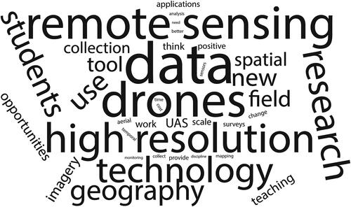
Summary statistics, primarily frequencies, and percentages were used to compile the demographic data and drone usage and experience information. The remaining open-ended responses were analyzed by question to draw out content themes stressed by the respondents (similar approach to Mathews and Wikle Citation2017). We also created a word cloud to provide a graphical summary of all open-ended responses where font size is proportional to word frequency. If the frequency of any word was less than ten, that word was removed.
Results
Quantitative Findings
Demographics of Respondents. Female geographers represented only one-third (33 percent) of the total drone users in this survey. The percentage of female drone geographers was 75 percent, however, at the youngest age group ranging from eighteen to twenty-four years of age. The percentage steadily decreased in older age groups, to 38 percent in the twenty-five-to-thirty-four range, 30 percent in the thirty-five-to forty-four range, 10 percent in the forty-five and older age group, and no female respondents in the older than sixty-five range (). Among female geographers, half of the respondents represented traditional and research faculty, and the other half were graduate students with wide-ranging expertise in geography (). Examples of expertise ranged from geographic techniques and physical geography (including geology and fluvial geomorphology) to human–environment interactions. The racial and ethnic diversity of drone geographers responding to this survey was highly skewed. Our study suggests that about 85 percent of geographers who use drones in research, instruction, or both identify as White and less than 1 percent identify as Black or African American (one female traditional faculty specializing in physical geography; ).
Figure 1 Demographics of survey respondents: (A) The gender distribution in drone geographers across the age groups showing the percentage of female drone geographers between eighteen and sixty-five and older age groups. (B) Gender distribution across job types with a higher number of female drone geographers as graduate students followed by the traditional and research faculty. (C) The distribution of racial and ethnic diversity across the age groups. (D) The majority of Asian and Black or African American drone geographers fall between twenty-five and forty-four years old and either are research faculty or graduate students.
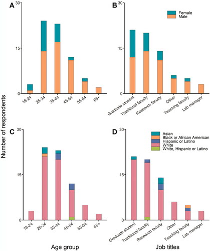
Traditional faculty and graduate students, almost equal in number, cumulatively constituted about 50 percent of the total population of survey respondents (). Asian and Hispanic geographers represented equal populations at about 5 percent each, with the majority (90 percent) being faculty members (i.e., instruction, research, or traditional faculty) and falling within the twenty-five-to-forty-four age group (). Survey data show low participation from minority racial and ethnic females (e.g., Asian, Hispanic, and Black or African American, 4 percent in each), contrary to the White female group, which constitutes about 84 percent of the overall participating female geographers. The male racial and ethnic diversity in drone geographers shows similar trends, with Asian and Hispanic male geographers representing 7 percent and about 6 percent of the total population, respectively, whereas White males constitute more than 87 percent with no representation from the Black or African American community (). The entire Asian and Hispanic male populations serve as teaching or research faculty compared to White male geographers, where about 26 percent are traditional faculty, 20 percent serve as teaching or research faculty, and about 22 percent are graduate students ().
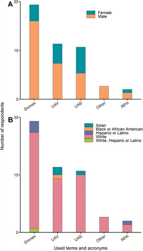
Summary Statistics of Responses. Although the word drone has a negative military-related connotation (Blitz et al. Citation2015; Schulzke Citation2017), many geographers (about 38 percent) prefer using this term, followed by unmanned aerial vehicle (UAV; about 21 percent) and unmanned aerial system (UAS; about 19 percent). Most female geographers (about 60 percent) preferred using UAS or UAV over drones (25 percent), and the rest exhibited no preference (). For ethnicity, about 38 percent of White geographers prefer drones over UAS or UAV (about 22 percent each; ). The rationale behind using these acronyms varies from easier to say or more easily recognizable, gender inclusivity (uncrewed, unpiloted, or unoccupied over unmanned), technical (UASs include sensors etc.),to country-specific regulation (piloted aircraft system and remotely piloted aircraft system are official terms in Spain and Australia, respectively). UAS is the commonly used term by the Federal Aviation Administration and other public agencies in the United States.
Figure 2 The use of drone acronyms by (A) gender and (B) among racial and ethnic geographers. Note: UAV = unmanned/unoccupied/uncrewed aerial vehicle; UAS = unmanned aerial systems; RPA = remotely piloted aircraft.
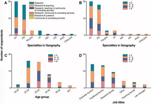
Approximately 40 percent of geographers exclusively use drones in research, followed by about 30 percent in both instruction and research, and the remainder in various activities that include outreach and community-based work (). Similar trends were observed in geographers’ area of specialty. For example, the expertise of 40 percent of drone users is in geographic techniques, followed by 22 percent in physical geography. Other expertise includes human geography and human–environment interactions in various proportions (). Only 22 percent of drone geographers have more than six years of experience, and more than 86 percent use it in research, which suggests its rapid growth and popularity among geographers (). The traditional and research faculty between thirty-five and fifty-four years old have more than six years of experience using drones in geographic techniques and physical geography for various activities. Additionally, only about 25 percent of geographers collect imagery or data twice or more per month. Many users collect imagery or data only once per month (about 25 percent), per semester (32 percent), or per academic year (about 6 percent), and ten respondents (about 12 percent) did not answer the question ().
Figure 3 The extent of drone use in various academic and nonacademic activities across (A) the specialties in geography discipline, (B) years of experience across the age groups, (C) the specialties in geography, and (D) across various positions. Note: GT = geographic techniques; PG = physical geography; PG-EHI = physical geography and human–environment interaction; Ot = other; HEI = human–environment interaction; HG = human geography; PHG = physical and human geography; PHG-EHI = physical and human geography and human–environment interaction.
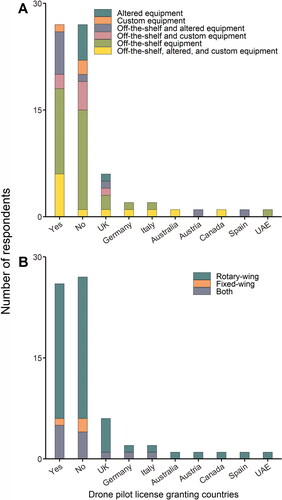
Only 54 percent of the total geographers carry a drone pilot license issued by the United States (36 percent) and United Kingdom (about 8 percent), including countries such as Spain, Germany, Italy, Canada, Australia, Austria, and the United Arab Emirates; 12 percent did not disclose this information (). Geographers predominantly use off-the-shelf drone systems (). Off-the-shelf and rotary-wing drones (i.e., >75 percent and about 68 percent, respectively) are the most desirable, perhaps due to their low cost and ease of use ().
Figure 4 Graphs, separated by country, showing that (A) most geographers in this sample use various versions of off-the-shelf drones and a smaller fraction of users rely on altered and customized drone equipment and (B) most geographers prefer to use rotary-wing or both rotary- and fixed-wing drone systems in research and teaching.
Qualitative Findings
In total, four open-ended survey prompts allowed respondents to answer freely without character limits. We summarized the responses by question in the sections that follow. Although these questions were intentionally crafted to address different topics and draw out different responses, similarities were apparent in responses in aggregate. For this reason, we found it necessary to summarize respondent answers. provides a graphical summary of all open-ended responses from the four questions where font size is proportional to word frequency. Not surprising, drone(s) and data were mentioned very frequently, as were remote sensing, high resolution, and technology. High resolution (e.g., spatial and temporal), in particular, and related but less mentioned topics of field (work), (data) collection, and tools were important throughout respondents’ answers. Research and students were frequently repeated, which attests to the importance of drone usage in both research and instruction for this sampled group.
Figure 5 Word cloud emphasizing the most frequent words input by survey respondents for all open-ended questions (minimum frequency of 10).
How Do Drones Positively, Negatively, or Otherwise Influence the Discipline of Geography? Respondents were overwhelmingly positive (92 percent of those answering this survey prompt; percentages shown hereafter were calculated this same way) regarding how drones influence the discipline of geography. As to why respondents were positive toward the technology, over half (51 percent) noted that drones provide unparalleled opportunities for geographers to obtain high temporal and spatial resolution data for local-scale analyses. The accessibility of drone technology due to low cost (including integrated or add-on imaging sensors) and relative ease of use were stressed by many survey respondents (39 percent). One even stated that drones have “democratized remote sensing,” and others echoed this by noting how drones facilitate data collection by more diverse users (e.g., indigenous communities, citizen scientists).
From the faculty perspective, several respondents (8 percent) articulated that drones possess a “cool factor” that attracts students (from a variety of majors) to geography courses and programs and provide a way to revive or revitalize photogrammetry within geography. Several respondents (10 percent) stated that drones enable geographers to get into the field and engage local communities in both research and instruction capacities. In remote sensing courses, drones were seen by respondents as supportive of learning course concepts with hands-on learning, fieldwork, and applied problem solving. Additionally, drones enable students to conduct remote sensing projects from start (planning and data collection) to finish (data processing and analysis in the lab), unlike what is possible with satellite imagery. Exposing geography to nongeographers using drones goes beyond students, though, including as a bridge between disciplines and across campuses, with the potential to improve geography’s standing as a discipline. Respondents further highlighted how drone-collected data with very high spatial resolution for small geographic extents have shifted thinking about the scale at which we administer analyses. Drones are a “technology that encourages local scale geographic inquiry and community engaged research through its low-cost, ease of use, and high-resolution geospatial data products.” Other respondents noted that drones provide unique opportunities for geographers to better share what they do by way of outreach and public engagement (e.g., community-based mapping, collaborations with local partners).
Some respondents noted negative aspects of drone adoption in geography. In an era of big data, drones provide “too much data, and not enough time to research everything” and enable “the fetishization of overly precise data.” Others noted potential misuse of drones (i.e., operating without adhering to civil aviation regulations) and ethical issues associated with such high spatial resolution imagery (and other data). Although the “cool factor” that drones possess is typically considered a positive, the flip side is that researchers might be too interested in using drones without having a research question (i.e., drones are a tool for problem solving). Further, some respondents emphasized a need for geographers to standardize terminology (e.g., drone vs. UAS vs. remotely piloted aircraft system; Structure from Motion vs. photogrammetry, etc.) and approaches with drone technology to improve communication across the discipline.
How Has Drone Technology Changed the Work That You Do? Many respondents (25 percent) stressed how drone technology has changed what and how they teach. Specifically, these respondents noted altering geospatial coursework to incorporate elements of what drones offer geographers, but some mentioned creation of new drone-focused remote sensing courses (or revival of previous photogrammetry courses). Respondents emphasized that drones could support active pedagogical approaches (e.g., problem-based learning) as tools for data collection and instruments that encourage field work. Students were beneficiaries of this new opportunity because drone technology has altered geospatial professions and students need to have working knowledge of surveying, image capture, and other field-based skills. Others saw drones as a unique tool to link students (and researchers) to the local community, enabling citizen science and outreach.
In terms of research, 38 percent of respondents stressed the novelty of drone data—for example, very high-resolution imagery, three-dimensional point clouds, and the ability to repeatedly capture data (all at a relatively low cost)—and its impact on their work. Due to this, drones were seen by respondents to enable the development of new research questions at unprecedented spatial scales. Others emphasized the importance of comparing or fusing drone data with traditional data sets to better address research questions (6 percent). Drones were further described by respondents (6 percent) as vehicles for collaboration across campuses (e.g., for multi- and interdisciplinary research).
What Future Opportunities Do Drones Present to Geographers and the Discipline of Geography? Most broadly, in answering this prompt about how drones influence geographers and the discipline of geography, survey respondents made clear the importance of the discipline to this emerging area of focus in research and instruction. Some respondents (7 percent) specifically stressed the importance of geographers (with their knowledge of photogrammetry, remote sensing, and GIS) assuming and maintaining a leadership role on campuses in the area of drones for mapping:
Drones are underpinned by geospatial technology, and we need to firmly claim expertise in this area. They are valuable tools for observing and making measurements of the environment, and it’s important to demonstrate the huge potential for using drones to capture information that allows us to better monitor and manage our local ecosystems.
Drones provide a new area of specialization and professionalization within geography and provide a great opportunity for academic geography departments and programs to prepare their students for careers.
Regarding scholarship, half of the respondents (50 percent) indicated that drones provide geographers a new ability to address research questions that might not have been possible prior to use of the technology. One respondent in particular (although others reflected this sentiment) contrasted drone-captured data and traditional data in terms of how they influence questions geographers can ask:
More data collected that is directly relevant and/or tailored to the vein of scientific inquiry, as opposed to using whatever satellite data is available and tailoring the scientific questions to that (e.g., 30-m pixels might mean studying ecology over a larger spatial extent, whereas UAS data could enable ecological studies that include specific plant individuals).
In other words, and paraphrased from a different respondent, drones enable the measurement of things that we cannot measure in other ways (i.e., fill a vertical sensor gap between piloted aircraft and ground-based observations).
In terms of instruction, several respondents (11 percent) noted how drone-based remote sensing is much less abstract to students compared with other forms (e.g., satellite) and improves the ability of instructors to teach remote sensing content.
I think one way is that remote sensing has always seemed inaccessible in that instruments are massively expensive things you never see. The ability to capture super high-res[olution] images for a class that can then be used to talk about remote-sensing concepts opens some doors for some people, making the production pipeline easier to see.
Further, hands-on demonstrations of drones for geospatial data collection and creation can be carried out quickly (i.e., in a single class period), making it practical for instructors to adopt in courses. Importantly, students benefit from learning about these technologies because they are an increasingly important tool within the geospatial profession. Due to the nature of this question, respondents also described many potential future advancements in the realm of drone technology that might affect geography and geographers. These included fully autonomous drones with automatic repeat data collection, swarming ability with multiple drones for coordinated larger area data collection and sampling, moving toward real-time data analysis and continuous monitoring of Earth surface features and processes, improved sensors for higher quality imagery and integration of multiple data types (i.e., hyperspectral imagery, light detection and ranging), and improved battery life for longer flight times. There is no question that these technologies are advancing rapidly, and respondents showed how they are ready to incorporate such changes into their work.
Do You Think Students Should Be Exposed to Using Drones in Geography? Overwhelmingly, respondents answered yes to this question (98 percent). For example:
Absolutely. It is a new and rapidly growing technology that will only become more integrated with the study of geography and geosciences; much like collecting GPS [Global Positioning System] data and using GIS was twenty-ish years ago.
As for why, many again alluded to the importance of hands-on learning (i.e., problem-based learning) for students and practical career preparation (i.e., drones as another tool in the geographer’s toolkit). One stated that “the technology can be applied in all realms of geographic inquiry, then it is a skill set that all contemporary geography students should be exposed to.”
Not surprising given the history of the discipline, a respondent noted that “geography has a bit of an identity crisis” but that “drones can help change perceptions in this space.” Others reflected that ignoring such a technology would be detrimental to the advancement of the discipline and its students. Even if geographers find a new technology like this problematic, “geographers must engage with technology to effectively critique it” and compare new data and data sources to more traditional ones. It is important to note that respondents across the four open-ended prompts mentioned the risks of operating drone technology (e.g., safe and legal flying, ethics of data collection and usage, etc.) as well as the issues related to data ethics when obtaining such higher spatial resolution information from drone platforms.
Discussion
Quantitative results of this study show a trend in female involvement in the younger age categories, with females representing about 75 percent of the eighteen-to-twenty-four age category. This might coincide with the general trends of (1) high enrollments of female graduate students in the field of geography at universities in the United States (46 percent in 2018; Schurr, Müller, and Imhof Citation2020) or (2) more females joining science, technology, engineering, and mathematics (STEM) fields, with an increase from 8 percent in 1970 to 27 percent in 2019 (Martinez and Christnacht Citation2021). Females are still vastly underrepresented in the STEM workforce, however, as are ethnic and racial minorities (Estrada, Hernandez, and Schultz Citation2018). The lack of responses from females and ethnic and racial minorities in this survey might reflect these statistics, although there is the possibility that our target audience was not broad enough. Additionally, we had limited participation from the age category of those sixty-five and over (two men and no women) and the eighteen-to-twenty-four age category (one man and three women). For the older category, this could be an artifact of the online survey, which older cohorts might not be as comfortable with. Recent research, however, shows that those who avoid Web-based surveys are predominantly female and retired and report a lower level of education (Kelfve et al. Citation2020). Because we targeted geography departments in institutions of higher learning, we did not target retirees, nor were we targeting those with lower levels of education. Thus, the online survey did not affect the participants. The results showing 75 percent female participation in the youngest age group give us much hope and encouragement for the future of geography. Indeed, drones might have the power to democratize geographic data collection methodologies by drawing more diverse populations to the field, improving gender and ethnicity gaps, and thus allowing geographers to address some of the social implications of technology; that is, broadening participation outside of traditional academic demographics and increasing access to geographic information (Harris and Weiner Citation1996). With the inclusive SheMaps work of Joyce, Bartolo, Michael, and Anderson (Citation2020) and Joyce, Bartolo, and Anderson (Citation2020) and a new open access drone data-sharing platform, GeoNadir (Citation2021), we are hopeful that the trend of more females and diverse populations using drones will continue.
The bulk of survey respondents in the qualitative section of the survey expressed a need for geography as a discipline to better conceptualize the inclusion of drones into geographic research and instruction. Over the last two decades, drone adoption by geographers has increased dramatically, especially in geographic research (Singh and Frazier Citation2018; Fagin, Wikle, and Mathews Citation2020). Over the same time, however, little in the way of conceptual work has been published. Due to the excitement that these tools offer unprecedented spatial and temporal resolution data for geographic analyses, most research to date has been application oriented. In terms of research, Lippitt and Zhang (Citation2018) provided a strong conceptualization of drones within remote sensing that could be applied more broadly to geography. Similarly, Frazier et al. (Citation2017) conceptualized drone adoption at the intersection of GIScience and meteorology. These works, though, remain focused on subfields of the discipline. Garrett and Anderson (Citation2018) emphasized that both physical and human geographers (i.e., geography as a whole) should be involved in integrating drones within the discipline by researching the many critical components of geography (e.g., data ethics and political and legal avenues of airspace access, data access, democratization of knowledge production, etc.). In fact, drones have the capability of improving geographic research by (1) investigating questions that would otherwise go unanswered due to the need for frequent and very high-resolution imagery, which drones can facilitate; (2) democratizing data access and data production, allowing geography departments with minimal funding to sustain their research programs by investing relatively small amounts into drone equipment; (3) the integration of more diverse populations into the knowledge production process; and (4) enhancing collaborations with communities and citizen scientists on a new level through participatory processes.
Pertaining to geographical knowledge production and data creation, geographers should find a balance between data collection frequency and quality. Many off-the-shelf drones are equipped with high-resolution sensors, which have the capability of collecting subcentimeter imagery and can quickly fill up memory cards and other storage devices. Although the data collected can be very high-resolution, for some applications like large-area terrain mapping, precision agriculture, and land cover classifications, coarser resolution data are preferable for ease of use and processing times (Rogers, Manning, and Livingstone Citation2020). Another potential deterrent in the frequent collection of drone imagery is the equipment maintenance and the procedures required in preparing drones for fieldwork, including requesting flight permissions from private property owners. These could be reasons why only 25 percent of respondents to this survey indicated that they collect drone imagery twice or more per month, whereas the remaining respondents collect data less frequently: once per month (25 percent), once per semester (32 percent), or once per academic year (6 percent). If users are not conducting active research, training, or teaching students, the time and storage costs associated with drone data collection might not merit frequent flights. One respondent highlighted that drones, although currently jumbled in rules, regulations, and many applications, create “more data, more chaos, but more excitement” and are good for geography—a common sentiment of many drone users.
It is evident from the results of this study that geography still faces challenges in integrating drones into higher education instruction and curriculum, because the latter is often difficult to change. It could take months or years to add new courses, depending on the department, university, or college. Nevertheless, several efforts have made headway in developing course content (Jeziorska Citation2014; Al-Tahir Citation2015; Teo et al. Citation2016; Cliffe Citation2019), but due to the amount of time required to cover important issues such as regulations, licensing, insurance, and use and maintenance of equipment, eventually leading to “how to fly a drone and collect data” (without even taking into consideration the more conceptual research applications of drones), one typical undergraduate introductory course is inadequate. Geography departments should work to develop a plethora of drone-related courses or new drone-based programs, which would breathe new life into stagnant departments and ameliorate the recent trends of decline (Kaplan Citation2019). Survey respondents communicated the importance of drones in geography as a tool that can draw students into geography course work (Stoler et al. Citation2021) and help to improve the visibility of geography as a whole on and off campus. Clearly, drones are seen as a positive for the discipline, as confirmed by surveying geography department and program chairs and directors in the United States and Canada (Fagin, Wikle, and Mathews Citation2020). Parallels can be drawn between drones today and previous technologies (e.g., GPS, GIS, etc.) that helped to shape today’s academic geography. GIS has arguably been considered an important catalyst for reinvigorating the discipline (Openshaw Citation1991; Abler Citation1993; Longley Citation2000). The “cool factor” of drones might be helpful in filling geography courses, encouraging students to declare geography majors, and leading them to consider graduate degrees in geography.
Ways Forward
Our data suggest that this small sample of geographers, who are predominantly American, although sprinkled with international respondents, has recognized the potential of drones to enhance their approach to research and instruction. From these results we see that drones have the capability of attracting a younger, more diverse group of geographers and offer the potential to democratize geographic data collection and data access. Although various terms are used across geography to refer to this technology, it is important that the terms we use are inclusive and acceptable to the entire discipline. Given our results, we suggest using drone, which is easy to conceptualize, or unoccupied aircraft system, which is inclusive. Geographers should also find a balance between data collection frequency, spatial resolution, and quality to better answer geographic questions and advance the conceptualization of drones in geography rather than feel suffocated by digital data. Likewise, geography departments might benefit from establishing a unified system that guides equipment maintenance and oversees procedures required in preparing drones for fieldwork, including requesting flight permissions from private property owners.
Although it is difficult to determine trends from such a small sample size, the increase in female participation among younger age groups gives us hope and encouragement for the future of geography, because drones might have the power to improve gender and ethnicity gaps with exciting resources to draw diverse populations to the field. Because the theory and conceptualization of drone data collection lie within the foundations of geography, there is hope that with more interest in drones and aerial image processing, students will take an interest in remote sensing and GIScience. In turn, this might eventually assist in improving visibility of the field and bringing more students to geography. At a minimum, drones are a powerful tool, and the data presented here suggest that they have the potential to democratize the data collection process by including users who might not have previously had a voice in the data collection or analysis processes.
Acknowledgments
First, the authors thank Ruby Rhys Rogers Williams for her timely entry into the world on the day this article was accepted; may she be a future geographer and drone user! Additionally, we thank all respondents for completing the Web-based survey, many of whom were quoted (with their express permission) in the text. Our protocol and survey instrument were approved by the Auburn University Institutional Review Board on 22 September 2020 (Protocol #20-423 EX 2009). We thank the three anonymous reviewers, whose comments and feedback made our article stronger. Further, we acknowledge our many colleagues in the American Association of Geographers (AAG) who have contributed to the UAS Symposia over the last several years (Read, Ricker, Frazier, and many more) as well as the AAG itself for supporting these efforts at its annual meetings. The symposia series over the years has spurred many important conversations about drones within geography that directly led to a special issue in Drones and subsequently to this collaborative effort.
Additional information
Notes on contributors
Stephanie R. Rogers
STEPHANIE R. ROGERS is an Assistant Professor in the Department of Geosciences at Auburn University, Auburn, AL 36849. E-mail: [email protected]. Her research addresses the development and application of geospatial technologies from a GIScience perspective across multiple disciplines while considering both the physical and human drivers of environmental issues.
Kunwar K. Singh
KUNWAR K. SINGH is a Geospatial Scientist at AidData and an Affiliate Faculty at the Center for Geospatial Analysis at William & Mary, Williamsburg, VA 23185. E-mail: [email protected]. His research focuses on land and vegetation dynamics and their impacts on natural resources.
Adam J. Mathews
ADAM J. MATHEWS is an Associate Professor in the Department of Geography, Environment, and Tourism at Western Michigan University, Kalamazoo, MI 49008. E-mail: [email protected]. His research interests include GIS and remote sensing applications such as use of drone-based SfM and LiDAR to study urban environments and vegetation canopy as well as GIS education.
Anthony R. Cummings
ANTHONY R. CUMMINGS is an Associate Professor in the Geospatial Information Sciences program in the School of Economic, Political and Policy Sciences at the University of Texas at Dallas, Richardson, TX 75080. E-mail: [email protected]. His research interests include human–natural environment interactions and remote sensing using drone-derived data.
Literature Cited
- Abler, R. F. 1993. Everything in its place: GPS, GIS, and geography in the 1990s. The Professional Geographer 45 (2):131–39. doi: https://doi.org/10.1111/j.0033-0124.1993.00131.x.
- Al-Tahir, R. 2015. Integrating UAV into geomatics curriculum. The International Archives of the Photogrammetry, Remote Sensing and Spatial Information Sciences, XL-1-W4, 387–90. doi: https://doi.org/10.5194/isprsarchives-XL-1-W4-387-2015.
- Blitz, M. J., J. Grimsley, S. E. Henderson, and J. Thai. 2015. Regulating drones under the first and Fourth Amendments. William & Mary Law Review 57: 49.
- Brandt, K., L. Graham, T. Hawthorne, J. Jeanty, B. Burkholder, C. Munisteri, and C. Visaggi. 2020. Integrating sketch mapping and hot spot analysis to enhance capacity for community-level flood and disaster risk management. The Geographical Journal 186 (2):198–212. doi: https://doi.org/10.1111/geoj.12330.
- Carrivick, J. L., M. W. Smith, and D. J. Quincey. 2016. Structure from motion in the geosciences. Hoboken, NJ: Wiley.
- Cliffe, A. D. 2019. Evaluating the introduction of unmanned aerial vehicles for teaching and learning in geoscience fieldwork education. Journal of Geography in Higher Education 43 (4):582–98. doi: https://doi.org/10.1080/03098265.2019.1655718.
- Cummings, A. R., G. R. Cummings, E. Hamer, P. Moses, Z. Norman, V. Captain, R. Bento, and K. Butler. 2017. Developing a UAV-based monitoring program with indigenous peoples. Journal of Unmanned Vehicle Systems 5 (4):115–25. doi: https://doi.org/10.1139/juvs-2016-0022.
- Dandois, J. P., and E. C. Ellis. 2013. High spatial resolution three-dimensional mapping of vegetation spectral dynamics using computer vision. Remote Sensing of Environment 136:259–76. doi: https://doi.org/10.1016/j.rse.2013.04.005.
- Enemark, C. 2013. Armed drones and the ethics of war: Military virtue in a post-heroic age. London and New York: Routledge.
- Estrada, M., P. R. Hernandez, and P. W. Schultz. 2018. A longitudinal study of how quality mentorship and research experience integrate underrepresented minorities into STEM careers. CBE—Life Sciences Education 17 (1):ar9. doi: https://doi.org/10.1187/cbe.17-04-0066.
- Fagin, T. D., T. A. Wikle, and A. J. Mathews. 2020. Emerging geospatial technologies in instruction and research: An assessment of U.S. and Canadian geography departments and programs. The Professional Geographer 72 (4):631–43. doi: https://doi.org/10.1080/00330124.2020.1777573.
- Fonstad, M. A., J. T. Dietrich, B. C. Courville, J. L. Jensen, and P. E. Carbonneau. 2013. Topographic structure from motion: A new development in photogrammetric measurement. Earth Surface Processes and Landforms 38 (4):421–30. doi: https://doi.org/10.1002/esp.3366.
- Frazier, A. E., A. J. Mathews, B. L. Hemingway, C. Crick, E. Martin, and S. W. Smith. 2017. Integrating small unmanned air-craft systems (SUAS) into meteorology and atmospheric science: Challenges and opportunities for GIScience. GI_Forum 2017 (2):189–99. doi: https://doi.org/10.1553/giscience2017_02_s189.
- Garrett, B., and K. Anderson. 2018. Drone methodologies: Taking flight in human and physical geography. Transactions of the Institute of British Geographers 43 (3):341–59. doi: https://doi.org/10.1111/tran.12232.
- GeoNadir. 2021. Help protect the world’s most at-risk ecosystems. Accessed July 14, 2021. https://www.geonadir.com/?r_done=1.
- Goodchild, M. F. 2018. Reimagining the history of GIS. Annals of GIS 24 (1):1–8. doi: https://doi.org/10.1080/19475683.2018.1424737.
- Harris, T. M., and D. Weiner. 1996. GIS and society: The social implications of how people, space, and environment are represented in GIS. Summary Report, National Center of Geographic Information and Analysis. Ithaca, NY: UCGIS.
- Hawthorne, T. L., and O. S. Jarrett. 2018. Developing the next generation of community-based scholars. The Professional Geographer 70 (2):291–97. doi: https://doi.org/10.1080/00330124.2017.1366780.
- Hemingway, B. L., A. E. Frazier, B. R. Elbing, and J. D. Jacob. 2017. Vertical sampling scales for atmospheric boundary layer measurements from small unmanned aircraft systems (SUAS). Atmosphere 8 (12):176. doi: https://doi.org/10.3390/atmos8090176.
- James, P. E. 1972. All possible worlds: A history of geographical ideas. Indianapolis, IN: Odyssey Press.
- Jensen, J. R. 2017. Drone aerial photography and videography: Data collection and image interpretation. ebook.
- Jeziorska, J. 2014. Unmanned aerial vehicle—A tool for acquiring spatial data for research and commercial purposes. New course in the geography and cartography curriculum in higher education. The International Archives of the Photogrammetry, Remote Sensing and Spatial Information Sciences, XL‐6, 37–42. doi: https://doi.org/10.5194/isprsarchives-XL-6-37-2014.
- Joyce, K. E., R. Bartolo, and K. Anderson. 2020. Drones special issue. She Maps. https://www.mdpi.com/journal/drones/special_issues/shemaps_drones#info.
- Joyce, K. E., R. Bartolo, S. Michael, and K. Anderson. 2020. Remote sensing special issue. She Maps. https://www.mdpi.com/journal/remotesensing/special_issues/shemaps.
- Joyce, K. E., N. Meiklejohn, and P. C. H. Mead. 2020. Using minidrones to teach geospatial technology fundamentals. Drones 4 (3):57. doi: https://doi.org/10.3390/drones4030057.
- Kaplan, D. H. 2019. Should we be worried? Or how to maintain and expand the number of geographers in our schools. AAG Newsletter. http://news.aag.org/2019/07/should-we-be-worried/. Accessed July 15, 2021. doi: https://doi.org/10.14433/2017.0056.
- Kelfve, S., M. Kivi, B. Johansson, and M. Lindwall. 2020. Going web or staying paper? The use of web-surveys among older people. BMC Medical Research Methodology 20 (1):1–12. doi: https://doi.org/10.1186/s12874-020-01138-0.
- Kelley, K., B. Clark, V. Brown, and J. Sitzia. 2003. Good practice in the conduct and reporting of survey research. International Journal for Quality in Health Care: Journal of the International Society for Quality in Health Care 15 (3):261–66. doi: https://doi.org/10.1093/intqhc/mzg031.
- Lippitt, C. D., and S. Zhang. 2018. The impact of small unmanned airborne platforms on passive optical remote sensing: A conceptual perspective. International Journal of Remote Sensing 39 (15–16):4852–68. doi: https://doi.org/10.1080/01431161.2018.1490504.
- Longley, P. A. 2000. The academic success of GIS in geography: Problems and prospects. Journal of Geographical Systems 2 (1):37–42. doi: https://doi.org/10.1007/s101090050027.
- Martinez, A., and C. Christnacht. 2021. Women making gains in STEM occupations but still underrepresented. https://www.census.gov/library/stories/2021/01/women-making-gains-in-stem-occupations-but-still-underrepresented.html.
- Mathews, A. J., and A. E. Frazier. 2017. Unmanned aerial systems. The geographic information science & technology body of knowledge. 2nd quarter, 2017 ed. Ithaca: UCGIS. http://Gistbok.Ucgis.Org/Bok-Topics/Unmanned-Aerial-Systems-Uas.
- Mathews, A. J., and T. A. Wikle. 2017. Assessing professional benefits of GIS certification. Cartography and Geographic Information Science 44 (5):452–62. doi: https://doi.org/10.1080/15230406.2016.1185742.
- Openshaw, S. 1991. A view on the GIS crisis in geography, or, using GIS to put Humpty-Dumpty back together again. Environment and Planning A: Economy and Space 23 (5):621–28. doi: https://doi.org/10.1068/a230621.
- Paneque-Gálvez, J., N. Vargas-Ramírez, B. M. Napoletano, and A. Cummings. 2017. Grassroots innovation using drones for indigenous mapping and monitoring. Land 6 (4):86. doi: https://doi.org/10.3390/land6040086.
- Rogers, S. R., I. Manning, and W. Livingstone. 2020. Comparing the spatial accuracy of digital surface models from four unoccupied aerial systems: Photogrammetry versus LiDAR. Remote Sensing 12 (17):2806. doi: https://doi.org/10.3390/rs12172806.
- Schoepfer, I., and S. R. Rogers. 2014. A new qualitative GIS method for investigating neighbourhood characteristics using a tablet. Cartographica: The International Journal for Geographic Information and Geovisualization 49 (2):127–43. doi: https://doi.org/10.3138/carto.49.2.1810.
- Schulzke, M. 2017. The drone revolution. In The morality of drone warfare and the politics of regulation, 27–53. London: Palgrave Macmillan.
- Schurr, C., M. Müller, and N. Imhof. 2020. Who makes geographical knowledge? The gender of geography’s gatekeepers. The Professional Geographer 72 (3):317–31. doi: https://doi.org/10.1080/00330124.2020.1744169.
- Schuurman, N. 2000. Trouble in the heartland: GIS and its critics in the 1990s. Progress in Human Geography 24 (4):569–90. doi: https://doi.org/10.1191/030913200100189111.
- Sheppard, E. 2005. Knowledge production through critical GIS: Genealogy and prospects. Cartographica: The International Journal for Geographic Information and Geovisualization 40 (4):5–21. doi: https://doi.org/10.3138/GH27-1847-QP71-7TP7.
- Singh, K. K., and A. E. Frazier. 2018. A meta-analysis and review of unmanned aircraft system (UAS) imagery for terrestrial applications. International Journal of Remote Sensing 39 (15–16):5078–98. doi: https://doi.org/10.1080/01431161.2017.1420941.
- Snavely, N., S. M. Seitz, and R. Szeliski. 2008. Modeling the world from Internet photo collections. International Journal of Computer Vision 80 (2):189–210. doi: https://doi.org/10.1007/s11263-007-0107-3.
- Stoler, J., D. Ter-Ghazaryan, I. Sheskin, A. L. Pearson, G. Schnakenberg, D. Cagalanan, K. Swanson, and P. Jankowski. 2021. What’s in a name? Undergraduate student perceptions of geography, environment, and sustainability key words and program names. Annals of the American Association of Geographers 111 (2):317–42. doi: https://doi.org/10.1080/24694452.2020.1766412.
- Talen, E. 1999. Constructing neighborhoods from the bottom up: The case for resident-generated GIS. Environment and Planning B: Planning and Design 26 (4):533–54. doi: https://doi.org/10.1068/b260533.
- Teo, T.-A., P. T.-Y. Shih, S.-C. Yu, and F. Tsai. 2016. The use of UAS for rapid 3D mapping in geomatics education. The International Archives of the Photogrammetry, Remote Sensing and Spatial Information Sciences, XLI-B6, 95–100. doi: https://doi.org/10.5194/isprs-archives-XLI-B6-95-2016.
- Tomlinson, R. F. 1970. Environment information systems: The proceedings of the UNESCO/IGU First Symposium on Geographical Information Systems. Ottawa, Canada: International Geographical Union Commission on Geographical Data Sensing.
- van der Schee, J., H. Trimp, T. Béneker, and T. Favier. 2015. Digital geography education in the twenty-first century: Needs and opportunities. In Geospatial technologies and geography education in a changing world, ed. O. Muñiz Solari, A. Demirci, and J. van der Schee, 11–20. Tokyo: Springer.
- Wilbanks, T. J. 2004. Geography and technology. In Geography and technology, ed. S. D. Brunn, S. L. Cutter, and J. W. Harrington Jr., 3–16. Dordrecht, The Netherlands: Springer.
- Yang, B., T. L. Hawthorne, M. Hessing-Lewis, E. J. Duffy, L. Y. Reshitnyk, M. Feinman, and H. Searson. 2020. Developing an introductory UAV/drone mapping training program for seagrass monitoring and research. Drones 4 (4):70. doi: https://doi.org/10.3390/drones4040070.