
Abstract
GIScience is essential to geography education. Different curriculums and textbooks have been developed to teach GIScience in classrooms through lectures and exercises corresponding to the educational situation of each country. We developed e-learning materials based on existing research outcomes for GIScience education in Japan, such as the Japanese GIS core curriculum for university education. Using the materials, we held a three-day intensive GIScience class at the University of Tokyo from 2018 to 2022 with questionnaire surveys to investigate the educational effects of the materials and factors influencing GIScience learning. The attending students browsed the materials and studied GIScience by themselves but asked questions of teachers if necessary. The questionnaire survey results indicate that most students felt geospatial data processing is somewhat complex, but they were satisfied with the opportunity of GIScience learning. Whether the students thought the exercise was simple and easy depended on their confidence in computer knowledge and operation and their preferred learning style at their own pace. The students’ satisfaction level and ease in using the material correlate with their motivation level, the number of questions they asked the others, and their preferred style for learning at their own pace.
GIScience education at the university level is essential to foster students’ knowledge of geography and related fields. The use of geographic information systems (GIS) and associated technologies has become widespread in modern society (Fagin, Wikle, and Mathews Citation2020). Furthermore, enhancing GIScience education is crucial based on employer demand and teaching supply (Rip, Wallentin, and Van Lammeren Citation2014; Lukinbeal and Monk Citation2015).
In the early 1990s, the consideration of teaching GIScience began to gain traction in the United States. Researchers from the National Center for Geographic Information and Analysis (NCGIA) developed a GIS core curriculum (Kemp and Goodchild Citation1991). Subsequently, the University Consortium for Geographic Information Science (UCGIS) in the United States also published the Geographic Information Science and Technology Body of Knowledge (GIS & T BoK) in 2006 (DiBiase et al. Citation2006; Tate and Unwin Citation2009). The BoK (see http://gistbok.ucgis.org/) is widely recognized as the primary reference for geospatial curriculum design (Wallentin, Hofer, and Traun Citation2015). In 2016, the UCGIS initiated the revision of the BoK, focusing on sections related to GIScience education (UCGIS Citation2024) and presenting the material as a Web page for a broader audience.
In contrast, initial discussions about GIScience education in Japan began a decade later than in Western developed countries. From 2002 to 2008, Japanese geography researchers developed an original GIS core curriculum specifically for domestic GIScience education (Kawabata et al. Citation2005; Okabe Citation2006). During this period, many Japanese universities introduced lectures and exercise classes to teach GIScience more effectively; however, it was noted that Japanese universities did not provide sufficient GIScience education in terms of quality and quantity (Sasaki et al. Citation2008). Based on the developed core curriculum, they needed to consider and propose ways to enhance GIScience education. Therefore, Japanese researchers launched several projects to improve GIScience lectures and exercise education. To strengthen these lectures, they developed educational materials such as the “Geographic Information Science Body of Knowledge” (Sadahiro et al. Citation2012) and a textbook entitled Geographic Information Science: GIS Standards (Asami et al. Citation2015).
GIScience education requires a delicate balance between theoretical lectures and practical exercises using software (Ooms et al. Citation2015). Although attempts were made to develop GIScience exercise materials in Japanese (Takahashi and Okabe Citation2008), these materials were neither widely distributed nor well recognized due to the mandatory use of commercial GIS software. This could pose a financial burden for many Japanese universities, except for those major institutions already implementing GIScience education. According to a survey by Sasaki et al. (Citation2008), the utilization rate of commercial software was higher than that of free software. In recent years, however, various high‐powered free GIS software packages, including Free and Open Source Software for Geospatial (FOSS4G) products, have been released online. Users can learn how to use GIS tools free of charge. Given these technological changes, it is crucial to consider GIScience education incorporating free GIS software. In the Japanese context, it is noteworthy that several introductory textbooks explaining how to use FOSS4G tools have been published since the 2010s. Nonetheless, there remains a gap in the availability of comprehensive educational materials that systematically provide instruction on the operation of free GIS aligned with the Japanese university-level GIScience curriculum.
Since 2015, we have undertaken a project to develop e-learning materials that elucidate various geospatial data processing techniques related to the Japanese GIS core curriculum, using free GIS software for Japanese university students (Yamauchi et al. Citation2019). The materials were designed to be used in university GIScience teaching classes and for self-learning by students, enabling them to learn geospatial data processing without incurring any costs. We undertook five GIScience exercise classes during regular semester classes at the university and conducted questionnaire surveys to verify the effectiveness and usefulness of the materials. This article presents the development process of the materials, their efficacy, and the essential factors for conducting practical GIScience exercises using the materials.
Methods
In this section, we introduce how to develop educational materials, topics for learning, course design, participants, and the questionnaire survey.
Design of the Educational Materials
Practical experience using GIS software and related skills are crucial for university students. Some researchers have developed online materials and courses (e.g., Ooms et al. Citation2015; Mui et al. Citation2015; Argles Citation2017; Vojteková et al. Citation2021) to provide practical experience. In such courses, researchers and educators have implemented various e-learning materials in HTML, PDF, and video formats. If educational materials are published online free of charge, users can learn about GIScience at any time. By using a free online platform, instructors can efficiently update their materials to reflect the latest information. Therefore, we decided to develop our materials as a freely accessible online application. The explanations consisted of text and captured images of software operations with the Markdown method, a lightweight markup language, to describe the contents.
The software was selected according to the type of data processing. Using FOSS4G tools and data sets to explain spatial data processing, users can start learning GIScience at low cost without needing additional licenses (Ciolli et al. Citation2017). We mainly used QGIS (QGIS Project Citation2024), which is known for its user-friendly graphical user interface (Marra et al. Citation2017; Sandhya Citation2020). Furthermore, it is considered one of the best GIS software packages for education due to its easy accessibility and availability free of charge (Novo et al. Citation2022). Many scientific manuscripts, including articles, conference papers, and books, have used QGIS as their primary GIS tool worldwide (Rosas-Chavoya et al. Citation2022). A similar situation can be observed in Japan, where approximately ten textbooks introducing geospatial data processing with QGIS for beginners have been published since the 2010s (e.g., Imaki Citation2013; Hashimoto Citation2015; Aoki Citation2023).
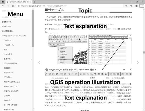
The described Markdown files were converted into an online book interface using the Honkit library (see https://github.com/honkit/honkit), a free tool (). The developed materials were titled GIS Open Educational Resources and released via GitHub (see https://github.com/). Additionally, they were licensed under the Creative Commons BY-NC-SA 4.0 license, which allows users to read and use the materials in various situations, such as downloading, redistributing to students, and editing, including additions and modifications of explanations, except for commercial use.
Figure 1 Example of the materials (see https://gis-oer.github.io/gitbook/book/index.html).
Structuring Learning Topics within the Materials
The learning topics were developed based on Geographic Information Science: GIS Standards edited by Asami et al. (Citation2015). This textbook allows for the systematic education of GIScience for undergraduate and graduate students in the geography department. The textbook comprises thirty chapters, aligning with the typical structure of Japanese university curricula, which consists of thirty class hours in an academic year. This textbook was primarily designed for use in lecture-based classes, as it includes teaching topics that do not require practical software-based lessons, such as the introduction to GIScience (Chapter 1), the history of GIS and GIScience (Chapter 2), and GIS and future society (Chapter 30). Consequently, we selected relevant chapters (Chapters 6–23, 26) to develop exercise materials (). Once these topics were organized, they were categorized into four courses—entry, beginner, expert, and extra—based on the difficulty for the students to learn.
Table 1 Course category and exercise sections of the materials
The entry course (A1) explains basic GIS software operations such as importing spatial data, opening an attribute table, and creating a map layout. The beginner course (B1–B12) explains fundamental spatial analysis methods using vector and raster data. This course also covers techniques for downloading data from Web pages and creating data within GIS. The expert course (C1–C5) deals with more advanced statistical spatial analysis, such as spatial autocorrelation and interpolation.
Based on the increasing use of geospatial data and technology in modern society (Fagin, Wikle, and Mathews Citation2020), we developed an additional course (D1–D5) to cover field surveys using equipment such as UAVs (unmanned aerial vehicles), creating 3D terrain models using 3D printers, implementing virtual reality applications using 3D geospatial data, developing online maps using WebGIS libraries, and processing data with Python.
Design of the Short-Term Course for Undergraduates
We have conducted GIScience teaching classes five times in the Department of Earth and Planetary Science at the University of Tokyo, from 2018 to 2022. Each class consisted of three days of intensive lectures and software exercises. The classes were offered for third-year students majoring in this department and designed in two parts: a two- to three-hour lecture and a five-hour practice. From 2018 to 2020, classes were held on campus, with each student operating a computer installed with QGIS. Students who preferred to use their laptops were permitted. In 2021 and 2022, due to COVID-19, we conducted the classes online using the Zoom application (see https://explore.zoom.us/). In 2018 and 2019, students used QGIS version 2.8 LTR, whereas in the 2020 to 2022 classes, they used QGIS version 3.4 LTR.
During the lecture portion of the course, we covered fundamental GIS concepts, GIScience theories, and various spatial analysis techniques. In the exercise portion, students practiced data processing related to those topics covered in the lectures. Before each exercise portion, we briefly introduced the cases and assignments that students were required to submit. Then, students completed their assignments while following the materials provided. Educators or assistants were available to help students with questions or technical difficulties. At the end of each day, the students created two to five maps as the assignments. If students could not complete all the tasks each day, they had to submit them by the start of the next lecture the following day. Four to five staff members, including two assistants, were available to help students during the exercise portion. In remote classes, students could communicate with staff members via Zoom functions such as voice, chat, and screen sharing if they had questions. In the 2022 class, we also used Slack (see https://slack.com/) for text communication with students.
The learning style in which each student tries GIScience processing step by step, following a textbook, has been criticized for its potential to limit students’ ability to apply GIScience to topics beyond those covered in the classroom (Bearman et al. Citation2016). This approach, however, can also help foster students’ GIS software utilization skills, allowing them to learn various GIScience techniques systematically. In our case, the students already had a basic knowledge of map utilization compared to students in other disciplines, so it was beneficial for them to learn a wide range of spatial analysis and data management methods to prepare for future decision-making. In many Japanese universities, students must complete a graduation thesis, and the skills and knowledge gained from this step-by-step GIScience education can be helpful in their research. Therefore, the style was used in our educational materials.
To cover various GIScience topics within a short period, the exercise topics were partially selected from some sections of the developed materials. The learning topics were divided into basic map creation, vector data analysis, and raster data analysis (). The basic map creation part was assigned on the first day. In this part, students learned basic GIS software operations such as importing spatial data, displaying an attribute table, styling a symbol, and laying out the maps (A1). Additionally, students downloaded free geospatial data published by the national government from the Web site (B2).
Table 2 Learning topics in each exercise
The vector data analysis part was mainly assigned on the second day. The topics were spatial coordinate conversion (B3), creating vector data (B5), basic spatial analysis, including clipping and features measurement (B6), the shortest route searching between two points (B7), buffering analysis (B8), and visualization of point density using grids and boundary polygons (B9).
The raster data analysis part was mainly assigned on the third day. Students conducted data processing such as mosaicking raster data; contour line creation from digital elevation models (DEMs; B5); terrain data analysis, including calculation of slope angle, slope aspect, hill shade, and terrain profiles from DEMs (B10); watershed extraction (B10); and spatial interpolation using the triangulation and inverse distance weighting (IDW) methods (C3).
In the exercises, practice data were prepared by editing freely available data, including open data published by governments, DEMs from the Shuttle Radar Topography Mission, and vector data in OpenStreetMap projects. We organized practice data sets as zip files corresponding to each learning topic and assignment. Users can download the zip files when they begin each lesson or assignment.
The order of learning and instruction in the materials has been partially improved based on feedback from each class (). For example, during spatial data creation in the 2018 class, many students had difficulty with a large amount of data processing and assignments. Therefore, the topic was improved by dividing the vector data creation and raster data merging sections before the following year. In the 2020 class, these sections were combined into one section called spatial data creation because the assignment on the first day was finished quickly in the 2019 class. In addition, the instructions for spatial coordinate conversion were improved because many students found it difficult and made mistakes. In 2019, we added a short video tutorial to the materials, and oral explanations were given simultaneously with the spatial coordinate conversion. Although there were differences in these classes, students who joined in 2018 and 2019 used the materials directly and searched for exercise topics. In contrast, in other classes, we created an exclusive site that summarized the issues for learning. The number of assignments between 2018, 2019, and subsequent years was changed based on students’ feedback and updated materials. These improvements in the teaching method are considered one approach within the scholarship of teaching and learning (SoTL), even though its concepts vary (Kern et al. Citation2015). We made these improvements to assess the educational outcomes of our courses more accurately and addressed fundamental issues such as the number of learning topics covered each day, as well as typographical errors, omissions, and complex explanations in the materials.
Table 3 Improvements to the course and its materials reflecting feedback
Participants and Questionnaire Survey
Each course was joined by approximately twenty to thirty undergraduate students, primarily in their third year (). Although some students had experience using GIS software, they learned GIScience systematically through lectures and exercises.
Table 4 Number of respondents in each year
We conducted a questionnaire survey when the students submitted assignments for each course (; see Appendix for more details). The surveys used Google Forms (see https://www.google.com/forms/about/) to gather students’ responses to each question and assignment. At the end of each day, the students also replied to questions. Each questionnaire asked students to write their names because the quality of assignments affects the evaluation of each student, including grade-point average. The answers to the questionnaire items were not used for student evaluation, however. At the beginning of each year’s course, we explained the purpose of our questionnaire survey to the students and told them that the provided personal information would not be used in our analysis.
Table 5 Questionnaire items and number of answers
In a questionnaire survey, each question was selected from a five-point Likert scale, with values closer to 1 indicating a negative trend (e.g., complexity, unsatisfaction, students asking many questions) and values closer to 5 indicating a positive direction (e.g., simplicity, satisfaction, students asking almost no questions). The questionnaire items were divided into two types: (1) those corresponding to each learning topic to verify impressions of learning, such as the level of simplicity and satisfaction, as well as the usability of the materials; and (2) those asked only once on the first or final day of the exercise related to learning in general and software usage, such as motivation for the exercise, confidence in essential computer knowledge and operation, map interpretation skill, preference for learning geography when they were a junior or senior high school student, ease of asking questions to educators, and the preferred style of learning. The number of questions that a student asked during the exercises was also evaluated as: “many times (negative),” “about fifteen times (relatively negative),” “about ten times (neither),” “about five times (relatively positive),” and “almost nothing (positive).”
The second type of questions increased gradually in number over the years. After 2018, motivation for the exercise and confidence in essential computer knowledge and operation were evaluated. In 2019, map interpretation skill and preference for learning geography when they were a junior or senior high school student were added. In 2020, three more questions were adopted: ease of asking questions to educators, the number of questions asked in the exercises, and the preferred style for learning at their own pace.
In this survey, the Kruskal–Wallis test and the Mann–Whitney U test were adopted to verify the differences among the years of exercise. The Kruskal–Wallis test is a nonparametric technique to analyze whether there is a difference in the median values of three or more independent samples (Nahm Citation2016). In this research, a p value of ≤ 0.05 indicates the rejection of the null hypothesis and a statistically significant difference among groups. The Whitney U test is a nonparametric statistical test to compare the distributions of two independent groups to determine whether they are significantly different (Nahm Citation2016). In this research, a p value of ≤ 0.05 indicates a statistically significant difference between the two groups. Also, Spearman’s rank correlation was used to confirm the correlation pairs of the questionnaire items.
Results
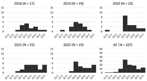
The survey received responses from a maximum of 107 students, with 48 of them attending online classes. show histograms of the level of simplicity and satisfaction for the exercise and the usability of the materials in the exercises. The values represent the ratings given by each student for the learning topics, which were then aggregated and averaged.
The results show that many students considered the exercises slightly complex (). , shows the satisfaction level was relatively high (with an average of 3.917). The histograms for the usability level of the materials reveal that most students evaluated the materials as moderately applicable ().
Figure 2 Evaluations of the simplicity of the exercises (average = 2.782). Values close to 1 indicate “negative (complex),” and values close to 5 indicate “positive (simple).”
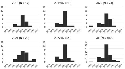
Figure 3 Evaluations of the satisfaction of the exercises (average = 3.917). Values close to 1 indicate “negative,” and values close to 5 indicate “positive.”
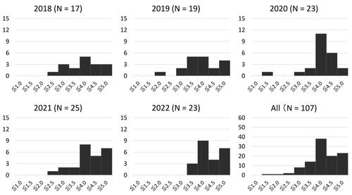
Figure 4 Evaluations of the usability of the materials (average = 3.366). Values close to 1 indicate “negative,” and values close to 5 indicate “positive.”
No statistically significant difference was found for the simplicity (p > 0.05) and satisfaction (p > 0.05) levels across the years (). Regarding usability, a statistically significant difference was confirmed (p ≤ 0.05) because course materials were updated based on student feedback and assignment results. Although no significant difference in the simplicity level was found between onsite and online classes, a statistically significant difference was identified in the satisfaction level (, ).
Figure 5 Comparison of the levels of simplicity and satisfaction between online and on-site classes.
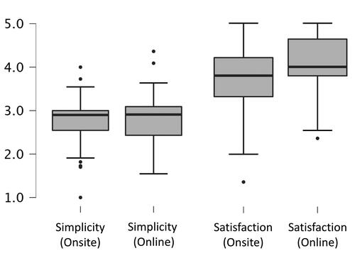
Table 6 Differences in students’ impressions to the exercises and the materials by Kruskal–Wallis test
Table 7 Differences in students’ impressions to onsite class vs online class by Mann-Whitney U test
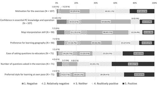
Among the students, 66.3 percent had positive or relatively positive motivation for the exercises (). About 40 percent to 50 percent of the students answered the items regarding confidence in essential computer knowledge and map interpretation skill as “neither.” Only 24.5 percent of the students had a negative impression of geography learning when they were junior or senior high school students. Although many students believed they could easily ask the instructors questions, they did not ask many questions in the exercises. Many students, though, indicated they could learn GIScience without significant difficulty using this self-learning method.
Figure 6 The answers of questionnaire items (N = 107). Values represented in each bar indicate the number of students.
presents pairs of correlation coefficients greater than 0.3 and p values less than 0.05 between Type 1 and Type 2 questions. Simplicity for the exercises was correlated with confidence in essential computer knowledge and operation, as well as the preferred style for learning at their own pace. Satisfaction with the exercises and the usability of the materials were correlated with motivation for the exercises, the preferred style for learning, and the number of questions asked in the exercises. Additionally, the evaluation of the usability of the materials showed a correlation to the ease of asking questions to educator.
Table 8 Items correlated between Type 1 and Type 2 questions
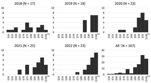
Furthermore, we evaluated assignment scores for each year (). The number of assignments slightly differed between 2018, 2019, and other years. The assignment achievement rate was the lowest for all exercises in the 2018 class, at 75.7 percent. In other years, the assignment achievement rate ranged from 86.5 percent to 93.2 percent. The majority of the mistakes were related to spatial coordinate conversion. From the 2019 class onward, which included video tutorials and oral explanations for spatial coordinates, these mistakes decreased dramatically.
Figure 7 Assignment achievement rate.
Discussion
This section discusses the challenges of GIScience learning using our materials and the educational advantages of these materials under our teaching method.
Simplicity and Complexity of the Developed Materials
The results show that most students found geospatial data processing exercises slightly complex. Although the materials had been revised based on student feedback, there was no statistically significant difference in evaluating the simplicity level over the years. GIScience education inherently has some fundamental complexities, making it hard for students to acquire spatial data processing skills. Based on our surveys, the complexities that students experience while using GIS software can be roughly categorized into two issues: (1) interpreting spatial data processing, and (2) mastering essential computer knowledge and operation.
The former refers to understanding unique data processing and interpretation related to GIScience, such as spatial coordinate conversion. The results indicate complex issues in GIScience, some of which students do not understand easily. Video tutorials and verbal explanations reduce mistakes, however, when students try data processing and map creation. Specifically, oral instructions, including communication with students, lead to a sufficient understanding among learners (Vojteková et al. Citation2021). For GIScience learners, asking a more experienced person is as effective as self-learning using Internet searching (Rickles, Ellul, and Haklay Citation2017). Conversely, students’ understanding speed differs in each educational context. A GIScience class that adopts only one teaching method, such as simultaneous teaching, cannot quickly reduce the complexity of learning GIScience knowledge and software operation. Therefore, promoting multiple ways of learning helps students. Video tutorials and text explanations enhance students’ understanding because they can watch or read the contents repeatedly when they cannot understand topics from the educators’ oral descriptions.
Concerning the latter issue, GIScience exercises require students to have a wide range of basic computer knowledge to operate the software for data processing. Educators often encounter students who lack this knowledge, such as searching directories, creating folders, and understanding file extensions (Bearman, Munday, and McAvoy Citation2015). Some trainees have a negative impression of a broader range of basic computer operations than just GIS applications (Walshe Citation2017). We have also confirmed a correlation between basic computer knowledge and the level of simplicity for the exercises through questionnaire surveys. Several students stumbled on basic computer processing tasks, such as how to extract zip files. Education on basic computer knowledge and its usage, not directly related to GIScience teaching, should be minimized due to the limitation of the university timetable. For effective GIScience education in universities, students should learn basic computer operating skill in high school beforehand to conduct spatial data processing and map creation. In recent years, Japan’s school education has shifted to incorporate information technology(IT). A new geography subject, including GIS applications, became compulsory in Japanese senior high school education in 2022 (Ministry of Education, Culture, Sports, Science, and Technology Citation2018). Basic computer knowledge and its operations related to GIS will be expected to be developed in this education, reducing the problems associated with computer operation in university GIScience education.
In our surveys, no correlation was found between map interpretation skill and preference in learning geography in the past regarding the level of simplicity in learning GIScience, despite GIS being an effective tool for spatial thinking (Jo, Hong, and Verma Citation2016). These results also suggest significant differences between learning traditional geographical skills, such as reading maps, and spatial data processing using software. We might, therefore, need to consider a different approach to learning spatial data processing apart from traditional geography education.
Advantages of the Developed Materials and Teaching Method
Most students evaluated the materials as simple to use, especially in the late stages, suggesting that improving the materials based on student feedback effectively enhanced their usability. Pendyala and Vijayan (Citation2018) also noted that feedback from course participants can help identify gaps and assess the suitability of the course design for modification. An advantage of our materials is that they are published as open access, enabling students to learn GIScience after class. The shift to online GIScience course methods due to COVID-19 has led to issues regarding how educators can support their students (Kim Citation2021). We conducted successful classes, however, using our online materials and teaching methods. During distance learning, teachers must consider how to help students using available technology. Žoncová, Vojteková, and Tirpáková (Citation2023) reported on the usefulness of Google Classroom in teaching GIScience, but they also showed some challenges related to quick communication between teachers and students or among students. In our case, many students could learn GIScience, but some strongly desired educators’ assistance when they encountered questions or difficulties. The results indicate that educational technologies, including our online materials, are helpful for learners. Still, they might be unable to replace human communication related to GIS software operation and GIScience learning.
The students experienced various data processing in our exercises corresponding to the Geographic Information Science: GIS Standards textbook (Asami et al. Citation2015). They received systematic training in GIScience, covering topics from physical geography to human geography. Many students expressed satisfaction with the GIScience learning. Some students, however, reported feeling unsatisfied with the classes due to low motivation or disliking the self-learning style. Self-efficacy is essential for practical GIScience learning for trainees (Walshe Citation2017), and motivation is a significant factor in student success (West Citation2003). Using the software, real-world experiences, and geographical data exploration can pique students’ motivations and interests (Baker, Palmer, and Kerski Citation2009). In our case, 66.3 percent of students were motivated to learn GIScience. One possible reason is that the students quickly conceptualized GIS applications due to their earth and planetary sciences major. Therefore, the level of satisfaction with our materials might vary depending on the user’s specialization.
Generally, GIScience exercise classes in Japanese universities adopt a simultaneous teaching method in which educators process data while showing their software operation on a screen. Students follow along while attempting the data processing on their own computers. Using this method, some students might feel frustrated or dissatisfied due to differences in their computer operating and learning speed. Ooms et al. (Citation2015) reported that students had different impressions about lecture speed through Web lectures using videos, including the GIScience exercise. In our exercise, students could learn geospatial data processing at their own pace while reading the materials. If they encountered technical issues when operating the software, the students could quickly receive support from the educators, resulting in relatively high satisfaction. Pendyala and Vijayan (Citation2018) suggested a multilevel training implementation plan incorporating physical presence and self-learning to ensure efficient lesson time. Adopting a self-directed learning approach in GIScience instruction has been successful, as students have expressed appreciation for the flexibility to learn at their own pace (Bearman et al. Citation2015). Argles (Citation2017) conducted remote GIScience classes and suggested that educators can maximize student success in GIScience learning by providing both static support, such as screencasts embedding learning materials, and dynamic support from topic specialists and peers. Therefore, it is crucial to design GIScience class plans and educational materials that are effective for both simultaneous teaching and self-directed learning using educational materials based on students’ progress and GIScience learning skills.
Conclusions
From this study, we derive two main conclusions. First, students are required to have fundamental skills. To conduct simple GIScience education for students, they must have a fundamental knowledge of the following skills: (1) interpretation of basic GIScience concepts such as spatial coordinates, and (2) essential computer knowledge required to operate GIS software. The former skill has traditionally been taught at universities, but simultaneous teaching might only sometimes be practical. In our classes, even though the students learned GIScience with minimal support from educators, many were relatively satisfied and received enough assignment scores because our materials enabled them to learn at their own pace. Nevertheless, GIScience education can be fundamentally complex for beginners. For topics students find challenging to read and understand in textbooks, educators should provide attentive support through verbal explanations and video tutorials. On the other hand, teaching basic computer knowledge related to utilizing GIS software to university students is limited by the shortage of class hours. This issue is expected to be resolved in the future, however, as Japan’s school education policies now emphasize IT use.
Second, educators should consider devising ways to increase students’ motivation. Designing exciting learning topics for students that correspond to their majors and interests is necessary. Although many students prefer GIScience class using online materials, achieving a GIScience class in which educators can quickly respond to students’ troubles and questions is essential. There is also a need to consider how to develop educational resources to popularize GIS applications in society and examine ways to increase the usefulness and effectiveness of self-learning.
Further analysis and discussion are necessary to evaluate the effectiveness of IT-based educational materials for GIScience education in promoting knowledge transfer to students. We plan to conduct a follow-up questionnaire survey with students to assess whether our materials have aided their learning and if they continue to apply GIScience skills. Such surveys serve a dual purpose: They help determine the long-term effectiveness of teaching materials and university courses while contributing to improving current classes. Therefore, these initiatives can be considered significant within the context of the SoTL. In this study, we investigated the educational impact of GIScience learning in a short-term university course. GIS users typically engage in continuous GIScience learning over time, however, accumulating new knowledge and skills through practical experiences. During this process, open-access materials could play a valuable role in supporting their learning, as they can be accessed online anytime, even after the class has ended. Hence, it is essential to consider various approaches to enhance GIScience learning based on current issues. We will augment the materials, including lecture resources, to create an educational environment where students can study GIScience and related knowledge in the long term, independent of instructors and the constraints of university class numbers. In this context, it is also crucial to acknowledge the value of other online educational resources and ensure they are accessible from our materials. To enhance learning transfer, we also need to consider a curriculum consisting of classical and practical topics, such as decision-making and product design using GIS.
Acknowledgments
We would like to thank three anonymous reviewers for their valuable and insightful comments.
Disclosure statement
No potential conflict of interest was reported by the author(s).
Additional information
Funding
Notes on contributors
Hiroyuki Yamauchi
HIROYUKI YAMAUCHI is an Associate Research Professor at Art Research Center, Ritsumeikan University, Kyoto 603-8577, Japan. E-mail: [email protected]. His research interests involve geography education using GIS and related technology.
Takashi Oguchi
TAKASHI OGUCHI is a Professor at the Center for Spatial Information Science, The University of Tokyo, Kashiwa 277-8568, Japan. E-mail: [email protected]. His research interests include hillslope geomorphology, fluvial geomorphology, geomorphometry, GIS applications, and GIS-related education.
Kotaro Iizuka
KOTARO IIZUKA is an Assistant Professor at the Center for Spatial Information Science (CSIS), The University of Tokyo, Kashiwa 277-8568, Japan. E-mail: [email protected]. His research interests lie in the field of environmental remote sensing. Various analysis is conducted utilizing data from optical and synthetic aperture radar satellite imagery to UAV-based studies. Applications are varied across fields, including forestry, urban studies, and earth sciences.
Yuichi S. Hayakawa
YUICHI S. HAYAKAWA is an Associate Professor in the Faculty of Environmental Earth Science, Hokkaido University, Sapporo 060-0810, Japan. E-mail: [email protected]. His academic focus is within the domain of environmental geography, with a particular focus on using high-definition earth surface data for geomorphology and related studies; this encompasses various aspects, including data acquisition, analysis, sharing, outreach, and education.
Toshikazu Seto
TOSHIKAZU SETO is an Associate Professor in the Faculty of Letters, Komazawa University, Tokyo 154-8525, Japan. E-mail: [email protected]. His research interests are based on social geography and geospatial analysis of various social phenomena. In particular, he specializes in fields such as participatory GIS and volunteered geographic information.
Literature Cited
- Aoki, K. 2023. Open data to QGIS de zerokara hajimeru chizudukuri [Creating maps from the beginning with open data and QGIS]. Tokyo, Japan: Kodansha.
- Argles, T. 2017. Teaching practical science online using GIS: A cautionary tale of coping strategies. Journal of Geography in Higher Education 41 (3):341–52. doi: 10.1080/03098265.2017.1315531.
- Asami, Y., K. Yano, Y. Sadahiro, and M. Yuda, eds. 2015. Geographic Information Science: GIS Standards. Tokyo, Japan: Kokon Shoin.
- Baker, T. R., A. M. Palmer, and J. J. Kerski. 2009. A national survey to examine teacher professional development and implementation of desktop GIS. Journal of Geography 108 (4–5):174–85. doi: 10.1080/00221340903435934.
- Bearman, N., N. Jones, I. André, H. A. Cachinho, and M. DeMers. 2016. The future role of GIS education in creating critical spatial thinkers. Journal of Geography in Higher Education 40 (3):394–408. doi: 10.1080/03098265.2016.1144729.
- Bearman, N., P. Munday, and D. McAvoy. 2015. Teaching GIS outside of geography: A case study in the school of international development, University of East Anglia. Journal of Geography in Higher Education 39 (2):237–44. doi: 10.1080/03098265.2015.1010146.
- Ciolli, M., B. Federici, I. Ferrando, R. Marzocchi, D. Sguerso, C. Tattoni, A. Vitti, and P. Zatelli. 2017. FOSS tools and applications for education in geospatial sciences. ISPRS International Journal of Geo-Information 6 (7):225. doi: 10.3390/ijgi6070225.
- DiBiase, D., M. DeMers, A. Johnson, K. Kemp, A. T. Luck, B. Plewe, and E. Wentz, eds. 2006. Geographical information science & technology body of knowledge. Washington, DC: The Association of American Geographers.
- Fagin, T. D., T. A. Wikle, and A. J. Mathews. 2020. Emerging geospatial technologies in instruction and research: An assessment of U.S. and Canadian geography departments and programs. The Professional Geographer 72 (4):631–43. doi: 10.1080/00330124.2020.1777573.
- Hashimoto, Y., ed. 2015. QGIS no kihon to bousai katsuyo [Fundamental concepts of QGIS and application to disaster prevention]. Tokyo, Japan: Kokon Shoin.
- Imaki, H. 2013. Quantum GIS nyumon [Introduction to Quantum GIS]. Tokyo, Japan: Kokon Shoin.
- Jo, I., J. E. Hong, and K. Verma. 2016. Facilitating spatial thinking in world geography using web-based GIS. Journal of Geography in Higher Education 40 (3):442–59. doi: 10.1080/03098265.2016.1150439.
- Kawabata, M., A. Okabe, T. Oguchi, H. Kohsaka, and Y. Murayama. 2005. Development of GIS core curricula: A curriculum draft, chapters 1 and 2. CSIS Discussion Paper 66:1–16.
- Kemp, K. K., and M. F. Goodchild. 1991. Developing a curriculum in geographic information systems: The National Center for Geographic Information and Analysis Core Curriculum project. Journal of Geography in Higher Education 15 (2):123–34. doi: 10.1080/03098269108709142.
- Kern, B., G. Mettetal, M. D. Dixson, and R. K. Morgan. 2015. The role of SoTL in the academy: Upon the 25th anniversary of Boyer’s scholarship reconsidered. Journal of the Scholarship of Teaching and Learning 15 (3):1–14. doi: 10.14434/josotl.v15i3.13623.
- Kim, M.-K. 2021. Continuity of instruction: Hands-on exercise in GIS course. SCHOLE: A Journal of Leisure Studies and Recreation Education 38 (2):118–19. doi: 10.1080/1937156X.2021.1978912.
- Lukinbeal, C., and J. J. Monk. 2015. Master’s in geographic information systems programs in the United States: Professional education in GIS and geography. The Professional Geographer 67 (3):482–89. doi: 10.1080/00330124.2014.983630.
- Marra, W. A., L. Van De Grint, K. Alberti, and D. Karssenberg. 2017. Using GIS in an earth sciences field course for quantitative exploration, data management and digital mapping. Journal of Geography in Higher Education 41 (2):213–29. doi: 10.1080/03098265.2017.1291587.
- Ministry of Education, Culture, Sports, Science, and Technology. 2018. Kotogakko gakushushido yoryo (heisei 30 nen koji) [High school curriculum guidelines (announced in 2018)]. Tokyo, Japan: Ministry of Education, Culture, Sports, Science, and Technology.
- Mui, A. B., S. Nelson, B. Huang, Y. He, and K. Wilson. 2015. Development of a web-enabled learning platform for geospatial laboratories: Improving the undergraduate learning experience. Journal of Geography in Higher Education 39 (3):356–68. doi: 10.1080/03098265.2015.1039503.
- Nahm, F. S. 2016. Nonparametric statistical tests for the continuous data: The basic concept and the practical use. Korean Journal of Anesthesiology 69 (1):8–14. doi: 10.4097/kjae.2016.69.1.8.
- Novo, A., I. Garrido, H. Lorenzo, and P. Arias. 2022. Use of geographic information systems (GIS) in higher education: Practical geomatics applications with Quantum GIS software. 2022 International Symposium on Computers in Education (SIIE). New York: IEEE. doi: 10.1109/SIIE56031.2022.9982364.
- Okabe, A. 2006. Education for geographic information science and geography. E-journal GEO 1 (1):67–74. doi: 10.4157/ejgeo.1.67.
- Ooms, K., P. D. Maeyer, B. D. Wit, R. Maddens, T. Nuttens, N. Van De Weghe, and S. Vervust. 2015. Design and use of web lectures to enhance GIS teaching and learning strategies: The students’ opinions. Cartography and Geographic Information Science 42 (3):271–82. doi: 10.1080/15230406.2015.1011236.
- Pendyala, V. S. S. N. G. K., and D. Vijayan. 2018. Developing training programs in remote sensing and geospatial applications. ISPRS Annals of the Photogrammetry, Remote Sensing and Spatial Information Sciences IV-5 (5):1–6. doi: 10.5194/isprs-annals-IV-5-1-2018.
- QGIS Project. 2024. QGIS desktop user guide/manual (QGIS 3.28). Accessed February 16, 2024. https://docs.qgis.org/3.28/ja/docs/user_manual/.
- Rickles, P., C. Ellul, and M. Haklay. 2017. A suggested framework and guidelines for learning GIS in interdisciplinary research. Geo: Geography and Environment 4 (2):e00046. doi: 10.1002/geo2.46.
- Rip, F., G. Wallentin, and R. Van Lammeren. 2014. Integrated analysis of the demand for and supply of geospatial education and training—Results of the GI-N2K Surveys. Report No. 540409-LLP-1-2013-1-BEERASMUS-ENW, GI-N2K project, Genova, Italy. Accessed June 27, 2023. https://edepot.wur.nl/330999.
- Rosas-Chavoya, M., J. L. Gallardo-Salazar, P. M. López-Serrano, P. C. Alcántara-Concepción, and A. K. León-Miranda. 2022. QGIS a constantly growing free and open-source geospatial software contributing to scientific development. Cuadernos de Investigación Geográfica 48 (1):197–213. doi: 10.18172/cig.5143.
- Sadahiro, Y., M. Ota, H. Sato, K. Okunuki, T. Morita, and H. Kosaka, eds. 2012. Geographic Information Science Body of Knowledge (2012.6 version). Tokyo, Japan: The Research on Geographic Information Science Education and Spatial Thinking Project (JSPS KAKENHI Grant Number JP21240075).
- Sandhya, M. C. 2020. Exploring opportunities with open source GIS. International Journal of Engineering Research & Technology 9 (5):731–36.
- Sasaki, M., T. Oguchi, A. Okabe, and Y. Sadahiro. 2008. GIS education at geographical departments in Japanese universities in relation to the Japan standard GIS core curriculum. International Research in Geographical and Environmental Education 17 (4):298–306. doi: 10.1080/10382040802401540.
- Takahashi, A., and A. Okabe. 2008. Development of the online learning system for GIS practical training and implementations of classes. Theory and Applications of GIS 16 (1):49–58. doi: 10.5638/thagis.16.49.
- Tate, N. J., and D. J. Unwin. 2009. Teaching GIS&T. Journal of Geography in Higher Education 33 (Suppl. 1):S1–S6. doi: 10.1080/03098260903165964.
- University Consortium for Geographic Information Science (UCGIS). 2024. Current topics in the geographic information science & technology body of knowledge. Accessed February 15, 2024. https://www.ucgis.org/assets/docs/BoK/Topic_Overview_1_15_2024.pdf.
- Vojteková, J., A. Tirpáková, D. Gonda, M. Žoncová, and M. Vojtek. 2021. GIS distance learning during the COVID-19 pandemic (students’ perception). Sustainability 13 (8):4484. doi: 10.3390/su13084484.
- Wallentin, G., B. Hofer, and C. Traun. 2015. Assessment of workforce demands to shape GIS&T education. Transactions in GIS 19 (3):439–54. doi: 10.1111/tgis.12148.
- Walshe, N. 2017. Developing trainee teacher practice with geographical information systems (GIS). Journal of Geography in Higher Education 41 (4):608–28. doi: 10.1080/03098265.2017.1331209.
- West, B. A. 2003. Student attitudes and the impact of GIS on thinking skills and motivation. Journal of Geography 102 (6):267–74. doi: 10.1080/00221340308978558.
- Yamauchi, H., T. Oguchi, Y. S. Hayakawa, and T. Seto. 2019. Development and evaluation of open-access e-learning materials for GIS education based on the existing core curriculum and body of knowledge. E-Journal GEO 14 (2):288–95.
- Žoncová, M., J. Vojteková, and A. Tirpáková. 2023. Distance learning of geographic information systems using Google Classroom: Students’ assessment and perception. The Professional Geographer 75 (5):763–75. doi: 10.1080/00330124.2022.2148696.
