Abstract
We have estimated methane (CH4) emission from total rice (Oryza sativa L.) paddies in Japan by means of a process-based biogeochemistry model, DeNitrification-DeComposition(DNDC)-Rice, combined with a geographic information system (GIS) database of climate, soil and farming practices. In the GIS database, 2 million ha of rice paddies were divided into 17,408 units according to 136 climate areas, 16 soil types, four classes of drainage rate and two classes of groundwater level, to simulate CH4 flux from each of the units applying the DNDC-Rice model. As a result, the national-scale CH4 emission in 1990 was estimated to be 216 Gg carbon (C), 13% lower than a previous inventory estimated by the Tier 2 method. By our Tier 3 approach, a relatively higher CH4 flux was estimated from eastern regions than from western regions of Japan, presumably due to the differences in climate and water management. Sensitivity analysis and uncertainty assessment indicated that it is important to account for the heterogeneity in soil properties such as field water capacity, iron (Fe) concentration and drainage rate, in order to reduce the uncertainty in regional estimates.
1. INTRODUCTION
Methane (CH4) is the second most important greenhouse gas (GHG). It has a global warming potential that is about 25 times larger than that of carbon dioxide on a time horizon of 100 years (IPCC Citation2007), and its emission is regulated by Kyoto protocol in 1990. Hence, its rising concentration is a matter of concern. Almost 40% of global CH4 emission originates from the agricultural sector, from sources such as wetland rice (Oryza sativa L.) fields (i.e., paddy fields) and livestock. Several studies estimated that the global CH4 emission from paddy fields accounted for more than 10% of its total anthropogenic emissions (Burke and Lashof Citation1990; Li et al. Citation2006; USEPA Citation2011). In the 1980s, paddy fields were responsible for about 18% of the total CH4 emission (Burke and Lashof Citation1990; Rosenzweig and Hillel Citation1998). We also note that this GHG source has a possibility to mitigate global warming by improving farming management techniques, as pointed out by the Intergovernmental Panel on Climate Change (IPCC Citation2007).
IPCC (Citation2007) recommends three tiers of methods to estimate national scale GHG emissions: the Tier 1 method is the simplest one that uses default emission factors proposed by IPCC, while the Tier 2 method involves country-specific information to calculate the emission factors. The Tier 3 method, on the other hand, involves models or inventory measurement systems, which are tailored to address national circumstances and driven by high-resolution activity data disaggregated at a sub-national scale. In Japan, the national-scale CH4 emission from rice production has been estimated based on IPCC Tier 2 methodology (GIO Citation2011), in which paddy fields were categorized into two groups, i.e., intermittently flooded fields (assumed to represent 98% of the total) and continuously flooded fields (2%). By this method, however, quantitative evaluation including spatial variabilities of climate, soil environment and management practice may not be enough. An important factor that was not accounted for by the Tier 2 approach is the drainage condition of paddy fields. In Japan, the governmental project of paddy fields improvement (PFI) was carried out from 1968 in order to optimize agricultural works and to improve rice production (Hasegawa and Tabuchi Citation1995). Through the PFI project, drainage facilities such as culverts and ditches have been installed in more than 60% of paddy fields (MAFF Citation2003) to enhance drainage from the fields. In a previous study to estimate GHG emission factors from upland fields (Akiyama et al. Citation2006), soil drainage was categorized into two groups based on soil type: (1) well drained soil such as Andosol, terrestrial Regosols and Yellow soil, and (2) poorly drained soils such as Wet Andosol, Brown Lowland soil, Gray Lowland soils, Gley soils and alluvial soil. Due to PFI, however, the drainage condition of a paddy field is not necessarily determined by soil type, and this will bring additional uncertainty into the GHG emission estimated by the Tier 1 and 2 approaches.
By combining geographic information system (GIS) and process-based models, in contrast, we can estimate GHG emission reflecting the spatial and/or temporal variations in climate and soil environment, including paddy field drainage condition affected by artificial facilities and farming management, based on the resolution of GIS data used. Recently, several studies have been done by such a Tier 3 approach to estimate regional GHG emission from rice fields in China (e.g., Li et al. Citation2005; Zhang et al. Citation2011a, Citation2011b) and India (Pathak et al. Citation2005; Babu et al. Citation2006). Fumoto et al. (Citation2008) developed a process-based biogeochemistry model, DeNitrification-DeComposition(DNDC)-Rice, aiming at estimating GHG emission from rice fields in Japan by the Tier 3 approach. At a regional scale, DNDC-Rice was applied to estimate GHG emission from rice fields in Hokkaido, Japan, in conjunction with the GIS database of soil, climate and farming management (Fumoto et al. Citation2010). In this study, we have estimated CH4 emission from total Japanese rice fields in 1990, the base year of the Kyoto Protocol, by applying DNDC-Rice combined with a national scale GIS database on soil, climate, farming management, and drainage condition of the paddy fields. We also analysed the uncertainty in the Tier 3 estimates of regional CH4 emission due to the heterogeneity in soil properties.
2. MATERIALS AND METHODS
2.1. Outline of the DNDC-Rice model
The DNDC-Rice model was developed by modifying an integrative biogeochemistry model, DNDC (Li et al. Citation1992; Li Citation2000). The DNDC model mainly consists of three parts: soil climate, crop growth and soil biogeochemistry. The soil climate part calculates soil moisture, temperature, and oxygen concentration based on the soil chemical and hydraulic properties and weather conditions. The crop growth part simulates crop physiology and phenology as affected by the climate and nitrogen availability. The soil biogeochemistry part, which is linked to the crop growth part, simulates various biogeochemical processes based on the soil chemical and physical properties and climate (Fumoto et al. Citation2008). In order to develop DNDC-Rice, major revisions were made to the submodels of soil climate and soil biogeochemistry: DNDC-Rice calculates daily variation in paddy water temperature to better simulate soil temperature of rice paddies. In the soil biogeochemistry part, also, DNDC-Rice tracks production of electron donors [molecular hydrogen (H2) and dissolved organic carbon] through decomposition and rice root exudation, and their consumption for soil reduction and CH4 production, in order to simulate CH4 emission from rice paddy fields under a wide range of climatic and agronomic conditions. DNDC-Rice model was validated at five sites in Japan by Fumoto et al. (Citation2008, Citation2010).
2.2. Simulation unit
Simulations were conducted for polygons created by climate, soil type, drainage condition and groundwater level. A digital soil map with a scale of 1:50,000 for cropland in Japan as of 1992 (Takata et al. Citation2009) was used to construct a database of paddy field area and soil type. On this digital soil map, we overlaid the distributions of drainage index and groundwater level (GWL) obtained from a survey map on land use and infrastructures by 1:25,000 except for Hokkaido area with a scale of 1:50,000 (Rural Development Bureau, MAFF Citation1993, Citation2001).
All paddy field polygons were classified into categories by combining the 16 soil groups, four classes of drainage index, two classes of GWL and 136 climate areas, and the resulting 17,408 categories were the simulation units in this study. The names of regions, prefectures, and stations of Automated Meteorological Data Acquisition System (AMeDAS) which represent the climate areas are described in Table S1. The paddy field area in 1990 was about 2.08 million ha (MAFF Citation2010b). Output CH4 flux was evaluated by the regions also listed in Table S1.
2.3. Model input data
2.3.1. Climatic data
DNDC-Rice requires climatic data of daily maximum and minimum temperatures and precipitation. The Japan Meteorological Agency (JMA) divides each prefecture of Japan into a few climate areas, and we selected a total of 136 meteorological observation stations to represent each of these climate areas. If temperature data are missing, we estimated them by interpolation with data of neighbour days, but missing precipitation data were substituted with zero.
2.3.2. Soil properties
The detailed information on soil properties required by the DNDC-Rice model as input data are described in Table S2. For soil properties such as soil organic carbon (SOC), clay content (clay), pH and bulk density (BD), we derived the average for each of the 16 soil groups from MAFF (Citation2008).
The DNDC-Rice model also requires the input of biologically reducible iron (FeBR), which is the major electron acceptor in soil that affects the soil redox status and CH4 production rate. The concentration of FeBR was estimated from the free iron oxide concentration using the following regression equation derived from anaerobic incubation data on Japanese paddy soils (Smakgahn et al. Citation2009):
where FeBR is the biologically reducible Fe (mg g–1 soil), and freeFe is the free iron oxide concentration in surface soil (mg g–1 soil).
2.3.3. Drainage index and drainage rate
In accordance with the guideline for the field survey (MAFF Citation2001), we set the drainage rate for each paddy field by the following categories; rapid, moderate, poor and unknown (15, 10, 5 and 10 mm day–1 respectively). The survey classified the drainage condition of each polygon of paddy fields into four categories, with respect to crop growth and agricultural machinery operation; the index was decided based on semi-quantitative measurements of the drainage rate just after the field improvement. The rapidly draining fields are regarded as available for rotation between paddy and upland fields and the drainage range was described as from 20 to 50 mm day–1 in the guideline, whereas the poorly draining fields are subject to undesired flooding for more than 24 h on occasions of heavy rainfall. On the other hand, the moderately draining fields are described as available for paddy fields, not suitable for upland crop growth conditions, and their drainage range was described as from 10 to 50 mm day–1.
The drainage rate of paddy fields described by the guidelines (MAFF Citation2001) had a wide range, and referred to the drainage rate immediately after the Paddy Fields Improvement (PFI) project (from 1950s to 1970s). Considering the aging of drainage facilities, therefore, the practical drainage rate was estimated to be lower than those described by the guidelines. In addition to this background, a literature survey by Yamazaki (Citation1960) showed that the water requirement depth of high-yield paddy fields was around 20 mm day–1, including approximately 5 mm day–1 of evapotranspiration from the water surface (Yamazaki, Citation1960, Citation1971). Consequently, the practical percolation rate was estimated to be around 15 mm day–1. The rapidly draining paddy corresponded to the high-yield paddy fields, and then the drainage rate of “rapid” was assumed to be 15 mm day–1 in this study. The drainage rate of moderately draining field was assumed to be 10 mm day–1, and this was validated on the validation sites in Niigata and Shizukuishi where the drainage index was “moderate”. The poor drainage rate was assumed to be 5 mm day–1, less than the moderate drainage rate. We have little information to judge which drainage type was included in “unknown” paddy fields. However, as the digital soil map (Takata et al. Citation2009) contains the drainage information of improved paddy fields by PFI (Rural Development Bureau MAFF Citation1993), most of the “unknown” paddy fields were considered to be non-improved paddy fields. Therefore, we assumed the drainage rate of “unknown” to be the same as “moderate” (10 mm day–1).
In the DNDC-Rice, it calculates the soil water balance with the following equation:
where Wi is the soil moisture in the ith layer, t is the time (t), FWCi is the field water capacity in the ith layer, and ETi is the evapotranspiration rate in the ith layer. The parameter D was derived from the drainage index provided in a survey by the Rural Development Bureau MAFF (Citation1993, Citation2001).
2.3.4. Ground water level and field water capacity
Field water capacity (FWC) was estimated from the soil type and GWL given in the MAFF (Citation2008) survey, which classified GWL of cropland into two classes, deeper or shallower than 70 cm (70D and 70S, respectively); 70D is considered to be suitable for crop growth and the use of machinery. For each of the 16 soil groups, we estimated FWC (expressed as water-filled pore space, WFPS; Linn and Doran, Citation1984) of 70D fields based on the average soil moisture at pF1.5, at equal to 3.1 kPa, and the average porosity. For 70S fields, we assumed that the water potential of GWL was 10 cm H2O higher than 70D in accordance with the guidelines (MAFF Citation2001) for rice paddy drainage. The detail explanation about FWC for each GWL was described in Table S2. The drainage index was also divided into two types based on GWL.
In this paper, abbreviations of rapid70D, rapid70S, modelate70D, moderate70S, poor70D, poor70S and unknown, were used for express drainage conditions and ground water level.
2.3.5. Farming management practices
DNDC-Rice requires the following data on farming management: (1) transplanting date, (2) harvesting date, (3) tilling date and depth, (4) date, type and rate of manure and fertilizer application and (5) irrigation date. We compiled these data from the guideline for rice crop calendars published by Japan Agricultural Cooperatives or from the statistical survey conducted in each of the 136 climatic zones. The main rice cultivar in each area was selected based on the planted area ratio in 2000, as provided in the database for rice cultivars developed by Ohta et al. (Citation2004). We assumed that farming management was uniform in each climate zone and followed the crop calendars.
The timing and amount of nitrogen application was obtained from published guidelines for the recommended rate of fertilizer application or rice crop calendars from Japan Agricultural Cooperatives or agricultural experimental stations in some prefectures (e.g., MAFF Citation2010a, Citation2010b).
The manure application rate from 1980 to 1990 was derived from national surveys on the cost of rice production (MAFF Citation1980–1990). The amount of crop residue input to soils was estimated from yield by using the proportions of dry matter production of each part of the rice plant: 37.2% grain, 8.2% chaff, 44.6% leaves and stalks, 6.7% stubble and 3.3% roots, as reported by Ogawa et al. (Citation1988). All roots and stubble and certain proportions of chaff, leaves and stalks were assumed to enter soils. The survey on the distribution of chaff, leaves, and stalks for 11 regions (see Table S1) by the Council of Soil Function Survey for Mitigating Global Warming (Citation2013) was used to estimate proportions of such residues that entered soils. Residues of other crops planted in paddy fields (e.g., winter wheat after summer paddy rice) were estimated similarly by using yield.
The water regime was assumed to involve multiple drainage events including midseason drainage (for at least 5 d) for all regions except Hokkaido (MAFF Citation2010b). For those areas that had little information regarding irrigation in the published guidelines, we assumed that the drainage period was almost the same as the adjoining area with the same rice cultivar, transplanting date and geography. The minimum water management scenario set the 7-day drainage on 60 d after transplanting, almost equal to the continuous flooding, because the guidelines for the rice crop calendar (e.g., MAFF Citation2010a) recommends more than one-time drainage through the irrigation period in Japan. Input farming management of 136 climate zones is shown in Table S1.
2.3.6. Model simulated with national-scale database
In this study, we constructed the GIS database mentioned above and carried out a national-scale estimation for the period 1980 to 1990. First, DNDC-Rice was run for 30 yr as a spin-up (Fumoto et al. Citation2008 in detail) using the data for 1980, in order to initialize the soil carbon pools to a nearly steady state. After the 30 yr of spin-up run, the total paddy area in each prefecture was adjusted for 10 yr in accordance with the yearly statistics, while the fraction occupied by each category was assumed to be constant. For the last 10 yr, precipitation and temperature data from 1980 to 1990 were used, whereas we used the same crop calendar for that period. For organic matter input, we used statistical data from 1980 to 1990 on the amounts of organic matter from plant residues and manure applied in each prefecture.
2.4. Sensitivity analyses and uncertainty assessment
Uncertainties in regional GHG inventory can originate from (1) conceptualization, (2) models, and (3) input data and assumptions (IPCC Citation2007). Among these uncertainty sources, we analyzed the uncertainty due to the heterogeneity of soil properties in input data.
Prior to the uncertainty assessment, we performed a sensitivity analysis for paddy field of GrL in Ibaraki-Nanbu as an example, by varying a single input parameter in a predefined range, while keeping all other input parameters constant. The details of the baseline scenario are shown in . In order to analyze the sensitivity to soil properties, water regime and drainage rate were assumed to be uniform, i.e., continuous flooding (CF) and rapid drainage with deeper GWL, respectively. In the alternative scenarios, the farming management applied on Ibaraki-Nanbu was set to conventional (CV) management. Each soil property was set to the maximum and minimum values by standard deviation (see Table S2) reported in the soil survey dataset (MAFF, Citation2008). Drainage rate was alternated between rapid, moderate, and poor (i.e., 15, 10, and 5 mm day–1). The details of the baseline and alternative scenarios are listed in .
Table 1 Management and environmental conditions in the Ibaraki-Nanbu area for the baseline and alternative scenarios used for the sensitivity test
To evaluate the uncertainty due to spatial heterogeneity of soil properties at a regional scale, we applied the most sensitive factor (MSF) method developed by Li et al. (Citation2004). In this method, the most sensitive factors of each soil property which were found by sensitivity analysis were selected to obtain two scenarios to simulate the highest and lowest CH4 fluxes, thus estimating the probable range of CH4 flux from a specific region. When compared to Monte Carlo analysis, 70–98% of the Monte Carlo-produced CH4 flux was included in the MSF-produced flux range (Li et al. Citation2004). For conducting the MSF method, we selected the CV water regime in the Ibaraki-Nanbu area, where irrigation is applied from 19 April to 31 August, as the typical management among the areas in Kanto-koshin region (Table S1). During this irrigation period, drainage was applied eight times including the midseason drainage, making a total of 28 non-flooded days. Based on the sensitivity analysis, the input value of each soil property was selected within a given range to simulate the minimum and maximum CH4 fluxes. Therefore, this method could find the error range of estimated CH4 flux due to soil heterogeneity.
3. RESULTS AND DISCUSSION
3.1. Estimation of methane emission from paddy fields
We obtained the calculation result of the regional distribution of annual CH4 emission in each of 136 climate zones in 1990. Specific description of the CH4 emissions are provided in Table S1. A large amount of CH4 was emitted from the rice-producing area in eastern Japan, including the Tohoku region, whereas CH4 emission was comparatively small in the western part of Japan. also shows the regional difference of paddy area and CH4 emissions. In 1990, while 25% of paddy fields were located in Tohoku region, that region contributed 54% of the national CH4 emission. This heterogeneity in simulated CH4 emission may be attributed to the regional differences in climate, soil type distribution and water regime. In Tohoku region, the cool climate retards decomposition of organic matter in fallow season, and relatively lower drainage (Table S1) can enhance CH4 production in rice growing season. Obviously, an analysis of regional variation in CH4 emission is difficult by Tier 1 and 2 approach.
Figure 1 Methane (CH4) emission and paddy area in 1990. The ratio of methane emission and paddy area classified by (a) the 11 regions, (b) soil group and (c) drainage and groundwater level, respectively. Abreviations of soil groups are as follows: L: Lithosols; RS: Regosols; A: Andosols; AW: Wet Andsols; AG: Gleyed Andosols; B: Brown Forest soils; GrU: Gray Upland soils; GU: Gley Upland soils; R: Red soils; Y: Yellow soils; DR: Dark Red soils; BL: Brown Lowland soils; GrL: Gray Lowland soils; G: Gley soils; M: Muck soils; and P: Peat soils.
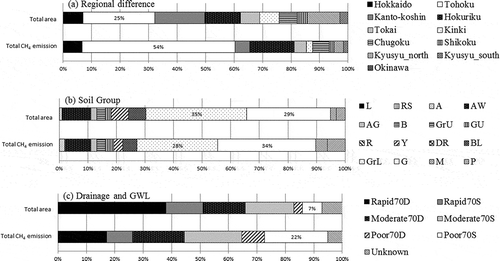
illustrates the proportion of each soil group in the total paddy area and total CH4 emission from paddy soils. The two major soil groups were Gray Lowland soil (GrL) and Gley soils (G), which occupied about 35% and 29%, respectively, of the total paddy area in 1990. Total CH4 emission from all paddy fields in 1990 (2.08 million ha) was estimated to be about 216 Gg C yr–1, and the average CH4 flux was, therefore, about 104 kg C ha–1 yr–1. The G and GrL soil groups were the top two contributors to total CH4 emission, contributing about 28% and 34%, respectively (), followed by Wet Andosols (AW), Brown Lowland soils (BL), and Peat soils (P). Methane emission levels from Lithosols (L), Regosols (RS), Brown Forest soils (B), Red soils (R) and Dark Red soils (DR) were smaller than from the other soil groups. With the exception of Andosols (A), the contribution from each soil group to the total CH4 emission followed the order of paddy area of these soil groups.
Figure 2 Average methane (CH4) flux from different soil groups and drainage indices. Labels indicate the drainage index and soil group name in the Japanese system. L, Lithosols; RS, Regosols; A, Andosols; AW, Wet Andsols; AG, Gleyed Andosols; B, Brown Forest soils; GrU, Gray Upland soils; GU, Gley Upland soils; R, Red soils; Y, Yellow soils; DR, Dark Red soils; BL, Brown Lowland soils; GrL, Gray Lowland soils; G, Gley soils; M, Muck soils; P, Peat soils.
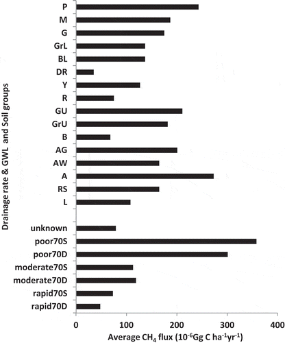
Figure 3 (a) Sensitivity of methane (CH4) flux to soil properties under continuous flooding (CF) and conventional (CV) water regime; (b) baseline CH4 flux under different drainage rates and CF. SOC, soil organic carbon; BD, soil bulk density; FWC, field water capacity.
As shown in , the largest contribution to CH4 emission (> 20%) came from paddy areas with a poor drainage and shallow GWL (poor70S), although such paddies accounted for only 7% of the total paddy area. In contrast, rice paddies with rapid drainage with deep GWL (70D) occupied 38% of the total paddy area, but contributed only 17% to the total CH4 emission.
The average CH4 flux from each soil group and from the combination of drainage index and GWL are shown in . The average CH4 fluxes of GrL and G were 137 and 175 kg C ha–1 yr–1, respectively, which were slightly higher than the total average CH4 flux of 104 kg C ha–1 yr–1. This figure also indicates the wide difference in average CH4 flux due to the field drainage conditions: 46 and 353 kg C ha–1 yr–1 from Rapid70D and Poor70S, respectively. The area ratio of poor70S in Japan was only 7%, but these fields contributed around 22% of the total CH4 emission. In Akiyama et al. (Citation2006), for example, Yellow soil (Y) and Gley soil (G) are referred to as well drained and poorly drained soil, respectively. In our estimate, however, CH4 flux from these soil types widely varied depending on the field drainage condition: the average CH4 flux from Y and G with rapid drainage were 30.1 and 50.6 kg C ha–1 yr–1, respectively, while the average CH4 flux from Y and G with poor drainage were 288.4 and 343.1 kg C ha–1 yr–1, respectively.
Here, we should note that detailed water management may depend on the soil type or drainage condition (e.g., MAFF Citation2010a, Citation2010b), though it was not considered in this study. In future studies, therefore, we will link practical water management to the field drainage condition in order to reduce the uncertainty in regional estimates.
3.2. Sensitivity analysis and uncertainty quantification
In the regional simulation of this study, the median of each soil property was used to represent the soils of each soil group. In reality, however, each soil property has a considerable variation within the same soil group, and this will be the source of uncertainty for the regional estimate of CH4 emission. For example, DNDC-Rice model has a strong sensitivity to electron acceptors in soil such as reducible Fe (Fumoto et al. Citation2008).
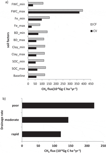
Responses of calculated CH4 emission under the continuous flooding (CF) and conventional (CV) water regimes are presented in . This result also indicates the effect of water management. In a comparison between CF and CV (both management differences are shown in Table S1), a difference of more than two times appeared at the CH4 flux of FWC_min (). In this paper, we set only one-time drainage, where we could not confirm the farming management especially for the water management. In such a case, calculated CH4 flux may tend to be overestimated.
Among the soil properties tested, field water capacity (FWC) and reducible Fe content had considerable effects on the CH4 flux calculated by the DNDC-Rice model. The Fe concentration in GrL showed a larger effect on CH4 flux than SOC, clay content and soil BD. FWC had the largest impact on annual CH4 flux: the difference in CH4 flux between maximum and minimum field water capacity (FWC_max and FWC_min) under the CV regime was more than 300 kg C ha–1 yr–1 (). The effect of the drainage index was also significant: the difference in CH4 flux between rapid and poor drainage was about 100 kg C ha–1 yr–1 for the case of FWC_70D (WFPS is 0.837).
We then quantified the error range of estimated CH4 flux due to soil heterogeneity by the MSF method (Li et al. Citation2004). Based on the sensitivity analysis, the upper limit of CH4 flux was calculated by choosing maximum SOC, minimum clay content, minimum BD, minimum Fe content, and maximum FWC (high value), whereas the lower limit of CH4 flux was calculated by choosing the opposite cases (low value). indicates the error range of CH4 flux from GrL paddy fields in Ibaraki-Nanbu, classified by drainage and GWL. The lowest flux, 8 kg C ha–1 yr–1, was obtained for the combination of rapid+70D+low value, whereas the highest flux, 608 kg C ha–1 yr–1, was obtained for poor+70S+high value.
Figure 4 Uncertainties in methane (CH4) flux from gray lowland soil (GrL) due to the soil heterogeneity in the Ibaraki-Nanbu area, quantified by the most sensitive factor (MSF) method. C, carbon.
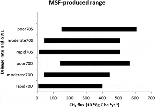
The MSF method produced a similar value, 507 kg C ha–1 yr–1, as the upper limit for rapid70S and moderate70S (), but this was attributed to a numerical limitation in the soil water balance subroutine in DNDC-Rice, as follows. The drainage rate of gravity water is calculated at an hourly time step by:
where D is drainage rate (mm h–1), water_move_f is the parameter of gravity water movement (0–1.0 h–1), PS is the porosity in a soil layer (expressed in mm), W is soil moisture (in WFPS), and FWC is the field water capacity (in WFPS). Due to the formulation of Eq. 3, D is restrained depending on the value of FWC. In the case of the high value of Rapid70S and Moderate70S, specifically, PS was 6.1 mm and FWC was set to 0.96. Accordingly, the maximum of D (for W = 1.0 and water_move_f = 1.0) was restrained at D = 5.9 mm day–1, and we could not simulate the drainage rates of 10 and 15 mm day–1. Consequently, the calculated high values for Rapid70S and Moderate70S should be considered as overestimates. This numerical limitation will be solved, however, by shortening the time step to about half an hour.
Based on the error ranges of CH4 flux as calculated above and the paddy area distribution, the error range of CH4 emission from the area was estimated to be 0.45 to 5.96 Gg C yr–1 (). When we used the average of each soil property, CH4 emission from this area was estimated to be 0.75 Gg C yr–1, thus the error range equals 0.6 to 7.9 times this estimate. This result clearly indicates that the uncertainty due to soil heterogeneity could be large, and thus should be quantified at the national scale. By the MSF method, however, we can identify the error range only. For more detailed assessment of the uncertainty, we will need to apply a statistical method such as Monte Carlo simulation, which takes into account the frequency distribution of soil properties.
Table 2 Methane (Ch4) emission levels from rice Oryza sativa L.) paddy under different drainage index in Ibaraki-Nanbu, as predicted by the DeNitrification-DeComposition(DNDC)-Rice model
3.3. Comparison with Tier 2 estimation
compared the estimated CH4 emission from rice paddies in this study with the previous estimates based on IPCC’s Tier 2 method (GIO Citation2011). We estimated the total emission of CH4 in 1990 as 216 Gg C yr–1, which is slightly lower than the GIO estimate of 249 Gg C yr–1. As the GIO (Citation2011) classified paddy soils into five soil types, we regrouped the 16 soil groups to match the GIO’s classification and calculated the average CH4 fluxes for comparison. The differences between the GIO’s (Citation2011) estimates and our own can be attributed not only to the process-based model structure, but also to the finer spatial/temporal resolution of activity data, such as field drainage rate, soil type and properties, precipitation, temperature, farming management practices and choice of rice cultivar, as an advantage of Tier 3 methodology.
Table 3 Comparison between the result of GIO (Citation2011) and this study
Comparing these two estimates, CH4 flux from each soil type as the national average was comparable except for the Andsols. In the Tier 2 estimate by GIO (Citation2011), the CH4 flux from Andosols was considerably lower than that from other soil types, but that was not the case in our study (). According to Tsuruta (Citation1997), the CH4 emission factor used by GIO (Citation2011) for Andosols was derived from three-season measurements on just two sites. This limitation of sample size may call into question the representativeness of the emission factor of Andosols. On the other hand, DNDC-Rice currently uses the same decomposition rate constant for humus of Andosols as that of other soil types, though Andosols are known to stabilize and accumulate humus (e.g., Nanzyo et al. Citation1993). Consequently, DNDC-Rice itself may tend to overestimate the humus decomposition rate in Andosols, resulting in overestimation of CH4 flux from that soil type.
Even though the national scale CH4 emission is similar between the Tier 2 and 3 estimates, we emphasize that our Tier 3 approach has computed the regional variation in CH4 emission due to the differences in climate, soil type, drainage conditions and farming management. This is quite important for building a national-scale mitigation strategy, because adoptable and effective mitigation techniques, such as water management of rice paddy, should be designed considering the regional differences in the above factors. As we employ a process-based model, furthermore, our Tier 3 approach will be able to predict future CH4 emission inventory reflecting the temporal change in climate and farming practices.
4. CONCLUSION
By combining the DNDC-Rice model and a GIS database, we have computed the first national-scale Tier 3 inventory of CH4 emission from Japanese rice paddies that reflects the regional differences in climate, soil type, drainage conditions and farming management. Such an emission inventory of high spatial resolution will be essential for building a national-scale mitigation strategy. To quantify and reduce the estimate’s uncertainty, we take into account the heterogeneity at a finer spatial scale in factors such as field water capacity, soil Fe concentration, drainage conditions and water management.
SUPPLEMENTARY MATERIAL
Supplementary material for this article is available online from http://dx.doi.org/10.1080/00380768.2013.836943
Supplemental table 2. Soil properties of each of the 16 soil types.
Download MS Excel (34.5 KB)Supplemental Table 1. Detail description of farming management in all 136 climate zone (1990-2005).
Download MS Excel (80 KB)ACKNOWLEDGMENTS
We thank Professer C. Li (University of New Hampshire) for his advice regarding the original DNDC model. We also thank Dr. Y. Shiratori (Niigata Agricultural Research Institute) and Y. Saito (Yamagata Integrated Agricultural Research Center) for their kind suggestions on drainage conditions and farming management data for simulation. We thank Dr. H. Obara (National Institute for Agro-Environmental Sciences, NIAES) for his help collecting farming management data from Agricultural Research Centers in some prefectures. We also thank Dr. Y. Takata (NIAES) for providing the digital soil map overlaid on drainage index.
REFERENCES
- Akiyama H, Yan X, Yagi K 2006: Estimations of emission factors for fertilizer-induced direct N2O emissions from agricultural soils in Japan: summary of available data, Soil Sci. Plant Nutr., 52, 774–787.
- Babu YJ, Li C, Folking S, Nayak DR, Adhya TK 2006: Field validation of DNDC model for methane and nitrous oxide emissions from rice-based production systems of India. Nutr. Cycl. Agroecosyst., 74, 157–174.
- Burke LM, Lashof DA 1990: Greenhouse gas emissions related to agriculture and landuse practices. In Impact of Carbon Dioxide, Trace Gases and Climate Change on Global Agriculture, Eds. Kimball BA, Rosenberg NJ, Allen Jr LH, pp. 27–43. American Society of Agronomy Special Publication No. 53. American Society of Agronomy, Madison, WI.
- Council of Soil Function Survey for Mitigating Global Warming (Ondan-ka taisaku dojou kinou chousa kyougi-kai) 2013: Report on greenhouse gas and soil carbon survey project (Dojo yurai onshitsu-kouka gas dojo-tanso chousa jigyou houkokusyo), Council of Soil Function survey for Mitigating Global Warming (Ondan-ka taisaku dojyou kinou chousa kyougi-kai) (in Japanese).
- Fumoto T, Kobayashi K, Li C, Yagi K, Hasegawa T 2008: Revising a process-based biogeochemistry model (DNDC) to simulate methane emission from rice paddy fields under various residue management and fertilizer regimes. Global Change Biol., 14, 382–402.
- Fumoto T, Yanagihara T, Saito T, Yagi K 2010: Assessment of the methane mitigation potentials of alternative water regimes in rice fields using a process-based biogeochemistry model. Global Change Biol., 16, 1847–1859.
- GIO 2011: National Greenhouse Gas Inventory Report of Japan, Ministry of the Environment, Japan, Greenhouse Gas Inventory Office of Japan (GIO), CGER, NIES. http://www.cger.nies.go.jp/publications/report/i100/i100.pdf (21 December, 2012).
- Hasegawa S, Tabuchi T 1995: Well facilitated paddy fields in Japan. In Paddy fields in the world, Eds. Hasegawa S.Tabuchi T, pp. 103–124. JSIDRE, Tokyo.
- IPCC 2007: Climate Change 2007: The Physical Science Basis. Contribution of Work Group I to the Fourth Assessment Report of the Intergovernmental Panel on Climate Change. Cambridge University Press, Cambridge.
- Li C 2000: Modeling trace gas emissions from agricultural ecosystems. Nutr. Cycl. Agroecosyst., 58, 259–276.
- Li C, Frolking S, Frolking TA 1992: A model of nitrous oxide evolution from soil driven by rainfall events. 1. Model structure and sensitivity. J. Geophys. Res., 97, 9759–9776.
- Li C, Frolking S, Xiao X, Moore B, Boles S, Qiu J, Huang Y, Salas W, Sass R 2005: Modeling impacts of farming management alternatives on CO2, CH4, and N2O emissions: a case study for water management of rice agriculture of China. Global Biogeochem. Cycl., 19, GB3010. doi:10.1029/2004GB002341
- Li C, Mosier A, Wassmann R, Cai Z, Zheng Z, Huang Y, Tsuruta H, Boonjawat J, Lantin R 2004: Modeling greenhouse gas emissions from rice-based production systems: sensitivity and upscaling. Global Biogeochem. Cycl., 18, GB1043. doi:10.1029/2003GB002045
- Li C, Salas W, DeAngelo B, Rose S 2006: Assessing alternatives for mitigating net greenhouse gas emissions and increasing yields from rice production in China over the next twenty years. J. Environ. Qual., 35, 1554–1565.
- Linn DM, Doran JW 1984: Effect of water filled pore space on carbon dioxide and nitrous oxide production in tilled and non-tilled soils. Soil Sci. Soc. Am. J., 48, 1276–1272.
- MAFF 1980–1990: Report of Statistical Survey on Farm Management and Economy (Production Cost of Rice, Wheat). Ministry of Agriculture, Forestry and Fisheries (in Japanese).
- MAFF 2001: The entry guideline for fourth Fundamental Research of Land Use Infrastructures, Ministry of Agriculture, Forestry and Fisheries (in Japanese).
- MAFF 2003: Statistics for agricultural construction, Ministry of Agricultrue, Forestry and Fisheries (in Japanese).
- MAFF 2008: The Soil Survey Dataset of the Basic Soil Environment Monitoring Project, Stationary Monitoring, 1979–1998. Ministry of Agriculture, Forestry and Fisheries (in Japanese).
- MAFF 2010a: The recommended rate for fertilizer. Ministry of Agriculture, Forestry and Fisheries (in Japanese). http://www.maff.go.jp/j/seisan/kankyo/hozen_type/h_sehi_kizyun/(31 March, 2013).
- MAFF 2010b: Statistics on Crops. Statistics Department, Ministry of Agriculture, Forestry and Fisheries (in Japanese).
- Nanzyo M, Dahlgren R, Shojo S 1993: Chemical characteristics of volcanic ash soils. In Volcanic Ash Soils: Genesis, Properties and Utilization, Eds. Shoji S, Nanzyo M, Dahlgren RA. Elservier, Amsterdam.
- NIAES 1983: Classification of cultivated soil in Japan, Second Approximation, National Institute for Agro-Environmental Sciences (NIAES) (in Japanese).
- Ogawa K, Takeuchi Y, Katayama M 1988: Biomass production and the amounts of absorbed inorganic elements by crops in arable lands in Hokkaido, and its evaluation. Res. Bull. Hokkaido Natl Agric. Exp. Station, 149, 57–91 (in Japanese with English summary).
- Ohta H, Ando I, Imbe T 2004: Construction of a rice characteristic database. Breed. Res., 6, 253 (in Japanese).
- Pathak P, Li C, Wassmann R 2005: Greenhouse gas emissions from Indian rice fields: calibration and upscaling using the DNDC model. Biogeosci. Discuss., 2, 77–102.
- Rosenzweig C, Hillel D 1998: Agricultural emissions of greenhouse gases. In Climate Change and The Global Harvest, Eds. Rosenzweig C, Hillel D, pp. 38–69. Oxford University Press, Oxford.
- Rural Development Bureau, MAFF 1993: The 3rd Fundamental Research of Land Use Infrastructures. Rural Development Bureau, Ministry of Agriculture, Forestry and Fisheries (in Japanese).
- Rural Development Bureau, MAFF 2001: The 4th Fundamental Research of Land Use Infrastructures. Rural Development Bureau, Ministry of Agriculture, Forestry and Fisheries (in Japanese).
- Smakgahn K, Fumoto T, Yagi K 2009: Validation of revised DNDC model for methane emissions from irrigated rice fields in Thailand and sensitivity analysis of key factors. J. Geophys. Res., 114, G02017. doi:10.1029/2008JG000775
- Takata Y, Nakai M, Obara H 2009: Digital soil map of Japanese croplands in 1992. Jpn. J. Soil Sci. Plant Nutr., 80, 502–505 (in Japanese).
- Tsuruta H 1997: Emission rates of methane from rice paddy fields and nitrous oxide from fertilised upland fields estimated from intensive field measurement for three years (1992–1994) all over Japan. Res. Rep. Div. Environ. Plan. NIAES., 13, 101–130 (in Japanese).
- USEPA 2011: Global Anthropogenic Non-CO2 Greenhouse Gas Emissions: 1990–2030. Office of Atmospheric Programs, Climate Change Division, U.S. Environmental Protection Agency, Washington, DC. http://www.epa.gov/climatechange/Downloads/EPAactivities/EPA_NonCO2_Projections_2011_draft.pdf (12 December, 2012).
- Yamazaki F 1960: Water requirement depth and percolation rate of paddy fields (Suiden no gensuishin, shintoryo). J. Jpn. Soc. Soil Phys., 3, 9–14 (in Japanese).
- Yamazaki F 1971: Paddy field engineering (Suiden no Kogaku). In Agricultural Engineering (Nouchi Kougaku), vol 1, p. 92. Tokyo University Press, Tokyo (in Japanese).
- Zhang Y, Wang Y, Su S, Li C 2011a: Quantifying methane emissions from rice paddies in northeast China by integrating remote sensing mapping with a biogeochemical model. Biogeosciences., 8, 1225–1235.
- Zhang W, Yu Y, Huang Y, Li T, Wang P 2011b: Modeling methane emissions from irrigated rice cultivation in China from 1960 to 2050. Global Change Biol., 17, 3511–3523.