
Abstract
The aim of the study was to examine and identify the scale of changes of bulk density, air-water properties and morphology in soils occurring in basins without outlets in northwestern Poland as a result of erosion and anthropogenic denudation. These processes are conditioned by a diversified relief, slope reduction, texture and land use, and modify the physico-chemical properties and morphology of soils of the tops and bottoms of basins without outlets. The basic effect of anthropogenic denudation is increased thickness of the humus horizon from 10–15 cm in forest to 25–30 cm in arable land and compaction of soil material. Erosion processes underlie the formation of deluvial soils. Eroded soils which occur on higher parts of the slopes in basins without outlets are more compacted and drier than deluvial soils. Soil texture and flora are some of the most important factors that determine the intensity of erosion processes. Denudation markedly diversifies the soil cover of morainic landscapes in Poland.
1. INTRODUCTION
Soil cover, especially in arable land with varied relief, is subject to degradation. In morainic landscapes, characteristic soil sequences are often seen, with eroded soils on slopes, deluvial soils in the lower parts of the slopes and organic soils in depressions (Orzechowski and Smólczyński Citation2010). This system plays an important role in element cycles and is a main factor stabilizing young glacial landscape functions (Major Citation2008; Smólczyński and Orzechowski Citation2010). The term “deluvial” refers to redeposited sediments as a result of geodynamic processes in an undulated landscape (Baužienė et al. Citation2008). For predicting future peneplanation of Quaternary landscapes and changes of soil properties, it is necessary to identify the main factors responsible for intensified erosion and anthropogenic denudation: soil texture, slope gradient, plant cover and land use. Agricultural slopes devoid of vegetation cover, or poorly covered, respond intensively or restrainedly to strong rainfall events that impoverish the soil, as well as to anthropogenic denudation. Sediments and minerals move down the slope along with runoff, supplying the lower parts of the area with components such as clay, silt, carbon, nitrogen, etc. Closed basins are very abundant in the landscape of moraine uplands. These numerous depressions have unique natural values and are also reservoirs of knowledge about past geomorphologic events.
2. MATERIALS AND METHODS
The study area is located within the Drawsko Lakeland, which is a part of the West Pomeranian Lakeland in northwestern Poland (). The study was conducted in one toposequence located in a selected basin without outlets in a young glacial landscape within a ground morainic plateau near Czaplinek. This landform was created during the melting of the ice sheet in the Late Pleistocene epoch, within the range of the Pomeranian phase of the last Weischselian/Würm glaciation (Maksiak and Mróz Citation1978; Kłysz Citation1990).
Figure 1 The study area: (A) Location, (B) Hipsometry and location of soil profiles, (C) Scheme of soil horizon. a.s.l., above sea level.
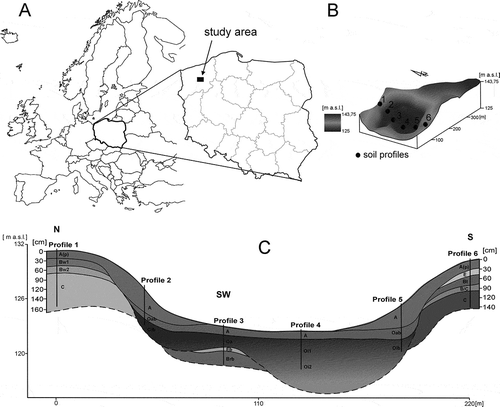
The study transect represented different types of land use (forest, grassland). In the past, the southern and northern part of the study area was used for agriculture purposes; now it is a grassland. The composition of crop species during agricultural use of this area in the past is unknown. Having analyzed archival sources and present-day cultivation on the western slope of the study area, it can be concluded that cereals were the previously dominant type of crop. The examined closed basin has been tilled for at least 400 years. At present, the northern part of the study area is covered with a spruce forest (Picea abies) with single specimens of Betula pendula. The vegetation cover of the remaining area comprises plant communities of Arrhenatherion with dominant species of Arrhenatherum elatius (Matuszkiewicz Citation2001). Currently, most of the research area is not tilled. Only the west slope of the examined closed basin is used for agriculture purposes, but it does not constitute a part of the study transect. Consequently, it is possible to determine the scale of transformations which have been preserved in soils up to the present. It is also possible to compare the intensity of soil erosion in different types of land use. The study area is relatively lithologically homogeneous. Eroded soils generally develop from loamy sand and their parent material has a sandy (profile 1 and 3) and sandy loamy texture (profile 6).
The thickness of Quaternary sediments in the closed basin of interest is about 35–45 m (Lewandowski et al. Citation2006). The slope gradient reaches 35° locally, which was responsible for soil erosion in the past. The elevation difference between the highest and lowest points of the study area is about 18.75 m. Haplic Luvisols and Brunic Arenosols occupy the highest and middle parts of slopes. At the border between slopes and the bottom are located Colluvic Regosols. The central part of the sedimentary basin, where the groundwater level is very high, is occupied by organic soils: Sapric Histosols (Novic) and Fibric Histosols (Drainic).
The soils were sampled in a standard way (FAO Citation2006). Soil samples were obtained in July 2011 for further laboratory analysis: texture by the Bouyoucos-Cassagrande method modified by Proszyński; bulk density (Bd) in undisturbed soil samples (mineral, organic) collected in four replications into 100 cm3 steel cylinders; total porosity (Tp) (Eq. 1); proportions of each phase (Eq. 2); specific density (Sd) (Eq. 3)—and total water resources (TWR) (Eq. 4)—Prusinkiewicz (Citation2004), were calculated according to the following equations:
where Sd is specific density; Bd is bulk density.
where Wr is water ratio; Tp is total porosity.
where SOM is soil organic matter.
where Sm is soil moisture (%); Bd is bulk density; h is thickness of soil genetic horizon.
3. RESULTS
3.1. Soil morphology changes
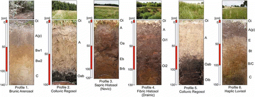
The distribution of deluvial soils in the young glacial landscape of northern Poland is very helpful in tracing its history and identifying patterns of soil erosion processes and changes in slope morphometry (Bork and Lang Citation2003). Thickness of deluvial soils depends basically on the relief, land use and texture of the eroded soils and flora. The thickness of allochthonous material in deluvial soils located at the base of the slopes in the study area is about 70–85 cm. It is usually 10–15 cm in non-transformed mineral soils occurring in forests and 25–30 cm in arable lands. As a result of slope processes, mineral material deriving from upper parts is transported down the slope and deposited on flat surfaces and in the bottom of the sedimentary basin. With closed water cycling, the soil material is retained inside the catchment despite erosion processes. In profiles 2 and 5, there are buried peat soils below the deluvial horizons.
It can be accordingly concluded that the bottom area of the basin without outlets was larger in the past. Reconstructions of the primeval soil cover reveal that the range of peat soils in the bottom of the sedimentary basin was larger by about 20% than it is today. Furthermore, the present-day soil erosion on the northern and southern slope of the research area is not observed. Dense vegetation cover protects the soil surface from strong runoff and soil material discharge. However, the assessment of the total quantity of eroded material as a result of agricultural practices is hampered. The direct, contemporary field studies revealed that the total amount of eroded material is 5.4 kg ha−1 while around 0.8–1.8 kg ha−1 derives from anthropogenic denudation during field work and vegetation period. It is difficult to precisely estimate how much allochthonous material was accumulated on the organic soils located in the sedimentary basin bottom in historical times, during 400 years of tillage. At the base of contemporary measurements of soil erosion and anthropogenic denudation, it can be concluded that present-day mineral material deposition on the peat soils represents at maximum 5% of the total deposition process at the border between the west slope and the sedimentary basin bottom. Contemporary research proves that high soil redistribution is characteristic not only for modern tillage. Old cultivation methods, particularly at the beginning of human agricultural activity, were invasive and protection manners haven’t been taken into account, wherefore the highest soil losses in the research area are characteristic not for modern, but for historical times. This phenomenon was also confirmed by other research (Quine et al. Citation1999; Thapa et al. Citation1999).
At the north and south top of the study area, the soils are not strongly transformed (). Profiles 1 and 6 reveal a complete system of soil horizons. The distinct transitions from the ochric to sideric horizon (profile 1) and from the ochric to the luvic horizon (profile 6) indicate past agricultural use. These features prove a long “soil memory,” because this part of the study area has not been tilled for decades at least. It is commonly known that the techniques of arable cultivation in the past were not as invasive at they are today. Additionally, it can be concluded that the south part of the research area, represented by profile 6, probably has been tilled for a short time, because of difficult terrain conditions, e.g. steep slopes and narrow crops lanes. Considering these preconditions, modifications of soils (morphology and basic physical properties) are slighter. However, the field studies indicated that contemporary changes in soils are mainly related to soil chemistry, and subsequently to physical properties and morphology. The most significant modifications of soils, especially related to the creation of deluvial soil areas, have taken place in the past. The peat soils are not transformed by soil erosion. The surface horizon in profile 3 is strongly overdried as a result of artificial land drainage which was done in the past. Fibric Histosols, which originally occurred in the bottom of the closed basin, have been transformed into drier Sapric Histosols (Drainic) and Fibric Histosols (Drainic).
Figure 2 Soil profiles in the research catena.
3.2. Changes of bulk density and soil porosity
Changes of bulk density are different in various parts of the slopes (). The content of the silt fraction (0.05–0.002 mm) increases in deluvial horizons from 14% in the ochric horizon (profile 6) to 18% in profile 5 (). The phenomenon of eluviation of clay and silt fractions during runoff has been documented by many scientists (Turski et al. Citation1991; Klimowicz Citation1993; Bieniek Citation1997; Paluszek Citation2010). There does not exist any similar process between profile 1 and 2. It may be related to different morphometry of the slopes, which determines the scale and range of the soil erosion impact on the agricultural slopes, and also to different types of soil. The thickness of deluvial horizons in profile 2 and profile 5 differs by 15 cm, which may confirm this hypothesis. This process and previous agricultural land use has an influence on bulk density of soils. Deluvial soils are less compacted than other mineral soils which occur in the upper parts of the slope, and bulk density is on average lower by 0.30–0.40 g cm−3 than in other humus horizons in the toposequence (Orzechowski and Smólczyński Citation2010; Paluszek Citation2010). The most marked soil compaction is observed in the humus horizons in profiles 1 and 6 (Bd = 1.92 g cm−3, Bd = 1.81 g cm−3), which were reserved for agricultural use in the past. Compaction of buried peat soils which occur below the deluvial horizons at the border between a slope and the bottom of the sedimentary basin is only noted in profile 2. Bulk density of this horizon (Bd = 0.63 g cm−3) is on average higher by 0.40 g cm−3 than in other Histosol profiles. Peat soils in the bottom are not compacted ().
Figure 3 Bulk density of soil horizons along the toposequence. a.s.l., above sea level.
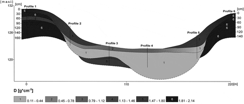
Table 1 Basic soil physical properties and content of sand, silt and clay in mineral horizons of soils in the research toposequence
Porosity of the superficial horizons in organic soils is two or three times greater than in ochric horizons in mineral soils. Increased porosity is also characteristic for deluvial horizons (36.64% in profile 2; 34.73% in profile 5) in contrast to ochric horizons in profile 1 and 6 (respectively: 26.72%, 31.18%).
3.3. Air-water properties of soils
The proportions of individual phases vary, indicating different soil formation histories (). In ochric horizons of sandy soils (profile 1), the contribution of the liquid and gas phases (13%) is small compared to that of the solid phase (73%). This profile is the driest of all soils in the toposequence. Soil moisture is increased in the deposition zone, because of the influence of ground water level and, as an effect, some species composition changes of plant cover occur from drier plant communities of Arrhenatherion on the slopes, to wet meadows of the alliance Calthion palustris in the bottom of the examined closed basin. In deluvial soils with buried horizons of organic soils, moisture is greater than in other superficial horizons and is also increased when coming down in the soil profile. High porosity of superficial A horizons in Colluvic Regosols creates more optimal and beneficial air conditions than in soils in the upper parts of the slopes.
Figure 4 Proportions of solid, fluid and gas phase in soil horizons. a.s.l., above sea level.
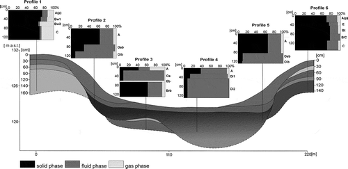
In all peat soils (profile 3 and 4) including buried peat soils, the content of water is high (83–91%) with a small contribution of the solid and gas phases. This results from their intrinsic properties and groundwater influence. Soils in the bottom of the study area are also much wetter because of the flora, which prevents direct evaporation from the field.
Distribution of total water resources to a depth of 130 cm in soils included in the toposequence depends mainly on location on the slope and soil type. Significant water resources (up to 12153.47 mm in profile 4) are characteristic for organic soils—Fibric Histosol (Drainic) and Sapric Histosol (Novic), including buried organic horizons at the bottom of Colluvic Regosols. Noticeable increase of water resources takes place in the contact zone between slopes and bottom of the research area. In A horizons of Colluvic Regosols (profile 2 and 5), water content is 4–6 times greater than in ochric horizons in profile 1 and 6.
4. DISCUSSION
The area of deluvial soils in a young glacial landscape in northwestern Poland is increasing because of soil erosion and improper agrotechnical practices. The undulating shape of the slopes under study causes deposition of eroded mineral material at their bases. Due to inhibition of energy transport, redeposition of this material and backfilling of the primary soil cover occur. In buried peat soils located near the slopes, the main pedological process is inhibited. In spite of the significant depth of deluvial horizons, there is no observable truncation of soils in higher parts of the slopes. It is therefore difficult to determine the genesis of these sediments and discern the role of natural and anthropogenic factors in redeposition processes. It can be concluded that the presence of complete soil profiles in the degradation zone is a result of strong but uniform slope processes (Świtoniak Citation2011). On the grassland slopes, there is no erosion at present. Meadow vegetation offers protection against the degrading impact of heavy rainfall events. Changes of bulk density, soil morphology and air-water properties of soils in closed basins are relatively permanent, despite land use modifications. Much research has shown that tillage has an influence on physical and chemical soil properties (Roseberg and McCoy Citation1992; Lipiec et al. Citation2006; He et al. Citation2009).
The soil compaction phenomenon is strongly noticeable in areas of intensive mechanized tillage (Soane and van Ouwerkerk Citation1994). This crucial problem of contemporary agriculture has an impact on plant growth. Compaction usually alters soil properties by increasing soil bulk density, which in turn affects decreasing soil porosity, aeration and infiltration capacity (Kozlowski Citation1999). Soils in the research toposequence are not strongly compacted, despite the fact that this area was used for a long time as a crop field. Bulk density differences between horizons of agricultural soils are not significant, which is often observed by other researchers (Drewnik et al. Citation2010). A decades-long restoration period has led to recovery of the superficial horizons. Discontinuation of tillage and the appearance of meadow vegetation in the closed basin initiated the period of soil conservation. Features of abandoned agricultural soils (profile 1 and 6) have been preserved in soils profiles until today. This applies particularly to characteristics of distinct transitions from the ochric and deeper horizons in profile 1 and 6. In historical tillage, one of the basic tools used was a plow. This technique was not so invasive as are contemporary ones. For this reason, abandoned soils in the research catena were not strongly compacted. On the other hand, the past methods of cultivation of soils caused intensification of natural slope processes. As a result of anthropogenic and natural factors, total area of deluvial soils was increasing and forming a continuous surface around the bottom of the closed basin. The zone between slopes and the bottom was not used for agriculture, because of difficult terrain conditions. As a consequence, Colluvic Regosols (profile 2 and 5) are not transformed by the interaction of human activity and characterized by optimal air-water conditions and other basic physical properties (Baužienė et al. Citation2008; Świtoniak Citation2011). Enriched deluvial A horizons in clay and silt arise as an effect of soil erosion, and anthropogenic denudation is common, especially in undulated landscapes (Mahaney and Sanmugadas Citation1989; Bieniek Citation1997; Piaścik and Sowiński Citation2002; Chodak et al. Citation2005; Smolska Citation2008; Sowiński and Lemkowska Citation2009).
Basins without outlets are common land forms in the young glacial landscape of northern Poland and represent a significant link in the cycle of matter and elements. For this reason, to protect the soil cover and geodiversity in closed basins, it is necessary to implement appropriate agrotechnical practices. Based on contemporary research on methods of tillage, no-till farming is one of the best methods of cultivation, in that it is the most non-invasive and protective against soil erosion (Pagliai et al. Citation1994; McGarry et al. Citation2000).
ACKNOWLEDGMENTS
This paper presents results obtained as part of the project “Changes of properties of basins without outlets in the young glacial landscape as a result of anthropogenic denudation and erosion.” This project has been supported by the Polish Ministry of Science and Higher Education (Research Project No. N N305 056240).
REFERENCES
- Baužienė I, Świtoniak M, Charzyński P 2008: Properties of deluvial soils in Poland and Lithuania and propositions for their classification. Žemės Ûkio Mokslai. 15/3, 29–35.
- Bieniek B 1997: Właściwości i rozwój gleb deluwialnych Pojezierza Mazurskiego. Acta Academiae Agriculturae ac Technicae Olstenensis. 64, 1–81. (in Polish).
- Bork HR, Lang A 2003: Quantification of past soil erosion and land use/land cover changes in Germany. Lecture Notes Earth Sci. 101, 231–239.
- Chodak T, Kaszubkiewicz J, Tasz W 2005: Skład granulometryczny i zawartość makroskładników w materiale glebowym zmywanym w wyniku erozji powierzchniowej. Acta Agrophysica. 5(3), 577–587. (in Polish).
- Drewnik M, Kacprzak A, Maziarka N 2010: Characteristics of post-agricultural soils in the former village of Caryńskie. Roczniki Bieszczadzkie. 18, 205–216. (in Polish, abstract and summary in English).
- FAO 2006: Guidelines for Soil Description. Food and Agriculture Organization of the United Nations, Rome.
- He J, Wang Q, Li H, Tullberg JN, McHugh AD, Bai Y, Zhang X, McLaughlin NB, Gao H 2009: Soil physical properties and infiltration after long-term no-tillage and ploughing on the Chinese Loess Plateau. New Zealand J. Crop Hortic. Sci. 37(3), 157–166.
- Klimowicz Z 1993: Zmiany pokrywy glebowej w obszarze utworów lessowych i lessowatych w zależności od okresu użytkowania i rzeźby terenu. Rozprawy Wydziału BiNoZ UMCS. 47, 90 pp. (in Polish).
- Kozlowski TT 1999: Soil compaction and growth of woody plants. Scand. J. For. Res. 14, 596–619.
- Kłysz P 1990: Mechanizm kształtowania się strefy marginalnej fazy pomorskiej na obszarze Pojezierza Drawskiego. UAM Seria Geografia. 47, 1–236. (in Polish).
- Lewandowski J, Heliasz Z, Chybiorz R 2006: Objaśnienia do Szczegółowej mapy geologicznej Polski 1:50 000, ark. Łubowo (197). Centralne Archiwum Geologiczne Państwowego Instytutu Geologicznego, Warszawa. (in Polish).
- Lipiec J, Kuś J, Słowińska-Jurkiewicz A, Nosalewicz A 2006: Soil porosity and water infiltration as influenced by tillage methods. Soil Tillage Res. 89, 210–220.
- Mahaney WC, Sanmugadas K 1989: Late-holocene soil toposequence in stroud basin central wind river mountains, western Wyoming. Geografisk Tidsskrift. 89, 58–65.
- Major M 2008: Morphometric differences among basins without outlets in the southern and central parts of the Parsęta catchment. Limnological Rev. 8(1–2), 43–49.
- Maksiak S, Mróz W 1978: Czwartorzęd środkowej części Pojezierza Pomorskiego. In: Z badań czwartorzędu w Polsce, 19. Biuletyn Instytutu Geologiczne. 300, 97–152. (in Polish).
- Matuszkiewicz W2001: Przewodnik do oznaczania zbiorowisk roślinnych Polski. PWN, Warszawa (in Polish).
- McGarry D, Bridge BJ, Radford BJ 2000: Contrasting soil physical properties after zero and traditional tillage of an alluvial soil in the semi-arid tropics. Soil Tillage Res. 53, 105–115.
- Orzechowski M, Smólczyński S 2010: Air-water properties of alluvial and deluvial soils in various landscapes of north-eastern Poland. Polish J. Soil Sci. XLIII/2, 103–113.
- Pagliai M, Raglione M, Panini T, Maletta M, La Marca M 1994: The structure of two alluvial soils in Italy after 10 years of conventional and minimum tillage. Soil Tillage Res. 34, 209–223.
- Paluszek J 2010: Zmiany pokrywy glebowej pod wpływem erozji. Prace i Studia Geograficzne. 45, 279–294. (in Polish).
- Piaścik H, Sowiński P 2002: Wpływ denudacji antropogenicznej na rozwój gleb obniżeń śródmorenowych krajobrazie Pojezierza Mazurskiego. Zeszyty Problemowe Postępów Nauk Rolniczych. 487, 249–257. (in Polish).
- Prusinkiewicz Z 2004: Roztwór glebowy i jego ekologiczne znaczenie. In Badania ekologiczno-gleboznawcze, Eds. Bednarek R, Dziadowiec H, Pokojska U, Prusinkiewicz Z pp. 234–241. Wyd. Nauk. PWN, Warszawa. (in Polish).
- Quine TA, Walling DE, Chakela QK, Mandiringa OT, Zhang X 1999: Rates and patterns of tillage and water erosion on terraces and contour strips: evidence from caesium-137 measurements. Catena. 36, 115–142.
- Roseberg RJ, McCoy EL 1992: Tillage and traffic-induced changes in macroporosity and macroporosity community: air permeability assessment. Soil Sci. Soc. America J. 56, 1261–1267.
- Smolska E 2008: Badania sedymentologiczne współczesnych osadów deluwialnych i ich znaczenie w ocenie dynamiki procesów erozji gleby na przykładzie Pojezierza Suwalskiego. Przegląd Naukowy Inż. i Kształtowanie Środowiska, Wyd. SGGW Warszawa, 17. 2(40), 202–212. (in Polish).
- Smólczyński S, Orzechowski M 2010: Distribution of elements in soils of moraine landscape in Masurian Lakeland. J. Elementology. 15(1), 177–188.
- Soane BD, van Ouwerkerk C Eds 1994: Soil compaction in crop production, Developments in Agricultural Engineering Series, 11. Elsevier Science, Amsterdam, Netherlands.
- Sowiński P, Lemkowska B 2009: Toposequence and soil properties in the landscape of ground moraine of Olsztyn Lakeland. In Soils of chosen landscapes, Ed. Bieniek B pp. 21–36. Department of Land Reclamation and Environmental Management, University of Warmia and Mazury in Olsztyn.
- Thapa BB, Casel DK, Garrity DP 1999: Assessment of tillage erosion rates on steepland Oxisols in the humid tropics using granite rocks. Soil Tillage Res. 51, 233–243.
- Turski R, Paluszek J, Słowińska-Jurkiewicz A 1991: Wpływ rzeźby terenu na stopień zerodowania i właściwości fizyczne gleb lessowych. In Erozja gleb i jej zapobieganie, Eds. Mazur Z, Pałys S, Grodzieński W, pp. 47–62. Wyd. AR, Lublin. (in Polish).
- Świtoniak M 2011: Przekształcenia pokrywy glebowej obszarów wysoczyznowych Pojezierza Brodnickiego w wyniku oddziaływania denudacji antropogenicznej. In Wybrane problemy genezy, systematyki i ochrony gleb regionu kujawsko-pomorskiego, Ed. Jankowski M PTSH Wrocław, PTG Warszawa. (in Polish).