
Abstract
This research was carried out in the locality of Dubljani in Popovo Polje, which is one of a series of typical Dinaric karstic poljes situated within the Mediterranean part of Bosnia and Herzegovina. Previous research has shown that the Mediterranean part of Bosnia and Herzegovina has the largest surplus and deficit of water at the same time. Because of this, we wanted to explore how much of the water goes to drainage runoff, and then how slope affects the surface runoff. The ultimate goal was to find a way to conserve water and prevent erosion in these natural conditions. Precipitation, drainage runoff, surface runoff and soil erosion were measured at the agro-hydrological station during the experimental period with the goal of understanding the problem of water erosion intensity. In order to study the relationship between precipitation and drainage runoff, six lysimeters with different soil depths were installed (1.3 m, 1.0 m, 0.5 m, 0.3 m and one karst simulation). In addition, six metal cassettes were set up and filled with the same soil used by the lysimeters to simulate inclinations of 1, 5 and 10%, involving both bare and grass-covered soil (Lolium perenne L., Poa pratensis L., Festuca rubra var. fallax Thuill., Dactylis glomerata L., Trifolium repens L., Trifolium pratense L.), and the total water runoff and soil erosion were monitored. The results indicate large differences in the agro-hydrological budget between bare rocky soil and loamy-clayey soils of different depths. The drainage runoff coefficient during the first year ranged from 0.33 in deep soil to 0.50 in shallow soil, while in the second year it ranged from 0.38 to 0.58. The results of the drainage runoff coefficient for the bare karst was higher than 0.70 during both years. The results of the measurement of the total surface runoff and soil erosion indicate that the impact of inclination can be mitigated by grass cover. The surface runoff measurements during the 2 years for both bare and covered soil at the same inclinations show a reduction in the surface runoff from 32 to 86%. The reduction of erosion in covered soil compared to bare soil ranged from 55 to 75%in the first year, while in the second year, erosion in the covered soil was almost completely stopped (a reduction of > 95%). This study shows a huge impact of soil cover on the agrohydrological budget where runoff potential increases with soil depth. Moreover, the results confirm the role of vegetation role in reducing runoff and soil erosion, which is important for better conservation of moisture in the soil. In future research, attention should be paid to the seasonal character of erosional processes.
1. INTRODUCTION
The southern part of Bosnia and Herzegovina (B&H) is characterized by karstic features and a Mediterranean climate. Lack of surface water, shallow soils and scarce vegetation are the most prominent natural characteristics of karstic areas. Soil erosion poses a serious environmental and social challenge around the world (Pimentel et al. Citation1995; Pimentel Citation2006), and the Mediterranean region is recognized as extremely endangered by soil degradation processes—soil erosion in particular (CEC Citation2006; Bou Kheir et al. Citation2008). Susceptibility to erosion is an effect of climate characteristics related to long dry periods followed by periods of rain (very often heavy, torrential downpours), which, in combination with terrain inclination and shallow, delicate soils, can cause enormous negative effects (Grimm et al. Citation2002). In addition to these natural conditions, numerous inadequate anthropogenic activities aggravate the described processes.
Such conditions require a good understanding of the agro-hydrological properties of the soils, from both production and environmental viewpoints. The agro-hydrology of the B&H karst regions has been poorly researched, and the majority of the conducted studies were actually commissioned by specific projects and for the identification of the best land reclamation solutions (Čustović and Hakl Citation2003). When it comes to soil erosion research in B&H, there is a lack of research addressing soil erosion in general, and particularly in the karst areas. The most significant studies in the area of soil erosion were carried out during 1979–1985, when the soil erosion map was developed for all of B&H. The map was developed by forestry engineers and thus, it was tailored to meet their specific needs; however, all copies of the map were destroyed during the B&H war (1992–1995). Recently, an innovated erosion map was developed for the Republika Srpska area (Tošić and Hrkalović Citation2009), as well as an assessment of potential erosion using the Universal Soil Loss Equation (USLE) method (Tošić et al. Citation2011). Also, several professional papers about soil erosion were published. Čavar (Citation1998) gave an overview of the natural conditions for the development of erosional processes in B&H and analyzed the climate, soil, vegetation cover, relief, geological substrate and water. The condition of erosion in B&H was classified into five categories, and it was concluded that B&H has a relatively moderate intensity of erosional processes. The same author (Čavar Citation2007, Citation2008) gave an overview of soil erosion research in the world and in B&H, with special interest paid to the organization of research studies in pilot basins and on experimental plots. The great need for research of this kind in B&H was emphasized because of its natural predisposition for the development of erosion processes (due to being a predominantly hilly-mountainous country).
The objective of this study was to obtain quantitative data that could help in carrying out the actions for proper land management in B&H’s Mediterranean karst regions. Previous research has shown that B&H’s Mediterranean karst area receives the largest amounts of precipitation in all B&H, but at the same time it shows a water deficit (Vlahinić et al. Citation2002; Čustović Citation2005). The role of vegetation in the mitigation of water erosion has long been known (Kosmas et al. Citation1997; Quinton et al. Citation1997; Cai et al. Citation2011; Peng and Wang Citation2012). Vegetation reduces erosion by protecting the soil from raindrops, increasing infiltration, reducing surface runoff and stabilizing the soil around the roots (Zachar Citation1982; Cai et al. Citation2011). Given these facts and because of an extremely variable rainfall regime we wanted to explore how much of the water goes to drainage runoff, and how slope affects surface runoff in different vegetation cover conditions by measuring precipitation, drainage runoff, surface runoff and soil erosion.
2. MATERIALS AND METHODS
2.1. Research area
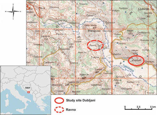
The Dubljani site, at which this research was carried out, is situated in Popovo Polje, one of a series of typical Dinaric karst poljes. Popovo Polje extends into the southernmost part of B&H at an elevation of 220–250 m and is only 10–15 km away from the Adriatic Sea (). The polje’s margin is built of carbonate rocks, mainly from the Mesozoic Era, whereas the polje’s floor consists of younger Quaternary deposits of considerable thickness. The polje’s sides descend relatively steeply down to the polje itself, which is very important from the viewpoint of runoff and leaching.
Figure 1 Location of study site.
The polje’s climatic characteristics are considerably influenced by the proximity of the Adriatic Sea; hence, this region is very rich in precipitation. According to data from the Federal Hydrometeorological Institute (FHMI) of B&H, 1958 mm is the 48-year average for Ravno, and only 11% of the total mean annual precipitation occurs from June to September. At the same time, the mean annual air temperature (50-year average), measured at the Trebinje meteorological station, reaches 14°C, with an annual maximum of 16°C and an annual minimum of 11°C. It should be noted that this region has very pronounced surpluses of water [the mean annual water surplus with readily available water (RAW) = 100 to 1285 mm] and that 67% of the rainfall received by the soil goes into runoff (Čustović Citation1994).
In the area of Popovo Polje, the following types of soil are found [according to the World Reference Base for Soil Resources (WRB) classification (IUSS Working Group WRB Citation2006)]: Fluvisols, Lithic Leptosol, Mollic Leptosol, and Cambisols (Calcaric and Rhodic).
2.2. Methods
The research was carried out during two consecutive years at the experimental agro-hydrological station in Dubljani (), Popovo Polje, where lysimeters of 1.7 m3 in volume, 1.2 m in diameter, 1.5 m in depth and a total area of 1.13 m2 were installed. The lysimeters were buried and connected to drainage runoff control measuring devices. They were set up in an uninterrupted sequence and compensation chambers for measuring the drainage runoff were placed at a lower elevation, so that the drainage water flowed into the compensator by free-fall. Six lysimeters were installed (), and using the Turc method (Turc Citation1961), they were filled with soil of different depths and stratigraphy ():
Figure 2 Sketch of Dubljani agro-hydrological station.
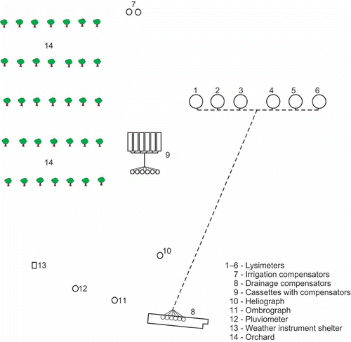
Figure 3 Stratigraphy of installed lysimeters.
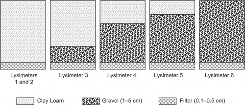
two lysimeters—very deep fluvisol (1.3 m)
one lysimeter—deep fluvisol (1.0 m)
one lysimeter—shallow fluvisol (0.5 m)
one lysimeter—very shallow fluvisol (0.3 m)
one lysimeter—bare karst, without fine soil
On five of the lysimeters (Lysimeters 1–5, ), we conducted research related to water consumption in mixed-species grass (Lolium perenne L., Poa pratensis L., Festuca rubra var. fallax Thuill., Dactylis glomerata L., Trifolium repens L., Trifolium pratense L.) under non-irrigation conditions, while Lysimeter 6 represented an imitation of bare karst. The water input into the lysimeters through precipitation was measured continuously by a pluviometer, and the output (drainage runoff) was controlled by a compensator.
For the purpose of measuring the surface runoff and soil erosion, a block consisting of six metal cassettes, 1 m2 (2 × 0.5 m) each, filled with the same soil as the lysimeters, was installed on the site (). Soil depth in the cassettes was 0.2 m. The bottom of the cassettes is open with filtering the same as in the lysimeters. The cassettes were used to create three different inclinations: 1%, 5% and 10%. For each inclination there were two cassettes, one with a grass cover and the other with bare soil. The bare soil was regularly weeded and kept tilled. Each cassette was individually connected to a compensator, where the amounts of surface runoff and deposits were measured. An aliquot of water and deposit suspension was taken from each compensator to the laboratory where, after filtration and drying, we obtained data on the quantity of the deposit per runoff water from the unit’s area. Hence, we obtained data on the quantity of the eroded deposit on 1 ha, for each variant of the trial.
The composition of the mixed-species grass planted in the lysimeters and cassettes for measuring the runoff was as follows: perennial ryegrass (Lolium perenne L.) (40%), common meadow grass (Poa pratensis L.) (10%), red fescue (Festuca rubra var. fallax Thuill.) (10%), white clover (Trifolium repens L.) (10%), red clover (Trifolium pratense L.) (5%), and cocksfoot (Dactylis glomerata L.) (25%). The height of the grass in the lysimeters and cassettes for runoff measurement was kept at 5–8 cm for the purpose of achieving better rooting and texture.
Additionally, a meteorological block comprised of a pluviometer, thermohygrograph, minimum and maximum wet thermometer, dry thermometer and heliograph was set up.
3. RESULTS
3.1. Results of the meteorological measurements
The data gathered through the meteorological measurements indicate that maximum precipitation occurs from fall to spring and that summers are mainly dry. During the first hydrological year (the measurements started in October, when the wetter part of the year starts), the recorded precipitation level amounted to 1512 mm, which was 365 mm more than in the second hydrological year. Compared to the Ravno measuring station’s multi-year average, a reduction in precipitation was recorded: 446 mm in the first year and 811 mm in the second year.
The maximum air temperatures were recorded in July and August, and the minimum in January and December. The average temperature during the first year was 14°C and 15°C during the second year, which is an insignificant deviation from the multi-year average.
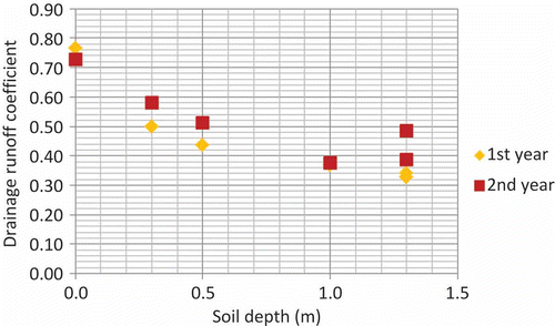
3.2. Lysimetric measurements—measurement of the drainage runoff
During the first hydrological year, a total of 1512 mm precipitation was recorded at the Dubljani site. The measurements of the drainage runoff indicate huge differences, primarily between the bare karst (Lysimeter 6) and the loamy-clayey soils (Lysimeters 1–5), but also between the loamy-clayey soils of different depths (). The highest amount of runoff, at 1158 mm, was recorded in bare karst, while in the loamy-clayey soils it ranged from 494 to 754 mm.
Table 1 Drainage runoff for 6 lysimeters with different soil depths
During the second hydrological year, a total of 1146 mm of precipitation was recorded; hence, the results of the drainage runoff measurements show lower levels relative to the first hydrological year, except for Lysimeter 2 (deep soil) where the runoff level was 62 mm higher. The exception we recorded in Lysimeter 2 could be caused by two reasons. The first is slow water percolation during intense rainfall when water spilling over from the lysimeters may occur. The second reason may be the vertical plunge of the first rainfall through the cracks formed during the dry period. In Lysimeters 1–5 (the lysimeters with soil), the drainage runoff coefficient from the first hydrological year ranged from 0.33 in deep soil to 0.50 in shallow soil, while in the second hydrological year it ranged from 0.38 to 0.58. The drainage runoff coefficient in the bare karst was higher than 0.70 during both hydrological years ().
Figure 4 Coefficient of drainage runoff – relationship between drainage runoff and depth of soil in the lysimeters.
3.3. Measurement of the surface runoff
The cassettes were aimed at examining how much of the precipitation goes into runoff and the level of erosion (deposit) it could cause. Measuring the surface runoff began somewhat later than measuring the precipitation and drainage runoff (vertical percolation) in the lysimeters, as we wanted the soil in the cassettes to settle and consolidate. In both hydrological years, higher levels of runoff were recorded in the bare soil compared to the covered soil, and in all three inclinations of the soil ().
Table 2 Surface runoff and soil erosion for bare and covered soil at inclinations of 1%, 5% and 10%
The increase in the inclination of the bare soil was noted to be related to the increase in the runoff level during both hydrological years, and the bare soil runoff levels were uniform during both hydrological years (in the first year they ranged from 127 to 187 L m−2, and in the second year from 151 to 204 L m−2).
In the covered soils, the runoff levels also increased with the increase in inclination during the second hydrological year, while during the first year there was a deviation, so the highest level of runoff occurred with the 5% inclination. The reason for this could be an error (water spillover from the cassette, etc.); however, this has not been confirmed in the field.
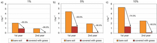
3.4. Measurement of soil (deposit) erosion
The soil erosion level during the 2-year period ranged from 0.90 to 5.30 t ha−1 in bare soil, and from 0.04 to 1.30 t ha−1 in covered soil ().
During the first hydrological year, the largest deposit from the bare soil was recorded at a 10% inclination: it amounted to 5.30 t ha−1, which is 2.70 times more than at a 1% inclination. At the same time, the rooting of the grass species that were planted led to a significant reduction of deposits in the covered soil. The deposits from the covered soil in relation to the bare soil were 1.10 t ha−1 smaller at the 1% inclination, 3.10 t ha−1 at the 5% inclination and 3.90 t ha−1 at the 10% inclination.
During the second hydrological year, there was a significant reduction of deposits at all inclinations and in both trial variants (bare and covered soil), and erosion on the covered soil was almost completely stopped. In the case of the bare soil, the level of erosion ranged from 0.90 t ha−1 at the 1% inclination to 2.50 t ha−1 at the 10% inclination. Soil erosion on the covered soil compared to the bare soil was lower by 25, 32 and 22 times for the 1%, 5% and 10% inclinations, respectively.
4. DISCUSSION
Because agriculture is a very important branch of the economy in the Mediterranean part of B&H, understanding the soil’s agro-hydrological characteristics is a priority. The results clearly indicate that soil depth and the mechanical composition of the soil have a huge impact on the agro-hydrological budget. Generally, the drainage runoff potential increases with decreasing soil depth. In deep soils, the drainage runoff averages 33% of the total precipitation, while in the bare karstic areas this level rises to > 70%.
The experiment with the cassettes was conducted to investigate the effects of inclination on amounts of surface runoff and soil erosion for both the bare and covered soils.
It is well known that climatic characteristics (rainfall regime, mainly), type of land use and soil cover have a critical influence on surface runoff and soil erosion (Kosmas et al. Citation1997; Calvo-Cases et al. Citation2003; Peng and Wang Citation2012), which is confirmed by the results obtained in this research.
The results of the surface runoff measurements during the two hydrological years for both bare and covered soil, at the same inclinations, indicate some significant differences (). The reduction of the surface runoff ranged from 32 to 86%. A significant reduction in the runoff from the covered soil compared to bare soil, recorded during the second hydrological year, was an effect of the rooting of the planted grass mixtures. Although the aim of this paper was to compare the runoff and erosion process on bare and covered soil, it should be noted that despite the smaller amount of rainfall during the second hydrological year (about 75%), the surface runoff on the bare soil was similar to or higher than during the first hydrological year, and on the covered soil it was less. The positive influence of vegetation is even more clearly observed when measuring the amount of soil erosion. During both hydrological years, the erosion level was higher in the bare than in the covered soil, in all inclination variations (, ).
Figure 5 Surface runoff during 2 hydrological years for bare and covered soil at (a) 1%, (b) 5% and (c) 10% inclinations.
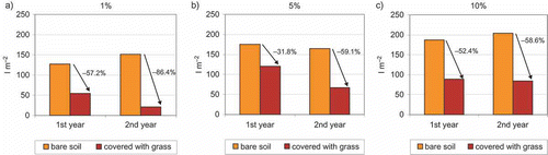
Figure 6 Soil erosion during 2 hydrological years for bare and covered soil at (a) 1%, (b) 5% and (c) 10% inclinations.
For the 18-month period during which the surface runoff was measured, the coefficients of the surface runoff were calculated for the bare and covered soil and for all inclination variations (1%, 5% and 10%). The runoff coefficient in the bare soil was higher than in the covered soil at all inclinations. During the analyzed 18-month period, out of the total precipitation (1938 mm), the surface runoff from the bare soil at the 10% inclination amounted to 20%, while from the covered soil at the same inclination it amounted to 9% (). The results of the measurements indicate a significant effect of grass cover on the reduction of runoff, which has a direct relationship with the soil erosion processes.
Table 3 Coefficient of surface runoff at different inclinations (18 months)
The soil erosion measurements indicate the extent to which surplus runoff causes soil erosion at different inclinations but under the same other conditions over two hydrological years. Kosmas et al. (Citation1997) stated that in areas receiving > 700 mm precipitation annually, soil loss can generally range from 15 to 90 t km−2 (0.15 to 0.90 t ha−1) per year (their research was conducted on soils planted with grain crops), which was achieved in the covered soil monitored during this research. However, during our second year the levels of soil loss were lower than the above-mentioned ones.
The reduction of erosion in the covered soil compared to bare soil during the first year ranged from 55 to 75%, while during the second hydrological year, the erosion in the covered soil almost completely stopped (a reduction of > 95%). At the 10% inclination, erosion was from 2.5 t ha−1 in the bare soil to 0.1 t ha−1 in the covered soil. These results are consistent with the research on the impact of vegetation on erosion reduction conducted in the karstic areas of China, where Zhang et al. (Citation2004) recorded a reduction of erosion from 53–256 to 2–43 t ha−1 year−1, and Cai et al. (Citation2011) recorded a reduction of erosion between 65 and 90% in cases where 40% of the soil was covered by vegetation.
5. CONCLUSION
Lysimetric measurements were needed to determine how much water goes into drainage runoff in natural conditions, which is especially important for decision-making under the condition of variable rainfall regimes, as in the Mediterranean part of B&H. The results clearly indicate that soil has a huge impact on the agro-hydrological budget and that, generally, the runoff potential increases as soil depth decreases. Climatologically, the study area is characterized by periods with greater rainfall in the colder part of the year (late fall and winter) and by periods with less rainfall in the warmer part of the year (late spring and summer). The results of this study enable decision-making about where and when (in which part of the year) to favor drainage runoff and the rapid evacuation of surplus water from the soil, and where and when to slow down the evacuation in order to conserve water and increase the soil’s evapotranspirational potential.
The results confirm the well-known role of vegetation in reducing runoff and soil erosion. The grass cover showed a very strong impact on the reduction of surface runoff (from 32 to 86%), which not only directly reduced soil erosion (55–75% in the first year and > 95% in the second), but also enabled the better conservation of moisture in the soil. For this reason, maintenance of the cover on soil with an incline of up to 10% is recommended as a compulsory erosion control action. Additionally, contour plowing—that is, plowing on the contourlines/isohypses—is also a requirement.
The soils in the research area are most exposed to erosion from autumn to spring, which is when this area receives the greatest amount of precipitation. In this context, in all future research and during the implementation of erosion control measures, special attention should be paid to the seasonal character of these processes.
REFERENCES
- Bou Kheir R, Abdallah C, Khawlie M 2008: Assessing soil erosion in Mediterranean karst landscapes of Lebanon using remote sensing and GIS. Eng. Geol., 99, 239–254.
- Cai X, Wang J, An Y, Dan W 2011: Laboratorial simulation on soil erosion under different vegetation coverage in southwest karst area, China. International Symposium on Water Resources and Environmental Protection (ISWREP), Volume 3, 2010–2014.
- Calvo-Cases A, Boix-Fayos C, Imeson AC 2003: Runoff generation, sediment movement and soil water behaviour on calcareous (limestone) slopes of some Mediterranean environments in southeast Spain. Geomorphology, 50, 269–291.
- Čavar B 1998: The conditions for the development of erosion processes and the state of erosion in Bosnia and Herzegovina. ANUBIH, Simpozij “Korištenje tla i vode u funkciji održivog razvoja i zaštiti okoliša,” Sarajevo (in Bosnian).
- Čavar B 2007: The scientific research in the field of soil erosion and runoff in the last century (Part I).Voda i mi, 57, 44–52 (in Bosnian).
- Čavar B 2008: The scientific research in the field of soil erosion and runoff in the last century (Part II). Voda i mi, 58, 45–54 (in Bosnian).
- CEC 2006: Thematic Strategy for Soil Protection, Communication COM (2006)231. http://eur-lex.europa.eu/LexUriServ/LexUriServ.do?uri=COM:2006:0231:FIN:EN:PDF (May, 2010).
- Čustović H 1994: Uticaj fizičkih svojstava tla na agrohidrološki bilans u području Bune i Popova polja (PhD thesis). University of Sarajevo, Sarajevo, Bosnia and Herzegovina (in Bosnian).
- Čustović H 2005: An overview of general land and soil water conditions in Bosnia and Herzegovina. In Soil Resources of Europe, second edition, Eds. Jones RJA, Houšková B, Bullock P, and Montanarella L, Pp. 73–82. European Soil Bureau Research Report No.9, EUR 20559 EN. Office for Official Publications of the European Communities, Luxembourg.
- Čustović H, Hakl Z 2003: Water regime of specific soils in Herzegovina. International Workshop: Sub-Mediterranean Fruit and Wine Growing, Mostar, Radovi Poljoprivrednog fakulteta Univerziteta u Sarajevu, 52 (in Bosnian).
- Grimm M, Jones J, Montanarella L 2002: Soil erosion risk in Europe. European Soil Bureau Research Report, EUR 19939 EN, Office for Official Publications of the European Communities, Luxembourg.
- IUSS Working Group WRB 2006: World reference base for soil resources 2006. World Soil Resources Reports No.103. FAO, Rome.
- Kosmas C, Danalatos N, Cammeraat LH et al. 1997: The effect of land use on runoff and soil erosion rates under Mediterranean conditions. Catena, 29, 45–59.
- Peng T, Wang S 2012: Effects of land use, land cover and rainfall regimes on the surface runoff and soil loss on karst slopes in southwest China. Catena, 90, 53–62.
- Pimentel D 2006: Soil erosion: a food and environmental threat. Environ. Dev. Sustain., 8, 119–137.
- Pimentel D, Harvey C, Resosudarmo P et al. 1995: Environmental and economic costs of soil erosion and conservation benefits. Science, New Series, 267(5201), 1117–1123.
- Quinton JN, Edwards GM, Morgan RPC 1997: The influence of vegetation species and plant properties on runoff and soil erosion: results from a rainfall simulation study in south east Spain. Soil Use Manage., 13, 143–148.
- Tošić R, Dragićević S, Kostadinov S, Dragović N 2011: Assessment of soil erosion potential by the USLE method: case study: Republic of Srpska – BiH. Fresenius Environ. Bull., 20(8), 1910–1917.
- Tošić R, Hrkalović D 2009: Innovation of erosion map of Republica Srpska. Voda i mi, 65, 54–66 (in Bosnian).
- Turc L 1961: Evaluation des besoins en eau d’irrigation, evapotranspiration potentielle. Ann. Agron., 12, 13–49 (in French).
- Vlahinić M, Čustović H, Alagić E 2002: Situation of drought in Bosnia and Herzegovina. International Conference of ICID, Bled Slovenia. “Drought Mitigation and Prevention of Land Desertification.”
- Zachar D 1982: Soil erosion. In Developments in Soil Science 10, Ed. Holý M, p. 548. Elsevier, New York.
- Zhang B, Yang YS, Zepp H 2004: Effect of vegetation restoration on soil and water erosion and nutrient losses of a severely eroded clayey Plinthudult in southeastern China. Catena, 57, 77–90.