
Abstract
The Soil and Water Assessment Tool (SWAT), a basin-scale hydrological and water quality simulation model, has become popular in Asia for assessing the impacts of land use and human activities including paddy rice (Oryza sativa L.) cultivation which is a typical agricultural management system in Asia. The water ponding and drainage management in paddy fields should significantly affect the regional hydrology and water quality; however, the suitability of SWAT for simulating paddy hydrology at a field scale has not been thoroughly examined.
In this study, the water balance of irrigated paddy fields in SWAT was examined for a small watershed where actual daily irrigation data were available. Two approaches available in SWAT to calculate hydrology in a watershed containing paddy fields, the curve number procedure and the pothole module, were applied with the regional paddy rice management standard.
The water balance components estimated using the pothole module were significantly different from the actual hydrology in paddy fields. The estimated percolation of water was zero on most days even under ponded water conditions. Any of the percolation, surface runoff and evapotranspiration (ET) was estimated to be zero during the drainage period. The estimated ET was too small on a number of days during the ponding period. As a result, the watershed-scale Nash-Sutcliffe model efficiency (NSE) for the daily river flow rate at the outlet of the watershed was less than zero, indicating low model efficiency. On the contrary, no significant problems were apparently found in the estimated water balance components in paddy fields using the curve number procedure, yielding a higher NSE value of 0.58 at the watershed scale. However, the curve number procedure that in principle cannot simulate the ponded water conditions is obviously impossible to use to reflect the various paddy water management scenarios in the field.
In conclusion, neither of these two approaches is suitable for simulating paddy field hydrology, indicating the need for the development of a paddy module in SWAT.
Key words:
1. INTRODUCTION
The Soil and Water Assessment Tool (SWAT) is a physically based, continuous time-step hydrological model used to predict the impact of land management practices on water, sediment and agricultural chemical yields in basins with various soil types, land uses and management conditions (Arnold et al. Citation1998). This model has widely been used in the United States and Europe (Gassman et al. Citation2007) and is becoming popular in Asia. In Asia, paddy rice (Oryza sativa L.) cultivation is a typical agricultural management system characterized by ponded water conditions in association with the irrigation and drainage systems.
Researchers in Asia (Tripathi et al. Citation2005; Behera and Panda Citation2006; Ouyang et al. Citation2008; Somura et al. Citation2009) have applied SWAT to watersheds containing paddy fields. These papers evaluated the performance of SWAT to predict the river water flow rate at the watershed scales. However, to our knowledge, there is no literature that shows the water balance of paddy fields based on the SWAT simulation. Even though a lot of researchers have applied SWAT to watersheds containing paddy fields, any verification focusing on paddy field hydrology has not been conducted. Therefore, the suitability of SWAT for watersheds containing irrigated paddy fields is still unclear.
There have been only a few advanced studies for applying SWAT in consideration of paddy field hydrology under ponded water conditions. Kang et al. (Citation2006) developed an algorithm which subtracts the daily mean percolation from ponded water to simulate the decrease of ponded water level in irrigated paddy fields. Xie and Cui (Citation2011) developed an algorithm to reproduce the paddy irrigation, in which the irrigation operation is implemented when the ponding depth decreased to a threshold depth. The ponding depth increases with irrigation up to the maximum ponding depth and decreases with evaporation and percolation down to the threshold depth. This simulated cycle of ponding depth appears to adequately reflect the actual ponding depth fluctuation in the field. However, this method cannot reflect the amount of actual daily irrigation water because the daily amount of water calculated by this cycle has no connection with the actual daily amount of water supplied through the irrigation canal. Nevertheless, the method developed by Xie and Cui (Citation2011) that estimates the amount of irrigated water based on the water consumption at fields is the best method in the cases in which a record of the daily amount of water supplied through the canal is not available.
Two paddy simulation approaches have been described in papers that used SWAT to assess the hydrology in a watershed containing paddy fields (Watanabe et al. Citation2013). The first is the curve number (CN) approach (Im et al. Citation2007; Jung et al. Citation2012) which applies the Soil Conservation Service (SCS) CN procedure developed by the National Resources Conservation Service (NRCS Citation2004) to calculate the rainfall-runoff response in paddy field hydrological response units (HRUs). In SWAT, HRUs are defined as the areas, each of which consists of homogeneous land use with homogeneous land management and soil characteristics, located in a sub-watershed. In this approach, the amount of runoff is calculated by the rainfall amount on a given day, the 5-d antecedent rainfall amount and the CN value of the land. The CN value is determined by the hydrological soil group, land use and land surface condition. This approach does not contain the water ponding process; therefore, its suitability for paddy fields is questionable. The second is the impounding approach (Kang et al. Citation2006; Xie and Cui Citation2011), in which water can be stored above the soil profile. The SWAT has a module called the “pothole module” which can be used for the impounding approach. This module allows water ponding in HRUs, as is the case in actual paddy fields. This module was originally designed and applied for pothole landscapes in the Corn Belt area (Du et al. Citation2005). The use of the pothole module to simulate paddy fields is recommended in the SWAT theoretical documentation (Neitsch et al. Citation2002). Although this module is recommended to be used for paddy fields, it was not developed for paddy fields and its suitability for paddy fields is not mentioned in the theoretical documentation. The advantage of the CN procedure is that there are a large number of studies available in the literature using this method, whereas few studies have applied the pothole module for paddy fields. The advantage of the pothole module is that the water ponding process is contained in the module. In previous studies, the applicability of these two approaches has been evaluated only at the sub-watershed and/or whole watershed scales, and the water balances of paddy fields have not been shown.
In this study, SWAT Citation2009 (ver. 488) was applied to a watershed containing irrigated paddy fields, and the suitability of the two common approaches available in SWAT was examined at the HRU scale to prevent abuse of SWAT without considering the water balance of paddy fields.
2. STUDY AREA
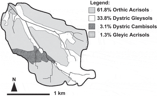
The study area was the Arata River watershed () in central Japan (latitude: 34°40´–34°42´N; longitude: 137°27´–137°30´E). The area was approximately 3 km2, of which 56.4% was upland fields and 18.0% was paddy fields (). The standard size of the paddy fields is about 30 m wide and 70 m long, and each paddy field was terraced and mostly faced toward drainage canals. According to the farmland soil map in 1992 (Takata et al. Citation2009), there are two primary soil types in the watershed: 61.8% of the area was classified as Orthic Acrisols and 33.8% was Dystric Gleysols ().
Figure 1 Location of the study watershed.
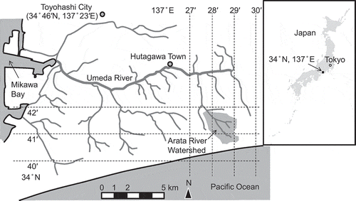
Figure 2 Land use in the study watershed (original figure from Sakaguchi et al. Citation2014).
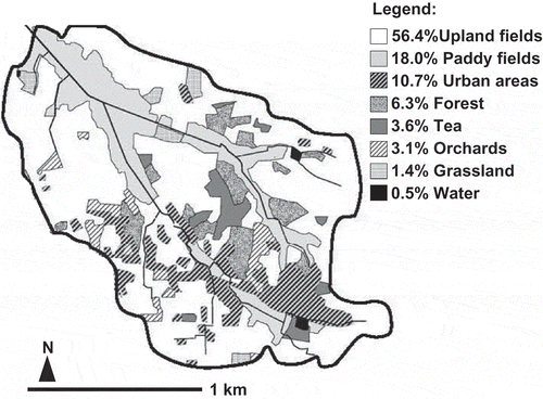
Figure 3 Soil distribution in the study watershed.
According to the Japan Agricultural Cooperative Toyohashi branch, the leading rice variety grown in the Arata River watershed is “Aichinokaori SBL”, and the farmers transplant these rice seedlings into the paddies. According to the farming calendar distributed by Japan Agriculture (JA Citation2010) for the study region, the puddling date was May 28, the transplanting date was June 1, the mid-season drainage period was from July 5 to 15 and the harvest date was October 10. In upland fields, tobacco (Nicotiana tabacum L.) is the major crop in summer, whereas cabbage (Brassica oleracea L. var. capitata) is the primary crop in winter.
The watershed rises from its minimum elevation of 35 m above sea level (asl) in the north to the maximum elevation of 75 m asl in the south, where the watershed is bordered by steep cliffs along the seashore. According to the soil data in the KuniJiban database of the Public Works Research Institute (PWRI Citation2008), the soil below 1 m in the watershed is gravelly sand. According to the weather records from nearby observatories (Hamamatsu, 21 km east from the Arata River watershed), the annual mean precipitation is 1809 mm, the annual mean maximum and minimum air temperatures are 20.5 and 12.8 °C, respectively, the annual mean relative humidity is 76%, the annual mean wind speed is 3.4 m s−1 and the annual mean solar radiation is 13.5 MJ m−2.
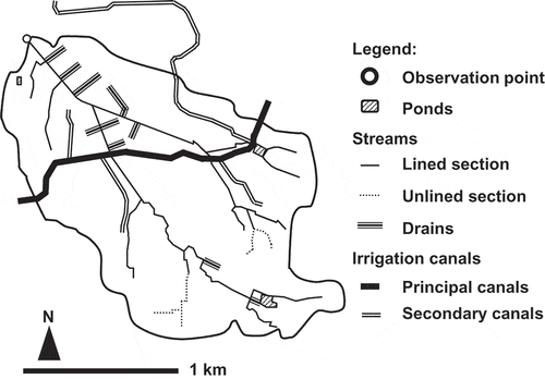
The Arata River watershed is a small watershed within a large-scale irrigation system named the Toyokawa irrigation system (). In general, in small-scale paddy irrigation, the paddy irrigation does not influence the annual river water discharge because irrigation water is derived from the limited water resources within the watershed. However, in large-scale irrigation systems, river water discharge is significantly influenced by paddy irrigation because irrigation water is additionally supplied from outside of the watershed. By this large-scale irrigation method, rice paddy fields yield a large amount of additional percolation and surface drainage water, resulting in a large increase in the river flow. illustrates the hydrological network of the watershed. The water in the Toyokawa irrigation canal flows from outside of the Arata River watershed via four secondary canals. These secondary canals are closed concrete pipelines that supply irrigation water to all paddy fields and to a large part of upland fields via taps and sprinklers, respectively. The amounts of water supplied through Toyokawa irrigation canal during the whole study period and the ponding period were equivalent to 29 and a 37%, respectively, of the total river water discharge from the Arata River watershed.
Figure 4 Schematic diagram of the paddy irrigation in the study watershed.
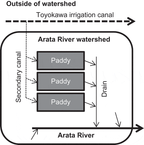
Figure 5 Hydrological network in the study watershed.
3. METHODOLOGY
The SWAT was applied to a small watershed containing irrigated paddy fields (the Arata River watershed). The hydrological process of paddy fields during the ponding period was estimated by two approaches: (1) the CN procedure and (2) the pothole module of SWAT. The hydrological processes of all HRUs other than the ponded paddy fields during the irrigation period were estimated by the CN procedure in both approaches.
The following input data are required: the soil physical properties database of Japan, daily irrigation data, the roughness coefficients for each land use, the growth parameters of each crop, the hydrological properties of the rivers and ponds, the validated warming period and the slope length of the paddy HRUs. Details of input data will be shown later. After the first simulation, the model was calibrated using the stream flow observed in the Arata River from October 2005 to September 2006. Then it was validated using the flow rates from October 2004 to September 2005.
3.1. Settings of the two approaches for irrigated paddy HRUs
In the CN approach, the value of curve number in average conditions (CN II) of the irrigated paddy fields was set to 82 which was reported by Im et al. (Citation2007) for their study paddy field. In the CN procedure, the rainfall-runoff is calculated by the following equation:
where Q = runoff depth (mm), P = rainfall depth (mm) and S = maximum retention storage (mm). The parameter S is related to the CN value by the following equation:
The CN value is a dimensionless index and is grouped to three antecedent moisture conditions. These three conditions are defined by 5-d antecedent rainfall amounts, as defined in NEH-4 (SCS Citation1972), and they are associated with CN I, II or III. CN I and CN III represent dry and wet conditions. The CN value of paddy field has not been explicitly defined. Therefore, Im et al. (Citation2007) determined the CN value of irrigated paddy fields based on the measured rainfall-runoff relationship and ponding depth. In their approach, the antecedent moisture conditions were defined not by the 5-d antecedent rainfall amounts but by the ponding depth of paddy fields, assuming that the time series data of ponding depths follows normal distribution and that the S value of paddy fields relies more on the ponding depth than on the antecedent rainfall. The CN value was determined using a procedure proposed by Hjelmfelt (Citation1980, Citation1991). The CN value of Im et al. (Citation2007) was adopted in this study, although the height of the check gate in their paddy fields is higher than that in the Arata River watershed. The paddy HRUs were irrigated using the daily irrigation canal flow rates, as described in Section 3.7, during the ponding period. The duration of the irrigation period was assumed to be from April 28 to October 3 according to the regional rice-farming calendar (JA Citation2010). In the winter drainage period from October 4 to April 27 and the mid-season drainage period from July 5 to 15, the surface runoff ratio of irrigation water (IRR_SQ) was set at 100% so that the water flowing through the paddy irrigation canal discharges directly into the stream. In the paddy HRUs, rice was cultivated from June 1 (transplanting) to October 10 (harvesting).
In the pothole approach, all paddy HRUs were set to the potholes and the fraction of the HRU area that drains into the pothole (POT_FR) was set to 100%. In the pothole module, all irrigation water and rainfall first flows into the pothole. Then, the ponded water in the pothole infiltrates into the soil layer, overflows into the stream, evaporates from the water surface or remains in the pothole under the impounded condition. According to Chapter 27.3 (Depressions/potholes) in the SWAT theoretical documentation (Neitsch et al. Citation2002), these processes are calculated as follows.
Seepage process (defined as infiltration from ponded water into soil surface in SWAT):
Overflow process:
Evaporation process:
where Vseep is the volume of water lost from the water body in the pothole by seepage (m3), KS is the effective saturated hydraulic conductivity of the first layer in the profile (mm hr−1), SA is the surface area of the water body in the pothole (ha), SW is the soil water content of the soil profile on a given day (mm), FC is the soil water content at field capacity (mm), Vflowout is the volume of water flowing out of the water body in the pothole during the day (m3), V is the volume of ponded water in the pothole (m3), Vpot,mx is the maximum amount of ponded water that can be stored in the pothole (m3), Vevap is the volume of water removed from the water body in the pothole by evaporation during the day (m3), LAI is the leaf area index of the plants growing in the pothole, LAIevap is the leaf area index at which no evaporation occurs from the water surface and E0 is the potential evapotranspiration (PET) for a given day (mm).
The pothole module has another condition, known as the released condition. In this condition, the rainfall is divided into the surface runoff and the percolation by the CN procedure. The maximum ponding water depth of the pothole (POT_VOLX) was set at 30 mm with reference to the regional rice-farming calendar. The pothole condition was set to be impounded during the ponding period and to be released during the drainage period. Then, the irrigation of the paddy HRUs, the surface runoff ratio of the irrigation water and the cultivation of rice were set in the same manner as in the CN approach.
3.2. Spatial data
The 10-m-mesh elevation data from the Digital Japan Web System (DJWS) of the Geospatial Information Authority of Japan (GSI Citation2010) was used as the digital elevation model (DEM) for the study area. The 1:2500 polyline river map from the DJWS was incorporated (“burned in”) into the DEM, and digital models of the streams were generated. The river polyline map included both small streams and paddy drains, of which flow directions have less relation with the topography. Such drains can guide the DEM-based digital stream models to incorrect directions; therefore, paddy drains were deleted from the polyline map before performing the burn-in. The farmland soil map in 1992 (Takata et al. Citation2009), which was in the form of polygon data categorized by soil series, was used as the soil layer for the Geographic Information System (GIS) (). The soils in the residential and forest areas were roughly estimated based on the relation between the soil type and topography in the watershed. The digital polygon map of land use was created from the 1:25,000 topographical map (GSI Citation2002), and it was used as the land use GIS layer ().
3.3. Soil properties
The SolphyJ (Eguchi et al. Citation2011) was used to provide the soil physical properties to the soil GIS layer. In SolphyJ, soil physical properties of the farmland in Japan are categorized by soil series, soil horizon and land use type (paddy fields, upland fields, orchards, grasslands and greenhouse fields). The importance of SolphyJ is that it contains soil physical property data of each soil horizon of different soil and land use types, including the data of low-permeability plowsole that generally occurs in paddy fields and strongly affects the percolation rate. In SolphyJ, Dystric Gleysols of paddy fields is composed of three soil layers, and the second layer is the plowsole. The depth of the bottom of the undermost soil layer is 540 mm.
The particle sizes of clay, silt, fine sand and coarse sand are defined as < 0.002, 0.002 to 0.02, 0.02 to 0.2, and 0.2 to 2 mm in SolphyJ. This definition is different from the United States Department of Agriculture (USDA) soil classification system that is used by SWAT; therefore, the particle size distribution in SolphyJ was converted to that in the USDA soil classification system by means of an empirical equation (Minasny and McBratney Citation2001). The available water capacity (AWC) was calculated using the van Genuchten equation (van Genuchten Citation1980), for which parameters were determined by fitting to the soil water content data in SolphyJ at matric suction values of 0, ‒3.1, ‒49, ‒1.6 × 10³ and ‒3.1 × 10⁴ kPa.
3.4. River and overland flow properties
The riverbank and bed materials were mostly concrete, and partially covered by sediments and algae. For the river water flow properties, the following data were set: the Manning roughness coefficient, the saturated hydraulic conductivity of the riverbank and bed, the width and depth from the bank to the bed, and the locations of three ponds. For the overland flow properties, the roughness coefficient was set for each land use () based on the data from Kadoya (Citation1980).
Table 1 Manning roughness coefficient for each land use adopted in this study
3.5. Weather data
The daily maximum and minimum air temperatures, relative humidity and wind speed data of the Hamamatsu observatory were obtained from the meteorological database of the Automated Meteorological Data Acquisition System (AMeDAS) (Japan Meteorological Agency Citation2011). The solar radiation data were obtained for the Nagoya observatory (70 km northwest from the study site) from the AMeDAS database. Precipitation was observed at 10-min intervals using a rain gauge (Model 6712, ISCO, Lincoln NE) installed at the outlet of the Arata River.
3.6. Crop evapotranspiration
The daily PET was computed based on the Penman-Monteith method (Monteith Citation1965) using the observed daily weather data. The potential transpiration was estimated as a function of PET and LAI. The LAI value was calculated using the daily heat unit accumulation and plant growth parameters in SWAT. The growth parameters of rice () and the other crops were set according to the farming calendars and available literatures of this region. All crops were set to be automatically fertilized because the aim was solely to examine water balances rather than nutrient balances.
Table 2 Growth parameters of rice (Oryza sativa L.) adopted in this study
3.7. Daily irrigation
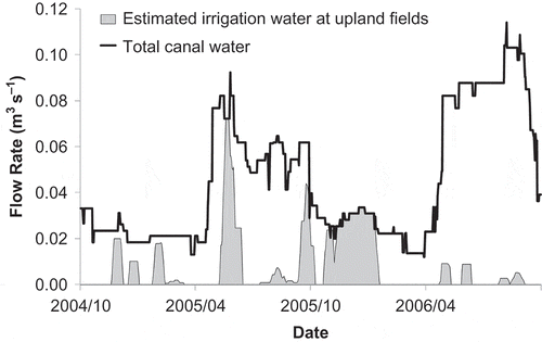
The Toyokawa irrigation canal which originates outside the Arata River watershed supplies irrigation water to the paddy fields and upland fields in the watershed. The total amount of daily water supply via this canal into the watershed was obtained from the records of the Japan Water Agency (JWA) Toyokawa office. The canal water is distributed simultaneously to the paddy and upland fields; therefore, the amount of water irrigated at the upland fields was calculated using the method to estimate the daily water consumption described by the Food and Agriculture Organization (FAO Citation1998a). As the calculated daily irrigation at the upland fields sometimes exceeded the total amount of daily canal water flow, daily irrigation at the upland fields was assumed to be conducted by the farmers before the onset of crop water stress so that the watershed-scale water consumption is consistent with the actual daily canal flow. The rest of the canal flow water, which was not irrigated at the upland fields, was assumed to be supplied to the paddy fields.
shows the flow rates of the total canal water and the estimated irrigation water at the upland fields. The estimated irrigation amount at the upland fields was 131 mm y−1 on average, a value which is comparable to the regional standard irrigation amount of 150 to 200 mm y−1 (Yamada et al. Citation2003). The estimated amount at the paddy fields during the rice-farming period was 1608 mm, a value which is comparable to the officially designated amount of 1304 mm for the regional paddy irrigation (JWA Citation1968). As the input data for the SWAT simulation, the estimated daily upland-field irrigation was evenly distributed to each of the upland field, orchard and tea plantation HRUs, and the estimated daily paddy irrigation was assigned to the paddy field HRUs.
Figure 6 Flow rates of the total canal water and the estimated irrigation water at the upland fields.
3.8. Slope length of paddy field HRUs
The hill-slope length (Lhill) optimal for a paddy field HRU has not been clearly defined in the previous studies. According to Chapter 19.2 (Topographic characteristics) in the SWAT input/output file documentation (Neitsch et al. Citation2009), the average slope length (SLSUBBSN) in an HRU is the same as the horizontal terrace interval in a terrace area, and the horizontal terrace interval is the distance from the center of the ridge to the center of the canal for terraced upland fields with a broad base. Since paddy fields closely resemble terraced upland fields with a broad base, the SLSUBBSN for a paddy field HRU appears to be treated as half of the horizontal interval of a paddy field. The SWAT model sets the slope length for lateral subsurface flow (SLSOIL) to be equal to SLSUBBSN as the default setting. The parameter SLSOIL in the input/output file documentation is equivalent to the parameter Lhill in the theoretical documentation. Therefore, the Lhill value for a paddy field HRU was assumed to be equal to half of the horizontal interval of a paddy field. The horizontal interval of the paddy fields is 70 m in the Arata River watershed; therefore, the SLSOIL (Lhill) value was set to 35 m.
3.9. Model spin-up (warming) period
To examine the time required for initializing the model for the Arata River watershed, the model was run during a 30-year period using the annual mean daily-weather data. As a result, inter-annual fluctuation in the flow rate of the Arata River converged within a 3-year period; therefore, the antecedent 3-year period (from October 2001 to September 2004) was adopted as the model spin-up period before applying the model to the study period (from October 2004 to September 2006). The daily irrigation (Section 3.7) and PET data (Section 3.6) were also used as input data during the spin-up period.
3.10. Calibration
The model parameters for the CN approach and pothole approach were calibrated separately based on the assumption that the daily surface runoff and daily groundwater outflow from the paddy field HRUs were estimated correctly. First, the sensitivity of the model parameters was analyzed using a Latin hypercube one-at-a-time method (van Griensven et al. Citation2006). Second, the auto-calibration process was performed with the shuffled complex evolution algorithm (Duan et al. Citation1992) using the daily-mean stream flow rate at the outlet of the Arata River, which was calculated from the river water level measured by the water level gauge (Model 6712, ISCO, Lincoln NE).
3.11. Model evaluation
The watershed-scale model efficiency was evaluated statistically based on the Nash-Sutcliffe efficiency (NSE) (Nash and Sutcliffe Citation1970) and the percent bias (PBIAS). The NSE is given by the following equation:
where n is the total number of observations, Oi and Mi are the observed and simulated values, respectively, for time step i, and Oavg denotes the mean of the observed values. The value of NSE ranges between and 1. If the NSE value is equal to one, the model prediction is perfect. A negative NSE value indicates that the mean of the observed values would be a better predictor than the simulated values (Immerzeel et al. Citation2008). The PBIAS is given by the following equation:
The PBIAS value indicates the deviation of the data being evaluated, expressed as a percentage. The optimal value of PBIAS is 0.0, indicating no bias for the model simulation. A positive PBIAS value indicates model underestimation bias, and a negative value indicates model overestimation bias (Gupta et al. Citation1999).
4. RESULTS AND DISCUSSION
4.1. Stream flow
shows the simulated and measured stream flow rates at the outlet of the Arata River watershed. The model simulation was conducted by the CN approach and the pothole approach using the calibrated parameters ().
Figure 7 Simulated and measured stream flow rates at the outlet of the Arata River watershed. by (a) the curve number (CN) approach and (b) the pothole approach, and precipitation.
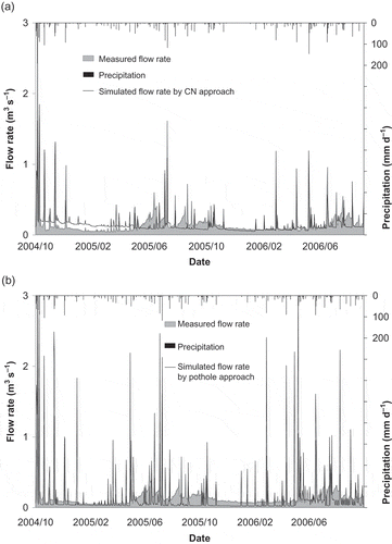
Table 3 The 10 most sensitive parameters and the final calibrated values of the parameters in the cases of the curve number (CN) approach and the pothole approach
In the CN approach, the values of NSE, coefficient of determination (R2), and root mean square error (RMSE) for the daily stream flow rate were 0.58, 0.66 and 4.88 (mm d−1), respectively, in the calibration period (October 2005 to September 2006), and 0.65, 0.65 and 7.14 (mm d−1), respectively, in the validation period (October 2004 to September 2005). The PBIAS values for the daily stream flow rate in the calibration and validation periods were 16 and 0%, respectively. In the calibration period, the ratio of the total amount of simulated stream outflow to the amount of rainfall was 41%, a value which was not so far from that of the observed stream outflow to the amount of rainfall (54%). Furthermore, in the validation period, the former value (63%) was very close to the latter value (64%). These ratios were calculated after subtracting the amount of canal water supply from the stream water flow because the canal water originates from outside the studied watershed.
In the pothole approach, the values of NSE, R2, and RMSE were ‒4.02, 0.57 and 10.50 (mm d−1), respectively, in the calibration period and -0.13, 0.55 and 12.17 (mm d−1) in the validation period. The PBIAS values in the calibration and validation periods were 7% and 10%, respectively. The ratio of the simulated stream outflow to the amount of rainfall was 49% in the calibration period and 55% in the validation period. The negative NSE values indicate that the pothole approach could not correctly simulate the significant hydrological processes that occurred in the studied watershed.
4.2. Water balance simulated by the CN approach
The water balance of a paddy field HRU simulated by the CN approach is shown in . The percolation from the undermost soil layer in the model to the underlying vadose zone varied from 0 to 15 mm d−1. The sum of the percolation and subsurface lateral flow was 969 mm y−1 during the rice-cropping season (from May 27 to October 10 in the 2-year study period; 137 days in a cropping season). On the other hand, the indirectly observed percolation at a paddy field near the outlet of the Arata River was 1480 mm during the 137-d rice-cropping season. The percolation was calculated from observed irrigation water volume, observed runoff water volume, AMeDAS database of the Hamamatsu observatory, ET estimated using the Penman-Monteith method and the crop coefficient described by the FAO (Citation1998b), and then adjusted for duration differences of cropping season which was 128 d in the observed paddy field. Therefore, the estimated value was 65% of that. This underestimation of the percolation is due to the two major limitations of the CN approach. One limitation is that this approach does not simulate the ponding water conditions and the resulting large percolation. In the CN approach, a part of a daily rainfall that does not discharge from the soil surface as surface runoff infiltrates into the soil profile and generates percolation. Therefore, in this approach, percolation occurs only on a rainy day. The percentage of rainy days was 38% in the rice-cropping seasons in the study period. However, the actual paddy fields in the study watershed were ponded even on fine days, and percolation should have occurred continuously. Another limitation is that the irrigation process in SWAT cannot yield any percolation although this process can generate water infiltration into the soil profile. This is because the irrigation process in SWAT stops when the soil water content reaches the field capacity, as described in Chapter 21.1 (Irrigation) in the theoretical documentation. The volume of water available for percolation within the soil layers in the model is calculated as follows, according to Chapter 8.2 (Percolation) in the theoretical documentation:
where SWly,excess is the volume of water available for percolation in a soil layer in the model on a given day (mm), SWly is the water content of the soil layer on a given day (mm) and FCly is the water content of the soil layer at the field capacity (mm). These two limitations in the CN approach are responsible for the difference between actual and simulated percolations. The auto-calibration process in SWAT cannot adjust this difference at the HRU level, because it is not caused by the parameter values but by the structure of the physically based model.
4.3. Water balance simulated by the pothole approach
The water balance of the paddy field HRU simulated by the pothole approach is shown in . The seepage (defined as infiltration from ponded water into the soil surface in SWAT) from the pothole to the soil layers in the model intermittently varied from 0 to 30 mm d−1. The simulated water balance () shows that the seepage was zero on most days even though surface runoff occurred. The occurrence of surface runoff indicates that the pothole is ponded with water. Seepage occurred occasionally, on June 28 and July 4, 2006. This result should differ from the actual infiltration in the paddy fields, which should have been almost constant under the ponded conditions. The reason for the disagreement between actual and simulated infiltrations can be found in the formulation of the pothole module algorithm. The seepage (infiltration) process stops (Vseep = 0) when the soil water content reaches the field capacity (SW ≥ FC) as described in Section 3.1 (Eq. 5). In addition, the soil layers in the model cannot become drier than the field capacity water content by the percolation process within soil layers in the model, because the volume of water available for percolation in a soil layer in the model is calculated by Eq. 11 and 12. Therefore, the seepage from the pothole to the soil layers becomes zero on most days. Using the pothole module for paddy fields is problematic because the recharge of aquifers by the percolation of ponded water is a feature of the paddy hydrology (Iwasaki et al. Citation2013). This problem does not occur for pothole landscapes. The difference between HRUs for paddy fields and pothole landscapes is the fraction of the HRU area that drains into the pothole (POT_FR). The fraction is set at 100% for paddy fields in this study to cover the entire HRU area by ponded water. On the other hand, it is less than 100% for pothole landscapes, and the soil layer in the model can become drier than the field capacity water content by the evaporation from the soil surface outside of the pothole. Therefore, the seepage process does not stop in the HRU for pothole landscapes.
Figure 8 Water balance in paddy field hydrological response units (HRU) simulated by the curve number (CN) approach (percolation from the undermost soil layer, surface runoff, evapotranspiration and ground water flow).
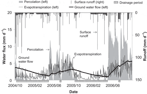
Figure 9 Water balance in paddy field hydrological response units (HRU) simulated by the pothole approach (seepage from the pothole, surface runoff, evapotranspiration and ground water flow).
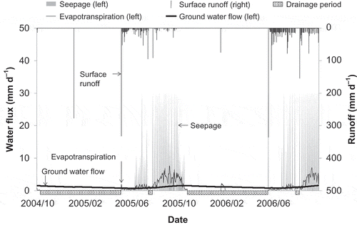
Table 4 Evapotranspiration (ET), surface runoff and seepage simulated by the pothole approach
None of the percolation from the undermost soil layer in the model to the underlying vadose zone, surface runoff and ET occurred in the simulation () during the drainage period except for on January 1 of each year, even though there were rainfalls () during the drainage period. These unrealistic simulation results are due to the formulation of the pothole HRU algorithm. First, the pothole can store ponded water even under the released condition during the drainage period, although the theoretical documentation explains that all water in the pothole flows out by the release operation. Second, none of surface runoff, percolation and evaporation occurs when ponded water is stored in the pothole.
The simulated ET values were unrealistically small (0.1 to 0.4 mm d−1) on several days such as May 7, 9 and 10, 2006 (), even though surface runoff from the pothole occurred on those days and the pothole was filled with water in the simulation. The reason for the small ET value can be found in the formulation of the pothole module HRU algorithm. The upper limit of evaporation from the pothole is defined as the amount of stored water in the pothole; therefore, ET becomes very small on the day when the ponded water is very low in the pothole. In addition, the evaporation process from the soil surface is not active when the pothole stores ponded water.
Unrealistically large surface runoff occurred in the simulation on the first day of the ponding period every year (); namely, 332 mm d−1 on April 29, 2005, and 336 mm d−1 on April 29, 2006. These runoff estimates are clearly inaccurate because the precipitations on those days were zero and the amounts of irrigation were only 12.3 mm d−1 on April 29, 2005, and 11.7 mm d−1 on April 29, 2006. This appears to be due to bugs in the pothole algorithm. We found that this problem can be eliminated by inserting the release operation on January 1 every year, even though the pothole was already released on October 4.
4.4. Comparison with previous studies
The NSE values for the stream flow rate in the previous studies that were conducted using the CN approach and the impounding approaches including the pothole approach are shown in .
Table 5 The Nash-Sutcliffe model efficiency (NSE) values in previous studies conducted using the curve number (CN) approach and the impounding approach
Kang et al. (Citation2006) and Xie and Cui (Citation2011) applied the impounding approaches. Kang et al. (Citation2006) developed an algorithm that generates a constant percolation rate in the paddy field HRU; therefore, unrealistically small percolation as observed in our simulation would have not occurred in their simulation. On the other hand, the approach of Xie and Cui (Citation2011) that used the pothole module may have experienced the unrealistically small percolation.
Tripathi et al. (Citation2005) and Somura et al. (Citation2009) obtained higher NSE values in their CN approaches than did the CN approach in this study. This may be due to the fact that the Arata River watershed is much smaller (3 km2) than their watersheds. In our study, the NSE value for the CN approach was higher than that for the pothole approach. However, the CN approach does not simulate the ponding process that commonly occurs in actual irrigated paddy fields. In the CN approach, daily surface runoff is calculated by Eq. 1 and 2 using the daily rainfall and the maximum retention storage S which is a function of the amount of rainfall in the preceding 5 d. Im et al. (Citation2007) showed that the correlation between the S value of their irrigated paddy fields and previous rainfall was low. They concluded that the irrigation to rice paddies was responsible for this low correlation, and mentioned that the criteria of antecedent moisture conditions in the CN approach should be rearranged to generate more accurate estimates of surface runoff from irrigated paddy fields.
Most of the previous studies were conducted using the CN approach. These studies resulted in higher NSE values at the watershed scales; however, the water balance of the paddy field HRU has not been examined. Since the NSE value can become higher if the model parameters in the HRUs other than paddy field HRUs were calibrated to compensate for the excess or deficiency of simulated water balance components in paddy field HRUs, a higher NSE value at the watershed scale does not guarantee that the paddy field HRUs were simulated reasonably.
4.5. Strategy for a better simulation
This study revealed the unsuitability of the pothole approach and a limitation on the percolation process in the CN approach. Im et al. (Citation2007) also revealed a limitation on surface runoff process in the CN approach. To cope with such unsuitability and limitations, the development of a paddy module is needed. Existing ideas for better hydrological simulations in paddy field HRUs are: employing ponding depth instead of 5-d antecedent rainfall depth as the antecedent moisture condition in the CN procedure (Im et al. Citation2007), subtracting the daily mean percolation from ponded water (Kang et al. Citation2006), and reproducing the effects of paddy irrigation and evapotranspiration on the cycle of increase and decrease of ponding depth (Xie and Cui Citation2011). Compared to the CN approach that does not simulate the ponded water conditions, the impounding approach seems much better if SWAT is used not only for hydrology but also for water quality, because the ponded water conditions should significantly affect the water quality of surface runoff water. More realistic hydrological simulation should lead to more realistic simulation of the biogeochemical processes such as nitrification, denitrification, mineralization, etc., in paddy fields. One promising idea is a further modification of the pothole module to be a more realistic impounding approach because this module already has impound/release operation, irrigation operation and cropping operation, all of which are readily applicable to rice paddy management.
5. CONCLUSIONS
This study confirms the unsuitability of the two approaches available in SWAT for simulating paddy field hydrology and indicates the need for the development of a paddy module in SWAT, although many researchers have applied SWAT to watersheds containing paddy fields and most of their studies resulted in high NSE values at the watershed scales.
The water balance in a paddy field HRU in the watershed containing irrigated paddy fields, which was simulated by the pothole approach, was significantly different from the actual paddy field hydrology; that is, percolation was zero on most days even under the ponded water conditions, no percolation, surface runoff or ET occurred during the drainage period, and ET was unrealistically small under the ponding period. This difference appears to be responsible for the low model efficiency for the stream flow rates at the outlet of the watershed. The cause of this difference is in the formulation of the pothole module algorithm that is inconsistent with the actual mechanism of paddy field hydrology.
The CN approach resulted in relatively higher NSE value for the stream flow rate at the outlet of the watershed; therefore, this approach appears to be better than the pothole approach for watershed-scale hydrology. However, the simulated percolation at a paddy field HRU resulted in a 35% underestimation of the measured value. This is due to a limitation of the CN approach; that is, this approach does not take into account the water ponding conditions that should generate much higher percolation.
Since SWAT is a physically based model, each primary process in the paddy field HRU must also be physically designed. Development of an impounding approach including the pothole module that can simulate the ponding conditions is needed for SWAT to be used for predicting the impact of land management practices in a watershed with various land uses including paddy fields.
References
- Arnold JG, Srinivasan R, Muttiah RS, Williams JR 1998: Large area hydrologic modeling and assessment part I: model development. J. Am. Water Resour. Assoc., 34, 73–89. doi:10.1111/j.1752-1688.1998.tb05961.x
- Behera S, Panda RK 2006: Evaluation of management alternatives for an agricultural watershed in a sub-humid subtropical region using a physical process based model. Agric. Ecosyst. Environ., 113, 62–72. doi:10.1016/j.agee.2005.08.032
- Du B, Arnold JG, Saleh A, Jaynes DB 2005: Development and application of SWAT to landscapes with tiles and potholes. Trans. ASAE, 48, 1121–1133. doi:10.13031/2013.18522
- Duan Q, Sorooshian S, Gupta V 1992: Effective and efficient global optimization for conceptual rainfall-runoff models. Water Resour. Res., 28, 1015–1031. doi:10.1029/91WR02985
- Eguchi S, Aoki K, Kohyama K 2011: Development of agricultural soil-profile physical properties database, Japan: SolphyJ. Proc. ASA-CSSA-SSSA International Annual Meetings (CD-ROM), 16–19 October 2011, San Antonio, TX.
- Food and Agriculture Organization (FAO) 1998a: Chapt. 8. ETc under soil water stress conditions. FAO irrigation and drainage paper No. 56: Crop evapotranspiration, 161–181. Rome, Italy: FAO.
- Food and Agriculture Organization (FAO) 1998b: Chapt. 6. ETc single crop coefficient. FAO irrigation and drainage paper No. 56: Crop evapotranspiration, 103–134. Rome, Italy: FAO.
- Gassman PW, Reyes MR, Green CH, Arnold JG 2007: The soil and water assessment tool: historical development, applications, and future research directions. Trans. ASABE, 50, 1211–1250. doi:10.13031/2013.23637
- Geospatial Information Authority of Japan (GSI) 2002: Topographic Map of 1:25,000. Geospatial Information Authority of Japan, Tsukuba, Japan.
- Geospatial Information Authority of Japan (GSI) 2010: Digital Japan Web System. Tsukuba, Japan: Geospatial Information Authority of Japan. http://www.gsi.go.jp/ENGLISH/page_e30233.html (May 2011).
- Gupta HV, Sorooshian S, Yapo PO 1999: Status of automatic calibration for hydrologic models: comparison with multilevel expert calibration. J. Hydrol. Eng., 4, 135–143. doi:10.1061/(ASCE)1084-0699(1999)4:2(135)
- Hjelmfelt AT 1980: Empirical investigation of curve number technique. J. Hydrol. Div., 106, 1471–1476.
- Hjelmfelt AT 1991: Investigation of curve number procedure. J. Hydraul. Eng., 117, 725–737. doi:10.1061/(ASCE)0733-9429(1991)117:6(725)
- Horie T, Nakagawa H, Centeno HGS, Kropff MJ 1995: The rice crop simulation model SIMRIW and its testing. In Eds. Matthews RB, Kropf MJ, Bachelet D, Modeling the Impact of Climate Change on Rice Production in Asia, pp. 51–66. CAB International and IRRI, Oxon.
- Im SJ, Park SW, Jang TI 2007: Application of SCS curve number method for irrigated paddy field. KSCE J. Civ. Eng., 11, 51–56. doi:10.1007/BF02823372
- Immerzeel WW, Gaur A, Zwart SJ 2008: Integrating remote sensing and a process-based hydrological model to evaluate water use and productivity in a south Indian catchment. Agric. Water Manage., 95, 11–24. doi:10.1016/j.agwat.2007.08.006
- Iwasaki Y, Ozaki M, Nakamura K, Horino H, Kawashima S 2013: Relationship between increment of groundwater level at the beginning of irrigation period and paddy filed area in the Tedori River Alluvial Fan Area, Japan. Paddy Water Environ., 11, 551–558. doi:10.1007/s10333-012-0348-9
- Japan Agriculture (JA) 2010: Rice farming calendar of Aichinokaori SBL (translation from Japanese). Japan Agriculture Toyohashi branch, Toyohashi, Japan (in Japanese).
- Japan Meteorological Agency 2011: AMeDAS (Automated Meteorological Data Acquisition System). Tokyo, Japan: Japan Meteorological Agency. http://www.jma.go.jp/en/amedas/index.html. (May 2011).
- Japan Water Agency (JWA) 1968: The technical history of Toyokawa canal (translation from Japanese), p.39. Japan Water Agency, Saitama, Japan. (in Japanese).
- Jung JW, Yoon KS, Choi DH, Lim SS, Choi WJ, Choi SM, Lim BJ 2012: Water management practices and SCS curve numbers of paddy fields equipped with surface drainage pipes. Agric. Water Manage., 110, 78–83. doi:10.1016/j.agwat.2012.03.014
- Kadoya M 1980: Analysis method of runoff (6): 3. Runoff of rainfall, Analysis of flood runoff by surface runoff model (translation from Japanese). J. Jpn. Soc. Irrig. Drain. Reclam. Eng., 48, 37–43 (in Japanese).
- Kang MS, Park SW, Lee JJ, Yoo KH 2006: Applying SWAT for TMDL programs to a small watershed containing rice paddy fields. Agric. Water Manage., 79, 72–92. doi:10.1016/j.agwat.2005.02.015
- Kurihara H, Aihara Y, Tsuno Y 1998: Crop. Rural culture association Japan, Tokyo (in Japanese).
- Minasny B, McBratney AB 2001: A comparison of the Australian and USDA/FAO soil particle-size classification systems. Aust. J. Soil Res., 39, 1443–1451. doi:10.1071/SR00065
- Monteith JL 1965: Evaporation and environment. In Ed. Fogg GF, The State and Movement of Water in Living Organisms, pp. 205–234. Cambridge University Press, Cambridge.
- Nash JE, Sutcliffe JV 1970: River flow forecasting through conceptual models part I - A discussion of principles. J. Hydrol., 10, 282–290. doi:10.1016/0022-1694(70)90255-6
- National Resources Conservation Service (NRCS) 2004: National Engineering Handbook, Part 630 Hydrology. USDA, Washington, DC.
- Neitsch SL, Arnold JG, Kiniry JR, Srinivasan R, Williams JR 2009: Soil and Water Assessment Tool Input Output file Documentation Version 2000. TR-365. College Station, TX: Texas Water Resources Institute.
- Neitsch SL, Arnold JG, Kiniry JR, Williams JR, King KW 2002: Soil and Water Assessment Tool Theoretical Documentation Version 2000. TR-191. College Station, TX: Texas Water Resources Institute.
- Ouyang W, Hao FH, Wang X, Cheng, H 2008: Nonpoint source pollution responses simulation for conversion cropland to forest in mountains by SWAT in China. Environ. Manage., 41, 79–89. doi:10.1007/s00267-007-9028-8
- Public Works Research Institute (PWRI) 2008: KuniJiban. Tsukuba, Japan: Public Works Research Institute. http://www.kunijiban.pwri.go.jp/en/index.html. (May 2011).
- Sakaguchi A, Eguchi S, Kato T, Kasuya M, Ono K, Miyata A, Tase N 2014: Development and evaluation of a paddy module for improving hydrological simulation in SWAT. Agric. Water Manage., 137, 116–122. doi:10.1016/j.agwat.2014.01.009
- Soil Conservation Service (SCS) 1972: National Engineering Handbook, Section 4, Hydrology. USDA, Washington, DC.
- Somura H, Arnold J, Hoffman D, Takeda I, Mori Y, Di Luzio M 2009: Impact of climate change on the Hii River basin and salinity in Lake Shinji: a case study using the SWAT model and a regression curve. Hydrol. Process., 23, 1887–1900. doi:10.1002/hyp.7321
- Takata Y, Nakai M, Obara H 2009: Digital soil map of Japanese croplands in 1992. Jpn. J. Soil Sci. Plant Nutr., 80, 502–505 (in Japanese with English abstract).
- Tripathi MP, Panda RK, Raghuwanshi NS 2005: Development of effective management plan for critical subwatersheds using SWAT model. Hydrol. Processes., 19, 809–826. doi:10.1002/hyp.5618
- van Genuchten MTh 1980: A closed-form equation for predicting the hydraulic conductivity of unsaturated soils. Soil Sci. Soc. Am. J., 44, 892–898. doi:10.2136/sssaj1980.03615995004400050002x
- van Griensven A, Meixner T, Grunwald S, Bishop T, Diluzio M, Srinivasan R 2006: A global sensitivity analysis tool for the parameters of multi-variable catchment models. J. Hydrol., 324, 10–23. doi:10.1016/j.jhydrol.2005.09.008
- Watanabe H, Boulange J, Eguchi S, Kato T, Sakaguchi A, Gassman PW 2013: Rice paddy module development in SWAT (Discussion session). Handout received in 3rd SWAT-SEEA conference, 18–19 Jun. 2013, Bogor, Indonesia.
- Xie X, Cui Y 2011: Development and test of SWAT for modeling hydrological processes in irrigation districts with paddy rice. J. Hydrol., 396, 61–71. doi:10.1016/j.jhydrol.2010.10.032
- Yamada R, Shirai K, Ogino K, Imagawa M 2003: Balance of nitrogen income and expenditure in field cultivation areas at red-yellow soil by using of the capillary lysimeter method. Res. Bull. Aichi Agric. Res. Ctr., 35, 85–90 (in Japanese with English abstract).