
Abstract
In this paper, I firstly describe wind erosion, the primary cause of the desertification in the Sahel region, from three different perspectives – namely, on microscopic (a few centimeters), mesoscopic (a few tens of meters to a few hundred meters) and macroscopic (a few kilometers to a few tens of kilometers) scales to offer a multilateral description of the realities of desertification. The desertification in the Sahel region can be understood on a microscopic scale as a deterioration of soil properties, caused by the loose sand layer being blown away by the wind, and by the associated exposure of the crust (layer); on a mesoscopic scale as a phenomenon that involves the topsoil and its component nutrients being spatially localized to an area not available for crop production; and on a macroscopic scale as a phenomenon in which the land becomes patchy with decreasing vegetation and eventually turns into bare land. Then, I introduce a new countermeasure against desertification, called the fallow band system. It is a technique on a microscopic scale that can be used to cover the crust (layer) by placing a loose sand layer on top of it without investing in capital or labor, and on a mesoscopic scale that can be used to connect the spatially localized topsoil and its nutrients with crop production. Finally, I mention future research needs.
1. PREFACE – THE LEAST DEVELOPED COUNTRIES IN THE SOUTHERN SAHARA DESERT SUFFER FROM DESERTIFICATION
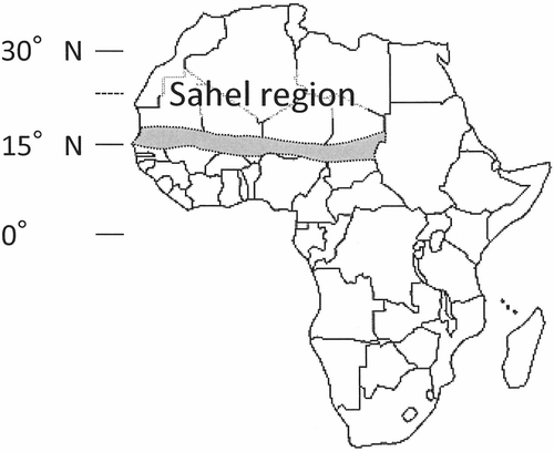
The Sahel region, in a narrow sense, refers to an area along the southern ridges of the Sahara Desert with an average annual rainfall of between 200 and 600 mm (the area extends roughly 400 km north to south and roughly 4000 km east to west) and includes parts of the following six countries, which are regarded as the least developed countries of the world, namely, Senegal, Mauritania, Mali, Burkina Faso, Niger and Chad (). In this region, the small amount of rainfall combined with the less fertile and extremely sandy soil (described in detail below) is causing chronic food shortages, and a serious famine can be triggered when the region is hit by drought. According to the United Nations Environment Programme (UNEP Citation2002), at least 100,000 people died during the drought of 1972 to 1984, and in 1974 at least 750,000 people in Mali, Niger and Mauritania had to rely entirely on food aid for survival. At that time, the population of the six Sahel countries was roughly 30 million, according to World Population Prospects published by the United Nations Department of Economic and Social Affairs (UNDESA; DESA Citation2010). In addition, according to UNEP (Citation1997), the Sahel region is considered to have one of the highest risks of desertification in the world, and this is further worsening the food shortage. In this paper, the term “desertification” is defined as land degradation in arid, semi-arid and dry sub-humid areas, resulting from various factors, including climate variations and human activity in line with the definition adopted by the United Nations Convention to Combat Desertification in Those Countries Experiencing Serious Drought and/or Desertification, Particularly in Africa (UNCCD). The term “land degradation” used in this context refers to reduction or loss, in arid, semi-arid and dry sub-humid areas, of the biological or economic productivity and complexity of rainfed cropland, irrigated cropland or range, pasture, forest and woodlands.
Figure 1 The location of the Sahel region.
A wide range of research has already been conducted on the problem of desertification in the Sahel, where almost no fertilizers are used because farmers do not have the extra cash that fertilization requires. According to the Food and Agriculture Organization of the United Nations (FAO Citation2011), the average fertilizer use in the six Sahel countries is about 6 kg ha−1, which is less than 1/10 that used in Southeast Asian and Latin American countries. Because of this, cultivation causes decrease in soil nutrients. Detailed studies on this chemical degradation of the soil (depletion of soil nutrients) and its recovery through fertilization have been conducted by A. Bationo, A. Buerkert, K. Hayashi and others (see Bationo and Mokwunye Citation1991; Bationo et al. Citation1993; Buerkert et al. Citation2000; Hayashi et al. Citation2008; etc.). Additionally, Nakamura et al. (Citation2010) have published work on the depletion of soil organic matter as a result of cultivation and its recovery through the application of organic amendment. However, nothing in the literature deals systematically with the effects of wind erosion, the primary cause of desertification in the Sahel region (Lal Citation1993), on soil fertility. Therefore, this topic is the focus of the current paper.
This paper begins by providing an overview of the agro-ecosystem and desertification in the Sahel region. It then describes wind erosion, the primary cause of the desertification in the Sahel, from three different perspectives, namely, on microscopic (a few centimeters), mesoscopic (a few tens of meters to a few hundred meters) and macroscopic (a few kilometers to a few tens of kilometers) scales, to offer a multilateral description of the realities of the desertification. Lastly, a new countermeasure called the “fallow band system” is introduced.
2. THE AGRO-ECOSYSTEM OF THE SAHEL REGION – THICK SAND COVERS CHRONIC DROUGHT AREAS
2.1. Climate and vegetation
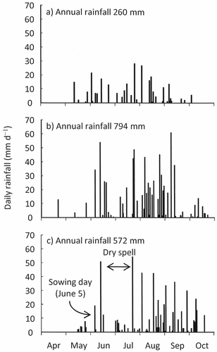
The rainfall in the Sahel region is associated with two air masses. One is the equatorial maritime air mass represented by humid southwesterly monsoons and the other is the tropical continental air mass represented by the dry northeast trade wind (Harmattan). The area where the two air masses meet is called an intertropical convergence zone (ITCZ), and rainfall is observed only on the southern side of this ITCZ (Kitamura Citation1997). Although the ITCZ moves north or south depending on the overruling air mass, the rainfall in the Sahel region is concentrated between July and September when the ITCZ is at its furthest north (Shinoda Citation1992), and almost no rainfall is observed between November and March when the ITCZ is in its southern position. Other characteristics of the rainfall are the magnitude of its annual fluctuations and the occurrence of dry spells (a period during which almost no rainfall is observed despite it being the rainy season). For example, at the International Crops Research Institute for the Semi-Arid Tropics (ICRISAT) West and Central Africa (Republic of Niger), the average annual rainfall between 1983 and 2009 was 530 ± 120 mm (standard deviation). However, the rainfall in the year with the least precipitation (1984) was a meager 260 mm (), while the rainfall in the year with the most precipitation (1994) was 794 mm (). As for the dry spell, in 2002 () for example, only 32 mm of rainfall was observed in the 35 days between day 12 and day 46 after sowing.
Figure 2 Daily rainfall for the year with (a) the least rain, (b) the most rain and (c) a severe dry spell at the International Crops Research Institute for the Semi-Arid Tropics (ICRISAT) West and Central Africa (Niger).
The climatic divisions of the Sahel region according to the UNCCD are arid (0.05 ≤ precipitation/maximum evapotranspiration < 0.20) in the northern part and semi-arid (0.20 ≤ precipitation/maximum evapotranspiration < 0.50) in the southern part. The region is also identified according to the FAO agro-ecological zones as warm arid and semi-arid tropical zones and according to the Köppen climate classification system, it is BWh (desert climate with an average annual temperature of 18°C or higher) in its northern part and BSh (steppe climate with an average annual temperature of 18°C or higher) in its southern part. In addition, according to the United States Department of Agriculture (USDA) Soil Taxonomy (Soil Survey Staff Citation2010), the soil temperature regime of the region is primarily isomegathermic and the soil moisture regime is ustic.
The vegetation in the Sahel region has been explained in detail by Imagawa (Citation1992) and the Japan International Research Center for Agricultural Sciences (JIRCAS Citation2009). The latter also goes on to explain how it is used locally. The main vegetation landscape of the Sahel region is a steppe of thorny bushes and is characterized by Acacia albida Del. (Faidherbia albida (Del.) Chev.) whose leaves grow in the dry season, and the gum arabic producing Acacia senegal (L.) Willd. (Senegalia senegal (L.) Britton) and other bushes of the Acacia genus (the former used to belong to the Acacia genus), as well as by the short-stem grasses of the Poaceae family, which includes the genera Andropogon, Aristida, Cenchrus and Eragrostis. Adansonia digitata L. (baobab) can also be seen in some areas. Moreover, in my survey area, Mitracarpus scaber Zucc. (a plant of the Rubiaceae family) is seen as an index of tired land, and Sida cordifolia L. (a plant of the Malvaceae family) is seen as an index of the high grazing pressure among local farmers.
2.2. Geological and geomorphological features and soil
The geological and geomorphological features of the Sahel region are explained in detail in Imagawa (Citation1992), Wakatsuki (Citation1997a) and Graef (Citation2011). According to them, the Sahel region extends east and west of the depression zone (shield) lying between the mountains and plateaus of the Sahara Desert and the plateaus along the coastline of the Gulf of Guinea. This depression zone is roughly divided into two areas by the Aïr Mountains and the Jos Plateau, which extend to the north and south of the central part of Niger and Nigeria.
The framework of the shield consists of ancient Precambrian age rock (bedrock: the oldest part was formed more than 2 billion years ago), and distributed inside is sedimentary rock dating from the Paleozoic Era to the Tertiary Period. Furthermore, widely distributed on the dissected these rocks is a sand layer (sand cover: generally, an extremely sandy layer that contains more than 80 to 90% sand and with a thickness of a few meters to a few dozen meters) dating from the Quaternary period. According to Nagumo (Citation1995), most agricultural land is created on top of this sand cover. The bulk of the sand cover consists of aeolian deposits carried by the wind from the present Sahara Desert around the last glacial maximum (approximately 20,000 years ago). According to Kadomura (Citation1992), during the period between 20,000 and 12,000 years ago, a desert with lines of sand dunes extended over the area where the present annual rainfall is 800 mm. Reflecting the widely distributed sand cover, nearly all of the Sahel region is classified as Arenosols in the World Soil Resources Map (FAO/EC/ISRIC Citation2003) based on the World Reference Base for Soil Resources (WRB) (1998). On the other hand, USDA Soil Taxonomy (Soil Survey Staff Citation2010) classifies the area mainly as Psamments. As stated by Wakatsuki (Citation1997b), the Entisols in this case only mean that the morphological development of the soil is premature but the soil itself is actually strongly weathered, containing almost no easily weatherable primary minerals. When evidence of clay illuviation is found, it may be classified as Alfisols (for example, Psammentic Paleustalfs). However, it cannot be easily clarified because the evidence for clay illuviation, if any, is extremely weak (West et al. Citation1984), and it is also possible that wind-blown sand in which clay and silt have been removed is covering sandy soil formed from preexisting sedimentary rocks. In any case, a characteristic feature of the soil of the Sahel region is its thick sand.
2.3. Agriculture
Livestock farming based on nomadic grazing is practiced in the northern part where there is limited rainfall. Livestock farming and drought-resistant crops such as pearl millet (Pennisetum glaucum (L.) R. Br.), sorghum (Sorghum bicolor (L.) Moench), cowpeas (Vigna unguiculata (L.) Walp) and peanuts (Arachis hypogaea L.) are grown without irrigation (cowpeas are often mix cropped with pearl millet) in the southern part where the rainfall exceeds the cultivation limit (annual precipitation of about 300 mm). However, it is difficult to maintain a stable yield since it is near the cultivation limit, the fluctuations in annual rainfall are large and there are also dry spells (). Rice farming is also seen along the permanent rivers such as the Niger River. Another characteristic of agriculture in the Sahel region is the mix of crop farming and livestock farming. A symbiotic system is established here. After pearl millet or sorghum has been harvested by the crop farmers, the livestock farmers graze their livestock (cows, sheep and goats) in the field and manure is returned to the field. However, this symbiotic system has started to change with the recent increase in the settlement of livestock farmers and their entry into crop farming (Shinjo et al. Citation2008).
The main method used to maintain soil fertility is to incorporate household waste into fields near (closer than about 1 km) the village or settlement. Night corralling (a system whereby livestock are accommodated in a field overnight thus supplying the field with manure and urine) is largely used in fields located roughly 1–2 km away. Fields farther than 2 km away are mostly left fallow (Hayashi Citation2005; Hayashi et al. Citation2006). The percentages of fields managed using these methods are as follows: household waste 16%, animal manure and urine 18% and fallow 66% (Hayashi et al. Citation2006). However, a reduction in the number of fallow fields and fallow years has been reported in recent years (Wezel and Haigis Citation2002).
3. THE OUTLINE OF THE DESERTIFICATION IN THE SAHEL REGION – THE WIND IS THE CULPRIT CAUSING THE DESERTIFICATION
As described above, wind erosion is thought to be the main cause of desertification in the Sahel region (Lal Citation1993). To explain wind erosion in simple terms, it is a phenomenon where the topsoil of a field is removed by a strong wind (). Since the topsoil normally has a higher nutrient content than the subsoil, wind erosion reduces the soil nutrients (Daniel and Langham Citation1936; Zobeck and Fryrear Citation1986; Sterk et al. Citation1996; Larney et al. Citation1998; Bielders et al. Citation2002) and also reduces soil productivity (Lyles Citation1975; Larney et al. Citation1998: ). In addition, when the topsoil is lost, subsoil with poor physical properties may be exposed, resulting in the decrease in the soil permeability. Moreover, wind erosion may affect crop growth through physical damage (abrasion) and by burying crops under blown sand (Michels et al. Citation1993, Citation1995a).
Figure 3 Sandstorm causing wind erosion.
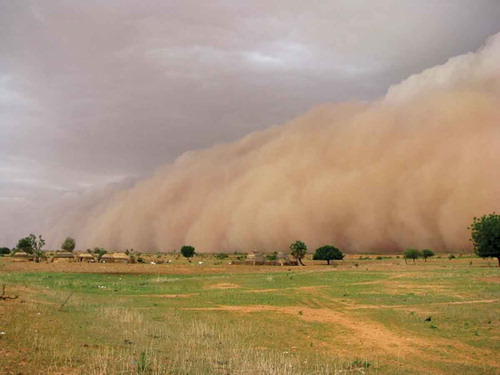
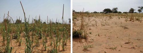
Figure 4 Pearl millet (Pennisetum glaucum (L.) R. Br.) fields unaffected by desertification (left) and heavily affected by desertification (right).
4. DESERTIFICATION AS SEEN ON A MESOSCOPIC SCALE – WHERE DOES THE WIND-BLOWN SOIL GO?
I will focus on wind erosion, the main cause of the desertification, on a mesoscopic scale (on a scale of a few tens of meters to a few hundred meters). As introduced above, wind erosion research in the Sahel region has already been conducted by K. Michels, G. Sterk, C.L. Bielders and others. However, because the conventionally used sampler was imperfect (Zobeck et al. Citation2003), the amount of topsoil lost from the field by wind erosion and the soil nutrients have yet to be accurately assessed. For this purpose, my colleagues and I developed a new device called an Aeolian Materials Sampler (AMS) that makes up for the imperfection of the conventional sampler, and demonstrated its validity in wind tunnel and field experiments (Ikazaki et al. Citation2009b, Citation2010, Citation2011a). In addition, the 3 years of field experiments using the AMS and Big Spring Number Eight sampler (BSNE) conducted at the ICRISAT West and Central Africa (: Ikazaki et al. Citation2011b, Citation2012) uncovered the following points: (1) between 60 and 80 Mg ha−1 y−1 (4 to 5 mm y−1) of topsoil was lost from the field by wind erosion in the Sahel region (according to Renard et al. (Citation1997)—a topsoil loss of more than 2.5 to 12.4 Mg ha−1 y−1 has an economic impact on crop production in farmland of the United States); (2) this amount was equivalent to 40 to 50 kg ha−1 y−1 of soil nitrogen (i.e., two to three times greater than the amount absorbed by pearl millet); (3) however, when there was a herbaceous fallow more than 5 m wide downwind (west side) of the field, most (roughly 75 to 95%) of the blown soil and nutrients were captured by this fallow (but since clay and silt was suspended during the transportation, little of it was captured by the herbaceous fallow). In short, when the desertification in the Sahel region is viewed through the eyes of a bird (on a mesoscopic scale), it remains, as already understood, a phenomenon that involves the topsoil and its component nutrients being blown away from the field. However, when seen on a larger scale, the topsoil and nutrients are not lost but spatially localized. This localization is a problem because the soil and nutrients are accumulated in places that cannot be used for cultivation—for example, in borders between fields, on common land and in dried-up riverbeds—and so are not currently utilized for production.
Figure 5 A scene from a field experiment on wind erosion.
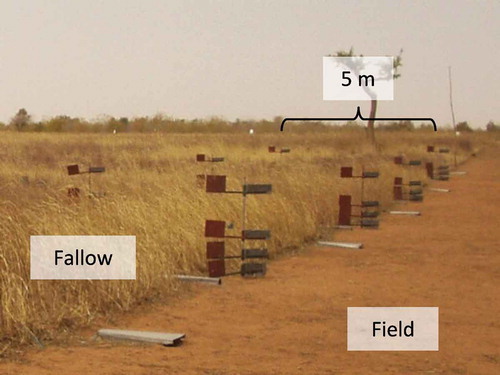
Figure 6 Schematic diagram of the topsoil.
5. DESERTIFICATION AS SEEN ON A MICROSCOPIC SCALE – SANDY SOIL DOES NOT NECESSARILY MEAN GOOD WATER PERMEABILITY
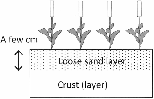
Next, wind erosion is observed on a microscopic scale (a few centimeters), mainly from the viewpoint of the changes in soil physical properties of the topsoil. As described by Rajot et al. (Citation2003), the structure of the topsoil in the Sahel region consists of a crust (or a crust layer) that has relatively poor water permeability and a loose sand layer (a few centimeters thick) with high water permeability lying on top of the crust (). Although both layers are extremely sandy, the crust (or the crust layer) contains more than 5% clay and silt combined (usually less than 10%) whereas the loose sand layer contains less than 5% (Ambouta et al. Citation1996). The crust is normally a structural crust (Graef and Stahr Citation2000) and the crust layer is thought to be either a structural crust or a depositional crust in layers (). Many questions remain regarding the formation processes of the crust layers, and perhaps not all were formed in the present environment. Some layers may have been formed around 20,000 years ago when the sand cover reached the present location. A series of studies conducted by C. Valentin, U. Tanaka and others (e.g., Valentin and Bresson Citation1992; Tanaka Citation2001) explains in detail the morphology and formation processes of the crust in the Sahel. The loose sand layer is formed when the hooves of livestock (Rajot et al. Citation2003) and push hoe weeding (the disturbance of a few centimeters of topsoil) destroy the structure, and the clay and silt fraction is carried away by the wind or is washed away downwards by water.
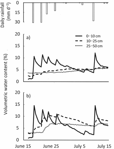
When wind erosion occurs in this type of topsoil, the loose sand layer is blown away (but never lost, just spatially localized, as explained in section 4) at an extremely fast speed of 4 to 5 mm y−1, and eventually the crust (layer) is exposed. shows the changes in the soil moisture content in the early rainy season in the area where the crust is exposed and where a loose sand layer of 3 cm is present on top of the crust (Ikazaki et al. unpublished). As shown in , when the crust (layer) is exposed, the water permeability of the topsoil is decreased and the soil moisture content is significantly decreased. Furthermore, once the crust (layer) is exposed, a maximum 84% of the pearl mullet pockets fail to produce a crop (Ikazaki et al. unpublished). In short, when desertification in the Sahel region is viewed through the eyes of an insect (on a microscopic scale), it can be understood as a deterioration of the physical properties of the soil, caused by the loose sand layer being blown away by the wind, and by the associated exposure of the crust (layer).
Figure 7 A cross-sectional photograph of a depositional crust (the arrows are pointing at the crust). Photo courtesy of Dr. Ueru Tanaka.
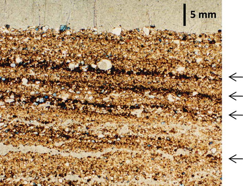
Figure 8 Soil moisture content in the early rainy season (a) in an area where the crust is exposed and (b) in an area with a loose sand layer on top of the crust.
6. DESERTIFICATION AS SEEN ON A MACROSCOPIC SCALE – LAND APPEARS TO BE IN PATCHES WHEN OBSERVED FROM OUTER SPACE WITH PROGRESSION OF THE DESERTIFICATION
Next, the desertification in the Sahel region is examined using satellite images. When we define desertification as a decrease in vegetation, it may be possible to define desertification seen through satellite images as a reduction in the Normalized Difference Vegetation Index (NDVI). In fact, many previous studies have used the NDVI or adjusted NDVI value as an index of desertification (for example, Mouat et al. Citation1997). However, as pointed out by Tucker et al. (Citation1991a), the NDVI is greatly influenced by yearly precipitation. For this reason, there is a problem, namely that even when the NDVI decreases, we cannot say for sure whether it is the result of desertification or the result of poor rainfall in that particular year.
Meanwhile, Schlesinger et al. (Citation1990, Citation1996) showed that along with the progression of desertification, the uneven distribution (the degree of spatial heterogeneity) of the soil moisture content and soil nutrients increases and, as a result, the spatial heterogeneity of the vegetation also increases. What this means is that desertification does not proceed uniformly, but progresses selectively from weak land (patchy progression). This offered the possibility of using the spatial heterogeneity of vegetation that tends to remain unaffected by precipitation as a new index of desertification instead of the amount of vegetation, which is easily affected by precipitation. In this case, it might be possible to describe desertification as an increase in the spatial heterogeneity of vegetation. Based on this thinking, Tucker et al. (Citation1991b) became the first to evaluate desertification using the coefficient of variation of the NDVI (an index of spatial heterogeneity: i.e., the value obtained when the standard deviation is divided by the average value) as an index, and the method was later improved by Milich & Weiss (Citation2000). However, the problem with these studies is that they also use the NDVI as an index of vegetation unconditionally. Tucker et al. (Citation1985a, Citation1985b) reported environmental conditions where the NDVI tends not to properly reflect the actual vegetation of an area. Therefore, when using the NDVI as an index of vegetation, it is crucial to first conduct a field survey of an area to confirm that the NDVI does in fact reflect the actual vegetation of the area. In addition, the above studies assume that desertification is simply an increase in the spatial heterogeneity of vegetation. However, when land becomes completely bare, the spatial heterogeneity of vegetation becomes zero. Therefore, when desertification progresses, the spatial heterogeneity of vegetation is most likely to decrease from a certain point in time ().
Figure 9 Relationship between the degree of desertification and the spatial heterogeneity of vegetation (hypothesis).
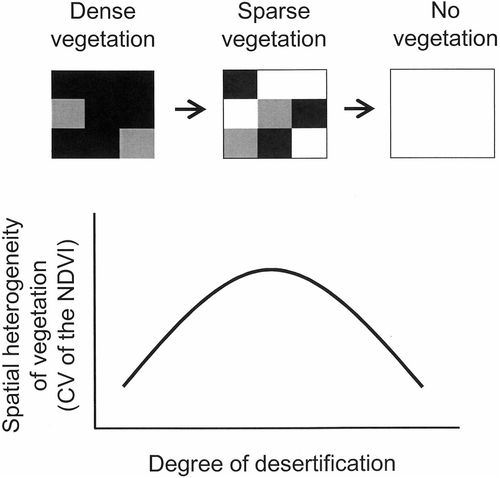
With the above considerations forming the background, my colleagues and I established the hypothesis that the spatial heterogeneity of vegetation will initially increase and then later decrease as desertification proceeds (), and explored the possibility of a new desertification assessment method using Landsat Thematic Mapper (TM) images (30 m resolution) obtained during six periods between 1986 and 2002 (Shinjo et al. Citation2005). The results showed that (1) the NDVI computed from the Landsat TM images reflected the biomass of the vegetation in the target area (ground truth) and (2) although the hypothesis could not be verified temporally because none of the areas that were dense in vegetation became bare between 1986 and 2002, it showed that the hypothesis can be verified spatially—that is, when regions ranging from areas with dense vegetation to areas of bare land were extracted in the particular year, the changes in the spatial heterogeneity of the vegetation were confirmed, as shown in . These results suggest that, when viewed through the eyes of a satellite (on a macroscopic scale), the desertification in the Sahel region can be understood as a phenomenon that begins with a decrease in vegetation (or land productivity) in areas that are comparatively sensitive to wind erosion; then the land as a whole becomes patchy, and eventually turns into bare land.
7. A COUNTERMEASURE AGAINST WIND EROSION, CALLED THE “FALLOW BAND SYSTEM” – USING WIND AS AN ALLY IN PREVENTING DESERTIFICATION AND RESOLVING FOOD SHORTAGES
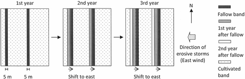
Lastly, I introduce a new wind erosion control technique called the fallow band system. Until now, techniques such as ridging (Bielders et al. Citation2000), mulching using the stover of the harvested crops (Michels et al. Citation1995b; Sterk and Spaan Citation1997; Buerkert and Lamers Citation1999; etc.), and the establishment of windbreak trees and windbreak barriers (Banzhaf et al. Citation1992; Michels et al. Citation1998; etc.) have been proposed as countermeasures against wind erosion in the Sahel region. However, in spite of the demonstrated effectiveness of these techniques, they have not been adopted by the local farmers (Rinaudo Citation1996). This is probably because no study has yet fully considered the feasibility of the use of these techniques by the farmers of the Sahel region who are tight in terms of both cash and labor (Matlon Citation1987; Nagy et al. Citation1988; Ruthven and David Citation1995). For example, approximately 60% of Niger’s population are in extreme poverty and live on less than US$1 a day, and many of its young people go to work in countries along the Gulf of Guinea. Taking this into consideration, my colleagues and I have developed a new low-input countermeasure called the fallow band system (Ikazaki et al. Citation2011c) that could be adopted by the farmers of the Sahel region, based on the results from the field experiment introduced in section 4 (desertification seen on a mesoscopic scale). An overview of the technique is as follows (): (1) multiple fallow bands, each 5 m wide, are created in cultivated land, at a right angle to the direction of the erosive sandstorms (easterly winds). The fallow band referred to here is a belt-like herbaceous fallow that can easily be created simply by not seeding or weeding the land (i.e., by doing nothing). The fallow bands are left untouched in the cultivated land even after the harvest, so as to capture aeolian materials (topsoil carried by the wind) with a large amount of nutrients between the dry season and the following early rainy season (wind erosion prevention effect). (2) During the next rainy season, the fallow bands are moved upwind (eastwards) and crop is planted on the previous year’s fallow band. This will allow the aeolian materials and the large amount of nutrients that they captured during the previous year to be utilized in crop production (fertility and yield improvement effect). (3) Step 2 is continually repeated.
Figure 10 Land use of a field employing the fallow band system.
The results obtained from the verification tests conducted by my colleagues and me to confirm the effectiveness of this system are as follows: (1) wind erosion can be prevented effectively (, Ikazaki et al. Citation2011c). (2) The aeolian materials captured by the fallow band can increase the quantity of soil nutrients that can be used by crops (e.g., nitrogen available for crops was increased by 60 kg ha−1 y−1), primarily through the decomposition of the trapped coarse organic matter. (3) They also can improve the soil permeability, thus increasing the soil water that can be used by crops (e.g., volumetric water content was increased by 30% in the early stages of plant growth). This was found to be the result of the reconstruction of the loose sand layer with the aeolian materials captured by the fallow band, on top of the exposed crust that had lost its highly permeable loose sand layer (). (4) As a result, when fallow bands are created at intervals of more than 29 m, the yield from the entire field can be increased by 36 to 81% compared to the field without the system (Ikazaki et al. Citation2009a: ). In short, the fallow band system, when viewed on a microscopic scale, is a technique that can be used to cover the crust (layer) by placing a loose sand layer on top of it without investing in capital or labor, and, on a mesoscopic scale, it is a technique that can be used to connect the topsoil and its nutrients, which will otherwise be spatially localized by the wind to where they are not available for crops, with crop production.
Figure 11 Trapping efficiency of a single fallow band for the wind-blown soil (combines data presented in Ikazaki et al. Citation2011c, –).
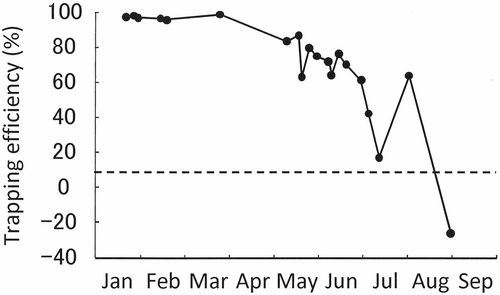
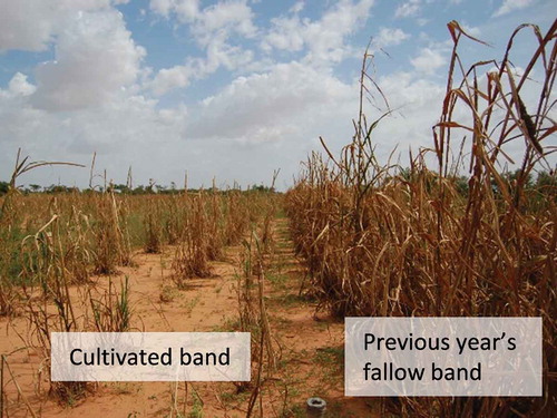
Figure 12 The ground surface at the boundary between the cultivated band and the previous year’s fallow band (the gray area in the cultivated band is where the crust has been exposed).
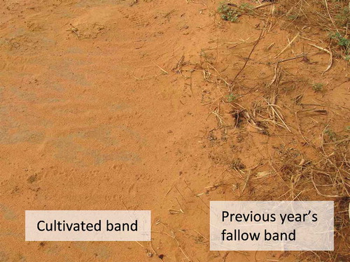
Figure 13 Differences between growth of pearl millet (Pennisetum glaucum (L.) R. Br.) planted in a cultivated band and in the previous year’s fallow band.
8. SUMMARY AND FUTURE RESEARCH NEEDS – BLOWIN’ IN THE WIND OF THE SAHEL
So far, I described the desertification, mainly caused by wind erosion, in the Sahel region from three different viewpoints (microscopic, mesoscopic and macroscopic) and introduced a new low-input countermeasure called the fallow band system. Now, I describe our future challenges. Firstly, the fallow band system is not a magic bullet. It is a technique that was developed as a result of the huge shock that my colleagues and I experienced when we realized that almost no farmer in the Sahel region was making use of the conventional wind erosion control techniques despite their effects. The fallow band system was designed with the highest priority given to the feasibility of its use by the Sahelian farmers and with the strong hope of making some progress in combating desertification. For this reason, while it is possible to improve the present condition with this technique, the complete prevention of desertification and the complete restoration of the soil fertility of an entire field are difficult to achieve solely using this technique. Thus, along with further improvement of the fallow band system, highly effective anti-desertification techniques should be developed through organic integration of this technique and others. In terms of the improvement of the fallow band system, Chamaecrista mimosoides (L.) E. Greene (hereafter CM), a plant of the legume family that fixes atmospheric nitrogen, as determined by Tobita et al. (Citation2011), may hold the key. CM tends not to be eaten by livestock and has a strong enough stem to resist physical damage from blown soil. Therefore, if CM is introduced into the fallow band, it can be expected to strengthen both the wind erosion prevention effect and the yield improvement effect of the fallow band system. As for the soil fertility improvement technique, which is to be integrated with the fallow band system, cowpeas that fix atmospheric nitrogen and that are often mix cropped with pearl millet may be the key. A highly effective mix cropping system has been proposed by Saidou et al. (Citation2011), lines with higher atmospheric nitrogen fixation ability and lines that meet the needs of the farmers of the Sahel region have been reported by Matsunaga et al. (Citation2008), and the drought and heat resistance of cowpeas has been studied by Omae et al. (Citation2007).
Next, I point out some issues for consideration in future research on the loose sand layer and the crust (layer). As described above, the loose sand layer and the crust (layer) are the ultimate determinants of the soil permeability of the topsoil in the Sahel region, but few studies have yet been conducted on them. For example, we have no information regarding the best thickness of the loose sand layer for crop production. As explained above, if the loose sand layer is less than a certain thickness, the physical properties of the topsoil deteriorate, but when it exceeds a certain thickness it may accelerate the leaching of nutrients (especially nitrogen) from the topsoil. This is because it is an extremely sandy soil, and so the soil has a naturally low nutrient holding capacity. Future research is required on appropriate methods for managing loose sand layers and crusts (layers).
As a final point, further research is needed to determine the most effective method for spreading a technique. This is important because it is clear from the work that my colleagues and I have undertaken (Sasaki et al. Citation2012) that the way technology is introduced greatly affects the degree to which it takes root among the local farmers of the Sahel. In other words, even when a highly effective technology is developed, it will not be adopted if the method used to disseminate it is wrong.
Acknowledgments
Part of this work was supported by the Toyota Foundation [D01-B3-004], Kyoto University Foundation [21 short-term dispatch], Japan Society for the Promotion of Science (JSPS) Grants-in-Aid for Scientific Research [06J03341, 20405005, 22405020, 22880018, 26870475].
REFERENCES
- Ambouta JMK , Valentin C , Laverdiere MR 1996: Jachère et croûte d’érosion au Sahel. Sécheresse , 7, 269–275 (in French with English summary).
- Banzhaf J , Leihner DE , Buerkert A , Serafini PG 1992: Soil tillage and windbreak effects on millet and cowpea: I. Wind speed, evaporation, and wind erosion. Agron. J., 84, 1056–1060. doi:10.2134/agronj1992.00021962008400060028x
- Bationo A , Mokwunye AU 1991: Alleviating soil fertility constraints to increased crop production in West Africa: the experience in the Sahel. Fert. Res., 29, 95−115.
- Bationo A , Christianson CB , Klaij MC 1993: The effect of crop residue and fertilizer use on pearl millet yields in Niger. Fert. Res., 34, 251−258. doi:10.1007/BF00750571
- Bielders CL , Michels K , Rajot JL 2000: On-farm evaluation of ridging and residue management practices to reduce wind erosion in Niger. Soil Sci. Soc. Am. J., 64, 1776–1785. doi:10.2136/sssaj2000.6451776x
- Bielders CL , Rajot JL , Amadou M 2002: Transport of soil and nutrients by wind in bush fallow land and traditionally managed cultivated fields in the Sahel. Geoderma , 109, 19–39. doi:10.1016/S0016-7061(02)00138-6
- Buerkert A , Lamers JPA 1999: Soil erosion and deposition effects on surface characteristics and pearl millet growth in the West African Sahel. Plant Soil , 215, 239–253. doi:10.1023/A:1004755731732
- Buerkert A , Bationo A , Dossa K 2000: Mechanisms of residue mulch-induced cereal growth increases in West Africa. Soil Sci. Soc. Am. J., 64, 346−358. doi:10.2136/sssaj2000.641346x
- Daniel HA , Langham WH 1936: The effect of wind erosion and cultivation on the total nitrogen and organic matter content of soils in the Southern High Plains. J. Am. Soc. Agron., 28, 587–596. doi:10.2134/agronj1936.00021962002800080001x
- Department of Economic and Social Affairs (DESA) 2010: World Population Prospects: the 2010 Revision. http://esa.un.org/unpd/wpp/unpp/panel_population.htm November, 2014.
- FAO 2011: FAOSTAT. http://faostat.fao.org/ (November, 2014).
- FAO/EC/ISRIC 2003: Map of world soil resources. http://www.fao.org/ag/agl/agll/wrb/soilres.stm (November, 2014).
- Graef F 2011: The geological setting in western Niger. https://www.uni-hohenheim.de/~atlas308/b_niger/projects/b2_1_1/html/english/ntext_en_b2_1_1.htm (November, 2014).
- Graef F , Stahr K 2000: Incidence of soil surface crust types in semi-arid Niger. Soil Tillage Res. , 55, 213–218. doi:10.1016/S0167-1987(00)00117-3
- Hayashi K 2005: Practical technology development for farmers in the Sahel, West Africa: Proposing a new soil fertility management method for degrading sandy soil through the use of conventional information. Japan Assoc. Int. Collaboration Agric. For. (JAICAF) Expert Bull., 25, 12−26 (in Japanese).
- Hayashi K , Shinjo H , Tanaka U , Tahirou A , Matsunaga R 2006: Actual situation of local soil fertility management on agricultural land in the Sahel, West Africa. JIRCAS Res. Highlights , 13, 17−18. http://www.jircas.affrc.go.jp/english/publication/highlights/2005/2005_09.html (November, 2014).
- Hayashi K , Abdoulaye T , Gerard B , Bationo A 2008: Evaluation of application timing in fertilizer micro-dosing technology on millet production in Niger, West Africa. Nutr. Cycl. Agroecosyst., 80, 257−265. doi:10.1007/s10705-007-9141-3
- Ikazaki K , Shinjo H , Tanaka U , Tobita S , Funakawa S , Kosaki T 2010: Performance of Aeolian materials sampler for the determination of amount of coarse organic matter transported during wind erosion events in Sahel, West Africa. Pedologist , 53, 126–134.
- Ikazaki K , Shinjo H , Tanaka U , Tobita S , Funakawa S , Kosaki T 2011a: Aeolian materials sampler for measuring surface flux of soil nitrogen and carbon during wind erosion events in the Sahel, West Africa. Trans. ASABE , 54, 983–990. doi:10.13031/2013.37109
- Ikazaki K , Shinjo H , Tanaka U , Tobita S , Funakawa S , Kosaki T 2011b: Field-scale soil particle movement during wind erosion in the Sahel, West Africa. Soil Sci. Soc. Am. J., 75, 1885–1897. doi:10.2136/sssaj2010.0416
- Ikazaki K , Shinjo H , Tanaka U , Tobita S , Funakawa S , Kosaki T 2011c: “Fallow Band System,” a land management practice for controlling desertification and improving crop production in the Sahel, West Africa: 1. Effectiveness in desertification control and soil fertility improvement. Soil Sci. Plant Nutr., 57, 573–586. doi:10.1080/00380768.2011.593155
- Ikazaki K , Shinjo H , Tanaka U , Tobita S , Funakawa S , Kosaki T 2012: Soil and nutrient loss from a cultivated field during wind erosion events in the Sahel, West Africa. Pedologist , 55, 355–363.
- Ikazaki K , Shinjo H , Tanaka U , Tobita S 2009a: The “Fallow Band” System: a proposed new low-input technology option contributing both to the prevention of desertification and the increase of pearl millet yield in the Sahel, West Africa. JIRCAS Res. Highlights , 16. http://www.jircas.affrc.go.jp/english/publication/highlights/2008/2008_10.html (November, 2014).
- Ikazaki K , Shinjo H , Tanaka U , Tobita S , Kosaki T 2009b: Sediment catcher to trap coarse organic matter and soil particles transported by wind. Trans. ASABE , 52, 487–492. doi:10.13031/2013.26835
- Imagawa T 1992: The land and the water of the Sahel. In On the Shores of the Sahara: The Nature and the People of the Sahel, Eds. Kadomura H , Katsumata M , pp. 154−171. TOTO Publishers, Tokyo (in Japanese).
- JIRCAS 2009: Fakara Plans. http://www.jircas.affrc.go.jp/project/africa_dojo/FakaraPlants/Fakara_Plants_home.html (November, 2014).
- Kadomura H 1992: The Sahara. In On the Shores of the Sahara: The Nature and the People of the Sahel, Eds. Kadomura H , Katsumata M , pp. 36–43. TOTO Publishers, Tokyo (Japanese translation and reorganization of Rognon P 1985: Désert et désertification. Total Inform. 100, 4−10).
- Kitamura Y 1997: Chapter 2, section 1 the characteristics of the meteorological environment. In Restoration of Inland Valley Ecosystems in West Africa, Eds. Hirose S , Wakatsuki T , pp. 74−81. Association of Agriculture and Forestry Statistics, Tokyo (in Japanese).
- Lal R 1993: Soil erosion and conservation in West Africa. In World Soil Erosion and Conservation, Ed. Pimentel D , pp. 7–25. Cambridge Univ. Press, Cambridge.
- Larney FJ , Bullock MS , Janzen HH , Ellert BH , Olson ECS 1998: Wind erosion effects on nutrient redistribution and soil productivity. J. Soil Water Conserv., 53, 133–140.
- Lyles L 1975: Possible effects of wind erosion on soil productivity. J. Soil Water Conserv., 30, 279–283.
- Matlon P 1987: The West African semiarid tropics. In Accelerating Food Production in Sub-Saharan Africa, Ed. Mellor JW , Delgado CL , Blackie MJ , pp. 59–77. Johns Hopkins Univ. Press, Baltimore.
- Matsunaga R , Singh BB , Adamou M , Tobita S , Hayashi K , Kamidohzono A 2008: Yield performance, nitrogen and phosphorus acquisition of cowpea germplasm accessions in low-fertile sandy soils in the Sahelian zone. Trop. Agric. Dev., 52, 50−57.
- Michels K , Armbrust DV , Allison BE , Sivakumar MVK 1995a: Wind and windblown sand damage to pearl millet. Agron. J., 87, 620–626. doi:10.2134/agronj1995.00021962008700040003x
- Michels K , Lamers JPA , Buerkert A 1998: Effects of windbreak species and mulching on wind erosion and millet yield in the Sahel. Exp. Agric., 34, 449–464. doi:10.1017/S0014479798004050
- Michels K , Sivakumar MVK , Allison BE 1993: Wind erosion in the southern Sahelian zone and induced constraints to pearl millet production. Agric. For. Meteorol., 67, 65–77. doi:10.1016/0168-1923(93)90050-R
- Michels K , Sivakumar MVK , Allison BE 1995b: Wind erosion control using crop residue: I. Effects on soil flux and soil properties. Field Crops Res , 40, 101–110. doi:10.1016/0378-4290(94)00094-S
- Milich L , Weiss E 2000: GAC NDVI interannual coefficient of variation (CoV) images: ground truth sampling of the Sahel along north-south transects. Int. J. Remote Sens. , 21, 235–260.
- Mouat D , Lancaster J , Wade T , Wickham J , Fox C , Kepner W , Ball T 1997: Desertification evaluated using and integrated environmental assessment model. Environ. Monit. Assess., 48, 139−156. doi:10.1023/A:1005748402798
- Nagumo F 1995: Pedo-geomorphic environment and land degradation in a fixed dune area of Niger, West Africa. J. Geogr. (Chigaku Zasshi), 104, 239−253. (in Japanese with English summary). doi:10.5026/jgeography.104.239
- Nagy JG , Sanders JH , Ohm HW 1988: Cereal technology interventions for the West African semi-arid tropics. Agric. Econ., 2, 197–208. doi:10.1016/0169-5150(88)90002-3
- Nakamura S , Hayashi K , Omae H , Tabo R , Fatondji D , Shinjo H , Saidou AK , Tobita S 2010: Validation of soil organic carbon dynamics model in the semi-arid tropics in Niger, West Africa. Nutr. Cycl. Agroecosyst., 89, 375−385.
- Omae H , Kashiwaba K , Shono M 2007: Evaluation of drought and high temperature resistances in cowpea (Vigna unguiculata (L.) walpers) for Sahel, Africa. Proc. African Crop Sci. Conf., 8, 1969−1974.
- Rajot JL , Alfaro SC , Gomes L , Gaudichet A 2003: Soil crusting on sandy soils and its influence on wind erosion. Catena , 53, 1–16. doi:10.1016/S0341-8162(02)00201-1
- Renard KG , Foster GR , Weesies GA , McCool DK , Yoder DC 1997: Soil-loss tolerance. In Predicting Soil Erosion by Water: A Guide to Conservation Planning with the Revised Universal Soil Loss Equation (RUSLE), USDA Agric. Handb. 703, pp. 12−13. U.S. Government Printing Office, Washington DC.
- Rinaudo T 1996: Tailoring wind erosion control methods to farmers’ specific needs. In Wind Erosion in West Africa: The Problem and Its Control, Ed. Buerkert B , Allison BE , Von Oppen M , pp. 161–171. Margraf Verlag, Weikersheim.
- Ruthven O , David R 1995: Benefits and burdens: researching the consequences of migration in the Sahel. IDS Bull., 26, 47–53. doi:10.1111/j.1759-5436.1995.mp26001007.x
- Saidou AK , Omae H , Tobita S 2011: Combination effect of planting density and 4:4 crop design in the system of millet/cowpea rotation in the Sahel, West Africa. JIRCAS Res. Highlights , 18. http://www.jircas.affrc.go.jp/english/publication/highlights/2010/2010_02.html (November, 2014).
- Sasaki Y , Ikazaki K , Tanaka U , Shinjo H , Tobita S 2012: Effects of external technology dissemination process on its adaptation by farmers at rural area of the Sahel, West Africa. Syst. Agric., 28, 73−83 (in Japanese with English summary).
- Schlesinger WH , Raikes JA , Hartley AE , Cross AF 1996: On the spatial pattern of soil nutrients in desert ecosystems. Ecology , 77, 364−374.
- Schlesinger WH , Reynolds JF , Cunningham GL , Huenneke LF , Jarrell WM , Virginia RA , Whitford WG 1990: Biological feedbacks in global desertification. Science , 247, 1043–1048. doi:10.1126/science.247.4946.1043
- Shinjo H , Ikazaki K , Tanaka U , Kosaki T 2005: Spatial heterogeneity in sandy soils of the Sahel region in West Africa: implications for desertification processes. Proc. 1st Int. Symp. Manag. Trop. Sandy Soils Sustain. Agric., 450−454.
- Shinjo H , Hayashi K , Abdoulaye T , Kosaki T 2008: Management of livestock excreta through corralling practice by sedentary pastoralists in the Sahelian region of West Africa -a case study in southwestern Niger-. Trop. Agric. Dev., 52, 97–103.
- Shinoda M 1992: The Climate of the Sahel. In On the Shores of the Sahara: The Nature and the People of the Sahel, Eds. Kadomura H , Katsumata M , pp. 142−153. TOTO Publishers, Tokyo (in Japanese).
- Soil Survey Staff 2010: Keys to Soil Taxonomy, 11th ed. USDA, Washington DC.
- Sterk G , Herrmann L , Bationo A 1996: Wind-blown nutrient transport and soil productivity changes in southwest Niger. Land Degrad. Dev., 7, 325–335. doi:10.1002/(SICI)1099-145X(199612)7:4<325::AID-LDR237>3.0.CO;2-Q
- Sterk G , Spaan WP 1997: Wind erosion control with crop residues in the Sahel. Soil Sci. Soc. Am. J., 61, 911–917. doi:10.2136/sssaj1997.03615995006100030028x
- Tanaka U 2001: Crust formation and agriculture. In Tropical Pedology, Ed. Kyuma K , pp. 135−138. The University of Nagoya Press, Nagoya (in Japanese).
- Tobita S , Shinjo H , Hayashi K , Matsunaga R , Miura R , Tanaka U , Abdoulaye T , Ito O 2011: Identification of plant genetic resources with high potential contribution to the soil fertility enhancement in the Sahel−with special interest in fallow vegetation. In Innovations as Key to the Green Revolution in Africa: Exploring the Scientific Facts, Eds. Bationo A , Waswa B , Okeyo JM , Maina F , Kihara JM , pp. 701−706. Springer, Berlin.
- Tucker CJ , Dregne HE , Newcomb WW 1991a: Expansion and contraction of the Sahara desert from 1980 to 1990. Science , 253, 299–300. doi:10.1126/science.253.5017.299
- Tucker CJ , Newcomb WW , Los SO , Prince SD 1991b: Mean and inter-year variation of growing season normalized difference vegetation index for the Sahel 1981-1989. Int. J. Remote Sens., 12, 1133−1135. doi:10.1080/01431169108929717
- Tucker CJ , Townshend JRG , Goff TE 1985a: African land-cover classification using satellite data. Science , 227, 369−375. doi:10.1126/science.227.4685.369
- Tucker CJ , Vanprae CL , Sharman MJ , Van Ittersum G 1985b: Satellite remote sensing of total herbaceous biomass production in the Senegalese Sahel: 1980−1984. Remote Sens. Environ., 17, 233−249.
- United Nations Environment Programme (UNEP) 1997: World Atlas of Desertification, 2nd ed., Ed. Middleton N. Thomas D. Arnold, London.
- UNEP 2002: Africa Environment Outlook-Past, Present and Future Perspectives. http://www.unep.org/dewa/Africa/publications/AEO-1/index.htm (November, 2014).
- Valentin C , Bresson LM 1992: Morphology, genesis and classification of surface crusts in loamy and sandy soils. Geoderma , 55, 225–245. doi:10.1016/0016-7061(92)90085-L
- Wakatsuki T 1997a: Chapter 2, section 2 the topography, geology, vegetation, and the soil of West Africa. In Restoration of Inland Valley Ecosystems in West Africa, Eds. Hirose S , Wakatsuki T , pp. 81−96. Association of Agriculture and Forestry Statistics, Tokyo (in Japanese).
- Wakatsuki T 1997b: Chapter 1, section 4 the tropical areas of the world and agricultural land degradation in West Africa: the current state of desertification. In Restoration of Inland Valley Ecosystems in West Africa, Eds. Hirose S , Wakatsuki T , pp. 20−40. Association of Agriculture and Forestry Statistics, Tokyo (in Japanese).
- West LT , Wilding LP , Landeck JK , Calhoun FG 1984: Soil survey of the ICRISAT Sahelian Center, Niger, West Africa. TropSoils. Texas A&M Univ., College Station.
- Wezel A , Haigis J 2002: Fallow cultivation system and farmers’ resource management in Niger, West Africa. Land Degrad. Dev., 13, 221−231. doi:10.1002/ldr.499
- Zobeck TM , Fryrear DW 1986: Chemical and physical characteristics of windblown sediment: II. Chemical characteristics and total soil and nutrient discharge. Trans. ASAE , 29, 1037–1041. doi:10.13031/2013.30266
- Zobeck TM , Sterk G , Funk R , Rajot JL , Stout JE , Van Pelt RS 2003: Measurement and data analysis methods for field-scale wind erosion studies and model validation. Earth Surf. Processes Landf., 28, 1163−1188. doi:10.1002/esp.1033