
Abstract
This paper presents a 3D cadastral data model for buildings. A review of the relevant research shows that a common concept in the 3D cadastre domain is using the legal building unit, i.e. real property unit, as the core modelling unit. Alternatively, this study proposes using indoor space as a core modelling unit. The main reason is to enable the efficient integration of cadastral data with the data from other domains. On the conceptual level, the model is linked to the Land Administration Domain Model (LADM). The integration options are studied for three international standards: IFC, CityGML and IndoorGML.
Introduction
Within a cadastral system, i.e. a land administration system, a large volume of relatively detailed, well-structured and high-quality geospatial data are stored and managed that have applications beyond the land administration domain, e.g. in forestry, agriculture, and spatial planning. In the last two decades, the tendency towards the inclusion of a vertical dimension in cadastral systems has been evident in many countries worldwide and is generally characterised by the term ‘3D Cadastre’ (FIG Citation3D cadastres Citation2019). An upgrade of a traditional 2D cadastral data model to 3D can make the stored data more useful for new and existing applications in many (also new) domains that are related to land administration. One of the options to achieve this is to design the 3D cadastral data model to allow cross-domain integration.
In the context of this study, the term cadastral data refers to the data that specifies the spatial extent of real property units, which are a subject for the registration of rights, restrictions and responsibilities (RRR). Although cadastral data modelling is closely related to the legal framework and initial real property registration, we address the 3D cadastral modelling of real property units concerning the object's physical characteristics in this work. The approach is not a novelty in the cadastre domain. Various aspects of 3D cadastral data modelling are summarised and discussed in van Oosterom et al. (Citation2018). Among the others, the authors state that in most cases, like in 2D cadastre, the ownership of a 3D parcel implies the ownership of all physical objects that are located within the defined space. From this perspective, 3D data on physical space can be used to describe physical reality in cadastre, which should be related to the ‘legal reality’ (van Oosterom et al. Citation2018).
Modelling of buildings and its features represents one of the main driving forces for the introduction of 3D spatial data, not only in the land administration domain, but also in city and landscape modelling, and AEC. Every listed domain has its particularities in terms of requirements, constraints, rules and solutions. Consequently, the data on buildings from different domains can vary a lot in many aspects – not only in data format but also in quality, detailedness and completeness, semantics and object definitions. These challenging gaps between building data models are the basis for many current research activities attempting to link or integrate the 3D Building Information Modelling data, i.e. BIM data, and 3D geospatial data from Geographic Information Systems, i.e. GIS data. Deng et al. (Citation2016) propose an instance-based method for mapping between CityGML (OGC Citation2012) and Industry Foundation Classes (IFC) (ISO Citation2018) schemas. Liu et al. (Citation2017) provide a state-of-the-art review of GIS-BIM integration methods. Ohori et al. (Citation2018) present practical results of GIS-BIM integration project. The cadastral systems can significantly benefit from cross-domain data integration capability. The first gain is the provision of high-quality AEC data, i.e. BIM, as input data for real property unit formation within a land administration system, and the second is the increased potential for linking and integrating cadastral data with other data sources to improve existing and to design new geospatial applications.
The main aim of this study is to develop a cadastral data modelling approach for buildings that uses indoor space as the core modelling object instead of a building part or real property unit. This idea is communicated through the design and implementation of a 3D cadastral data model. We address all types of buildings, where the division of real property is relevant (e.g. residential, commercial, industrial and their combinations). Apart from providing the reference, the paper does not investigate the concepts of 3D modelling of non-physical legal spaces (e.g. legal spaces not related to buildings). It has to be emphasised that various cadastral systems have been developed worldwide, with different origins and purposes. The main aim of our study has been to provide a concept for 3D cadastral building modelling based on the physical characteristics of buildings. For its implementation, a relation to the legal space has to be defined in a selected jurisdiction, but this is beyond this study. Although the building's indoor spaces as physical features may not be relevant for managing all RRRs, they can be used to integrate cadastral data with the data from other domains.
In the next section, we present a synthesis of the research related to the data models that allow the realisation of a 3D cadastre and we identify their key relevant features. In the following section, we design a conceptual 3D cadastral model, which we link to the standardised Land Administration Domain Model (LADM) (ISO Citation2012). this is followed by the implementation in a spatial DBMS (Database Management System). Based on the data model, we investigate the integration capabilities with data that corresponds to IFC, the CityGML standard and IndoorGML standard (OGC Citation2014).
3D cadastral data models
The term 3D cadastre is relatively broad and incorporates technical, legal and organisational aspects of 3D cadastral systems. At the international level, the research concerning all those aspects is concentrated mainly under the FIG working group on 3D cadastres. During the last two decades of intensive research, significant progress has been achieved in all the aspects, resulting in the recent comprehensive FIG publication (van Oosterom Citation2018) that also presents the data models related to a 3D cadastre with an emphasis on the LADM standard data model.
LADM is designed to provide a comprehensive data model for land administration. It provides an international framework for the cadastral data modelling but does not prescribe the modelling approach and technical data formats. Its core consists of linked packages related to parties, RRR, basic administrative units and spatial units. These packages represent the core of a land administration system. Lemmen et al. (Citation2015) emphasise that LADM is designed to represent legal space and enables 3D representation. Registration of physical spaces is beyond the scope but, as the authors argue, investigation of LADM should be related to other geo-information standards (CityGML, LandXML, IFC).
The absence of physical space representation in LADM gave rise to research activities studying the relationship between physical and legal space in the context of 3D real property registration (Paasch et al. Citation2016, Larsson et al. Citation2020) as well as various ways of physical data modelling and visualisation to source legal spaces for 3D cadastres (Shojaei Citation2014), especially for buildings. The LADM forthcoming revision is strongly considering linking physical and legal objects, linking outdoor and indoor models, and is promoting the integration with several encodings (BIM/IFC, GML, CityGML, LandXML, IndoorGML etc.) (van Oosterom et al. Citation2019). El-Mekawy and Ostman (Citation2012) argued that neither of the existing models allowed modelling of a 3D cadastral system and proposed an extension of the Unified Building Model (El-Mekawy Citation2010) to make it feasible for application in 3D cadastral systems. The 3D cadastral data model (3DCDM) developed by Aien (Citation2013) was intended to address the complex relations of legal and physical space. The model enables efficient modelling of complex situations, especially in the built environment. It provides various types of both legal and physical objects and their geometric representations. Although the model solved virtually all possible complex situations, Aien et al. (Citation2015) acknowledged its limitations, especially in the integration and implementation aspects. Knoth et al. (Citation2018) aimed to design a building model by the identification of common elements among the selected building models. By extending the core model, the authors provided a feasible model for a 3D cadastre that integrated physical and legal aspects of a building. Li et al. (Citation2016) studied the integration of CityGML and LADM with a focus on condominium units in buildings based on the application domain extension (ADE) for CityGML, which was also proposed by Góźdź et al. (Citation2014) and Rönsdorf et al. (Citation2014). The common feature of all presented the 3D cadastral data models is the existence of a legal building unit, i.e. real property unit, that represents a core modelling object for a 3D cadastre, either by explicit modelling in the model or linking to LADM classes representing the legal units.
Recently, Rajabifard et al. (Citation2018) identified the relevant spatial information models and evaluated their ability to model legal interests and boundaries in Victoria, Australia, with a focus on the built environment. The authors classify the cadastral data models to legal, physical and integrated ones that combine legal and physical aspects in one model. They have emphasised the need for further research if indoor spaces are used to define the geometry of legal spaces within a 3D cadastre. The topic is especially challenging with respect to, among others, the multi-purpose cadastre and spatial analytics, for instance in relation to indoor navigation as proposed by Alattas et al. (Citation2020) and Tekavec and Lisec (Citation2020). This study aims to address this need and contribute to the development and implementation of the idea of linking physical indoor spaces with legal spaces in the context of a 3D cadastre.
Materials and methods
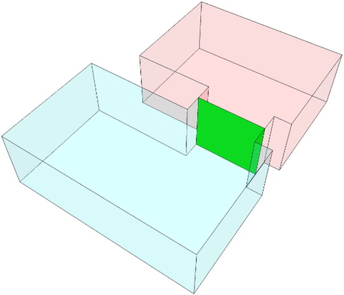
The 3D cadastral data model presented in this section is based on the result of the synthesis of the cadastral data models and considering the data model design objectives as presented below. As an alternative to other 3D cadastral data models, we focus on a building's indoor space as the core spatial unit. In this study, we define indoor space as the space that is bounded by the inward-facing three-dimensional surfaces (interior surfaces) of walls, floors, ceilings and other structural parts of the building. These spaces can be represented by 3D volumetric geometries, i.e. solids. At the passages between two indoor spaces, the solid geometries touch each other () aiming to integrate topologic relations between neighbouring spatial units.
Figure 1 The passages between indoor spaces are realised by touching surfaces (green)
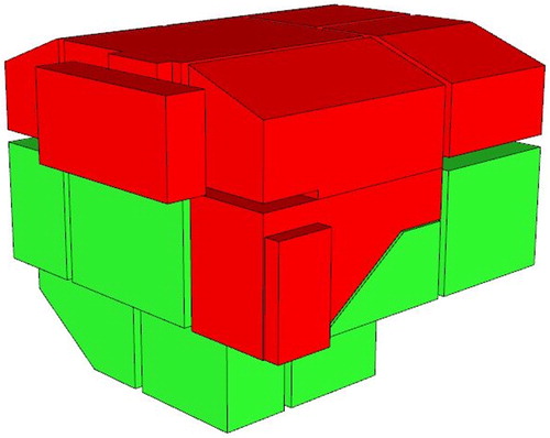
The boundaries of a real property unit (legal abstraction of the space) in the buildings may differ between jurisdictions, where we should distinguish, for example, the definition of a legal boundary which can coincide with the inward-facing or outward-facing surfaces of walls, floors, ceilings, and other structural parts of the building, or it might be defined in the middle of the wall, etc. (see also Cemellini et al. Citation2020). However, the possession or occupation of the physical space in a building is mainly related to indoor space. This makes it logical to focus on indoor spaces as core spatial units when modelling a building for RRR registration. Therefore, we define the real property unit as a group of indoor spaces (). The model is built on the presumption that for buildings, the indoor space represents a key object of interest for cadastral systems. The extension of these ‘basic spatial units’ can be applied in the sense of adding ‘wall solids’ (the whole width, half of the width, etc.).
Figure 2 Two real property units (red and green) represented by groups of spatially linked indoor spaces
In addition to being a feasible solution for the definition and geometric representation of a legal situation in the building, the indoor space also represents the most integrative object for cross-domain integration of building information with 3D cadastral data (Knoth et al. Citation2018).
Data model design
The development of the proposed cadastral data model has been guided by the objectives, identified by the authors, that are presented below. We believe that fulfilling these objectives is among the most important prerequisites to ensure an efficient system for 3D cadastral registration of buildings that is compatible with traditional 2D parcel-based cadastral systems.
The cadastral data model for buildings should not require storage and maintenance of the data outside the cadastral domain.
The cadastral data model should provide data that is structured in a way that enables as wide a cross-domain integration as possible on the data input and output sides.
The cadastral data model should differentiate building data from land parcel data (e.g. for buildings, it should provide a separate (but integrated) data model or separate object classes) aiming to provide a step-by-step development of a 3D cadastre within a traditional 2D data model.
The implementation should be feasible in a database management system (DBMS).
The first objective can be perceived as contradictory to our decision to focus on indoor spaces, but as it is stated in the justification for this decision, indoor spaces represent the main spatial units to which RRRs are related and provide less ambiguity in the representation of a legal situation in a building. However, following the first objective is challenging, as what belongs in the cadastral domain depends on the jurisdiction. Lemmen et al. (Citation2015) provide a list of fields related to but outside LADM, according to which physical registration of buildings is out of the LADM (cadastral) domain. On the other hand, much research shows that a very strong relationship exists between physical and legal space in the built environment (Aien et al. Citation2015, Li et al. Citation2016, Knoth et al. Citation2018). Larsson et al. (Citation2020) study the conversion of 2D analogue cadastral boundary plans into 3D digital information and discuss the integration with BIM. Rajabifard et al. (Citation2019) suggest that cadastral systems cannot and should not ignore the physical space, especially considering the second objective, which emphasises the multi-purpose role of the cadastre. The terms ‘physical space’ and ‘physical boundary’ used in this study refer to the real world and its physical features, while ‘legal space’ and ‘legal boundary’ refer to abstract space and its features that have legal meaning. There seem to be two options for cadastral systems regarding consideration of physical space.
Consider legal space in the cadastral model, as suggested by LADM (Lemmen et al. Citation2015): this way the first objective is fully met, but on the other hand, we lose the connection to physical space, which is crucial to have cross-domain data integration capabilities that constitute the essence of the second objective.
Use an integrative approach, based on several recent studies (Aien et al. Citation2015, Atazadeh et al. Citation2017, Oldfield et al. Citation2017, Thompson et al. Citation2017, Knoth et al. Citation2018, Atazadeh et al. Citation2019, Sun et al. Citation2019) following the second objective and make a trade-off by storing and maintaining data out of the cadastral domain.
However, there is a third, alternative approach, as proposed and used by this study. Instead of using one of the approaches presented above, we constrain the legal spaces with physical boundaries, giving them physical characteristics. More precisely, we constrain the boundaries of legal spaces (i.e. legal boundaries) to inward-facing surfaces of physical features (i.e. physical boundaries) that enclose indoor spaces. Many studies comprehensively deal with various possibilities of legal boundary position relative to physical objects in the building (middle of the wall, wall exterior or interior surface), which in essence depends on each country's legislation (Paulsson Citation2007). Wang (Citation2015) studies the boundary placement from a 3D visualisation perspective, Atazadeh et al. (Citation2017) and Rajabifard et al. (Citation2019) discuss the boundary placement in relation to BIM. Therefore, this approach seems to go against the established knowledge and thus requires further justification.
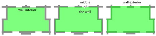
This paper does not intend to argue nor deal much with legal aspects of 3D cadastres, but rather provide a technical view on this matter. There is no doubt that in theory, a legal boundary can be established anywhere in space, not related to any physical features. However, when it comes to registering RRRs in buildings, the physical features become more important, which is also reflected in the number of studies dealing with this matter. Therefore, a legal boundary can lie either on the wall exterior, interior or somewhere in between. Atazadeh et al. (Citation2017) discuss these options while studying the purely legal, purely physical and integrated approaches for managing the RRRs for buildings. The purely legal approach excelled in visualisation and querying performance, but proved to be inappropriate for communication of boundaries relative to physical structures. Our model minimises this deficiency by constraining legal spaces to physical structures. aims to bring a common understanding of the terms wall interior, wall exterior and the middle of the wall for real property unit boundary placement in the context of this study. The same concepts can be found in the International Property Measurement Standards (IPMS Citation2020) that are developed to overcome the differences between countries regarding the rules for measuring the buildings. In general, if the real property unit boundary is defined by the wall interior surfaces, it does not contain any bounding walls. In contrast, if defined by the wall exterior, it contains all bounding walls. Besides these two cases, we add a case where the boundary is defined in the middle of the wall or anywhere between the inward-facing or outward-facing surfaces of walls; what's more, the boundary might be defined also as a buffer zone – in all these cases an indoor-space can still be used as a core spatial unit which is extended as defined by the law.
Figure 3 Options for real property unit boundary placement
Most jurisdictions worldwide use condominium (Paulsson Citation2007) to manage the RRRs, which is inherently connected with co-ownership since for buildings there are certain spaces that need to be owned by all individual owners (land parcel, common spaces and installations, etc.). The exterior and middle wall boundaries open up several issues and dilemmas regarding RRR management in the building (ownership is used as it represents the most important of the RRRs):
If a boundary of a real property unit is defined in the middle or exterior side of the wall, the wall is owned only by some of the owners. If the wall is statically important, this concerns all individual owners in the building.
If a boundary of a real property unit is defined in the middle of the wall, how is the ownership determined for outer walls that delineate the building interior and exterior?
If a boundary of a real property unit is on the exterior side of the wall, how is a boundary in complex situations defined ()?
If a boundary of a real property unit is defined in the middle or exterior side of the wall, how is the ownership of various installations in this wall determined?
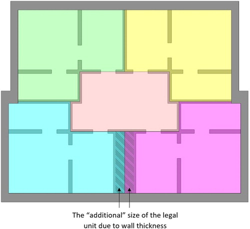
If walls have a various thickness and the boundaries of a real property unit are defined in the middle or exterior of the wall, identical physical units have different sizes of their respective real property units (). Should the subject of their ownership be different?
If a boundary is in the middle or exterior of the wall, is it the same with slabs? The slabs provide structural stability for the entire building and thus also concern all individual owners in the building.
Figure 4 Different variants of exterior boundary placement
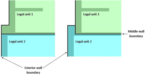
Figure 5 Various sizes of legal units, presented in different colours, for the same apartments (boundaries between real property units lie in the middle of the wall)
All listed dilemmas suggest that individual owners cannot fully exercise their ownership rights on the building structural parts but only on indoor spaces that are provided and made functional by the building structure. There are several legal solutions, for example, the definition of the object to which RRR refer in a contract, where building's structural parts might also be included. However, if we use interior wall surfaces as boundaries of real property units, we avoid the listed dilemmas and issues. This represents a similar concept as the IPMS 3C variant for measuring the buildings in the International Property Measurement Standards (IPMS Citation2020). Interior wall surfaces enclose indoor spaces which are used as a core spatial unit in our data model. The difference from the IPMS 3C is that the geometries of indoor spaces touch each other at passages, which means they are not exclusively bounded by physical structures.
Apart from already mentioned indoor spaces, the external building, can be characterised as an important entity for registration of RRRs on buildings. The external building geometry should enclose all indoor space geometries. It represents a key feature that delineates the building from the traditional continuous land parcel structure found in most land administration systems. Following the third objective, the model is designed to leave the traditional 2D parcel-based cadastral system mostly unchanged. For integration with 2D parcels, the ground contact area or maximal extent area (or both) of the building can be used. Depending on legal regulations, these areas are restricted to one parcel, form a parcel or can be independent of the parcel structure and only provide the information about the spatial extent of the building. These approaches are well established in most cadastral systems worldwide.
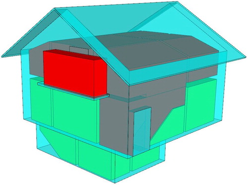
The pure concept of using indoor spaces and building external geometry, enclosing indoor spaces, becomes problematic when dealing with semi-indoor and semi-outdoor spaces that are partly connected to a building, but cannot be characterised as indoor space (). There are countless variants of these spaces (balconies, covered or semi-covered terraces, atriums, etc.). Yan et al. (Citation2019) provide a comprehensive study on this matter from a navigation perspective that illustrates that no clear boundary exists between indoor and outdoor space. The determination of what is part of a building and what is not is a general dilemma when dealing with RRR registration on buildings. Our proposed model can be used to register these spaces in a similar way as indoor spaces in Atazadeh et al. (Citation2017).
Figure 6 An example of the building geometry with legal amendment (balcony space)
Following the fourth objective, we have designed the implementation of the proposed model in the PostgreSQL DBMS with PostGIS and SFCGAL extensions. The database implementation represents a basis that can be further extended according to the specific needs of each jurisdiction. The selected DBMS supports 3D spatial data types, including solid geometries. Additionally, it offers functions that support the stored 3D data management and analyses.
Data model concept
Based on the objectives, we develop the data model concept (), defined by the main entities, their relations and their geometric representations. Compared to the data models that are referenced in section 2, our model can be perceived as basic. The reason for this is that this model is used to present and discuss the idea of using indoor spaces as the core cadastral data modelling entity, not to provide a complete and all-inclusive data model.
Figure 7 The concept of the proposed cadastral data model for buildings
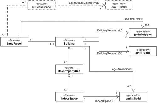
3D building modelling for cadastral purposes is the main focus of this paper. However, the presented concept also includes the relation to the land parcels and the optional relation to the 3D legal spaces, which are not defined by physical features. The proposed concept assumes that each building is associated with at least one real property unit, but this depends on the jurisdiction and can be altered. For buildings where no condominium is established, only basic data or no data is collected.
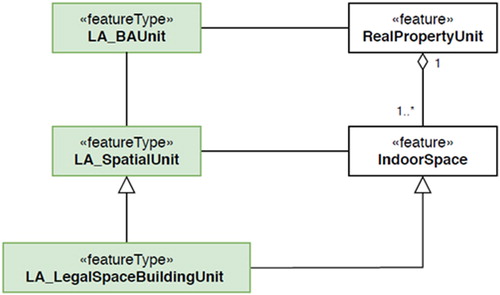
The data model is aligned with the LADM (). RealPropertyUnit is related to the LA_BAUnit class and IndoorSpace to LA_SpatialUnit and its subclass LA_LegalSpaceBuildingUnit. However, LADM explicitly denies the restriction of legal spatial units to the building's physical structures (Lemmen et al. Citation2015), which differentiates the two models. As the focus of the proposed data model is on indoor spaces, the solid representation of the geometry is selected as the most appropriate. It facilitates 3D representation, spatial analyses and provides volumetric information (Rajabifard et al. Citation2019), while LADM provides geometric representation of 3D geometries by boundary faces.
Figure 8 The relation of the proposed cadastral data model (white) and LADM (green) classes
Despite the differences, the proposed data model is partly compliant with the 3DCDM data model (Aien Citation2013) and the extended Core Model for 3D cadastre proposed by Knoth et al. (Citation2018). Both models use an integrative approach and represent physical features using multiple entities. However, if the same concept of using indoor spaces to define the real property units is used, the data models would be similar to the one that is proposed in the paper.
Results
DBMS implementation
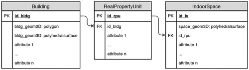
A DBMS represents the technical backbone of cadastral (information) systems worldwide. It provides an efficient way for secured storage and maintenance of cadastral data as well as for exploitation of cadastral data and information. Each new solution or upgrade of cadastral systems should, therefore, include or be supported by an advanced DBMS. Spatial data storage and maintenance are supported by the majority of DBMSs considering the ISO SQL/MM-Part 3 (ISO Citation2016) or OGC Simple feature access (OGC Citation2010), providing spatial data types, spatial indexes and operations that allow the geometry of the objects to be stored alongside their thematic attributes. The proposed cadastral data model is implemented using open source DBMS PostgreSQL with PostGIS and SFCGAL extensions, which support storage of polyhedral surfaces and solids, and offers functions to perform 3D operations. Three main tables () are used to represent three core features of the presented concept (Building, RealPropertyUnit and IndoorSpace).
Figure 9 DBMS implementation of the proposed cadastral data model
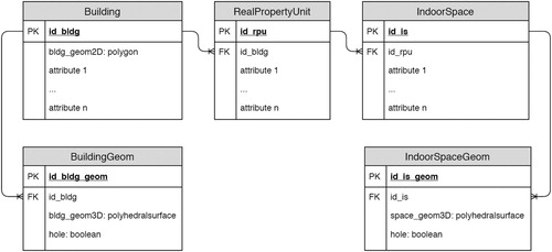
Although the selected DBMS supports storage of solids, the internal holes are not fully supported. The polyhedral surfaces can be stored with internal closed boundaries that form holes. However, 3D operations require solid geometries, obtained by the ST_MakeSolid. The polyhedral surfaces with an internal hole(s) cause the ST_MakeSolid function to crash with an invalid geometry error. This is not a problem in our case, as indoor spaces are bounded by physical structures. A hole in the indoor space would mean the physical structure would be detached and would ‘hover’ in space. The hole in indoor space could be created only by another indoor space that belongs to the other real property unit in the same physical indoor space. Similarly, the building external volumetric representation does not need internal holes, as an internal hole would still be indoor and not outdoor space. Despite this, we present the extension of the basic implementation that can accommodate holes in 3D solids. The database schema presented in introduces two new tables that can store several solid objects for one Building or indoor space representation. The hole Boolean type attribute indicates whether the geometry represents a hole.
Figure 10 DBMS implementation allowing storage of solids with holes
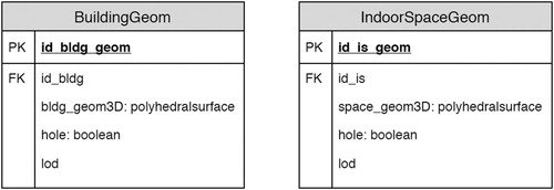
The CityGML standard widely introduced the concept of modelling of spatial entities in a 3D environment with multiple levels of detail (LOD). There are several benefits of this approach, such as efficient visualisation and data manipulation, and efficient spatial and other analyses that can also be identified as important by cadastral authorities. The extension () can accommodate multiple levels of detail for both indoor spaces and outdoor geometry by adding an attribute that identifies the corresponding level of detail for each geometry. The concept of multiple LODs is useful for cadastral authorities to store additional, more detailed data to further clarify the RRR situation in the building.
Figure 11 DBMS implementation allowing storage of multiple levels of detail
Data model integration
Registration of a building in the cadastral system, i.e. land administration system, represents one of the few available instruments for public authorities to obtain accurate, structured, relatively detailed spatial and thematic data about buildings, including data about the indoor environment, which is not accessible through remote sensing technology. Cadastral data has often been used for multiple purposes beyond its core one, partly so that the high costs of establishing and maintaining the system can be spread and justified, and partly because it has been the only available data source. If the cadastral data is structured so as to enable integration with data from other related domains, it can significantly increase its potential applications and consequently, its importance and value. Therefore, one of the most important objectives of our research has been to develop a cadastral data model for buildings that can be integrated with the dominant standards relating to 3D building modelling. The integration or at least linking is important to the data input side, i.e. to obtain data for registration from various data sources, and to the data output side, i.e. to include or use the 3D cadastral data in other models and increase the cadastral data usage/application potential.
Integration with IFC
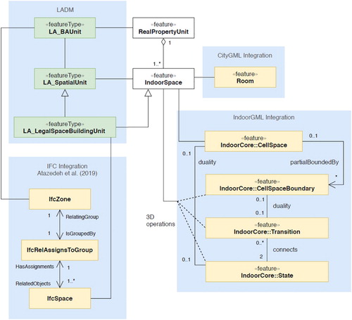
The importance of integrating land administration processes and BIM is increasing with the rapid adoption of BIM in the AEC industry. Several studies have already analysed various options for the integration of BIM and cadastral data (El-Mekawy and Ostman Citation2012, Liu et al. Citation2017, Oldfield et al. Citation2017, Rajabifard et al. Citation2018, Atazadeh et al. Citation2019, Rajabifard et al. Citation2019). All studies identified the IfcSpace as the most important class for the integration of IFC with RRR data. Atazadeh et al. (Citation2019) propose an approach that uses IfcSpace and IfcZone classes and is aligned with our modelling approach. The authors establish a link with LADM classes, by linking IfcSpace with the LA_LegalSpaceBuildingUnit class and IfcZone with LA_BAUnit (). This indicates that our proposed cadastral data model can be integrated with IFC data.
Figure 12 The concept of the integration of the proposed data model with the IFC, CityGML and IndoorGML standards
Integration with CityGML
CityGML is the dominant standard for 3D topographic modelling in the geospatial domain. The CityGML standard defines five LODs that increase in their geometric and semantic complexity. An interesting data model specification as an extension of LODs for detailed building modelling was proposed by Biljecki et al. (Citation2016), where a set of 16 LODs focused on the grade of the exterior geometry of buildings, while the indoor space was not discussed. Since the introduction of CityGML 2.0 in 2012, the standard has also been intensively studied from a 3D cadastral perspective. Çaǧdaş (Citation2012) proposed a CityGML extension for property taxation. Góźdź et al. (Citation2014) proposed an ADE for the CityGML standard to link it with LADM classes, which is further studied by Li et al. (Citation2016). The authors propose linking the LADM LA_LegalSpaceBuildingUnit class with a legal object class that is related to the BuildingPart and Building classes. Ying et al. (Citation2017) use CityGML LOD 3 models to construct volumetric objects, suitable for use in 3D cadastres.
As the core element of our model is indoor space, the corresponding class in CityGML is the Room class. Like the indoor space in our model, the Room class has a solid geometry representation (). However, the Room class can be included only in the LOD 4 model, where very detailed physical structures are required. Up to LOD 4, the CityGML standard does not provide an option to model the building interior. Boeters et al. (Citation2015) emphasise the need to include indoor geometries to lower levels of detail. The building geometry, on the other hand, can be better integrated with CityGML. Unlike the Room class, the _AbstractBuilding class is not restricted to specific levels of detail.
Integration with IndoorGML
Of the three standards considered in this section, the IndoorGML has the simplest data model. To avoid duplications, the standard allows linking with IFC and CityGML. The main role of IndoorGML is to provide a data model for indoor navigation purposes. Zlatanova et al. (Citation2016) and Alattas et al. (Citation2017) studied the link between LADM and IndoorGML to provide additional information about indoor spaces which can improve indoor navigation performance. Rajabifard et al. (Citation2018) discussed the options for linking IndoorGML with LADM and concluded that IndoorGML cells could be used to define the geometry of legal spaces. To realise this, the authors emphasise the need for investigation of complex 3D spatial analyses. Our approach is very similar, and we addressed the need for 3D spatial analyses by implementing the model in PostgreSQL with PostGIS and SFCGAL extensions that provide state-of-the-art DBMS support for 3D spatial operations.
As in the proposed model, the core element of the IndoorGML data model is the indoor space (CellSpace class), which makes the two very aligned and interoperable in this aspect (). Following the duality concept, the IndoorGML data model contains navigation graph elements – nodes and edges (State and Transition elements), which are not included in the proposed cadastral data model. The indoor space geometries in the proposed model touch each other on the surfaces that represent the passage between them (doors and other openings). This makes it possible to derive the indoor space topology from geometries using 3D operations available in the selected DBMS. If the physical indoor space is divided into several touching indoor spaces belonging to different real property units, these can be used to perform subspacing of IndoorGML CellSpace entities.
Discussion
The legal frameworks that regulate the registration of RRRs on buildings differ very much among the countries and jurisdictions. The data model is focused on the definition of real property units using indoor spaces, independently on the legal definition of a real property unit. As already mentioned, the legal regulations do not require the borders of the real property units to coincide with the borders of indoor spaces. Therefore, the proposed data model cannot be directly introduced and implemented without amendments of the legal framework or the proposed data model. The proposed data model can be amended with an additional entity, which represents the building's physical features. These features are linked to the corresponding real property unit the same way as indoor spaces. Using this amendment, the model can support all types of boundaries of real property units within the buildings, while still allowing the presented geospatial data integration options. On the other side, the legal frameworks can also be amended to increase the compatibility with the presented data model. These amendments are mostly related to the definition of the RRRs on the physical features of the building (walls, slabs, etc.). One option is to define that all the physical structures of the building are owned by all the owners, if not additionally defined differently. Another option is to define that the physical structures between two indoor spaces of the same real property unit also belong to this real property unit. The physical structures between two indoor spaces of different real property units can be defined as owned by both owners, or owned by each owner to the middle. The data model can also be modified to allow the modelling of only the outer boundaries of the real property units. The geometry of the real property unit can be defined as a union of all adjacent indoor spaces belonging to the same real property unit, also containing all physical structures of the building. In case the indoor space geometries would be sourced from the BIM entities, this union should be done additionally using 3D modelling software. If the indoor spaces are modelled based on measurements, then all the spaces of the same real property unit can be joined into one 3D geometry representing the extent of the real property unit. However, this would reduce the options for integration with other data models and consequentially the options to use the cadastral data for other purposes.
One of the challenging topics regarding RRR registration on buildings and parts of buildings within a 3D cadastre is the required geometric accuracy as well as the level of detail of the geometric data model. This research does not deal with this issue apart from allowing storage of multiple levels of detail. If the boundaries of legal spaces coincide with physical boundaries, the required accuracy is not as high as it is for boundaries with no physical counterpart. In the future, the BIM models will provide very detailed data on the building's physical elements for more and more buildings. The integration, as presented in this study, will therefore be very beneficial. The current problem is that many IFC models do not provide as-built data, essential for cadastral registration.
The developed data model is based on indoor spaces that are touching each other at passages, which means that 3D geometries of indoor spaces have shared faces. The proposed database implementation uses the polyhedral surface to represent each indoor space, which means the ‘touching’ faces are duplicated. Consequently, the required storage space is increased. Additionally, the duplication can cause the data to be inconsistent. However, this approach has several advantages over storing 3D geometries using the topological data structure.
The 3D geometries can be managed by the available database 3D functionalities.
We have direct access to 3D geometries, without the need to construct 3D geometries using lower-dimensional geometrical features and their topological relationships.
The 3D geometries can be stored in line with other attribute data.
The inconsistencies should be avoided by automatically checking the data at insertion and each manipulation of geometry. The PostgreSQL DBMS with PostGIS and SFCGAL extensions has functionalities to implement some data validation as an overlapping check also in 3D.
The open question for cadastral building registration is which buildings to include. While in many countries detailed cadastral registration is foreseen only for buildings where a condominium is to be established, some countries, e.g. Slovenia and Sweden (see Drobež et al. Citation2017, Larsson et al. Citation2020), register all buildings, mainly for efficient real property valuation that serves many governmental applications. In this case, the indoor spaces have to be measured to obtain the area information. With some additional vertical measurements, it is possible to obtain enough information for 3D modelling of the indoor spaces according to the proposed data model. This also opens new possibilities for valuation as we obtain not only area but also the volume of the indoor spaces.
For the buildings with no established condominium, all indoor spaces can be grouped into one real property unit. Following this concept, also these buildings can be modelled according to the proposed data model. If the cadastral system registers only the buildings with multiple real property units, only some basic data may be registered about the other buildings (e.g. external geometry) or they can be entirely left out. The buildings having multiple real property units can be modelled according to the proposed data model.
However, it should be noted that the developed concept and data model is in accordance with the current practices of RRR registrations on parts of buildings, e.g. condominiums, based on floor plans.
Storing detailed data on the interior of buildings can be problematic from a privacy and security aspect. This can be efficiently managed by making parts of the data (indoor spaces) available only to authorised users. Given that the proposed model offers data that can be used for many applications, including public safety, crisis and disaster response by police, firefighters, ambulance and other first responders, the benefits should outweigh the concerns.
Conclusions
In our study, we look for generic solutions to 3D cadastral building modelling that would be suitable for deployment in various jurisdictions. The idea of using indoor spaces constrained to physical features as the core element for cadastral registration of buildings is used for 3D cadastral modelling. Using the indoor space as the core spatial unit differentiates the research presented here from other related studies that have included indoor spaces in the data models. The model design process is thoroughly discussed, with references to the initial objectives used to steer and guide the model design process. The contribution of this study can also be perceived in the presentation of a complete design process from initial idea to DBMS implementation. The aim of the study has not been to reject all the proposed 3D cadastral models and research in this field, but to provide an alternative data modelling approach. The data model is designed to be aligned with the LADM standard and standards related to physical modelling of buildings. This means it enables and facilitates the integration of cadastral data with the data from other related domains, which is becoming increasingly important. It can be considered and applied by the cadastral authorities in revising or designing new cadastral data models with objectives aligned with the ones presented in this paper.
Disclosure statement
No potential conflict of interest was reported by the author(s).
Additional information
Funding
Notes on contributors
Jernej Tekavec
Jernej Tekavec graduated from the University of Ljubljana, Faculty of Civil and Geodetic Engineering (UL FGG) in the field of geodesy. Currently, he is employed as assistant researcher at the Chair of Geo-informatics and Real Estate Cadastres, UL FGG, and is a PhD candidate at the same faculty. His research is focused on real estate cadastres, 3D city and indoor modelling, and 3D spatial analyses. He is actively involved in current national and international projects and activities of the chair. As an early stage researcher, he has also participated in various international workshops, forums and conferences from the geospatial and land administration domains.
Marjan Čeh
Marjan Čeh is assistant professor at the Chair of Geo-informatics and Real Estate Cadastres at the University of Ljubljana, Faculty of Civil and Geodetic Engineering (UL FGG), Slovenia. His main research interests are in the field of semantic interoperability and ontology, geometric improvement of cadastral maps, strategic development of Land Administration Systems, analyses of spatial data infrastructure, mass appraisal of real estate. He is in charge of several projects financed by the Surveying and Mapping Authority of Republic of Slovenia. At the international level, he has contributed to several projects, such as COST actions, Tempus projects, ESPON, FP7 and Horizon2020 project, and is actively involved in many international initiatives, such as EuroSDR, OGC.
Anka Lisec
Anka Lisec is associate professor and head of the Chair of Geo-informatics and Real Estate Cadastres at the University of Ljubljana, Faculty of Civil and Geodetic Engineering (UL FGG), Slovenia. Her research interests are focused on geoinformatics and spatial information systems, including land administration systems, with a particular focus on 3D&4D geospatial data modelling and 3D cadastre. At the international level, she is actively involved in many international exchange programmes, associations and initiatives in geospatial and land administration domains. With her research, coordinating and knowledge-transfer activities, she has contributed to several international projects, such as COST actions, Tempus projects, ESPON, FP7 and Horizon2020 project. Beside her research work within national and international projects, she is actively involved in the preparation of cadastral legislation as well as in developing strategic guidelines for the national mapping and surveying service.
References
- Aien, A., 2013. 3D cadastral data modelling. Thesis (PhD). Melbourne, Victoria: University of Melbourne.
- Aien, A., et al., 2015. Integrating legal and physical dimensions of urban environments. ISPRS international journal of geo-information, 4 (3), 1442–1479. doi: 10.3390/ijgi4031442
- Alattas, A., et al., 2017. Supporting indoor navigation using access rights to spaces based on combined use of IndoorGML and LADM models. ISPRS international journal of geo-information, 6 (12), 384. doi: 10.3390/ijgi6120384
- Alattas, A., et al., 2020. LADM-IndoorGML for exploring user movements in evacuation exercise. Land Use Policy, 98, 104219. doi: 10.1016/j.landusepol.2019.104219
- Atazadeh, B., et al., 2019. Querying 3D cadastral information from BIM models. ISPRS international Journal of Geo-information, 8 (8), 329. doi: 10.3390/ijgi8080329
- Atazadeh, B., Rajabifard, A., and Kalantari, M., 2017. Assessing performance of three BIM-based views of buildings for communication and management of vertically stratified legal interests. ISPRS international Journal of Geo-information, 6 (7), 198. doi: 10.3390/ijgi6070198
- Biljecki, F., Ledoux, H., and Stoter, J., 2016. An improved LOD specification for 3D building models. Computers, environment and urban systems, 59, 25–37. doi: 10.1016/j.compenvurbsys.2016.04.005
- Boeters, R., et al., 2015. Automatically enhancing CityGML LOD2 models with a corresponding indoor geometry. International journal of geographical information science, 29 (12), 2248–2268. doi: 10.1080/13658816.2015.1072201
- Çaǧdaş, V., 2012. An application domain extension to citygml for immovable property taxation: a Turkish case study. International journal of applied earth observation and geoinformation, 21 (1), 545–555. doi: 10.1016/j.jag.2012.07.013
- Cemellini, B., et al., 2020. Design, development and usability testing of an LADM compliant 3D cadastral prototype system. Land use policy, 98, 104418. doi: 10.1016/j.landusepol.2019.104418
- Deng, Y., Cheng, J.C.P., and Anumba, C., 2016. Mapping between BIM and 3D GIS in different levels of detail using schema mediation and instance comparison. Automation in construction, 67, 1–21. doi: 10.1016/j.autcon.2016.03.006
- Drobež, P., et al., 2017. Transition from 2D to 3D real property cadastre: the case of the Slovenian cadastre. Computers, environment and urban systems, 62, 125–135. doi: 10.1016/j.compenvurbsys.2016.11.002
- El-Mekawy, M., 2010. Integrating BIM and GIS for 3D city modelling; The case of IFC and CityGML. Thesis (PhD). Stockholm: Royal Institute of Technology – KTH.
- El-Mekawy, M. and Ostman, A., 2012. Feasibility of building information models for 3D cadastre in Unified city models. International journal of e-planning research, 1 (4), 35–58. doi: 10.4018/ijepr.2012100103
- FIG 3D Cadastres. 2019. Website of FIG joint commission 3 and 7 working group on 3D cadastres. Available from: http://www.gdmc.nl/3dcadastres/ [Accessed 1 Mar 2020].
- Góźdź, K., et al., 2014. The possibilities of using CityGML for 3D representation of buildings in the cadastre. In International workshop for 3D cadastres. Dubai.
- IPMS, 2020. International property measurement standards. Available from: https://ipmsc.org/standards/ [Accessed 8 Oct 2020].
- ISO, 2012. ISO 19152:2012 – geographic information – land administration domain model (LADM). Geneva, Switzerland: International Standard.
- ISO, 2016. ISO/IEC 13249-3:2016. information technology – database languages – SQL multimedia and application packages – part 3: spatial. Geneva, Switzerland: International Standard.
- ISO, 2018. ISO 16739-1:2018. Industry Foundation Classes (IFC) for data sharing in the construction and facility management industries. Geneva, Switzerland: International Standard.
- Knoth, L., et al., 2018. Cross-Domain building models—A step towards interoperability. ISPRS International journal of geo-information, 7 (9), 363. doi: 10.3390/ijgi7090363
- Larsson, K., Paasch, J.M., and Paulsson, J., 2020. The land administration domain model. Land use policy, 98, 104178. doi: 10.1016/j.landusepol.2019.104178
- Lemmen, C., van Oosterom, P., and Bennett, R., 2015. The land administration domain model. Land use policy, 49, 535–545. doi: 10.1016/j.landusepol.2015.01.014
- Li, L., et al., 2016. 3D modeling of the ownership structure of condominium units. Computers, environment and urban systems, 59, 50–63. doi: 10.1016/j.compenvurbsys.2016.05.004
- Liu, X., et al., 2017. A state-of-the-art review on the integration of building information modeling (BIM) and geographic information system (GIS). ISPRS International journal of geo-information, 6 (2), 53. doi: 10.3390/ijgi6020053
- OGC, 2010. Open geospatial consortium. Implementation specification for geographic information – simple feature access – part 2: SQL option. Available from: https://www.opengeospatial.org/standards/sfs [Accessed 1 Mar 2020].
- OGC, 2012. Open geospatial consortium. City Geography Markup Language (CityGML) encoding standard, version 2.0. Available from: http://www.opengeospatial.org/standards/citygml [Accessed 1 Mar 2020].
- OGC, 2014. Open geospatial consortium. IndoorGML, version 1.02. Available from: http://www.opengeospatial.org/standards/indoorgml [Accessed 1 Mar 2020].
- Ohori, K.A., et al., 2018. Processing BIM and GIS models in practice: experiences and recommendations from a GeoBIM project in The Netherlands. ISPRS International journal of geo-information, 7 (8), 311. doi: 10.3390/ijgi7080311
- Oldfield, J., et al., 2017. Working with open BIM standards to source legal spaces for a 3D cadastre. ISPRS International journal of geo-information, 6 (11), 351. doi: 10.3390/ijgi6110351
- Paasch, J.M., et al., 2016. Building a modern cadastre: legal issues in describing real property in 3D. Geodetski vestnik, 60 (2), 256–268. doi: 10.15292/geodetski-vestnik.2016.02.256-268
- Paulsson, J., 2007. 3D property rights – an analysis of key factors based on international experience. Thesis (PhD). Stockholm: Royal Institute of Technology – KTH.
- Rajabifard, A., Atazadeh, B., and Kalantari, M., 2018. A critical evaluation of 3D spatial information models for managing legal arrangements of multi-owned developments in Victoria, Australia. International journal of geographical information science, 32 (10), 2098–2122. doi: 10.1080/13658816.2018.1484125
- Rajabifard, A., Atazadeh, B., and Kalantari, M., 2019. BIM and urban land administration. Boca Raton: CRC Press. doi: 10.1201/9781351032346
- Rönsdorf, C., Wilson, D., and Stoter, J., 2014. Integration of land administration domain model with CityGML for 3D cadastre. In International workshop on 3D cadastres. Dubai.
- Shojaei, D., 2014. 3D cadastral visualisation: understanding user’s requirements. Thesis (PhD). Melbourne, Victoria: University of Melbourne.
- Sun, J., et al., 2019. Utilising BIM and GIS for representation and Visualization of 3D cadastre. ISPRS International journal of geo-information, 8 (11), 5013. doi: 10.3390/ijgi8110503
- Tekavec, J., and Lisec, A., 2020. Cadastral data as a source for 3D indoor modelling. Land use policy, 98, 104322. doi: 10.1016/j.landusepol.2019.104322
- Thompson, R., van Oosterom, P., and Soon, K., 2017. LandXML encoding of mixed 2D and 3D survey plans with multi-level topology. ISPRS International journal of geo-information, 6 (6), 171. doi: 10.3390/ijgi6060171
- van Oosterom, P., et al., 2018. 3D cadastral information modelling. In: P. van Oosterom, ed. 3D cadastres best practices. Copenhagen, Denmark: International Federation of Surveyors – FIG, 95–132. Chapter 3.
- van Oosterom, P., 2018. Best practices 3D cadastres. Copenhagen, Denmark: International Federation of Surveyors – FIG.
- van Oosterom, P., et al., 2019. Joint ISO/TC211 and OGC revision of LADM: valuation information, spatial planning information, SDG land indicators, refined survey model, links to BIM, support of LA processes, technical encodings, and much more on their way! FIG Working Week 2019: Geospatial Information for a Smarter Life and Environmental Resilience.
- Wang, C., 2015. 3D Visualization of cadastre: assessing the suitability of visual variables and enhancement techniques in the 3D model of condominium property units. Thesis (PhD). Québec: Université Laval.
- Yan, J., Diakité, A.A., and Zlatanova, S., 2019. A generic space definition framework to support seamless indoor/outdoor navigation systems. Transactions in GIS, 23 (6), 1273–1295. doi: 10.1111/tgis.12574
- Ying, S., et al., 2017. 3D space shift from CityGML LoD3-based multiple building elements to a 3D volumetric object. ISPRS International journal of geo-information, 6 (1), 17. doi: 10.3390/ijgi6010017
- Zlatanova, S., et al., 2016. Ladm and indoorgml for support of indoor space identification. ISPRS annals of photogrammetry, remote sensing and spatial information sciences, IV-2/W1(October), 257–263. doi: 10.5194/isprs-annals-IV-2-W1-257-2016