
ABSTRACT
For future landscapes to be sustainable, significant changes in land-use and management practices will be needed. This article argues that landscape archaeology can make distinctive contributions to sustainability in two ways: firstly, by researching what were and were not sustainable ways of life in the past, and secondly by using this knowledge to explain how landscapes of the past differed to those in the present, and in doing so to disrupt the invented connections between past societies, tradition, heritage and conservation. The article draws on three case-studies in China, the Mediterranean and the UK to suggest that archaeological knowledge could be used to help stakeholders imagine future landscapes which are better and more sustainable than those of today. To succeed archaeologists will need to make deeper commitments to transdisciplinary work.
Landscapes must change. It is one of their fundamental characteristics, experienced everyday at scales from diurnal rhythms, through the revolution of the seasons, to the passage of life and death. This basic quality is recognized not only in the scholarly literature (e.g. Bürgi, Hersperger, and Schneeberger Citation2004), but also in policies and international treaties like the European Landscape Convention (ELC) (CoE Citation2000). Landscape as a transdisciplinary concept has much value in the context of sustainability, since it considers the relationships between people and the environment as a whole (Fairclough Citation2019), rather than trying to understand them as separate systems which interact with each other (Carpenter et al. Citation2009; Colding and Barthel Citation2019). Landscape comprises all types of places (rural, urban, peri-urban, coastal and maritime) and qualities (everyday, derelict, protected); it relates directly to key issues such as governance and justice, social and ecological health and wellbeing, place attachment and meanings, and environmental change. Working through a landscape perspective is therefore relevant to a wide range of social and environmental challenges (Shuttleworth Citation2018).
Over recent decades part of the public debate has shifted significantly towards recognizing that change can be not only beneficial but also necessary. Young people protest about the climate crisis and force governments to make landmark decisions (for example the demise, now foreseen, of the internal combustion engine); the ‘rewilding’ movement emphasizes the massive potential benefits for wildlife, ecology and society of less intensive land-use and of rewarding landowners for curating the environment rather than producing food at artificially low prices (Tree Citation2018); new technologies like solar and wind enable the sun’s energy to be harnessed in less and less destructive ways. But in spite of such trends, defensive and reactive notions of ‘conservation’ and ‘preservation’ remain powerfully embedded in the shared imagination of many societies and the policies of governments and international organizations (Meskell Citation2018). Tensions between older, monument-focussed systems of heritage management and newer approaches which see heritage as negotiated, ubiquitous and dynamic are palpable in guidelines like UNESCO’s recommendation on Historic Urban Landscapes (Citation2011) or the ICOMOS Outline on Heritage and Climate Change (Citation2019). Indeed, a similar tension can be identified in ideas relating to sustainability, including ‘sustainable development’ (Dessein et al. Citation2015). Are these concepts concerned with sustaining something from the past, or creating something which can be sustained in the future?
In many ways it still seems easier to engage the public with the world’s ecological and cultural wellbeing on an emotional level in terms which evoke loss – or things that will soon be lost – in the vortex of negative change. Campaigners for cultural heritage frequently appeal to nostalgia for (imagined) past cultures (Whitehead et al. Citation2019); in advocating movement towards more sustainable lifestyles ‘re’-wilding is promoted as a way to ‘re’-create landscapes that are better because they are more ecologically diverse – like the ones that existed sometime in the past (Jepson and Blythe Citation2020). A key problem – of which all landscape archaeologists are acutely aware – is that it is impossible to go backwards, and if it were, to what period? Landscapes disrupted through urbanization, industry or mining cannot simply be returned to a former, pristine state; even fields abandoned for hundreds of years bear tell-tale signs of their old uses, both in their physical form and their ecology (Latocha Citation2015; Latocha et al. Citation2019). Climate change would likely also hinder ‘regression’ of landscapes towards earlier states (Richmond et al. Citation2010; Jarvie and Svenning Citation2018). Landscapes change through natural processes but also because societies themselves are constantly active and dynamic. Archaeologists interpret how landscapes used to function, but today’s societies and their needs are different. The sustainable solutions which were developed by past societies were built for different situations. They cannot simply be discovered and deployed by archaeologists to solve problems now: things have changed. To shift the direction of change onto a positive trajectory requires action that is suited to the new context. Such action needs to be framed within all three of the conventional ‘pillars’ of sustainability (social, economic and environmental), but perhaps above all in a fourth, the all-encompassing sphere of ‘culture’ (Dessein et al. Citation2015).
Over the last decade archaeologists have begun to catalogue the discipline’s potential to contribute to future sustainability (Guttman-Bond Citation2010, Citation2014, Citation2019; Fisher Citation2020), and even to outline manifestos for action (e.g. Sinclair, Barthel, and Isendahl Citation2019). Examples like the UK’s programme of historic landscape characterization show how archaeological knowledge can be used to inform landscape management and planning. At the local level, historic characterizations provide data which support more sustainable land management under government-funded agri-environment schemes. At larger scales, the same data are used to inform both the landscape design and impact mitigation strategies developed for large-scale construction projects including major roads and other infrastructure (Turner Citation2018). Landscape archaeology projects which engage communities in co-production of research can also contribute to social sustainability by supporting inclusion and community cohesion (Lewis Citation2017). On the whole, though, archaeologists have not engaged deeply with sustainability and the number of examples where archaeological research has demonstrably contributed to improving outcomes remains small.
There are various reasons for this: a disciplinary focus on past societies is probably one, and relatively weak engagement with policy makers another (Rockman and Hritz Citation2020). To address sustainability, it is crucial to go further towards a transdisciplinary approach where multiple stakeholders – public bodies, businesses, community members, scientists – come together to address problems (Nilsson Stutz Citation2018; Dymitrow and Ingelhag Citation2020; Moore, Guichard, and Sanchis Citation2020; Kristensen and Primdahl Citation2020). In this way, existing knowledge can be harnessed or new co-productive research can be designed to feed into effective and far-reaching strategies and decisions. Landscape archaeologists have roles to play and voices to use, but it is pretty clear they will not solve any global challenges by working on their own (Richer, Stump, and Marchant Citation2019; Fairclough et al. Citation2020). Nevertheless, the knowledge created through landscape archaeology has great potential to inform solutions to global challenges, not only by illuminating the stories of past landscapes, but by using those narratives to influence actions, attitudes and opinions.
This article argues that landscape archaeology can make particular and distinctive contributions to creating sustainable landscapes. To do so requires two steps. The first is to create knowledge about the strategies which were and were not sustainable in the past. The second is to use this knowledge to explain to partners and stakeholders how past landscapes differed to those of today, and in so doing to disrupt the connections which have been constructed between past societies and modern narratives of tradition and conservation. By doing this, archaeologists could provide and help to legitimize scenarios that might enable stakeholders to imagine future landscapes that are better and more sustainable than those we have today.
The importance of valuing approaches other than technology-driven, industrial production is well established in the international agriculture and development literature: the enormous value of ‘intermediate’ or ‘appropriate’ technologies such as agroecology (for example, to food security) is widely recognized and promoted (e.g. HLPE Citation2019). Similarly, international agencies support the recognition of landscape heritage for sustainability through schemes like UNESCO’s World Heritage or Memory of the World registers and the FAO’s Globally Important Agricultural Heritage Systems (FAO Citation2018). These initiatives identify specific examples of systems underpinned by ‘traditional ecological knowledge’ (or ‘indigenous knowledge’) which are typically linked to well-preserved historic landscapes and heritage practices in particular locations. Whilst these heritage landscapes have very great value, their contribution to sustainability is not the same as the potential contribution of landscape archaeology. Although ‘traditional’ and ‘indigenous’ knowledge are frequently conflated with historical practices (Stump Citation2013), they do not represent unbroken continuums with the past. The landscapes we have today are the result of myriad processes and practices which have changed in step with the societies who have inhabited them. Although both physical features and practices can persist from the past, their social value and practical uses change over time. Humans have re-shaped their landscapes so many times, with change accelerating rapidly through the Neolithic, industrial and information revolutions (Lyons et al. Citation2016), that it is rarely (if ever) possible to identify completely unchanging practices which extend back beyond the 20th century, let alone into prehistory. ‘Traditional’ and ‘indigenous’ knowledge, whilst of enormous value, are not the same thing as knowledge of past practices produced through archaeological research. Ask a housebuilder in the UK today how to build a ‘traditional’ house and more likely than not they will say with steel, bricks and concrete blocks (Monahan and Powell Citation2011), as opposed to technologies tested over millennia like timber framing, earth and straw, or lime mortar (Barley Citation1961; Forster et al. Citation2008). While tradition and heritage are living phenomena of the present, they are not necessarily accurate representations of the past, and they do not necessarily help us to understand how, why or when changes happened in past societies. Identifying such changes, together with their causes and impacts, requires an archaeological approach.
Following on from the discovery and interpretation of data from different contexts, archaeological knowledge facilitates the creation of scenarios about past landscapes which are freed from the constraints of tradition and heritage. Landscape archaeologists are consequently well-positioned to inform the questioning of established historical and environmental narratives, and to encourage dialogues and debates which can reshape attitudes to landscape change. Landscape narratives based on archaeological research could provide spaces less encumbered by the emotional baggage and nostalgic yearnings of much heritage discourse (Whitehead et al. Citation2019). Explaining and sharing insights from landscape archaeology could provide ways to legitimize recognition of the potential for change: it gives scope for participants and stakeholders to see that landscapes of the future could be different to those of the present precisely because people in past landscapes often chose radically different strategies. Archaeology also affords recognition that through the course of history (and prehistory) landscapes have changed for the worse as well as for the better; it can therefore support the idea that what exists today or in the past is not necessarily as good or as sustainable as what might be created in future.
To maximize positive outcomes it will be crucial to work together with stakeholders and the public in order to inform broader understanding of landscape change and its potential directions (Dessein et al. Citation2015; Richer, Stump, and Marchant Citation2019; Moore, Guichard, and Sanchis Citation2020). Future sustainability also depends on the realization that landscapes will have many functions and will be valued in different ways by different people. In a world where nearly 70% of the population is expected to live in cities within 30 years (UN Citation2019), rural landscapes will have to accommodate the needs of urban societies. These will include not only environmental benefits (flood prevention, provision of clean water, supporting ecological diversity) but also wellbeing benefits – for example providing time and space for leisure and recreation. Archaeological knowledge has the potential to underpin the equitable access to landscape as a common good which links urban and rural communities, thus contributing in a substantial way to future social justice (Lekakis Citation2020). In pursuit of these goals the arguments for archaeologists to contribute through transdisciplinary approaches which link together actors from many communities of interest are not only compelling but unavoidable.
Three short examples will serve to illustrate some of these issues and point towards potential contributions by landscape archaeologists.
Settling (or unsettling) China’s desert frontier
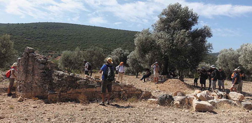
In the desert province of Gansu, at what was once the north-west extremity of Ming China, lies the town of Jiayuguan. It is here that the Ming Great Wall ends against the gorge of the Beida River and the low range of the Black Mountains, and also where it intersects with the ancient ‘Silk Road’ from Central Asia: Jiayuguan controls access along the Hexi Corridor north of the Qilian Mountains, the main overland route from China towards the west. A city of around 250,000 people has grown rapidly since 1958 (Ren et al. Citation2020), dependent initially on steel and mineral extraction. Over the last decade changing economic prospects and the environmental degradation associated with these traditional industries have led to increasing diversification. Since 1997 Jiayuguan has been home to one of Asia’s largest vineyards (a spin-off from the steel company), and tourism has become a top priority (Lu et al. Citation2018). The city’s principal attraction is a great fourteenth-century fortress built to control the Jiayu pass, although the desert landscape has been occupied for much longer (). In the narrow defiles of the Black Mountains, Buddhist rock-art of the first millennium CE provides testimony to the movement of religious ideologies along the Silk Road from the west; just east of Jiayuguan hundreds of elaborate burials of the Wei and Jin Dynasties (third-sixth centuries CE) are evidence of a flourishing society whose agriculture and industry (including silk production) are depicted on painted tiles in the tombs. During the Han period (third c. BCE-third c. CE) the military frontier extended for over 1000 km further west through Dunhuang and into the Taklamakan desert beyond, with towns and military infrastructure supported initially by soldier-farmers (tuntian). They brought land under irrigated cultivation which continued to be used into the Tang period (Luo et al. Citation2017).
Figure 1. The view north from the medieval fortress at Jiayuguan towards the Black Mountains, looking directly south to north across the centre of the area shown in (photo: Sam Turner, November 2019)
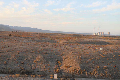
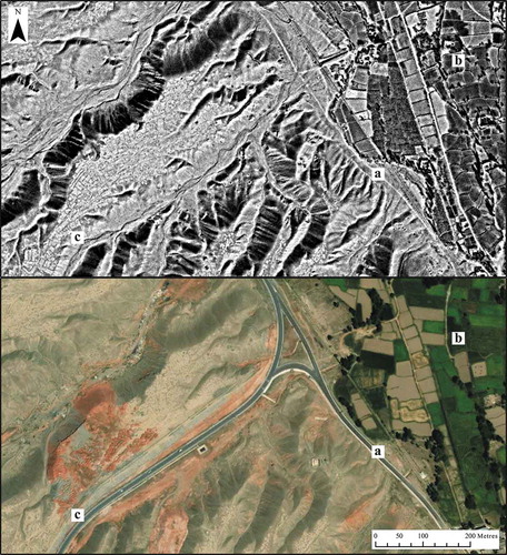
Figure 2. Satellite imagery from October 1972 (top) and August 2019 depicting an area where the Ming Great Wall cuts through earlier field systems (a), field system rationalization (b), and nearby relict field systems excluded by the Ming Wall (c). Image source: KH-9 HEXAGON Mission 1204, 14 October 1972, acquired from the United States Geological Survey (top). Google Earth/Maxar Satellite Imagery, 14 August 2019 (bottom). (Illustration: Christopher Sevara)
The principal source of water for agriculture in western Gansu and neighbouring regions comes not from rain but from seasonal meltwater out of the mountains. The technical and agricultural ramifications of environmental change in north-west China for the management and use of seasonal water supplies have not been fully explored (Ma et al. Citation2008; Qin et al. Citation2012); the impact on demography and settlement patterns is consequently uncertain (Mischke et al. Citation2019). Whilst the population of most of northern China remained relatively stable in the first millennium CE, during dry periods farmers might have been forced northwards from central China, displaced by pastoralists moving down from the steppes (Pei et al. Citation2019). However, the extent to which irrigation systems created in the Han period were maintained in later centuries, and indeed the ways they differed from smaller-scale agropastoralist irrigation remains unexplored because the latter have generally been ignored. This neglect is bound up with methodological, historiographical and ideological issues, including assumptions about the technological superiority of state actors like the Han soldier-farmers. By contrast, recent research at Mohuchahangoukou in Xinjiang suggests that appropriate technologies implemented by agropastoralists from the third or fourth centuries CE may have originated in Central Asia and that their introduction may have been related to – and supported – long-distance communications on the ancient ‘Silk Road’ (Li et al. Citation2017; Bertrand Citation2012; Høisæter Citation2017). The karez water-harvesting systems around the city of Turpan, 800 km north-west of Jiayuguan, provide an illustrative example. The karez are equivalents of the ancient Persian and Middle Eastern qanat and North African foggara systems (Stein Citation1933; Cressey Citation1958). Studies based on historical sources have typically suggested either that the karez were an independent innovation brought from central China during the Han period, or an introduction of the Qing dynasty during the eighteenth or ninteenth century CE (Trombert Citation2008, 117). The possibility that the technology was implemented by local Uyghur societies was rarely considered until a recent programme of radiocarbon dating showed that various karez around Turpan were first built in the fifteenth and sixteenth centuries CE (Mächtle et al. Citation2019).
At Jiayuguan the effect of the fluctuating military frontier on desert settlement remains to be defined. So far scholars have relied on documentary sources with little archaeological research: few scientific dates have been obtained from either frontier works or irrigation systems. It seems clear that from Han times onwards the frontier was designed to include cultivated areas supported by major irrigation systems, for example extending north along the Heihe River from Jiuquan to the forts at Xidawan and Dondawan. But these were not the only way to farm the desert and other, smaller-scale, systems may have been more appropriate in many contexts. Around Jiayuguan remote sensing data shows that the Ming Great Wall also cuts through earlier field systems. Many were rationalized in the later twentieth century, but historic satellite images reveal their earlier, more irregular form (). Other nearby field systems on a similar scale to those at Mohuchahangoukou are excluded entirely by the Ming Wall; they were supplied with water through channels which are now dry and abandoned. These smaller-scale technologies remain unstudied around Jiayuguan and in many other places where the monumental heritage of the Great Wall has dominated research agendas. Landscape archaeology here could not only contribute new knowledge about the potential of ancient technologies, but also support reassessment of the environmental resilience of agropastoral methods in comparison to military and industrial expansion over the long term.
Agricultural terraces in the Aegean
Terraces are prominent features of agricultural landscapes throughout the world, and their scenic qualities contribute strongly to regional landscape character (Pedroli et al. Citation2013). Terraces are formed by cutting into or building up a slope to create a series of receding flat surfaces; stone walls are frequently built to retain and protect soils. Terraces provide level pasture for livestock and a greater surface area with deeper soil, enabling cultivation of unfavourable land. They are used to grow cereals, fruit and vegetables, vines and trees, and can be irrigated for crops which demand careful water management. Extensive agricultural and environmental research has shown their benefits for soil management and controlling moisture levels, but this positive impact has not been fully evaluated over the long term, due to limitations in accurately dating terrace formation and evolution (Nanavati et al. Citation2016). Terraces are highly variable, their regional development reflecting a combination of natural factors (differing geologies, climates, hydrological conditions) and landscape histories (manuring, field management, crop selection). In every location and farming tradition, however, their construction and maintenance represents a considerable investment of time and labour – suggesting their value as a long term land-management strategy (Bevan et al. Citation2013; Håkansson and Widgren Citation2014).
Despite the number of studies dedicated to their ecological and agricultural functions, the histories of terraced landscapes remain surprisingly poorly understood – mainly because terraces have been exceptionally difficult to date (Acabado Citation2009). Datable finds are frequently absent from terrace soils and references in ancient texts tend to be rare. Retrogressive analysis can only provide relative chronologies (Crow et al. Citation2011), and absolute scientific dates have generally been expensive, unreliable and hard to interpret (Puy et al. Citation2016; Kinnaird et al. Citation2017; Ferro-Vázquez et al. Citation2019; Porat et al. Citation2018). In the Aegean region these dating problems have significantly limited evaluation of terracing in the past. Despite some evidence for construction since prehistory (Harfouche Citation2007), evidence for extensive terracing in Classical Antiquity remains elusive (Price and Nixon Citation2005; Foxhall, Jones, and Forbes Citation2007; Forbes Citation2007) and most terraces are assumed to have been built during peak settlement periods. Terraces have often been linked to periods of intensive land-use identified through archaeological survey and historical sources such as the later Roman and post-medieval periods. Consequently, terraces have been interpreted as a strategy of intensification which resulted in negative environmental consequences owing to agricultural over-extension (Akkemik et al. Citation2012). Furthermore, the assumption that terraced landscapes are relatively recent has also dissuaded archaeologists working in both Greece and Turkey from studying them. In Greece relatively few landscape archaeologists research the Ottoman period, which has often been regarded as a period of secondary importance compared to the Classical or Byzantine eras (Hamilakis Citation2007; Kolovos and Vionis Citation2019); in Turkey post-medieval archaeology remains in its infancy, not least because investment in Prehistoric and Classical sites with the potential to attract tourist development has been prioritized (Orbaşli Citation2013). In both countries, the cultural ‘othering’ of post-Medieval landscape features – linked to the Ottoman period in Greece, and the legacy of Anatolian Greeks in Turkey – may also have contributed to their neglect by scholars.
In the last few years, an innovative approach to dating earthwork features has begun to reshape our knowledge of terrace chronologies and shows how landscape archaeology can inform better understanding of sustainability in past landscapes. It uses portable optically-stimulated luminescence (OSL) equipment, coupled with gamma dosimetry, to contextualize soil-sediment stratigraphies on-site and relate them directly to the associated terraces. Pilot studies in the Aegean region on the Urla-Çeşme peninsula (Izmir, Turkey) and on the island of Naxos (Cyclades, Greece) have demonstrated this to be an efficient, cost-effective and minimally-intrusive technique for dating complete sediment profiles (Kinnaird et al. Citation2017; Turner et al. Citation2021). Detailed study of the formation sequences of terrace systems from both these areas shows that terraces provided an appropriate technology for land-use that endured over many centuries.
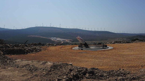
In the Urla-Çeşme peninsula case-study, sampling focussed on three locations west of Urla where archaeological fieldwork by the Urla-Çeşme Peninsula Survey Project had identified small sites of different periods from the presence of terraces, ancient olive trees and ceramic scatters (Koparal et al. Citation2017). The first was an abandoned village c. 2 km north-east of Güvercinlik, which had been inhabited by Anatolian Greeks before the population exchange of 1922–23. A terraced slope to the south of this village extends to a hilltop formerly crowned with the remains of a fort or watchpost in use from the Early Bronze Age, which was destroyed in 2020 by a commercial wind turbine development ().
Figure 3. Site of the early Bronze Age fort or watchpost at Güvercinlik, destroyed in 2020 during installation of a wind turbine. (Photo: Elif Koparal, September 2020)
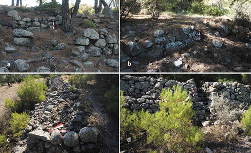
The terraces, standing up to 1.5 m tall and 1.5 m wide, are elaborately built with stone-faced walls incorporating well-built stairs (). Surface finds from pedestrian survey included pottery dated from the late Neolithic to the Byzantine periods. In 2018, three terraces in this system were selected for sampling, including one still cultivated and two abandoned examples. OSL dates obtained from construction deposits suggest the system was created after 1120 ± 130 CE; apparent ages based on profiling samples suggest soils continued to accumulate from the eleventh or twelfth centuries through to the seventeenth-eighteenth centuries CE. A contrasting system of braided terraces was sampled at Granseki, around 1 km west of the modern village at Kadıovacık; OSL dating here suggested construction in the eighth century CE. A third location was sampled on the northern edge of the Barbaros-Çiftlik plain, where a Classical farmstead had been identified through field survey. OSL profiling beneath a field wall on a low earthwork at this site showed the soils had accumulated from the later Middle Ages onwards (1340 ± 140 CE), until the field wall was built in the eighteenth century (Turner et al. Citation2021). Overall the results show that terraces were being built with different morphologies in this fairly small area throughout the Middle Ages and that they continued to be used into the post-Medieval period.
Figure 4. Historic agricultural terraces in the Urla-Çeşme survey area dating to the Middle Ages. a. Barbaros-Çiftlik; b. Granseki; c. Güvercinlik; d. Güvercinlik, showing stone-built stair between terraces. (Scale: 0.5 m. Photos: Elif Koparal, August 2013 (a, c, d); July 2018 (b))
Results from the Cycladic island of Naxos, around 100 km south-west of Çeşme, also provide evidence for medieval terrace construction and use. A single terrace system below the mountain-top Byzantine fortification at Apalirou Kastro was examined in detail. The terraces included abandoned check-dams and braided terraces on a steep hillslope adjacent to an extensive (> 10 ha) settlement of early medieval date (c. 600–1000 CE). Twelve individual terraces were sampled in order to characterize the chronology of the whole system in detail. The results suggested that the system had a long history including subdivisions and reorganizations, but that despite the date of the adjacent settlement, the principal period of use extended from the eleventh to the ninteenth centuries CE (Turner et al. Citation2021).
The evidence from both Naxos and Çeşme showed some terraces of different types were being built and used in the early Middle Ages (c. 600–900 CE), followed by more concerted episodes of construction in the later Medieval period (c. 1000–1600 CE). In both case-study areas, the terrace soils continued to be cultivated into the post-medieval era, indicating that the systems had an active life-span of more than a millennium (Turner et al. Citation2021).The results chime with recent synthesis of palaeoenvironmental research which suggests that although land-use declined following late Antiquity the impact on settlement patterns (Roberts et al. Citation2018) and soil erosion (Roberts et al. Citation2019) in the Aegean and southern Turkey may not have been as extreme as once thought. Direct evidence for the failure of agricultural systems here in the Middle Ages remains elusive, and it seems likely that terraces provided flexible and reliable strategies throughout the period.
Such insights are valuable to archaeologists and help to illustrate scenarios relevant to landscape management, but to share them effectively with other people takes further steps. In both Çeşme and Naxos, the research teams have been involved with transdisciplinary collaborations whose aim was to promote mutual learning between stakeholders, including local planning authorities and the public. For example, in Naxos public dialogue meetings were facilitated to enable local people (n = 270) to document community perspectives on landscape heritage. These highlighted the value of the ‘unofficial’, undesignated heritage of small rural dwellings, threshing floors, terraces and drystone walls (Lekakis and Dragouni Citation2020). In parallel, evenly-balanced panels of representatives from different stakeholders (including experts such as government archaeologists and planners alongside local community members) were convened to address specific issues using the ‘nominal group technique’ (Delbecq, Van De Ven, and Gustafson Citation1975: 108–148; Spencer Citation2010). In this way panel members each contributed a range of insights but agreed on priorities by discussing and voting on the relative desirability of a range of options for future landscape management (Lekakis and Dragouni Citation2019). Though tourism is frequently prioritized in heritage-focussed planning, these discussions underlined the desirability of a wider range of economic strategies for the creation of sustainable future landscapes (Dragouni Citation2020). Meanwhile the Urla-Çeşme Peninsula Survey team worked on a participatory project to implement a mobile phone app which enabled individuals to document autonomously the attributes of landscape they considered most significant during walking and cycling expeditions ().
Figure 5. Participants from a local walking group in Urla-Çeşme experiment with identifying and documenting landscape heritage including historic olive trees and ruined farm buildings using mobile phones. (Photo: Elif Koparal, August 2018)
The exercise – carried out close to the rapidly growing metropolis of Izmir (population c. 4 million) – highlighted the necessity of including not just the people who lived in the immediate study area, but also members of groups who visit this rural landscapes for leisure and recreation. With urbanization and rural depopulation accelerating in many regions, it will be increasingly essential to consider the needs of city-dwellers in planning for socially-just rural landscapes. Landscape archaeology could have an important role to play in such discussions both in terms of explaining past strategies but also in contributing ideas to be debated in the creation of future scenarios ().
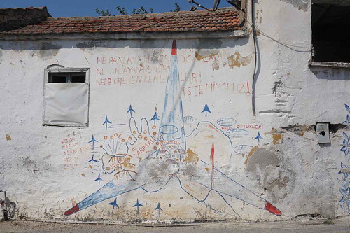
Figure 6. Graffiti in the village of Germiyan, Urla-Çeşme, protesting about environmental destruction. The village is shown at the centre; the text reads ‘We do not want exploding quarries, whizzing wind turbines, and fish farms that pollute our seas’ (top), and ‘Our villages are our places for living’ (left). (Photo and translation by Elif Koparal, August 2018)
Ancient woodland in the UK
Landscape archaeologists could contribute to future woodland creation in substantive ways, potentially leading to real ecological and societal gains. In the UK, the government’s current 25-year environment plan, A Green Future, has committed to a range of environmental measures leading to planned improvements in biodiversity and reduced climate impacts, as well as better health, wellbeing and social benefits; transdisciplinary approaches are therefore recognized as essential (DEFRA Citation2018). A key goal of this strategy is to plant around 180,000 hectares of new woodland by the end of 2042, with the additional commitment to strengthen protection of so-called ‘ancient woodland’. Threats to ancient woodland frequently result in public outcries in the UK (as elsewhere), recently demonstrated by environmental groups’ dismayed response to the new ‘High Speed 2ʹ railway in England, which they claim ‘is the biggest single threat from development to ancient woodland in this country’ (TWT Citation2020, 17).
But ‘ancient woodland’ is not a homogenous category. Even the age required to be considered ‘ancient’ varies across the UK (in England and Wales it usually means woodland which existed before 1600, but in Scotland before 1750). In fact, its value is not really located in its antiquity: the term is used as a shorthand for its ecological complexity, which is often thought to have taken centuries to develop (Rackham Citation1980). The myth that these woodlands are remnants of post-glacial ‘wildwood’ is surprisingly tenacious – and continues to appear even in government policy documents (DEFRA Citation2019, 6) – even though scholars have long argued that the complex character of ‘ancient woodland’ has been shaped by millennia of management, for example as coppice or wood pasture (Peterken Citation1993; Rackham Citation2008; Williamson Citation2016). The ecological consequences of different historic practices – and their cessation over the last 150 years – remain poorly understood, particularly at regional and local scales (Wright and Rotherham Citation2011). For example, whilst the presence of certain plants is often taken as an ‘indicator’ of ancient woodland (Wulf Citation1997; ), relatively recent woods can contain similar types or combinations of plants (Barnes and Williamson Citation2015, 156–7). Some researchers even argue that recently-rewilded woodland can rapidly become ecologically rich (Morel et al. Citation2020). Deeper collaborations between archaeologists, ecologists and others could improve the identification and management of ecologically valuable woodlands and reveal the wider regimes of historic landscape management which contribute to enriching biodiversity (Barnes and Williamson Citation2006; Wright and Rotherham Citation2011; Richer and Gearey Citation2018). This research could also help inform the massive tree-planting schemes of the decades to come by illuminating those factors which have allowed diverse and resilient woodlands to flourish.
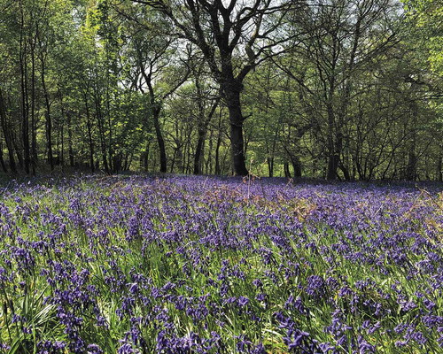
Figure 7. Historic woodland with bluebells (Hyacinthoides non-scripta) on the banks of the Delf Burn, Northumberland, UK. (Photo: Grace Turner, May 2019)
An even greater challenge than finding the most ecologically sustainable strategies could be winning public support for the associated landscape change. The narrative of decline from an all-encompassing ‘wildwood’ in the mists of prehistory to a meagre 3% remnant (or less) in the modern era has reinforced a sense of inevitable loss from a rich past towards an impoverished future, where change and development are necessarily negative forces. By contrast, research in landscape archaeology shows that things have changed frequently in the past and could be used to illustrate scenarios which emphasize the possibility of positive change in the future (Wollenberg, Edmunds, and Buck Citation2000; Kujala et al. Citation2013; Elsawah et al. Citation2020). By working together with practitioners in ecology, forestry, farming, rural economy and planning, knowledge from landscape archaeology could help win public support for new and sustainable strategies for managing and expanding existing woodlands, and for promoting the successful creation of new ones.
Conclusions
Landscape archaeologists know the past is over: the discipline’s principal drive, after all, is to understand how people inhabited past landscapes from material remains. But recognition that change is unavoidable means landscape archaeology can play an important future-facing role. Its scope is not just the discovery and conservation of things which are lost or disappearing, but potentially also to use archaeological knowledge to inform more sustainable living in the future.
In this article, the future-facing potential of landscape archaeology has been considered through three case studies that illustrate the contributions the discipline can make to landscape sustainability. Recent landscape research in China has highlighted the drawbacks of relying on historical narratives to interpret the evolution of land-use. Deconstructing the landscapes of Ming China’s desert frontier at Jiayuguan offers potential for a greater understanding of small-scale innovations in land management, recognizing groups who do not fit into the traditional historical narrative and questioning existing constructs built around military- and monument-focused story of the Great Wall. In the Aegean, histories of land management and environmental impact have been figuratively and literally deconstructed through transdisciplinary research into terrace development and use, resulting in new frameworks for landscape development and the long-term investments these systems represent. This new knowledge has informed community-oriented collaboration focused on moving goals for land-use and tourism towards more socially just, sustainable practices. The development of ancient woodlands of the UK is shrouded in myths and misconceptions that are ultimately counterproductive for sustainability: dispelling these through cooperative research focussed on historical development, management and resilience can lead to better strategies for future growth.
The re-orientation and re-purposing of archaeological knowledge is one of the changes archaeologists can make themselves, but to put that knowledge to work most effectively they will also have to embrace more transdisciplinary working. The potential result could be that landscape archaeologists contribute more fully to creating better futures, not only by identifying effective and ecologically-beneficial land-use strategies, but also by presenting new stories which enable stakeholders to see beyond the political and ideological straightjackets of the past.
Acknowledgments
Survey and dating of terraces on the Çeşme peninsula was supported by the British Academy through a Newton Advanced Fellowship awarded to EK, and community workshops by the Municipality of Izmir. Participatory workshops on Naxos were funded by the UK Arts and Humanities Research Council (AH/P014453/1), Newcastle University and the European Commission (H2020 657050), which also supported development of the Rescaper Tracker mobile app. Ongoing field research is part of the TerraSAgE project (funded by UKRI-AHRC, AH/T000104/1). An exploratory visit to Jiayuguan was supported by the Wall-to-Wall initiative and the Chinese Academy of Cultural Heritage. ST is grateful to Graham Fairclough and Phil Kempson for valuable comments and discussions on this theme.
Disclosure statement
No potential conflict of interest was reported by the author(s).
Additional information
Funding
Notes on contributors
Sam Turner
Professor Sam Turner is a landscape archaeologist at Newcastle University, and Director of the university’s McCord Centre for Landscape.
Tim Kinnaird
Dr Tim Kinnaird is a Research Officer in the School of Environment and Earth Sciences, University of St Andrews. As Director of the CERSA Luminescence Laboratory Kinnaird’s research encompasses a range of geological, environmental and archaeological projects.
Elif Koparal
Dr Elif Koparal is an Associate Professor of Classical Archaeology at Mimar Sinan Fine Arts University, Istanbul whose research focusses on ancient industry, settlement archaeology and landscape archaeology. Koparal is Co-Director of Klazomenai excavations, Director of the Urla-Çeşme Peninsula archaeological survey project, and founder member of the Theoretical Archaeology Group Turkey.
Stelios Lekakis
Dr Stelios Lekakis is a Research Associate in the McCord Centre for Landscape at Newcastle University, and a founder of the Greek Association of Heritage Consultants and the NGO MonuMenta. His research concentrates on cultural heritage, sustainability and commons.
Christopher Sevara
Dr Christopher Sevara is a Research Associate in the McCord Centre for Landscape at Newcastle University, which he joined in 2020 following a PhD and postdoctoral research in landscape archaeology and remote sensing at the University of Vienna.
References
- Acabado, S. 2009. “A Bayesian Approach to Dating Agricultural Terraces: A Case from the Philippines.” Antiquity 83 (321): 801–814. doi:https://doi.org/10.1017/S0003598X00099002.
- Akkemik, Ü., H. Caner, G. Conyers, M. Dillon, N. Karlioğlu, N. Rauh, and L. Theller. 2012. “The Archaeology of Deforestation in South Coastal Turkey.” International Journal of Sustainable Development & World Ecology 19 (5): 395–405. doi:https://doi.org/10.1080/13504509.2012.684363.
- Barley, M. 1961. The English Farmhouse and Cottage. London: Routledge and Kegan Paul.
- Barnes, G., and T. Williamson. 2006. Hedgerow History. Ecology, History and Landscape Character. Oxford: Windgather Press.
- Barnes, G., and T. Williamson. 2015. Rethinking Ancient Woodland. The Archaeology and History of Woods in Norfolk. Hatfield: University of Hertfordshire Press.
- Bertrand, A. 2012. “Water Management in Jingjue Kingdom.” Sino-Platonic Papers 223: 1–81.
- Bevan, A., J. Conolly, S. Colledge, C. Frederick, C. Palmer, R. Siddall, and A. Stellatou. 2013. “The Long-term Ecology of Agricultural Terraces and Enclosed Fields from Antikythera, Greece.” Human Ecology 41: 255–272. doi:https://doi.org/10.1007/s10745-012-9552-x.
- Bürgi, M., A. Hersperger, and N. Schneeberger. 2004. “Driving Forces of Landscape Change – Current and New Directions.” Landscape Ecology 19: 857868.
- Carpenter, S., H. Mooney, J. Agard, D. Capistrano, R. DeFries, S. Díaz, T. Dietz, et al. 2009. “Science for Managing Ecosystem Services: Beyond the Millennium Ecosystem Assessment.” Proceedings of the National Academy of Sciences 106 (5): 1305–1312. doi:https://doi.org/10.1073/pnas.0808772106.
- CoE. 2000. European Landscape Convention. Florence: Council of Europe. https://www.coe.int/en/web/conventions/full-list/-/conventions/treaty/176.
- Colding, J., and S. Barthel. 2019. “Exploring the Social-ecological Systems Discourse 20 Years Later.” Ecology and Society 24 (1): 2. doi:https://doi.org/10.5751/ES-10598-240102.
- Cressey, G. 1958. “Qanats, Karez and Foggaras.” Geographical Review 48 (1): 27–44.
- Crow, J., S. Turner, and A. Vionis. 2011. “Characterizing the Historic Landscapes of Naxos.” Journal of Mediterranean Archaeology 24 (1): 111–137. doi:https://doi.org/10.1558/jmea.v24i1.111
- DEFRA. 2018. A Green Future: Our 25 Year Plan to Improve the Environment. London: Defra. www.gov.uk/government/publications.
- DEFRA. 2019. Keepers of Time. A Statement of Policy for England’s Ancient and Native Woodland. Cambridge/Bristol: Forestry Commission/Defra. https://www.gov.uk/government/publications.
- Delbecq, A., A Van De Ven, and D. Gustafson. 1975. Group Techniques for Program Planning: A Guide to Nominal Groups and Delphi Process. Glenview, IL: Scott Foresman.
- Dessein, J., K. Soini, G. Fairclough, and L. Horlings, eds. 2015. Culture In, for and as Sustainable Development. Conclusions from the COST Action IS1007 Investigating Cultural Sustainability. Jyväskylä: University of Jyväskylä.
- Dragouni, M. 2020. “An Economic Analysis of Heritage as Commons: Reflections on Theory, Methodology and Social Imagery.” In Cultural Heritage in the Realm of the Commons: Conversations on the Case of Greece, edited by S. Lekakis, 45–66. London: Ubiquity. doi:https://doi.org/10.5334/bcj.d.
- Dymitrow, M., and K. Ingelhag. 2020. Anatomy of a 21st-century Sustainability Project: The Untold Stories. Gothenburg: Mistra Urban Futures/Chalmers University of Technology.
- Elsawah, S., S. Hamilton, A. Jakeman, D. Rothman, V. Schweizer, E. Trutnevyte, H. Carlsen, et al. 2020. “Scenario Processes for Socio-environmental Systems Analysis of Futures: A Review of Recent Efforts and a Salient Research Agenda for Supporting Decision Making.” Science of the Total Environment 729: 138393. doi:https://doi.org/10.1016/j.scitotenv.2020.138393.
- Fairclough, G. 2019. “Landscape and Heritage: Ideas from Europe for Culturally Based Solutions in Rural Environments.” Journal of Environmental Planning and Management 62 (7): 1149–1165. doi:https://doi.org/10.1080/09640568.2018.1476026.
- Fairclough, G., H. Baas, B. Bele, N. Dabaut, K.A. Hovstad, G. Jerpasen, K. Larsen, et al. 2020. “The CHeriScape Project, 2014–2016: Key Messages from CHeriScape – Cultural Solutions for Cultural Problems.” Journal of European Landscapes 1: 31–36. doi:https://doi.org/10.5117/JEL.2020.1.47037.
- FAO. 2018. Globally Important Agricultural Heritage Systems. Rome: Food and Agriculture Organization of the United Nations. http://www.fao.org/3/i9187en/I9187EN.pdf.
- Ferro-Vázquez, C., J. Kaal, F. Santos Arévalo, and F. Criado Boado. 2019. “Molecular Fingerprinting of 14C Dated Soil Organic Matter Fractions from Archaeological Settings in NW Spain.” Radiocarbon 61 (1): 101–130.
- Fisher, C. 2020. “Archaeology for Sustainable Agriculture.” Journal of Archaeological Research 28: 393–441. doi:https://doi.org/10.1007/s10814-019-09138-5.
- Forbes, H. 2007. Meaning and Identity in a Greek Landscape. Cambridge: Cambridge University Press.
- Forster, A., G. Medero, T. Morton, and A. Buckman. 2008. “Traditional Cob Wall: Response to Flooding.” Structural Survey 26 (4): 302–321. doi:https://doi.org/10.1108/02630800810906557.
- Foxhall, L., M. Jones, and H. Forbes. 2007. “Human Ecology and the Classical Landscape: Greek and Roman Worlds.” In Classical Archaeology, edited by S. Alcock and R. Osborne, 91–117. Oxford: Blackwell.
- Guttman-Bond, E. 2010. “Sustainability Out of the Past: How Archaeology Can Save the Planet.” World Archaeology 42 (3): 355–366.
- Guttman-Bond, E. 2014. “Productive Landscapes: A Global Perspective on Sustainable Agriculture.” Landscapes 15 (1): 59–76. doi:https://doi.org/10.1179/1466203514Z.00000000024.
- Guttman-Bond, E. 2019. Reinventing Sustainability. How Archaeology Can Save the Planet. Oxford: Oxbow.
- Håkansson, N., and M. Widgren, eds. 2014. Landesque Capital: The Historical Ecology of Enduring Landscape Modifications. Walnut Creek: Left Coast Press.
- Hamilakis, Y. 2007. The Nation and Its Ruins. Antiquity, Archaeology and National Imagination in Greece. Oxford: Oxford University Press.
- Harfouche, R. 2007. Histoire des Paysages Méditerranéens Terrassés:Aménagements et Agriculture (British Archaeological Reports International Series 1634). Oxford: Archaeopress.
- HLPE 2019. Agroecological and other innovative approaches for sustainable agriculture and food systems that enhance food security and nutrition. A report by the High Level Panel of Experts on Food Security and Nutrition of the Committee on World Food Security. Rome. http://www.fao.org/3/ca5602en/ca5602en.pdf
- Høisæter, T.L. 2017. “Migrants or Monks. The Problems of a Migration Scenario in First to Fourth Century Caḍ́ota by the Niya River.” Distant Worlds Journal 3: 81–93. doi:https://doi.org/10.11588/dwj.2017.3.41876.
- ICOMOS. 2019. The Future of Our Pasts: Engaging Cultural Heritage in Climate Action. Paris: ICOMOS.
- Isendahl, C., and D. Stump. 2019. “Conclusion: Anthropocentric Historical Ecology, Applied Archaeology, and the Future of a Usable Past.” In The Oxford Handbook of Historical Ecology and Applied Archaeology, edited by C. Isendahl and D. Stump. Oxford: Oxford University Press. doi:https://doi.org/10.1093/oxfordhb/9780199672691.013.37.
- Jarvie, S., and J.-C. Svenning. 2018. “Using Species Distribution Modelling to Determine Opportunities for Trophic Rewilding under Future Scenarios of Climate Change.” Philosophical Transactions of the Royal Society B 373: 20170446. doi:https://doi.org/10.1098/rstb.2017.0446.
- Jepson, P., and C. Blythe. 2020. Rewilding. The Radical New Science of Ecological Recovery. London: Icon.
- Kinnaird, T., J. Bolòs, A. Turner, and S. Turner. 2017. “Optically-stimulated Luminescence Profiling and Dating of Historic Agricultural Terraces in Catalonia (Spain).” Journal of Archaeological Science 78: 66–77. doi:https://doi.org/10.1016/j.jas.2016.11.003.
- Kolovos, E., and A. Vionis. 2019. “Ottoman Archaeology in Greece: A New Research Field.” Archaeological Reports 65: 145–156. doi:https://doi.org/10.1017/S0570608419000085.
- Koparal, E., Y.E. Ersoy, A. Massa, and V. Demirciler. 2017. “Sampling the Ionian Landscapes: An Overview of Archaeological Surveys at Clazomenaean and Teian Chorai.” In Archaeology of Anatolia Vol. II, edited by S. Steadman and G. McMahon, 400–425. Newcastle: Cambridge Scholars.
- Kristensen, L., and J. Primdahl. 2020. “Landscape Strategy Making as a Pathway to Policy Integration and Involvement of Stakeholders: Examples from a Danish Action Research Programme.” Journal of Environmental Planning and Management 63 (6): 111–1131. doi:https://doi.org/10.1080/09640568.2019.1636531.
- Kujala, H., A. Moilanen, M.B. Araújo, and M. Cabeza. 2013. “Conservation Planning with Uncertain Climate Change Projections.” PLoS ONE 8 (2): e53315. doi:https://doi.org/10.1371/journal.pone.0053315.
- Latocha, A. 2015. “Past Human Activities Recorded in the Landscape: A Case Study from the Glenveagh National Park, Ireland.” Landscape Research 40 (3): 338–358. doi:https://doi.org/10.1080/01426397.2013.829807.
- Latocha, A., K. Reczyńska, T. Gradowski, and K. Świerkosz. 2019. “Landscape Memory in Abandoned Areas—physical and Ecological Perspectives (Central European Mountains Case Study).” Landscape Research 44 (5): 600–613. doi:https://doi.org/10.1080/01426397.2018.1493446.
- Lekakis, S. 2020. “A Political Economy of Heritage and the Commons: A First Sketch Focusing on Greece.” In Cultural Heritage in the Realm of the Commons: Conversations on the Case of Greece, edited by S. Lekakis, 17–44. London: Ubiquity. doi:https://doi.org/10.5334/bcj.c.
- Lekakis, S., and M. Dragouni. 2019. “Από τα μνημεία στα τοπία. Η αγροτική κληρονομιά της Νάξου ως πολιτιστική κληρονομιά «υπό δημιουργία.” Naxiaka 8: 243–254.
- Lekakis, S., and M. Dragouni. 2020. “Heritage in the Making: Rural Heritage and Its Mnemeiosis on Naxos Island, Greece.” Journal of Rural Studies 77: 84–92. doi:https://doi.org/10.1016/j.jrurstud.2020.04.021.
- Lewis, C. 2017. “Evidencing the Impact of Widening Participation Access Programmes for Under-16s: Assessment within the Higher Education Field Academy.” Widening Participation and Lifelong Learning 19 (2): 87–112. doi:https://doi.org/10.5456/WPLL.19.2.87.
- Li, Y., M. Storozum, X. Wang, and W. Guo. 2017. “Early Irrigation and Agropastoralism at Mohuchahangoukou (MGK), Xinjiang, China.” Archaeological Research in Asia 12: 23–32. doi:https://doi.org/10.1016/j.ara.2017.09.005.
- Lu, C., W. Li, M. Pang, B. Xue, and H. Miao. 2018. “Quantifying the Economy-environment Interactions in Tourism: Case of Gansu Province, China.” Sustainability 10: 711.
- Luo, L., X. Wang, J. Liu, H. Guo, R. Lasaponara, W. Ji, and C. Liu. 2017. “Uncovering the Ancient Canal-based Tuntian Agricultural Landscape at China’s Northwestern Frontiers.” Journal of Cultural Heritage 23 (Supplement): 79–88. doi:https://doi.org/10.1016/j.culher.2016.04.013.
- Lyons, S.K., K. Amatangelo, A. Behrensmeyer, A. Bercovici, J. Blois, M. Davis, W. DiMichele, et al. 2016. “Holocene Shifts in the Assembly of Plant and Animal Communities Implicate Human Impacts.” Nature 529: 80–83. doi:https://doi.org/10.1038/nature16447.
- Ma, C., F. Wang, Q. Cao, X. Xia, S. Li, and X. Li. 2008. “Climate and Environment Reconstruction during the Medieval Warm Period in Lop Nur of Xinjiang, China.” Chinese Science Bulletin 53: 3016. doi:https://doi.org/10.1007/s11434-008-0366-6.
- Mächtle, B., S. Hecht, N. Manke, B. Kromer, S. Lindauer, C-S. Li, Y. Li, X. Wang, and O. Bubenzer. 2019. “The Age and Origin of Karez Systems of Silk Road Oases around Turpan, Xinjiang, P.R. Of China.” In Socio-Environmental Dynamics along the Historical Silk Road, edited by L. Yang, H.-R. Bork, X. Fang, and S Mischke, 45–66. Cham: Springer.
- Meskell, L. 2018. A Future in Ruins. UNESCO, World Heritage, and the Dream of Peace. Oxford: Oxford University Press.
- Mischke, S., C. Zhang, C. Liu, J. Zhang, Z. Lai, and H. Long. 2019. “Landscape Response to Climate and Human Impact in Western China during the Han Dynasty.” In Socio-Environmental Dynamics along the Historical Silk Road, edited by L. Yang, H.-R. Bork, X. Fang, and S. Mischke, 45–66. Cham: Springer.
- Monahan, J., and J. Powell. 2011. “An Embodied Carbon and Energy Analysis of Modern Methods of Construction in Housing: A Case Study Using a Lifecycle Assessment Framework.” Energy and Buildings 43 (1): 179–188. doi:https://doi.org/10.1016/j.enbuild.2010.09.005.
- Moore, T., V. Guichard, and J.A. Sanchis. 2020. “The Place of Archaeology in Integrated Cultural Landscape Management. A Case Study Comparing Landscapes with Iron Age Oppida in England, France and Spain.” Journal of European Landscapes 1: 9–28. doi:https://doi.org/10.5117/JEL.2020.1.47039.
- Morel, L., L. Barbe, V. Jung, B. Clément, A. Schnitzler, and F. Ysnel. 2020. “Passive Rewilding May (Also) Restore Phylogenetically Rich and Functionally Resilient Forest Plant Communities.” Ecological Applications 30: 1. doi:https://doi.org/10.1002/eap.2007.
- Nanavati, W., C. French, K. Lane, O. Huaman Oros, and D. Beresford-Jones. 2016. “Testing Soil Fertility of Prehispanic Terraces at Viejo Sangayaico in the Upper Ica Catchment of South-Central Highland Peru.” Catena 142: 139–52.
- Nilsson Stutz, L. 2018. “A Future for Archaeology: In Defense of an Intellectually Engaged, Collaborative and Confident Archaeology.” Norwegian Archaeological Review 51 (1–2): 48–56. doi:https://doi.org/10.1080/00293652.2018.1544168.
- Orbaşli, A. 2013. “Archaeological Site Management and Local Development.” Conservation and Management of Archaeological Sites 15 (3–4): 237–253. doi:https://doi.org/10.1179/1350503314Z.00000000059.
- Pedroli, B., S. Tagliasacchi, T. van der Sluis, and W. Vos. 2013. Ecologia del paesaggio del Monte di Portofino [Landscape Ecology of the Monte di Portofino]. Wageningen: FERGUSON.
- Pei, Q., Z. Nowak, G. Li, C. Xu, and W.K. Chan. 2019. “The Strange Flight of the Peacock: Farmers’ Atypical Northwesterly Migration from Central China, 200 BC–1400 AD.” Annals of the American Association of Geographers 109 (5): 1583–1596. doi:https://doi.org/10.1080/24694452.2019.1570837.
- Peterken, G. 1993. Woodland Conservation and Management. 2nd ed. London: Chapman and Hall.
- Porat, N., U. Davidovich, Y. Avni, G. Avni, and Y. Gadot. 2018. “Using OSL Measurements to Decipher Soil History in Archaeological Terraces, Judean Highlands, Israel.” Land Degradation and Development 29 (3): 643–650.
- Price, S., and L. Nixon. 2005. “Ancient Greek Agricultural Terraces: Evidence from Texts and Archaeological Survey.” American Journal of Archaeology 109: 665–694.
- Puy, A., A. Balbo, and E. Bebenzer. 2016. “Radiocarbon dating of agrarian terraces by means of buried soils.” Radiocarbon 58: 345–63. doi:https://doi.org/10.1017/RDC.2015.21
- Qin, X., J. Liu, H. Jia, H. Lu, X. Xia, L. Zhou, G. Mu, Q. Xu, and Y. Jiao. 2012. “New Evidence of Agricultural Activity and Environmental Change Associated with the Ancient Loulan Kingdom, China, around 1500 Years Ago.” The Holocene 22 (1): 53–61.
- Rackham, O. 1980. Ancient Woodland, Its History, Vegetation and Uses in England. London: Edward Arnold.
- Rackham, O. 2008. “Ancient Woodlands: Modern Threats.” New Phytologist 80 (3): 571–586. doi:https://doi.org/10.1111/j.1469-8137.2008.02579.x.
- Ren, J., W. Zhou, X. Liu, L. Zhou, J. Guo, Y. Wang, Y. Guan, J. Mao, Y. Huang, and R. Ma. 2020. “Urban Expansion and Growth Boundaries in an Oasis City in an Arid Region: A Case Study of Jiayuguan City, China.” Sustainability 12: 210.
- Richer, S., and B. Gearey. 2018. “From Rackham to REVEALS: Reflections on Palaeoecological Approaches to Woodland and Trees.” Environmental Archaeology 23 (3): 286–297. doi:https://doi.org/10.1080/14614103.2017.1283765.
- Richer, S., D. Stump, and R. Marchant. 2019. “Archaeology Has No Relevance.” Internet Archaeology 53. doi:https://doi.org/10.11141/ia.53.2.
- Richmond, O., J. McEntee, R. Hijmans, and J. Brashares. 2010. “Is the Climate Right for Pleistocene Rewilding? Using Species Distribution Models to Extrapolate Climatic Suitability for Mammals across Continents.” PLoS ONE 5 (9): e12899. doi:https://doi.org/10.1371/journal.pone.0012899.
- Roberts C. N., J. Woodbridge, A. Palmisano, A. Bevan, R. Fyfe, and S. Shennan. 2019. “Mediterranean Landscape Change During the Holocene: Synthesis, Comparison and Regional Trends in Population, Land Cover and Climate.” The Holocene 29 (5): 923–937. doi:https://doi.org/10.1177/0959683619826697
- Roberts, N., S. Allcock, S. Barnett, A. Mather, W. Eastwood, M. Jones, N. Primmer, H. Yiğitbaşıoğlu, and B. Vannière. 2018. “Cause-And-Effect in Mediterranean Erosion: The Role of Humans and Climate Upon Holocene Sediment Flux into a Central Anatolian Lake Catchment.” Geomorphology 331: 36–48.
- Rockman, M., and C. Hritz. 2020. “Expanding Use of Archaeology in Climate Change Response by Changing Its Social Environment.” Proceedings of the National Academy of Sciences 117 (15): 8295–8302. doi:https://doi.org/10.1073/pnas.1914213117.
- Shuttleworth, S. 2018. “Editorial Annex: Key Findings and Recommendations from the HERCULES Research Project, and the Need for a Landscape Approach to Environmental Governance.” Landscape Research 42 (8): 819–830.
- Sinclair, P., S. Barthel, and C. Isendahl. 2019. “Beyond Rhetoric: Towards a Framework for an Applied Historical Ecology of Urban Planning.” In The Oxford Handbook of Historical Ecology and Applied Archaeology, edited by C. Isendahl and D. Stump, 524–539. Oxford: Oxford University Press. doi:https://doi.org/10.1093/oxfordhb/9780199672691.013.34.
- Spencer, D. 2010. “Facilitating Public Participation in Tourism Planning on American Indian Reservations: A Case Study Involving the Nominal Group Technique.” Tourism Management 31 (5): 684–690.
- Stein, A. 1933. “Note on a Map of the Turfan Basin.” The Geographical Journal 82 (3): 236–246.
- Stump, D. 2013. “On Applied Archaeology, Indigenous Knowledge, and the Usable Past.” Current Anthropology 54 (3): 268–298. doi:https://doi.org/10.1086/670330.
- Tree, I. 2018. Wilding. London: Picador.
- Trombert. 2008. “The Karez Concept in Ancient Chinese Sources: Myth or Reality?” T’oung Pao, Second Series 94 (1/3): 115–150.
- Turner, S. 2018. “Historic Landscape Characterisation: An Archaeological Approach to Landscape Heritage.” In Routledge Handbook of Landscape Character Assessment, edited by G. Fairclough, I. Sarlov-Herlin, and C. Swanwick, 37–50. London: Routledge.
- Turner, S., T. Kinnaird, G. Varinlioğlu, T.E. Şerifoğlu, D. Athanassoulis, E. Koparal, V. Demirciler, et al. 2021. “Agricultural Terraces in the Mediterranean: Intensive Construction during the Later Middle Ages Revealed by Landscape Analysis with OSL Profiling and Dating.” Antiquity 95. doi:https://doi.org/10.15184/aqy.2020.187.
- TWT. 2020. What’s the Damage? Why HS2 Will Cost Nature Too Much. Newark: Wildlife Trusts.
- UN. 2019. World Urbanisation Prospects. The 2018 Review. New York: United Nations. https://population.un.org/wup/Publications/Files/WUP2018-Report.pdf.
- UNESCO. 2011. Recommendation on the Historic Urban Landscape, Including a Glossary of Definitions. Paris: UNES. http://unesdoc.unesco.org/images/0021/002150/215084e.pdf#page=52.
- Whitehead, C., S. Eckersley, M. Daugbjerg, and G. Bozoğlu, eds. 2019. Dimensions of Heritage and Memory. Multiple Europes and the Politics of Crisis. London: Routledge.
- Williamson, T. 2016. “Where We are with Wood-pasture: Two Recent Books and the Current State of Research.” Landscapes 17 (1): 82–88. doi:https://doi.org/10.1080/14662035.2016.1169040.
- Wollenberg, E., D. Edmunds, and L. Buck. 2000. “Using Scenarios to Make Decisions about the Future: Anticipatory Learning for the Adaptive Co-management of Community Forests.” Landscape and Urban Planning 47 (1–2): 65–77. doi:https://doi.org/10.1016/S0169-2046(99)00071-7.
- Wright, B., and I. Rotherham. 2011. “Assessing Woodland History and Management Using Vascular Plant Indicators.” Aspects of Applied Biology 108: 105–112.
- Wulf, M. 1997. “Plant Species as Indicators of Ancient Woodland in Northwestern Germany.” Journal of Vegetation Science 8 (5): 635–642.