
ABSTRACT
The rise of water transport technology enabled early modern humans to expand their habitable territory to insular environments. However, apart from intensive discussion for Wallacea, developmental process and regional variation of Palaeolithic seafaring remain unclear. To contribute this issue, the author presents a synthetic model for Palaeolithic seafaring in another region of the western Pacific, the Ryukyu Islands (Ryukyus). Here, some islands were more than 100 km away and invisible beyond the horizon, and one of the world’s strongest ocean currents intervened the seaways. Despite these challenging situations, Palaeolithic sites appeared throughout much of the 1,200 km chain of the islands ~35,000–30,000 years ago. By integrating currently available information from archaeology, skeletal morphology, genetics, palaeogeography, oceanography and our own experimental voyage project, the author discusses probable migration routes, possible watercrafts, preparation and strategy needed for successful maritime migrations, and other issues relevant to deeper understanding of the origins and development of human maritime activities.
Introduction
Marine Isotope State 3 (MIS 3) witnessed an abrupt increase in archaeological sites and skeletal remains of modern human on many offshore islands in Southeast and East Asia. This signals the emergence and development of effective seafaring technology by Homo sapiens in a wide area of western Pacific (Kaifu, Izuho, and Goebel Citation2015; Gaffney Citation2020; here, ‘seafaring’ denotes more adept, ambitious maritime activities than ‘seagoing’ as defined by Broodbank Citation2006). There is a growing consensus among specialists that the initial colonization of the Sahul by 47,000 years ago (or earlier) was achieved by deliberate seafarers rather than accidental drifters. Although not all researchers agree (Anderson Citation2017), there are a series of indirect but compelling evidence supporting this view: the need of repeated sea-crossings (O’Connell J, Allen, and Hawkes Citation2010; O’Connor Citation2010), a more or less large number of immigrants needed to establish a viable population (Bradshaw et al. Citation2019; cf. Ihara et al. Citation2020) and archaeologically demonstrated advanced maritime adaptation such as pelagic fishing and fishhooks (O’Connor, Ono, and Clarkson Citation2011). Furthermore, a recent computer simulation concluded that accidental drifting does not explain the Pleistocene peopling of Sahul (Bird et al. Citation2019), although this study relies on the modern oceanographic data to reconstruct the past.
However, past studies of Palaeolithic maritime transports in the western Pacific have heavily focused on Wallacea (and Melanesia) to elucidate the initial colonization of the Sahul. Moreover, research attentions have been centered on the water routes take by the Pleistocene maritime migrants (Birdsell Citation1977; Kealy, Louys, and O’Connor Citation2015, Citation2017, Citation2018; Norman et al. Citation2018), and the question if they were accidental drifters or deliberate seafarers as mentioned above. As a result, other questions such as distribution, developmental process and regional variation of Late Pleistocene seafaring in the western Pacific still remain vague. These questions are difficult to answer because the chronology and routes of the maritime migration are often controversial, and no archaeological remains of watercraft have been discovered from the Pleistocene contexts anywhere in the world (McGrail Citation2001). Additionally, the actual challenges and difficulties of prehistoric sea-crossings cannot be understood from theoretical considerations and speculations.
summarizes issues that need to be considered for a holistic understanding of the origins, development and regional variation of Palaeolithic maritime transport and migration. In this paper, by discussing each of these elements, the author developed a regional model of Palaeolithic seafaring in the Ryukyu Islands of Japan. Many of the information introduced in the following discussion have been resulted from our experimental program called ‘Holistic Reenactment Project of Voyages 30,000 Years Ago’, organized by the National Museum of Nature and Science, Tokyo, and the National Museum of Prehistory, Taiwan (https://www.kahaku.go.jp/research/activities/special/koukai/en/).
Table 1. Major issues for understanding Palaeolithic seafaring.
Calibration of conventional ages were conducted with IntCal20 (Reimer et al. Citation2020) and indicated as probability distributions corresponding to two standard deviations (95.4%).
Geographic settings and Late Pleistocene oceanic condition in the Ryukyus
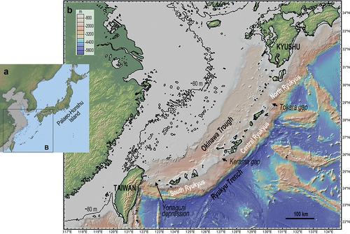
The Ryukyu Islands (also called the Ryukyu Arc or the Ryukyus) consist of ~100 islands distributed as a 1200 km arc between Taiwan and Kyushu (). They are bordered by the Okinawa Trough in the northwest and by the Ryukyu Trench in the southeast. The subduction of the Philippine Sea Plate under the Eurasian Plate at the Ryukyu Trench caused spreading of the Okinawa Trough as a back-arc basin and upheaval of the Ryukyus. Three major regions, North, Central and South Ryukyus are separated by the Tokara Gap and the Kerama Gap, which are ~1,000 m deep and constitute major biogeographic boundaries of the region (Watase and Hachisuka Lines, respectively).
Figure 1. Topography map of the Japanese Archipelago (A) and Ryukyu Islands (B) with the estimated coastlines 35,000–32,000 years ago (figure created using the GeoMapApp 3.6.10 software: https://www.geomapapp.org).
Despite the tectonics, volcanism and sea-level fluctuations during the Late Pleistocene, topography of the Ryukyus has remained largely unchanged partly because of the generally steep coastlines. A long-term isolation of these islands is evident from its fauna. For example, the extant fauna on the Ryukyus are endemic and lack major mammalian taxa such as monkeys and bears, which are common in both Japan's main islands and Taiwan (except for the northernmost islands of Ryukyus which had been connected with Kyushu during the Last Glacial Maximum (LGM)) (Kaifu et al. Citation2015); There were extinct, diminutive deer species on islands of Central and South Ryukyus until the Late Pleistocene, which suggest the ‘island rule’ having acted on these animals (Otsuka and Takahashi Citation2000; van der Geer et al. Citation2011).
The global sea-level 35,000–32,000 years ago is estimated to have been 65–80 m lower than today (Lambeck et al. Citation2014; Yokoyama, Purcell, and Ishiwa Citation2019). illustrates approximate geography of the time, by lowering the sea-level 80 m using the modern seafloor topography. Most islands of the Ryukyus preserve marine terraces that are considered to have been formed in the Last Interglacial Period (Ota and Omura Citation1992; Machida et al. Citation2001). With reference to the elevations of these terraces and supposing constant tectonic movements, the amounts of uplift of the Ryukyu Islands during the last 30,000 years are estimated to be 3–18 m (Kaifu et al. Citation2015). Therefore, the islands in the Ryukyu Arc may have been slightly smaller than illustrated in .
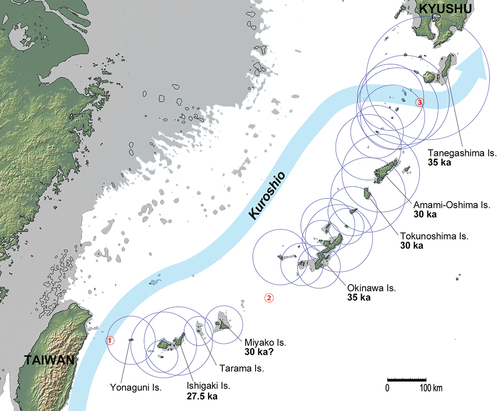
Figure 2. Geography of the Ryukyus 35,000–32,000 years ago reconstructed by lowering the sea-level 80m. The maximum visibilities of major islands from the sea surface during that period are shown by the circles (see Kaifu et al. Citation2020 for method). The oldest known calibrated ages of archaeological sites on six islands are indicated by the bold numerals. The MIS 3/2 flow path of the Kuroshio, which is similar to that in the present-day, is indicated by the thick blue line following Yang et al. (Citation2022). The circled red numbers indicate three major straits that are difficult to cross. Map created using the GeoMapApp 3.6.10 software based on the Global Multi-Resolution Topography synthesis (Ryan et al. Citation2009).
The Kuroshio Current, one of the strongest ocean currents in the world, is the western boundary current of the North Pacific subtropical gyre, which is ultimately controlled by the wind stress curl from the atmospheric circulation. This current originates off the Luzon coast and flows poleward to develop into a fast (0.4–2.0 m/s), thick (<1000 m) and wide (<100 km) stream along the east coast of Taiwan (Andres et al. Citation2015). Off northeastern Taiwan, the Kuroshio flows through the Yonaguni Depression and enters the East China Sea, bumps into the shelf-break of the East China Sea and flows along it before turning eastward to exit to the Pacific through the Tokara Strait ().
Earlier claims that the Kuroshio did not enter the East China Sea, or it did but exited from the Kerama Gap during the last glacial period have been dismissed by succeeding studies. The continuing influx of the Kuroshio into the East China Sea through the Yonaguni Depression, and its outflow from the Tokara Strait are evident from the deep bathymetric features that constrain its present flow path (), and are supported from a number of studies on sediment cores and computer simulation modelling (e.g. Kawahata and Ohshima Citation2004; Ijiri et al. Citation2005; Kubota et al. Citation2017; Vogt-Vincent and Mitarai Citation2020; Yang et al. Citation2022). Temporal variation in the intensity of the Kuroshio during the Last Glacial Period remains controversial, however. While some studies concluded slightly reduced transport during the Last Glacial Maximum (Vogt-Vincent and Mitarai Citation2020), others suggested elevated surface velocity and volume transport of the Kuroshio in the East China Sea (Yang et al. Citation2022; Kubota et al. Citation2017). In summary, the path of the Kuroshio remained essentially unchanged around the Ryukyus during the past more than 100,000 years. However, its intensity may or may not have been different from the present condition.
Therefore, major obstacles for the Palaeolithic maritime migrants in the Ryulyus must have been the need of repeated sea-crossing, generally distant and small target islands, and the strong ocean current. indicates that the target island was invisible from the coast of the departing island at the two longest straits: Taiwan−Yonaguni Island (①) and Miyako−Okinawa Islands (②), where the shortest distances were ~105 and ~220 km, respectively. A notable fact is that the target island was physically invisible even from the mountains of the departing island at the latter strait, and people had to traverse the Kuroshio in the former. At another short strait between Tarama and Miyako Islands, the target was also invisible. The sea of the volcanic front of Tokara (③) was another major hurdle because of the counter flow of the Kuroshio as well as the cliffy coast lines of these active volcanic islands.
Migration history and routes in the Pleistocene Ryukyus
MIS 3/2 sites are distributed in the North, Central and South Ryukyus as illustrated in and summarized in . Based on the findings from these sites, the initial migration to the islands of Ryukyu can be inferred as below.
Table 2. Major Palaeolithic sites of the Ryukyus.
The sites in North Ryukyus (Tanegashima Island) are securely dated to ~35 ka, as described in . Its lithic assemblage shares several components with those from the Early Upper Palaeolithic contexts in Kyushu (38−30 ka: e.g. edge-ground axe, trapezoid, denticulate and some types of pebble tools), suggesting its northern origin (Nakamura Citation2005; Miyata Citation2011). The presence of MIS 3 hunting pitfalls is another shared feature with the mainland Japan (Sato Citation2015). Tanegashima had been connected with Kyushu at the LGM due to the relatively shallow strait between them (105 m depth), but they were probably ~20 km apart from each other during the MIS 3 when people first appeared there.
The lithic assemblages from Central Ryukyus are still poor and have not been analysed in sufficient detail (Yamasaki Citation2014). Although some researchers pay attention to amorphous flakes from Amami-Oshima and Tokunoshima Islands and suggest their southern origins (Kato Citation1996; Oda Citation1999), other specialists claim their affinities with lithics from mainland Japan (Sato Citation2009). On the other hand, the artifacts from Sakitari Cave, Okinawa Island, lack formalized stone tools known from Kyushu, but include rich shell artifacts (scrapers, beads and fishhooks) which are unknown from mainland Japan (Fujita et al. Citation2016). Notably, a 23 ka circular rotating fishhook made from the Tectus (Trochus) shell is strikingly similar to those reported from the terminal Pleistocene of Wallacea (O’Connor et al. Citation2017). In cranial and mandibular morphology, the ~21 ka human skeletal remains from Minatogawa, Okinawa Island, display similar characteristics to the terminal Pleistocene/early Holocene populations in Southeast Asia than to those from northern China and the Holocene Jomon people from mainland Japan (Baba, Narasaki, and Ohyama Citation1998; Kaifu et al. Citation2011; see also Suwa et al. Citation2011b; Saso, Matsukawa, and Suwa Citation2011), suggesting their southern origin via Taiwan.
Human skeletal remains from the Shiraho-Saonetabaru Cave, Ishigaki Island, are potentially informative materials to infer the Late Pleistocene migration routes to South Ryukyus. Morphological analysis of these materials is now underway (Kono et al. Citation2018). A preliminary analysis on their mitochondrial DNA reported that two individuals dated to ~24 and ~25 ka were classified to haplogroups B4e and R, respectively, suggesting their origins from the southern region of the Asian Continent (Shinoda and Adachi Citation2013).
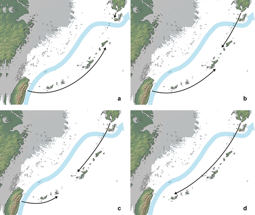
In summary, the available archaeological, skeletal and genetic evidence is still insufficient to draw a firm conclusion about Palaeolithic maritime migration history in the Ryukyus. Still, these collectively indicates the sudden appearance of H. sapiens migrants on these islands both from north and south 35,000 years ago, and the occupation of the entire arc by ~30,000 years ago. illustrates four of the possible colonization hypotheses. We here do not consider migration from the Chinese mainland because its shorelines were too remote (>300 km) and the Kuroshio intervened the seaway (see also Kaifu et al. Citation2020). Based on the above information, the hypothesis A and B currently receive more support than the other scenarios. The hypotheses C and D contradict with the available archaeological, morphological and genetic evidence. In either scenario, the Palaeolithic maritime migrants crossed two or all of the three especially difficult sea areas (①−③ shown in and discussed above).
Figure 3. Four hypotheses explaining the initial maritime migration in the Palaeolithic Ryukyus. The estimated MIS 3/2 flow path of the Kuroshio (the thick blue line) follows Yang et al. (Citation2022).
Frequency of maritime transport
Then, after the initial migration, how often did Palaeolithic people move between these islands? The currently available limited archaeological evidence does not have sufficient resolution to answer this question, but the following points can be drawn.
In the North Ryukyus, there is substantial gap of archaeological records between the earliest occupation levels 35−31 ka and the terminal Pleistocene, when a microblade industry was introduced from Kyushu (Miyata Citation2011), probably via a land bridge existed then. There is no secure evidence for additional maritime transports in Central and South Ryukyus until the onset of Holocene, when potteries were introduced there (Yamasaki Citation2012, Citation2014). However, the sudden appearance and increase of boar on several different islands around 23,000−20,000 years ago may indicate translocation of this animal by humans (Fujita et al. Citation2014).
Evidence for intentional voyages
In mainland Japan, Honshu and Kyushu had been connected to each other during the Late Pleistocene to form Palaeo-Honshu Island (). The dates and distribution of the Early Upper Palaeolithic sites on this large island demonstrate that the earliest sea-crossing occurred ~38 ka at the strait between the Korean Peninsula and Kyushu (Korea/Tsushima Strait) (Izuho and Kaifu Citation2015; Kaifu, Izuho, and Goebel Citation2015), and almost simultaneously at Kozushima Island off Izu Peninsula (Ikeya Citation2015). About 30 ka, some new types of stone artifacts were introduced from the Korean Peninsula to Kyushu (Morisaki Citation2015), and the trapezoid complex similar to that in Honshu appeared in Hokkaido (Izuho et al. Citation2018), suggesting maritime travels at Korea/Tsushima Strait and Tsugaru Strait, respectively. Such an increase of sea-crossing implies deliberate and active maritime travels rather than accidents around Palaeo-Honshu Island. A firm support for this view is the import of obsidian from Kozushima Island to the sites on Honshu as early as 38 ka (Ikeya Citation2015). This small island was approximately 38 km offshore from Honshu at that time.
In the Ryukyus, the entire island arc had been populated during 35–30 ka as stated above. In order to test if accidental drifting can explain the Palaeolithic colonization of the South and Central Ryukyus, Kaifu et al. (Citation2020) examined satellite-tracked buoys drifting in the actual ocean, which are deployed in the Global Drifter Program (formerly known as Surface Velocity Program: SVP) (Lumpkin et al. Citation2013). These authors analysed 138 SVP drifters, which were released in or passed the coastal waters off Taiwan and northeastern Luzon. Among them, 127 were transported north by Kurohio, and only 6 of these (5%) traversed the Kuroshio to reach east side of this strong current, leaving some chance to get close to the islands. Detailed analyses of each of these six buoys revealed that such eastward movements occurred under the influence from a typhoon, moderate to strong northeasterly winter monsoon that makes the sea surface choppy (due to the counteracting current and wind), or when Kuroshio is disturbed by interaction with submesoscale and mesoscale eddies. Although this analysis is based on modern ocean, the local ocean flows have kept largely the same since the Late Pleistocene as reviewed above. Notably, the analysed buoys were released in various seasons during 1989‒2017, reflecting varying oceanic and wind conditions in the actual sea. The demonstrated very low success rate of accidental migration would further decrease when we consider viable population size for successful colonization on a new island, as argued by Ihara et al. (Citation2020) and Kaifu et al. (Citation2020). Not all the sea-crossings in the Palaeolithic Ryukyus may have been resulted from intentional voyages, but the studies reviewed above strongly suggest that the people of the time had the capacity to reach these islands by deliberate voyages.
Watercrafts
To my knowledge, no archaeological remains of watercraft have been discovered from the Pleistocene contexts anywhere in the world. Still, we can narrow the possible Palaeolithic seagoing crafts with reference to the Holocene archaeological and ethnographic records, and in terms of material availability and technological restriction of the time, as well as the voyaging capability of each craft (Howitt-Marshall and Runnels Citation2016; McGrail Citation2001; Anderson Citation2010).
Remains of dugout canoe (logboat) and wooden single-blade paddle are amply reported from the Mesolithic or Neolithic contexts of Japan (Jōmon Period) (Okimatsu and Hattori Citation2015; Kobayashi Citation2015) or other regions of East Asia (Jiang and Liu Citation2005; Lee Citation2014), but evidence of sailing technology and planked boats are lacking (Habu Citation2010; Kaifu et al. Citation2019). Globally, sailing is regarded as a Holocene invention, with the oldest visual representation dating to c. 5000 years ago in Egypt; the earliest East Asian evidence – ideograms from China – dates to c. 3000 years ago (Doran Citation1971; Johnstone Citation1980; McGrail Citation2001; Anderson Citation2010). This allows us to assume that Palaeolithic seagoing crafts were either logboat or other simpler types such as rafts, which were propelled by single-blade paddles rather than by oars or sails.
In our experimental voyage project conducted during 2013–2019, we chose a reed-bundle raft, a bamboo raft and a dugout canoe as candidates for seagoing crafts in the Palaeolithic Ryukyus (Kaifu et al. Citation2019; Kaifu et al. Citation2021). This choice was because their raw materials are available locally, the craft can be constructed using known local MIS 3/2 tools (flaked stones, seashells, etc.), and ethnographic records inform that the craft had been extensively used in the local coastal waters until recently (for the case of bamboo raft). Although there is no local archaeological or ethnographic evidence for reed-bundle rafts, its widespread distribution in the world (Greenhill Citation1976; Hornell Citation1946; Johnstone Citation1980; McGrail Citation2001) coupled with the presence of rice-straw rafts for traditional ritual ceremonies in Japan (Kokubu Citation1992) do not conflict with the hypothesis of its deep history in East Asia.
We did not test a sawn bark boat and a sawn hide boat because of unavailability of suitable materials and their lack in the local ethnographic and historical/archaeological records. The former is ethnographically documented at inland and coastal waters in Australia, South America, Siberia and northern Japan (Hornell Citation1946; Edwards Citation1972; Deguchi Citation1995); the latter is limited to rivers and lakes in low to mid latitudes (India, China, Korea and North and South America: Hornell Citation1946; McGrail Citation2001). Basket boats woven with strips of split bamboo have been used extensively on the rivers and off the coast of Vietnam. However, they travel no farther than approximately 4 km from shore (McGrail Citation2001), and bitumen and other similar materials such as coal tar used for waterproofing Vietnamese basket boats are not naturally available in Taiwan and the Ryukyu Islands.
To examine voyaging capabilities of reed bundle-raft, bamboo raft and dugout canoe, we produced and tested each of them. Because no information is available for the actual designs of the local Palaeolithic watercrafts, our goal in this project was to know the maximum performance of each type of the crafts within limitation of the time and local context.
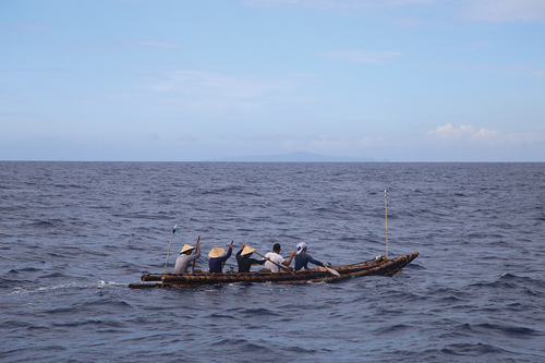
We tested the reed-bundle raft model during 2014–2016 at Yonaguni Island, using the best locally available reed, Typha domingensis Pers. (southern cattail; Typhaceae), and Flagellaria indica L. (whip vine) to bind the bundles of reeds (Kaifu et al. Citation2021). The latter climbing plant, which is similar to rattan, has been traditionally used for binding purposes by local islanders. After testing a small, medium and a large-sized Typha domingensis rafts with different construction designs, we decided to make the final models for an experimental voyage, with reference to the construction method developed at Lake Titicaca, Peru/Bolivia. The size of the two final rafts (~6 m-long) was determined so that they could support several individuals while not excessively increasing the weight so that they could be easily carried over land. Each of these rafts was paddled by seven relatively experienced paddlers.
We tested the bamboo raft model during 2016–2018 in the sea of Kuroshio at the East Coast of Taiwan (Kaifu et al. Citation2019). We used the bamboo species ‘Ma bamboo’ (Dendrocalamus latiflorus Munro), which had been preferred by the local Amis people to make their traditional rafts for coastal fishing (Liu et al. Citation2005). To make the best possible rafts, we searched for especially thick and high-quality Ma bamboo culms (0.14–0.16 m diameter) across a wide area of Taiwan’s east coast and built two different forms of rafts to evaluate the possible difference in performance. The first raft used 11 thick bamboo culms assembled into a boat shape, and was 10.5 m long and 1 m wide. The second raft used seven thick bamboo culms assembled in a 9 m long and 1 m wide mat-shaped raft that resembles the traditional Amis’ raft. As was the case for the reed-bundle rafts, we designed these rafts so that they can support several men and women but were compact and light enough to be carried by a small group of people. These rafts were paddled by five professional or semi-professional sea kayakers.
Ocean currents and tidal flows vary hour by hour, but these are invisible and difficult to detect on site. Influence of such surface flows could not be properly evaluated in the past voyage experiments (Bednarik Citation1998; Bednarik, Hobman, and Rogers Citation1999; Tichý Citation2016; Tzalas Citation1995). We addressed this problem by introducing a supercomputer-based ocean current simulator known as JCOPE-T (http://www.jamstec.go.jp/jcope/vwp/) (Varlamov et al. Citation2015). Using observation data of sea surface elevation, temperature and salinity coupled with wind, heat and tidal forcing as reference/input data, this system reconstructs and visualizes hourly (not daily mean) ocean current conditions of the selected day with high horizontal resolution (approximately 3 km) and high precision.
Our reed-bundle and bamboo rafts showed excellent stability and buoyancy at sea, but all of them lacked mobility, speed and durability required for long-distance voyages needed to migrate to the islands of Ryukyus. Under the current of ~1 m/s, the Typha rafts were drifted along the ocean flow (), and the two types of bamboo rafts could not cross the Kuroshio with the flowing speed of 1.0–1.5 m/s (). Other problems we experienced include gradual water absorption for the reed-bundle rafts and cracking of the bamboo culms for the bamboo rafts (Kaifu et al. Citation2019; Kaifu et al. Citation2021).
Figure 4. Experiment of reed-bundle rafts in 2016 at Yonaguni Island (Photograph by Yousuke Kaifu).
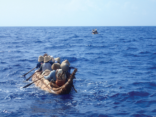
Figure 5. Experiment of a bamboo raft in 2017 on the sea of Kuroshio off east coast of Taiwan (Photograph by Yousuke Kaifu).
Given these results, the author now incline to the idea that more advanced, speedy and durable crafts were used for Palaeolithic maritime migrations in the Ryukyus. The only remaining candidate in this situation may be dugout canoe. This hypothesis implies previously undemonstrated, advanced woodworking technology in the Upper Palaeolithic, but that may be possible given the presence of edge-ground axes/adzes from the Upper Palaeolithic contexts of Japan (Tsutsumi Citation2012) (as well as the Sahul: Clarkson et al. Citation2017). Based on this anticipation, we started to make our dugout canoe in late 2017. This 7.5 m-long boat with a space for 5 paddlers was designed not to exceed the maximum known size of the early Holocene dugout canoe from Japan (Kobayashi Citation2015). Using this boat, we succeeded in traversing Kuroshio in 2019 (Normile Citation2019). A detailed report of that experiment is now in preparation.
Founding population
Some of the sites introduced in demonstrate successful island colonization by the local Palaeolithic modern humans. Almost uninterrupted radiocarbon ages for the archaeological layers in Okinawa Island (Sakitari Cave: ~35‒10 ka) and human remains from Ishigaki Island (Shiraho-saonetabaru Cave: ~27.5‒19 ka) with no noticeable changes in people’s behaviors suggest long-term, continuous human occupation on these islands, unless these were resulted from seamless maritime migrations there. Multiple cultural layers at Tsuchihama-Yaya site on Amami-Oshima Island suggest a similar thing. Then, what were the characteristics of the group who colonized these islands?
The viable initial group size for island colonization depends heavily on fertility and mortality levels. By conducting a series of numerical simulations, Ihara et al. (Citation2020) demonstrated that colonization of an island by 10 or fewer unrelated young men and women can be successful within the range of fertility and mortality levels feasible for recent hunter-gatherers. Although these parameters are impossible to specify for the past populations in each local area, their results give the minimum group size for a successful island colonization.
In our experimental voyage project, all the male and female boat’s crew should be experienced and effective paddlers for a safe travel on the sea with strong and variable ocean flows. If Palaeolithic people did not make lager logboats than currently known from the early Holocene archaeological records, the maximum capacity of each boat did not far exceed five people (see above). This suggests that the Palaeolithic maritime migrants in the Ryukyus traveled with multiple boats paddled mainly by mature males and females, not by families with many small children, at least when crossing distant straits shown in .
Conceiving and planning of safe travels
If we accept that the MIS 3 Ryukyu islanders were qualified seafarers with relatively advanced sea-going crafts (probably dugout canoe) and enough knowledge and skills for safe sea-crossings there, we can advance to discuss possible local scenarios how they planned their travels. In doing so, I assume that the Palaeolithic male and female migrants decided to leave for new islands only when they were confident about a successful migration rather than gabling for unwarranted future. With this assumption, the author makes models for the discovery, preparation and strategy for the two longest water routes that lack visibility of the destination.
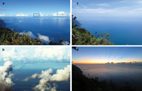
From Taiwan to Yonaguni Island (① in ): My field investigation and information from others revealed that Yonaguni Island is visible from the coastal mountains of northeast Taiwan if conditions permit (). However, this remote, small island is usually not visible behind the clouds or under the daylight that makes the sea and sky indistinguishable ()). The only chances would be (1) in the late afternoon when slanting sunlight from the back illuminates the horizon ()) or (2) just before the dawn when the rising sun behind the island raises its silhouette on the dark water (the author could not encounter this situation in the field due to the clouds: )). Because of this rarity, even the local farmers, the indigenous Taroko people who grew up and are living in the mountains, did not know its visibility. This is probably because they do not frequently come to the seaside of the mountains in early morning or late afternoon. The author speculates that more mobile hunter-gatherers had chances to notice this island in the Late Pleistocene when the sea level was lower than today. However, the island becomes invisible when they get down the mountains, and people had to use heavenly bodies, swells, winds and other natural signatures to navigate for that island.
Figure 6. (a) View from a coastal mountain of Taiwan (Liwushan, Hualien County: about 1200m above sea level) in the late afternoon of 27 August 2017. (b) Yonaguni Island seen 140 km away at the square in (a). (c) The same view as A at noon of 5 August 2016, when horizon is vague under the vertical daylight. (d) The same view as A at dawn on 28 August 2017, when the horizon was masked by clouds. (all photographs by Yousuke kaifu).
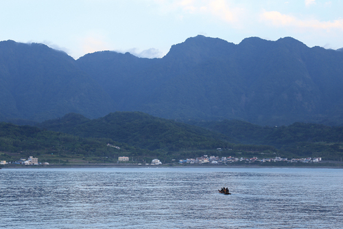
At sea, the migrants had to know about the northward-flowing Kuroshio and choose an appropriate departing point somewhere south to reach Yonaguni Island (see ). This could occur if they frequently went out to sea for fishing. Interestingly, our investigation of the SVP drifters demonstrated that drifted materials off the east coast of Taiwan tend to flow back toward the continent (Kaifu et al. Citation2020). Therefore, drifted fishing boats off the east coast of Taiwan had a high chance to return home safely and people could accumulate knowledge about the offshore current through such experiences. This is particularly likely because Taiwan is easy to find from offshore due to its high elevation up to 3952 m above sea level ().
Figure 7. Coastal mountains of eastern Taiwan, which are reliable landmarks to return home from the sea (photograph at Changping, Taitung County, by Yousuke Kaifu).
The above circumstances could foster the idea and some practical plan for the local Palaeolithic people to migrate to the remote island located at the southwestern edge of the Ryukyus about 35,000 years ago. In our experimental voyage by a dugout canoe, it took more than 45 hours to travel from Taiwan to Yonaguni Island (Normile Citation2019). If the intensity of the Kuroshio has not substantially changed since the Late Pleistocene as discussed above, the MIS 3 migration(s) at this strait must have been one-way travel with no return to recruit additional migrants.
From Miyako to Okinawa Islands (vice versa) (② in ): This is the most mysterious migration path because the target island could not be found physically from the home island and the former became visible only after ~150‒200 km of voyage from the departing island (). If the Palaeolithic Ryukyu islanders crossed this strait as hypothesized in , there may be two scenarios to realize such migration:
After a long-distance, a few days’ survey trip (if we assume the cruising speed of ~1.08 m/s based on our experiment on a dugout canoe) that resulted in the discovery of Okinawa Island, an organized migration was planned by a larger group. This hypothesis connotes that people had been actively searched for new possibilities of living and resource exploitation in a wide area of the ocean.
People believed the existence of invisible landmass for some reasons (e.g. migrating birds, volcanic eruption in North Ryukyus) and decided to organize a migration acknowledging a high risk.
Concluding remarks
Many of the Palaeolithic sites distributed in six different islands of the Ryukyus are well-dated and are useful to reconstruct at least a rough picture of the initial maritime migrations in this region. Other advantages of studying this region include relatively well-studied local palaeogeography and the Late Pleistocene ocean currents, a state-of-the-art ocean current simulator that enables visualization of hourly current conditions with high precision (JCOPE-T), and the relatively rich East Asian Holocene archaeological information that helps to construct a reliable theoretical framework for the preceding Palaeolithic. By integrating such information and being complemented by our own experiments at sea, the following points can be drawn.
MIS 3 Ryukyu islanders were successful voyagers who could disperse the 1200 km-long island chain during ~35,000–30,000 years ago. They made a number of voyages including those confronting strong ocean currents and long-distance travels beyond the sight of land. In crossing such straits, the author hypothesized that people conducted strategic voyages after some preparation as speculated above.
After the initial migration by ~27,500 years ago, there is no secure evidence for sea-crossings until the early Holocene when potteries were introduced to Central and South Ryukyus from somewhere. At the present stage, it is not clear if this reflects the reality or is because of the insufficient archaeological research. There is a suggestion, however, for animal translocation during MIS 2 to Central and South Ryukyus.
Rafts are not reliable crafts to cross the sea of strong currents like Kuroshio. The Palaeolithic maritime migrants in the Ryukyus probably had single-wood dugout canoes (logboats).
The supposed presence of logboats in the East Asian Upper Palaeolithic is not unrealistic, given the occurrence of edge-ground axes from the Early Upper Palaeolithic of mainland Japan (Tsutsumi Citation2012) (but currently not from the Ryukyus and Taiwan). In addition, the evidence of crossing the Tsugaru Strait in northern Japan (41° N) as early as 30,000 years ago (Izuho et al. Citation2018) indicates the existence of seagoing crafts other than bamboo rafts, because thick bamboos are not available in this northern area.
MIS 3 maritime technology was never monotonous or static both spatially and temporally in the western Pacific. In Wallacea, there is evidence for older, extensive maritime migrations by 47,000 years ago or earlier, where at least one main migration path ensured visibility of target islands all through the water route to Sahul (Kealy, Louys, and O’Connor Citation2017). The maritime migrants in the Ryukyus, who began their dispersals more than 10,000 years later, confronted with different oceanic conditions where the target islands are small and sometime invisible, and one of the world’s strongest ocean currents intervenes. Future studies of other regions within or outside the western Pacific would further illuminate the actual variation and early development of humans’ maritime technology and adaptation.
Acknowledgments
The author thanks the participants and supporters of the ‘Holistic Reenactment Project of Voyages 30,000 Years Ago’, and the National Museum of Nature and Science, Tokyo, and the National Museum of Prehistory, Taitung, for their support with this project, and the reviewers for their helpful comments.
Disclosure statement
No potential conflict of interest was reported by the author.
Additional information
Funding
References
- Anderson, A. 2010. “The Origins and Development of Seafaring: Towards a Global Approach.” In The Global Origins and Development of Seafaring, edited by A. Anderson, J. H. Barrett, and K. V. Boyle, 3–16. Cambridge: McDonald Institure for Archaeological Research.
- Anderson, A. 2017. “Ecological Contingency Accounts for Earliest Seagoing in the Western Pacific Ocean.” The Journal of Island and Coastal Archaeology 13 (2): 224–234. doi:10.1080/15564894.2016.1277286.
- Andres, M., S. Jan, T. Sanford, V. Mensah, L. Centurioni, and J. Book. 2015. “Mean Structure and Variability of the Kuroshio from Northeastern Taiwan to Southwestern Japan.” Oceanography 28 (4): 84–95. doi:10.5670/oceanog.2015.84.
- Baba, H., S. Narasaki, and S. Ohyama. 1998. “Minatogawa Hominid Fossils and the Evolution of Late Pleistocene Humans in East Asia.” Anthropological Science 106 (Supplement): 27–45. doi:10.1537/ase.106.Supplement_27.
- Bednarik, R. G. 1998. “An Experiment in Pleistocene Seafaring.” The International Journal of Nautical Archaeology 27 (2): 139–149. doi:10.1111/j.1095-9270.1998.tb00797.x.
- Bednarik, R. G., B. Hobman, and P. Rogers. 1999. “Nale Tasih 2: Journey of a Middle Palaeolithic Raft.” The Internufionul Journul of Nuuticul Archueology 28: 25–33.
- Bird, M. I., S. A. Condie, S. O’Connor, D. O’Grady, C. Reepmeyer, S. Ulm, M. Zega, F. Saltre, and C. J. A. Bradshaw. 2019. “Early Human Settlement of Sahul Was Not an Accident.” Scientific Reports 9 (1): 8220. doi:10.1038/s41598-019-42946-9.
- Birdsell, J. B. 1977. “The Recalibration of a Paradigm for the First Peopling of Greater Australia.” In Sunda and Sahul: Prehistoric Studies in Southeast Asia, Malaysia, and Australia, edited by J. Allen, J. Golson, and R. Jones, 113–167. London: Academic Press.
- Bradshaw, C. J. A., S. Ulm, A. N. Williams, M. I. Bird, R. G. Roberts, Z. Jacobs, F. Laviano, et al. 2019. “Minimum Founding Populations for the First Peopling of Sahul.” Nature Ecology and Evolution 3 (7): 1057–1063. doi:10.1038/s41559-019-0902-6.
- Broodbank, C. 2006. “The Origins and Early Development of Mediterranean Maritime Activity.” Journal of Mediterranean Archaeology 19 (2): 199–230. doi:10.1558/jmea.2006.v19i2.199.
- Clarkson, C., Z. Jacobs, B. Marwick, R. Fullagar, L. Wallis, M. Smith, R. G. Roberts, et al. 2017. “Human Occupation of Northern Australia by 65,000 Years Ago.” Nature 547 (7663): 306–310. doi:10.1038/nature22968.
- Deguchi, A. 1995. Traditional Watercrafts in Japan and Neighboring Regions of Asia- A Cultural Geographic Study. Tokyo: Bunkien Shuppan. (in Japanese).
- Doran, E. J. 1971. “Sailing Raft as a Great Tradition.” In Man across the Sea, edited by C. L. Riley, J. C. L. Kelley, C. W. Pennington, and R. L. Rands, 115–138. Austin: University of Texas Press.
- Edwards, R. 1972. Aboriginal Bark Canoes of the Murray Valley. Adelaide: Rigby for the South Australian Museum.
- Fujita, M., S. Yamasaki, C. Katagiri, I. Oshiro, K. Sano, T. Kurozumi, H. Sugawara, et al. 2016. “Advanced Maritime Adaptation in the Western Pacific Coastal Region Extends Back to 35,000–30,000 Years before Present.” Proceedings of the National Academy of Sciences, USA 113: 11184–11189.
- Fujita, M., S. Yamasaki, H. Sugawara, and M. Eda. 2014. “Body Size Reduction in Wild Boar (Sus Scrofa) from the Late Pleistocene Maehira Fissure Site in Okinawa-jima Island, Japan, with Relevance to Human Arrival.” Quaternary International 339-340: 289–299. doi:10.1016/j.quaint.2014.04.043.
- Gaffney, D. 2020. “Pleistocene Water Crossings and Adaptive Flexibility within the Homo Genus.” Journal of Archaeological Research 29: 255–326.
- Greenhill, B. 1976. Archaeology of the Boat. London: Adam and Charles Black.
- Habu, J. 2010. “Seafaring and the Development of Cultural Complexity in Northeast Asia: Evidence from the Japanese Archipelago.” In The Global Origins and Development of Seafaring, edited by A. Anderson, J. H. Barrett, and K. V. Boyle, 159–170. Cambridge: McDonald Institute for Archaeological Research, University of Cambridge.
- Hornell, J. 1946. Water Transport: Origins and Early Evolution. Cambridge: Cambridge University Press.
- Howitt-Marshall, D., and C. Runnels. 2016. “Middle Pleistocene sea-crossings in the Eastern Mediterranean?” Journal of Anthropological Archaeology 42: 140–153. doi:10.1016/j.jaa.2016.04.005.
- Ihara, Y., K. Ikeya, A. Nobayashi, and Y. Kaifu. 2020. “A Demographic Test of Accidental versus Intentional Island Colonization by Pleistocene Humans.” Journal of Human Evolution 145: 102839. doi:10.1016/j.jhevol.2020.102839.
- Ijiri, A., L. Wang, T. Oba, H. Kawahata, C.-Y. Huang, and C.-Y. Huang. 2005. “Paleoenvironmental Changes in the Northern Area of the East China Sea during the past 42,000 Years.” Palaeogeography, Palaeoclimatology, Palaeoecology 219 (3–4): 239–261. doi:10.1016/j.palaeo.2004.12.028.
- Ikeya, N. 2015. “Maritime Transport of Obsidian in Japan during the Upper Paleolithic.” In Emergence and Diversity of Modern Human Behavior in Paleolithic Asia, edited by Y. Kaifu, M. Izuho, T. Goebel, H. Sato, and A. Ono, 362–375. College Station: Texas A&M University Press.
- Isen Town Board of Education (editor). 2001. Garazo Site. Kagoshima: Isen Town Board of Education. (in Japanese).
- Izuho, M., and Y. Kaifu. 2015. “The Appearance and Characteristics of the Early Upper Paleolithic in the Japanese Archipelago.” In Emergence and Diversity of Modern Human Behavior in Paleolithic Asia, edited by Y. Kaifu, M. Izuho, T. Goebel, H. Sato, and A. Ono, 289–313. College Station: Texas A&M University Press.
- Izuho, M., D. Kunikita, Y. Nakazawa, N. Oda, K. Hiromatsu, and O. Takahashi. 2018. “New AMS Dates from the Shukubai-Kaso Site (Loc. Sankakuyama), Hokkaido (Japan): Refining the Chronology of Small Flake-Based Assemblages during the Early Upper Paleolithic in the Paleo-Sakhalin-Hokkaido-Kuril Peninsula.” PaleoAmerica 4 (2): 134–150. doi:10.1080/20555563.2018.1457392.
- Jiang, L., and L. Liu. 2005. “The Discovery of an 8000-year-old Dugout Canoe at Kuahuqiao in the Lower Yangzi River, China.” Antiquity 87: 46–63.
- Johnstone, P. 1980. The Sea-Craft of Prehistory. Cambridge: Harvard University Press.
- Kagoshima Board of Education (editor). 1988. Tsuchihama-Yaya Site. Kagoshima: Kagoshima Board of Education. (in Japanese).
- Kaifu, Y., and M. Fujita. 2012. “Fossil Record of Early Modern Humans in East Asia.” Quaternary International 248: 2–11. doi:10.1016/j.quaint.2011.02.017.
- Kaifu, Y., M. Fujita, R. T. Kono, and H. Baba. 2011. “Late Pleistocene Modern Human Mandibles from the Minatogawa Fissure Site, Okinawa, Japan: Morphological Affinities and Implications for Modern Human Dispersals in East Asia.” Anthropological Science 119 (2): 137–157. doi:10.1537/ase.090424.
- Kaifu, Y., M. Fujita, M. Yoneda, and S. Yamasaki. 2015. “Pleistocene Seafaring and Colonization of the Ryukyu Islands, Southwestern Japan.” In Emergence and Diversity of Modern Human Behavior in Paleolithic Asia, edited by Y. Kaifu, M. Izuho, T. Goebel, H. Sato, and A. Ono, 345–361. College Station: Texas A&M University Press.
- Kaifu, Y., J. Ishikawa, M. Muramatsu, G. Kokubugata, and A. Goto. 2021. “Establishing the Efficacy of reed-bundle Rafts in the Paleolithic Colonization of the Ryukyu Islands.” The Journal of Island and Coastal Archaeology 1–14. doi:10.1080/15564894.2021.1872120.
- Kaifu, Y., M. Izuho, and T. Goebel. 2015. “Modern Human Dispersal and Behavior in Paleolithic Asia: Summary and Discussion.” In Emergence and Diversity of Modern Human Behavior in Paleolithic Asia, edited by Y. Kaifu, M. Izuho, T. Goebel, H. Sato, and A. Ono, 535–566. College Station: Texas A&M University Press.
- Kaifu, Y., T. H. Kuo, Y. Kubota, and S. Jan. 2020. “Palaeolithic Voyage for Invisible Islands beyond the Horizon.” Scientific Reports 10 (1): 19785. doi:10.1038/s41598-020-76831-7.
- Kaifu, Y., C.-H. Lin, A. Goto, N. Ikeya, M. Yamada, W.-C. Chiang, M. Fujita, et al. 2019. “Palaeolithic Seafaring in East Asia: Testing the Bamboo Raft Hypothesis.” Antiquity 93 (372): 1424–1441. doi:10.15184/aqy.2019.90.
- Kato, S. 1996. “On the Dispersion of Palaeolithic Culture to the Nansei Islands.” Journal of Geography 105 (3): 372–383. doi:10.5026/jgeography.105.3_372.
- Kawahata, H., and H. Ohshima. 2004. “Vegetation and Environmental Record in the Northern East China Sea during the Late Pleistocene.” Global and Planetary Change 41 (3–4): 251–273. doi:10.1016/j.gloplacha.2004.01.011.
- Kealy, S., J. Louys, and S. O’Connor. 2015. “Islands under the Sea: A Review of Early Modern Human Dispersal Routes and Migration Hypotheses through Wallacea.” The Journal of Island and Coastal Archaeology 11 (3): 364–384. doi:10.1080/15564894.2015.1119218.
- Kealy, S., J. Louys, and S. O’Connor. 2017. “Reconstructing Palaeogeography and Inter-island Visibility in the Wallacean Archipelago during the Likely Period of Sahul Colonization, 65-45 000 Years Ago.” Archaeological Prospection 24 (3): 259–272. doi:10.1002/arp.1570.
- Kealy, S., J. Louys, and S. O’Connor. 2018. “Least-cost Pathway Models Indicate Northern Human Dispersal from Sunda to Sahul.” Journal of Human Evolution 125: 59–70. doi:10.1016/j.jhevol.2018.10.003.
- Kobayashi, K. 2015. “Reserch Status of the Jomon Logboats: Current Situation and Prospects”. In History of Islands and Harbor, edited by Chuo University, 3–39. Tokyo: Chuo Universiry Press. (in Japanese).
- Kokubu, N. 1992. Nihon-bunka-no-Koso: Rettou-no-chiritekisoui-to-minzoku-bunka. Tokyo: Daiichi-Shobo. (in Japanese).
- Kono, R. T., K. Okazaki, H. Nakaza, R. Tokumine, C. Katagiri, and N. Doi. 2018. “3D Digital Reconstruction, Preliminary Morphometric Analysis, and Facial Approximation of Shiraho 4 Skull.” Anthropological Science (Japanese Series) 126 (1): 15–36. doi:10.1537/asj.180409. (in Japanese with English summary).
- Kubota, Y., N. Suzuki, K. Kimoto, M. Uchida, T. Itaki, K. Ikehara, R. A. Kim, and K. E. Lee. 2017. “Variation in Subsurface Water Temperature and Its Link to the Kuroshio Current in the Okinawa Trough during the Last 38.5 Kyr.” Quaternary International 452: 1–11. doi:10.1016/j.quaint.2017.06.021.
- Lambeck, K., H. Rouby, A. Purcell, Y. Sun, and M. Sambridge. 2014. “Sea Level and Global Ice Volumes from the Last Glacial Maximum to the Holocene.” Proceedings of the National Academy of Sciences, USA 111: 15296–15303.
- Lee, S. 2014. “On a Logboat Excavated from Bibong-ri Shell Mound Site, South Korea.” Bulletin of the Laboratory of Archaeology, the University of Tokyo 28: 159–186. (in Japanese).
- Liu, C., C. Kao, J.-Z. Lin, and H.-C. Chao. 2005. Bamboo Raft and Fishery Culture of Amis Indigenous People in Eastern Coast of Taiwan. Taitung: Austronesian Community College Association of Taitung County. (in Chinese).
- Lumpkin, R., S. A. Grodsky, L. Centurioni, M.-H. Rio, J. A. Carton, and D. Lee. 2013. “Removing Spurious Low-Frequency Variability in Drifter Velocities.” Journal of Atmospheric and Oceanic Technology 30 (2): 353–360. doi:10.1175/JTECH-D-12-00139.1.
- Machida, H., Y. Ota, T. Kawana, H. Moriwaki, and S. Nagaoka (editors). 2001. Geomorphology of Kyushu and the Ryukyus. Tokyo: University of Tokyo Press.
- Matsu’ura, S., and M. Kondo. 2011. “Relative Chronology of the Minatogawa and the Upper Minatogawa Series of Human Remains from Okinawa Island, Japan.” Anthropological Science 119 (2): 173–182. doi:10.1537/ase.100322.
- McGrail, S. 2001. Boats of the World: From the Stone Age to Medieval Times. Oxford: Oxford University Press.
- Minamitane Board of Education (editor). 2000. Yokomine-C Site. Kagoshima: Minamitane Board of Education. (in Japanese).
- Miyata, E. 2011. “Paleolithic Archaeology of the Satsunan Islands in Southwest Japan.” Palaeolithic Archaeology 75: 71–76. (in Japanese).
- Mizuno, F., J. Gojobori, M. Kumagai, H. Baba, Y. Taniguchi, O. Kondo, M. Matsushita, et al. 2021. “Population Dynamics in the Japanese Archipelago since the Pleistocene Revealed by the Complete Mitochondrial Genome Sequences.” Scientific Reports 11 (1): 12018. doi:10.1038/s41598-021-91357-2.
- Morisaki, K. 2015. “Appearance of Hakuhen-Sentoki (HS Points) and Second Modern Human Migration into Kyushu, Japan.” In Emergence and Diversity of Modern Human Behavior in Paleolithic Asia, edited by Y. Kaifu, M. Izuho, T. Goebel, H. Sato, and A. Ono, 376–388. College Station: Texas A&M University Press.
- Nakamura, M. 2005. “Extraction and Interpretation of the Sandstone Artifacts from Yokomine-C Site.” In Yokomine-C Site, edited by Minamitane Board of Education, 64–71. Kagoshima: Minamitane Board of Education. (in Japanese).
- Nakatane Board of Education (editor). 2002. Tachikiri Site. Kagoshima: Nakatane Board of Education. (in Japanese).
- Norman, K., J. Inglis, C. Clarkson, J. T. Faith, J. Shulmeister, and D. Harris. 2018. “An Early Colonisation Pathway into Northwest Australia 70-60,000 Years Ago.” Quaternary Science Reviews 180: 229–239. doi:10.1016/j.quascirev.2017.11.023.
- Normile, D. 2019. “Update: Explorers Successfully Voyage to Japan in Primitive Boat in Bid to Unlock an Ancient Mystery.” https://www.sciencemag.org/news/2019/07/explorers-voyage-japan-primitive-boat-hopes-unlocking-ancient-mystery
- O’Connell, J, F. J. Allen, and K. Hawkes. 2010. “Pleistocene Sahul and the Origins of Seafaring.” In The Global Origins and Development of Seafaring, edited by A. Anderson, J. H. Barrett, and K. V. Boyle, 57–68. Cambridge: McDonald Institute for Archaeological Research.
- O’Connor, S. 2010. “Pleistocene Migration and Colonization in the Indo-Pacific Regoin.” In The Global Origins and Development of Seafaring, edited by A. Anderson, J. H. Barrett, and K. V. Boyle, 41–55. Cambridge: McDonald Institute for Archaeological Research.
- O’Connor, S.,Mahirta, S. C. Samper Carro, S. Hawkins, S. Kealy, and J. Louys. 2017. “Fishing in Life and Death: Pleistocene fish-hooks from a Burial Context on Alor Island, Indonesia.” Antiquity 91 (360): 1451–1468. doi:10.15184/aqy.2017.186.
- O’Connor, S., R. Ono, and C. Clarkson. 2011. “Pelagic Fishing at 42,000 Years before the Present and the Maritime Skills of Modern Humans.” Science 334 (6059): 1117–1121. doi:10.1126/science.1207703.
- Oda, S. 1999. “Marginal Zone: Late Palaeolithic Cultures around the Ryukyu Islands.” Jinruishi Kenkyu 11: 29–46. (in Japanese).
- Oda, S. 2003. “Paleolithic Artifacts from Yamashita-cho Cave 1.” Nanto Kouko 22: 1–19. (in Japanese).
- Okimatsu, N., and T. Hattori. 2015. “Kaminarishita Site in Chiba Prefecture (Earliest Evidence for the Dugout in Japan).” Koukogaku Journal 671: 29–32. (in Japanese).
- Okinawa Department of Education (editor). 1985. Pinza-abu. Okinawa: Department of Education, Okinawa Prefectural Government. (in Japanese).
- Okinawa Prefectural Archaeological Center (editor). 2017. “Report on Survey Excavation of the Shiraho-Saonetabaru Cave Site.” Okinawa: Okinawa Prefectural Archaeological Center. (in Japanese).
- Ota, Y., and A. Omura. 1992. “Contrasting Styles and Rates of Tectonic Uplift of Coral Reef Terraces in the Ryukyu and Daito Islands, Southwestern Japan.” Quaternary International 15-16: 17–29. doi:10.1016/1040-6182(92)90033-X.
- Otsuka, H., and A. Takahashi. 2000. “Pleistocene Vertebrate Faunas in the Ryukyu Islands: Their Migration and Extinction.” Tropics 10 (1): 25–40. doi:10.3759/tropics.10.25.
- Reimer, P. J., W. E. N. Austin, E. Bard, A. Bayliss, P. G. Blackwell, C. Bronk Ramsey, M. Butzin, et al. 2020. “The IntCal20 Northern Hemisphere Radiocarbon Age Calibration Curve (0–55 Cal kBP).” Radiocarbon 62 (4): 725–757. doi:10.1017/RDC.2020.41.
- Ryan, W. B. F., S. M. Carbotte, J. O. Coplan, S. O’Hara, A. Melkonian, R. Arko, R. A. Weissel, et al. 2009. “Global Multi-Resolution Topography Synthesis.” Geochemistry, Geophysics, Geosystems 10 (3): Q03014. doi:10.1029/2008GC002332.
- Sakura, H. 1981. “Pleistocene Human Bones Found at Pinza-Abu (Goat Cave), Miyako Island: A Short Report.” Bulletin of the National Museum of Nature and Science, Ser. D 7: 1–6.
- Sakura, H. 1988. “Additional Finding of Pleistocene Infant Bones Excavated at Shimojibaru Cave, Kume Island, Okinawa.” Journal of Anthropological Society of Nippon 96: 202.
- Saso, A., S. Matsukawa, and G. Suwa. 2011. “Comparative Analysis of the Glabellar Region Morphology of the Late Pleistocene Minatogawa Crania: A three-dimensional Approach.” Anthropological Science 119 (2): 113–121. doi:10.1537/ase.100726.
- Sato, H. 2009. “A Review of Lower to Upper Palaeolithic Studies in East Asia.” Palaeolithic Kyushu 13: 1–7.
- Sato, H. 2015. “Trap-pit Hunting in Late Pleistocene Japan.” In Emergence and Diversity of Modern Human Behavior in Paleolithic Asia, edited by Y. Kaifu, M. Izuho, T. Goebel, H. Sato, and A. Ono, 389–405. College Station: Texas A&M University Press.
- Shinoda, K., and N. Adachi. 2013. “DNA Analysis of Human Skeletal Remains Excavated from the Shiraho-Saonetabaru Site.” In Shiraho-Saonetabaru Site, edited by Okinawa, Prefectural Archaeological Center, 219–228. Okinawa: Okinawa Prefectural Archaeological Center. (in Japanese).
- Suwa, G., M. Fujita, S. Yamasaki, I. Oshiro, H. Baba, N. Shinzato, T. Kinjo, Y. Kaifu, and S. Matsu’ura. 2011a. “New Insights on the Excavation and Chronological Status of the Late Pleistocene Minatogawa Human Fossils from Okinawa Prefecture.” Anthropological Science (Japanese Series) 119 (2): 125–136. doi:10.1537/asj.110727. (in Japanese with English summary).
- Suwa, G., H. Fukase, R. T. Kono, D. Kubo, and M. Fujita. 2011b. “Mandibular Tooth Root Size in Modern Japanese, Prehistoric Jomon, and Late Pleistocene Minatogawa Human Fossils.” Anthropological Science 119 (2): 159–171. doi:10.1537/ase.110617.
- Suzuki, H., and K. Hanihara, editors. 1982. The Minatogawa Man: The Upper Pleistocene Man from the Island of Okinawa. Tokyo: University Museum, The University of Tokyo.
- Takamiya, H., M. Tamaki, and M. Kin. 1975a. “Artifacts of the Yamashita-cho Cave Site.” Journal of Anthropological Society of Nippon 83 (2): 137–150. doi:10.1537/ase1911.83.137. (in Japanese with English summary).
- Takamiya, H., M. Tamaki, and M. Kin. 1975b. “Excavation Report of the Yamashita-cho Cave Site, Naha-shi, Okinawa.” Journal of Anthropological Society of Nippon 83 (2): 125–130. doi:10.1537/ase1911.83.125. (in Japanese with English summary).
- Tamura, K., and O. Ikeda. 1995. “Kishikawa Site: Report of 3rd and 4th Excavations.” Aoyama Shigaku 14: 1–63.
- Tichý, R. 2016. “The Earliest Maritime Voyaging in the Mediterranean: View from Sea.” Živá Archeologie 18: 26–36.
- Trinkaus, E., and C. B. Ruff. 1996. “Early Modern Human Remains from Eastern Asia: The Yamashita-cho 1 Immature Postcrania.” Journal of Human Evolution 30 (4): 299–314. doi:10.1006/jhev.1996.0025.
- Tsutsumi, T. 2012. “MIS3 edge-ground Axes and the Arrival of the First Homo Sapiens in the Japanese Archipelago.” Quaternary International 248: 70–78. doi:10.1016/j.quaint.2011.01.030.
- Tzalas, H. 1995. “On the Obsidian Trail: With a Papyrus Craft in the Cyclades.” 3rd International Symposium on Ship Construction in Antiquity, Athens. 441–469.
- van der Geer, A. A., G. A. Lyras, J. de Vos, and M. Dermitzakis. 2011. Evolution of Island Mammals: Adaptation and Extinction of Placental Mammals on Islands. The Atrium: Wiley-Blackwell.
- Varlamov, S. M., X. Guo, T. Miyama, K. Ichikawa, T. Waseda, and Y. Miyazawa. 2015. “M 2 Baroclinic Tide Variability Modulated by the Ocean Circulation South of Japan.” Journal of Geophysical Research: Oceans 120 (5): 3681–3710. doi:10.1002/2015JC010739.
- Vogt-Vincent, N. S., and S. Mitarai. 2020. “A Persistent Kuroshio in the Glacial East China Sea and Implications for Coral Paleobiogeography.” Paleoceanography and Paleoclimatology 35 (7): e2020PA003902. doi:10.1029/2020PA003902.
- Yamasaki, S. 2012. “Palaeolithic Ryukyu Islanders and the Northward Migration Hypothesis.” Palaeolithic Kyushu 16: 79–90. (in Japanese).
- Yamasaki, S. 2014. “Recent Archaeological Studies on the Human Fossils and Their Culture from Late Pleistocne to Early Holocene Transition in Ryukyu Archpelago.” Palaeolithic Research 10: 1–9. (in Japanese).
- Yang, H., X. Guo, Y. Miyazawa, S. M. Varlamov, A. Abe-Ouchi, and W.-L. Chan. 2022. “Changes in the Kuroshio Path, Surface Velocity and Transport during the Last 35,000 Years.” Geophysical Research Letters 49 (4): e2021GL097250. doi:10.1029/2021GL097250.
- Yokoyama, Y., A. Purcell, and T. Ishiwa. 2019. “Gauging Quaternary Sea Level Changes through Scientific Ocean Drilling.” Oceanography 32 (1): 64–71. doi:10.5670/oceanog.2019.121.