
ABSTRACT
The occupation of Buang Merabak, a cave located on the island of New Ireland, by 42,000 years ago demonstrates that the colonisation of the Bismarck Archipelago occurred soon after that of Sahul. This provides the opportunity to consider the adaptation of small groups of people to a depauperate island environment. An analysis of a lithic assemblage from Buang Merabak was used to consider how technological organisation reflects changing patterns of site use and subsistence strategies from the late Pleistocene through to the early Holocene. A strategy of small simple flake technology was identified, which would have allowed site occupants flexibility in the face of fluctuating patterns of faunal resource use. During the late Pleistocene, a broad range of local lithic materials were used expediently. Gradual change occurred in the early Holocene to a smaller variety of materials with dominant use of local chert flakes and conservation of specific volcanic materials.
Introduction
Human exploration and colonisation of Sahul (comprising New Guinea, Australia, Tasmania, and the Aru Islands) from Southeast Asia and Wallacea is generally accepted to have occurred by at least 50–48,000 years ago, during periods of glacio-eustatic lower sea levels (Allen and O’Connell Citation2014; Balme and O’Connor Citation2014; Summerhayes and Ford Citation2014; Veth et al. Citation2017). Older dates of 70–60,000 BP have been published for sites in the Philippines (Mijares et al. Citation2010), Laos (Shackelford et al. Citation2018), Sumatra (Westaway et al. Citation2017) and Northern Australia (Clarkson et al. Citation2015, Citation2017). These results derive from uranium series, optically stimulated luminescence (OSL), and thermoluminescence (TL) dating methods, which are still undergoing debates over taphonomic rigour (Allen and O’Connell Citation2014; Allen Citation2017; O’Connell et al. Citation2018).
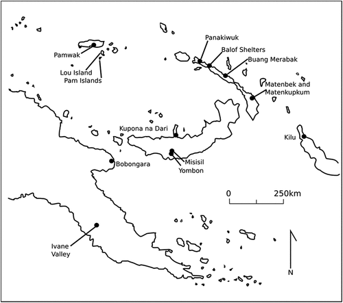
Regardless of the specific timing of the initial colonisation event, one of the significant achievements of the colonisation of Sahul was the ability to undertake deliberate water crossings. Voyaging from Sunda into Sahul, irrespective of whether modern humans followed the northern route into the Bird’s Head Peninsula of New Guinea, or the southern route from Timor/Roti to northwest Australia, required at least five water crossings. Following colonisation of the main Sahul landmass, modern humans completed further water crossings into the Bismarck Archipelago by at least 42,000 years ago, which is the earliest occupation date for the cave site of Buang Merabak (Leavesley et al. Citation2002). Crossing into New Britain and New Ireland would have required sea voyages of at least 50 km from New Guinea to New Britain (Summerhayes and Ford Citation2014). A further 180 km separates New Ireland from Buka (although again shorter routes are possible if island hopping, reducing the longest distance to 60 km) (Summerhayes and Ford Citation2014). The Bismarck Archipelago, together with the Kilu site on Buka Island (Wickler Citation2001), sets the northeastern extent of this large-scale colonisation trajectory of modern humans until the much later Austronesian expansion into Remote Oceania ().
Figure 1. Map of archaeological sites in the Bismarck Archipelago in relation to eastern Papua New Guinea.
Although Sahul was settled by populations with similar origins and hunter-gatherer subsistence practices, recent genetic evidence has pointed to a long-term isolation between Australian and New Guinean populations (Bergström et al. Citation2017; Nagle et al. Citation2017; Tobler et al. Citation2017), and also between mainland Papua New Guinea (PNG) and the Bismarck Archipelago (Choin et al. Citation2021), making room for the development of regional traditions early in Sahul’s history. This is borne out in the lithic technology as, while there are similarities between the initial Pleistocene assemblages, there are also many inter-regional and inter-site variations. For example, although the overarching late Pleistocene to early Holocene lithic technology across Sahul was of cores, flakes, and scrapers (Balme and O’Connor Citation2014; White and O’Connell Citation1982), in some places a variety of large formal tool types are also present, including waisted tools at sites in mainland PNG (Ford Citation2017) and ground edge axes in sites across Northern Australia (Balme and O’Connor Citation2014; Clarkson et al. Citation2017; Ford and Hiscock Citation2021; Hiscock et al. Citation2016).
It is clear that rather than treating Sahul lithic technology as a homogenous entity, variations in assemblages across sites need to be examined against a wide range of local factors. These include raw material availability, the nature of the subsistence economy and local resource structure, levels of mobility and sedentism, as well as potential cultural and social influences to determine how these different factors impacted upon regional expressions of lithic technology.
The Bismarck Archipelago, in particular, is often treated independently of Australia and PNG as the lithic technology here lacks the formal tool types associated with the mainland sites, with the exception of the site of Yombon on New Britain that has a single unifacial ovoid scraper (Pavlides Citation2004). Bismarck technology is therefore generally described as being a simple, ‘amorphous’ (lacking regular retouch patterns) flake technology, with variation explained primarily as reflecting raw material availability and high mobility levels (Allen, Gosden, and White Citation1989; Freslov Citation1989; Pavlides Citation2004; Torrence et al. Citation2004).
The islands of the Bismarck Archipelago are much smaller and have lower biodiversity than the large landmasses of Australia and New Guinea. This is reflected in the faunal record of five sites in New Ireland that have occupation beginning in the late Pleistocene (Matenkupkum, Matenbek, Panakiwuk, Balof Shelters 1 and 2, and Buang Merabak). The earliest of these sites is Buang Merabak, and a model for a changing subsistence strategy based on the faunal remains, including faunal introductions around 20,000 years ago, has been developed by Matthew Leavesley (Citation2004). This model is unique for PNG, as other sites that pre-date 30,000 years ago either lack faunal remains or their faunal assemblages remain unpublished. The lithic assemblage from Buang Merabak therefore offers an excellent opportunity to combine the faunal and lithic knowledge from a site that has a record of periodic occupation of more than 35,000 years, to consider how human technology, resource procurement, subsistence, and mobility interacted in the late Pleistocene through to the early Holocene. This is of importance in understanding adaptation to, and manipulation of, tropical island environments by the first settlers of Near Oceania, which in itself is significant for adding a new dimension on the range of colonisation and subsistence strategies employed by modern humans in their global colonisation of a diverse range of environments. This approach also allows a more holistic view of understanding lithic technology that does not simply derive from raw material availability and that more accurately represents the plethora of human activities resulting in the archaeological record. This study outlines the organisation of the lithic technology employed at Buang Merabak across the late Pleistocene to the early Holocene. It will be discussed in the context of Leavesley’s (Citation2004) model of subsistence strategy and faunal introductions to identify the interaction between resource procurement and use and mobility levels in a tropical island environment.
Late Pleistocene New Ireland
New Ireland is a narrow island in the Bismarck Archipelago, 350 km long by 10–30 km wide, northeast of mainland PNG (). The island is covered by tropical lowland rainforest and montane woodlands, environments that have changed little into the Holocene (Summerhayes et al. Citation2016, 2). The island’s topography is dominated by the steep central Hans Meyer mountain range, up to 2,400 m high in the south, and an uplifted eastern coral coast, reaching 1,480 m above sea level (asl) in central New Ireland (Allen, Gosden, and White Citation1989; Freslov Citation1989; Hohnen Citation1978). While the environmental and geological biodiversity are depauperate compared to mainland PNG, raw lithic material is abundant in both quantity and diversity, exposed along the coast in outcrops, and as cobbles throughout river systems (). Limestone and chert are available in the uplifted central Lelet and Surker Limestone, and volcanic tuff and altered and Quaternary volcanics collectively make up the Jaulu Volcanics in the north, centre, south, and on the nearby small island groups of Tabar, Lihir, Tanga, and Feni (Hohnen Citation1978). Outcrops of gabbro, norite, diorite, trondhjemite, granodiorite, and some porphyritic rhyodacite intrude into these volcanics, termed the Lemau Intrusive Complex.
Figure 2. Stone sources and archaeological sites occupied from the late Pleistocene on New Ireland.
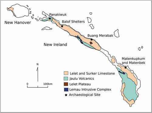
There are five archaeological sites on New Ireland with occupation in the late Pleistocene. These were either identified or re-excavated during the 1980s Lapita Homeland Project (Allen, Gosden, and White Citation1989; Allen and Gosden Citation1996). All of the sites are rock shelters or caves and, except Panakiwuk, are situated within the exposed coral terraces of the Lelet Limestone on the north coast (). Buang Merabak, Matenkupkum, and Matenbek were occupied from 42,000, 40,000, and 20,000 years ago, respectively (Allen, Gosden, and White Citation1989; Leavesley Citation2004; O’Connell, Allen, and Hawkes Citation2010), while Panakiwuk and Balof 2 in the north were occupied much later, around 15,000 years ago (Marshall and Allen Citation1991) and 14,000 years ago, respectively (Downie and White Citation1978; White et al. Citation1991). This collection of sites was continuously occupied since 42,000 years ago, although with periodic use at individual sites, and the most extensive settlement was not until the transition from the Pleistocene to the Holocene (Allen, Gosden, and White Citation1989). The lithic assemblages of Balof 2 and Panakiwuk have been described briefly and only in the initial excavation report (Allen, Gosden, and White Citation1989), while material from Matenkupkum and Matenbek has been analysed in greater detail in a BA Honours dissertation (Freslov Citation1989). While all sites generally show a similar simple flake and core technology, differences between the northern and southern sites has been attributed to differences in raw material availability in northern and southern New Ireland.
Site description
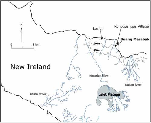
Buang Merabak is situated c 150 m asl near the modern village Konogungus (). The cave has three chambers extending c 30 m back. In 1985, one 0.5 m2 and two 1 m2 excavation squares were excavated to a maximum of 1.65 m deep several metres in from the cave’s entrance by Andree Rosenfeld as part of the Lapita Homeland Project (Rosenfeld Citation1997). In 2000, Matthew Leavesley excavated two further 1 m2 squares to a depth of 2 m in between Rosenfeld’s test pits, with extra material being collected between 2001 and 2002 (Leavesley Citation2004, Citation2005; Leavesley et al. Citation2002; Leavesley and Allen Citation1998; Leavesley and Chappell Citation2004). This work yielded detailed information on the site’s depositional history, sediment structure, and faunal material (Leavesley Citation2004).
Figure 3. Location of Buang Merabak, New Ireland.
Shell midden, animal bones, stone and shell artefacts, and Celtis sp. seeds were recovered from the excavations. Rosenfeld (Citation1997) published a radiocarbon estimate of 31,990 ± 830 BP (ANU6614; shell) for the deepest stratigraphic layer but Leavesley (Citation2004) excavated material at greater depth and radiocarbon dated two shell samples from the base of his Unit 4 to produce a date of at least 42,000 cal BP (ANUA15808 shell: 39,090 ± 550 BP, 43,587–42,093 cal BP 2ơ; ANUA15809 shell: 40,090 ± 550 BP, 42,770–41,584 cal BP 2ơ) (original dates from Leavesley and Chappell Citation2004; radiocarbon calibrations determined by OxCal (ver. 4.4) using Marine20 calibration curve (Heaton et al. Citation2020)). There were four occupation phases at Buang Merabak (Units 1–4) from c.42,000 cal BP to c.1,000 cal BP separated by three hiatus periods. The last phase, Unit 1, was occupied within the context of Lapita colonisation and interaction within Near Oceania.
Previous studies on lithic technology of Buang Merabak
Rosenfeld (Citation1997) briefly analysed the lithic assemblage from the 1985 excavation, concluding that stone use was ‘opportunistic and infrequent’ and that alternative materials such as bamboo may have been favoured. Shell tools have been recognised at Buang Merabak, Panakiwuk, Balof 2, and Matenbek (Leavesley Citation2004, 42; Marshall and Allen Citation1991; White et al. Citation1991). Leavesley and Allen (Citation1998) also analysed the assemblage from Rosenfeld’s (Citation1997) square 2B and described it as ‘technologically uncomplicated’, consisting of small flakes and angular fragments with no bipolar flaking, little retouch, and some usewear, made of a variety of materials, mostly from river cobbles. The non-obsidian lithic assemblage from the 2000 excavations has only been given a cursory description (Henham and Leavesley Citation2004).
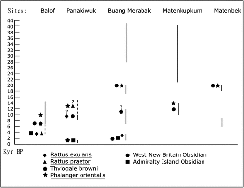
The obsidian assemblage has garnered more attention (Leavesley and Allen Citation1998; Leavesley and Read Citation2011; Summerhayes and Allen Citation1993). Due to the lack of obsidian sources on New Ireland itself, these artefacts reveal instances of raw material transport and inter-island exchange. Small amounts of obsidian from Talasea, West New Britain, were introduced to south New Ireland around 20,000 BP (Summerhayes and Allen Citation1993) (). At Buang Merabak, it is argued that the first obsidian also appears at 20,000 BP and this has been sourced to West New Britain (mostly to Talasea but with one piece from Mopir at this early age) (Leavesley and Read Citation2011).
Figure 4. Timeline of exotic introductions to five New Ireland archaeological sites.
Faunal model for Buang Merabak
Late Pleistocene subsistence practices on New Ireland shifted from an original dominant strategy focused on fruitbat and native fauna hunting, to another around 20,000 years ago, when evidence for purposeful translocation of animals occurs, starting with the introduction of cuscus (Phalanger orientalis) from the mainland of New Guinea at the site of Matenbek (Allen, Gosden, and White Citation1989). Generally, both strategies relied on highly mobile hunting and gathering between different patches (coastal, cave, and forest). Allen, Gosden, and White (Citation1989, 558) describe New Ireland subsistence as a ‘rotational cropping system of exploitation’ opportunistically targeting a wide variety of mammals, reptiles, shellfish, fish, fruits, and nuts. Apart from the translocation of animals, other evidence for change over time is present within the shellfish gathering, with over-exploitation of local shellfish populations demonstrated at Matenbek, Matenkupkum, and Buang Merabak around the start of the Holocene through the reduction of species size, concurrent with an increase in the variety collected (Balean Citation1989).
Buang Merabak itself was a desirable location economically as it was a natural roost for bats, close to coastal beaches and mangroves, and surrounded by lowland rainforest. It has been argued that the site was part of a pattern of high regional mobility as a dense hunting patch for bats (Dobsonia anderseni and to a lesser extent D. praedrix), the remains of which dominate the early faunal record (Units 4 and 3) (Leavesley Citation2004), although cuscus also appears for the first time in Unit 3. A dramatic shift began in Unit 2, 13,280–7,860 cal. BP (original dates of ANU11543 shell and ANU 11540 shell in Leavesley Citation2004, 80) as cuscus became the dominant protein species at Buang Merabak, with some pademelon (Thylogale browni) also introduced. The arrival of cuscus and pademelon, species not endemic to New Ireland, at all five New Ireland archaeological sites within 10,000 years of its first occurrence indicates a conscious transport of these species from mainland PNG to improve protein resources on the island ().
As a result of changes in faunal structure, human mobility around Buang Merabak altered. Leavesley (Citation2004) notes that during early occupation of Buang Merabak, subsistence was focused on the availability of high density bat resources that used the cave as a roost, supplemented by occasional trips to the coast. This practice meant that there were high levels of regional mobility between dense resource patches such as caves and short periods of time at each place to allow the resources to regenerate or return. The arrival of cuscus and its subsequent dominance of the faunal record from 13,000 years ago not only signifies a change in resource procurement strategies, but also resulted in decreased residential mobility as stays at sites were longer term for the hunting of dispersed low density cuscus in the surrounding area. The role of the cave therefore changed to become an occupation node for hunting trips, which is similar to the role of the Balof shelters (White et al. Citation1991). While both the rainforest and marine zones were regularly exploited, the forest environment consistently played a more important role to the early inhabitants of mid-north New Ireland, as their coastal economies fluctuated in response to sea level changes affecting resource productivity and foraging costs (O’Connell, Allen, and Hawkes Citation2010). In light of these changing subsistence strategies and mobility patterns, the question is what affect can be seen on the lithic technology and its overall organisation at Buang Merabak?
Materials and methods
Due to the age of late Pleistocene sites in the Bismarck Archipelago, lithic artefacts are the most common artefact type recovered. Links between lithic technology, subsistence strategies, landscape learning, and mobility are well recognised in lithic studies but lithic assemblages are still too often analysed independently of their environmental and subsistence contexts (Ford Citation2011). Yet, the construction and organisation of lithic technology will fundamentally depend on the particular subsistence strategy employed by the groups using it (Kuhn Citation1994). Different factors such as level or type of mobility, types of tasks required to be undertaken, raw material availability, and exchange networks available will all impact upon how a lithic technology is organised, including the different stages of raw material procurement, manufacture, use, reuse, or recycling and final discard. Each of these stages therefore has the ability to indicate why particular decisions are being made to construct a technology in a particular fashion. A holistic approach, such as the chaine operatoire, which examines the life history of an artefact, is therefore needed to understand the organisation of the technology fully, and is particularly applicable to an ‘amorphous’ assemblage as this type of approach looks beyond formal tool types to include the whole assemblage (debitage, raw material, tools).
Sample and technological analysis
Stone artefacts from spits 9 to 40 (Units 2 to 4) of Leavesley’s (Citation2004) test pit TP1B were selected for analysis. These units date to 42–29k cal BP (Unit 4), 23.5–19k cal BP (Unit 3) and 13–7.8k cal BP (Unit 2). Artefacts from spits 1 to 8 (Unit 1), dating to the Lapita Period of 3,300–1,000 cal BP were excluded. The 15 obsidian artefacts from TP1B were also not included in the technological analysis as this has been described previously (Leavesley and Read Citation2011) and were not available for re-analysis. However, the counts and weights of obsidian in relation to the proportions of raw material use at the site will be described below (). The sample (n = 1,034) was washed, weighed, and analysed in detail at the Archaeology Laboratory, University of Otago, New Zealand. Artefacts were identified to artefact class (flake, broken flake, angular fragment, or core) and their technological attributes recorded such as presence/absence, and proportion, location, and count (where applicable) for cortex, negative flake scars, flaking platforms, flaking directions, usewear, and retouch. Metric data of weight, maximum thickness, length, and width was recorded for each artefact, with the addition of axial length and width for each flake (Holdaway and Stern Citation2004). Macroscopic usewear was identified as any edge damage such as micro-flakes, striations, or gloss, identified with a hand lens (10x). Retouch was categorised as the re-flaking of an artefact for edge rejuvenation or tool production, including the recycling of a flake as a core. The raw material of the stone artefacts were identified by Dr Mike Palin, Department of Geology, University of Otago, New Zealand.
Table 1. Counts of each artefact class in each unit at Buang Merabak.
Table 2. Different raw materials at Buang Merabak by number, total weight and weight proportion to number.
Results
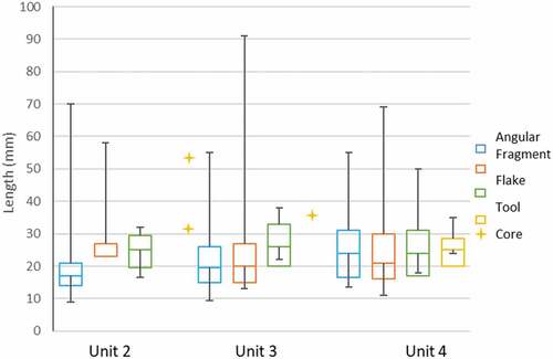
Buang Merabak’s lithic technology is characterised by the production of a large number of small flakes, mostly less than 5 g in weight and 30 mm in length (). The small size of the flakes do not greatly change over time (). The majority of artefacts are unretouched flakes (n = 453) and angular fragments (n = 435) which suggests flake production occurred on site (). Cores only account for 1.2% of the sample (n = 12), mostly from Unit 4. Just under 10% of the total assemblage (108/1034) are tools, here defined as any artefact that has been used, evidenced by macroscopic usewear or retouch.
Figure 5. Weight (g) of artefact classes at Buang Merabak.
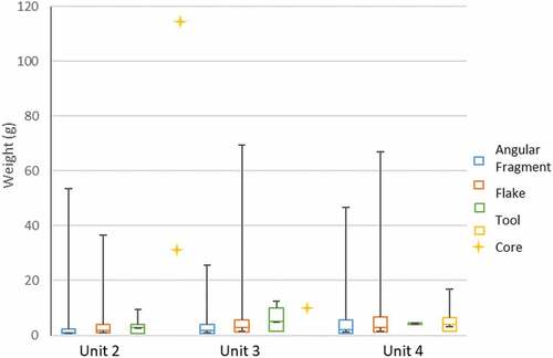
Figure 6. Maximum Length (mm) of artefact classes at Buang Merabak (please note: axial length recorded for flakes).
Raw materials
Twenty-one types of sedimentary and volcanic materials were present within the Buang Merabak assemblage (), nearly all of which are available within 20 km of the site. Sandy coloured chert, available as river cobbles or as nodules within the limestone cave or surrounding bedrock, is by far the dominant material for flake production and was consistently selected for tools (). Other lithic nodules and cobbles were sourced locally (<5 km) from the Lelet Limestone, as river cobbles from the Dalum river system, and from further south from the Jaulu Volcanics and Lemau Intrusive Complex (). Mudstone is the only material that may be derived from river beds further north near Panakiwuk (Hohnen Citation1978). Sedimentary and volcanic materials were sourced as river cobbles from local rivers, with a thin worn river cobble patina, supplemented by material obtained from natural outcrops, with a thicker, weathered cortex.
Figure 7. Proportion of raw material used for artefact classes over time at Buang Merabak.
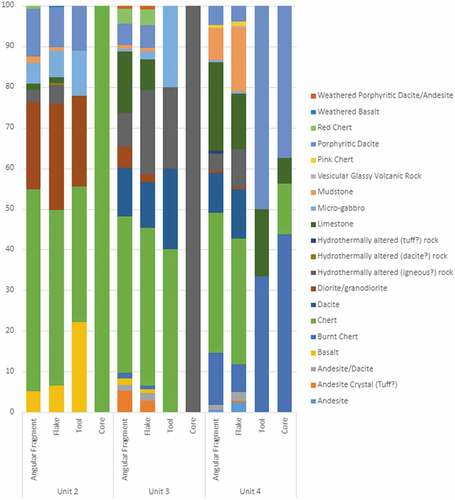
Across the three units there is a large shift in the proportions of the main lithic classes, notably an increase in volcanic materials and decline in use of some sedimentary materials: limestone, mudstone, and red and pink cherts (, ). In particular, the use of Jaulu Volcanic materials increases, resulting in the assemblage from Unit 2 consisting of sandy coloured chert and several volcanic materials, including diorite/granodiorite, porphyritic dacite, basalt, micro-gabbro, and hydrothermally altered igneous rock. The use of these volcanic materials may also mark a shift in procurement strategies, as the cortex present on the diorite/granodiorite, porphyritic dacite, micro-gabbro and basalt indicate that these were sourced from outcrops, rather than water-rolled river cobbles, suggesting that people were returning to known outcrops of trusted materials rather than searching local river systems for variable quality material.
Figure 8. Raw material proportions over time at Buang Merabak, according to artefact class.
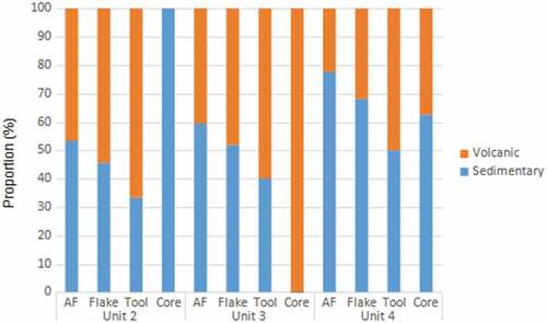
Table 3. Raw material changes over time at Buang Merabak.
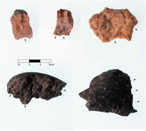
A number (n = 50) of chert artefacts show evidence of burning, such as a change in surface colour towards a pale pink, blue or white, evidence for potlidding, crazing (surface cracking) and a powdery interior that made the artefacts very fragile and lightweight, which may indicate heat treatment of stone (). Burnt chert was largely present in Unit 4 but dropped out of use in the other two periods, with only three retouched artefacts present in Unit 3. It is unclear whether the burning occurred accidently after discard or intentionally to alter the stone’s properties. However, the level of heat applied would appear to be detrimental to the chert’s properties, which may suggest either it was completed incorrectly or it was accidental. That only chert appears to be burnt may be of significance here.
Figure 9. Burnt chert artefacts from Buang Merabak.
Manufacture
As noted above, the presence of angular fragments, flakes, and cores suggests on-site manufacture, although the number of cores present is limited and no hammerstones were identified. The highest number of cores, angular fragments, and flakes are in Unit 4. The cores, with the exception of two larger cobbles of chert, are generally of small size (ranging in weight: 1.09–117.38 g; maximum length: 19–55 mm) with few appropriate platform angles remaining for flaking. All of the cores have a low number of platforms (1–3), flaking directions (1–3), and negative flake scars (1–6, although one has 12). The low numbers of flake scars and platforms suggests that they were flaked non-intensively until the core shape was unusable, then discarded. It is likely that this casual use of the cores was a result of their largely being made of limestone and chert which can be readily sourced from nearby riverbeds and outcrops. Most of the chert cores had been burnt. Of the obsidian artefacts, these were all recorded as flakes or angular fragments, with no cores or tools identified, although it is not clear if usewear was investigated (Leavesley and Read Citation2011).
Only one core of a more distant volcanic source (hydrothermally altered igneous rock) was recovered, in Unit 3. Cores of favourable non-local materials may have been flaked and then carried to the next camp for further use, although the overall small number of cores (n = 12) may indicate that this may also have occurred for locally available raw materials such as chert. The majority of the cores (n = 9) were recovered from the first occupation period (Unit 4), with one core in Unit 3 and two in Unit 2.
Use: tools
The majority of artefacts at Buang Merabak have no evidence of use, either usewear or retouch. Similar to the evidence of casual exploitation of the cores, tool production was also informal, and was limited to longer and heavier flakes/angular fragments that were then either retouched and/or used (). Of the total assemblage (n = 1043), 10% of artefacts have been retouched and/or used, classifying them as tools, and the proportion of tools remains generally low across the three occupation periods of Buang Merabak (). Many of the tools also have low intensity of use, with usewear or retouch on only 1–25% of the total edge, before breakage (). Only five tools have been retouched, with small scalar or dentate retouching for sharpening an edge.
Figure 10. The intensity of usewear (percentage of circumference of complete tools) of different raw materials at Buang Merabak.
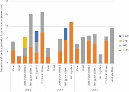
Chert and hydrothermally altered igneous rock are the only materials that are consistently used as tools over time at Buang Merabak (). Other materials are used in small amounts, including pink chert, burnt chert, limestone, dacite, and mudstone in Unit 4, micro-gabbro, porphyritic dacite, dacite, and andesite crystal tuff in Unit 3, and basalt, micro-gabbro, porphyritic dacite, and diorite/granodiorite in Unit 2. Retouched tools are limited to chert, burnt chert and basalt. These results indicate that volcanics and cherts are the main focus of the Buang Merabak assemblage, with chert the most dominant raw material used as tools across all units. Limestone is the second most common tool in Unit 4 but then reduces in importance with volcanics such as porphyritic dacite and diorite/granodiorite increasing in number ().
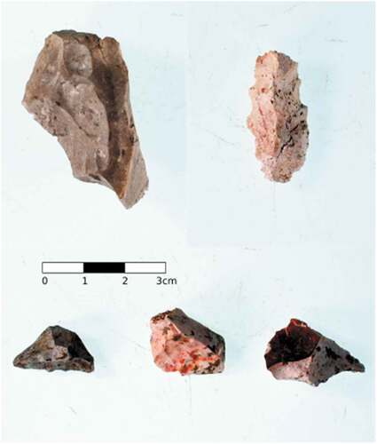
Figure 11. Basalt and chert tools with macroscopic usewear present on one or more edges.
Intensity of use was generally low across all materials but with higher intensities for volcanics (). The proportion of volcanic artefacts with high amounts of usewear also increases over time, again suggesting an increase focus on the use of these raw materials.
Discussion
The tool technology in play during the three occupation phases at Buang Merabak produced a large number of small-sized flakes and angular fragments of a wide range of local volcanic and sedimentary materials sourced from river beds and outcrops in the surrounding rainforest. However, there are subtle changes in the lithic technology, primarily with regard to procurement strategies that can be contrasted to the faunal model described by Leavesley (Citation2004) to investigate landscape use in a holistic fashion. To begin with, the initial occupation of the cave was suggested to be for the specialised hunting of bats, particularly Dobsonia sp. This indicates that the cave was itself a destination as part of a mobile hunting/gathering strategy. This mobility and destination is mirrored in the lithic technology, as it is during this early stage of occupation that the widest variety of raw materials are present, indicating sourcing from multiple locations across the landscape. However, the lithic technology is also dominated in this period by locally available chert and limestone, hence the lithic sources of the cave itself may indicate its use as a double procurement strategy, for both bats and lithic material.
In the second stage of occupation, Unit 3, there is a change to the resources available, through the introduction of cuscus (Phalanger orientalis) from the mainland and the importing of obsidian from New Britain, although the amount of obsidian is limited. Both of these introductions represent a transformation of the faunal and the lithic landscapes, moving beyond utilising what is locally available to actually implementing an artificial change in the resource structure. This is an important conceptual step, moving from utilising the local landscape to modifying and manipulating it. However, at this stage, there appears to be little local impact upon the lithic technology at Buang Merabak, which suggests that despite changes to the resource structure, the overall lithic technology was still suitable as a response to these changes.
In the final stage of occupation, Unit 2, there is a divergence in lithic and faunal use. For the fauna, shellfish exploitation changes in this time period, with an increase in shellfish diversity mirrored by a decrease in shellfish size, likely as a result of overexploitation. At the same time, it is during this period that cuscus becomes the dominant protein source. In contrast, the lithic sources decrease in diversity, with a greater focus on higher quality material obtained from known outcrops in the Lemau Intrusive Complex. This divergence can be explained as a result of the different nature of the faunal and lithic resource structure. The overexploitation of faunal species requires a shift in procurement strategies to procure a similar resource base. The procurement of lithic raw material, however, has not shifted as a result of overexploitation, but is more likely to represent a refinement of procurement strategies, where known resources of high-quality raw materials have become the focus of targeted use.
The lithic technology of Buang Merabak can also be compared to contemporary sites in New Ireland, such as Panakiwuk, Balof 2, Matenbek and Matenkupkum, although these sites still remain to have more substantial discussions of their lithics published. In New Ireland, the lithic technologies of its small hunter gatherer population remained relatively stable across tens of thousands of years, from first colonisation in the late Pleistocene into the early Holocene. This employment of a small and unspecialised flaked tool kit, with infrequent retouch, continued against a scene of changing subsistence and procurement behaviors during the Last Glacial Maximum. Such a pattern contrasts with developments in larger tool types with formal morphologies on mainland Sahul, such as waisted tools in PNG and ground stone axes in Australia and may be evidence of the isolation of the Bismarck communities following initial colonisation, as seen in the genetic evidence.
Although it is not clear why a small tool and flake technology persisted in the Bismarck Archipelago, it could be argued that the use of these small informal tools reflects a technological strategy suited to the specific resource structure of New Ireland, both in terms of geology but also subsistence resources. To begin with, quality raw materials appear relatively abundant within the New Ireland landscape, therefore raw material can be acquired with relative ease, meaning that tool use can be expedient and casual, reflecting the informal nature of the technology. At the same time, a small and low weight tool kit that is portable but also highly adaptable in terms of uses, may be more suitable for groups that are highly mobile. These strategies are a mixture of what Kuhn (Citation1994, Citation2004) describes as provisioning the individual (or the use of mobile tool kits) and provisioning the activity (where raw material is acquired and used as needed, which is possible in rich raw material landscapes).
In terms of hunting strategies, there are no large terrestrial protein sources present in New Ireland, with bats and subsequently cuscus, the main terrestrial meat sources. Neither of these species are usually hunted with a lithic technology (Bulmer Citation1968; Hawkins, O’Connor, and Kealey Citation2016; Leavesley Citation2004), with the exception of axes which are often used to fell trees which may have cuscus present (Bulmer Citation1968), which also means that there was little need from the resource base to create a specialised or formal lithic technology for hunting purposes. Subsistence challenges were also not seasonal but geographical (Gosden and Robertson Citation1991, 21). A mobile toolkit made up of a large number of consistent, small flakes in easily accessible but quality material supported human mobility between patches of rainforest bound cuscus or caves that provided bats.
Around 20,000 BP there is a major shift with introductions of cuscus from mainland PNG and obsidian from several locations in New Britain. Around this time, populations in the Bismarcks are evidently on the move, possibly with a slight population increase, with new settlements at Matenbek in south New Ireland and at Balof 2 and Panakiwuk in the north. The long distance import of obsidian from New Britain is indicative of increasing frequency of interactions between island groups and the defining of social territories (Summerhayes Citation2007) as instead of humans travelling to and staying at a direct source, they are returning home with newly acquired resources, whether through trade, gifting, or other social exchange. Connectivity throughout the Bismarcks in this period appears to be stronger, with inter- and intra-island relationships between small groups over thousands of years being developed through transport and trade of resources.
The use of stone resources on New Ireland transitioned from a period of exploration and experimentation towards preference of several key materials, with shifts from siliceous rocks in the initial stages to increasing use of volcanics at the sites of Buang Merabak, Matenkupkum, Matenbek, Panakiwuk and Balof 2 (Summerhayes and Ford Citation2014). This shift in procurement strategies may reflect different behaviours. It has been argued above that the process at Buang Merabak identifies landscape learning and a resulting preference for certain materials that were of higher quality. However, for other sites, such as Matenkupkum and Matenbek, the focus on volcanics has been considered to result from the depletion of siliceous rocks from the landscape over time, therefore the shift may have been of necessity rather than choice (Allen, Gosden, and White Citation1989; Leavesley and Allen Citation1998). Alternatively, it may also be argued that shifts in mobility may have caused changes in raw material procurement strategies as previously used sources may have been more difficult to access, although this is contrary to the Buang Merabak evidence which shows that more distant volcanic sources were increasing in use. The problem here is that without knowing the exact geological origin of many of the raw materials being discussed, understanding the behaviours that drove changes in raw material selection are difficult to interpret. There is a clear need here to understand more fully the structure of the geological landscape available to the first colonists of New Ireland and the quality of the raw materials.
In summary, while the logistics of exploitation of the coastal forest and marine environments were somewhat altered on New Ireland around the LGM with the introduction of cuscus and over-exploitation of shellfish, the focus of resource gathering within the same environmental zones and the environmental make up itself (species present, biodiversity, and climate) changed little from the late Pleistocene to the early Holocene. Population size is also estimated to have stayed small. Therefore, a small and flexible flake toolkit was the most suitable within a mobile hunter gatherer subsistence system, utilising abundant and reliable volcanic and sedimentary materials. Editing of this toolkit over time occurred as these groups identified the best available lithic materials within relatively easy reach of hunting bases.
Conclusion
Intentional introductions of important mammal species and lithic materials from nearby PNG islands highlight the adaptation and manipulation of a narrow and mountainous landscape covered in tropical equatorial rainforest by people. A small and portable stone tool technology utilising local abundances of stone, supplemented by small amounts of high-quality exotic obsidian, is evident at Buang Merabak. By viewing this technology and toolkit within the context of late Pleistocene to early Holocene small island environments, migration, and resource translocations it is clear that the ‘simple’ technology of the Bismarck Archipelago is intrinsically tied to human adaptation to different geological and subsistence constraints to those of the larger landmasses of New Guinea and Australia.
Acknowledgments
We would like to thank the National Research Institute of Papua New Guinea; Jim Robbins who facilitated the research; the National Museum and Art Gallery of PNG and in particular Pam Swadling and the late Herman Mandui; the New Ireland Provincial Administration for approval of our research, and Tuvu Telexas and Michael Boxos, the traditional owners of Buang Merabak.
Disclosure statement
No potential conflict of interest was reported by the author(s).
Additional information
Notes on contributors
Georgia Kerby
Georgia Kerby is a consultant archaeologist for Geometria Ltd., based in Northland, New Zealand. She specialises in New Zealand material culture analysis and is currently part of a research team investigating exotic artefacts from early Maori archaeological sites and implications for voyaging connections with east Polynesia.
Anne Ford
Anne Ford is a lithic specialist based in the Archaeology program at the University of Otago, Dunedin, New Zealand. She works with both flaked and ground stone assemblages from the late Pleistocene through to the Holocene from the Asia Pacific region, investigating questions relating to raw material procurement and sourcing, and how technological organization can be seen as reflective of environmental, economic, social, and cultural strategies.
Glenn R. Summerhayes
Glenn Summerhayes has been Professor of Anthropology of the University of Otago since 2005. He has worked on the archaeology of the Western Pacific PNG for the last 40 years.
Matthew G. Leavesley
Matthew Leavesley is Associate Professor at the University of Papua New Guinea. He specialises in the archaeology of PNG.
J. Michael Palin
J. Michael Palin is a geologist at the University of Otago. His research involves measuring the elemental and isotopic compositions of natural materials to understand their origin and history.
References
- Allen, J. 2017. “Yes, Virginia, There Is a Santa Claus; He Just Doesn’t Bring Presents to Children Who Don’t Believe in Him.” Australian Archaeology 83 (3): 163–165. doi:10.1080/03122417.2017.1408535.
- Allen, J., and C. Gosden. 1996. “Spheres of Interaction and Integration: Modelling the Culture History of the Bismarck Archipelago.” In Oceanic Culture History: Essays in Honour of Roger Green, edited by J. Davidson, G. Irwin, F. Leach, A. Pawley, and D. Brown, 183–197. Dunedin North: New Zealand Journal of Archaeology Special Publications.
- Allen, J., C. Gosden, and J. P. White. 1989. “Human Pleistocene Adaptations in the Tropical Island Pacific: Recent Evidence from New Ireland, a Greater Australian Outlier.” Antiquity 63: 548–561. doi:10.1017/S0003598X00076547.
- Allen, J., and J. O’Connell. 2014. “Both Half Right: Updating the Evidence for Dating First Human Arrivals in Sahul.” Australian Archaeology 79: 86–108. doi:10.1080/03122417.2014.11682025.
- Balean, C. 1989. “Caves as Refuge Sites: An Analysis of Shell Material from Buang Merabak, New Ireland.” Unpublished BA(Hons) thesis, Australian National University.
- Balme, J., and S. O’Connor. 2014. “Early Modern Humans in Island Southeast Asia and Sahul: Adaptive and Creative Societies with Simple Lithic Industries.” In Southern Asia, Australia and the Search for Human Origins, edited by R. Dennell and M. Porr, 164–174. Cambridge: Cambridge University Press.
- Bergström, A., S. J. Oppenheimer, A. J. Mentzer, K. Auckland, K. Robson, R. Attenborough, M. P. Alpers, et al. 2017. “A Neolithic Expansion, but Strong Genetic Structure, in the Independent History of New Guinea.” Science 357: 1160–1163. doi:10.1126/science.aan3842.
- Bulmer, R. 1968. “The Strategies of Hunting in New Guinea.” Oceania 38: 302–318. doi:10.1002/j.1834-4461.1968.tb00975.x.
- Choin, J., J. Mendoza-Revilla, L. R. Arauna, S. Cuadros-Espinoza, C. Cassar, M. Larena, A. M.-S. Ko, et al. 2021. “Genomic Insights into Population History and Biological Adaptation in Oceania.” Nature 592: 583–589. doi:10.1038/s41586-021-03236-5.
- Clarkson, C., Z. Jacobs, B. Marwick, R. Fullagar, L. Wallis, M. Smith, R. G. Roberts, et al. 2017. “Human Occupation of Northern Australia by 65,000 Years Ago.” Nature 457: 306–310. doi:10.1038/nature22968.
- Clarkson, C., M. Smith, B. Marwick, R. Fullagar, L. A. Wallis, P. Faulkner, T. Manne, et al. 2015. “The Archaeology, Chronology and Stratigraphy of Madjedbebe (Malakunanja II): A Site in Northern Australia with Early Occupation.” Journal of Human Evolution 83: 46–64. doi:10.1016/j.jhevol.2015.03.014.
- Downie, J.E., and J.P. White. 1978. “Balof Shelter, New Ireland-Report on a Small Excavation.” Records of the Australian Museum 31 (19): 762–802.
- Ford, A. 2011. “Learning the Lithic Landscape: Using Raw Material Sources to Investigate Pleistocene Colonisation in the Ivane Valley, Papua New Guinea.” Archaeology in Oceania 46: 42–53. doi:10.1002/j.1834-4453.2011.tb00098.x.
- Ford, A. 2017. “Late Pleistocene Lithic Technology in the Ivane Valley: A View from the Rainforest.” Quaternary International 448: 31–43. doi:10.1016/j.quaint.2016.05.030.
- Ford, A., and P. Hiscock. 2021. “Axe Quarrying, Production, and Exchange in Australia and New Guinea.” In The Oxford Handbook of the Archaeology of Indigenous Australia and New Guinea, edited by I. J. McNiven and B. David. doi:10.1093/oxfordhb/9780190095611.013.22.
- Freslov, J. 1989. “Structure and Form in an ‘Amorphous’ Lithic Assemblage: a case study from New Ireland, Papua New Guinea.” Unpublished Honours thesis, La Trobe University.
- Gosden, C., and N. Robertson. 1991. “Models for Matenkupkum: Interpreting a Late Pleistocene Site from Southern New Ireland, Papua New Guinea.” In Report of the Lapita Homeland Project, edited by J. Allen and C. Gosden, 20–45. Canberra: Department of Prehistory, Research School of Pacific Studies, Australian National University.
- Hawkins, S., S. O’Connor, and S. Kealey. 2016. “Late Quaternary hominin-bat (Chiroptera) Interactions in the Asia Pacific.” Archaeology in Oceania 51 (1): 7–17. doi:10.1002/arco.5084.
- Heaton, T.J., P. Köhler, M. Butzin, E. Bard, R. W. Reimer, W. E .N. Austin, C. Bronk Ramsey, et al. 2020. “Marine 20 – The Marine Radiocarbon Age Calibration Curve (0–55,000 Cal BP).” Radiocarbon 62 (4): 779–820. doi:10.1017/RDC.2020.68.
- Henham, A., and M. Leavesley. 2004. “Buang Merabak TP1A Stone Artefacts.” In Trees to the Sky: Prehistoric Hunting in New Ireland, Papua New Guinea, edited by M. Leavesley, 260–265. Unpublished PhD thesis. Canberra: Australian National University.
- Hiscock, P., S. O’Connor, J. Balme, and T. Maloney. 2016. “World’s Earliest ground-edge Axe Production Coincides with Human Colonisation of Australia.” Australian Archaeology 82 (1): 2–11. doi:10.1080/03122417.2016.1164379.
- Hohnen, P. D. 1978. Geology of New Ireland, Papua New Guinea. Bureau of Mineral Resources, Geology and Geophysics Bulletin no. 194, PNG 12, Australian Government Publishing Service.
- Holdaway, S., and N. Stern. 2004. A Record in Stone: The Study of Australia’s Flaked Stone Artefacts. Melbourne: Museum Victoria.
- Kuhn, S. L. 1994. “A Formal Approach to the Design and Assembly of Mobile Toolkits.” American Antiquity 59 (3): 426–442. doi:10.2307/282456.
- Kuhn, S. L. 2004. “Upper Paleolithic Raw Material Economies at Üçağizil Cave, Turkey.” Journal of Anthropological Archaeology 23: 431–448. doi:10.1016/j.jaa.2004.09.001.
- Leavesley, M. G. 2004. “Trees to the Sky: Prehistoric Hunting in New Ireland, Papua New Guinea.” Unpublished PhD thesis, Australian National University.
- Leavesley, M. G. 2005. “Prehistoric Hunting Strategies in New Ireland, Papua New Guinea: The Evidence of the Cuscus (Phalanger Orientalis) Remains from Buang Merabak Cave.” Asian Perspectives 44 (1): 207–218. doi:10.1353/asi.2005.0010.
- Leavesley, M. G., and J. Allen. 1998. “Date, Disturbance and Artefact Distributions: Another Analysis of Buang Merabak, a Pleistocene Site on Papua New Guinea.” Archaeology in Oceania 33: 63–82. doi:10.1002/j.1834-4453.1998.tb00405.x.
- Leavesley, M. G., M. Bird, L. K. Fifield, P. A. Hausladen, G. M. Santos, and M. L. Di Tada. 2002. “Buang Merabak: Early Evidence for Human Occupation in the Bismarck Archipelago.” Australian Archaeology 54: 55–57. doi:10.1080/03122417.2002.11682070.
- Leavesley, M. G., and J. Chappell. 2004. “Buang Merabak: Additional Early Radiocarbon Evidence of the Colonisation of the Bismarck Archipelago, Papua New Guinea.” Antiquity 78 (301). http://antiquityacuk/ProjGall/leavesley/indexhtml
- Leavesley, M. G., and C. Read. 2011. “Late-Pleistocene and Holocene Obsidian Transfer in the Bismarck Archipelago, Papua New Guinea.” Pacific Studies 34 (1): 24–34.
- Marshall, B., and J. Allen. 1991. “Excavations at Panakiwuk Cave, New Ireland.” In Report of the Lapita Homeland Project, edited by J. Allen and C. Gosden, 59–91. Canberra: Department of Prehistory, Research School of Pacific Studies, Australian National University.
- Mijares, A. S., F. Detroit, P. Piper, R. Grun, P. Bellwood, M. Aubert, G. Champion, N. Cuevas, A. De Leon, and E. Dizon. 2010. “New Evidence for a 67,000-year-old Human Presence at Callao Cave, Luzon, Philippines.” Journal of Human Evolution 59: 123–132. doi:10.1016/j.jhevol.2010.04.008.
- Nagle, N., M. van Oven, S. Wilcox, S. van Holst Pellekaan, C. Tyler-Smith, Y. Xue, K. N. Ballantyne, et al.; the Genographic Consortium. 2017. “Australian Aboriginal Mitochondrial Genome Variation – An Increased Understanding of Population Antiquity and Diversity.” Nature Scientific Reports 7: 43041. doi:10.1038/srep43041.
- O’Connell, J. F., J. Allen, and K. Hawkes. 2010. “Pleistocene Sahul and the Origins of Seafaring.” In The Global Origins and Development of Seafaring, edited by A. Anderson, J. H. Barrett, and K. V. Boyle, 57–68. Cambridge: McDonald Institute of Archaeological Research.
- O’Connell, J. F., J. Allen, M. A. J. Williams, A. N. Williams, C. S. M. Turney, N. A. Spooner, J. Kamminga, G. Brown, and A. Cooper. 2018. “When Did Homo Sapiens First Reach Southeast Asia and Sahul?” PNAS 115 (34): 8482–8490. doi:10.1073/pnas.1808385115.
- Pavlides, C. 2004. “From Misisil Cave to Eliva Hamlet: Rediscovering the Pleistocene in Interior West New Britain.” Records of the Australian Museum Supplement 29: 97–108. doi:10.3853/j.0812-7387.29.2004.1406.
- Rosenfeld, A. 1997. “Excavation at Buang Merabak, Central New Ireland.” Bulletin of the Indo-Pacific Prehistory Association 16 (3): 213–224. doi:10.7152/bippa.v16i0.11662.
- Shackelford, L., F. Demeter, K. Westaway, P. Duringer, J. L. Ponche, T. Sayavongkhamdy, J. X. Zhao, et al. 2018. “Additional Evidence for Early Modern Human Morphological Diversity in Southeast Asia at Tam Pa Ling, Laos.” Quaternary International 466: 93–106. doi:10.1016/j.quaint.2016.12.002.
- Summerhayes, G. R. 2007. “Island Melanesian Pasts: A View from Archaeology.” In Genes, Language and Culture History in the Southwest Pacific, edited by J Friedlaender, 10–35. New York: Oxford University Press.
- Summerhayes, G. R., and J. Allen. 1993. “The Transport of Mopir Obsidian to Late Pleistocene New Ireland.” Archaeology in Oceania 28: 144–148. doi:10.1002/j.1834-4453.1993.tb00305.x.
- Summerhayes, G. R., J. H. Field, B. Shaw, and D. Gaffney. 2016. “The Archaeology of Forest Exploitation and Change in the Tropics during the Pleistocene: The Case of Northern Sahul (Pleistocene New Guinea).” Quaternary International 448: 14–30. doi:10.1016/j.quaint.2016.04.023.
- Summerhayes, G. R., and A. Ford. 2014. “Late Pleistocene Colonisation and Adaptation in New Guinea: Implications for Modelling Modern Human Behaviour.” In Southern Asia, Australia and the Search for Human Origins, edited by R. Dennell and M. Porr, 213–227. Cambridge: Cambridge University Press.
- Tobler, R., A. Rohrlach, J. Soubrier, P. Bover, B. Lllamas, J. Tuke, N. Bean, et al. 2017. “Aboriginal Mitogenomes Reveal 50,000 Years of Regionalism in Australia.” Nature 544: 180–184. doi:10.1038/nature21416.
- Torrence, R., V. Neall, T. Doelman, E. Rhodes, C. McKee, H. Davies, R. Bonetti, et al. 2004. “Pleistocene Colonisation of the Bismarck Archipelago: New Evidence from West New Britain.” Archaeology in Oceania 39: 101–130. doi:10.1002/j.1834-4453.2004.tb00568.x.
- Veth, P., I. Ward, T. Manne, S. Ulm, K. Ditchfield, J. Dortch, F. Hook, et al. 2017. “Early Human Occupation of a Maritime Desert, Barrow Island, North-West Australia.” Quaternary Science Reviews 168: 19–29. doi:10.1016/j.quascirev.2017.05.002.
- Westaway, K. E., J. Louys, R. D. Awe, M. Morwood, G. J. Price, J. X. Zhao, M. Aubert, et al. 2017. “An Early Modern Human Presence in Sumatra 73,000–63,000 Years Ago.” Nature 548 (7667): 322–325. doi:10.1038/nature23452.
- White, J. P., T. F. Flannery, R. O’Brien, R. V. Hancock, and L. Pavlish. 1991. “The Balof Shelters, New Ireland.” In Report of the Lapita Homeland Project, edited by J. Allen and C. Gosden, 46–58. Canberra: Department of Prehistory, Research School of Pacific Studies, Australian National University.
- White, J. P., and J. F. O’Connell. 1982. A Prehistory of Australia, New Guinea and Sahul. Sydney: Academic Press.
- Wickler, S. 2001. The Prehistory of Buka: A Stepping Stone Island in the Northern Solomons. Canberra: Centre of Archaeological Research, Australian National University.