
ABSTRACT
Ongoing archaeometallurgical research at the Royal City of Meroe and the nearby Meroitic town of Hamadab in Sudan has established the presence of a Kushite iron production tradition spanning over one thousand years. Potentially from as early as the seventh century BC to as late as the sixth century AD, a significant quantity of iron was produced at Meroe, while Hamadab appears to have started producing iron during the latter stages of this time-frame. Previous investigations assumed that the iron ore exploited for use was widely available and easily accessible, close to the ancient city itself. This paper presents the results of archaeological and geological research that has, for the first time, identified ancient iron mining activity in the area. Insights gained into certain aspects of the ore procurement stage of the chaîne opératoire of Meroitic iron production, including the nature of the mined ores and the manner in which this activity was conducted, are presented. Indications as to the organisation of mining activities are also provided. The significant potential of this avenue of research is highlighted and potential future research questions are posed.
RESUMÉ
Les recherches archéométallurgiques en cours dans la ville royale de Méroé et dans la ville méroïtique voisine de Hamadab, Soudan, ont établi l’existence d'une tradition de production du fer koushite s'étendant sur plus de mille ans. Potentiellement aussi tôt que le septième siècle avant J.C. et jusqu'au sixième siècle après J.C., une quantité significative de fer fut produite à Méroé, et Hamadab semble avoir commencé à produire du fer au cours des dernières phases de cette période. Les études antérieures ont supposé que le minerai de fer exploité était largement disponible et facilement accessible, à proximité de la ville elle-même. Cet article présente les résultats de recherches archéologiques et géologiques qui ont, pour la première fois, identifié une activité minière ancienne dans la région. Certains aspects de l'étape d'approvisionnement en minerai de la chaîne opératoire de la production de fer méroïtique, y compris la nature des minerais extraits et la manière dont cette activité fut menée, sont présentés. Des indications sur l'organisation des activités minières sont également fournies. Le potentiel significatif de cette avenue de recherche est mis en évidence, et de possibles questions de recherche future posées.
Introduction
‘Iron ore is found freely on the surface of the Nubian sandstone which forms large areas of the northern Sudan … There is, therefore, no question but that Meroe was well situated as regards supplies of iron ore’ (Wainwright Citation1945: 20–21).
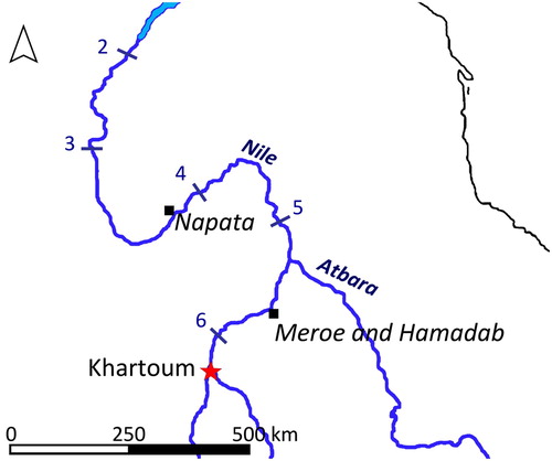
Figure 1. Map showing the locations of Napata, Meroe and Hamadab along the River Nile.
During its prime, the city was aesthetically and architecturally impressive, especially for the political and religious élite who had access to the innermost sanctuaries of its beautifully decorated temples, shrines and palaces (Garstang Citation1910, Citation1911; Wolf et al. Citation2009). Imported objects from across the known world mixed with locally produced goods and traditions, resulting in a rich and varied material culture (Bianchi Citation2004: 232–260). Those involved in various stages of the chaîne opératoire of the multitude of technologies undertaken at Meroe would have played a significant role in day-to-day life. The production of ceramics and iron, as well as of plaster and bricks, organic articles and luxury items, conceivably involved large portions of the population. The products of these technologies supported both the functional (e.g. agricultural and architectural) and non-functional (e.g. adornment) requirements of Meroe and the numerous Meroitic settlements found in its hinterland (Edwards Citation2004: 141–181).
For over a hundred years the immense remains of ancient iron production found at Meroe have captured the attention of scholars (Garstang et al. Citation1911: 21; Sayce Citation1912: 55; Wainwright Citation1945; Arkell Citation1961; Trigger Citation1969; Tylecote Citation1970; Shinnie and Kense Citation1982; Rehren 1996; Haaland Citation2014; Humphris Citation2014; Humphris and Rehren Citation2014). Impressed not only by the apparently significant quantities of iron produced (evidenced by the large slag mounds that dominate the site; Carey et al. in press) and by the socio-economic implications of the vast quantities of labour and raw materials required to support such a level of production, archaeologists have long contemplated the source of the iron ores smelted at the site. The blackish ferruginous (iron-impregnated) sandstone that occurs abundantly in the region, likely that referred to by Wainwright (Citation1945), was long assumed to be this source. Its proliferation in the area led many to hypothesise that this ore was not only easily accessible, but also amply available close to Meroe and most probably within the same hills on which the royal pyramid cemeteries are situated some 4 km to the east of the city. Tylecote (Citation1970: 67), for example, noted that ‘It is certain that some part of the deposit on which the northern cemetery lies is of sufficient high grade for the direct reduction process which produces high-iron slags’ (; cf. Wainwright Citation1945). However, until now definitive information concerning this fundamental aspect of what was possibly one of Africa’s most productive ancient iron technologies has been lacking, including where the iron mines were located and how the mining techniques were practised and organised.
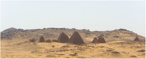
Figure 2. Meroe: view from the northern pyramid cemetery to the southern pyramid cemetery, also situated on ferruginous sandstone.
The geology of the region
The landscape to the east of Meroe is a tableland of plateaux (laterally extensive, flat-topped elevated areas) dissected by relatively small seasonal streams (wadis), as well as smaller mesas (with a width in the same range as their height) and even smaller buttes (). These features consist of sediments of the Upper Cretaceous Shendi Formation (Campanian-Maastrichtian, 84–66 Mya; Eisawi et al. Citation2012), a local stratigraphic unit of the so-called ‘Nubian Sandstone’ (Whiteman Citation1971). The Shendi Formation is dominated by cross-bedded or ripple cross-stratified, fine- to medium-grained quartz sandstones and kaolinitic mudstones. The sediments were deposited in alluvial to shallow marine environments of a low-gradient coastal plain (Bussert and Eisawi Citation2015). The formation also contains various types of supergene iron accumulations (i.e. iron enriched in the upper layers: Germann et al. Citation1990; Schwarz Citation1992; Schwarz and Germann Citation1999), topped by a flat regional planation surface, termed the ‘Shendi surface’ by Berry and Whiteman (Citation1968).
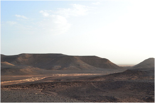
Figure 3. A plateau area to the east of Meroe, with a seasonal wadi bed marked by small outcrops of vegetation.
New archaeometallurgical investigations at Meroe
Following a twenty-year hiatus in related research (Humphris and Rehren Citation2014), in 2012 a new investigation was launched to understand Kushite iron production at Meroe and the nearby Meroitic site of Hamadab. Using a multi-disciplinary approach, this ongoing project aims to reconstruct the technology used at Meroe within a chronological framework and to position the new data within a broader context, providing a more nuanced understanding of the role of Meroe’s iron production in the political, economic, social and environmental development of Kush. Our fundamental and ultimate research question focuses on the quantity and qualities of iron produced at Meroe throughout the Kushite period. In doing so, we hope eventually to offer a calculation of the volumes of raw materials smelted and the quantities of metal produced over time, to reconstruct the smelting techniques from analysis of the waste products and to identify and understand the original iron ore used in the process.
A multi-faceted approach is being applied to the ore-related research at Meroe. A study of satellite images and ground survey of the surrounding landscape to identify possible ore and mining sites is combined with laboratory analysis of samples identified as possible archaeological ores found during excavations of the slag heaps (recognising that these samples may have been deemed unsuitable for smelting and discarded by the ancient metallurgists: Charlton and Humphris Citation2017a, Citation2017b). Additionally, a systematic experimental smelting approach has been developed to test potential ores (Charlton and Humphris Citation2017c; Humphris et al. Citation2018). The experimental approach relies on three key methods of iron extraction from samples of possible ore types collected across the hills to the north and east of the pyramids. Using a method developed by professional blacksmith Lee Sauder (Germinal Ironworks, Virginia, United States), the first involved small crucibles in which a defined weight mix of crushed charcoal and ore was heated to smelting temperature for a short period of time. The resulting iron was then weighed to determine the quality of the ore and how easily this might be smelted in a bloomery furnace. The second approach involved a small cylindrical bloomery furnace constructed and operated by iron smelter Jake Keen (The Ancient Technology Centre, Cranborne, United Kingdom), which was powered by a mechanical air supply to smelt relatively small quantities of ore to test how easily these smelted iron bloom and produced slag. The final experimental approach made use of a larger replica Meroitic furnace constructed and operated by Keen and Sauder from the dimensions of a furnace workshop excavated in 2014 using details provided in the publication of a number of furnaces excavated in the 1960s and 1970s at Meroe (Tylecote Citation1970: 67–69; Shinnie and Kense Citation1982; Shinnie and Anderson Citation2004: 73–79; Double and Humphris Citation2015; Humphris et al. Citation2018). A detailed investigation of the Peter Shinnie archives housed at the University of Calgary has also been undertaken to gather any additional, unpublished information about these features.
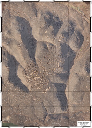
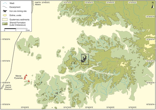
During survey dedicated to identifying possible iron ore deposits in the broader landscape as part of the approaches outlined above, a local gentleman, Mr Ali Ebeid, guided the team to a previously unrecorded location 5 km northeast of Meroe’s pyramids that consists of a plateau dominated by dozens of sediment-filled depressions. This area, now known as Meroe Mining Area 1 (MMA 1), was identified as a probable Meroitic iron ore mining location ().
Figure 4. Aerial image of MMA 1. Note the sand-filled depressions pock-marking the plateau (map produced by Frank Stremke).
Archaeological and geological investigations at MMA 1
A detailed investigation of the geological ores collected as part of the research at MMA 1 is currently underway and the results of laboratory analysis of various ores collected and trialled during the experimental and preliminary geological investigations are presented elsewhere (Charlton and Humphris Citation2017a, Citation2017b, Citation2017c; Humphris et al. Citation2018; Bussert et al. in press). A summary of the new insights gained into the ancient mining activities and the extracted ores is provided here.
Archaeological insights
Initial observations at MMA 1 led to a hypothesis that the sediment-filled depressions dominating the plateau were in-filled mine shafts, similar in style to the famous ancient copper mine shafts of Timna in southern Israel (Craddock Citation1995: 64–69). On the African continent, while gold, copper and iron minerals can, in some areas, easily be collected close to or at the surface, or from river beds (Herbert Citation1998), numerous examples exist of deep shaft mines excavated for the exploitation of metals and ores (Chirikure Citation2015: 45–51). Kushite proficiency in extensive excavation and extraction techniques is demonstrated across many examples, not least the impressive tombs excavated for royal burials and the Meroitic sandstone quarries, which included large galleries (Cech et al. Citation2018). Numerous Meroitic sites also had wells excavated in the same manner as a mine shaft. For example, the well found in the temple forecourt at the site of Hamadab is thought to have been 4-5 m deep (Wolf Citation2015).
Excavations across the MMA 1 plateau aimed at revealing the techniques used during the ancient mining activities and the nature of the mined deposits. In total, six of the sediment-filled depressions visible in the aerial image shown in were excavated. Three of these were isolated depressions: M1 was an approximately 4 × 5 m sediment trap surrounded by an approximately 1 m high semi-circular bank of spoil situated towards the east of the plateau; M3 was approximately 4 m in diameter and was situated at the northern edge of the plateau escarpment; M6, with a diameter of approximately 2.5 m, was situated towards the middle of the plateau and appeared to have been mined into the highest layers of the plateau which still exist. A further three sediment-filled depressions (M2, M4 and M5) were excavated across the areas of original spoil separating the depressions ( and ). A geological trench was also excavated in an unmined location towards the higher centre of the plateau to investigate the difficulty or ease with which the rock could be ‘mined’ using simple tools and a small number of people and to reveal the original geological sequence.
Figure 5. Overview photograph of trench M2-M4-M5, with sediment traps visible in the background and the trench running through sediment traps of differing depths in the foreground.
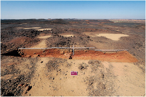
Figure 6. Overview photograph looking south of trench M2-M4-M5 showing the plateau top dotted with sediment traps.
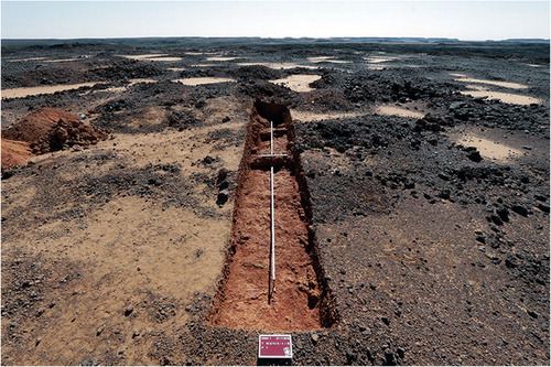
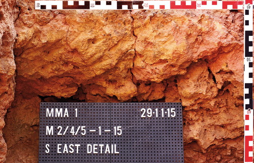
The stratigraphy and deposits revealed during the excavations demonstrate that the mining activities used in the past to extract iron ore at MMA 1 were not indicative of shaft mining. Rather, the spoil from relatively shallow ancient digging events was piled up around the newly created depressions that they made, producing traps of varying depths within which wind-blown sediments have built up over time. Thus, the shape and depth of the depressions is defined by the build-up of excavated spoil left adjacent to the depressions, rather than representing the uppermost surface of in-filled ancient mine shafts. In places, larger lenses of iron ore may have been exploited (see below) and in such cases the area was superficially separated by spoil, which was piled up as the miners moved across the landscape. Ancient tools marks indicate the occasional use of a thin, round pointed tool with a diameter of around 5 mm at the widest preserved end of the point. However, these tool marks were noted in only one location within the excavated areas (). The excavated depressions and associated areas of ancient spoil were sterile of material culture.
Figure 7. Tool marks found at the southern end of trench M2-M4-M5.
During the investigations at MMA 1, material culture was observed scattered in an apparently haphazard manner across the plateau. A trial systematic transect survey zone of 40 × 60 m, subdivided into 6 squares each of 20 × 20 m, was walked at 1 m intervals. Due to the extreme weathering of the surface of the plateau and of the material culture, which together made it particularly difficult to distinguish between natural and man-made materials, this survey was carried out with great care. Surface finds were numbered, geographically located using a differential GPS, photographed and taken for analysis where appropriate. In this comparatively small area, 288 individual finds were recorded, including 80 bricks or brick fragments, iron slag and pottery. The presence of a small quantity of slag clearly indicates that the Meroites were testing ores at this site. The very limited evidence for pottery (see below) would suggest that they were using lighter and less fragile containers such as baskets and goatskins to transport necessary materials and water. The distance any vessel would have to travel from the Royal City to the mining area, across particularly rough terrain, makes such items preferable choices for those working there.
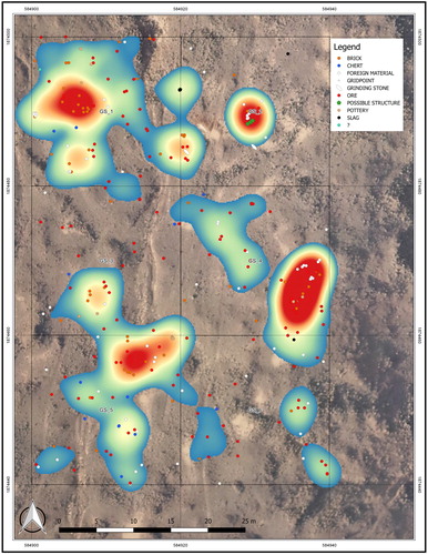
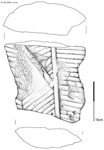
plots the occurrence of brick, iron slag and pottery in each of the six grid squares and illustrates examples of each. It appears that the presence of potsherds, although generally low (N = 11 from the whole survey area), is associated with the occurrence of larger quantities of bricks (N = 62), while slag (N = 7) is not solely linked to the occurrence of either. Pottery vessels are therefore likely to be associated with building structures, while slag was presumably produced during smelting events undertaken slightly further away from these constructions. Interestingly, as seen in , the majority of the slag fragments (6 out of 7) were found in the northern area of the survey zone, mostly in one small cluster. Pragmatic superficial survey of the rest of the plateau documented additional occurrences of slag further to the north, yet none to the south. This positioning of (testing) furnaces (assuming that the slag has not travelled far from where it was produced) could provide an indication of the spatial organisation of the mining area. The obvious areas of particularly intensive material culture distribution are documented in . Assessment of these data highlights Grid Square 1 as an area with a high frequency of material culture items, demonstrating that the organisation of the ancient mining location could be investigated further. Challenges to our potential future research include the very weathered nature of the surface of the plateau as mentioned above, as well as challenges with generating a chronological framework for the activity at MMA 1, as described below, and the possibility of material being moved around the landscape since the mining activities took place (although due to the remote location this possibility is slight).
Figure 8. MMA 1: the occurrence of pottery, bricks and iron slag within each of the six grid squares (upper left) and examples of each type of find (iron slag, right; plastered brick, lower left; pottery fragment, lower right).
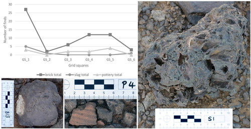
Figure 9. MMA 1: grid survey results showing the distribution of finds (map produced by Frank Stremke).
The presence of bricks across the plateau indicates that structures were constructed there, presumably associated with the mining activity. Well-established two-way transport links able to cope with heavy materials existed along cleared ancient tracks, some of which can still be seen today. That one of the bricks was plastered () could indicate the construction of ‘higher status’ buildings, considering the additional effort to bring plaster up to the plateau in addition to that needed to move the bricks themselves. Alternatively, this plastered brick could have been recycled from Meroe. Intriguingly, a fragment of a stone statue depicting clothing stylistically similar to that seen on portrayals of the kings and queens of Meroe and on the images of the gods found on Kushite temples () was also found on top of the plateau. This find suggests that during some time when the area was exploited for iron ore a statue was erected at MMA 1, perhaps to provide opportunity for the miners to worship, or as a demonstration and reminder of royal power (and even control), over mining activities. In other words, in ancient times this landscape was clearly not the isolated, barren landscape seen today. Such finds may be able to provide insights into the organisation and control of labour, questions that we plan to examine in the future using the accumulated new research on Meroitic iron production (Haaland and Haaland Citation2007; Haaland Citation2013, Citation2014; Humphris and Scheibner Citation2017).
Figure 10. The stone fragment of a statue found at MMA 1. Drawing by Bogumil Pilarski.
Geological insights
The geological investigations at MMA 1 identified various types of ironstones, defined as iron-rich sedimentary rocks with >15 wt % iron (Young Citation1989), in the form of beds or lenses. The ironstones are concentrated on and directly below the Shendi surface, where they form a weathering resistant cap or ‘duricrust’. Three main lithotypes of ironstone were differentiated in the study area: 1) beds of iron-rich sand- and mudstones with physical sedimentary structures (‘ferribands’); 2) ironstone beds with mottles, nodular, vermiform, vesicular and conglomeratic textures (‘ferricretes’); and (3) oolitic ironstones. Gradual transitions of the three principal ironstone lithotypes are common ().
Figure 11. Geological section showing the irregular contact of oolitic ironstone and ferricrete in the principal section of the mining area MMA 1 (image created by Robert Bussert).
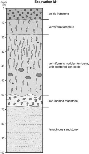
Generally, ferribands occur at different levels in the Shendi Formation. They vary in thickness from a few cm to approximately 30 cm and consist primarily of quartz grains with minor mica and kaolinite cemented by iron-minerals, primarily goethite (FeO(OH)) and, to a lesser extent, haematite (Fe2O3). Ferricretes and oolitic ironstones occur near to the top of the sedimentary section where they form the ironstone duricrust of the plateaux and mesas. Ferricretes consist of a mixture of quartz grains, minor kaolinite and mica, with goethite representing the dominant Fe-mineral. Ferricrete beds are up to 60 cm thick, while lenses up to 4 m in thickness locally fill surface depressions (Bussert et al. in press.).
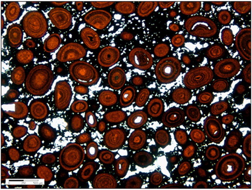
The oolitic ironstones by definition contain >5% iron ooids (Young Citation1989; Petranek and van Houten Citation1997). Ooids are concentrically structured spherical or ellipsoidal grains <2 mm in diameter that consist of a central core surrounded by laminae (Young Citation1989). The oolitic ironstones that occur in the ironstone duricrust in the mining area are dark brown to almost black and form up to three separate lenses or discontinuous beds at a maximum of 40 cm thickness. They vary from a sandy, intensely bioturbated type that contains dispersed fine-grained sand-sized iron ooids to a densely packed type free of quartz grains with ooids up to coarse-grained sand size. The iron ooids are in general moderately to poorly sorted and mostly spherical, although minor broken, ductile deformed or partly dissolved ooids are also present (). The ooids mainly consist of goethite and minor haematite and are surrounded by a fine-grained matrix of finely crystalline Fe-minerals, predominantly goethite. Densely packed goethitic oolites comprise only very little quartz, mica and kaolinite. SEM-EDS analysis has highlighted that the oolitic ironstones can contain up to 89% FeO.
Figure 12. Thin section photomicrograph under plane polarised light of an oolitic ironstone sample from MMA 1 showing spherical, ellipsoidal and partly broken iron ooids in a fine-grained goethitic matrix.
The geological field research identified a mining horizon consisting of oolitic ironstones and ferricretes preserved and exposed only on or directly below the uppermost plateau surface and on the top of mesas of similar height, around 430 m a.m.s.l. MMA 1 is the most extensively mined area, although many of the hills south and southwest of this site up to Wadi el Hawad (some 5 km south of Meroe) that expose the iron ore horizon were mined in variable intensity (; Bussert et al. in press). Mining activity seems to have preferentially followed the edges of the plateau, possibly because the lateral transport of iron in groundwater towards the rim of plateau led to precipitation of iron-oxides in these topographic positions and thus to enrichment in iron. Only occasionally does mining activity extend into the central region of hilltops. To the north and east of MMA 1 no mines appear to exist, despite the presence of high-grade oolitic ironstones in the plateau of this area.
Figure 13. Geological map of the iron ore-mining region to the north east of the Meroe pyramids. The outline of the aerial map in covering the main mining area MMA1 is drawn as a black frame (map produced by Robert Bussert).
Certain geomorphological features seem to be relevant to the formation of the iron ores and probably in part controlled the position, distribution and possibly also the quality and quantity of the ores. The surfaces of the plateau and mesas are dotted with closed sub-circular to irregular natural depressions that display many characteristics typical of sinkholes (dolines). Most sinkholes formed by subsidence due to slow dissolution of the underlying sediment and thus represent subsidence dolines, although some depressions with steeply dipping strata likely formed on top of underlying collapsed caves (collapse dolines). In cross-section the sinkholes are often filled by ferricrete. The ferricretes are either underlain by reddish iron-mottled mudstones, ferruginous sandstone or lenses or beds of oolitic ironstone. The sinkholes appear to have caused the preferred formation of iron-rich deposits in these locations, probably due to the lateral transport and redeposition of iron-rich sediments including iron ooids, and by groundwater-related secondary enrichment. The quantity and quality of the iron ore changes significantly at close distance and both the grade (iron content) and thickness of the ore are usually higher in the sinkholes. It can be suggested that the ancient miners used such features in the landscape as markers for high-grade oolitic ore. However, on the regional scale no geographic trend in thickness and macroscopically visible characteristics of the iron ore horizon is apparent, such as the content of iron ooids and quartz grains or the intensity of iron cementation. At the mining sites, high-grade ore is rare, while in areas that lack mines to the east and northeast such ore is present. This very likely reflects the intense ancient exploitation of high-grade ores at the mining sites.
Experimental insights
The experienced iron smelters tasked with replicating the Meroitic smelting process (Jake Keen and Lee Sauder) were both intuitively drawn to two types of ore located during the landscape survey, although other types of ore were also tested. The first was an ore source identified in a doline to the north of Meroe. This feature was recognised because the doline is dissected by the Khartoum/Atbara asphalt road. The second ore to capture their attention was an oolitic ore that was more difficult to identify in the landscape, found further to the east of the research area. The geological insights offered above confirm the relationship between these ore types. Both Keen and Sauder strongly believed based on their experience that these ores would yield the best results when smelted. Through the course of ten experimental smelts the oolitic ores yielded most success, although this was limited. Samples of these experimental ores have been compared to ores found in the archaeological record at a late to post-Meroitic slag mound (MIS6). The doline and oolitic ores are generally more similar in their microstructure and chemistry to the archaeological ores when compared to other ores tested during the experimental campaigns, although some differences are evident (Charlton and Humphris Citation2017a, Citation2017b; Humphris et al. Citation2018). Despite the number of experimental smelts so far conducted as part of our broader archaeometallurgical research at Meroe, information concerning the manner by which the furnace was charged with ore during a smelt, the quantities of ore added to the furnace per smelt and the ore to fuel ratio remains elusive. Results of a more recent experimental campaign that took place in autumn 2017 will be published in the future.
Discussion
The most iron-rich lithotype, the goethite oolitic ironstones, were likely the ore type preferentially mined and smelted by the Meroitic iron workers (Charlton and Humphris Citation2017a, Citation2017b, Citation2017c; Humphris et al. Citation2018). This lithotype consists primarily of goethite and minor haematite with very small quantities of other minerals present and is irregularly distributed in the uppermost horizon. It occurs in often only one, but occasionally in up to three, irregular bands or lenses of variable thickness at and near the current surface of the plateaux. The distribution of high-grade ores in the study area seems partly controlled by the presence and abundance of sinkholes, something that is also likely to be reflected by the patchy distribution of mining sites, particularly in the southern study area. The presence of typical karst (sunken) features within the sandstones of the Shendi Formation, including dissolution forms such as dolines that are typical of limestone karst, is remarkable. It is possible that the Meroitic miners started mining in sinkholes, where ores were not only more easily accessible, but probably of higher ore quantity and quality. They continued to extract ore principally along the edges of the hill escarpments, probably because of a higher ore quality in this morphological position due to lateral transport of iron.
Macroscopic inspection in the field indicated that the overall quantity and quality of iron ore does not seem to change significantly towards the east and northeast of the study area. The distribution of mining activity therefore probably reflects transport limitation and distance to the smelting sites located near to the Nile rather than geological factors. Further ground surveys were undertaken approximately 12 km to the north-northwest of MMA 1, at the famous Meroitic sandstone quarry site of Jebel Umm Ali. As at MMA 1, a less defined yet pockmarked landscape was noted with a small area of sediment-filled depressions that could represent iron ore extraction. Additional potential mining areas were identified on satellite images along the foot of the sandstone plateau between Umm Ali and the Meroe pyramids and on the plateau north of Umm Ali. All of these possible mining sites are no more than 9 km east of the Nile, but further excavations and laboratory analysis will be necessary to confirm these as Kushite mining locations. The extent of mining activities east and northeast of the Meroe pyramids, along with the possible mining activities in the direction of and around Jebel Umm Ali, would indicate that the iron smelters were testing and exploiting ores in many locations additional to MMA 1, at least at certain times during the kingdom of Kush.
The dating of the ore exploitation activity at MMA 1 is problematic. No charcoal was identified during the excavation of the mining pits and no pottery with diagnostic decoration was found that could be used to provide a chronological framework for the mining activities. One piece of charcoal was found embedded within a slag fragment collected at MMA 1. Analysed at the University of Arizona AMS facility, the sample was dated to 1583 ± 22 BP (AA-108253). Calibrated using Oxcal version 4.3 (IntCal 13 curve) at 2-sigma (95.4% probability) it gave a date range of cal. AD 419–539. Although this date places the production of this fragment of slag later than the Meroitic period, recent research has demonstrated that significant levels of iron production continued at Meroe and Hamadab during post-Meroitic times (Humphris Citation2014; Charlton and Humphris 2017; Humphris and Scheibner Citation2017). Considering the scale of iron production at Meroe and Hamadab (Carey et al. in press; Humphris in press) spanning in total over 1000 years as we now know, the extensive mining evidence outlined here is unsurprising and, we would suggest, dates to earlier periods as well as to the later period indicated by the radiocarbon date. Meroe represents the most intensive and long-term known iron production associated with the kingdom of Kush. Its proximity to iron ore that, once identified, can be easily extracted and smelted, is probably not a coincidence. Providing a chronology for the numerous mining locations in the Meroe region identified during this research may, in combination with the ongoing archaeometallurgical investigations of iron production at the site, allow us to develop a better understanding of the relationship between iron production and the evolution of Meroe as an important Kushite centre. This important question is also being pursued using a renewed focus on experimental work that attempts to quantify in more detail how much iron ore may have been smelted at any time (and concurrently how much iron and slag was produced per smelt). These new data may also help to understand the scale of mining activities in the past. A luminescence dating strategy was trialled with limited success in the early years of the current research and the mining locations may provide a good opportunity to pursue Optically Stimulated Luminescence dating of the mining spoil.
The statue fragment, the clusters of bricks and the scale of mining activity all suggest significant potential for a high-resolution investigation and spatial analysis at MMA 1. The data already available indicate that at least for a certain time there was a high level of co-ordination of labour and transport networks to obtain the material sought and transport it back to Meroe for smelting. The presence of the ancient sandstone quarries (Cech et al. Citation2018) on the route back towards Meroe from MMA 1 indicates that people were familiar with the wider landscape and were adept at distributing, organising/supporting workforces and transporting large quantities of heavy materials across quite significant distances. The fact that the relatively distant ore source of MMA 1 was exploited for iron production technology during post-Meroitic times, combined with the continuation of various technological approaches aside from the use of particular mining areas and techniques, supports the need for a review of the social, political and economic aspects of the post-Meroitic period (Humphris in press).
The paucity of tool marks within the mining areas excavated as part of this investigation was initially surprising. However, the 1.5 × 1.5 m geological trench mentioned above was excavated to a depth of approximately 1 m by a team of four in a matter of a few days. The hammers used during this test are possibly of better quality than the tools used by the Meroites, but the endeavour was not deemed particularly difficult by those involved. The rock fractured and crumbled on hammering and no tool marks were left by this activity on the newly revealed surfaces. Presumably the ancient miners employed similar tactics, only using fine tools to obtain the remains of a particularly good lens of ore at the end of a mining extraction episode, where the lens had naturally finished. Although tedious, notably in terms of accessing the site and transporting materials to and from the mining area, perhaps the ancient mining activity itself was not particularly arduous, especially if a number of people were involved in the task at one time. What was essential, however, were those with the skills to identify the correct ores to be transported back to Meroe, as opposed to the material that could be discarded as spoil, creating the sediment traps visible today.
Conclusions
It is hoped that in addition to providing the first insights into the ancient iron mines of Meroe, this paper has demonstrated the potential of applying diverse archaeological and geological approaches to the investigation of the ore acquisition stage of ancient iron production. To complement the results of the archaeological and geological investigations described here, samples obtained during the geological investigations at MMA 1 and other possible ore-rich locations across the landscape are undergoing further petrographic and geochemical analysis. Excavations of the iron slag mounds at Meroe continue, as does the experimentation. Hundreds of samples of ore and slag and associated materials have been systematically collected and are undergoing laboratory analyses with new results continuing to be produced. The research into the iron mines of Meroe presented here and our understandings of this vital stage of the chaîne opératoire of iron production will thus continue to develop. Further work at Jebel Umm Ali will, for example, reveal why two geographically distinct mining areas were possibly exploited in the past and hopefully establish whether or not they are chronologically distinct. Future investigations at MMA 1 and other locations will hopefully provide material from which a chronology of mining can be generated. Renewed intensive surveys and spatial distribution analysis should allow for a better understanding of the organisation of mining. Meanwhile, other avenues of research focusing on the charcoal used, the smelting techniques, technical ceramics and the objects produced mean that we are now closer to understanding Kushite iron production, although much research remains to be done.
Acknowledgements
This research was funded by QSAP (the Qatar Sudan Archaeology Project, mission 037) and UCL Qatar and was carried out with permission from the National Corporation for Antiquities and Museums (NCAM) in Sudan, the Director General of which, Dr Abdelrahman Ali, is thanked for his continuing support and encouragement. Mr Ali Ebeid is thanked for showing the team to the site of MMA 1. This location presented particularly tough conditions for all of the team who worked tirelessly as usual to ensure that the work was completed successfully, efficiently and professionally. Frank Stremke of Stremke Archaeology is particularly recognised for his continued provision of excellent field survey and recording, as well as for his aerial photography, work which was very difficult in the very strong winds at MMA 1, and for his post-processing of maps and other data. Steven Matthews and Alex Walmsley are thanked for their work excavating trenches at MMA 1. For their continued efforts we thank Ahmed Ali, Bilal Ali, Salim Ali, Tahir Ali, Fatahalim Bilal, Kamal Bilal, Motoquil Bilal, Abdulla Bilulla, Hamidi Fadlallah, Ali Fath Alrahman, Motoquil Hashim, Ali Ibrahim, Ali Idris, Alamin Negmadine and Bagawi Salah. We also thank Abdelhai Abdelsawi Fedlelmula, who was the NCAM inspector during the fieldwork at MMA 1, and Said Ahmed Mokhtar and Basil Kamal, who were research assistants at that time. Field school students Adam Mohammed Bahkeet, Nusaiba Abdalli Ali Nuradeen, Mustafa Mohammed Hassan Bakheit, Mohammed Nasreldeen Abdel Razegi Babeki and Tohamy Abul Gasim Khalifa El-Tohamy are thanked for their work during the grid surveys at MMA 1. Additionally, we are grateful to Lisa Atkinson (Archivist), Dr Diane Lyons and Lubna bin Zayyad for their work on the Peter Shinnie Archive at the University of Calgary. Finally, we wish to thank Thilo Rehren and Stavroula Golfomitsou for their comments on an earlier version of this paper.
Notes on contributors
Jane Humphris is a Principal Research Associate at University College London (UCL) Qatar, where she directs UCL Qatar’s archaeological research focusing on Kushite iron production at the Royal City of Meroe and other sites in Sudan. Alongside her archaeometallurgical research she continues to develop and implement community engagement and capacity-building strategies. She recently initiated a new investigation of ancient iron production in northern Ethiopia.
Robert Bussert is a geologist and sedimentologist with extensive experience of working across northeastern Africa. Based at the Technical University, Berlin, he continues to conduct his own field and laboratory research while teaching subjects including clay mineralogy, palaeogeographic reconstructions and palaeoclimatology. He has been working as the geologist for the UCL Qatar team in Sudan since 2015.
Thomas Scheibner is an archaeologist with twenty-five years of field experience at various Kushite sites in Sudan. His main specialisation is Kushite water management systems and hafirs, particularly at the site of Musawwarat es-Sufra. He has played a leading role in UCL Qatar’s archaeometallurgical research at Meroe and Hamadab since 2012.
Fareed Alshishani was a Research Assistant for UCL Qatar’s Sudan Project and as such took part in field and laboratory-based research. He is now based in Jordan where he works for the American Center of Oriental Research (ACOR) as the capacity-building co-ordinator for the SCHEP Project (Sustainable Cultural Heritage Through Engagement of Local Communities Project).
ORCID
Jane Humphris http://orcid.org/0000-0001-6963-2143
Additional information
Funding
References
- Arkell, A.J. 1961. A History of the Sudan: From the Earliest Times to 1821. London: The Athlone Press.
- Berry, L. and Whiteman, A.J. 1968. “The Nile in the Sudan.” Geographical Journal 134: 1–37. doi: 10.2307/1792135
- Bianchi, R.S. 2004. Daily Life of the Nubians. Westport: Greenwood Press.
- Bussert, R. and Eisawi, A.A.M. 2015. “Late Cretaceous tropical coastal wetlands at the southern shoreline of the Tethys in central Sudan.” In GeoBerlin2015: Dynamic Earth from Alfred Wegener to Today and Beyond; Abstracts, Annual Meeting of DGGV and DMG (Berlin 2015), edited by J. Wagner and K. Elger, 109. Potsdam: GFZ German Research Centre for Geosciences. http://gfzpublic.gfz-potsdam.de/pubman/item/escidoc:1314059/component/escidoc:1314718/Geoberlin_2015.pdf
- Bussert, R., Humphris, J., and Schomacker, R. in press. “Entstehung und archäologische Bedeutung oolithischer Eisenerze im Sudan. Formation and archaeological significance of oolitic ironstones in Sudan.” Zentralblatt für Geologie und Paläontologie
- Carey, C., Stremke, F. and Humphris, J. in press. “Investigating the ironworking remains in the Royal City of Meroe, Sudan.” Antiquity.
- Cech, B., Rehren, Th. and Mohamed, A.A (eds) 2018. The Quarries of Meroe, Sudan. Doha: Hamad Bin Khalifa University Press.
- Charlton, M.F. and Humphris J. 2017a. “Exploring ironmaking practices at Meroe, Sudan — a comparative analysis of archaeological and experimental data.” Archaeological and Anthropological Sciences https://doi.org/10.1007/s12520-017-0578-2
- Charlton, M.F. and Humphris, J. 2017b. “Exploring ironmaking practice at Meroe, Sudan — images, data, and analytical scripts. doi:10.7910/DVN/HQZOOB, Harvard Dataverse, V1, UNF:6:ThTH3cFkfE + V3mubXJBeVQ== Site accessed 23 May 2018.
- Charlton, M.F. and Humphris, J. 2017c. “HH-XRF analyses of geological, archaeological, and experimental materials at Meroe, Sudan.” doi:10.7910/DVN/4DZBQ0, Harvard Dataverse, V1, UNF:6:oOtbIfcadRTQdsBjidabYw== Site accessed 23 May 2018.
- Chirikure, S. 2015. Metals in Past Societies. A Global Perspective on Indigenous African Metallurgy. Cham: Springer.
- Craddock, P.T. 1995. Early Mining and Metal Production. Edinburgh: Edinburgh University Press.
- Double, G. and Humphris, J. 2015. “Ancient Iron, Experimental Archaeology in Sudan.” Film available at: https://www.youtube.com/watch?v=SPU8Uwa-jBQ (in English) and https://www.youtube.com/watch?v=PBCrKLx0R0I (in Arabic).
- Edwards, D.N. 2004. The Nubian Past. An Archaeology of the Sudan. London: Routledge.
- Eisawi, A.A.M. Elbashir, O.M, Babikir, I.A.A. and Ali, O.E. 2012. “Palynology and sedimentology of the Campanian-Maastrichtian Shendi Formation, central Sudan: paleoecological and paleoclimatical pmplications.” SAPEG Fifth Conference, Abstract Volume, 83–84.
- Garstang, J. 1910. “Preliminary note on an expedition to Meroe in Ethiopia.” Liverpool University Annals of Archaeology and Anthropology 3: 57–70.
- Garstang, J. 1911. Meroe: City of the Ethiopians. Oxford: Clarendon Press.
- Germann, K. Fischer, K. and Schwarz, T. 1990. “Accumulation of lateritic weathering products (kaolins, bauxite, laterites, ironstones) in sedimentary basins of northern Sudan.” Berliner Geowissenschaftliche Abhandlungen A120.1: 109–148.
- Haaland, R. 2013. “Meroitic iron working in a global Indian Ocean context.” In The World of Iron, edited by J. Humphris and T. Rehren, 146–155. London: Archetype.
- Haaland, R. 2014. “The Meroitic empire: trade and cultural influences in an Indian Ocean context.” African Archaeological Review 31: 649–673. doi: 10.1007/s10437-014-9169-0
- Haaland, R. and Haaland, G. 2007. “God of war, worldly ruler, and craft specialists in the Meroitic kingdom of Sudan: inferring social identity from material remains.” Journal of Social Archaeology 7: 373–392. doi: 10.1177/1469605307081397
- Herbert, E.W. 1998. “Mining as microcosm in precolonial sub-Saharan Africa, an overview.” In Social Approaches to an Industrial Past. The Archaeology and Anthropology of Mining, edited by B. Knapp, V.C. Pigott and E.W. Herbert, 138–154. Abingdon: Routledge.
- Herodotus. The Histories. Penguin: Harmondsworth.
- Humphris, J. 2014. “Post-Meroitic iron production: initial results and interpretations.” Sudan & Nubia 18: 121–129.
- Humphris, J. in press. “Kushite iron production at the Royal City of Meroe.” In The Oxford Handbook of Ancient Nubia, edited by G. Emberling and B. Williams. Oxford: Oxford University Press.
- Humphris, J. and Rehren, T. 2014. “Iron production and the Kingdom of Kush.” In Ein Forscherleben zwischen den Welten, edited by A. Lohwasser and P. Wolf, 177–190. Berlin: Sonderheft MittSAG.
- Humphris, J. Charlton, M.F., Keen, J., Sauder, L. and Alshishani, F. 2018. “Iron smelting in Sudan: experimental archaeology at the Royal City of Meroe.” Journal of Field Archaeology 43: 399–416. doi: 10.1080/00934690.2018.1479085
- Humphris, J. and Scheibner, T. 2017. “A new chronology for iron production at Meroe.” African Archaeological Review 34: 377–413. doi: 10.1007/s10437-017-9267-x
- Petranek, J. and Van Houten, F.B. 1997. “Phanerozoic ooidal ironstones.” Czech Geological Survey, Special Paper 7: 1-71.
- Pope, J. 2014. The Double Kingdom under Taharqo: Studies in the History of Kush and Egypt, c. 690–664 BC. Leiden: Brill.
- Rehren, T. 2001. “Meroe, iron and Africa.” Mitteilungen der Sudanarchäologischen Gesellschaft 12: 102–109.
- Reisner, G.A. 1923. “The Meroitic kingdom of Ethiopia. A chronological outline.” Journal of Egyptian Archaeology 9: 34–77. doi: 10.1177/030751332300900104
- Sayce, A.H. 1912. “Second interim report on the excavations at Meroë in Ethiopia, Part II – The historical results.” Liverpool Annals of Archaeology and Anthropology 4: 55–65.
- Schwarz, T. 1992. “Produkte und Prozesse exogener Fe-Akkumulation: Eisenoolithe und lateritische Eisenkrusten im Sudan.” Berliner Geowissenschaftliche Abhandlungen A142: 1–186.
- Schwarz, T. and Germann, K. 1999. “Weathering surfaces, laterite-derived sediments and associated mineral deposits in north-east Africa.” In Thiry, M. and Simon-Coinçon R., eds. Palaeoweathering, Palaeosurfaces and Related Continental Deposits, edited by M. Thiry and R. Simon-Coinçon, 367–390. Oxford: Blackwell Science Ltd.
- Shinnie, P.L and Bradley, R.J. 1980. The Capital of Kush 1. Meroe Excavations 1965–1972. Wiesbaden: Harrasowitz Verlag.
- Shinnie, P.L. and Anderson, J.R. 2004. The Capital of Kush 2. Meroe Excavations 1973–1984. Wiesbaden: Harrasowitz Verlag.
- Shinnie, P.L. and Kense F.J. 1982. “Meroitic iron working.” Meroitica 6: 17–28.
- Török, L. 1997. The Kingdom of Kush. Handbook of the Napatan-Meroitic Civilization. Leiden: Brill.
- Trigger, B.G. 1969. “The myth of Meroe and the African Iron Age.” African Historical Studies 2: 23–50. doi: 10.2307/216325
- Tylecote, R.F. 1970. “Iron working at Meroe, Sudan.” Bulletin of the Historical Metallurgy Group 4: 23–50.
- Wainwright, G.A. 1945. “Iron in the Napatan and Meroitic Ages.” Sudan Notes and Records 26: 5–36.
- Whiteman, A.J. 1971. The Geology of the Sudan Republic. Oxford: Oxford University Press.
- Wolf, S. Hof, C. and Onasch H-U. 2009. “Investigations in the so-called Royal Baths at Meroe in 2000, 2004 and 2005. A preliminary report.” Kush 19: 101–116.
- Wolf, P. 2015. “The Qatar-Sudan Archaeological Project – The Meroitic town of Hamadab and the palaeo-environment of the Meroe region.” Sudan & Nubia 19: 115–131.
- Young, T.P. 1989. “Phanerozoic ironstone: an introduction and review.” In Young, T.P. and Taylor, W.G.E. eds. Phanerozoic Ironstones, edited by T.P. Young and W.G.E. Taylor, 9–25. London: The Geological Society.