
ABSTRACT
Dendi Lake Rockshelter is situated about 100 km west of Addis Ababa on the west-central part of the Ethiopian Plateau in the Ginchi woreda of Ethiopia’s Oromiya regional state. In October 2012, a team from the University of Cologne excavated a test-trench that revealed four archaeological complexes that could clearly be distinguished on a typological basis as well as by radiocarbon dates. This article focuses on the lithic artefacts recovered from the excavation and specifically the microliths that are one of the main characteristics of the Later Stone Age. Their high variability in this assemblage is a common feature of contemporaneous sites in the Horn of Africa. The rockshelter is situated in a high-altitude Afromontane forest and was most probably used for short-term stays by groups of hunters.
RÉSUMÉ
Le refuge de Dendi Lake Rock Shelter est situé à environ 100 km à l'ouest d'Addis Abeba, sur le plateau éthiopien du centre-ouest, dans le woreda de Ginchi de l'État régional d'Oromiya, en Éthiopie. En octobre 2012, une équipe de l'Université de Cologne a réalisé un sondage qui a révélé quatre complexes archéologiques clairement distingués par les modes typologiques ainsi que par les datations radiocarbones. L’article portera principalement sur l’industrie lithique, notamment les microlithes qui sont l'une des principales caractéristiques du Later Stone Age. Leur grande variabilité dans cet assemblage est une caractéristique commune aux sites contemporains de la Corne de l'Afrique. L’abri est situé dans une forêt afromontane de haute altitude et était très probablement utilisé par des groupes de chasseurs pour des séjours de courte durée.
Introduction
Mount Dendi (3270 m a.s.l.) is located on the west-central portion of the Ethiopian Plateau, approximately 100 km west of Addis Ababa in the Ginchi woreda of the Oromiya regional state of Ethiopia (). The volcano is part of the upper volcanic sequence of the Ethiopian Plateau, where volcanic activity started in the late Miocene and lasted until less than 1 mya (Abebe et al. Citation1998; Abbate et al. Citation2015). Mt Dendi is a large silicic volcanic complex constituted by both trachytic and rhyolitic lava flows and domes. Obsidian lava flows on top of these deposits are a potential raw material source to produce stone artefacts. The lava flows are overlain by younger pyroclastic deposits and volcanic ash that together constitute the floor of the caldera (Zinaye Citation2014).
Figure 1. Location of Middle and Later Stone Age sites on the slopes of the Mount Dendi caldera enclosing the two crater lakes and the locations of the DEN12-A01 rock-shelter and a nearby obsidian outcrop. Archaeological survey was restricted to the eastern part of the mountain.
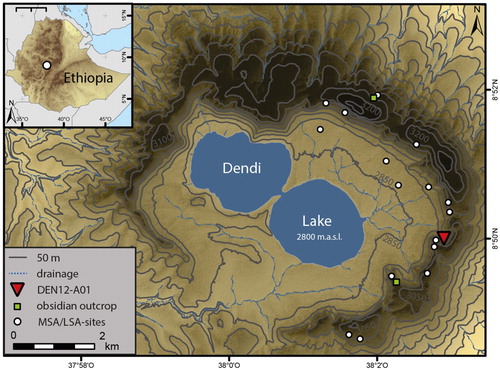
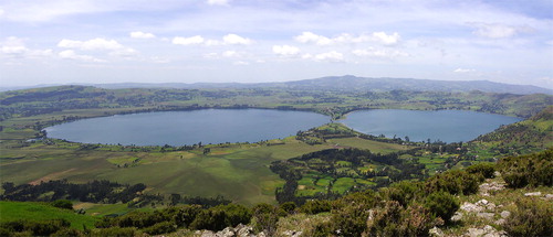
The caldera itself has an almost elliptical shape with a diameter of about 8.5 km in its longest direction and 6.5 km in its shortest. A notable feature is the presence of two lakes formed within the central depression (). A large number of springs in the steep slopes of the caldera drain into the lakes. The current abundance of water is recharged during two rainy seasons spanning from February to April and from June to September with an annual mean of about 1400 mm (Adimassu et al. Citation2014; Degefu et al. Citation2014).
Figure 2. View of the Mount Dendi caldera with the two crater lakes.
Population pressure and intensive farming have impacted Mount Dendi’s landscape to such an extent that the natural forest vegetation is only preserved in areas that are difficult to access. The potential natural vegetation is classified to the ‘dry evergreen Afromontane forest and grassland complex’, whereas that of the caldera rim above 3000 m a.s.l. belongs to the ‘Ericaceous belt’ (Friis et al. Citation2011).
Archaeological survey concomitant with coring activities in the crater lakes just mentioned was undertaken by the University of Cologne’s CRC 806 research group in April 2012 (Wagner et al. Citation2018) and led to the first discovery of Stone Age artefacts in the Dendi caldera. Of special importance is the rockshelter Dendi12-A01 (DEN12-A01). Road construction had cut the deposits in front of a steep rock face and led to the erosion of numerous obsidian artefacts that attracted the attention of the survey team. The narrow overhang is located in a large trachytic cliff of the western flank of the caldera depression at an altitude of 2987 m a.s.l. ( and ).
Figure 3. The DEN12-A01 rockshelter (yellow oval) and surrounding landscape (top). Close-up of the shelter with scale (bottom).
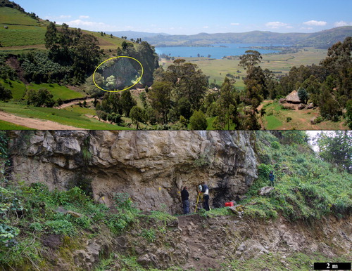
The formation of rockshelters and caves is extremely rare in the volcanic lava flows and domes and up to now DEN12-A01is the only recorded rockshelter with archaeological remains on Mt Dendi. The site’s location offers two advantages: first, it is possible to overlook the caldera and the lakes and second the rock wall offers protection from the strong winds common in the area.
Research questions
As will be shown, blades and bladelets form a major group of the débitage in all Dendi assemblages and a significant amount of them have been transformed into backed microliths. Despite the early occurrence of backed tools during Marine Isotope Stage (MIS) 4, such as the southern African Howiesons Poort industry, backed microliths have until now been considered to be a main characteristic of the African Later Stone Age (LSA) (Clark Citation1985: 95; Ambrose Citation2002; Leplongeon Citation2014: 1). Moreover, assigning DEN12-A01 to the so-called Ethiopian Transitional Industries of the Late Pleistocene (Brandt Citation1986: 62) or to the Hargesian (Clark Citation1954; Gutherz et al. Citation2014) is not possible due to the absence of Middle Stone Age (MSA) elements. The general attribution of the DEN12-A01 assemblages to the Later Stone Age is therefore obvious.
However, a detailed description of the typo-technological development of lithic assemblages is still missing for the region, partly due to political instability in the Horn of Africa and discontinuous patterns of research. Indeed, not much progress has been made toward defining clear technocomplexes for this period since the fundamental work of J.D. Clark (Citation1954) and S.A. Brandt (Citation1986). Clark (Citation1954) grouped the LSA into four lithic industries, namely the Magosian, Hargesian, Doian and Wilton, contexualising them with respect to the geology of the Horn of Africa. Brandt (Citation1986) then synthesised the following thirty years of research, including chronometric and palaeoenvironmental data. He concluded that the stone tool complexes are in need of revision and that macro-regional studies are necessary to answer questions about hunter-gatherer adaptations to environmental change in the Horn of Africa, which is characterised by a high temporal and spatial diversity. Nelson (Citation1976: 138) mentions similar conditions for technological variability in East Africa.
In the last 20 years, new research, especially by French colleagues, has significantly enhanced the available database. This has initiated new interpretations of cultural developments during the LSA (Bon et al. Citation2013; Assefa et al. Citation2014; Ménard et al. Citation2014; Pleurdeau et al. Citation2014). By giving a detailed description of the lithic artefacts from the DEN12-A01 rockshelter we want to enable high comparability with other LSA assemblages in the Horn of Africa. We thus focus here on the following three questions.
Is there a significant chronological change in technology and typology apparent in the DEN12-A01 sequence?
Are LSA sites from the southwestern Ethiopian highlands different from lowland sites in terms of their lithic assemblages?
Was the Dendi caldera a refugium for hunter-gatherer groups during arid periods?
Excavation methodology
In October 2012, a team from the University of Cologne directed by one of the authors (R. Vogelsang) excavated a test-trench measuring one square metre in the remaining sediments of the DEN12-A01 site. Most of the archaeological deposits had already been destroyed by road construction. The areas close to the back wall of the shelter and in front of the drip line, both of which are especially prone to disturbances by post-depositional processes, were avoided. The potential excavation trench was therefore restricted to a small area.
The trench was divided into quarter-metre squares and excavated in spits of 5 cm depth; spits were subdivided more finely when sediment changes in colour or texture were observed during excavation. Layers were differentiated based on those different sediments. Every spit or sub-spit was marked with a level number and every layer received a Roman number. The artificial units were used to document the spatial structure of the trench. Furthermore, they made it possible to reconstruct the position of the finds. All excavated material was sieved in three stages, using mesh widths of 10, 5 and 2.5 mm. All finds were separated according to material type (stone, pottery, bone, wood, charcoal and other botanical macro-remains) during the excavation process.
Stratigraphy
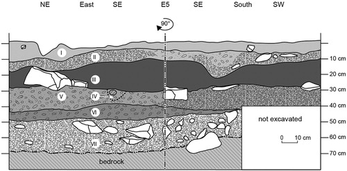
The square metre was excavated to a depth of 70 cm. This comprised 14 spits and seven layers (designated by Roman numbers). Most of the sediment units from the DEN12-A01 stratigraphy reflect a mixture of natural and anthropogenic deposition (). The only exceptions are Layer IV, which is a fluvial channel that contains only redeposited, worn artefacts, and Layers I and VII, which seem to be predominantly naturally deposited with only minor input from human activities. The extreme abundance of lithic artefacts in the middle part of the stratigraphy (Layers IV and VI) might point to a compaction of cultural material through the erosion of fine-grained natural sediments, most probably by low energy fluvial activities. Such post-depositional processes are presumably also the reason for the high portion of small gravels in Layers II and VII. Nevertheless, a well-preserved hearth structure in Layer II, the preservation of charcoal in all layers, the radiometric dates, the presence of bones down to Layer VI and the high portion of chips in the stone artefact débitage all argue against a severe disturbance of the deposits and of the settlement layers within.
Figure 4. DEN12-A01: section drawing with sediment units I to VII.
I: loose silty sediment of dark grey/brown colour mixed with organic material.
II: more compact, silty to fine-grained sediment of dark grey/brown colour mixed with numerous small gravels (0.5–5 cm).
III: ashy, greyish brown sediment with an increasing amount of small to medium sized gravels, interspersed with abundant charcoal flecks and small pieces of charcoal. A concentration of charcoal with patches of greyish-white ash indicates a hearth structure in the SE corner (not visible in the profile).
IV: fluvial channel. Very loose sediment mixed with many gravels, worn artefacts and small roots.
V: fine-grained, clayey sediment of reddish-brown colour interspersed with white calcareous rocks that are quite brittle. Some of them are relatively large (10–20 cm). Cut by a small fluvial channel (IV) in quarter-squares NW, SW and SE.
VI: clayey sediment of brown colour with a very high content of small gravels (2–5 cm) and obsidian artefacts. There are some bigger rocks (up to 10 cm) in the southern part.
VII: consolidated light brown sediment with high abundance of small gravel and big rocks. The number of obsidian artefacts decreases towards the base, where bedrock was reached.
Radiocarbon dating
A total number of eleven AMS radiocarbon dates indicate repeated occupations of the shelter at least since the mid-Holocene (; ). For calibration we used CalPal 2016.2 (Weninger Citation1986; Weninger and Jöris Citation2008) and the IntCal13 curve (Reimer et al. Citation2013). All the dates derive from charcoal, but it was not possible to securely identify the exact nature of the charcoal material present due to poor preservation conditions. Based on observations by the excavators and later assessment of datable charcoal we assume that it is wood charcoal. As a result, it is not possible to rule out the old wood effect (Schiffer Citation1986). After comparing radiocarbon dates from wood with short-lived taxa Kim et al. (Citation2019) conclude that the old wood effect does not cause significant bias before the first millennium BC and depends on different factors. Research about the old wood effect in Ethiopia might clarify the issue.
Figure 5. DEN12-A01: distribution of AMS-dates and their correlation with climatic phases. The graph was produced with CalPal 2016.2 (Weninger Citation1986; Weninger and Jöris Citation2008) using the IntCal13 calibration curve (Reimer et al. Citation2013) and climatic data from Foerster et al. (Citation2015), Trauth et al. (Citation2015) and Wagner et al. (2015).
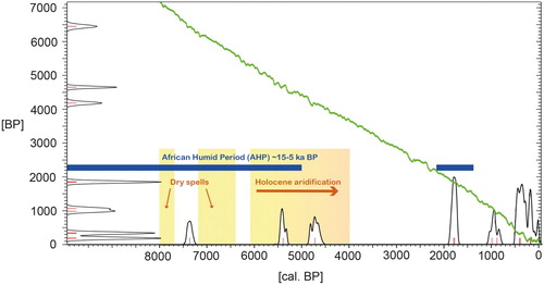
Table 1. DEN12-A01 AMS radiocarbon dates calibrated with CalPal 2016.2 and the IntCal13 Curve.
Due to the lack of any datable material, the basal levels of sediment unit VII and of archaeological horizon D within it remain undated. A single measurement of cal. AD 1505–1621 (327 ± 34 BP, COL-2017.1.1) comes from charcoal that must have fallen from the uppermost parts of the profile. However, there is a probable terminus post quem of 8200 cal. BC for the basal layers. This is the age of a 2 m-thick tephra layer revealed in a sediment record from the Dendi lakes (Wagner et al. Citation2018). Evidence of this massive eruption is missing in the rockshelter’s sediments, suggesting a later deposition of the preserved layers. This indicates that the shelter had been used since the early Holocene.
With an age of 5364–5464 cal. BC, the oldest date (6449 ± 50 BP, COL-2026.1.1), which comes from sediment unit VI, is of special interest because there is no published contemporaneous archaeological inventory from the Ethiopian Rift-Valley or the southwestern Ethiopian highlands (Foerster et al. Citation2015). This date verifies the settlement of the shelter (Archaeological Horizon C) between two drier spells of the African Humid Period (AHP). Starting around 3000 BC, increasing aridification led to the end of the AHP. Sediment unit V represents this phase and two dates of 2688–2854 cal. BC (4182 ± 43 BP, COL-2024.1.1) and 3381–3493 cal. BC (4650 ± 30 BP, Beta-481342) date the associated archaeological horizon B. A small fluvial channel within the stratigraphy from AD 170 contains only rolled, displaced artefacts. The local climate record from lake cores implies low lake level in combination with increased rainfall runoff between 650 BC and AD 450 (Wagner et al. Citation2018). Sediment unit A covers the last 900 years. The oldest date from this layer of cal. AD 1046–1144 (938 ± 34 BP, COL-2016.1.2) also dates the earliest appearance of pottery at DEN12-A01. The youngest date is cal. AD 1684–1866 (COL-2015.1.1, 183 ± 33 BP) and indicates that the site was used as a stopover until recent times.
Cultural sequence
Only the quarter-squares SE and NE were excavated down to bedrock. The stone artefact analysis therefore focused on the 10,214 lithic artefacts from these units. The exclusive raw material used for stone artefact production was obsidian. Several raw material sources are available in the surroundings of the shelter, but specific provenances have not yet been checked by electron microprobe analysis. Retouched artefacts were differentiated into five major tool categories: backed microliths, scrapers, burins, denticulates/notched pieces and undiagnostic retouched pieces.
The overall distribution and density of the stone artefacts together with the radiocarbon dates indicate several phases of human occupation that are separated by periods of abandonment. The phases can be roughly correlated with sediment units and represent, according to the distribution of the tool categories, different cultural horizons (A–D) ( and ). Flakes are defined by the existence of a ventral and a dorsal side. This is the case for blades as well. Additionally, blades are twice as long as they are wide with parallel edges and dorsal ridges. Bladelets are blades with a width smaller than 10 mm. The percentages in the following section represent complete and fragmented objects. For blades and bladelets we considered only blanks with a proximal-medial preservation in combination with aforementioned criteria.
Table 2. DEN12-A01: Distribution of débitage per archaeological horizon.
Table 3. DEN12-A01: distribution of complete cores per archaeological horizon.
Table 4. DEN12-A01: distribution of major tool types per archaeological horizon.
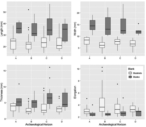
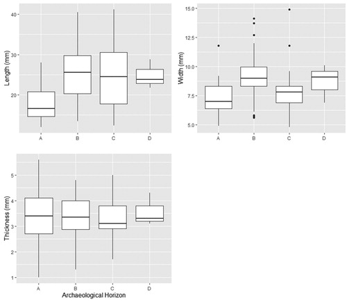
The composition of the lithic débitage () is quite similar in all the archaeological horizons and shows only slight changes in proportion. Small flakes (<25 mm) are the dominant débitage category. Their percentage varies between 50.1% and 30.9%. More pronounced is the decrease of large flakes from Horizon A (4.2%) towards the bottom Horizon D (2.0%). An opposite trend shows the distribution of bladelets with increasing portions from Horizon A (14.2%) to horizon D (19.0%). The median length, width and thickness of bladelets in Horizon A is bigger than in the other horizons, but their elongation (length divided by width) is the lowest. This means that bladelets in the lower three horizons are relatively longer (). The quantity of blades is always under 10%. Their distribution is quite constant; only Horizon C shows a significant drop. Cores are always rare (less than 1.3%). Single platform cores are present in all horizons and represent about 60.5% of all cores. In Horizon A irregular cores dominate and point to an increase in opportunistic blank production. Cores with more than one platform (double platform, opposed platform and multiple platform) are only present in Horizons B, C and D and are missing from Horizon A (). Alternating exploitation of the same face from two platforms is the exception. Additional platforms were used for new flaking surfaces or modifications.
Figure 6. DEN12-A01: size of bladelets and blades throughout the stratigraphy. The graph was produced using R (R Core Team Citation2018) and package ggplot2 (Wickham Citation2016).
A total of 2573 flakes and flake fragments smaller than 10 mm (chips) verify the production and repair of stone tools at the site. In addition, they support the aforementioned assumption that post-depositional disturbances of the settlement layers were not too excessive and restricted to low-energy fluvial processes. However, they are certainly under-represented and their distribution is therefore insignificant for any chronological differentiation.
All in all, débitage proportion and core type distribution indicate a technological change between the youngest archaeological horizon (>AD 1000) and the three older assemblages (>2000 BC).
Backed microliths are the dominant tool category. They are only absent from the surface layer and the upper part of Horizon A, which seems to represent two different settlement phases (A1 and A2), as is also indicated by the radiocarbon dates. Backed microliths are the characteristic tool category in all the other horizons, except the basal Horizon D, where undiagnostic retouched pieces predominate. Scrapers are absent in Horizons A and D and are represented by only two artefacts in Horizon B. All the other scrapers (N = 9) belong to Horizon C, where they account for 12.5% of the tool composition. Denticulates and notched pieces are present in all assemblages. Their number is especially high in Horizon A and they are the exclusive tool type in the upper part of this layer (A1). Burins are represented by single pieces in Horizons A2, B and D, but are the most common tools in Horizon C ().
In summary it is possible to distinguish the four archaeological horizons through their stone tool composition. The basal Horizon D is characterised by a restricted range of formal tools, but single backed microliths are already present. Characteristic of this oldest horizon are artefacts without diagnostic retouch. In comparison, the overlying layer C is characterised by a higher number of backed microliths, scrapers and burins. The latter are most abundant here throughout the sequence. Horizon B is characterised by the highest number of retouched tools and the broadest tool-type range of all assemblages, with backed microliths, burins, denticulates, notched pieces and scrapers. The youngest horizon can be subdivided into a lower part, A2, with a tool range dominated by notched pieces and denticulates, but where a few backed microliths and burins still occur, and an upper part, A1, with notched pieces and denticulates as the only tool category.
Typology of backed tools
The stone tool assemblages from DEN12-A01 are hallmarked by backed microliths, which are a characteristic tool type of the Later Stone Age (Ambrose Citation2002; Phillipson Citation2005: 92–94, 109, 125, 137), although LSA sites without backed microliths do exist (e.g. Leplongeon Citation2014). Due to their high standardisation and commonness, they are well suitable for intra- and extra-site comparisons. However, most single types are not appropriate as type fossils for chronological classification due to their long-lasting nature. Types that are restricted to short periods seem to be the exception. More important therefore is the composition of larger assemblages. The classification used in our analysis is based on a typology compiled by B. Gehlen and colleagues (pers. comm., 12 March 1997) from the African Research Unit at the University of Cologne. The goal of this work was to standardise different typologies used for LSA assemblages from northeast and southwest Africa (Tixier Citation1963; Close Citation1977; Richter Citation1991). Additionally, some new types were identified. This common typology should avoid misunderstandings of typological designation and thereby allow trans-regional comparisons of stone tool assemblages.
The types are mainly defined by position, morphology and method of backing. If types are differentiated by size, we used length (e.g. micro-segment and large segment) and elongation (length divided by width, e.g. for all segments and double-points). The Shapiro-Wilk test (Royston Citation1982a, Citation1982b, Citation1995) shows that in the case of length and elongation some types are normally distributed while others are not. When the number of artefacts within one group was too small for the Shapiro-Wilk test we used the Jarque-Bera test with skewness and kurtosis (Jarque and Bera Citation1987). The p-value is then computed by Monte Carlo simulation. Overall, we cannot expect normality for the two variables (length p-value = 0.003; elongation p-value = 0.0001). Due to the data not being normally distributed and the presence of multiple groups (eighteen types), differences in length and elongation are tested with the Kruskal-Wallis test (Hollander and Wolfe Citation1973). For length the p-value is equal to 0.0001 and for elongation to 0.00003. As the p-values are less than the 0.05 significance level, it is possible to conclude that there are significant differences in length and elongation between the types. To calculate comparisons between types, a pairwise two-sample permutation test with matrix output was used (Mangiafico Citation2019). The applied adjustment method for p-values by Benjamin and Yekutieli (Citation2001) controls the false discovery rate. Only sixteen pairs of types are significantly different from each other. For further statistical testing of the typology an increase of sample size is necessary. Nevertheless, taking the other attributes like retouch into account it seems feasible to use the types for the DEN12-A01 assemblage. For this data analysis R was used (R Core Team Citation2018) with the packages normtest (Gavrilov and Pusev Citation2014) and rcompanion (Mangiafico Citation2019). Backed tool types appearing in the DEN12-A01 assemblages are illustrated in and defined in .
Figure 7. DEN12-A01: backed tools typology: 1) large segment; 2) micro-segment; 3) very small segment; 4) micro-segment with crossed backing; 5) segment with curved ends; 6) backed point with oblique truncation; 7) convex backed point; 8) backed point with notch; 9) long unilaterally retouched micro-point; 10) short unilaterally retouched micro-point; 11) alternately retouched micro-point; 12) long unilaterally retouched micro-doublepoint; 13) long symmetrical bilaterally retouched micro-doublepoint; 14) elongated isosceles trapeze with straight truncation; 15) segment-like isosceles trapeze with convex truncation; 16) isosceles triangle; 17) backed bladelet; 18) (broken) backed blade.
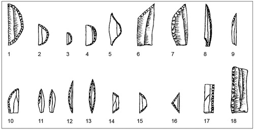
Table 5. DEN12-A01 backed tool-types and their definition.
Backed microliths as chronological markers
With 239 artefacts (used pieces not included), backed microliths represent 35.6% of the total number of tools in the Dendi assemblage and the major tool category present. Due to their large number and their relevance for the Holocene LSA, this section focuses on their different types and their occurrence in the different archaeological horizons ().
Table 6. DEN12-A01: distribution of backed microliths per archaeological horizon.
Segments
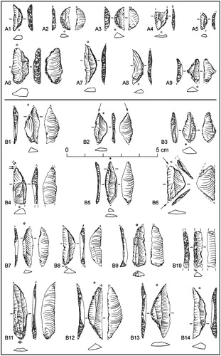
Segments (: 1–5) account for 11.8% of all the microlithic tools present. With five sub-types they are the most heterogeneous group. Most pieces are complete (80%) and their assignment is therefore unambiguous. Only one segment from Horizon A exceeds 25 mm in length. There are nine micro-segments, of which one has crossed backing, one has curved ends and one is very small (: A5). With the exception of the extraordinary piece with the curved end (: B2) and one simple micro-segment from Horizon B, all the other pieces belong to Horizon A2. They are therefore characteristic of the younger settlement phases of the rockshelter.
Figure 8. DEN12-A01: backed microliths from Horizons A and B: micro-segments (A1, A2, A4); micro-segment with crossed backing (A3); very small segment (A5); large segment (A6); long micro-double-points, unilaterally retouched (A7, A8, B5, B12, B14); isosceles triangles (A9, B6, B13); elongated trapezes, isosceles with straight truncation (B1, B11, B8); segment with curved end (B2); alternately, bilaterally retouched micro-point (B3); long micro-points, unilaterally retouched (B4, B7, B9); (broken) backed blade (B10).
Micro-points
Micro-points (: 8–13) represent 61.2% of all the microliths at Dendi. Their high number might partly be due to the fact that nearly all (69.2%) are broken. The high fragmentation of this tool type also complicates their identification and definite classification to one of the possible sub-types. In all, 21.2% of the micro-points could not be classified to a specific sub-type. The majority of the distinct pieces are long, unilaterally retouched micro-points, followed by double-points. With the exception of one symmetrical, bilaterally retouched double-point and one alternately, bilaterally retouched micro-point, all the remaining 50 pieces are only retouched on one edge. Less common are short micro-points.
Almost all micro-points with a distinct designation can be assigned to Horizon B and they are therefore a type-fossil for this period. The only exceptions are double-points, which occur in all the archaeological horizons. However, their main distribution is in Horizon C, where their percentage exceeds that of the long micro-points. Double-points from Horizon C are, in general, slightly longer and more elongated than in Horizon B ().
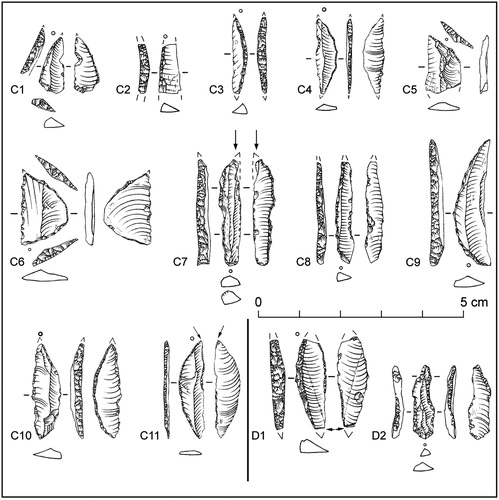
Figure 9. DEN12-A01: backed microliths from Horizons C and D: long micro-point, unilaterally retouched (C1, C5, D2); backed bladelet (C2); long micro-double-point, unilaterally retouched (C3, C4, C9, C10, C11, D1); segment-like trapeze, isosceles with convex truncation (C6); backed point with notch (C7, C8).
Trapezes
Trapezes (: 14–15) are a small but highly variable group. Besides three elongated trapezes and one segment-like piece, one did not fit into any of these groups. Four of five trapezes belong to Horizon B, while the only segment-like trapeze is from Horizon C.
Triangles
Triangles (: 16) form the smallest and most homogenous group of microlithic tools. All three pieces are isosceles triangles. Like the segments, they occur in Horizons A2 and B. The single piece from Horizon A2 (: A9) is smaller and thicker than the two pieces from Horizon B (: B6 and B13). Like the very small segment from the same assemblage, this might point to a chronological trend of miniaturisation in the younger assemblage.
Backed bladelets
Backed bladelets (: 17) occur in all horizons, but mainly in Horizons A2 and B. However, some of these pieces may be fragments of other microlithic tool-types and thus not have been intentionally produced. Their chronological informative value is therefore low.
Backed blades
Backed blades (: 18) from Horizons B and C might, as in the case of the backed bladelets, be fragments of other tool-types, for example, of backed points. Due to their dimensions (>2.5 cm), they are not microliths in the narrow sense, but are closely related by reason of their backed retouch.
Backed points
This is also true of backed points (: 6–7), which are likewise longer than 2.5 cm. With the exception of a convex backed point from Horizon B, two backed points with notches and one backed point with oblique retouch all come from Horizon C.
To sum up, the oldest horizon, Horizon D, is characterised by the rarity of any formal tools. However, two micro-points and a backed bladelet verify the production of microlithic backed tools already at this early stage of the site’s history. Backed microliths, especially double micro-points but also one trapeze, are a common element of Horizon C, but non-microlithic tool types, such as scrapers, burins and large backed points, play a more prominent role. The largest number of microlithic tools occurs in Horizon B, dating to between 3381–3493 and 2688–2854 cal. BC. This horizon also sees the greatest range in backed microlith types (segments, triangles, trapezes and, in particular, different forms of micro-points) and is separated by a hiatus of 3000 years from the overlying horizon, Horizon A. Backed microliths are restricted to a few segments in Horizon A2 and are absent in Horizon A1 above this.
Although our analysis of the dimensions of backed microliths as a chronological marker was hampered by the low number of complete pieces and our results are not therefore statistically solid, as a general impression backed microliths from Horizon A are shorter than those from the lower three horizons ().
Figure 10. DEN12-A01: length, width and thickness of all backed microliths. The graph was produced using R (R Core Team Citation2018) and package ggplot2 (Wickham Citation2016).
Core reduction
Despite the presence of outcrops in the vicinity of the site raw material was used economically in all the assemblages at DEN12-A01. Cores were knapped until it was impossible to maintain convexities. Opportunistic reduction is present throughout the sequence, either on irregular pieces of raw material without further modification or on otherwise finished cores in order to obtain one last flake.
Core preparation started in all cases with the removal of cortex. In the case of cores with one flaking surface, the adjacent faces could be fully cortical at an early stage. The back side opposed to the flaking surface is usually unprepared. Core exploitation focused on the production of bladelets in all horizons as shown by the elongated negatives on both cores and blanks. The flaking surface is convex. Convexity was maintained by overshots, preparation flakes opposed to the main flaking direction, preparations perpendicular to the flaking surface or blanks struck from the core edge. Core tablets, blanks from the edge of the platform and flakes for preparing the core flanks are signs of further core rejuvenation between knapping sequences.
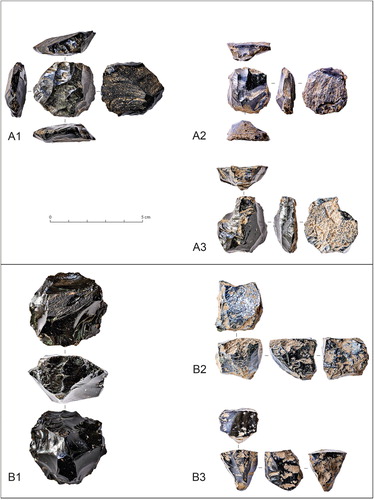
In Horizon A, cores have similar lengths and widths are not as thick. This resulted in flat, rounded artefacts. The platform was prepared laterally and blanks detached unidirectionally. A second platform was prepared opposite to the other for modifications of the flaking surface. The other side of the core remained cortical. The cross section is plano-convex ().
Figure 11. DEN12-A01: cores from Horizons A and B: all of the same concept (A1–A3); second concept of the three lower horizons (B1); third concept of the three lower horizons (B2, B3).
In the three lower archaeological horizons, three concepts of core reduction are present. In the first concept, cores have two sides, one flaking surface and one striking platform surface. The latter was prepared with centripetal flaking. These negatives were then used as platforms for flaking the other side. When the flaking surface was used up, the core was discarded. The main flaking direction was unidirectional with modifications from other directions. The flaking surface was less convex than the striking platform face, which resulted in plano-convex cores.
The cores of the second concept were prepared in a centripetal way and were plano-convex as well. The relatively flat side was used as a platform and bladelets were detached along the ridges of the centripetal flaking. A unidirectional, convergent configuration was used. After one flaking surface was finished, another was started. This resulted in circumferential cores, but the circumference was not knapped in one sequence ().
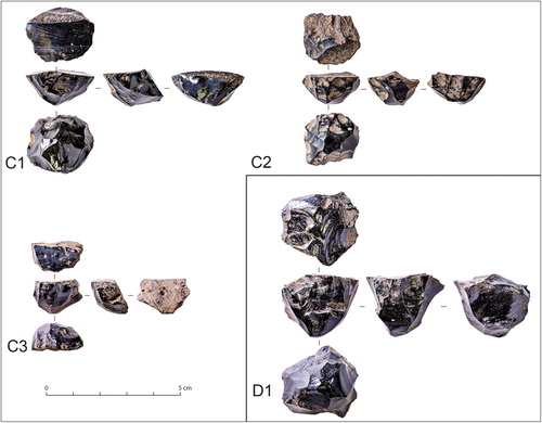
The third concept encompasses a wide range of different core types, all of them with one primary platform and, in some cases, an opposed secondary one for modifications. The types are cores with one unidirectional parallel flaking surface, adjacent flanks and an unprepared back or semi-circumferential cores with one flank and an unprepared back. Cores with mixtures between these patterns show that they are all part of one continuous reduction. They are polyhedrons with a variable number of faces. The backsides and bases were usually unmodified at the beginning. In some cases the flaking surface extends towards the flanks in later stages. The result was to produce cores with a convex flaking surface and an unmodified backside rectangular to the platform ().
Figure 12. DEN12-A01: cores from Horizons C and D: third concept of the three lower horizons (all).
Pottery
Thirteen potsherds were found in the uppermost layers of the rockshelter (Horizons A1 and A2). Two fragments in Horizon B have the same temper and colour as the sherds in A; we assume that they were moved by bioturbation. Two pieces are fragments of a rounded rim, while others are from the body. No decoration is visible and the sherds are always sand-tempered. Core colour is mostly brown or light red, but in one case white. Red slip was applied to the inner and outer surfaces and its use is also reported from Mota and Tuwatey Caves in the Gamo Highlands of southwestern Ethiopia (Arthur et al. Citation2019).
The oldest date in association with pottery from DEN12-A01 of cal. AD 1046–1144 is in accordance with others for the late appearance of ceramics in other highland regions, for example at Kafa (Hildebrand and Brandt Citation2010), Mochena Borago (Gutherz et al. Citation2002) and Sodicho (pers. obs.), making it significantly later than in the northern lowlands of the country. The low number of pottery sherds, even in the youngest layers, might be an indication for the ephemeral use of the shelter for short-term stays rather than as a base-camp for long-term occupations.
Faunal remains
A total of 658 faunal remains were found during the excavations. Due to high fragmentation and heavy soil corrosion, only 107 bones and one tooth fragment could be identified (). Most of these remains (N = 80) come from Horizon A and include a large number of rodent bones, which are better preserved than the other faunal remains. This may suggest a recent intrusion not linked with anthropogenic activities. The rest of the fauna from this horizon includes mainly wild bovids, especially three fragments from Antilopini and one tooth fragment probably coming from a Cape buffalo (Syncerus caffer). We also notice the presence of one primate bone (from a small cercopithecid) and nine fragments of rock hyrax (Procavia capensis). The older horizons (Horizons B, C and D) delivered only six, ten and one identified remains respectively, mainly of bovids. Horizon C also produced a single fragment of warthog (Phacochoerus sp.).
Table 7. DEN12-A01: faunal remains (NISP).
The few species that could be identified can all live in the Afromontane forest and grassland that was present in the vicinity of the site. The assemblages from the different horizons are too small, however, to be indicative of the climatic changes that occurred during the Holocene. The only noteworthy result is the absence of domesticates through the entire sequence, even during the very recent occupations of the site. Although difficult to assert with such small collection, this fits with the hypothesis of a very late introduction of domesticates in the highlands, at least in communities of settled farmers (Lesur et al. Citation2014).
Discussion
A comparison with other Holocene hunter-gatherer assemblages from the Horn of Africa might clarify whether the changes in the range of tool types in the assemblages from DEN12-A01 reflect a local development or if they are representative of a regional trend. For this purpose, we use the tripartite division of the Holocene into ‘early’, ‘middle’ or ‘mid-’ and ‘late’ as chronological stages. While the beginning of the Holocene is dated to 9700 cal. BC (Walker et al. Citation2009), we follow Walker et al. (Citation2014) and Cohen et al. (Citation2013) in using the 8.2 ka event (6200 BC) as the early to middle Holocene boundary and the 4.2 ka event (2200 BC) for the middle to late Holocene boundary (which is, however, still contested; see Voosen Citation2018). Unfortunately the number of well-dated sites is very small, many assemblages come from old excavations and the material has not been studied in detail or well published. The first part of the discussion compares the temporal and environmental context of DEN12-A01 with other sites from the Horn of Africa.
The oldest assemblage from DEN12-A01 — that from Horizon D — is undated, but there are indications that it dates to the early Holocene. Comparable inventories are rare in the Horn of Africa and seem to represent a phase of re-settlement after the arid phase of the Younger Dryas stadial (Foerster et al. Citation2015). This arid interruption of the African Humid Period (AHP) separates late Pleistocene from early Holocene assemblages. Regionally, they concentrate in the Ziway-Shalla Basin in Ethiopia, with sites like Deka Wede DW2s1 and DW2s2 (Bon et al. Citation2013; Ménard et al. Citation2014), Deka Wede B20 (Street Citation1979) and Macho Hill (Haynes and Haas Citation1974). Occupations along the lake margins just before the last main transgression are a common feature of both these sites and the DEN12-A01 rockshelter. Attachment to an aquatic environment is not so obvious at other Ethiopian sites from this period, such as Aladi Springs (Williams et al. Citation1977; Gossa et al. Citation2012), Laga Oda (Kurashina Citation1978: 446) and Baahti Nebait (Finneran Citation2001). However, the first site was a mound spring (Clark and Williams Citation1978), the second is located close to fresh water sources (Cervicek Citation1971) and the latter rockshelter is linked to seasonal watercourses (Finneran Citation2000). In Somalia, other sites, like the complex of Laas Geel, are situated in the vicinity of wadis (Gutherz et al. Citation2014) or, as with the Rifle Range Site (Jones et al. Citation2018) and Gogoshiis Qabe (Brandt Citation1988), are at inselbergs that provide favourable ecological conditions due to their increased water catchment (Jones et al. Citation2018 after Jürgens and Burke Citation2000; Porembski and Barthlott Citation2000; Burke Citation2003; Müller Citation2007).
The mid-Holocene, which in general was a relatively humid phase in the Horn of Africa, is marked by a slight increase in the number of dated archaeological sites (early Holocene nine sites; mid-Holocene 15 sites; after Ménard Citation2015: ). With the inventories from Horizons C and B, DEN12-A01 includes one assemblage from the beginning and one from the end of this period.
Contemporaneous assemblages for Horizon C include the LSA inventory from the upper dark clay layer at K’one (Williamson et al. Citation1977), the ‘Bardaale’ Industry from Gogoshiis Qabe in Somalia (Brandt 1977) and Goda Buticha Layer IIC in southeastern Ethiopia (Pleurdeau et al. Citation2014). K’one is a complex of calderas too, while the other sites are rockshelters. All resemble the environmental context of Dendi.
The most important comparative inventory for Horizon B comes from the rockshelter of Mochena Borago in the southwestern Ethiopian highlands, which is situated on the slopes of Mount Damota (Ménard Citation2015). This inactive volcano is visible from the entrance to Sodicho Cave, another site with the same environmental context (Hensel et al. Citation2019). Further sites in the region are Mota, Tuwatey and Gulo Cave (Arthur et al. Citation2019). Their assemblages date from the middle and late Holocene. Of the same age and character are most probably different sites from Lake Besaka with younger assemblages of the Besaka Industry grouped under the term ‘Abadir phase’ (e.g. FeJx2 and FeJx2 East; Brandt Citation1982). Furthermore, during the end of the mid-Holocene, humans added pottery to their material culture. An example of this in Ethiopia is K’urk’umu (Fernández et al. Citation2007). While food-producing societies settled in large parts of the Horn of Africa in late Holocene times, the highlands of Ethiopia seem to have offered a retreat for hunter-gatherer-groups. Dendi12-A01 Horizon A represents the last millennium of this phenomenon. Even the Ziway-Shalla Basin sites are close together but very variable in means of lithic typology and technology (Ménard et al. Citation2014). Therefore, it comes as no surprise that the inventories we have mentioned from the Horn of Africa with their diverse environmental settings do not form homogenous groups.
Although southern Africa is not the geographical focus of this paper it should be mentioned that there the uKhahlamba-Drakensberg Escarpment and Maloti-Drakensberg Mountains offered similar conditions to foragers as the Ethiopian highlands. One example of a dynamic change of subsistence strategies in that region comes from the open-air site Likoaeng in Lesotho (Mitchell et al. Citation2011). Lodder et al. (Citation2018) show that the environment of Cathedral Peak remained relatively stable in the last 5000 years, suggesting that high altitude areas could have served as refugia. For the Maloti-Drakensberg region a synthesis of palaeoclimatic and palaeoenvironmental data also suggests that it was a refugium for humans during unstable, arid periods (Stewart and Mitchell Citation2018). For the Dendi caldera, climatic data from the local lake cores point towards a similar scenario (; Wagner et al. 2015).
The second part of our discussion compares the lithic typology and technology of DEN12-A01 with other assemblages from the Horn of Africa. As a tentative impression, it seems that backed microliths were an element of most assemblages since the beginning of the early Holocene, mainly in the shape of pieces classified by us as micro-points. From this time Laas Geel is the only site in the region with numerous segments. However, the radiocarbon dates here derive from ostrich eggshell and are problematic as mentioned by Gutherz et al. (Citation2014). Apart from that, geometric microliths seem to be a feature of mid-Holocene assemblages.
Micro-points form a common component of the assemblage from DEN12-A01’s Horizon C, but they are outnumbered by larger tools, such as scrapers and burins. A new feature is the first occurrence of geometric microliths, although they are only documented by a single trapeze. The mid-Holocene inventory from Layer IIC at Goda Buticha in southeastern Ethiopia dates to the same period (Pleurdeau et al. Citation2014). Comparable to DEN12-A01 is the dominance of larger tools in proportion to backed microliths, which are represented by curved backed microliths (Leplongeon Citation2014). Two differences are the occurrence of ‘typical’ MSA elements at Goda Buticha, namely facially retouched points and a significant blade component. K’one (Williamson et al. Citation1977) and the ‘Bardaale’ Industry from Gogoshiis Qabe Rockshelter in Somalia (Brandt Citation1988) are not, however, adequately published for further comparison.
Representing the younger part of the mid-Holocene, Horizon B at DEN12-A01 is characterised by a broad type range and numerous non-geometric and geometric backed microliths. The inventory from Mochena Borago (Ménard Citation2015) is likewise dominated by segments, in particular, as well as by some other geometric types. The same is true for the lithic artefacts from Sodicho Cave (pers. obs.), although its analysis is still in progress. Again, at all three sites it was mainly obsidian that people used. In addition, assemblages from the Abadir phase of the Besaka Industry are absolutely dominated by segments and already contain pottery (Brandt Citation1982). According to Leplongeon (Citation2014), curved backed microliths that might be segments are also found in the ashy layers at Goda Buticha and this whole unit could be comparable to the later phases from Besaka. The lower levels from the site of K’urk’umu, situated in the Central Ethiopian Escarpment close to the Sudanese border, date to the same period and prove the advance of Sudanese pottery in the region (Fernández et al. Citation2007). The rarity of backed tools in this assemblage (a single segment) might be due to the use of ‘poor-quality quartz’ (Fernández et al. Citation2007: 107) as the predominant raw material. Despite our focus on hunter-gatherer sites, it is nevertheless interesting to note that contemporary Neolithic sites, such as Wakrita (Gutherz et al. Citation2015) and Asa Koma (Gutherz Citation2017) in Djibouti, are also dominated by segments in their tool-type range. To sum up, the dominance of segments seems to be the common feature of most assemblages dating to the younger phase of the mid-Holocene. The earliest occupation of Mota Cave starts at 2570 cal. BC and lasts until 1390 cal. BC. The use of unifacial points sets it apart from Dendi. Similar, however, is the presence of geometric microliths, among them crescents, trapezoids and triangles. At both sites blades and bladelets are part of the débitage. The cores are at least morphologically similar and a technological similarity is possible. The assemblages also share a preference for obsidian (Arthur et al. Citation2019). Although activities were limited at Tuwatey Cave (3570 cal. BC – cal. AD 1650), the use of geometric microliths and obsidian as the raw material employed are the same. In addition, Arthur et al. (Citation2019) mention similar features for Gulo Cave (3430 cal. BC – cal. AD 260).
In the late Holocene of Dendi, backed microliths became much less important and quite unstandardised tool types, such as denticulates and notched pieces, characterise the tool range found. This is in contrast to the contemporaneous assemblages from Ajilak 6 (González-Ruibal et al. Citation2014) and Akirsa (Bouakaze and Poisblaud Citation2000 as quoted in Ménard Citation2015: 155, Figure 86) that include larger numbers of different types of geometric microliths. Mota and Tuwatey Cave is an example from the Ethiopian highlands with geometric microliths in use until cal. AD 1650. At the same time humans consumed domesticated plants and animals (Arthur et al. Citation2019). In the Dendi Lake Rockshelter, there is no evidence for domestication. The low number of formal tools in Horizon A from DEN12-A01 is comparable to the younger layers of Bel K’urk’umu (Fernández et al. Citation2007) and some of the younger sites in the highlands of Kaffa (Hildebrand and Brandt Citation2010; Hildebrand et al. Citation2010).
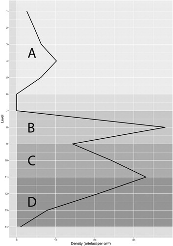
Besides the chronological indication of formal tool types, their range can also be task-specific (Laplace Citation1972; Odell Citation1981). It seems plausible that different stone tool categories are linked to different activities. In this sense, inventories with a single primary tool class represent a specific activity range and are also likely to indicate a shorter duration of stay. Complicating issues here, however, are that a single type could have served several tasks or that different types might have been used for the same activity (Odell Citation1981). Use wear analysis could solve this problem. With the exception of the youngest and the oldest horizons, i.e. Horizons A1 and D, all the archaeological phases at DEN12-A01 are characterised by a similar tool type range, one that is dominated by backed microliths, especially micro-points and segments. Such assemblages are representative of typical hunting equipment (Lombard Citation2008; Lombard and Pargeter Citation2008; Mazzucco et al. Citation2012). We presume that the DEN12-A01 rockshelter was never a long-term settlement site, but rather a hunting camp used by a small group of hunters for repeated short-term stays ().
Figure 13. DEN12-A01: artefact density (artefacts per cm³) per excavation level. Capital letters refer to Horizons. The graph was produced using R (R Core Team Citation2018) and package ggplot2 (Wickham Citation2016).
Conclusion
The DEN12-A01 rockshelter shows evidence of repeated habitation in a high-altitude region since the (later) early Holocene. To answer the first research question that we posed above, the four archaeological horizons that we differentiated show distinct characteristics in their stone artefact inventories. Stone tools were used until recent times, but, with the exception of notched pieces and denticulates, formal retouched tools are absent in the uppermost horizon, Horizon A1. Segments are characteristic of Horizon A2, which has an age of about cal. AD 1095. These youngest settlement phases are separated by a hiatus of 3000 years from the underlying occupations. Charcoal dating to around cal. AD 170 from a fluvial channel indicates erosional activities around that time, which may have destroyed archaeological evidences from the intermediate period (2000–1 BC). Horizon B has the broadest range of backed microliths with segments, triangles, trapezes and micro-points. The latter, in particular, characterise the approximately 3000 cal. BC assemblage. The only exceptions are double-micro-points, which are typical of the underlying layer, Horizon C. The relatively high occurrence of burins and fewer scrapers besides backed tools in Horizon C might be a chronological marker or an indication of a broader activity range. The basal, and, up to now, undated, Horizon D is characterised by the virtual absence of formal tools, but has a high number of flakes and bladelets with edge damage that might be use-wear. These patterns are not applicable to a bigger geographical scale.
While a lack of backed microliths is no reason to exclude a site from the Later Stone Age, their presence in combination with blade production is an indicator for the LSA. Geometric backed microliths are abundant within Holocene LSA assemblages. In the Pleistocene Later Stone Age, they are not present. These changes might be valid for the Horn of Africa, but the database is still too weak for well-grounded conclusions.
The comparison with other stone tool assemblages shows a high inter- and intra-site variability throughout the Holocene. Concerning our second research question, characteristics specific to the highlands are not visible in terms of the lithic artefacts found. The restricted range of tool types with an emphasis on micro-points and segments nevertheless points to short-term stays by small groups of hunters, as is also suggested by the fact that only wild species are present among the faunal remains recovered. Hunting trips might have been combined with other activities, such as the procurement of obsidian. Collecting honey and plants is also at least conceivable. In this way, foragers would have exploited a wide range of resources by taking advantage of different nearby altitudinal ecozones. A corresponding pattern has been proposed for Mount Damota, located in the southwestern highlands of Ethiopia (Vogelsang and Wendt Citation2018). In terms of animal exploitation, herding seems to have reached this area very late, as has already been highlighted in Kaffa and Wolayta, areas where the incorporation of livestock and ceramic production took place in longstanding and highly conservative systems (Lesur et al. Citation2014).
Finally, the correlation of the settlement phases with palaeoclimatic data for Ethiopia (Foerster et al. Citation2015; Trauth et al. Citation2015) verifies human presence at Mount Dendi during the phase of aridification at the end of the African Human Period. Climatic evidence from two cores from the Dendi crater lakes shows that the effect of this climatic deterioration seems to have been less distinct on the local scale (Wagner et al. Citation2018). Considering our third research question, this therefore implies that the Dendi caldera was indeed a refugium. It would be interesting to check if this is a special case or more broadly characteristic of high-altitude areas in the region. A new Ethiopian-European research project ‘The mountain exile hypothesis — How humans benefited from and re-shaped African high-altitude ecosystems during Quaternary climate changes’ (DFG FOR 2358) is currently dealing with this question using the example of the Bale Mountains (Reber et al. Citation2018).
Acknowledgements
We thank the local residents of Mt Dendi for their support and participation in field research. The Ethiopian Authority for Research and Conservation of Cultural Heritage (ARCCH) and regional and zonal cultural bureaus facilitated fieldwork and museum studies. We are very thankful for all the help they provided. We also thank all participants of the fieldwork, which had to withstand the sometimes-harsh environmental conditions. We want to express our particular gratitude to Prof. Juergen Richter, who gave useful advice and critiques during the analysis and afterwards, Dr Tamrat Endale for his support during the fieldwork, Ingrid Koch for the lithic drawings, Lutz Hermsdorf-Knauth for help with the figures and Taylor Otto for proofreading. We are grateful to the University of Cologne for administrative support, especially Dr Werner Schuck from the office of the CRC 806. Our grateful thanks are extended to Behailu Habte for constructive discussion of the LSA. Special thanks to Dr Georg Roth for his helpful workshop about R. We thank the two anonymous reviewers who provided constructive criticism to help us improve this article. This project is affiliated to the CRC 806 ‘Our Way to Europe’ funded by the Deutsche Forschungsgemeinschaft (DFG, German Research Foundation) Project-ID: 5744011 - SFB 806.
Notes on contributors
Ralf Vogelsang (Ph.D. 1993, University of Cologne) is a senior researcher at the Palaeolithic Research Unit (FAST) and principal investigator for the Collaborative Research Centre 806 ‘Our Way to Europe’ at the Institute of Prehistoric Archaeology, University of Cologne. His research focuses on African archaeology. Currently he is working on modern human dispersal out of Africa and the role of high-altitude ecosystems as possible refugia.
Joséphine Lesur (Ph.D. 2004, University of Paris 1 Panthéon-Sorbonne) is an archaeozoologist and lecturer at the Muséum National d’Histoire Naturelle in Paris. Her research focuses on the beginning of herding and its patterns of diffusion, as well as on the exploitation of animal diversity during the Holocene in northeastern Africa (the Horn of Africa and Egypt) and Namibia.
Christian Schepers is a PhD Candidate in the Collaborative Research Center 806 ‘Our Way to Europe’ at the Institute of Prehistoric Archaeology, University of Cologne. Currently he works on the dispersal of modern humans in Ethiopia and Egypt.
References
- Abbate, E., Bruni, P. and Sagri, M. 2015. “Geology of Ethiopia: a review and geomorphological perspectives.” In Landscapes and Landforms of Ethiopia: World Geomorphological Landscapes, edited by P. Billi, 33–64. Dordrecht: Springer.
- Abebe, T., Mazzarini, F., Innocenti, F. and Manetti, P. 1998. “The Yerer-Tullu Wellel volcanotectonic lineament: a transtensional structure in central Ethiopia and the associated magmatic activity.” Journal of African Earth Sciences 26: 135–150. doi: 10.1016/S0899-5362(97)00141-3
- Adimassu, Z., Mekonnen, K., Yirga, C. and Kessler, A. 2014. “Effect of soil bunds on runoff, soil and nutrient losses, and crop yield in the central highlands of Ethiopia.” Land Degradation & Development 25: 554–564. doi: 10.1002/ldr.2182
- Ambrose, S.H. 2002. “Small things remembered: origins of early microlithic industries in sub-Saharan Africa.” Archaeological Papers of the American Anthropological Association 12: 9–29. doi: 10.1525/ap3a.2002.12.1.9
- Arthur, J.W., Curtis, M.C., Arthur, K. J. W., Coltori, M., Pieruccini, P., Lesur, J., Fuller, D., Lucas, L., Conyers, L., Stock, J., Stretton, S. and Tykot, R.H. 2019. “The transition from hunting-gathering to food production in the Gamo Highlands of southern Ethiopia.” African Archaeological Review 36: 5–65. doi: 10.1007/s10437-018-09322-w
- Assefa, Z., Pleurdeau, D., Duquesnoy, F., Hovers, E., Pearson, O., Asrat, A., T/Tsion, C. and Lam, Y.M. 2014. “Survey and explorations of caves in southeastern Ethiopia: Middle Stone Age and Later Stone Age archaeology and Holocene rock art.” Quaternary International 143: 136–147. doi: 10.1016/j.quaint.2013.07.132
- Benjamin, Y. and Yekutieli, D. 2001. “The control of the false discovery rate in multiple testing under dependency.” Annals of Statistics 29: 1165–1188. doi: 10.1214/aos/1013699998
- Bon, F., Dessie A., Bruxelles L., Daussy A., Douze K., Fauvelle-Aymar F.-X., Khalidi L., Lesur J., Ménard C., Marder O., Mensan R. and Saint-Sever G. 2013. “Prehistory of the central main Ethiopian Rift (Ziway-Shala basin): establishing the Late Stone Age sequence in eastern Africa.” Annales d'Ethiopie 28: 405–407. doi: 10.3406/ethio.2013.1552
- Bouakaze, D. and Poisblaud, B. 2000. Néolithique et Art Rupestre dans le Wolayta (Éthiopie). Unpublished report.
- Brandt, S.A. 1982. “A late Quaternary cultural/environmental sequence from Lake Besaka, southern Afar, Ethiopia.” PhD diss., University of California, Berkeley.
- Brandt, S.A. 1986. “The Upper Pleistocene and early Holocene prehistory of the Horn of Africa.” African Archaeological Review 4: 41–82. doi: 10.1007/BF01117035
- Brandt, S.A. 1988. “Early Holocene mortuary practices and hunter-gatherer adaptations in southern Somalia.” World Archaeology 20: 40–56. doi: 10.1080/00438243.1988.9980055
- Burke, A. 2003. “Inselbergs in a changing world: global trends.” Diversity and Distributions 9: 375–383. doi: 10.1046/j.1472-4642.2003.00035.x
- Cervicek, P. 1971. “Rock paintings of Laga Oda (Ethiopia).” Paideuma 17: 121–136.
- Clark, J.D. 1954. The Prehistoric Cultures of the Horn of Africa: An Analysis of the Stone Age Cultural and Climatic Succession in the Somaliland and Eastern Parts of Abyssinia. Cambridge: Cambridge University Press
- Clark, J.D. 1985. “The microlithic industries of Africa: their antiquity and possible economic implications.” In: Recent Advances in Indo-Pacific Prehistory, edited by V.N. Misra and P.S. Bellwood, 95–103. Leiden: Brill.
- Clark, J.D. and Williams, M.A.J. 1978. “Recent archaeological research in southeastern Ethiopia. 1974–1975.” Annales d’Ethiopie 11: 19–44. doi: 10.3406/ethio.1978.902
- Close, A.E. 1977. The Identification of Style in Lithic Artefacts from North East Africa. Cairo: Geological Survey of Egypt.
- Cohen, K.M., Harper, D.A.T., Gibbard P.L. and Fan, J.-X. 2013 “The ICS International Chronostratigraphy Chart.” Episodes 36: 199–204. doi: 10.18814/epiiugs/2013/v36i3/002
- Degefu, F., Herzig, A., Jirsa, F. and Schagerl, M. 2014. “First limnological records of highly threatened tropical high-mountain crater lakes in Ethiopia.” Tropical Conservation Science 7: 365–381. doi: 10.1177/194008291400700302
- Fernández, V.M., de la Torre, I., Luque, L., González-Rubial, A. and Lopez-Saez, J.A. 2007. “A Late Stone Age sequence from west Ethiopia: the sites of K'aaba and Bel K'urk'umu (Assosa, Benishangul-Gumuz Regional State).” Journal of African Archaeology 5: 91–126. doi: 10.3213/1612-1651-10087
- Finneran, N., Boardman, S. and Cain, C. 2000. “Excavations at the Late Stone Age site of Baahti Nebait, Aksum, northern Ethiopia, 1997.” Azania 35: 53–73. doi: 10.1080/00672700009511596
- Finneran, N. 2001. “The Aksum long-blades: a late Pleistocene/early Holocene (Mode 4) lithic industry from northern Ethiopia.” Nyame Akuma 55: 23–31.
- Foerster, V., Vogelsang, R., Junginger, R.A., Asfawossen, A., Lamb, H.F., Schaebitz, F. and Trauth, M. 2015. “Environmental change and human occupation of southern Ethiopia and northern Kenya during the last 20,000 years.” Quaternary Science Review 129: 333–340. doi: 10.1016/j.quascirev.2015.10.026
- Friis, I., Demissew, S. and van Breugel, P. 2011. Atlas of the Potential Vegetation of Ethiopia. Addis Ababa: Addis Ababa University Press.
- Gavrilov, I. and Pusev, R. 2014. “Normtest: tests for normality.” R package version 1.1. https://CRAN.R-project.org/package=normtest/. Site accessed 26 November, 2019.
- González-Ruibal, A., Marin Suárez, C., Sánchez-Elipe, M., Lesur, J. and Martinez Barrio, C. 2014. “Late hunters of western Ethiopia: the sites of Ajilak (Gambela), c. AD 1000–1200.” Azania: Archaeological Research in Africa 49: 64–101 doi: 10.1080/0067270X.2013.866843
- Gossa, T., Sahle, Y. and Negash, A. 2012. “A reassessment of the Middle and Later Stone Age lithic assemblages from Aladi Springs, southern Afar Rift, Ethiopia.” Azania: Archaeological Research in Africa 47: 210–222. doi: 10.1080/0067270X.2012.676314
- Gutherz, X. (ed.). 2017. Asa Koma, Site Néolithique dans le Bassin du Gobaad (République de Djibouti). Montpellier: Presses Universitaires de la Méditerranée.
- Gutherz, X., Diaz, A., Ménard, C., Bon, F., Douze, K., Léa, V., Lesur, J. and Sordoillet, D. 2014. “The Hargeisan revisited: lithic industries from shelter 7 of Laas Geel, Somaliland and the transition between the Middle and Late Stone Age in the Horn of Africa.” Quaternary International 343: 69–84. doi: 10.1016/j.quaint.2014.04.038
- Gutherz, X., Jallot, L., Lesur, J., Pouzolles, G. and Sordoillet, D. 2002. “Les fouilles de l’abri sous-roche de Moche Borago.” Annales d’Ethiopie 18: 181–190. doi: 10.3406/ethio.2002.1019
- Gutherz, X., Lesur, J., Cauliez, J., Charpentier, V., Diaz, A., Ismaël, M.A., Pène, J.-P., Sordoillet, D. and Zazzo, A. 2015. “New insights on the first Neolithic societies in the Horn of Africa: the site of Wakrita, Djibouti.” Journal of Field Archaeology 40: 55–68. doi: 10.1179/0093469014Z.000000000110
- Haynes, V. and Haas, H. 1974. “Southern Methodist University radiocarbon date list I.” Radiocarbon 16: 368–380. doi: 10.1017/S003382220005966X
- Hensel, E.A., Bödeker, O., Bubenzer, O., and Vogelsang, R. 2019. “Combining geomorphological–hydrological analyses and the location of settlement and raw material sites — a case study on understanding prehistoric human settlement activity in the southwestern Ethiopian Highlands.” E&G Quaternary Sciences Journal 68: 201–213.
- Hildebrand, E.A. and Brandt, S.A. 2010. “An archaeological survey of the tropical highlands of Kafa, southwestern Ethiopia.” Journal of African Archaeology 8: 43–63. doi: 10.3213/1612-1651-10152
- Hildebrand, E.A., Brandt, S.A. and Lesur-Gebremariam, J. 2010. “The Holocene archaeology of southwest Ethiopia: new insights from the Kafa archaeological project.” African Archaeological Review 27: 255–289. doi: 10.1007/s10437-010-9079-8
- Hollander, M. and Wolfe, D.A. 1973. Nonparametric Statistical Methods. New York: John Wiley & Sons.
- Jarque, C.M. and Bera, A.K. 1987. “A test for normality of observations and regression residuals.” International Statistical Review 55: 163–172. doi: 10.2307/1403192
- Jones, M.B., Brandt, S.A. and Marshall, F.B. 2018. “Hunter-gatherer reliance on inselbergs, big game, and dwarf antelope at the Rifle Range Site, Buur Hakaba, southern Somalia ∼20,000–5,000 BP.” Quaternary International 471: 55–65. doi: 10.1016/j.quaint.2017.09.030
- Jürgens, N. and Burke, A. 2000. “The arid scenario: inselbergs in the Namib Desert are rich oases in a poor matrix (Namibia and South Africa).” In Inselbergs: Biotic Diversity of Isolated Rock Outcrops in Tropical and Temperate Regions: Ecological Studies 146, edited by S. Proembski and W. Barthlott, 237–257. Berlin: Springer.
- Kim, J., Wright D.K., Hwang J., Kim, J. and Oh, Y. 2019. “The old wood effect revisited: a comparison of radiocarbon dates of wood charcoal and short-lived taxa from Korea.” Archaeological and Anthropological Sciences 11: 3435–3448. doi: 10.1007/s12520-018-0766-8
- Kurashina, H. 1978. “An examination of the prehistoric lithic technology in east-central Ethiopia.” PhD diss., University of California, Berkeley.
- Laplace, G. 1972. “Liste typologique 1972.” Cahiers de Typologie Analytique 1: 9–27.
- Leplongeon, A. 2014. “Microliths in the Middle and Later Stone Age of eastern Africa: new data from Porc-Epic and Goda Buticha cave sites, Ethiopia.” Quaternary International 343: 100–116. doi: 10.1016/j.quaint.2013.12.002
- Lesur, J., Hildebrand, E.A., Abawa G. and Gutherz X. 2014. “The advent of herding in the Horn of Africa: new data from Ethiopia, Djibouti and Somaliland.” Quaternary International 343: 148–158. doi: 10.1016/j.quaint.2013.11.024
- Lodder, J., Hill, T.R. and Finch, J.M. 2018. “A 5000-yr record of Afromontane vegetation dynamics from the Drakensberg Escarpment, South Africa.” Quaternary International 470: 119–129. doi: 10.1016/j.quaint.2017.08.019
- Lombard, M. 2008. “Finding resolution for the Howiesons Poort through the microscope: micro-residue analysis of segments from Sibudu Cave, South Africa.” Journal of Archaeological Science 35: 26–41. doi: 10.1016/j.jas.2007.02.021
- Lombard, M. and Pargeter, J. 2008. “Hunting with Howiesons Poort segments: pilot experimental study and the functional interpretation of archaeological tools.” Journal of Archaeological Science 35: 2523–2531. doi: 10.1016/j.jas.2008.04.004
- Mangiafico, S. 2019. “rcompanion: functions to Support Extension Education Program Evaluation.” R package version 2.3.7. http://rcompanion.org/ Site accessed 26 November, 2019.
- Mazzucco, N., Gassin, B., Gibaja, J.F. and Palomo, A. 2012. “Microliths use in Western Mediterranean during VI-V Millennium BC.” Rubricatum 5: 129–135.
- Ménard, C. 2015. “Ruptures et continuités dans le Late Stone Age de la Corne de l'Afrique: apports des industries lithiques du Rift éthiopien.” PhD diss., University of Toulouse.
- Ménard, C., Bon, F., Dessie, A., Bruxelles, L., Douze, K., Fauvelle-Aymar, F.-X., Khalidi, L., Lesur, J. and Mensan, R. 2014. “Late Stone Age variability in the Main Ethiopian Rift: new data from the Bulbula River, Ziwaye-Shala basin.” Quaternary International 343: 53–68. doi: 10.1016/j.quaint.2014.07.019
- Mitchell, P.J., Plug, I., Bailey, G.N., Charles, R.L.C., Esterhuysen, A.B., Lee Thorp, J.A., Parker, A.G. and Woodborne, S. 2011. “Beyond the drip-line: a high-resolution open-air Holocene hunter-gatherer sequence from highland Lesotho.” Antiquity 85: 1225–1242. doi: 10.1017/S0003598X00062025
- Müller, J.V. 2007. “Herbaceous vegetation of seasonally wet habitats on inselbergs and lateritic crusts in West and Central Africa.” Folia Geobotanica 42: 29–61. doi: 10.1007/BF02835101
- Nelson, C.M. 1976. “Flaked stone tool variation in the Later Stone Age of eastern and southern Africa.” In Proceedings of the VII Pan-African Congress on Prehistory and Quaternary Studies – Addis Ababa – 1971, edited by B. Abebe, J. Chavaillon, J. and J.E.G. Sutton, 131–151. Addis Ababa: Ministry of Culture.
- Odell, G.H. 1981. “The morphological express at function junction: searching for meaning in lithic tool types.” Journal of Anthropological Research 37: 319–342. doi: 10.1086/jar.37.4.3629831
- Phillipson, D.W. 2005. African Archaeology. Cambridge: Cambridge University Press.
- Pleurdeau, D., Hovers, E., Assefa, Z., Asrat, A., Pearson, O., Bahain, J.-J. and Lam, Y.M. 2014. “Cultural change or continuity in the late MSA/Early LSA of southeastern Ethiopia? The site of Goda Buticha, Dire Dawa area.” Quaternary International 343: 117–135. doi: 10.1016/j.quaint.2014.02.001
- Porembski, S. and Barthlott, W. 2000. “Granitic and gneissic outcrops (inselbergs) as centers of diversity for desiccation-tolerant vascular plants.” Plant Ecology 151: 19–28. doi: 10.1023/A:1026565817218
- R Core Team 2018. “R: A language and environment for statistical computing.” Vienna: R Foundation for Statistical Computing. https://www.R-project.org/ Site accessed 26 November, 2019.
- Reber, D., Fekadu, M., Detsch, F., Vogelsang, R., Bekele, T., Nauss, T. and Miehe, G. 2018. “High-altitude shelters and settlements in an African alpine ecosystem: the Bale Mountains National Park, Ethiopia.” Human Ecology 46: 587–600. doi: 10.1007/s10745-018-9999-5
- Reimer, P.J., Bard, E., Bayliss, A., Beck, J.W., Blackwell, P.G., Bronk Ramsey, C., Buck, C.E., Cheng, H., Edwards, R.L., Friedrich, M., Grootes, P.M., Guilderson, T.P., Haflidason, H., Hajdas, I., Hatté, C., Heaton, T.J., Hoffmann, D.L., Hogg, A.G., Hughen, K.A., Kaiser, K.F., Kromer, B., Manning, S.W., Niu, M., Reimer, R.W., Richards, D.A., Scott, E.M., Southon, J.R., Staff, R.A., Turney, C.S.M. and van der Plicht J. 2013. “IntCal13 and Marine13 radiocarbon age calibration curves 0–50,000 years cal BP.” Radiocarbon 55: 1869–1887. doi: 10.2458/azu_js_rc.55.16947
- Richter, J. 1991. Studien zur Urgeschichte Namibias: Holozäne Stratigraphien im Umkreis des Brandberges. Köln: Heinrich-Barth Institut.
- Royston, P. 1982a. “An extension of Shapiro and Wilk’s W test for normality to large samples.” Applied Statistics 31: 115–124. doi: 10.2307/2347973
- Royston, P. 1982b. “Algorithm AS 181: the W test for normality.” Applied Statistics 31: 176–180. doi: 10.2307/2347986
- Royston, P. 1995. “Remark AS R94: a remark on Algorithm AS 181: the W test for normality.” Applied Statistics 44: 547–551. doi: 10.2307/2986146
- Schiffer, M.B. 1986. “Radiocarbon dating and the ‘old wood’ problem: the case of the Hohokam chronology.” Journal of Archaeological Science 13: 13–30. doi: 10.1016/0305-4403(86)90024-5
- Stewart, B.A. and Mitchell, P.J. 2018. “Late Quaternary palaeoclimates and human-environment dynamics of the Maloti-Drakensberg region, southern Africa.” Quaternary Science Reviews 196: 1–20. doi: 10.1016/j.quascirev.2018.07.014
- Street, F.A. 1979. “Late Quaternary Lakes in the Ziway-Shala Basin, southern Ethiopia.” PhD diss., University of Cambridge.
- Tixier, J. 1963. Typologie de L’Epipaleolithique du Maghreb. Paris: Arts et Métiers Graphiques.
- Trauth, M.H., Bergner, A.G.N., Foerster, V., Junginger, A., Maslin, M.A. and Schaebitz, F. 2015. “Episodes of environmental stability vs. instability in late Cenozoic lake records of eastern Africa.” Journal of Human Evolution 87: 21–31. doi: 10.1016/j.jhevol.2015.03.011
- Vogelsang, R. and Wendt, K.P. 2018. “Reconstructing prehistoric settlement models and land use patterns on Mt. Damota/SW Ethiopia.” Quaternary International 485: 140–149. doi: 10.1016/j.quaint.2017.06.061
- Voosen, P. 2018. “New geological age comes under fire.” Science 361: 537–538. doi: 10.1126/science.361.6402.537
- Wagner, B., Wennrich, V., Viehberg, F., Junginger, A., Kolvenbach, A., Rethemeyer, J.F., Schaebitz, F. and Schmiedl, G. 2018. “Holocene rainfall runoff in the central Ethiopian highlands and evolution of the River Nile drainage system as revealed from a sediment record from Lake Dendi.” Global and Planetary Change 163: 29–43. doi: 10.1016/j.gloplacha.2018.02.003
- Walker, M.J.C., Gibbard, P.L., Berkelhammer, M., Bjorck, S., Cwynar, L.C., Fisher, D.A., Long, A.J., Lowe, J.J., Newnham, R.M., Rasmussen, S.O. and Weiss, H. 2014. “Formal subdivision of the Holocene Series/Epoch.” In STRATI 2013, edited by R. Rocha, J. Pais, J. Kullberg and S. Finney, 983–987. Cham: Springer.
- Walker, M.J.C., Johnsen, S., Rasmussen, S.O., Popp, T., Steffensen, J.-P., Gibbard, P., Hoek, W., Lowe, J., Andrews, J., Björck, S., Cwynar, L.C., Hughen, K., Kershaw, P., Kromer, B., Litt, T., Lowe, D.J., Nakagawa, T., Newnham, R. and Schwander, J. 2009. “Formal definition and dating of the GSSP (Global Stratotype Section and Point) for the base of the Holocene using the Greenland NGRIP ice core, and selected auxiliary records.” Journal of Quaternary Science 24: 3–17. doi: 10.1002/jqs.1227
- Weninger, B. 1986. “High-precision calibration of archaeological radiocarbon dates.” Acta Interdisciplinaria Archaeologica 4: 11–53.
- Weninger, B. and Jöris, O. 2008. “A 14C age calibration curve for the last 60 ka: the Greenland-Hulu U/Th timescale and its impact on understanding the Middle to Upper Palaeolithic transition in western Eurasia.”Journal of Human Evolution 55: 772–781. doi: 10.1016/j.jhevol.2008.08.017
- Wickham, H. 2016. ggplot2: Elegant Graphics for Data Analysis. New York: Springer.
- Williams, M.A.J., Bishop, P.M., Dakin, F.M. and Gillespie, R. 1977. “Late Quaternary lake levels in southern Afar and the adjacent Ethiopian Rift.” Nature 267: 690–693. doi: 10.1038/267690a0
- Zinaye, B. 2014. “Geological and geomorphological characterization of the Dendi Caldera, west central Ethiopia: implications for paleo-environmental reconstruction using lake sediment cores.” MSc diss., University of Addis Ababa.