
Abstract
THE EMERGENCE OF FORMAL CEMETERIES is one of the most significant transformations in the landscapes of 1st millennium ad Scotland. In eastern and northern Scotland, in the lands of the Picts, square and circular burial monuments were constructed to commemorate a small proportion of the population — perhaps a newly emerging elite in the post-Roman centuries. This paper presents the results of a project that has consolidated and reviewed the evidence for monumental cemeteries of the northern Picts from Aberdeenshire to Inverness-shire, transcribing the aerial evidence of many sites for the first time. In addition, the landscape location of the cemeteries is assessed, along with their relation to Pictish symbol stones, fortified sites and settlement landscapes of the 1st millennium ad. Two particular elements of the burial architecture of northern Pictland are highlighted — barrow enlargement, and the linking of barrows through the sharing of barrow/cairn ditches. Both of these practices are suggested here to be implicated in the creation of genealogies of the living and the dead during an important transitional period in northern Europe when hereditary aristocracies became more prominent.
Résumé
Les cimetières monumentaux dans le nord de la terre des Pictes par Juliette Mitchell et Gordon Noble
L’émergence de cimetières à proprement parler est l’une des transformations les plus significatives des paysages du 1er millénaire en Écosse. Dans l’est et le nord de l’Écosse, terre des Pictes, des monuments funéraires carrés et circulaires ont été construits pour commémorer une petite tranche de la population — peut-être une élite qui a émergé au cours des siècles de la période post-romaine. Ce papier présente les conclusions d’un projet qui a rassemblé et passé en revue les preuves à l’appui de l’existence de cimetières monumentaux chez les Pictes du nord, de l’Aberdeenshire à l’Inverness-shire, en transcrivant pour la première fois les traces aériennes de nombreux sites. De plus, la position des cimetières dans le paysage est analysée, ainsi que leur rapport avec les pierres à symboles pictes, les sites fortifiés et les paysages de peuplement du 1er millénaire. Deux éléments particuliers de l’architecture funéraire des terres pictes du nord sont soulignés — l’élargissement de la sépulture et les sépultures reliées par des fossés de sépulture/monticule communs. Il est suggéré ici que ces deux pratiques sont impliquées dans la création de généalogies des vivants et des morts pendant une importante période de transition en Europe du nord, période à laquelle les aristocraties héréditaires ont acquis une place prépondérante.
Zusammenfassung
Die Monumentalfriedhöfe des nördlichen Pictland von Juliette Mitchell und Gordon Noble
Die Entstehung formeller Begräbnisstätten ist eine der wichtigsten landschaftlichen Transformationen des ersten nachchristlichen Jahrtausends in Schottland. Im östlichen und nördlichen Landesteil, dem Siedlungsgebiet der Pikten, wurden quadratische sowie runde Grabdenkmäler zum Gedenken an einen zahlenmäßig kleinen Teil der Bevölkerung errichtet — vielleicht die neue Elite des nachrömischen Zeitalters. Diese Studie präsentiert die Resultate eines Projekts, das die Belege für Monumentalfriedhöfe der nördlichen Pikten von Aberdeenshire bis Inverness-shire aufzeigt und zusammenfasst und auf Luftaufnahmen basierende Beweise für die Existenz vieler dieser Stätten erstmals schriftlich darlegt. Darüber hinaus werden die Standorte dieser Grabstätten behandelt, ebenso ihre Beziehung zu piktischen Symbolsteinen, Festungsanlagen und Siedlungsstätten des ersten nachchristlichen Jahrtausends. Zwei Elemente der Grabarchitektur des nördlichen Pictland werden besonders beleuchtet — die Vergrößerung von Grabhügeln sowie die Verbindungen zwischen Grabhügeln durch die gemeinsame Nutzung von Gräben. Beide Praktiken werden beschrieben als Instrument zur Erstellung von Genealogien der Lebenden sowie der Toten in einer wichtigen Übergangszeit im nördlichen Europa, gekennzeichnet durch eine verstärkte Bedeutung der Erbaristokratien.
Riassunto
I cimiteri monumentali della Pittavia settentrionale di Juliette Mitchell e Gordon Noble
Una tra le piu importanti trasformazioni dei paesaggi della Scozia del 1° millennio dell’era cristiana è la comparsa di cimiteri formali. Nella Scozia settentrionale e occidentale, nelle terre dei Pitti, vennero eretti monumenti funebri a forma quadrata e rotonda, per commemorare una piccola quantità di persone — forse una élite emergente nei secoli post-romani. Questo studio presenta i risultati di un progetto che ha riesaminato e consolidato le testimonianze dei cimiteri monumentali dei Pitti settentrionali dall’Aberdeenshire all’Inverness-shire, trascrivendo per la prima volta le testimonianze aeree di molti siti. Si valuta anche la posizione dei cimiteri nel paesaggio, oltre che il loro rapporto con le pietre simboliche dei Pitti, con i siti fortificati e con i paesaggi degli stanziamenti del 1° millennio dell’era cristiana. Si mettono in evidenza due particolari elementi dell’architettura tombale della Pittavia settentrionale: l’ampliamento dei tumuli e il collegamento dei tumuli mediante canali comuni tra tumuli e cairn. Si sostiene qui che entrambe queste pratiche fanno parte della creazione di genealogie dei vivi e dei morti durante l’importante periodo di transizione nell’Europa settentrionale in cui le aristocrazie ereditarie accrebbero la loro importanza.
Introduction
The archaeological evidence for early medieval burial traditions in Scotland has increased dramatically over the past few decades, with newly excavated sites adding to the corpus of upstanding and previously excavated sites and those revealed by aerial photography.Footnote3 Recent reviews have critically examined the timings and tempos of burial practices in the post-Roman period and added significantly to debates on Christianisation and the extent to which burial architecture was implicated in the important social transformations that occurred during the 1st millennium ad.Footnote4 Despite this, a large proportion of analyses have remained at the site or synthetic level. As a result, the regional evidence largely remains uncharted, although there are exceptions,Footnote5 and previous studies have not taken into account the rich aerial photograph archives available. This is true particularly in northern Scotland, where many early medieval cemeteries are known from aerial photography alone. These sites have rarely been included in the broader debates on the character and form of post-Roman mortuary practices. This article concentrates on the monumental cemeteries of northern Scotland: square and round barrows and cairns. Aerial photographic and limited excavation evidence is also reviewed for a key region in northern Pictland.
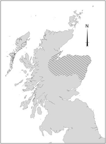
This study focuses on the regions of Aberdeenshire, Moray and Inverness-shire (Fig ). These modern local government areasFootnote6 loosely cover the heartlands of the regions of Fortriu and Cé of northern Pictland.Footnote7 Recent scholarship has suggested northern Pictland was a key region in the development of society in northern Britain in the post-Roman period. Alex Woolf has identified Fortriu, the Pictish kingdom most commonly cited in contemporary sources, as located in the Moray Firth region rather than in central Scotland as was assumed from the 19th century onwards.Footnote8 Historical sources suggest that by the end of the 7th century, Fortriu had established hegemony over most, if not all, of the other Pictish areas and this endured until the 9th century.Footnote9 Archaeological evidence underlines the importance of the region: Class I symbol stones are concentrated here;Footnote10 an early Pictish high-status settlement has recently been discovered at Rhynie, Aberdeenshire;Footnote11 and a series of early ringforts recently dated to the 5th and 6th centuries has been recognised in the same area.Footnote12 This has created renewed interest in areas of northern Pictland that at times have been considered peripheral to the major social and political transformations in northern Britain.Footnote13
Fig 1 Map of study area, encompassing the north-east of Scotland from eastern Inverness-shire to Aberdeenshire. Illustration by Juliette Mitchell. Base map © Crown Copyright/database right 2016. An Ordnance Survey/EDINA supplied service.
Previous Work on Pictish Monumental Cemeteries
In Wainwright’s classic 1955 edited volume, The Problem of the Picts, the lack of any conclusively Pictish examples of cemeteries meant that the discussion of burial traditions was limited.Footnote14 Nonetheless, in the same decade, the identification of long cist cemeteries in the Lothians and Fife led to the first characterisation of early medieval burial traditions in eastern Scotland.Footnote15 Recognition of monumental cemeteries of this period followed in the 1960s with the excavations of long cist burials in association with square and round cairns at Lundin Links, Fife.Footnote16 However, the biggest advances in our knowledge of burial traditions in Pictland came with the onset of the aerial survey programme by the Royal Commission for Ancient and Historical Monuments of Scotland (RCAHMS) in 1976,Footnote17 alongside more geographically focused survey programmes by local government Sites and Monuments Record (SMR) teams.Footnote18 Aerial reconnaissance during the hot summers of the mid-1970s revealed hundreds of previously unknown sites as cropmarks, especially in the rich arable zones along the coastlines of eastern and northern Scotland. These surveys identified an entirely new burial type — the square-ditched barrow with central grave.Footnote19 Upstanding monuments were also recorded and small-scale excavation provided further characterisation of a monumental Pictish cemetery tradition.
In the 1980s Pictish Studies: Settlement, Burial and Art in Dark Age Northern Britain gathered together excavations and surveys of many important sites for the first time.Footnote20 Synthetic reviews appeared in the same decade, summarising a growing body of evidence, with the long cist, the ditched barrow and the platform cairn identified as the three main categories of early medieval burial evidence in Scotland.Footnote21 The square and round cairns and barrows were frequently identified as a distinctive Pictish burial tradition; however, similar cemetery and burial types were also identified in the Northern and Western Isles, speculatively in Dumfries and Galloway, and also in Wales and western and eastern England.Footnote22 Thus, the monumental cemeteries located in Pictland were identifiable as part of broader British and Irish traditions.
Renewed interest in the monumental cemeteries of Pictland has been stimulated by the publication of past excavations and new research-led and development-led excavations.Footnote23 Together the evidence reveals that Pictish cemeteries vary in construction, size and form, but certain shared traits appear across all cemeteries.Footnote24 Where upstanding examples survive, they are generally low and flat topped, surrounded by either a stone kerb or a ditch and occasionally an outer bank. While round or square in plan, some display a degree of variation including ovoid, rectangular and trapezoidal forms.Footnote25 The ditched examples vary, with some bounded by a continuous ditch and others with broken ditches and in some cases, stone boulders or slabs are located at the corners, for example at Garbeg (Inverness-shire), Unst (Shetland), and Ackergill (Caithness).Footnote26 Particular materials seem to have been significant and the construction methods suggest time and care went into monument creation.Footnote27 Low-lying agricultural land was favoured for cemeteries and burials, with many on low terraces.Footnote28 The majority of barrows cover single graves, but cairns have also been shown to cover groups of individuals (as at Lundin Links, Fife and Ackergill). At Lundin Links skeletal analysis suggests that clusters of interments in particular monuments may be family groups.Footnote29 The orientation of graves is generally E/W with some variability within cemeteries and between sites.Footnote30 Conclusive dating of the cemeteries has been problematic, as lack of excavation and poor bone survival has limited the available material. Only two larger monumental cemeteries have been excavated to any extent, Redcastle, Angus, and Lundin Links neither in the present study area. Radiocarbon dating from both suggests burial activity took place in the 5th to 7th centuries ad (see below).Footnote31
Methodologies and Context
Aberdeenshire, Moray and Inverness-shire have, to date, seen limited close attention. Few of the sites have been excavated and most are documented only through aerial photographs. The current study was carried out as part of the University of Aberdeen’s Northern Picts project, directed by the second author. The Northern Picts project was established in 2012 to investigate the archaeology of Aberdeenshire to Easter Ross, covering the probable extent of the Pictish provinces/kingdoms known as Fortriu and Cé. Major fieldwork, as part of this project, has investigated high-status settlement and ritual sites, the location of a major silver hoard and other sites of early medieval date.Footnote32 A Geographic Information System (GIS) has also been constructed that documents all known sites of early medieval date within the study area, and has contributed to the results presented here. This study also draws on the completed MSc thesis and current PhD research at the University of Aberdeen by the first author. The latter reviewed evidence for monumental cemeteries using the online Canmore database and archive resources of Historic Environment Scotland (HES), Highland Council’s Historic Environment Record (HER) and Aberdeenshire and Moray Council’s online Sites and Monuments Records (SMR). The categorisation of each site was confirmed through desk-based analysis, and the transcription of individual sites was conducted where possible.Footnote33 Numbers of barrows and cairns were noted and a basic categorisation of cemetery size was conducted.Footnote34 Aerial reconnaissance has played a large role in the success of this study, but of course the aerial record can only ever be a partial record of the original extent and distribution of the archaeology for a particular region.Footnote35
The Pictish Cemeteries of Aberdeenshire, Moray and Highland
Of the 57 cemeteries recorded in the HES Canmore database, Aberdeenshire and Moray SMRs and Highland HER for the study area, 27 were considered ‘probable’ or ‘confirmed’ (Fig ; Tab ). It is these cemeteries that form the basis of detailed comparative study below. Eight of the remaining sites were deemed ‘unlikely’ and the rest, a total of 22, were recorded as ‘possible’. ‘Possible’ cemeteries are classed here as having only one potential barrow with unclear definition.
Fig 2 Distribution of monumental cemeteries in Aberdeenshire, Moray and Inverness-shire. The sites were classified by certainty based on the following criteria: Confirmed — excavated/upstanding/clear barrow and gravecut in cropmark(s); Probable –– reasonably convincing aerial photography cropmarks that show most of the ditch cut and grave cuts; Possible –– obscure cropmarks revealing only partial ditch cuts and/or geology and plough damage creating significant uncertainty regarding form; Unlikely –– sites that are unlikely to be barrows or cairns. Illustration by Juliette Mitchell. Base map © Crown Copyright/database right 2016. An Ordnance Survey/EDINA supplied service.
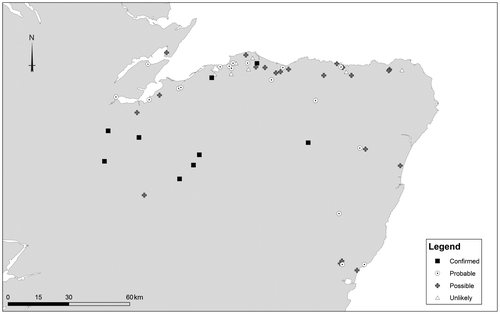
Table 1 Barrow sites in the study area.
Aberdeenshire
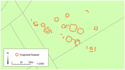
There are fewer sites and a smaller numbers of barrows in Aberdeenshire than in the other two local council areas, but this may be due to the generally poorer definition of cropmarks in Aberdeenshire (Tab ).Footnote36 Here, sites range from a single barrow at Boynds, to medium-sized cemeteries such as Hills of Boyndie. The latter sits on a high plateau in the parish of Banff (Fig ). Two square barrows and at least four circular barrows are visible as cropmarks, closely clustered together. None of the cropmark sites in Aberdeenshire have been excavated. One square cairn and two possible cairns were identified in the 1970s at Tillytarmont and two square barrows have been excavated at Rhynie (see below).
Fig 3 Hill of Boyndie, Aberdeenshire. An example of a clustered distribution of barrows situated on a high plateau overlooking the Bay of Boyndie on the Moray coast. Illustration by Juliette Mitchell. Base map © Crown Copyright/database right 2016. An Ordnance Survey/EDINA supplied service.
Moray
The barrow cemeteries of Moray are relatively small compared to examples in Inverness-shire (Tab ). They include single barrows at Kinloss Airfield and North Alves, and small cemeteries at Lower Auchenreath, Wester Coltfield and Midtown. Greshop Farm, near the River Findhorn, has complex cropmarking with square barrows evident to the south-east of a stretch of the river and settlement remains and/or further barrows to the south-west. Three of the square barrows at Greshop were excavated in advance of flood prevention works, including one barrow that was more than twice the size of the others (Fig ).Footnote37 No human remains were found due to acidic soils.Footnote38 The largest and most complex cemetery identified in Moray is Pitgaveny, located close to the former Spynie Loch (Fig ). Here, the remains of at least 10 square barrows and around five circular barrows are arranged in linear alignment. The barrows are very large, up to 20 m across, and at least four of the barrows appear to enclose smaller square-ditched features, possibly barrows. A further double square-ditched enclosure survives at Wester Buthill, along with two smaller barrows.
Fig 4 Greshop Farm (Pilmuir), Moray. Greshop was situated along a gravel embankment, south-east of the River Findhorn. A large square barrow with two adjacent smaller barrows were visible as cropmarks and were confirmed by excavation (Dunbar Citation2012). Further cropmark evidence suggests a barrow to the east, another to the north, and a cropmark group to the west comprising what appear to be settlement features, but may also include barrows. Illustration by Juliette Mitchell. Base map © Crown Copyright/database right 2016. An Ordnance Survey/EDINA supplied service.
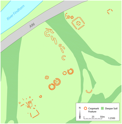
Fig 5 Pitgaveny (Pitairlie), Moray. A linear barrow cemetery with an exceptional number of large square barrows, some with multiple enclosing ditches. Illustration by Juliette Mitchell. Base map © Crown Copyright/database right 2016. An Ordnance Survey/EDINA supplied service.
Inverness-shire
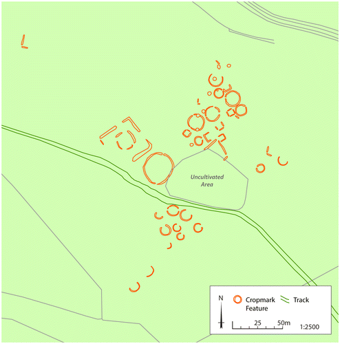
The smaller cemeteries known from cropmarks in Inverness-shire include sites such as Kerrowaid with two barrows and Allanfearn with seven (Tab ). An intriguing example is Kinchyle, where a large double-ditched square enclosure with a central, possible grave, pit, is clearly visible as a cropmark alongside a dense array of features, many of which may be prehistoric settlement features (Fig ). Slightly larger cemeteries in Inverness-shire are represented by sites such as Mains of Garten, located at a bend in the River Spey, comprising a cemetery of around 20 round and square barrows. Here, the geology and topography may obscure more examples (Fig ). At Poyntzfield on the Black Isle, a barrow cemetery of perhaps six barrows is evident, including round and square examples, running in a linear arrangement along a low terrace. The most impressive cropmark sites in this area are Croftgowan and Tarradale. The cemetery at Croftgowan comprises a linear setting of around 27 circular and square barrows located on the slope of Tor Alvie (Fig ). Areas of deeper soil may obscure more examples at Croftgowan. Tarradale House is located on a terrace overlooking the Beauly Firth (Fig ). Around 18 circular barrows, the largest 10–12 m in diameter, and eight square barrows each measuring around 5–6 m across, are evident, with two larger enclosures and a trackway.
Fig 6 Kinchyle, Inverness-shire. An extensive group of cropmarks was recorded by RCHAMS in the 1970s. This includes a double-ditched square enclosure or barrow with a central feature, possibly a grave cut. There are also a number of circular ditch features measuring 5 m to 9 m in diameter. Some of these may be barrows, but others appear to be later prehistoric houses. The field also has numerous other features including pits and ovoid features. Illustration by Juliette Mitchell. Base map © Crown Copyright/database right 2016. An Ordnance Survey/EDINA supplied service.
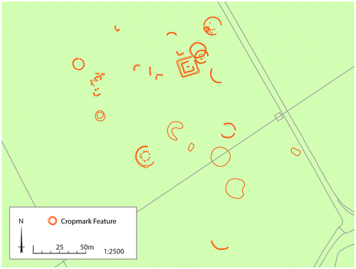
Fig 7 Main of Garten, Inverness-shire. At a bend of the River Spey, the cropmarks of a barrow cemetery of at least 20 round and square barrows are visible on aerial photographs. Thirteen of the barrows have a central feature, likely to be burials. Illustration by Juliette Mitchell and Georgina Brown. Base map © Crown Copyright/database right 2016. An Ordnance Survey/EDINA supplied service.
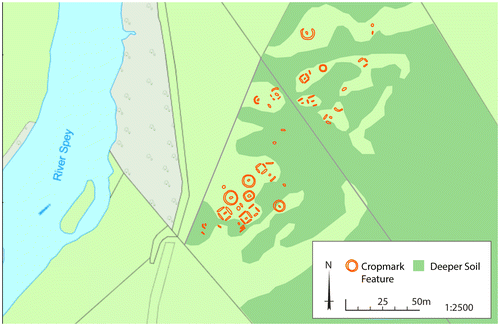
Fig 8 Croftgowan (Kinrara Farm), Inverness-shire. A linear cemetery of 27 circular and square barrows sits on an area of higher ground on the slope of Tor Alvie. At least 11 of the barrows display internal features presumed to be grave cuts. To the west of the barrows is an area of rough pasture. Antiquarian reports suggest several upstanding earthen barrows were levelled around 1800. Illustration by Juliette Mitchell. Base map © Crown Copyright/database right 2016. An Ordnance Survey/EDINA supplied service.
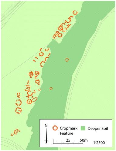
Fig 9 Tarradale House, Inverness-shire. Aerial photography has identified the remains of an extensive barrow cemetery on higher ground 1 km north-west of the mouth of the Beauly river where it joins the Beauly Firth. Around 18 circular barrows are visible, the largest being 10 to 12 m in diameter. Eight square barrows are also distinguishable, measuring around 5 m to 6 m in diameter. Central features are visible in at least five of the barrows, possibly indicating grave cuts. An area of uncultivated land obscures the central area of the cemetery. A circular and a square enclosure are also visible to the north-west, as well as a trackway which runs through the cemetery. Illustration by Juliette Mitchell. © Crown Copyright/database right 2016. An Ordnance Survey/EDINA supplied service.
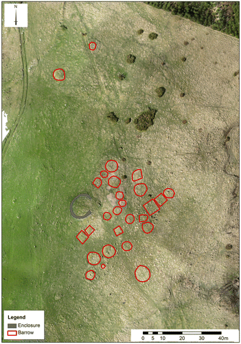
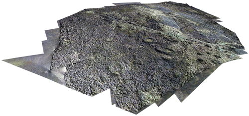
In addition, we are fortunate in Inverness-shire that a small number of upstanding cemeteries have also survived. The largest is Garbeg, where a total of 26 upstanding barrows have been recorded, including 14 square or sub-rectangular and 10 circular (Fig ).Footnote39 Here the square barrows range from 3.5 to 5.5 m across, and the round mounds are up to 10 m in diameter and nearly all have surrounding ditches. The mounds are of three types: flat-topped stony mounds which rise to a height of around 0.5 m, earthen mounds which stand to a height of c 0.2 m, and low stony mounds separated from their ditches by a berm. Four barrows were excavated in 1979 following the discovery of a fragment of a Pictish symbol stone associated with one of the round barrows, although no relationship was conclusively proven between the stone and the burial monuments.Footnote40 All examples overlay central inhumations, though the human remains were very badly preserved or non-existent in all cases.
Fig 10 Garbeg, Inverness-shire, barrow cemetery. Drone image with barrows outlined. Image by Oskar Sveinbjarnarson.
The second largest upstanding cemetery in Inverness-shire is at Whitebridge, situated on a ridge at the confluence of the River Fechlin. The cemetery consists of at least seven burial mounds and five small round cairns. The monuments are 4.5–9 m in diameter, and stand up to 1 m in height. One of the mounds has been excavated, but no human remains survived.Footnote41 Two smaller upstanding cemeteries also survive — Brin School and Pityoulish. Brin School sits on the eastern bank of the River Nairn on a low ridge and comprises five barrows. These two cemeteries contain both square and circular mounds up to 10 m in diameter and up to 0.6 m in height. At Pityoulish, monoliths project from three of the barrows. At this cemetery, one barrow was excavated in 1953 and human remains were recovered from a pit adjacent to the standing stone.Footnote42
General Characteristics
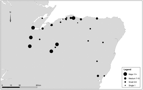
The aerial photographic evidence shows that most monumental cemeteries identified in the study area were relatively small in scale: 59% of the probable or confirmed examples contain six or less graves. This corresponds to both Winlow’s and Henshall’s analyses of cemeteries further south in Pictland, which suggest that many cemeteries were composed of one to six burials.Footnote43 However, the aerial evidence is likely to provide an underestimate of the total number of burials. Many cemeteries undoubtedly still await discovery; the barrows excavated at Rhynie, Aberdeenshire, for example, were not visible on aerial photographs despite the presence of other archaeological cropmarks in the same field (see below). Some cemeteries are also likely to be more extensive than they first appear. For example, at Kinchyle, Inverness-shire, four large square enclosures or barrows and four possible round barrows lie just over 800 m away at Little Kildrummie (Tab ). These barrows could represent additional elements of a very large cemetery, or a nearby related site. The larger cemeteries in the study area (Garbeg, Pitgaveny, Croftgowan, Mains of Garten, Tarradale) all have upwards of 11 barrows (Fig ). They display more variety in their size, shape and architectural construction, which could be suggestive of their importance, their longevity, or both. The monumental cemeteries identified in the study area may also include unenclosed graves, exemplified in the south at sites such as Forteviot, Perthshire, and Redcastle, Angus.Footnote44 At Redcastle, for example, excavation identified at least seven unenclosed graves without a defining cairn or ditch located near to the square and round barrows of the cemetery.Footnote45 There is little evidence of unenclosed graves in the aerial photographic evidence for our study area, but future excavation may well identify them.
Fig 11 Cemetery distribution according to known size. Illustration by Juliette Mitchell. Base map © Crown Copyright/database right 2016. An Ordnance Survey/EDINA supplied service.
Long cist cemeteries may also represent an aspect of Pictish burial tradition. However, although in Tayside and Fife around 90 examples are known,Footnote46 in the study area long cist cemeteries are rare — examples are restricted to a handful of sketchy antiquarian accounts and a small number found during development, but all are undated and unpublished. They are largely restricted to the southernmost part of Aberdeenshire and include five long cists found at two different locations in Stonehaven,Footnote47 another two at Johnshaven, Kincardineshire,Footnote48 and a single inhumation at Inverbervie.Footnote49 The lack of long cist cemeteries in the area may represent a real difference in the burial traditions of northern Pictland, or it could reflect a lack of defined detail in the cropmark evidence. Certainly nothing comparable to the long cist cemetery of Hallow Hill, Fife, where at least 150 inhumations were found, has been identified in the study area, though Hallow Hill is also exceptional for Tayside and Fife. In Tayside and Fife over half of the identified long cist cemeteries contain less than five graves.Footnote50 This is comparable to the size of most monumental cemeteries in the study area under discussion here.
The general trend, north of the Forth, is for small clusters of graves rather than extensive cemeteries.Footnote51 As well as number of monuments, other characteristics mark some cemeteries out. The majority of barrows and cairns conform to the sizes and types known elsewhere. The barrows are between 4 m and 12 m in diameter, and most lie towards the smaller end of that spectrum. Yet some sites contain barrows that are much larger than the norm, including examples of square and round barrows up to 25 m across. Examples of cemeteries with large barrows include Greshop, Pitgaveny, Wester Buthill (all Moray), Kinchyle, Inverness-shire and Hills of Boyndie, Aberdeenshire. In three of these cases oversized square barrows appear to have been enlargements of initially smaller monuments (Greshop, Pitgaveny, Kinchyle). Tarradale (Inverness-shire) also has larger circular barrows of 20 m diameter, but as yet with no evidence of multiphased development.
Landscape Location and Character
Relations to Topography and Routeways
Aerial photographic analysis of the landscape location of cemeteries in the study area reveals that cemeteries often form linear distributions that follow topographical features. These include areas of higher ground and rivers, similar to patterns observed in Tayside and Fife.Footnote52 It is possible that these linear distributions may reflect routeways through the landscape. At Croftgowan (Inverness-shire) for example, a major cemetery of 27 barrows follows a distinctive linear arrangement. This runs almost parallel to the route north from Stirling to Inverness where the traversable land narrows through the Cairngorm Mountains. Likewise, at Whitebridge, Inverness-shire, a cemetery of at least 12 upstanding monuments is located just north of the road that leads from Fort Augustus to Inverness and adjacent to a number of 18th-century and modern river crossings that include a natural ford. Dalbreck, Aberdeenshire, is also adjacent to a routeway that leads to a ford across the Water of Feugh. The site is also strategically located at the northern end of the route that leads across the Cairn O’Mount, a mountainous pass through the Mounth, an eastward projection of the Cairngorms.Footnote53 At Pitgaveny, Moray, the linear layout again leads to a ford across the River Lossie and there are also archaeological traces of an old road or routeway here.Footnote54 Garbeg, Inverness-shire, may also sit on an old route through the highlands that leads from the mouth of River Enrick at Loch Ness northwards to Beauly and Inverness.Footnote55 Greshop, Moray, is located just off the modern road from Forres to Nairn which crosses the River Findhorn, the same route followed on the earliest detailed maps for the area.Footnote56 Mains of Garten, Inverness-shire, may also sit at a river crossing, in this case over the River Spey, near the crossing at Boat of Garten where a ferry crossing, now replaced by a bridge, was located. On the other side of the river from the Mains of Garten cemetery is a Pictish Class I symbol stone, found at Lynchurn.Footnote57 Other examples of cemeteries show a more clustered layout, but some of these too may also relate to important land routes. The large barrow cemetery at Tarradale, Inverness-shire, for example, is dissected by a holloway that leads southwards to a landing place on the Beauly Firth (Fig ).Footnote58
Cemeteries and Settlements
Likely contemporary sites in the surrounding landscape include settlements and fortified enclosures. Unfortunately, evidence for Pictish settlement is still rare across much of mainland Scotland. In the lowlands there is an absence of settlement remains after the Iron-Age roundhouse tradition ceased, sometime around the 2nd or 3rd centuries ad.Footnote59 In the Northern and Western Isles, we have a richer settlement record that can include a variety of different house ‘types’, including oval, sub-rectangular, multicellular, semi-subterranean and figure-of-eight structures.Footnote60 The few Pictish settlement types known on mainland Scotland include structures with sunken floors at Easter Kinnear in Fife,Footnote61 and byre-houses in the uplands known as Pitcarmick-type buildings.Footnote62
In the study area virtually no unenclosed Pictish settlement evidence is known. The majority of the area is fertile, but intensively cultivated, land. Major agricultural improvements over the past 200 years have levelled upstanding features.Footnote63 Excavations at Granton, Moray,Footnote64 near Greshop cemetery, and Dalladies, Aberdeenshire,Footnote65 near Balmakewan cemetery, have identified ephemeral remains dating from the mid-1st millennium ad, broadly contemporary with the cemeteries. At Kintore, Aberdeenshire, pits and other structural remains indicate domestic and metalworking activity from later in the 1st millennium ad.Footnote66 However, even these very ephemeral traces of possible Pictish settlement are rare in the lowlands of eastern and northern Scotland.
For these reasons, it is difficult at present to situate the cemeteries within the settlement landscapes of the same period. However, in the upland landscapes towards the Great Glen in Inverness-shire better preservation exists, presenting an opportunity to study landscapes that have escaped the agricultural improvements and modern settlement expansion of the last few centuries. Three upstanding cemeteries are found along the Great Glen. The landscape in the wider environs preserves upstanding archaeological sites including hut circles and platforms, hillforts, and cairns. Fig shows all possible prehistoric to early medieval settlement remains within 5 km of the cemeteries at Garbeg, Whitebridge and Brin School.Footnote67 While none of the settlement remains are dated, and many undoubtedly date to the Bronze or Iron Age, their distribution demonstrates that the cemeteries are located in areas that were densely settled in prehistory. The most intriguing evidence for the potential juxtaposition of cemetery and settlement is at Garbeg, where oval and sub-rectangular houses, types that have parallels dated to the Pictish period in the uplands of Perthshire, are located a short distance away from the cemetery (Fig ).Footnote68 Barrow cemeteries were, it seems, located in prime agricultural areas, with some degree of importance placed on their accessibility to main routes across the landscape.Footnote69
Fig 12 Whitebridge, Garbeg and Brin School cemeteries showing the surrounding prehistoric hut circles, forts/duns and Pictish symbol stones within a 5 km radius around each cemetery. Symbol stones outwith the 5 km radius are also shown. Illustration by Juliette Mitchell and Derek Hamilton. Base map © Crown Copyright/database right 2016. An Ordnance Survey/EDINA supplied service.
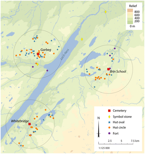
Fig 13 Sub-rectangular and oval houses at Garbeg. These provide good parallels for the ‘Pitcarmick’ style structures found in Perthshire. These are located 2 km from the cemetery at Garbeg. © Alan Thompson.
Cemeteries and Forts
More fortified sites in the study region have been dated to the 1st millennium ad than settlements, though the numbers are still small. As part of the Northern Picts project the data gathered were used in GIS to identify forts, duns or fortified sites lying within 5 km of cemeteries. Seventeen possible sites were identified; however, only two of those forts have confirmed Pictish phases of construction and use. One is the largest fort known in Pictland — Burghead, Moray, which is within 5 km of Wester Buthill, a site with a large square enclosure and three possible barrows. Wester Buthill is located near to one of the modern routes into Burghead from inland areas to the south. Garbeg, Inverness-shire, is located around 4 km north-east of Urquhart Castle. Urquhart Castle, excavated by Leslie Alcock, lies at the head of the Great Glen.Footnote70 Here, a medieval masonry castle overlay a site that Alcock suggested could have been the 6th-century fort (munitio) of Bridei, son of Mailcon, referenced in Adomnán’s Life of Columba.Footnote71 The scale of excavation at Urquhart was very limited, but suggested the presence of a hillfort enclosure on the craggy rock-boss upon which the later medieval motte stands, with possible lower terrace enclosures.Footnote72 Radiocarbon dating suggests activity began at Urquhart in the 5th or 6th centuries, and lasted into the early centuries of the 2nd millennium ad. All other forts within the vicinity of cemeteries are undated, but some examples where cemeteries and forts are closely juxtaposed are worthy of further investigation. Brin School, Inverness-shire, for example, is overlooked by the hillfort, Creagan An Tuirc, ‘the boar’s rock’.Footnote73 The old route adjacent to the cemetery also leads northwards towards Inverness where the spectacular Boar Stone at Knocknagael was located and another possible barrow cemetery. Croftgowan cemetery is located on the south-west slope of Tor Alvie, which has an undated fort on the summit. Other fortified sites may exist in the vicinity of Pictish barrow and cairn cemeteries. As outlined below, the barrows at Rhynie, Aberdeenshire, were located near to a contemporary fortified settlement and at Tarradale, Inverness-shire, excavations in 1991–1993 found a large ditched enclosure, palisade and internal features at a site just to the north-east of the barrow cemetery.Footnote74 Pottery from one of the internal pits has been suggested as early medieval in date, but the enclosure itself remains undated.Footnote75
Cemeteries and Symbols
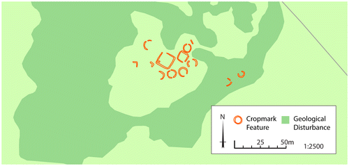
Even before Pictish burial traditions were fully identified, Wainwright postulated a relationship between symbol stones and burial.Footnote76 Since then the relationship of Pictish symbol stones to burial has been widely discussed.Footnote77 Of the 27 confirmed or probable sites in the study area, nine cemeteries have symbol stones or cross slabs within a distance of 5 km. However, few direct relationships can be identified and few are in close association with a cemetery. Fragments of a Class I symbol stone were found in 1974 at Garbeg, Inverness-shire, in association with one of the round cairns (Cairn 1).Footnote78 However, the stone is incomplete and no direct relationship with the cairn could be conclusively demonstrated. At Tillytarmont symbol stones have also been found in the close vicinity of potential burial monuments.Footnote79 In 1975 Tony Woodham excavated a small square cairn (4.25 m by 4.25m and 0.5 m high) made up of large waterworn boulders with evidence for a large central quartz monolith and identified two stone spreads that may have been other cairns. These were found in the same general area as five Pictish Class I symbol stones located on the haughland at Tillytarmont.Footnote80 However, no burial was found at the cairn and no direct association can again be demonstrated. Relationships at other sites are suggestive. At Mains of Garten, for example, a symbol stone was ploughed up in a field near to the cemetery, but in this case the stone was located on the opposite side of the river.
Barrows at Rhynie
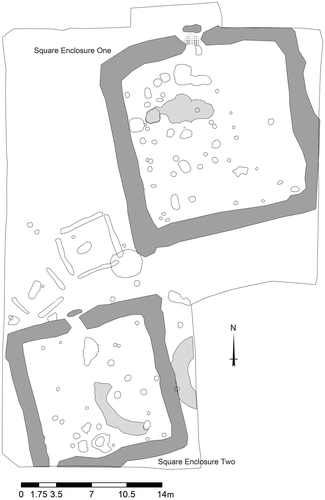
The most recent discovery of Pictish burial monuments in the study area is at Rhynie, Aberdeenshire, and this exemplifies a broad juxtaposition between barrows and symbol stone monuments. In 2013 excavations near the village of Rhynie uncovered two square barrows with central graves. Excavations in 2011–2012, less than 0.5 km to the south of the barrow locations, uncovered a fortified settlement of the 5th–6th centuries ad, defined by a plank- and post-built box rampart, inner and outer ditches and evidence for enclosed rectangular buildings.Footnote81 Late-Roman amphorae (B ware), along with fragments of imported glass and high-status metalwork including evidence for production, suggest a high-status site. The archaeological evidence can be set alongside the place name, which derives from early Celtic (Pictish) rīg, ‘king’, with the overall name likely to mean ‘place of or associated with a great king’.Footnote82 Eight Pictish Class I symbol stones are known from Rhynie, and burials and human remains have been recorded in close association with some of these stones since the 19th century. Three of the symbol stones come from the vicinity of the fortified settlement, two from the modern church and three others were found towards the southern end of the village. In 1836 two of the stones from the village (Nos 2 and 3) were removed during the construction of a turnpike road. A ‘quantity’ of human bones was found near the stones at this time. James Logan also states that Rhynie No 3, which depicts a warrior with a spear, was found in association with a cairn.Footnote83 Antiquarian reports and local newspapers also record the discovery of cists in the same general area. Isobel Henderson,Footnote84 for example, records three parallel cists being found during the construction of Ashvale cottage in the village, and E/W orientated cists are reported being found near the warrior figure, Rhynie No 3. The two square barrows excavated in 2013 were found a short distance to the south of where the two symbol stones and reports of human remains and cist burials were identified. They were found in association with two larger square enclosures that had been located on aerial photographs (Fig ). These two large square enclosures have short segments of ditch that project in front of an apparent entrance on the N side of each enclosure. The larger square enclosure measures around 20 m across and the smaller 16 m. The dating evidence for these larger enclosures is problematic, but dating of an upper fill of the ditch of the largest suggests it was still visible in the 7th century ad and a pit dating to the 5th–6th centuries ad was found inside. Each of the smaller square barrows measured 4 to 4.5 m across. In the centre of one, a stone-lined long cist containing the remains of an adult female was found. The second barrow contained traces of a wooden coffin in the central grave cut, but no surviving human remains. The central burials were aligned ENE/WSW and NE/SW respectively. Radiocarbon dates place these burials between ad 400–570 (see below), contemporary with the high-status settlement discovered in 2011.
Fig 14 Rhynie, Aberdeenshire. Plan of the two square barrows and two larger square enclosures excavated at the southern side of the village in 2013. Illustration by Rhynie Environs Archaeological Project.
Dating
The dates from Rhynie are the only scientific dates available for Pictish burial monuments in the study area.Footnote85 Two radiocarbon dates for the individual in the cist burial indicate the square barrow dates to between cal ad 400–570 (at 95% probability) (SUERC-52935 1559 ± 30 BP, cal ad 420–570; MAMS-21252 1602 ± 24 BP, cal ad 400–540).Footnote86 This corresponds well with the dating for the cairns and mounds of the two largest Pictish cemeteries excavated — Redcastle, Angus and Lundin Links, Fife (Fig ; Tab ). Square and round cairns may have been constructed earlier in the 1st millennium ad,Footnote87 but the floruit of this tradition can be placed in the 5th–6th centuries ad and the tradition appears to have largely ceased by the 7th century.Footnote88
Fig 15 Radiocarbon dating for the Rhynie square barrow with dates from Lundin Links and Redcastle. Note dates for the unenclosed graves from Redcastle have been omitted.
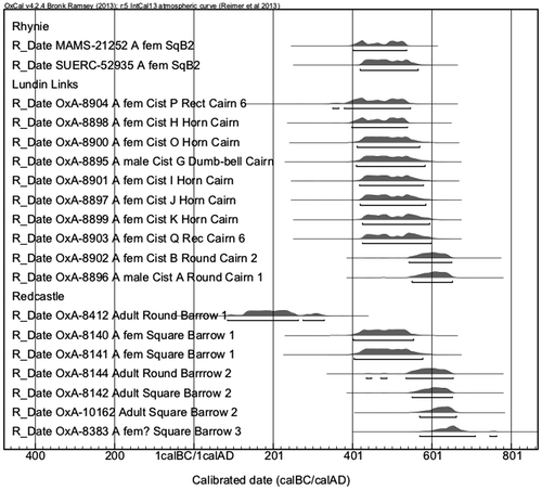
Table 2 Radiocarbon dates from Rhynie and comparative dates from Redcastle, Angus and Lundin Links, Fife. Only barrow and cairn inhumations are shown.
Discussion
The 5th–6th centuries ad, when the monumental cemeteries of Pictland flourished, are increasingly seen as a critical period in the formation of the early kingdoms of northern Britain and north-western Europe more generally. In north-eastern Scotland, at this time, fortified sites re-emerged after a hiatus in the later Iron Age.Footnote89 Class I symbol stones appeared and flourished; perhaps associated with new forms of identity and place-making in the post-Roman era.Footnote90 While there are examples of burial monuments and even small cemeteries in the earlier centuries of the 1st millennium ad,Footnote91 the establishment of monumental cemeteries marks an important transition in the visibility of the dead in the archaeological record.Footnote92 Across northern and eastern Scotland, from Shetland to the Firth of Forth, very similar burial monuments were constructed suggesting strong links between the dispersed communities of Pictland.Footnote93 In Scotland generally, burial becomes much more visible in the 5th and 6th centuries.Footnote94 The emergence of monumental cemeteries from the 5th century, and the dwindling occurrence of such monuments by the 7th century, mirrors patterns of change evident elsewhere in Britain and Ireland in this period. A shift towards church burial from the 8th century ad is also evident. What marks the Pictish monumental cemeteries out from other traditions in Scotland is the focus on the construction of elaborate earthen mounds and stone cairns to cover the dead.
The square and round barrows of Pictland can be paralleled with similar traditions of monumental graves across Britain and Ireland.Footnote95 In Ireland, enclosed cemeteries were established for the first time in the 5th–6th centuries ad, marking a change from the sparser burial evidence of the Iron Age.Footnote96 Some monumental or enclosed cemeteries were also created, including the construction of ‘settlement-cemeteries’ defined by ditches, ring ditches and cairns.Footnote97 However, while monumental cemeteries and mounds occurred in Ireland, the focus on individuals, which is common to Pictish barrows, remains rare. In Ireland, the enclosing of groups of burials within mounds, cairns or enclosures was more common. Nonetheless, there are examples in Ireland of cemeteries that appear to cluster around founder barrows or graves, and a very small number of these graves were furnished with gravegoods.Footnote98 In Wales the most typical burials from the 5th century onwards were (orientated) E/W and unenclosed, but enclosed graves are also known, including square enclosures that were probably barrows.Footnote99
The mound and cairn burials of Pictland, as identified in the study region, are overwhelmingly extended inhumations, unfurnished and generally orientated E/W. This arrangement had become widespread across the western Roman provinces by the mid-1st millennium ad and Pictish traditions seem to fit this more general shift in European mortuary practices.Footnote100 The lack of gravegoods has been seen as a distinguishing factor in the burial traditions of northern Britain, but in Ireland and western Britain contemporary burials were also generally unfurnished.Footnote101
The Pictish monumental cemeteries emerged prior to the elaborate princely burials of the late 6th and 7th centuries in Anglo-Saxon England, instead overlapping with the practice of a more modest barrow building tradition.Footnote102 Early Anglo-Saxon barrows are not generally associated with rich assemblages of gravegoods; it is the investment in construction, time and material that demonstrates wealth or status.Footnote103 Some contemporary Anglo-Saxon cremation cemeteries, in some instances, contained thousands of burials. Pictish cemeteries are more comparable with the Anglo-Saxon inhumation tradition, which involved the burial of smaller numbers of individuals with monumental markers such as barrows or ring ditches.Footnote104 In Pictland, the small number of mounds or cairns found at most sites suggests that this was not a common rite. They were instead acts of selective remembrance, perhaps commemorating only certain individuals. The presence of barrow monuments at sites such as Rhynie (and at the later royal centre at Forteviot in southern Pictland) implies that at least some of these monuments were part of high-status cemeteries, the mounds and cairns built for the few rather than the many.Footnote105 The chronological spread of mounds and cairns within individual cemeteries, with perhaps only a half dozen or so constructed over two or three centuries, also suggests a restricted, probably elite, practiceFootnote106 — episodes of construction that would have been memorable, creating powerful statements within the landscape.Footnote107
In Anglo-Saxon England, the building of mounds was in some cases at least, an elite practice. Martin Carver, among others, has connected the practice of mound building with the emergence of powerful hereditary aristocracies.Footnote108 Another connected practice is the reuse of antecedent prehistoric barrows as locations for burials.Footnote109 Both traditions are argued to have signalled a new elite presence in Anglo-Saxon society, with the use and manipulation of both landscape and burial rites employed to make visible statements of real or perceived ancestry and underline claims to power in the present.Footnote110
In Ireland, like Scotland, the lack of gravegoods has meant that questions of status or elite practice have not been addressed to the same level. Nonetheless, occasional gravegoods such as neck-or toe-rings, found in early medieval burials in Ireland, do tend to be associated with barrow traditions.Footnote111 Edel Bhreathnach has suggested that examples of central grave mounds within unenclosed cemeteries may also represent high-status burials.Footnote112 Patrick Gleeson has gone further, arguing that the multiple burials found in a small number of Irish barrows (as occasionally found within Pictish mounds and cairns) may be the burials of kindred heads of ruling lineages.Footnote113 High-status burials in Ireland also appear to have been inserted into prehistoric barrows, perhaps as a means of asserting the authority of particular lineages through reference to the ancestors or creating contrived lineages of the dead.Footnote114 In Wales, references in the early praise poem Englynion y Beddau suggest that burial in mounds was an elite practice.Footnote115
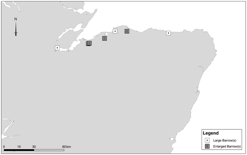
While similar forms of burial architecture are found throughout Pictland, generally there are no gravegoods distinguishing individual burials. Some monuments were made more prominent through the scale of the mounds or cairns. At Tarradale, Inverness-shire, for example, a series of round barrows were built on a much grander scale than the others, and the cemetery also contains an even larger circular enclosure, 36 m across its widest point — whether this too was a barrow, albeit greatly enlarged, remains to be seen (Fig ). Likewise, at Hills of Boyndie, Aberdeenshire, a cluster of barrows was centred around a large square barrow, 14 m across. The other very revealing phenomenon, laid bare by the plough-truncated form of most examples, is the occurrence of more than one set of enclosing ditches, suggesting barrow elaboration or perhaps enlargement. At Greshop, Moray, a square barrow 10 m across was enclosed by a set of additional ditches, creating a monument 28 m in length/width. The more elaborate monument at Greshop was the largest of three excavated at the site. The others measured 7 m and 8 m across and the inclusion of additional ditches greatly increased the size differential. Thus, from the outset or through time, one of the monuments at Greshop was made to stand out through a greater investment in labour and was more monumental in form. Once complete, it was around four times the size of the other barrows in the cemetery and would have required approximately 16 times the volume of soil in its creation.Footnote116 At Kinchyle, Inverness-shire (Fig ), a square barrow appears to have been enlarged and elaborated, the monument consists of average sized smaller ditches/barrows, around 8–10 m across, encased within an additional ditch extending to around 20 m in length/width. The role of the larger square enclosures at Rhynie is uncertain, but given that other cemeteries in northern Pictland have greatly enlarged monuments, it is possible that these too were large burial monuments.Footnote117 If this is the case, then these are four times the size of the smaller barrows identified at Rhynie.Footnote118 The phenomena of creating monumental barrows on this scale or enlarging barrows, cairns or enclosures, is are little recognised traditions in Pictland. A handful of larger barrows are known in southern Pictland, in Tayside and Fife, such as Hallhole, Perthshire, but there has been little discussion of their significance.Footnote119 The monumental and/or enlarged barrows are evenly spread across the study area, suggesting they may have been regionally significant monuments and/or cemeteries (Fig ).
Fig 16 Distribution of cemeteries with enlarged barrows. Illustration by Juliette Mitchell. Base map © Crown Copyright/database right 2016. An Ordnance Survey/EDINA supplied service.
The cemetery with the greatest monumental investment in the study area is at Pitgaveny, Moray (Fig ). Pitgaveny is a farm adjacent to Spynie Palace, the principal residence of the bishops of Moray from at least the 13th century, and both sites were located close to the shores of the extensive former sea loch of Spynie. The cemetery at Pitgaveny consists of at least six very large square barrows (probably more) and three round barrows or ring ditches. At least four barrows appear to have been elaborated — in one case ditches less than 8 m across were contained within much larger square barrows/enclosures some 20 m across. The Pitgaveny cemetery also shows clear evidence for the arrangement of the barrow cemetery in rows, and the joining of barrows through the sharing of barrow ditches, to create linear distributions of interlinked barrows. The barrows were arranged in two main rows, aligned ESE/WNW. The southern row had at least seven barrows, but nine may have been joined together in total.
The conjoining and elaboration of certain barrows may be related phenomena. Both developments suggest the importance of particular members of society, and imply that the creation of lineages of the dead (whether real or fictive) may have comprised an important element in the establishment and maintenance of cemeteries.Footnote120 One of the major transformations of the early medieval period was the instigation of a hereditary aristocracy and the emergence of individuals with sufficient power and authority to call themselves kings. The growing power of these elite rulers seems to be reflected and materialised in the development of fortified sites in Pictland.Footnote121 The occurrence of elaborate fortified enclosures from at least the 5th century onwards implies an increase in social differentiation. At the same time monumental cemeteries proliferated and their architecture suggests that these monuments may also have been implicated in the establishment and maintenance of hierarchy. The transition towards hereditary aristocracy relied on the creation and maintenance of lineage and the linking of leadership to a powerful past where ancestry was critical.Footnote122 In early Irish literature burial places were seen as nodal points through which the Otherworld and the world of the dead could be accessed and cemeteries were one means by which lineages were forged.Footnote123 Pictish barrows and cairns may have acted in similar ways, through these places claims of lineage and kinship may have been materialised and genealogies created that were instrumental in establishing hierarchical social relations. The establishment of monumental cemeteries in Pictland is commensurate with the first mentions of kings in northern Britain, while the decline of the tradition in the 7th-century coincides with the references to an over-king of the Picts.Footnote124 Thus the creation of the first large formal cemeteries since the Bronze Age in north-eastern Scotland may go hand in hand with the establishment of regional hegemonies across Pictland. Their demise or the cessation of such rites was perhaps prompted by increasingly centralised forms of authority.Footnote125
Claims over land, lineage and rulership of a people are recognised as increasing concerns in early medieval life. The establishment of formal cemeteries would have been an obvious way to legitimise claims to territory, through reference to ancestry, and create connections between particular lineages and locations.Footnote126 The creation of cemeteries also resulted in the identities of particular lineages being much more obviously fixed in relation to particular locations in the landscape.Footnote127 The elaboration and/or enlargement of particular barrows in the study region also suggests that particular ancestors were emphasised or their status even contested. The linking of monuments to one another through the sharing of ditches or the conjoining of barrows may have situated the dead within particular relational networks of ancestry, and may have signalled evolving alliances and powerful emerging lineages.Footnote128
Within cemeteries such as Greshop, only a single barrow seems to have been emphasised through the construction of a much larger monument, but at others such as Pitgaveny, four barrows were emphasised or enlarged and the majority of the barrows in the cemetery were changed into large monuments up to 20 m across. This suggests that while the burial places of some individuals were elaborated, and perhaps increasingly venerated through time, at Pitgaveny the whole cemetery population was marked as important through investment in the construction of the earthen mounds and ditches that enclosed the burials. While particular individuals buried in certain barrows may have been important in life, what perhaps mattered more were the ways in which the living community manipulated the status of the dead and the architecture of the cemetery for their own needs.Footnote129 The aggrandisement of particular barrows and cemeteries was an act that would have been socially and politically charged. The elaboration and/or enlargement of existing barrows may have happened during the creation of other monuments or as part of other important social events, whereas the creation of new mounds could have been occasions when social relations were established, reworked and maintained. In this respect, social structure was not simply reflected in architecture of this kind; it was actively forged and manipulated through the creation of cemeteries.Footnote130 Each mound or cairn constructed altered the form of the landscape through a process of accretion, each adding to an evolving narrative that embodied the community of both the living and dead.Footnote131
The monumental cemeteries of Pictland may allow us to glimpse how new forms of social order were established in the 1st millennium ad. The mounds, ditches and cairns, for example, may have been constructed through bonds of clientship: by taking part in the creation of architecture like this, people were actively creating the material frameworks that underpinned an emerging social order and hierarchical society. The materials used — the mounds of earth and stone — may have been designed to add a literal and metaphorical permanency to the social relations being expressed,Footnote132 and through their solidity acted as a powerful material mnemonic that helped create and maintain a new social order.Footnote133
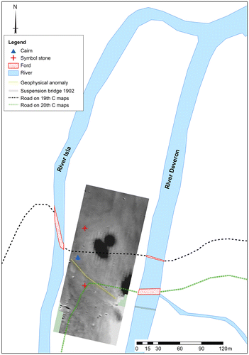
How these cemeteries were situated within the early medieval landscape is also important. While some of these barrows and cairns could reach proportions of up to 25 m in diameter or more, they were not generally located in highly conspicuous locations that would have been visible for kilometres around. The analysis of the barrows in the study area suggests they were located on more locally visible terraces and knolls. In addition a number were situated in areas tied into the geographies of routine movement: on routeways, at fording points and on general lines of movement through the landscape. Some cemeteries were also located at key transitional points in the landscape. The cairns at Tillytarmont, Aberdeenshire, for example, are located at the confluence of two rivers (Fig ) and a boundary location between two old counties, the division between three later medieval parishes and the site of a number of fords and crossing places. The place name itself derives from tulach – a term often associated with assembly.Footnote134 Tillytarmont is the findspot of five Class I symbol stones since the 19th-century suggesting the cemetery was a component in wider landscape of Pictish power. In Anglo-Saxon England some field cemeteries seem later to have become important assembly places.Footnote135 Gleeson has also highlighted the roles that so-called ‘cemetery-settlements’ may have played in assembly practices in Ireland.Footnote136 The location of Tillytarmont on an important natural and cultural boundary and its place-name evidence may similarly suggest the cemetery was located in an area that functioned as a place of assembly. This particular cemetery also shares characteristics with the burial places in Ireland known as ferta, which acted as places of legal assembly and as boundary markers and protectors of the land and territory of particular kin groups.Footnote137 The second element of the Tillytarmont place name, derives from an tearmainn ‘sanctuary’, which implies that in a later period there was also an important church nearby.Footnote138 Tillytarmont may represent an important site of assembly and burial that originated in a pagan context, but continued as an important place in a Christian milieu.Footnote139
Fig 17 Location of Tillytarmont with symbol stones and cairn marked. Fords and routeways crossing the haughland, as represented on 19th- and 20th-century maps, are also shown. The location of the two symbol stones is based on good locational information. The other three stones were found on the haughland, but these cannot be accurately located. A geophysical plot carried out by Oskar Sveinbjarnarson for the Northern Picts project is also superimposed on the image to show geophysical anomalies that coincide with the routes across the haughland. Image by Oskar Sveinbjarnarson. Base map © Crown Copyright/database right 2015. An Ordnance Survey/EDINA supplied service.
The landscape setting of these monumental cemeteries also reveals something of the wider geographies of northern Pictland. With the exception of Rhynie, there are no known close juxtapositions between confirmed Pictish fortified sites and cemeteries in the study area. The cemeteries thus may offer important clues to additional important nodes in the Pictish landscape and may signal elements of an emerging multifocal landholding system that formed the basis of power for high-status Pictish communities.Footnote140 What is also notable is the lack of a clear relationship between monumental cemeteries and Pictish stones. Symbol stones have been found in close proximity to monumental cemetery sites in only a handful of cases.Footnote141 Indeed, GIS analysis casts further doubt on the connections between burial sites and symbol stones: as part of the Northern Picts project the locations of 337 Pictish Class I and II carved-stone monuments were compared to those of 233 long cists or long cist cemeteries and 110 square barrow or cairn locations (as recorded in the Canmore database), across Perthshire and Fife to Caithness. Only 14 of 337 Pictish carved-stone monuments were found within 500 m of a long cist or square barrow (less than 5%) and only five of those 14 examples were square barrows or cairns. In 2007 Clarke critically examined the relationship between symbol stones and sites of burial and concluded that the case for a connection was weak.Footnote142 Our GIS locational analysis reinforces this impression. It seems that a direct relationship existed between Pictish cemeteries and symbol stones only in exceptional cases.Footnote143
The analysis of the symbol stones suggests that they had more varied purposes than just gravemarkers. In this respect they can perhaps be directly compared to the ogham stones of Ireland. Most ogham stones in Ireland appear to have been inscribed in the 5th–6th centuries ad and, where decipherable, appear to have been used to express the genealogies of elite members of society. In the past these have been interpreted as burial markers but, like Pictish symbol stones, there are very few examples of stones found in direct association with graves. Some may be memorials, but others had a legal function concerned with boundaries and landholding, acting as ‘visible, physical declarations of land possession’.Footnote144 Thus, ogham stones may have acted in similar ways to barrows, proclaiming the rights and genealogies of particular elite lineages.Footnote145 The Pictish Class I symbol stones appear, like the Irish ogham stones, to have been markers of elite identities.Footnote146 They may have complemented the role of cemeteries in marking important landscapes of power and perhaps directly indicated land ownership and rights. There are similarities here in the ways symbol stones and barrows expressed ideas about identity: on occasion symbol stones, like barrows, appear to have symbol sets added, and in a smaller number of cases symbols were overwritten by new carvings.Footnote147 This implies the identities expressed on symbol stones were cumulative, and the overwriting of symbols might demonstrate that these identities were reworked or even directly contested.Footnote148
The 5th–6th centuries ad, when monumental cemeteries were at the height of their use, was a period of change in northern Britain. One of the major changes was the growing influence of Christianity.Footnote149 The establishment of the monumental cemeteries of southern Pictland has often been discussed in relation to changing religious practices.Footnote150 Although a linkage to the creation of particular lineages is not in doubt, these burial monuments also drew on other influences, such as the adoption of E/W burial, Christian belief and local practices and traditions.Footnote151 The end of barrow traditions in the 7th century has been connected in this article to the centralising of power in Pictland, and parallels have been drawn with Ireland.Footnote152 Christianity, however, may have played a role too — in Ireland the church influenced the shift away from ancestral burial grounds as it grew in power in the 7th and 8th centuries.Footnote153 In Anglo-Saxon England the recent Bayesian modelling of radiocarbon dates by John Hines and Alex Bayliss has suggested a strong correlation between the end of elaborate furnished burial and the consolidation of the early Church in Anglo-Saxon England in the third quarter of the 7th century.Footnote154
In Pictland the dating is less precise, but the influence of the church is evident in the establishment of monasteries from the 7th-century onwards — a time when the tradition of constructing monumental cemeteries was coming to an end.Footnote155 By the 8th and 9th centuries, at the latest, important churches were also found at royal settlements.Footnote156 Thus, in Pictland, the ending of the construction of monumental cemeteries may also have been connected to the changing character of belief. The cessation of the construction of monumental cemeteries may have been connected to the ways in which elites incorporated the Christian faith into ideologies of rulership. In particular, we can perhaps highlight the effects that Christianisation may have had on conceptions of the self and genealogy. In a Christian context genealogies appear to have been altered to focus on family and individual relationships with God. With the consolidation of power in 7th-century Pictland, the local and regional genealogies that barrow cemeteries helped create may have been no longer sufficient to express the authority of elites who began to rule larger territories. It is perhaps in this context that we see disinvestment in the architecture of the dead, and greater interest in other forms of elite monument that more clearly expressed the relationship of elites to their Christian faith. The most obvious example is Class II Pictish sculpture, likely 7th–9th century in date. These monuments are carved with depictions of elites, often mounted on horseback, shown in close juxtaposition with monumental Christian crosses and/or the image of David.Footnote157
Conclusions
Monument building often occurs at horizons of social change and centralisation, with the greatest labour inputs occurring in transitional periods in the establishment of elites.Footnote158 As Barrett notes,Footnote159 elites are not merely created through the completion of monumental projects, but hierarchy emerges through the initiation and realisation of such projects. Emulation, competition and a desire for power within an emerging early medieval society may have been a strong motivating factor in the construction of monumental cemeteries in Pictland.Footnote160 In this article the rich aerial photographic archives available for north-eastern Scotland have been brought together for the first time, and used to review the evidence for burial traditions in an area of Pictland central to the establishment of the Pictish kingdoms of northern Britain. While few sites have been excavated, the transcription of the aerial evidence for northern Britain is an important resource in assessing how burial architecture may have been deeply implicated in the creation of new forms of society in northern Europe in the first millennium ad. In this area of northern Europe the appearance of formal cemeteries and the creation of the Pictish monumental cemeteries can be seen to go hand in hand with the establishment of a more hierarchical form of lineage-based society.Footnote161 The end of this tradition can be linked to changes within the social, political and religious order, with the dead becoming a less prominent source of power as supra-regional polities emerged and the Christian faith achieved firmer ground.
| Abbreviation | ||
| RCAHMS | = | Royal Commission for Ancient and Historical Monuments of Scotland |
Acknowledgements
This work was supported by Arts and Humanities Research Council [AH/L503915]. Thanks are due to Bruce Mann and to Aberdeenshire Council Archaeology Service for reviewing their archives and providing aerial photographs for transcription; to Dave Cowley and Oscar Aldred of Historic Environment Scotland for critical feedback and peer review of the aerial transcriptions; and to Georgina Brown and Derek Hamilton for guidance on the presentation of the transcriptions in Adobe Illustrator. We are grateful as well to Eric Grant for some thoughts on the layout of the barrows at Tarradale, to David Strachan for discussions on Pictish settlement, and to Sarah Winlow for discussing examples of ‘giant’ barrows in southern Pictland. Lindsay Dunbar kindly provided plans and the Data Structure Report for Greshop. Oskar Sveinbjarnarson, project manager of Northern Picts, helped produce some of the images and constructed the Northern Picts project GIS. Particular thanks to Dave Cowley, Patrick Gleeson, Derek Hamilton and Gabor Thomas who read through drafts of the article and to the two anonymous referees. All errors remain the responsibility of the authors.
Notes
3 Eg Alexander Citation2005; Greig et al Citation2000; Proudfoot Citation1996; Rees Citation2002.
4 Maldonado Citation2011a; Citation2011b; Citation2013; Williams Citation2007.
5 The work of Sarah Winlow, in Citation2011, provided a thorough review and discussion of the distribution of both the monumental and long cist cemeteries of Tayside and Fife, but there has been no systematic transcription of the cropmark sites from this region. Regional summaries have also been made of Angus (Dunwell and Ralston Citation2008) and Caithness (Heald and Barber Citation2015).
6 Inverness-shire is the south-eastern region of the Highland Council local government area.
7 Fortriu is a difficult term to define and appears to have referred to both a territory and to the Pictish overkingship. As a territory it almost certainly included the area of Moray, but may have extended as far north as the Black Isle and other areas of Ross and Inverness-shire: Woolf Citation2006, 192. It may have encompassed the later medieval bishoprics and earldoms of Moray and Ross: Evans Citation2014, 68. Cé is more problematic — it only survives in one place name, Bennachie in the Garioch, and is likely to have included significant parts of modern Aberdeenshire: Dobbs Citation1949; RCAHMS Citation2007, 116.
8 Woolf Citation2006; Citation2007.
9 Evans Citation2014, 58.
10 As noted by Henderson Citation1958, but largely ignored since; see distribution map in RCAHMS Citation2008, 11; Woolf Citation2006.
11 Noble et al Citation2013.
12 Cook Citation2011.
13 Fraser Citation2009, 109; Henderson Citation1958, 55; RCAHMS Citation2007, 115–16.
14 Wainwright Citation1955b, 94–6.
15 Henshall Citation1956.
16 See Greig et al Citation2000. Reviews of the antiquarian literature also identified other examples, such as Ackergill, Caithness, where excavation in the 1920s has identified a complex of square and circular cairns: Close-Brooks Citation1984; Ritchie Citation2011.
17 Maxwell Citation1978.
18 For example, the work of Ian Ralston, Ian Shepherd and Moira Greig as part of the Aberdeen Archaeological Surveys and Aberdeenshire Council Archaeology Service aerial reconnaissance programme.
19 RCAHMS Citation1978, 9–10.
20 Friell and Watson Citation1984.
21 Ashmore Citation1980; Close-Brooks Citation1984.
22 Ashmore Citation1980; Close-Brooks Citation1984; Cowley Citation1996; Longley Citation2009, 113–15; O’Brien Citation1999; Citation2009, 148.
23 Eg Dunbar Citation2012.
24 Winlow Citation2011.
25 Ashmore Citation1980.
26 Wedderburn and Grime Citation1984; Bigelow Citation1984; Ritchie Citation2011.
27 Alexander Citation2005, 157; Bigelow Citation1984, 115; Ritchie Citation2011, 136; Winlow Citation2011, 357.
28 Winlow Citation2011, 346.
29 Greig et al Citation2000, 603; Williams Citation2007.
30 Winlow Citation2011, 343.
31 Maldonado Citation2013, 20.
32 Eg Noble et al Citation2013; Noble et al Citation2016.
33 Images were rectified and georeferenced using VectorMap Local, an Ordnance Survey basemap. VectorMap local grid squares for sites in Inverness-shire, Moray and Aberdeenshire were downloaded via Edina Digimap Ordnance Survey Service <http://digimap.edina.ac.uk> [accessed during the months of May to August 2014]. Detailed recordings of the cropmarks identified from aerial photographs were rectified using Aerial 5.10 and transcribed using ArcGIS 10.2. Final images were produced using Adobe Illustrator.
34 Cemetery size was identified as follows: major 11+ barrows; medium 7–10; small 2–6; and single barrows. These categories broadly follow that of Winlow Citation2011 and Henshall Citation1956.
35 It is important to note that the distribution of such sites is heavily dependent on patterns of modern land-use, rainfall and the character of soils and drift geology. Thus, across Scotland, cropmark sites are concentrated in areas set to arable, on well-drained soils where crop stress is more likely, and in areas such as the eastern coast where average rainfall tends to be lower. This broad pattern can be illustrated at a very local level, for example, at Mains of Garten (Fig ), where the visibility of cropmarks depends on local variations in soil depth.
36 Fraser and Halliday Citation2011, 312.
37 Dunbar Citation2012.
38 Ibid.
39 Wedderburn and Grime Citation1984.
40 Stevenson Citation1984; Wedderburn and Grime Citation1984.
41 Stevenson Citation1984; Alexander Citation2000.
42 Rae and Rae Citation1953.
43 Henshall Citation1956; Winlow Citation2011, 341.
44 Campbell and Maldonado Citationforthcoming; Alexander Citation2005.
45 Ibid, 94.
46 Winlow Citation2011, 344.
47 RCAHMS Citation1984, 17, nos 82 and 83.
48 RCHAMS 1982, 19, no 135.
49 Ibid, no 134. The remains are held at the University Museums Service, University of Aberdeen.
50 Winlow Citation2011, 344–6.
51 Eg Maldonado Citation2013, 9–11 and Dunbar and Maldonado Citation2012.
52 Winlow Citation2011.
53 Small Citation1974 argues that this was an important routeway in the early medieval period. At Cairn O’Mount, a cross slab has been found at St Ringan’s (NMRS: NO67NE 15).
54 NMRS: NJ26NW 51.
55 The modern route to Inverness was dynamited along the western side of Loch Ness.
56 As shown on Roy’s Military Survey of Scotland map, 1747–55:<http://maps.nls.uk/roy/index.html> [accessed September 2016].
57 RCAHMS Citation2008, 74.
58 Gregory and Jones Citation2001, illus 1; Yeoman Citation1988, 131, no 92.
59 Hunter Citation2007, 49.
60 Ralston Citation1997.
61 Driscoll Citation1997.
62 RCAHMS Citation1990; Carver et al Citation2012; Strachan and Sneddon Citation2013.
63 RCAHMS Citation2007, 17–24.
64 Cook Citation2003.
65 Watkins Citation1981.
66 Cook and Dunbar Citation2008, 149–59.
67 Around half of the sites that have been surveyed are more ovoid and sub-rectangular than circular, which may suggest an early medieval or later date.
68 NMRS NH53SW 11; Carver et al Citation2012. The University of Aberdeen Northern Picts project is currently undertaking geophysical survey and evaluative excavation at a number of these house sites.
69 Reynolds (Citation2002, 186) highlights the location of many Anglo-Saxon cemeteries within or near major settlements. The occurrence of ‘pit’ place names which contain the place-name element pett, ‘a piece of land’, as found in Pitgaveny, may further corroborate these as settlements, although the age of these names is in some doubt — see Taylor (Citation2011) who argues that the place names relate to the expansion of Gaelic in the 10th century, but see also Evans (Citation2014, 33–7) who argues that these names are older.
70 Alcock and Alcock Citation1992.
71 Alcock Citation1981, 159–61.
72 Alcock and Alcock Citation1992, 260.
73 Taylor with Markus Citation2012, 342, 520.
74 Gregory and Jones Citation2001, 242, 245, illus 1 and 3.
75 McGill Citation2001, 255–8.
76 Wainwright Citation1955b, 87–96.
77 Eg Close-Brooks Citation1980; Clarke Citation2007, 27–31; Ritchie Citation2011, 133–4; Foster Citation2014, 64–5.
78 Wedderburn and Grime Citation1984, 151–2.
79 See Gondek Citation2010 for a full discussion of the site and stones.
80 Woodham Citation1975, 6.
81 Noble et al Citation2013.
82 Simon Taylor and Julianna Grigg pers comm. See also Grigg Citation2015 and Taylor with Markus Citation2012, 407–12.
83 Logan Citation1829, 56.
84 Henderson Citation1907, 163.
85 A date was obtained from human remains recovered from one of the cairns at Garbeg, Inverness-shire, but returned a very late date (11th–12th century ad) and recent resampling suggests contamination (Kate Britton pers comm.).
86 Radiocarbon dates presented in the text and in Table are calibrated using the IntCal13 calibration curve (Reimer et al Citation2013) and the computer program OxCal v4.2 (Bronk Ramsey Citation2009), and are given at 95% probability range.
87 Eg Murray and Ralston Citation1997; Neighbour et al Citation2000.
88 With the exception of Forteviot where recent dating of grave fill and ditch fill suggests the construction of mounds into the 8th or 9th century ad, but note that skeletal remains were not recovered and the dates were on charcoal in the grave fill: Campbell and Maldonado Citationforthcoming.
89 Noble et al Citation2013.
90 Driscoll Citation1988; Forsyth Citation1997; Noble et al Citation2013.
91 Maldonado Citation2011b; Citation2013.
92 As identified by Maldonado Citation2011b; Citation2013.
93 Bigelow Citation1984, 127; O’Brien Citation2009.
94 Maldonado Citation2013, 1.
95 Longley Citation2009, 112–15; Maldonado Citation2013, 17.
96 O’Brien Citation2009, 136–8.
97 O’Sullivan et al Citation2014, 283–99.
98 Bhreathnach Citation2014, 125–6.
99 Longley Citation2009, 113.
100 Eg Halsall Citation2012, 15; Hines and Bayliss Citation2013, 553.
101 Carver Citation2005; Dickinson Citation2011, 230; O’Brien Citation2009, 145.
102 Carver Citation2005; Dickinson Citation2011, 230; Geake Citation1992; Welch Citation2011, 269.
103 Scull Citation2009, 277.
104 Dickinson Citation2011, 229; O’Brien Citation2009, 137–48. And similar to the generally small size of cemeteries in Scotland in the early medieval period: Maldonado Citation2013, 10.
105 Campbell and Maldonado Citationforthcoming.
106 Alexander Citation2005, 110.
107 Cf Mizoguchi Citation1993.
108 Carver Citation2002, 136.
109 The phenomenon of monument reuse and its connection to elite strategies has been studied in some depth in Anglo-Saxon contexts, cf Semple Citation2003; Citation2008; Citation2013; Williams Citation1997; Citation2006.
110 See for example Lucy Citation1992; Citation1998; Halsall Citation2010; Semple Citation2003; Citation2008; Citation2013; Williams Citation1996; Citation2006.
111 O’Brien Citation2009, 142–3. The construction of a ferta for the burial of two daughters of Lóiguire, a king, is recorded in the Life of St Patrick, and the burial of Bishop Cethiachus in a ferta is referenced in early Irish sources: O’Sullivan et al Citation2014, 293. In the former case there is specific reference to a round ditch but no mound. O’Brien and Bhreathnach (Citation2011, 53) state that fert and ferta refer to grave mounds, but the term does not necessarily imply a mound: Gleeson Citation2014, 672–3.
112 Bhreathnach Citation2014, 125–6.
113 Gleeson Citation2014, 162.
114 O’Brien and Bhreathnach Citation2011, 55; O’Brien Citation2009, 149. See also, in reference to Anglo-Saxon practices: Lucy Citation1992; Citation1998; Halsall Citation2010; Semple Citation2003; Citation2008; Citation2013; and Williams Citation1996; Citation1997; Citation2006.
115 Longley Citation2009, 115.
116 Of course this is a plough-truncated monument, but examples such as Hallhole, Perthshire, an upstanding square barrow that survives up to 15 m across, demonstrate that large barrows of this form existed.
117 At Forteviot, the larger square enclosure in the cemetery has been interpreted as a shrine: see Campbell and Maldonado Citationforthcoming.
118 The lack of contemporary internal features in the Rhynie large enclosures could be explained by the presence of an internal barrow.
119 Winlow Citation2011, 337, fig 10.4. Other possible examples are Wester Denhead, Perthshire, where there is a double-ditched square enclosure at least 20 m across visible in aerial photographs, and Kettlebridge, Fife, where a square barrow around 25 m across is located next to two very large round barrows. The large barrow at Hallhole was enclosed by two ditches, each with external banks, which suggests that in the cropmark record more than one ditch could represent multivallation as well as barrows being enlarged. However, examples such as Pitgaveney, where barrows were enclosed by square ditched enclosures, but not always on the exact same alignment, also suggest that some monuments probably were enlarged through time. In either case, whether multivallation or enlargement, the presence of additional architectural elements suggests that some barrows were marked out as being different to others through greater investment.
120 Williams Citation2007.
121 Halsall Citation2012, 20; Noble et al Citation2013.
122 Gleeson Citation2012, 9.
123 Ibid, 23–4.
124 Evans Citation2008, 9.
125 The 7th century is when Fraser (Citation2011, 27) argues Pictish ethnogenesis took place, and when regional hegemonies and the over-kingship of Fortriu emerged (See also Evans Citation2008, 7–9). See Noble et al (Citation2013) for a similar discussion on forts, with fewer and larger sites evident through time in northern Pictland. Gleeson (Citation2015, 46) also discusses similar changes in Ireland with reference to ‘cemetery-settlements’.
126 Barrett Citation1994, 61–3; Binford Citation1971; Härke Citation2001, 11, 19; Lucy Citation1992; Saxe Citation1970; Semple Citation2013; Williams Citation1997.
127 Semple Citation2013, 14.
128 Williams Citation2007
129 Barrett Citation1994, 51. For a contemporary example see Ó Corráin (Citation1998) who discusses the use of unimportant or invented ancestors by lineages who acquired power centuries later. We thank Patrick Gleeson for highlighting this example.
130 Similar arguments regarding the use of burial architecture to underline particular familial relations and the establishment of lineage have been made for other Pictish and early medieval cemeteries more generally. At Lundin Links, Fife, Howard Williams has suggested that the acts of containing multiple dead within single monuments and the linking of particular monuments through new acts of building created genealogies through architecture: Williams Citation2007. Maldonado (Citation2013, 8) has also suggested that cemeteries in general continually reforged relationships between the living and the dead, perhaps even creating a form of distributed personhood where the dead were considered an active part of living society. The linking of barrow and cairn monuments in Pictland may have been one other way in which individuals — or dividuals (Fowler Citation2004; Strathern Citation1988) — were understood through a relational conception of self, in which one’s kinship relations were central to how people were understood in a society where bonds of clientship, lineage and status were increasingly fixed in space and time.
131 Barrett Citation1994, 113, 123; Bradley Citation2007, 165.
132 Parker Pearson and Ramilisonina Citation1998, 309–11; Williams Citation2002, 68.
133 Jones Citation2011, 12; Thomas Citation1999, 60.
134 O’Grady Citation2014, 114–19; Taylor with Markus, Citation2012, 519–20. The name specifically means ‘hillock’ or ‘mound’ and in Ireland can simply mean ridge or hill (the latter not appropriate to Tillytarmont), but there are two examples of later court sites being held at mound sites with this place-name element in Scotland: O’Grady Citation2014, 114. The place-name element is also found in later medieval central names such as Tulliallan, Fife and Murthly, mòr-thulack, ‘big mound’, the centre of a secular barony from at least the 14th century. It is also a place-name element of Kintillo, Perthshire, one of Scotland’s chief centres of legal assembly: Taylor with Markus, Citation2012, 519. Tulach names are concentrated in north-east Scotland in the areas that marked the core of Pictland: see O’Grady Citation2014; and Taylor with Markus, Citation2012, 519–20. See also Gondek Citation2010 for discussion of the place-name evidence.
135 Brookes and Reynolds Citation2011, 235–40; see also Semple and Sanmark Citation2013 and Williams Citation2002; Citation2004. Williams argues that some of the large-scale cremation cemeteries of Anglo-Saxon England were a form of central place.
136 Fitzpatrick Citation2004; Gleeson Citation2015, 45.
137 O’Brien and Bhreathnach Citation2011, 54–5. See also Charles-Edwards Citation1993, 259–61.
138 Simon Taylor (pers comm) has pointed out that the nearest church is Ruthven which is over 2 km east and would indicate a sanctuary of a considerable scale and importance. See Gondek (Citation2010) for a discussion of the place-name evidence and wider early Christian activity in the environs of Tillytarmont.
139 Brookes and Reynolds Citation2011, 88.
140 Ross Citation2006.
141 Rae and Rae (Citation1953) suggest the undecorated monoliths at Pityoulish could have been painted.
142 Clarke Citation2007, 27–31.
143 Ibid, 31.
144 Bhreathnach Citation2014, 42–4.
145 The inscribed stones of Wales may have also acted in similar ways, Longley Citation2009, 116.
146 Samson Citation1992; Forsyth Citation1997.
147 Clarke Citation2007.
148 Thanks to one of the anonymous reviewers for highlighting this potential parallel.
149 Maldonado Citation2011a.
150 Eg Ashmore Citation1980; Greig et al Citation2000, 611; Henshall Citation1956; Wainwright Citation1955b.
151 Maldonado Citation2011a; Citationb, Citation2013.
152 O’Brien and Longley Citation2009, 149.
153 Ibid, 149–50.
154 Ibid, 548–54. Hines and Bayliss (Citation2013, 553) suggest the end of furnished burial may have been directly connected to the arrival of Theodore of Tarsus at Canterbury and his reform of the Church in the 670s.
155 Carver Citation2008, 76; Citation2016, 46–7, tab 3.1.
156 Important churches occurred at Forteviot, Perthshire; Meigle, Angus and Burghead, Moray: see Henderson and Henderson Citation2004.
157 The adventus scenes of Pictish Class II monuments: Goldberg Citation2012, 155. The David imagery is an obvious focus for elite genealogies that in a Christian context sought to trace their descent ultimately to Old Testament figures.
158 Whittle Citation1997, 145; Cherry Citation1978.
159 Barrett Citation1994, 29–32.
160 Whittle Citation1997, 167.
161 See Barrett (Citation1988) for a discussion of changing funerary rituals as a focus of new forms of social identity among both the living and the dead.
Bibliography
- Alcock, L 1981, ‘Early historic fortifications in Scotland’, in G Guilbert (ed), Hillfort Studies. Essays for A H A Hogg. Leicester: Leicester University Press, 150–80.
- Alcock, L and Alcock, E A 1992, ‘Reconnaissance excavations on early historic fortifications and other royal sites in Scotland, 1974–84; 5: A, Excavations and other fieldwork at Forteviot, Perthshire, 1981; B, Excavations at Urqart Castle, Inverness-shire, 1983; C, Excavations at Dunnottar, Kincardineshire, 1984’, Proc Soc Antiq Scot 122, 215–87.
- Alexander, D 2000, ‘Dell Farm, Whitebridge, Highland (Boleskine and Abertarff parish), barrow’, Discovery Excav Scot 1, 49.
- Alexander, D 2005, ‘Redcastle Lunan Bay, Angus: the excavation of an Iron Age timber lined souterrain and a Pictish barrow cemetery’, Proc Soc Antiq Scot 135, 41–118.
- Ashmore, P J 1980, ‘Low cairns, long cists and symbol stones’, Proc Soc Antiq Scot 110, 346–55.
- Barrett, J C 1988, ‘The living, the dead, and the ancestors: Neolithic and early Bronze Age mortuary practices’, in J Barrett and I Kinnes (eds), The Archaeology of Context in the Neolithic and Early Bronze Age: Recent Trends, Sheffield: Sheffield University Department of Archaeology and Prehistory, 30–41.
- Barrett, J C 1994, Fragments From Antiquity: An Archaeology of Social Life in Britain, 2900–1200 bc, Oxford: Blackwell.
- Bigelow, G F 1984, ‘Two kerbed cairns from Sandwick Unst, Shetland’, in Friell and Watson, 115–29.
- Binford, R 1971, ‘Mortuary practices: their study and their potential’, in J A Brown (ed), Approaches to the Social Dimensions of Mortuary Practices, Memoirs of the Society for American Archaeology 25, 6–20.
- Bradley, R 2007, The Prehistory of Britain and Ireland, Cambridge: Cambridge University Press.10.1017/CBO9780511618574
- Bhreathnach, E 2014, Ireland in the Medieval World, ad 400–1000: Landscape, Kinship and Religion, Dublin: Four Courts Press.
- Bronk Ramsey, C 2009, ‘Bayesian analysis of radiocarbon dates’, Radiocarbon 51:1, 337–60.10.1017/S0033822200033865
- Brookes, S and Reynolds, A 2011, ‘The origins of political order and the Anglo-Saxon state’, Archaeol Intl 13/14, 84–93.
- Campbell, E and Maldonado, A forthcoming, ‘The Pictish cemetery and other features’, in E Campbell and S T Driscoll (eds), Royal Forteviot: Forteviot in the 1st and 2nd Millennia, Council Brit Archaeol Res Rep.
- Carver, M 2002, ‘Reflections on the meaning of Anglo-Saxon barrows’ in Lucy and Reynolds, 132–43.
- Carver, M 2005, Sutton Hoo: A Seventh-Century Princely Burial Ground and its Context, London: British Museum Press.
- Carver, M 2008, Portmahomack: Monastery of the Picts, Edinburgh: Edinburgh University Press.10.3366/edinburgh/9780748624416.001.0001
- Carver, M 2016, Portmahomack: Monastery of the Picts, Edinburgh: Edinburgh University Press (2nd edition).
- Carver, M, Barrett, J, Downes, J et al 2012, ‘Pictish byre houses at Pitcarmick and their landscape: Investigations 1993–5’, Proc Soc Antiq Scot 142, 145–200.
- Charles-Edwards, T M 1993, Early Irish and Welsh Kinship, Oxford: Clarendon Press.10.1093/acprof:oso/9780198201038.001.0001
- Cherry, J F 1978, ‘Generalisation and the archaeology of the state’, in D Green, C Haselgrove and M Spriggs (eds), Social Organisation and Settlement, Brit Archaeol Rep Int Ser 47, 411–37.
- Clarke, D V 2007, ‘Reading the multiple lives of pictish symbol stones’, Medieval Archaeol 51, 19–39.10.1179/174581707x224642
- Close-Brooks, J 1980, ‘Excavations in the Dairy Park, Dunrobin, Sutherland, 1977’, Proc Soc Antiq Scot 110, 328–45.
- Close-Brooks, J 1984, ‘Pictish and other burials’, in Friell and Watson, 87–114.
- Cook, M 2003, ‘Grantown Road, Forres (Forres parish)’, Discovery Excav Scot 4, 96.
- Cook, M 2011, ‘New evidence for the activities of Pictish potentates in Aberdeenshire: the hillforts of Strathdon’, Proc Soc Antiq Scot 141, 207–30.
- Cook, M and Dunbar, L 2008, Rituals, Roundhouses and Romans: Excavations at Kintore, Aberdeenshire, 2000–2006, Edinburgh: Scottish Trust for Archaeological Research.
- Cowley, D C 1996, ‘Square barrows in Dumfries and Galloway’, Trans Dumfriesshire Galloway Nat Hist Antiq Soc 71, 107–13.
- Dickinson, T M 2011, ‘Overview: mortuary ritual’, in Hamerow et al, 221–37.
- Dobbs, M 1949, ‘Cé: the Pictish name of a district in eastern Scotland’, Scottish Gael Stud 6, 137–8.
- Driscoll, S T 1988, ‘Power and authority in early historic Scotland, Pictish symbol stones and other documents’, in J Gledhill, B Bender and M Larsen (eds), State and Society: the Emergence and Development of Social Hierarchy and Political Centralization, London: One World Archaeology, Taylor and Francis, 215–36.
- Driscoll, S T 1997, ‘A Pictish settlement in north-east Fife: the Scottish Field School of Archaeology excavations at Easter Kinnear’, Tayside Fife Archaeol J, 3, 74–118.
- Driscoll, S T, Geddes, J and Hall, M (eds) 2011, Pictish Progress: New Studies on Northern Britain in the Early Middle Ages, Leiden: Brill.
- Dunbar, L 2012, Greshop Farm cropmark (Site 13), Forres (River Findhorn and Pilmuir) FAS, topsoil strip, evaluation and excavation: data structure report, (unpubl rep, AOC Archaeology).
- Dunbar, L and Maldonado, A 2012, ‘A long cist cemetery near Auchterforfar Farm, Forfar, Angus — Christian or pre-Christian?’ Tayside Fife Archaeol J 18, 63–80.
- Dunwell, A and Ralston, I 2008, Archaeology and Early History of Angus, Stroud: Tempus Publishing.
- Edwards, N (ed) 2009, The Archaeology of the Early Medieval Celtic Churches, Soc Medieval Archaeol Monogr 29.
- Evans, N 2008, ‘Royal succession and kingship among the Picts’, Innes Rev 59, 1–48.10.3366/E0020157X08000140
- Evans, N 2014, A Historical Introduction to the Northern Picts, Aberdeen: University of Aberdeen.
- Fitzpatrick, E 2004, Royal Inaugruation in Gaelic Ireland c. 1100-1600: A Cultural Landscape Study, Woodbridge: Boydell.
- Foster, S 2014, Picts, Gaels and Scots, Edinburgh: Birlinn Ltd.
- Forsyth, K 1997, ‘Some thoughts on Pictish symbols as a formal writing system’, in Henry, 85–98.
- Fowler, C 2004, The Archaeology of Personhood: An Anthropological Approach, London: Routledge.
- Fraser, I and Halliday, S 2011, ‘The early medieval landscape of Donside, Aberdeenshire’, in Driscoll et al, 307–34.
- Fraser, J E 2009, From Caledonia to Pictland: Scotland to 795, Edinburgh: Edinburgh University Press.10.3366/edinburgh/9780748612314.001.0001
- Fraser, J E 2011, ‘From ancient Scythia to the problem of the Picts: thoughts on the quest for Pictish origins’, in Driscoll et al, 15–44.
- Friell, J G P and Watson, W G (eds) 1984, Pictish Studies: Settlement, Burial and Art in Dark Age Northern Britain, Brit Archaeol Rep Brit Ser 125.
- Geake, H 1992, ‘Burial practice in seventh- and eighth-century England’, in M Carver (ed), The Age of Sutton Hoo: The Seventh Century in North-Western England, Suffolk: Boydell, 83–94.
- Gleeson, P 2012, ‘Constructing kingship in early medieval Ireland: power, place and ideology’, Medieval Archaeol 56, 1–33.10.1179/0076609712Z.0000000001
- Gleeson, P 2014, Landscapes of Kingship in Early Medieval Ireland, ad 400–1100, (unpubl PhD thesis, University College Cork).
- Gleeson, P 2015, ‘Kingdoms, communities, and Óenaig: Irish assembly practices in their north-west European context’, J North Atlantic 8, 33–51.10.3721/037.002.sp801
- Goldberg, M 2012, ‘Ideas and ideology’, in D Clarke, A Blackwell and M Goldberg, Early Medieval Scotland: Individuals, Communities and Ideas, Edinburgh: National Museums Scotland, 141–203.
- Gondek, M 2010, ‘Constructing sacred space — soil, stone, water and symbols: early medieval carved stone monuments from Tillytarmont, Aberdeenshire’, in A George et al (eds), Early Medieval Enquiries, Bristol: Clifton Antiquarian Club, 318–33.
- Gregory, R A and Jones, G D B 2001, ‘Survey and excavation at Tarradale, Highland’, Proc Soc Antiq Scot 131, 241–66.
- Greig, C, Greig, M and Ashmore, P 2000, ‘Excavation of a cairn cemetery at Lundin Links, Fife, in 1965–6’, Proc Soc Antiq Scot 130, 586–636.
- Grigg, J 2015, The Philosopher King and the Pictish Nation, Dublin: Four Courts Press.
- Hamerow, H, Hinton, D A and Crawford, S (eds) 2011, The Oxford Handbook of Anglo-Saxon Archaeology, Oxford: Oxford University Press.
- Halsall, G 2010, Cemeteries and Society in Merovingian Gaul: Selected Studies in History and Archaeology 1992–2009, Leiden: Brill.
- Halsall, G 2012, ‘Northern Britain and the fall of the Roman Empire’, Medieval J 2:2, 1–25.
- Härke, H 2001, ‘Cemeteries as places of power’, in M de Jong, F Theuws and C van Rhijn (eds), Topographies of Power in the Early Middle Ages, Volume 6, The Transformation of the Roman World, Leiden: Brill, 9–30.
- Heald, A and Barber, J 2015, Caithness Archaeology: Aspects of Prehistory, Caithness: Whittles Publishing.
- Henderson, I 1958, ‘The origin centre of the Pictish symbol stones’, Proc Soc Antiq Scot 91, 44–60.
- Henderson, G and Henderson, I 2004, The Art of the Picts: Sculpture and Metalwork in Early Medieval Scotland, London: Thames and Hudson.
- Henderson, J A 1907, ‘Aberdeenshire epitaphs and inscriptions: with historical, biographical, genealogical, and antiquarian notes’, Aberdeen: Daily Journal Press.
- Henry, D (ed) 1997, The Worm, the Germ and the Thorn: Pictish and Related Studies Presented to Isabel Henderson, Balneaves: Pinkfoot Press.
- Henshall, A S 1956, ‘A long cist cemetery at Parkburn sand pit, Lasswade, Midlothian’, Proc Soc Antiq Scot 89, 252–83.
- Hines, J and Bayliss, A (eds) 2013, Anglo-Saxon Graves and Grave Goods of the 6th and 7th centuries ad: A Chronological Framework, Soc Medieval Archaeol Monogr 33.
- Hunter, F 2007, Beyond the Edge of the Empire: Caledonians, Picts and Romans, Rosemarkie: Groam House Museum.
- Jones, A M 2011, Prehistoric Materialities: Becoming Material in Prehistoric Britain and Ireland, Oxford: Oxford University Press.
- Logan, J 1829, ‘Observations on several monumental stones in the north of Scotland’, Archaeologia 22, 55–8.10.1017/S0261340900024875
- Longley, D 2009, ‘Early medieval burial in Wales’, in Edwards, 105–34.
- Lucy, S 1992, ‘The significance of mortuary ritual in the political manipulation of landscape’, Archaeol Rev Cam 11:1, 93–105.
- Lucy, S 1998, The Early Anglo-Saxon Cemeteries of East Yorkshire, Brit Arch Rep Brit Ser 272.
- Lucy, S and Reynolds, A (eds) 2002, Burial in Early Medieval England and Wales, Soc Medieval Archaeol Monogr 17.
- Maldonado, A 2011a, ‘What does early Christianity look like? Mortuary archaeology and conversion in late Iron Age Scotland’, Scott Archaeol J 33:1, 39–54.
- Maldonado, A 2011b, Christianity and burial in late Iron Age Scotland, ad 400–650, (unpubl PhD thesis, University of Glasgow), <http://theses.gla.ac.uk/2700/> [accessed 17 September 2014].
- Maldonado, A 2013, ‘Burial in early medieval Scotland: new questions’, Medieval Archaeol 57, 1–34.10.1179/0076609713Z.00000000013
- Maxwell, G S 1978, ‘Air photography and the work of the Royal Commission for the Ancient and Historical Monuments of Scotland’, Aerial Archaeol 2, 37–45.
- McGill, C 2001, ‘Pottery’, in Gregory and Jones, 255–58.
- Mizoguchi, K 1993, ‘Time in the reproduction of mortuary practices’, World Archaeol 25, 223–35.10.1080/00438243.1993.9980239
- Murray, D and Ralston, I B M 1997, ‘The excavation of a square-ditched barrow and other cropmarks at Boysack Mills, Inverkeilor, Angus’, Proc Soc Antiq Scot 127, 359–86.
- Neighbour, T, Knott, C, Bruce, M F et al 2000, ‘Excavation of two burials at Galson, Isle of Lewis, 1993 and 1996’, Proc Soc Antiq Scot 130, 559–84.
- Noble, G, Gondek, M, Campbell, E et al 2013, ‘Between prehistory and history: the archaeological detection of social change among the Picts’, Antiquity 87, 1136–50.10.1017/S0003598X00049917
- Noble, G, Goldberg, M, McPherson, A et al 2016, ‘(Re)discovering the Gaulcross hoard’, Antiquity 90, 726–41.10.15184/aqy.2016.71
- O’Brien, E 1999, Post-Roman Britain to Anglo-Saxon England: Burial Practices Reviewed, Brit Archaeol Rep Brit Ser 289.
- O’Brien, E 2009, ‘Pagan or Christian? Burial in Ireland during the 5th to 8th centuries ad’, in Edwards, 135–54.
- O’Brien, E and Bhreathnach, E 2011, ‘Irish boundary ferta, their physical manifestation and historical context’, in F Edmonds and P Russell (eds), Tome: Studies in Medieval Celtic History and Law in Honour of Thomas Charles-Edwards, Studies in Celtic History 31, Woodbridge: Boydell, 53–64.
- Ó Corráin, D 1998, ‘Creating the past: the early Irish genealogical tradition’, Peritia 12, 177–208.10.1484/J.Peri.3.329
- O’Grady, O J T 2014, ‘Judicial assembly sites in Scotland: archaeological and place-name evidence of the Scottish court hill’, Medieval Archaeol 58, 104–35.10.1179/0076609714Z.00000000033
- O’Sullivan, A, McCormick, F, Kerr, T R et al 2014, Early Medieval Ireland ad 400–1100: The Evidence from Archaeological Excavation, Dublin: Royal Irish Academy Monograph.
- Parker Pearson, M and Ramilisonina, R 1998, ‘Stonehenge for the ancestors: the stones pass on the message’, Antiquity 72, 308–26.10.1017/S0003598X00086592
- Proudfoot, E 1996, ‘Excavations at the long cist cemetery on the Hallow Hill, St Andrews, Fife, 1975–7’, Proc Soc Antiq Scot 126, 387–454.
- Rae, A and Rae, V 1953, ‘A bowl barrow at Pityoulish, in Strathspey’, Proc Soc Antiq Scot 87, 153–60.
- Ralston, I 1997, ‘Pictish homes’ in Henry, 18–34.
- RCAHMS 1978, The Archaeological Sites and Monuments of the Lunan Valey, Montrose Basin, Angus District, Tayside Region, Edinburgh: RCAHMS.
- RCAHMS 1982, The Archaeological Sites and Monuments of South Kincardine, Kincardine and Deeside District, Grampian Region, Edinburgh: RCAHMS.
- RCAHMS 1984, The Archaeological Sites and Monuments of North Kincardine, Kincardine and Deeside District, Grampian Region, Edinburgh: RCAHMS.
- RCAHMS 1990, North-East Perth: an Archaeological Landscape, Edinburgh: Her Majesty’s Stationery Office.
- RCAHMS 2007, In the Shadow of Bennachie: A Field Archaeology of Donside, Aberdeenshire, Edinburgh: Society of Antiquaries of Scotland/RCHAMS.
- RCAHMS 2008, The Pictish Symbol Stones of Scotland, Edinburgh: RCAHMS.
- Rees, A R 2002, ‘A first millennium ad cemetery, rectangular Bronze Age structure and late-prehistoric settlement at Thornybank, Midlothian’, Proc Soc Antiq Scot 132, 313–55.
- Reimer, P, Bard, E, Bayliss, A et al 2013, ‘IntCal13 and Marine13 radiocarbon age calibration curves 0–50,000 years cal BP’, Radiocarbon 55, 1869–87.10.2458/azu_js_rc.55.16947
- Reynolds, A 2002, ‘Burials, boundaries and charters in Anglo-Saxon England: a reassessment’, in Lucy and Reynolds, 171–94.
- Ritchie, A 2011, ‘Cemeteries of platform cairns and long cists around Sinclair’s Bay, Caithness’, Proc Soc Antiq Scot 141, 125–43.
- Ross, A 2006, ‘The Dabhach in Moray: a new look at an old tub’, in A Woolf (ed), Landscape and Environment in Dark Age Scotland, St Andrews: St John’s House Papers No 11, 57–74.
- Samson, R 1992, ‘The reinterpretation of the Pictish symbols’, J Brit Archaeol Ass 145, 29–65.10.1179/jba.1992.145.1.29
- Saxe, A A 1970, Social Dimensions of Mortuary Practices, (unpubl PhD thesis, University of Michigan).
- Scull, C 2009, Early Medieval (Late 5th–Early 8th Centuries ad) Cemeteries at Boss Hall and Buttermarket. Ipswich, Suffolk, Soc Medieval Archaeol Monogr 27.
- Semple, S J 2003, ‘Burials and political boundaries in the Avebury region, North Wiltshire’, Anglo-Saxon Stud Archaeol Hist 12, 72–91.
- Semple, S J 2008, ‘Polities and princes ad 400–800: New perspectives on the funerary landscape of the South Saxon kingdom’, Oxford J Archaeol, 27:4, 407–29.10.1111/ojoa.2008.27.issue-4
- Semple, S J 2013, Perceptions of the Prehistoric in Anglo-Saxon England: Religion, Ritual and Rulership in the Landscape, Oxford: Oxford University Press.10.1093/acprof:oso/9780199683109.001.0001
- Semple, S J and Sanmark, A 2013, Assembly in North West Europe: collective concerns for early societies?, J European Archaeol 16:3, 518–42.10.1179/1461957113Y.0000000035
- Small, A 1974, ‘Cairn o’ Mount — a Pictish routeway’, The Deeside Field 3:1, 8–11.
- Stevenson, J B 1984, ‘Garbeg and Whitebridge: two square-barrow cemeteries in Inverness-shire’, in Friell and Watson, 145–50.
- Strachan, D and Sneddon, D 2013, Glenshee Archaeology Project: 2013 Excavation, (unpubl data structure report).
- Strathern, M 1988, The Gender of the Gift: Problems with Women and Problems with Society in Melanesia, Berkeley: University of California Press.10.1525/california/9780520064232.001.0001
- Taylor, S 2011, ‘Pictish place-names revisited’, in Driscoll et al, 67–120.
- Taylor, S with Márkus, G 2012, The Place-Names of Fife, Volume 5, Donington: Shaun Tyas.
- Thomas, J 1999, Understanding the Neolithic, London: Routledge.
- Wainwright, F T (ed) 1955a, The Problem of the Picts, Edinburgh: Nelson.
- Wainwright, F T 1955b, ‘Houses and graves’, in Wainwright 1955a, 87–96.
- Watkins, T 1981, ‘Excavation of an Iron Age open settlement at Dalladies, Kincardineshire’, Proc Soc Antiq Scot 110, 122–64.
- Wedderburn, L M and Grime, D 1984, ‘The cairn cemetery at Garbeg, Drumnadrochit’, in Friell and Watson, 151–68.
- Welch, M 2011, ‘The mid Saxon ‘Final Phase’’, in Hamerow et al, 266–87.
- Whittle, A 1997, Sacred Mound Holy Rings: Silbury Hill and the West Kennet Palisade Enclosures: a Later Neolithic Complex in North Wiltshire, Oxford: Oxbow Monogr 74.
- Williams, H 1996, Placing the Dead in Ancient Landscapes ( Unpubl MA thesis, University of Reading).
- Williams, H 1997, ‘Ancient landscapes and the dead: the reuse of prehistoric and Roman monuments as early Anglo-Saxon burial sites’, Medieval Archaeol 41, 1–32.10.1080/00766097.1997.11735606
- Williams, H 2002, ‘Cremations as central places — place and identity in Migration period eastern England’, in B Hardh and L Larsson (eds), Central Places in the Migration and Merovingian Periods, Papers from the 52nd Sachsensymposium, Lund: Almqvist, 341–62.
- Williams 2004, ‘Assembling the dead’, in A Pantos and S Semple (eds), Assembly Places and Practices in Medieval Europe, Dublin: Four Courts Press, 109–34.
- Williams, H 2006, Death and Memory in Early Medieval Britain, Cambridge: Cambridge University Press.10.1017/CBO9780511489594
- Williams, H 2007, ‘Depicting the dead: commemoration through cists, cairns and symbols in early medieval Britain’, Cambridge Archaeol J 17:2, 145–64.10.1017/S0959774307000224
- Winlow, S 2011, ‘A review of Pictish burial practices in Tayside and Fife’, in Driscoll, Geddes and Hall, 335–50.
- Woodham, A A 1975, ‘Tillytarmont cairn’, Discovery Excav Scot 6.
- Woolf, A 2006, ‘Dun Nechtain, Fortriu and the geography of the Picts’, Scott Hist Rev 85, 182–201.
- Woolf, A 2007, From Pictland to Alba, 789–1070, Edinburgh: Edinburgh University Press.10.3366/edinburgh/9780748612338.001.0001
- Yeoman, P A 1988, ‘Mottes in northeast Scotland’, Scott Arch Rev 5, 125–33.