
Abstract
THE STUDY OF HOW MEDIEVAL FARMERS colonised upland environments, and lived there on a year-round basis, can provide valuable insights on the long-term adaptability and resilience of rural communities. Yet there is a lack of clarity on the extent and chronology of this phenomenon in Britain and Ireland, and how to explain it without simplistic climate, population or market determinism. By undertaking a critical review of the evidence for upland colonisation across medieval Britain and Ireland, this article demonstrates that ‘glocal’ perspectives are crucial. Locally favourable geology, non-agrarian resources, and prior domestication of sites through prehistoric settlement and transhumance all encouraged upland colonisation. Indeed, when combined with regional socio-economic trends, these local factors sometimes overrode wider climatic conditions. As researchers look increasingly to large-scale modelling of land-use change, this article provides a reminder not to lose sight of the local landscape context and environmental knowledge of the peoples they are studying.
Résumé
La colonisation des hautes terres de la Grande-Bretagne et de l'Irlande médiévales: adaptation au climat, à l'agriculture et à l'environnement par Eugene Costello
L’étude de la manière dont les fermiers médiévaux ont colonisé les hautes terres pourrait transformer notre connaissance de l’adaptabilité et de la résilience dans les communautés rurales. Pourtant, en dépit d’une masse d’information archéologique et paléoécologique dans les zones montagneuses de Grande-Bretagne et d’Irlande, on ne sait pas vraiment si la colonisation était plus ou moins uniforme, ni comment l’expliquer en l’absence de tout déterminisme climatique, lié à la population ou au marché. En examinant le moment de la colonisation et son étendue dans divers environnements de hautes terres, je montre que des perspectives « glocales » fournissent des explications plus réalistes. L’anthropisation du paysage par le biais de la transhumance et des peuplements préhistoriques, une géologie favorable et la disponibilité de ressources non-agraires ont toutes été des facteurs critiques de facilitation. Une fois combinés à des tendances socioéconomiques régionales, ils permettaient même de surmonter les conditions climatiques. Alors que les archéologues se tournent de plus en plus vers la modélisation à grande échelle du changement d’occupation des sols, cet article nous rappelle de ne pas perdre de vue le contexte environnemental local et les peuples qu’ils étudient.
Zussamenfassung
Mittelalterliche Hochlandbesiedlung in Großbritannien und Irland: Klima, Landwirtschaft und Umweltgestaltung von Eugene Costello
Die Erforschung der Kolonisierung hochgelegener Gebiete durch mittelalterliche Bauern hat das Potenzial, unsere Auffassung von der Anpassungsfähigkeit und Resilienz ländlicher Gemeinschaften grundlegend zu verändern. Doch trotz der Fülle archäologischer und paläoökologischer Zeugnisse aus den Hügelgebieten Großbritanniens und Irlands ist unklar, wie einheitlich die Kolonisation war, und wie sie sich ohne Klima-, Bevölkerungs- oder Marktdeterminismus erklären lässt. Durch eine Auseinandersetzung mit den zeitlichen Aspekten und dem Umfang der Kolonisation in mehreren Hochlandgebieten zeige ich auf, dass „glokale “Perspektiven zu realistischeren Interpretationen führen. Das menschliche Einwirken auf die Landschaft durch Transhumanz und prähistorische Besiedlung, günstige geologische Bedingungen sowie das Vorhandensein nicht-agrarischer Ressourcen waren allesamt entscheidende erleichternde Faktoren. Wenn sie mit regionalen sozioökonomischen Tendenzen kombiniert wurden, konnten sie tatsächlich klimatische Bedingungen überwinden. Da man in der Archäologie immer mehr zu einer großmaßstäblichen Modellierung des Landnutzungswandels tendiert, soll dieser Artikel daran erinnern, den landschaftlichen Kontext einer Gegend und das Bewusstsein der untersuchten Völker nicht aus den Augen zu verlieren.
Riassunto
La colonizzazione degli altipiani in Gran Bretagna e Irlanda nel Medievo: clima, agricoltura e adattamento ambientale di Eugene Costello
Lo studio del modo in cui gli agricoltori medievali colonizzarono gli ambienti collinari ha la potenzialità di trasformare la nostra comprensione sulla capacità di adattamento e di ripresa delle comunità rurali. Eppure, malgrado la quantità di documentazioni archeologiche e paleoecologiche delle zone collinari della Gran Bretagna e dell’Irlanda, c’è una mancanza di chiarezza riguardo all’uniformità della colonizzazione e a come spiegarla in assenza di determinismo rispetto al clima, alla popolazione e ai mercati. Attraverso una revisione dei tempi e della portata della colonizzazione in vari ambienti collinari, dimostro che le prospettive “glocali” forniscono spiegazioni più realistiche. L’antropizzazione del paesaggio attraverso la transumanza e l’insediamento preistorico, le condizioni geologiche favorevoli e la disponibilità di risorse non agrarie furono tutti fattori facilitanti essenziali. Anzi, se si associano alle tendenze socioeconomiche regionali essi possono rendere nulle le condizioni climatiche. Dal momento che gli archeologi fanno sempre più affidamento su modelli in larga scala relativi ai cambiamenti nell’uso dei terreni, questo articolo serve come memento a non perdere di vista il contesto locale e la consapevolezza delle popolazioni oggetto dei loro studi.
INTRODUCTION: UPLANDS IN MEDIEVAL ARCHAEOLOGY
The hills and mountains of Britain and Ireland have received increasing attention from archaeologists in recent decades due to the realisation that these ‘marginal’ landscapes have been largely unaffected by mechanised agriculture, and therefore sometimes preserve extensive surface traces of pre-modern human activity, including hillforts, field boundaries, and the settlements of non-elite people.Footnote2 In Britain, there was initially a bias towards the investigation of prehistoric settlement and farming.Footnote3 However, there is also now a recognition that important aspects of medieval and post-medieval society can be elucidated through careful interdisciplinary landscape analysis of hills and mountains. For instance, field surveys of land over c 250 m above sea level (ASL) often encounter the remains of hut sites and livestock enclosures associated with historically attested summer herding, as well as 18th-, 19th- and 20th-century features associated with industrial activity and peat extraction.Footnote4 Moreover, as this article will focus on, there are now many uplands where evidence of year-round settlement dating to medieval and post-medieval periods can be found, and abandoned farmsteads excavated in the south-west and north of England are particularly useful.Footnote5 In Ireland, regardless of time period, archaeological survey and excavation in upland landscapes was intermittent and largely limited to the north-east of the island,Footnote6 until William O’Brien’s landmark study of relict prehistoric and early medieval farmscapes in the coastal hills of County Cork’s Beara Peninsula.Footnote7 While there are still many gaps in our knowledge about the archaeology of upland farms, there are now at least a few regions in Ireland and western/northern Britain where a significant amount of data have been generated. Meanwhile, palaeoecologists have long relied on upland bogs as sampling sites due to the fact that pollen is much better preserved in waterlogged peat deposits than aerobic soils. Thus, some of the regions that contain decent archaeological evidence also have plentiful data on past land use and vegetation, eg the mountains of southern Kerry/western Cork in Ireland and the English/Scottish border region.Footnote8
Detailed comparative studies of ‘marginal’ land use and settlement are therefore starting to become feasible. Indeed, this is a pressing task where the issue of medieval upland colonisation is concerned. After a flurry of discussion in the late 1990s and 2000s around upland farming and the concept of marginal rural settlement generally,Footnote9 efforts to explain why, when and to what extent farms were established at higher altitudes have slowed somewhat, at least in comparison to the growing number of publications in other emerging areas of medieval archaeology.Footnote10 Moreover, synthetic multi-site discussions of the available archaeological evidence have only been attempted for Wales and south-western England, while other regions have garnered less attention.Footnote11 While fieldwork has been continuing, notably through the work of the Welsh Upland Archaeology Initiative,Footnote12 the regional focus of discussion means that archaeologists are yet to develop an international research framework in which to tease out and compare the major issues concerning upland colonisation. These issues include not only the motivation, timing and scale of colonisation, but also the resilience of upland farms, and the factors at work in their success/failure in different contexts.
The failure to develop a broader archaeological perspective on upland agriculture has had implications for medieval studies. For example, with no consensus on how widespread the phenomenon was over time and space, the default view in mainstream history is still that the Late Middle Ages saw a retreat of permanent, year-round settlement from the margins.Footnote13 Furthermore, archaeologists have not been in a strong position to assess the validity of correlations between upland colonisation and the ‘Medieval Warm Period’, or other historical climatic shifts. Geographer Martin Parry first postulated the climate-settlement link over 40 years ago.Footnote14 Despite warnings from palaeoecologists on drawing such links without enough evidence,Footnote15 and the fact that the idea of a stable ‘Medieval Warm Period’ has been dispelled (hence the current phrase ‘Medieval Climatic Anomaly’),Footnote16 archaeologists still uncritically cite it and the subsequent ‘Little Ice Age’ as drivers of settlement fluctuation in rural landscapes.Footnote17 Conversely, there is also a lingering scepticism amongst post-processual archaeologists about the extent to which climate was a factor in societal change at all—a reaction to environmentally determinist arguments popular in the past).Footnote18 Periods of climate amelioration and deterioration may well have had some influence on the viability of upland farms in Ireland and Britain, but if we are to have any hope of proving or disproving such links we need to explore the sites comparatively, across multiple regions, and accept the complexities of the palaeoecological and palaeoclimatic records.
Within the new international research framework that I am proposing, the local environmental context of upland farms cannot be forgotten. Studies of medieval rural settlement in Britain and Ireland have long focused on the houses, villages and field systems of farming communities, giving less detailed consideration to the soils, hydrology and weather that influenced how cereals and livestock were husbanded in the landscape.Footnote19 Indeed, with environmental and geographical determinism becoming highly unfashionable in medieval archaeology in the 1990s, there was, as Tom Williamson has commented, a swing, ‘very firmly, in the direction of autonomous social and economic actors: of human decisions apparently taken without much regard for topographic, environmental or agrarian reality.’Footnote20 However, thanks to his work and that of others, there has recently been a move to a nuanced middle ground where the physical environment is not seen as a determinant of human actions, but as a potentially facilitative or preventative factor that farmers understood.Footnote21 In doing so, these scholars are not proposing a move from determinism all the way to ‘possibilism’ — a very much human-centred school of thought which sees in the landscape ‘no necessities, but everywhere possibilities.’Footnote22 They simply want archaeologists to start having more explicit discussions about the environment, and how past rural communities understood and interacted with it.
In uplands, archaeological studies of settlement have certainly not ignored the wider picture. The mapping of cultivation ridges, field systems and trackways has long been key to interpreting the evolving function and negotiation of space around farmsteads.Footnote23 Yet our understanding of farming practices remains incomplete if important ‘natural’ features like soil, altitude, hydrology, vegetation, and prevailing weather, are not also included. Notwithstanding David Austin’s important call to adopt a ‘total’ approach to landscapes of upland settlement in south-western England and Wales,Footnote24 and the incorporation of pollen analysis into some projects,Footnote25 the role of the physical environment in upland farmers’ decision-making has yet to be thoroughly assessed.
This article therefore begins by outlining how critiques of rural ‘marginality’ by agrarian historians and archaeologists have encouraged a re-appraisal of uplands’ socio-economic importance. I caution, however, that farmers trying to settle higher altitudes on a permanent, year-round basis would still have faced significant environmental challenges. Even in the oceanic climate of Ireland and Britain, steep altitudinal gradients in precipitation and soil temperature would have influenced the growth of cereal crops and grass. With the term ‘upland’ so widely used, explicit discussion of a site’s environmental context — especially altitude — is therefore essential.
This article thus offers the first critical review of upland colonisation and its causes across medieval Britain and Ireland (c ad 500–1600). To enable a meaningful comparison, I focus on lands at or above c 250 m ASL where archaeologists have found and excavated likely year-round farms. If these areas also feature palaeoecological and documentary evidence, that has been taken into account as well (). The review comprises three temporal case studies: (1) ‘classic’ early second millennium ad expansion in south-west England, and the role of pre-existing transhumant niches in upland colonisation; (2) the growing evidence for early medieval farming in uplands across Britain and Ireland, and the role of local environmental factors in this expansion; and (3) the resilience of hill farmers during the late-medieval and early modern ‘Little Ice Age’. Together, these three cases illustrate the multiplicity of factors at play in decisions to settle, farm and abandon uplands, both at global and local scales. In addition to assessing correlations with wider climatic and socio-economic trends, I explore how local landscape changes, and farmers’ awareness of them, formed key contributory factors in upland colonisation. Indeed, they must be considered even when ‘zooming out’ to an inter-regional scale of analysis. This is an important cautionary lesson for future studies of medieval agriculture, especially computational studies seeking to model trends in land use and settlement based on highly complex (and often incomplete) archaeological datasets.
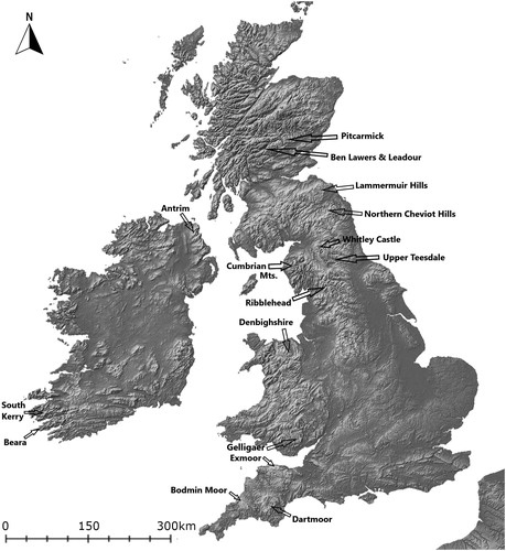
Fig 1 Topographic map showing the location of areas and sites mentioned in the text. Map by author.
RURAL ‘MARGINALITY’ CRITIQUED
If increasing availability of data has enabled this article’s new comparative approach to upland colonisation, reassessments of rural ‘marginality’ have also helped to justify it at a conceptual level. A fundamental critique was offered in 1989 by agrarian historian Mark Bailey,Footnote26 who used medieval East Anglian landscapes to question assumptions found in the work of Annales’ historian Georges Duby, and especially in Michael Postan’s ‘population-resources’ model.Footnote27 In their scholarship, places that were not ideal for growing cereal crops would only have been settled as a last resort, due to population pressure in the 12th and 13th centuries, and would then have been the first to fail when crisis hit the agrarian economy. Bailey, however, pointed out that while East Anglia’s sandy Brecklands might well be categorised as marginal arable land, these landscapes were not necessarily marginal for the local population. They allowed Brecklands communities to diversify into sheep and rabbit rearing, and to exploit non-agrarian resources in the fen and heath. In fact, Bailey argues that such diversification made their economy more resilient during the 14th century, when other regions felt the effects of a contracting grain market.
Archaeologists have built on this work further, showing that ‘marginality’ is subjective and depends on one’s social, economic or environmental perspective.Footnote28 In fact, Eva Svensson and Mark Gardiner have argued that Bailey’s critique is still rather narrow or ‘formalist’, in that it assesses marginality in terms of how efficiently people interacted with markets (ie their return on investment of labour).Footnote29 They argue that this cannot be a fair assessment of any rural community’s rationality, given that it ignores a host of social and cultural motivations for using a landscape.
To some extent, this is a problem of the historical record: the detailed manorial and monastic records which medieval agrarian historians tend to rely upon are often unavailable for uplands and other ‘marginal’ landscapes. Recent research on transhumance shows how a combination of ethnography, place names and landscape archaeology can be used to reconstruct the importance of ‘marginal’ places in medieval and post-medieval Europe. Summer farms and herding sites are now seen as a sophisticated adaptation to the peculiarities of living in or next to uplands and forests, allowing farmers who were based on relatively small areas of cultivable land to exploit large tracts of seasonally productive rough grazing around them.Footnote30 Indeed, some of this research has shown that herding livestock in common pastures facilitated the (re)production of social ties between peasant families and provided a setting for the formation of female gender roles. For many rural communities, hills and mountains were thus of primary, rather than marginal, significance.
CONCEPTS AND REALITIES OF ‘UPLANDS’
Nevertheless, there remains a question mark over how ‘upland’ is actually defined in the landscape. In its most generic form, the term is used for any piece of ground that appears elevated in relation to adjacent land. It has been applied to the Broadlands of Norfolk which rise no more than 40 m ASL,Footnote31 to relict field systems in south-western Ireland lying between 80 and 180 m ASL,Footnote32 and finally to any land in Britain above the traditional definitions of 244 m (800 ft) and 305 m (1000 ft).Footnote33 Robert Silvester even argues that making any precise definition of ‘upland’ based on altitude can be misleading, citing the fact that in Wales today, enclosed farmland often stretches up beyond the 244 m contour.Footnote34 As such, he implies that certain forms of land use, particularly post-medieval enclosure and improvement, may bring a hill or mountain’s status as ‘upland’ into question — those in-use farmhouses and fields giving the place a more domesticated appearance, similar to lowland regions. To Silvester, the ‘real’ uplands are those which lay above or beyond the limit of improved pasture and cultivation, ‘where traces of human activity from the past lie relict in the landscape.’Footnote35 Essentially, this means any relatively elevated tract of unenclosed common or waste where archaeological ‘lumps and bumps’ might await discovery under rough grass, bracken or heather.Footnote36 Thus, when defining uplands for research purposes, many archaeologists now seem to count historic character and appearance as much as altitude. ‘Uplands’ are increasingly understood as a mutable cultural construct, with environmental meaning secondary.
There is much to recommend this elastic approach given that pre-modern farming activity was never determined by the contours we see on maps today. Traditionally, there have been many different perceptions of what counts as upland. Along the western coast of Ireland, for example, even the unenclosed rough grazing found on low inland hills (in some cases only 50 to 100 m ASL) was referred to as sliabh, literally ‘mountain’, in the 1930s and 1940s.Footnote37 Similarly, the word mynydd in Wales can refer not only to a mountain or large hill, but also to common unenclosed lands more generally.Footnote38 Indeed, as the geographer Roderick Peattie remarked in 1936, ‘To a large extent…a mountain is a mountain because of the part it plays in the popular imagination.’Footnote39
The term ‘upland’ will no doubt remain convenient and commonly used. But archaeologists and historians must be careful not to lose sight of the real challenges which using land at higher altitudes could involve.Footnote40 For instance, the hill and mountain pastures that people relied upon for transhumance were often feared as liminal places, prone to supernatural occurrences. These beliefs were rooted in the reality of herding livestock in such places: cattle might get stuck in boggy ground, a herder might break an ankle in poor weather, or young dairymaids might be ‘abducted’ by strange men.Footnote41 The experiences of farmers who sought to live at higher altitudes all year round are even more illustrative. In contrast to the seasonally resident herders and dairymaids who moved down to lower slopes and valleys after October, these people had to contend with a number of issues.
Firstly, most soils above 250 m ASL in Ireland and western and northern Britain are acidic and peaty, making them low in available nutrients and poor at fixing nitrogen.Footnote42 Palaeoecological coring in northern Britain shows that peat formation initiated on mountain plateaux as early as 3800 bc,Footnote43 with a largely open landscape of peat and peaty podzolic soils characterising most hill and mountain slopes by the mid-1st or early 2nd millennium ad.Footnote44 Secondly, these environments receive substantially more rainfall than their lowland counterparts. Meteorological records for recent decades show that almost all land above 250 m receives a long-term average annual rainfall of more than 1500 mm (and on land above 350 m, the figure exceeds 2000 mm), compared to a lowland range of 750–1250 mm in Ireland and 550–1250 mm in Britain.Footnote45 Thirdly, steep altitudinal gradients in soil temperature would have affected plant growth. Modern data from northern England provide an indication: at 171 m ASL in Newton Rigg, Cumbria, not only did soil temperature at a depth of 300 mm reach 6 °C 1.5 months sooner than Widdybank Fell in Upper Teesdale (508 m ASL), it remained 4–5 °C higher than Widdybank Fell during the vital months of growth from March to August.Footnote46 None of these measurements can be used to gauge historical levels of rainfall and soil temperature, but what they illustrate clearly is the disparity in conditions between different altitudes. Regardless of time period, farmers were guaranteed to face delayed vegetation growth in spring and a reduced overall yield in autumn the higher they decided to settle. Researchers need to be far more aware and explicit about this altitudinal gradient if inter-site and inter-regional comparisons are to have any validity — the resilience of an ‘upland’ farm at 150 m or 200 m ASL is not the same as that of an ‘upland’ farm at 350 m ASL.
UPLAND SETTLEMENT IN SOUTH-WESTERN ENGLAND: EXPLOITING HUMAN NICHES IN A ‘BOOM’ PERIOD
In light of such challenges, the idea that climate shifts might play a role in farmers’ decisions to settle and cultivate higher ground is not unreasonable. While an altitudinal gradient in soil temperature would have remained, a warming climate would have increased the likelihood of soils above 200 and 300 m ASL reaching 6 °C at an earlier stage in the year, thereby making successful cereal cultivation more realistic. The Medieval Climatic Anomaly is an obvious candidate. Although not as uniform as previously assumed, it did see multi-annual or even multi-decadal increases in temperature between roughly ad 850 and 1300.Footnote47 However, the timing and extent of upland colonisation requires careful assessment before discussing the possibility of climatic factors.
Dartmoor, Exmoor and Bodmin Moor in south-western England have attracted more archaeological investigation than any other ‘marginal’ lands in Britain or Ireland. The boundaries of these moorland commons have fluctuated significantly, but even from a historical perspective they lie safely above 200 m ASL, with much of Exmoor and most of Dartmoor lying over 300 m. These landscapes seem to have been exploited on a seasonal transhumant basis in the early medieval period,Footnote48 with historical references, place-name and pollen evidence suggesting that year-round agrarian settlements were being established by the 10th and 11th centuries.Footnote49 While some of these pre-Norman farms were at lower altitudes around the fringes, and continue to be occupied today, some abandoned examples like Bunning’s Park and Brown Willy in Bodmin Moor and Badgworthy in Exmoor are higher (270–300 m ASL).Footnote50 These sites have attracted archaeological investigation and typically feature one or more stone longhouses with enough associated fields of relict ridge and furrow to suggest that their occupants were trying to produce food for the whole year. Indeed, the well-known cluster of longhouses at Hound Tor in Dartmoor also features gardens and corn-drying kilns.Footnote51
In Dartmoor, where most excavation has taken place, the present evidence suggests that colonisation was relatively late. The primary occupation phases of longhouses excavated at Hound Tor, Dinna Clerks, Hutholes and Okehampton Park lie in the 13th century, and indeed some were occupied well into the 15th century and beyond.Footnote52 Much has been made of this in the debate on abandonment, with several scholars rightly critiquing the idea of a sudden climate- or plague-induced ‘retreat from the margins’.Footnote53 Yet we also need to reassess the process of colonisation, and one underestimated factor in the late establishment of these (excavated) Dartmoor sites may simply be their relatively high altitude — all of them lie between 290 and 335 m ASL. The fascination with abandonment means that fieldwork has been biased towards medieval farms at the highest elevations which are no longer occupied, ie the ‘real’ uplands. Were excavation to take place at less conspicuous sites on slightly lower enclosed slopes where people still live, it is not inconceivable that they would reveal farm-establishment dates which more closely match the Conquest-era farms in Bodmin and Exmoor. For example, Domesday records for 1086 point to the existence of several small agro-pastoral settlements up to 270 m in south-eastern Dartmoor, including Dunstone, Manaton and Stoke.Footnote54 Indeed, opposite Stoke, on the relict landscape of Holne Moor, it has been argued that the first phase of medieval agrarian settlement — lobe-shaped enclosures stretching from 270 to 350 m ASL — dates to before the Norman Conquest, although this has yet to be tested with excavation.Footnote55
The available historical and archaeological evidence for south-western England therefore suggests a drawn-out but nonetheless upward process of colonisation from the 10th to the mid-13th centuries. Since this timeframe corresponds fairly well with the Medieval Climatic Anomaly overall, it is possible that periods of warmer temperature facilitated the settlement and cultivation of land in the moors. However, the chronological resolution from the archaeological record is not yet fine enough to attempt correlations with specific multi-annual periods of warmer temperatures. In any case, if peasant farmers did reap the benefits of warmer weather for certain periods, there is still the more immediate issue of what actually triggered them to move onto moorland. One oft-cited ‘push’ factor is population pressure, and since there is evidence for increasing population in England and much of Eurasia during the Late Middle Ages,Footnote56 this may well have been influential. However, it would be overly simplistic to think people spilled over into the commons because they had no other choice — there may also have been ‘pull’ factors.
In this regard, it is worth returning to Hound Tor in Dartmoor. Excavations suggest that the longhouses were underlain by small sunken-floored structures which may have functioned as the seasonal dwellings of herders; indeed, pollen evidence from the area suggests an open pastoral landscape prior to the 13th century.Footnote57 There is admittedly much chronological uncertainty about these structural remains and it cannot be confirmed if the they are of the sunken-dwelling type found elsewhere in England during the middle Anglo-Saxon period.Footnote58 Certainly, there is not enough dating evidence to support Maurice Beresford’s hypothesis of turf-walled buildings rebuilt roughly every 30 years from the 8th century onwards.Footnote59 However, they do at least indicate a phase of activity — possibly transhumant in nature — prior to the longhouse phase.
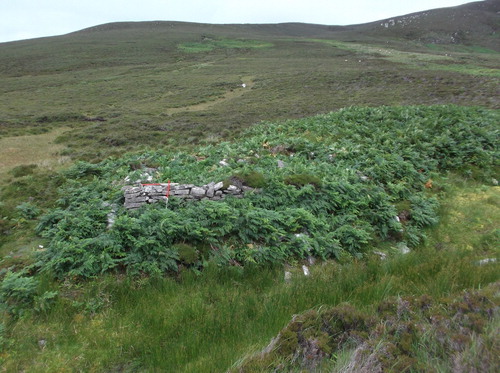
Regardless of whether the longhouses’ occupants ever witnessed this earlier phase of activity, the seasonal presence of people and livestock would likely have had a lasting local effect on the moor’s acid loamy soils and blanket peats. As previous research has shown, transhumance can transform certain patches of ground on upland commons.Footnote60 While the grazing of domesticated animals is well known to have general effects on the vegetation of uplands — for example, the 7th to 8th centuries saw more open pasture and possibly the use of fire in the low hills of Rackenford, south of Exmoor in Devon (200–250 m ASL)Footnote61 — it is also possible for discrete locations to be affected in a more intensive way by transhumance. In the dairy-based transhumance that was practised in early medieval south-western England,Footnote62 deposition of waste from the dairying process (buttermilk), dung from milking cows, and material from bedding and roofing may all have gradually raised both soil pH and levels of phosphorous and nitrogen around herders’ huts. The legacy of similar processes are often visible in the vegetation around seasonal herding sites in Britain and Ireland that have not been turned into year-round farms, in that their soils support somewhat more palatable species like purple moor grass (Molinia caerulea) and mat grass (Nardus stricta). When human activity ceases altogether, the soils at summer hafods, shielings and booleys appear especially susceptible to colonisation by bracken (Pteridium aquilinum) ( and ).Footnote63 Indeed, in Sweden, where species-rich meadows developed at summer farms in the vast boreal forest, seasonal settlement has been described as a form of human niche construction.Footnote64
Fig 2 SW-facing view of abandoned post-medieval booley dwelling in Coolagarranroe, Galtee Mountains (Co Tipperary, Ireland), showing grassier vegetation and absence of heather. Photograph by author.
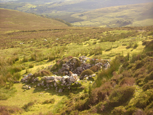
Fig 3 NW-facing view of abandoned post-medieval booley site in Mín na Saileach (Co Donegal, Ireland), with heavy colonisation by bracken. Photograph by author.
For the south-west of England, and elsewhere in Britain, I would argue that the prior existence of such anthropogenic niches has been underestimated as a factor in upland colonisation during the period. Archaeologists may have moved on from Postan’s simplistic population-resources model a long time ago, but there has still often been an assumption that wider socio-economic factors dictated when and why colonisation happened. In his re-evaluation of Hound Tor, Austin suggested that in expanding onto the ‘waste’, tenants were ‘exploiting…demographic growth, improved climate and a buoyant economy’, while Harold Fox’s book on Dartmoor describes it as ‘excellent testimony to pressure of population at that time.’Footnote65 Indeed, speaking generally about south-western England and Wales, Silvester asserts that the occupation and desertion of uplands was mainly governed by external trends.Footnote66 Wider trends in climate and population were undoubtedly significant, and the decisions of people at an elite level may well have proved to be a trigger for colonisation in many cases. For instance, in the Alps, historical records suggest that medieval colonisation of high-altitude valleys was mainly initiated by the landed aristocracy and the monasteries,Footnote67 and in some parts of post-medieval Ireland, landlords offered rental incentives to settle on and improve hilly ground.Footnote68
Crucially, however, the same historical evidence indicates that groups of medieval peasants in the Alps were also capable of leading colonisation, and in Donegal and Connemara it has recently been shown that the sons of tenant farmers actively selected upland booley sites for colonisation.Footnote69 In Sweden, too, summer fäbod sites might sometimes be settled on a year-round basis by young couples waiting for a farm of their own,Footnote70 while in Iceland, geoarchaeological investigation has demonstrated that pre-existing shieling sites could attract permanent occupation,Footnote71 possibly by landless young men.Footnote72 In each case, these settlers would have recognised the increased agricultural carrying capacity of seasonal sites based on the vegetation around them and, depending on their state of preservation, may have repurposed some pre-existing architecture.
In south-western England, even if there were other forces pushing people to move, similar human niches would have formed an important facilitative factor in upland colonisation, offering locations of least resistance. This is not to say that every new upland farm was established at a pre-existing seasonal site — at Hutholes, for example, re-excavation could not find any preceding occupation.Footnote73 Rather, it highlights the role of seasonal sites in helping to structure a wider process of ‘landscape learning’. This concept has previously been advanced in relation to the colonisation of environments that were completely new to humans,Footnote74 but it also has relevance in the transition to year-round farming activity in uplands. For Dartmoor, Exmoor and Bodmin Moor, the combined historical and archaeological evidence points to a relatively long time-frame for colonisation, with farms being established at gradually higher altitudes from the 10th to the 13th centuries. It suggests a drawn-out process of landscape learning in which peasant farmers were gradually testing the carrying capacity of the moors, using seasonal sites as stepping stones. Familial rights of grazing and herding may have determined who settled particular sites, particularly if year-round settlement followed seasonal activity without a break. As the aforementioned analysis of early 19th-century Donegal shows, it was tenant families practising transhumance that led to the colonisation of hill pastures. However, since there is less chronological certainty about the succession from transhumance to year-round mixed farming in medieval south-western England, the most which we can argue is that niches resulting from seasonal activity provided an aid to colonisers in understanding the agricultural carrying capacity of soil in different parts of the uplands ().
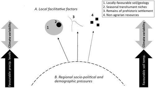
Fig 4 Illustration of the ‘pull’ and ‘push’ factors in upland colonisation in the 10th to 14th centuries, in the context of wider climate variability: A) local factors within uplands which acted as facilitative ‘pull’ factors for new hill farms; B) regional socio-political and demographic pressures which acted as ‘push’ factors for people to settle in uplands. Climate shifts which led to more favourable precipitation levels and soil temperatures increased the likelihood of these pull/push factors being acted upon. Drawing by author.
EMERGING EVIDENCE FOR EARLY MEDIEVAL UPLAND COLONISATION IN BRITAIN AND IRELAND
When we broaden the perspective out to the whole of Britain and to Ireland, the temporal correlation between upland colonisation and the population growth and temperature increases c 850–1300 becomes less clear. Indeed, many areas outside south-western England still only have tentative evidence of agriculture expanding upwards during this period. Among them is Ben Lawers in Highland Scotland, where structures located c 320 m ASL and dated to the 12th and 13th centuries have been interpreted as year-round dwellings based on their size, internal layout and the presence of rig and furrow.Footnote75 In Ireland, the only clear evidence comes from a large rectangular enclosure at c 275 m ASL in Tildarg (Co Antrim) which contains several house platforms occupied 1185–1375 cal ad.Footnote76 In Wales, although many archaeological features of historic settlement have been surveyed,Footnote77 a lack of excavation at potential hill farms over 250–300 m ASL hinders the drawing of solid correlations with the Medieval Climatic Anomaly. A notable exception is the small group of house platforms at almost 400 m ASL on Gelligaer Common (Gwent), which revealed late 13th- and early 14th-century occupation,Footnote78 though questions have since been raised about its status as a year-round settlement due to the lack of contemporary cultivation ridges and fields around them.Footnote79 Otherwise, scholars in Wales have had to rely on a mixture of field survey, historical inference and oral tradition, as at Cwm Pennant in Denbighshire, where Silvester argues that house platforms near the bottom of 65 ha of relict strip fields (which stretch up to almost 400 m ASL) represent either high-medieval or late-medieval encroachment onto lower mountain pasture.Footnote80 An early second millennium expansion onto lands over c 250 m ASL has been more reliably identified in northern England. Using documentary sources, Angus Winchester has traced the proliferation of peasant farms in various valleys and dales during the traditional boom period of the 12th and 13th centuries.Footnote81
However, there is also now sufficient archaeological and palaeoecological evidence from the north of England and the Scottish Borders to suggest a distinct earlier phase of colonisation on lands over 250 m. In Ribblehead, North Yorkshire, David Johnson has excavated two abandoned farmsteads on a hill slope called Brows Pasture. The lower farmstead at 265 m ASL yielded primary occupation dates ranging from ad 642 to 772 and the higher one at 285 m ASL yielded dates ranging from ad 763 to 895 ().Footnote82 A third abandoned farmstead at 340 m ASL in Gauber, Ribblehead, was given a terminus post quem in the mid- to late-9th century based on the excavation of a small coin hoard.Footnote83 In Bryant’s Gill (Kentmere, Cumbria), one of a number of possible house structures found within a small field system at 290 m ASL provided a radiocarbon date which I have calibrated to 649–968 cal ad at 95.4% probability (and 677–868 cal ad at 68.2% probability).Footnote84 Finally, in Upper Teesdale (County Durham, 351 m ASL), archaeobotanical and pollen evidence for cereal cultivation was found at the relatively large abandoned settlement of Simy Folds, which consists of four long sub-rectangular buildings each accompanied by one ancillary structure.Footnote85 IntCal 13 calibration of radiocarbon determinations from hearth charcoal gives the potentially early occupation date ranges of 666–978 cal ad and 687–992 cal ad (which at 68.2% probability come out at 692–892 cal ad and 772–962 cal ad).Footnote86 Moving north, pollen records from the northern Cheviot Hills of Scotland and the border area as a whole suggest an expansion of arable farming in the uplands in the 6th and 7th centuries.Footnote87 There are growing indications from Highland pollen records too that hill slopes were being settled and cultivated from the 7th century.Footnote88 Two distinctive byre-houses at Pitcarmick in north-eastern Perthshire (355 m ASL) offer the best archaeological example of this phase, given their primary occupation dates of 680–870 and 680–890 cal ad.Footnote89
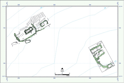
Fig 5 Plan of excavated early medieval hill farms in Brows Pasture, Ribblehead. Taken from Johnson Citation2015, fig 3, reproduced by kind permission of Dr David Johnson.
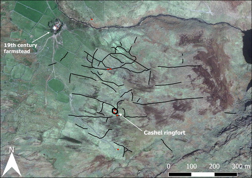
A broadly comparable pattern is starting to emerge in Ireland, particularly in the north-east and south-west, where archaeological fieldwork has been concentrated historically. At Ballyutoag, Co Antrim, the excavation of three circular/oval houses within a complex of curvilinear enclosures and fields which contain cultivation ridges provided radiocarbon dates ranging from the late-7th to the 10th centuries.Footnote90 More recent and systematic landscape research in western Cork even suggests a degree of continuity from late prehistory, with relict field systems in Barrees Valley laid out largely during the early-to-mid-1st millennium ad, and two small stone houses set among them dating to the 7th/8th and 11th/12th centuries, respectively.Footnote91 This evidence is admittedly found on relatively clement coastal slopes of only 80–180 m ASL. However, ongoing fieldwork in the neighbouring peninsula of Iveragh, Co Kerry, suggests that a year-round agricultural population — albeit less dense — was also a reality at higher inland locations during the mid-to-late 1st millennium, based on the discovery of a characteristic early medieval cashel and associated field boundaries at 250 m ASL in Cloon West, Glencar ().
Fig 6 Preliminary map of previously unrecorded archaeological features surviving upslope of an in-use hill farm in Cloon West (Co Kerry, Ireland). Red dots mark hut sites, and black lines mark relict walls. Map by author, satellite image data by Google Earth, Maxar Technologies.
What caused people to colonise such high ground during what many have described as a Late Antique Little Ice Age or Dark Ages Climatic Deterioration,Footnote92 that is to say, one, two or even three centuries before the ‘classic’ period of expansion from the 900s up to c 1300? Providing some geographical context for the evidence is a first and necessary step. Regardless of definition, ‘uplands’ clearly account for a greater percentage of the land area in northern Britain than in south-western England. As such, they are likely to have accumulated a more diverse record of human activity over time and, with that, been subject to a potentially wider range of push and pull factors. In this light, it is no surprise that one popular way of framing the discussion at the aforementioned sites in northern Britain has been that they represent political or cultural expansion. When discussing the pollen evidence for cereal cultivation in the Scottish Borders, Richard Tipping deliberated on whether Anglian expansion northwards after ad 600 contributed to the increase of upland farming. However, the date ranges from archaeological contexts are too late to relate directly to Anglian expansion, and in any case, it cannot have played a role in Cumbria or the dales of North Yorkshire. Thus, for these areas, there has been speculation that the excavated farmsteads, particularly Gauber (North Yorkshire), suggest Norse expansion into rural areas.Footnote93 Even the Pitcarmick byre-houses have been proposed as ‘evidence for direct or indirect [Pictish] adaptation’ of a longhouse style common in Jutland, the Rhineland and the Netherlands.Footnote94
ENVIRONMENTAL CONTEXT AS AN EXPLANATORY FRAMEWORK
In reality, it is risky to start interpreting these farmsteads in terms of migration and political power given the complete lack of biomarkers that might speak to ethnicity and the absence of rich cultural assemblages and specific historical references. It also distracts from the more fundamental issue of why their occupants were, as farmers, living there at all. Looking at the landscapes around these sites, we can say more about the micro-scale agrarian motivations behind this early phase of expansion, and about farmers’ adaptation to upland environments, than we can about ethnicity or cultural identity. For example, one factor enabling upland colonisation in the Yorkshire Dales may have been geology. All three of the farmsteads in Ribblehead lie on or next to karst limestone pavement which tends to give rise to alkaline soils that are inherently easier to cultivate than peaty acidic ones where nutrients like phosphorous, calcium and magnesium are limited. Furthermore, the higher the altitude of a farmstead the later in date it was, suggesting that the colonising farmers were engaged in a process of landscape learning similar to their later counterparts in south-western England. Indeed, a small structure found at an altitude of 380 m in the ‘Upper Pasture’ of nearby Horton produced an occupation date of 660–780 cal ad and is thought to have functioned as a shieling hut.Footnote95 This supports the hypothesis that transhumance was a pioneering activity which, unintentionally, paved the way for people who wished to settle uplands on a year-round basis.
A contextual reading of Simy Folds further emphasises the role of local environmental factors in facilitating or even attracting agricultural settlement. Besides their choice of a small limestone terrace, the early medieval occupants of Simy Folds established their farmsteads within easy reach of upland iron-ore deposits and exploited them on a semi-industrial scale.Footnote96 The presence of iron ore may also have been a contributory factor in the early medieval agricultural presence at Bryant’s Gill in Cumbria, where slag was retrieved.Footnote97 There are international parallels for this too; in the Norway/Sweden border area, iron production and trapping are known to have formed integral parts of the upland agrarian economy at various times over the 1st and early 2nd millennium ad.Footnote98 At some upland sites in Britain and Ireland, episodes of settlement and farming during late prehistory may also have facilitated later upland colonisation. Human occupation and manuring of the land would have increased phosphorous and nitrogen levels in the soil and raised its pH slightly, thus making it easier to cultivate for subsequent generations. Visible traces of older dwellings and field enclosures may have even helped medieval farmers to rationalise their colonisation efforts — providing reassurance that these places were indeed habitable. For instance, the Simy Folds farmsteads were established within a prehistoric field system and the Pitcarmick byre-houses were built on a shelf which contained late Bronze-Age roundhouses.Footnote99 In south-western England, the late Saxon/Norman landscape at Holne Moor clearly overlies a system of Bronze-Age reaves.61 As outlined above, there is also the possibility of outright continuity from the early 1st millennium ad in the hills of peninsular western Cork and Kerry. Thus, I would argue that a combination of locally favourable environmental conditions, desirable natural resources and the recognition/continuation of previous human activity can begin to explain this previously underestimated phase of early medieval upland farming. Furthermore, there is still some debate about how long the late antique Little Ice Age actually lasted. The latest end date is said to be c ad 660,Footnote100 and some palaeoclimatologists have even argued that Eurasian temperatures were recovering as quickly as a few decades after the major volcanic activity of the late 530s and 540s.Footnote101
Conversely, most of the above sites ceased to be occupied as year-round farms relatively early in the medieval period, ie either before the end of the 1st millennium ad or not long after. In northern England, the Brows Pasture farmsteads are estimated to have been given up well before the Norman Conquest, while Bryant’s Gill is not mentioned as a farm in any of the historical records available after the 10th century.Footnote102 At Simy Folds, cereal cultivation and the use of enclosures seems to have ceased in the decades c 1200.Footnote103 The argument that William I’s ‘Harrying of the North’ in 1069–70 freed up fertile lowland ground for the occupants of upland farms to move down into and claim is superficially attractive.Footnote104 However, the evidence for deliberate devastation at this time is not entirely clear. While some pollen records in County Durham and Cumbria suggest disruption to land use in the late 11th and early 12th centuries, the archaeology of village development remains inconclusive on the issue.Footnote105 Furthermore, the long chronological span of abandonment at the upland sites runs counter to the idea of a sudden downward movement after 1069–70. In any case, the phenomenon of abandonment was not limited to northern England’s harried lands — Pitcarmick in Scotland and upland sites in north-eastern and south-western Ireland also underwent at least temporary abandonment in the late 1st millennium ad.Footnote106
An evaluation of all potential socio-political influences in abandonment is beyond the scope of the present paper, but the role of local environmental change in decisions to continue farming (or not) in upland landscapes is coming into view. For example, while limestone geology might have improved prospects for colonisation in some parts of Ribblehead, the soils over karstic limestone can also be quite shallow and free-draining, and therefore liable to wash down grikes or fissures in the limestone when cleared of trees for cultivation.Footnote107 In fact, palaeoenvironmental studies from the north of England and Scotland’s southern uplands show increased slope and river-channel instability from the 6th to 12th centuries, including in the Howgill and Bowland Fells which lie to the north and west of Ribblehead.Footnote108 When combined with storm and flood events, year-round farming may have generated negative environmental feedback which contributed to these sites’ relatively early abandonment. In Ireland, there is some evidence of mineral soil eroding in the Barrees valley, Cork, during the period c 400–600.Footnote109 Generally, however, expansion of blanket peat seems to have been the more widespread issue in early medieval Irish uplands. At several locations in the peninsular hills of Cork and Kerry, and in Antrim, palaeoenvironmental analyses have shown that widespread peat expansion only began after the 7th or 8th centuries AD,Footnote110 and this is also suggested at Cocklawhead in the northern Cheviot Hills of Scotland.Footnote111
While farmers may have contributed to soil leaching and acidification by clearing trees and cultivating the ground, there is little doubt that a long-term driver of peat build-up and expansion in this period was wetter climatic conditions (causing waterlogging and reduced decomposition of plant remains). Across Ireland and northern Britain, records of peat surface wetness attest to particularly wet conditions from the 530s until at least the 9th century, with the dry climate of the Roman Warm Period not seen again during the Middle Ages.Footnote112 This is therefore a prime example of why temperature is not the only climatic factor that might affect land use. Regional levels of precipitation are also crucial and have potentially long-term consequences for the soils that farmers depend upon. Thus, while recent reviews of lowland pollen records in Britain and Ireland have argued that climate shifts were not a significant cause of social and landscape change in the 1st millennium ad,Footnote113 it was clearly still a possibility in uplands prone to peat formation.
SOCIO-ECONOMIC NEEDS VERSUS CLIMATE IN THE LATE MEDIEVAL AND EARLY MODERN PERIODS
Trends like erosion and peat expansion may have tipped the balance in favour of abandonment in some early medieval contexts, but they did not rule out upland agriculture in later periods. As precipitation levels eased somewhat after the 9th century and rural population grew, a new phase of agrarian expansion was to take place in the uplands of northern England and southern Scotland.Footnote114 After this ‘classic’ phase of colonisation in the early second millennium ad, there is little doubt that uplands, just like lowlands, experienced some decline of human population and cereal cultivation due to the famines and plagues of the 14th century. The Anglo-Scottish borders region is a well-known, albeit extreme, case where regional warfare and raiding from the 13th to 17th centuries compounded these continent-wide problems and contributed to extensive abandonment of tillage land in the hills.Footnote115
In other areas, however, abandoned farmsteads and relict ridge and furrow have distracted archaeologists from those which actually survived. In addition to clear historical and archaeological evidence for the continued occupation of several upland farms in south-western England into the late medieval and early modern periods,Footnote116 there are many areas of northern England where upland agriculture and settlement is still present today. Continuity can be quite difficult to demonstrate archaeologically given the impracticality of excavating occupied settlements, but one strong candidate must be Whitley Castle in south-western Northumberland, where medieval ridge and furrow is found in association with 16th-century bastle houses and an 18th/19th-century farmstead that remains in use.Footnote117 Indeed, there is documentary and place-name evidence in Cumbria and the northern Pennines for outright growth, especially from the 15th century. As peasants settled permanently on former monastic or demesne-owned vaccaries, and transformed the remaining shieling sites into farms, they began to enclose adjoining areas of common pasture in order to boost the size of their holdings.Footnote118
Furthermore, cereal cultivation appears to have remained viable in the Late Middle Ages and beyond. Although Parry’s work has linked changes in the extent of upland agriculture to climate deterioration after 1250, he does admit that 12 out of a reported 27 13th/14th-century settlements in southern Scotland’s Lammermuir Hills actually survived beyond the year 1600, with almost 40% of the mapped ridge and furrow still in use in 1800.Footnote119 There is more concrete evidence for the persistence of cereal cultivation just over 50 km to the south in Bowmont Valley, Roxburghshire, in the northern Cheviot Hills. Since this is a more uneven and challenging landscape for ploughing than the gently sloping hillsides of the Lammermuirs, it does not feature such large expanses of broad-rigged cultivation; nevertheless, there are enough hectares of rigs as to suggest year-round human habitation.Footnote120 In Bowmont Valley, the pollen record from Sourhope at 310 m ASL provides evidence of cereal cultivation including oat or wheat from c 1100 up to c 1675, while Swindon Hill (365 m ASL) indicates the same for c 1150–1300 and then again after c 1475. A third site with slightly less definite pollen evidence — Cocklawhead — suggests cereal cultivation above 500 m ASL from the end of the 15th century until modern times, including some rye after c 1500. In fact, only one of the sites sampled above 300 m ASL in the Bowmont Valley did not have good evidence for medieval cultivation.Footnote121 Recent fine-temporal pollen analysis of the abandoned farmstead of Leadour (350 m ASL) in Perthshire, Highland Scotland, also demonstrates continued barley cultivation and pasture from c 900 through to modern times, notwithstanding some woodland regeneration from 1400 to 1630,Footnote122 while studies from upland Wales support the idea that cereal-type pollen does not necessarily disappear from the record after the 13th century.Footnote123 The sustained presence of cereal cultivation at such high altitudes is remarkable and, at first glance, supports Tipping’s thesis that the late medieval and early modern Little Ice Age was not severe enough to leave upland cereal production in a vulnerable position.Footnote124
Yet the pollen record cannot tell us how quickly grain ripened or how much of a crop was harvested; it simply tells us that cereal-type plants were in the vicinity and reached the reproductive stage. Conversely, then, the continuation and expansion of year-round farming at the above locations is not proof that climate deterioration failed to affect the arable carrying capacity of upland soils. One important variable which palaeoenvironmental studies sometimes overlook is the adaptability of people in relation to historical events and trends. For instance, the early modern period saw Britain’s urban populations demand more beef and grain, thus presenting farmers in the northern Cheviot Hills with an economic opportunity.Footnote125 However, they also had to contend with increased surface wetness in local soils after c 1400 ad,Footnote126 and a cooler climate after c 1500.Footnote127 In order to tap into the markets, the increasing population of peasant farmers may therefore have had to give over many of their more fertile lower slopes to surplus cattle and grain production, while relying increasingly on less-desirable patches of mountain ground for their own subsistence needs.
There is no more glaring example of socio-economic needs overriding wider climatic trends than the massive colonisation of Ireland’s hills and mountain valleys in post-medieval times. Ireland experienced relatively wet summers from the late 1740s to the 1790s,Footnote128 and the Little Ice Age entered a second major dip at the start of the 19th century.Footnote129 Nevertheless, with the introduction of the potato in the 17th century, non-elite tenant farmers were able to produce more food per hectare than before, allowing the population to soar — particularly from the 1750s to 1845, when it rose from around 3 million to 8.5 million.Footnote130 This was largely rural population growth, and much of it was located on what had been rough upland pasture (). Unfortunately, the comparative value of this process for medieval phenomena has been overlooked due to academic focus on the subsequent Great Famine (1845–50). However, upland abandonment was neither wholesale nor immediate after the famine and, more importantly, tenant farmers had been able to colonise vast swathes of acidic podzols and blanket bog in a period of unfavourable climatic conditions.Footnote131
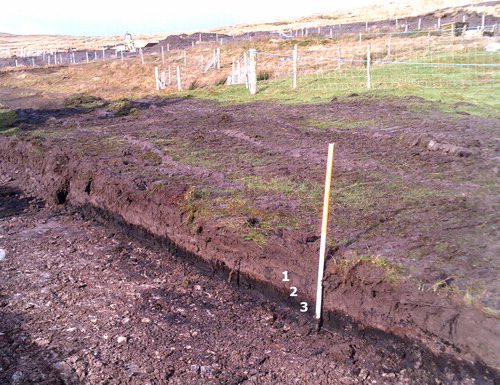
Fig 7 NW-facing view of test trenching in Coolnagoppoge (Co Kerry, Ireland) (see Murphy and Costello Citation2019; excavation license: 16E0127). The site is in an area of hilly blanket bog (c 290 m ASL) which was colonised by tenant farmers in the late 18th or early 19th century. The section consists of, from top to bottom: (1) a greyish-brown sandy silty clay likely created by farmers with burnt lime, livestock dung and sand from nearby streambeds, (2) a very thin iron pan, and (3) a buried dark-brown peat layer which pre-dates the colonisation. Photograph by author.
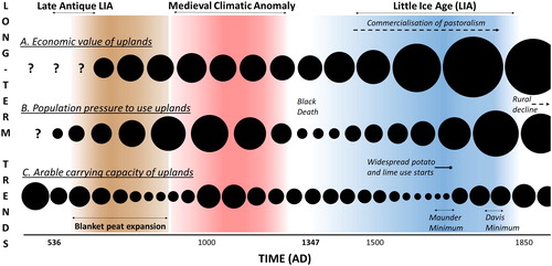
In Ireland, when a revolutionary new crop, technological advances in making lime, and occasional rental incentives from landlords were combined with the pressure of needing to find and cultivate enough land to sustain a nuclear family, climate change was simply not harsh enough to halt the multi-decadal trend of agricultural expansion. It was a constant background factor which could limit or enhance the carrying capacity of landscapes that were already disadvantaged in terms of soil temperature and acidity, and it had the potential to induce short-term disaster through extreme weather events. However, in the temperate oceanic conditions of Ireland and Britain prior to the 20th century, it could be overridden at multi-annual or multi-decadal timescales by powerful convergences of demographic pressure, economic demand, and alteration of soil properties with innovative crops and techniques. provides a hypothetical illustration of how these trends may have combined to influence the viability of upland farms in the long term.
Fig 8 Hypothetical summary of three key long-term trends that influenced decisions to establish year-round farms in uplands and influenced the viability of these farms once established (c ad 500–1900): A) the economic value of uplands; B) population pressure to settle in uplands; and C) arable carrying capacity of uplands. Circle sizes are estimations of the relative strength of each influencing factor at a particular point in time; ie the larger the circle, the greater the economic value, population pressure to settle, or arable carrying capacity of uplands. Drawing by author.
CONCLUSION
Building on the steady progress of archaeology and palaeoecology in hilly regions in Britain and Ireland over recent decades, this article has sought to initiate a comparative discussion on upland colonisation during the Middle Ages. The timing and extent of agricultural expansion into such landscapes remains poorly understood in this part of Europe and, with further study, may offer lessons about the adaptability of farmers in a temperate oceanic context. Examining agricultural communities’ need to adapt should not stoke fears of environmental determinism. On the contrary, if we admit that farmers faced certain challenges when settling in hilly and mountainous terrain on a permanent basis, we can begin to build a more realistic conceptual framework of their agency in colonisation. However, archaeologists need to be clearer about the local environmental context of different hill farmers if we are to fully understand their agency in relation to wider socio-economic and climatic trends. Even in the temperate oceanic climates of Ireland and Britain, there are significant altitudinal gradients in rainfall and soil temperature. Discussions on the establishment and resilience of agrarian settlements simply cannot afford to ignore these factors.
The establishment of year-round farms at higher altitudes on the moorlands of south-western England between the 10th and 13th centuries introduces the analytical value of a ‘glocal’ approach. Globally or regionally, population rise may have increased demand for land, and the combination of warmer temperatures with slightly reduced levels of precipitation would have eased the challenge of cultivating higher ground. Locally, however, the gradual ‘climb’ of farms suggests that multi-generational processes of landscape learning via transhumance and the creation of anthropogenic niches provided additional facilitative factors in upland colonisation. Of course, since ‘upland’ terrain can vary, this glocal approach almost by definition requires a comparative perspective — an area where research on medieval upland farming has not been particularly strong to date.
While significant amounts of archaeological and palaeoecological data have been gathered outside the south-west of England, in the northern Pennines and the Scottish Borders, and to a lesser extent in the Scottish Highlands and Ireland, they have not been brought together and analysed in detail at an inter-regional/international level. By broadening the horizon accordingly, this article has shown that there is now a strong argument across the two islands for a phase of early medieval upland colonisation that is invisible in the documentary record. This phase of activity ought to form an important ‘sandpit’ of debate for archaeologists in the years ahead, as it forces us to look more critically at the role of climatic shifts in agricultural expansion. Global temperatures may not have recovered until c ad 660, well after volcanic activity in the late 530s, and there is clear evidence for increased precipitation in northern Britain and Ireland during the mid- to late-1st millennium ad. There may be justification for thinking that agrarian colonisation took place before widespread peat expansion in some areas, and — perhaps in northern Britain — that particular ethno-political groups were hoping to assert control over blocks of upland by settling strategic valleys. However, examination of the environmental context of key sites again points to hidden local factors, such as favourable geology, the availability of non-agrarian resources, or an antecedent cultural landscape due to previous or continued settlement from late prehistory. This makes for a timely counterpoint to the idea that it was mainly external factors which were responsible for the colonisation and desertion of uplands.Footnote132 It also raises the possibility — for all rural environments — that large-scale computational modelling may be hindered by externalist or top-down explanations of agricultural change if local variables are not sufficiently recorded and accounted for in future research.
External factors were undoubtedly important, especially considering that the growth of market demands and, later on, the introduction of potatoes and liming, had a role in negating the potentially deleterious influence of the Little Ice Age on upland agriculture. Yet the primary agents of this mitigation were the non-elite peasant farmers on the ground who had to work with the soil, the weather and negotiate through socio-political structures on an everyday basis. It is all too easy to take their active resilience for granted when it is approached from the longue durée perspective of a landscape archaeologist, and especially when field research focuses on the hill farms which now lie abandoned. The most logical first question for anyone interested in the rationality of medieval land use should not be to enquire what wider trend caused people to leave these places, but rather to ask how they attracted and retained farming activity. The environmental realities of uplands must be embraced in order to truly contest their marginality.
Acknowledgments
I would like to thank Dr Mark Gardiner, Lincoln University, for his advice during my initial research on northern England and Dr Richard Tipping, Stirling University, for discussing medieval and later agriculture in the Scottish Highlands with me. I wish to thank the people of Glencar and Black Valley, particularly Ms Coffey in Cloon West, for their patience as I continue fieldwork in south Kerry. Con Moriarty of Dunloe has been especially generous with local knowledge. This research is published with financial assistance from Stockholm University, where I was employed as a postdoctoral fellow for the ‘Environmental Research in the Human Sciences’ initiative. It was also supported by a grant from the Albert and Maria Bergström Foundation in 2019. Lastly, I thank the editor and two anonymous reviewers for their constructive comments.
Notes
2 Eg Darvill Citation1986; O’Brien Citation2009.
3 Feacham Citation1973; Fleming Citation1978; Spratt and Burgess Citation1985.
4 Eg Ward Citation1993; Atkinson Citation2016.
5 Eg Austin Citation1978; Beresford et al Citation1979; Coggins et al Citation1983; Gent Citation2007; Johnson Citation2012.
6 Eg Williams Citation1984.
7 O’Brien Citation2009.
8 Eg Lynch Citation1981; Caseldine Citation2006; O’Brien Citation2009, 285–322; Tipping Citation2010; Davies Citation2016.
9 Coles and Mills 1998; Whyte and Winchester Citation2004; Roberts Citation2006; Turner and Young Citation2007; Klápšte and Sommer 2009.
10 See Gilchrist and Reynolds Citation2009; Gerrard and Gutiérrez Citation2018.
11 See Austin Citation1985; Rippon et al Citation2006; Roberts Citation2006; Silvester Citation2010.
12 See RCAHMW’s Coflein database.
13 Campbell Citation2016, 348.
14 Parry Citation1975; 1978.
15 Tipping Citation2002; Caseldine Citation2006, 136–40; Coyle McClung and Plunkett Citation2020.
16 Bradley Citation2000; Bradley et al Citation2003.
17 Eg Horning Citation2011, 172; Atkinson Citation2016, 78, 94; see critique in Ljungqvist et al Citation2020.
18 See Brown Citation2018, 155.
19 Eg Aston et al Citation1989; O’Conor Citation1998; Atkinson et al Citation2000; Hamerow Citation2002; Christie and Stamper Citation2011.
20 Williamson Citation2013, 2.
21 Williamson Citation2013; Oram and Adderley Citation2008; Schreg Citation2014; Vésteinsson et al Citation2014; Costello Citation2017, 192.
22 Febvre Citation1932, 27.
23 Eg Fleming and Ralph Citation1982, fig 3; Austin and Thomas Citation1990, 65-72; Silvester Citation2000, fig 2.
24 Austin and Thomas Citation1990; Austin Citation2006.
25 Austin et al Citation1980; Caseldine Citation2006; Atkinson Citation2016.
26 Bailey Citation1989.
27 Duby Citation1962; Postan Citation1973.
28 Blaikie and Brookfield Citation1987, 20; Horning Citation2007, 375; Turner and Young Citation2007.
29 Svensson and Gardiner Citation2009, 22.
30 Fox Citation2012; Kupiec et al Citation2015; Costello Citation2020.
31 Williamson Citation1997, 9.
32 O’Brien Citation2009.
33 Darvill Citation1986; Silvester Citation2010, 141–2.
34 Silvester Citation2010, 142.
35 Ibid.
36 See Silvester and Kissock Citation2011, 159.
37 Eg National Folklore Collection, vol 62, 218; vol 156, 54; vol 157, 434.
38 Geiriadur Prifysgol Cymru, mynydd.
39 Peattie Citation1936, 4.
40 For an example of this environmentally ‘grounded’ thinking elsewhere, see Vésteinsson et al Citation2014.
41 Costello Citation2017, 190–191.
42 Newbould Citation1982, 103.
43 Tipping Citation2010, 195.
44 Fossitt Citation1994; Huang Citation2002, 163; Tipping Citation2010, 110, 116.
45 Walsh Citation2012; Meteorological Office 2019.
46 Green and Harding Citation1980, fig 7.
47 Mann et al Citation2009; Ljungqvist Citation2010.
48 Herring Citation2012; Gardiner Citation2018.
49 Rippon et al Citation2006, 52, 53; Faith Citation2012; Fox Citation2012.
50 Wilson-North Citation1999; Austin et al Citation1989; Herring Citation2006.
51 Beresford et al Citation1979.
52 Austin Citation1978; Beresford et al Citation1979; Allan Citation1994.
53 Austin Citation1985; Dyer Citation1989; Silvester Citation2010, 144–5.
54 Open Domesday, Dunstone <opendomesday.org/place/SX7175/dunstone/>; Manaton <opendomesday.org/place/SX7581/manaton/>; Stoke <opendomesday.org/place/SX6970/stoke/>.
55 Fleming and Ralph Citation1982.
56 Duby Citation1962; Postan Citation1973; Langdon and Masschaele Citation2006.
57 Beresford et al Citation1979; Austin and Walker Citation1985.
58 Fox Citation2012, 142–4; Gardiner Citation2018, 111.
59 Austin Citation1985.
60 Costello Citation2017; Gardiner Citation2018.
61 Rippon et al Citation2006, 52.
62 Fox Citation2012.
63 Hafod (Wales), shieling (northern Britain) and booley/buaile (Ireland) are local terms for summer transhumance sites; see Costello Citation2020, chs 1, 2.
64 Eriksson and Arnell Citation2017.
65 Austin Citation1985, 75; Fox Citation2012, 141.
66 Silvester Citation2010, 157.
67 Viazzo Citation1989, 59, 124.
68 Costello Citation2020, 118.
69 Costello Citation2020, ch 6.
70 Svensson Citation1998, 104.
71 Kupiec et al Citation2015, 217.
72 Vésteinsson et al Citation2014, 60-61.
73 Gent Citation2007.
74 Rockman Citation2012.
75 Atkinson Citation2016, 78–94.
76 Brannon Citation1984; UB-2581.
77 Browne and Hughes Citation2003; Roberts Citation2006; see also RCAHMW’s Coflein database.
78 Fox Citation1939.
79 Locock Citation2006, 55.
80 Silvester Citation2004, 55–7.
81 Winchester Citation2000a; Citation2000b.
82 Johnson Citation2015, tab 1.
83 King Citation2004, 340–3.
84 Dickinson Citation1985; HAR5944. Dates calibrated using OxCal 4.3, IntCal 13. A more complete site report has now been released and confirms the 7th–10th century dating (Dickinson 2020).
85 Coggins et al Citation1983.
86 Cogginset al Citation1983, 24; HAR4034, HAR1898. Dates calibrated using OxCal 4.3, IntCal 13.
87 Tipping Citation2010, 191.
88 Strachan, Sneddon and Tipping Citation2019, 138–142.
89 Carver et al Citation2012, tab 5; SUERC-36058, SUERC-36051.
90 Williams (Citation1984) argues that Ballyutoag was a summer transhumance village but recent research suggests it is far too complex and extensive a settlement for that; see Costello Citation2020, 43.
91 O’Brien Citation2009, 257–70.
92 Eg Blackford and Chambers Citation1991; Swindles et al Citation2009; Büntgen et al Citation2016.
93 Dickinson Citation1985; Batey Citation1995.
94 Carver et al Citation2012, 191.
95 Johnson Citation2012; SUERC-35384.
96 Coggins et al Citation1983, 19.
97 Dickinson Citation1985.
98 Svensson et al Citation2013; Stene and Wangen Citation2017, fig 9.8.
99 Carver et al Citation2012, illus 4.
100 Büntgen et al Citation2016.
101 Helama et al Citation2017.
102 Johnson Citation2015, 43; Dickinson Citation1985.
103 Coggins et al Citation1983, 23.
104 Winchester Citation2000a, 79.
105 Creighton and Rippon Citation2017, fig 4.3.
106 Carver et al Citation2012, 186; Williams Citation1984; O’Brien Citation2009, 257–70.
107 See the case of the Burren in Ireland, eg Jones Citation2016.
108 Cited by Tipping Citation2010, 192.
109 O’Brien Citation2009, 303.
110 Lynch Citation1981; Williams Citation1984; MacDonald et al Citation2005, 59; O’Brien Citation2009, 285–322.
111 Tipping Citation2010, 110.
112 Hendon et al Citation2001; Barber et al Citation2003; Tipping Citation2010, 191; Swindles et al Citation2013.
113 Rippon and Fyfe Citation2015; Coyle McClung and Plunkett Citation2020.
114 Davies and Dixon Citation2007, 42; Tipping Citation2010, 190–4.
115 See Davies and Dixon Citation2007, 42.
116 See Silvester Citation2010, 145–7.
117 Went and Ainsworth Citation2013.
118 Whyte Citation1985; Fleming Citation1998, 42–53; Winchester Citation2000a, 79–81.
119 Parry Citation1975, 5–6.
120 Unfortunately, the archaeological report on any associated occupation sites is yet to be published.
121 Tipping Citation2010, 115, 194, 199.
122 Davies Citation2016.
123 See Caseldine Citation2006, 144.
124 Tipping Citation2002; Citation2010, 199.
125 Adamson Citation2014.
126 Tipping Citation2010, 197.
127 Matthews and Briffa Citation2005; Mann et al Citation2009, fig 1; Owens et al Citation2017.
128 Murphy et al Citation2018.
129 Mann et al Citation2009, fig 1; Owens et al Citation2017, 3.
130 Mokyr and Ó Gráda Citation1984.
131 Bell Citation1998; Costello Citation2020, ch 6.
132 Silvester Citation2010, 157.
BIBLIOGRAPHY
- Adamson, D B 2014, Commercialisation, Change and Continuity: an Archaeological Study of Rural Commercial Practice in the Scottish Highlands (unpubl PhD thesis, University of Glasgow).
- Allan, J 1994, ‘Medieval pottery and the dating of deserted settlements on Dartmoor’, Proc Devon Archaeol Soc 52, 141–7.
- Aston, M, Austin, D and Dyer, C (eds) 1989, The Rural Settlements of Medieval England, Oxford: Blackwell.
- Atkinson, J A 2016, Ben Lawers: an Archaeological Landscape in Time, Scott Archaeol Internet Rep 62.
- Atkinson, J A, Banks, I and MacGregor, G (eds) 2000, Townships to Farmsteads: Rural Settlement in Scotland, England and Wales, Brit Archaeol Rep Brit Ser 293.
- Austin, D 1978, ‘Excavations in Okehampton Park, Devon, 1976–78’, Proc Devon Archaeol Soc 36, 191–240.
- Austin, D 1985, ‘Dartmoor and the upland village of the south-west of England’, in D Hooke (ed), Medieval Villages, Oxford: Oxford University, 71–9.
- Austin, D 2006, ‘The future: discourse, objectives and directions’, in Roberts, 193–205.
- Austin, D, Daggett, R H and Walker, M J C 1980, ‘Farms and fields in Okehampton Park, Devon: the problems of studying medieval landscape’, Landscape Hist 2:1, 39–57.
- Austin, D, Gerrard, G A M, and Greeves, T 1989, ‘Tin and agriculture in the middle ages and beyond: landscape archaeology in St Neot parish, Cornwall’, Cornish Archaeol 28, 5–251.
- Austin, D and Thomas, J 1990, ‘The ‘proper study’ of medieval archaeology: a case study’, in D Austin and L Alcock (eds), From the Baltic to the Black Sea: Studies in Medieval Archaeology, London: Unwin Hyman, 43–78.
- Austin, R and Walker, M J C 1985, ‘A new landscape context for Hound Tor, Devon’, Medieval Archaeol 29, 147–52.
- Bailey, M 1989, A Marginal Economy? East Anglian Breckland in the Later Middle Ages, Cambridge: Cambridge University Press.
- Barber, K E, Chambers, F M and Maddy, D 2003, ‘Holocene palaeoclimates from peat stratigraphy: macrofossil proxy climate records from three oceanic raised bogs in England and Ireland’, Quat Sci Rev 22:5–7, 521–39.
- Batey, C 1995, ‘Aspects of rural settlement in northern Britain’, in D Hooke and S Burnell (eds), Landscape and Settlement in Britain, ad 400–1066, Exeter: University of Exeter Press, 69–94.
- Bell, J 1998, ‘The spread of cultivation into the marginal land in Ireland during the 18th and 19th centuries’, in C M Mills and G Coles (eds), Life on the Edge: Human Settlement and Marginality, Oxford: Oxbow, 39–43.
- Beresford, G, Brandon, P and Linehan, C D 1979, ‘Three deserted medieval settlements on Dartmoor: a report on the late E Marie Minter’s excavations’, Medieval Archaeol 23:1, 98–158.
- Blackford, J J and Chambers, F M 1991, ‘Proxy records of climate from blanket mires: evidence for a Dark Age (1400 BP) climatic deterioration in the British Isles’, Holocene 1:1, 63–7.
- Blaikie, P and Brookfield, H (eds) 1987, Land Degradation and Society, London: Methuen.
- Bradley, R S 2000, ‘Climate paradigms for the last millennium’, Pages Newsletter 8:1, 2–3.
- Bradley, R S, Hughes, M K and Diaz, H F 2003, ‘Climate in Medieval time’, Science 302:5644, 404–5.
- Brannon, N 1984, ‘A small excavation in Tildarg townland, near Ballyclare, County Antrim’, Ulster J Archaeol 47, 163–70.
- Brown, P J 2018, ‘Coping with disaster’, in Gerrard and Gutiérrez, 154–68.
- Browne, D and Hughes, S (eds) 2003, The Archaeology of the Welsh Uplands, Cardiff: RCAHMW.
- Büntgen, U, Myglan, V S, Ljungqvist, F C, et al 2016, ‘Cooling and societal change during the Late Antique Little Ice Age from 536 to around 660 ad’, Nature Geosci 9:3, 231–6.
- Campbell, B M S 2016, The Great Transition: Climate, Disease and Society in the Late–Medieval World, Cambridge: Cambridge University Press.
- Carver, M, Barrett, J, Downes, J, et al 2012, ‘Pictish byre-houses at Pitcarmick and their landscape: investigations 1993–5’, Proc Soc Antiq Scot 142, 145–99.
- Caseldine, A 2006, ‘The environment and deserted rural settlements in Wales’, in Roberts, 133–53.
- Christie, N and Stamper, P (eds) 2011, Medieval Rural Settlement: Britain and Ireland, ad, 800–1600. Oxford: Oxbow.
- Coggins, D, Fairless, K J, Batey, C E, et al 1983, ‘Simy Folds: an early medieval settlement site in Upper Teesdale, Co. Durham’, Medieval Archaeol 27:1, 1–26.
- Costello, E 2017, ‘Liminal learning: social practice in seasonal settlements of western Ireland’, J Social Archaeol, 17:2, 188–209.
- Costello, E 2020, Transhumance and the Making of Ireland’s Uplands, 1550–1900, Woodbridge: Boydell and Brewer.
- Coyle McClung, L and Plunkett, G 2020, ‘Cultural change and the climate record in final prehistoric and early medieval Ireland’, Proc Roy Ir Acad, 120C, 1–30.
- Creighton, O and Rippon, S 2017, ‘Conquest, colonisation and the countryside: archaeology and the mid-11th- to mid-12th-century rural landscape’, in D Hadley and C Dyer (eds), The Archaeology of the 11th Century: Continuities and Transformations, London: Routledge, 57–87.
- Darvill, T 1986, The Archaeology of the Uplands: A Rapid Assessment of Archaeological Knowledge and Practice, London: RCAHME.
- Davies, A L 2016, ‘Flexibility in upland farming: pollen evidence for the role of seasonal pastures in the Scottish farm economy from ca. 1600–1900 ce’, in F Retamero, I Schjellerup and A L Davies (eds), Agricultural and Pastoral Landscapes in Pre-Industrial Society: Choices, Stability and Change, Oxford: Oxbow, 271–87.
- Davies, A L and Dixon, P 2007, ‘Reading the pastoral landscape: palynological and historical evidence for the impacts of long-term grazing on Wether Hill, Ingram, Northumberland’, Landscape Hist 29:1, 35–45.
- Dickinson, S 1985, ‘Bryant’s Gill, Kentmere: another ‘Viking-period’ Ribblehead?’, in J R Baldwin and I D Whyte (eds), The Scandinavians in Cumbria, Edinburgh: Scott Soc Northern Stud, 83–8.
- Dickinson, S 2020, ‘Bryant’s Gill: a Viking Age shieling-farmstead in the English Lake District and its wider contexts’, Bryant’s Gill Paper: Kentmere Archaeological Project, <www.academia.edu/44363414/Bryants_Gill_a_Viking_age_shieling_farmstead_in_the_English_Lake_District_and_its_wider_contexts> [accessed 15 October 2020].
- Duby, G 1962, L’économie rurale et la vie des campagnes dans l’occident medieval, Paris: Aubier, Éditions Montaigne.
- Dyer, C 1989, ‘“The retreat from marginal land”: the growth and decline of medieval rural settlements’, in M Aston, D Austin and C Dyer (eds), The Rural Settlements of Medieval England, Oxford: Blackwell, 45–57.
- Eriksson, O and Arnell, M 2017, ‘Niche construction, entanglement and landscape domestication in Scandinavian infield systems’, Landscape Res 42:1, 78–88.
- Faith, R 2012, ‘Some Devon farms before the Norman Conquest’, in Turner and Silvester, 73–88.
- Feacham, R W 1973, ‘Ancient agriculture in the highland of Britain’, Proc Prehist Soc 39, 332–53.
- Febvre, L 1932, A Geographical Introduction to History, London: Kegan Paul, Trench and Trubner.
- Fleming, A 1978, ‘The prehistoric landscape of Dartmoor part 1: South Dartmoor’, Proc Prehist Soc 44, 97–123.
- Fleming, A 1998, Swaledale: Valley of the Wild River, Edinburgh: Edinburgh University Press.
- Fossitt, J A 1994, ‘Late-glacial and Holocene vegetation history of western Donegal, Ireland’, Biol Env: Proc Roy Ir Acad 948, 1–31.
- Fleming, A and Ralph, N 1982, ‘Medieval settlement and landuse on Holne Moor, Dartmoor: the landscape evidence’, Medieval Archaeol 26:1, 101–37.
- Fox, A 1939, ‘Early Welsh homesteads on Gelligaer Common, Glamorgan’, Archaeol Cambrensis 94, 163–73.
- Fox, H S A 2012, Dartmoor’s Alluring Uplands: Transhumance and Pastoral Management in the Middle Ages, ed M Tompkins and C Dyer, Exeter: Exeter University Press.
- Gardiner, M 2018, ‘The changing character of transhumance in early and later medieval England’, in E Costello and E Svensson (eds), Historical Archaeologies of Transhumance across Europe, London: Routledge, 109–20.
- Geiriadur Prifysgol Cymru [A Dictionary of the Welsh Language], Centre for Advanced Welsh and Celtic Studies, National Library of Wales, <geiriadur.ac.uk/gpc/gpc.html> [accessed 8 December 2019].
- Gent, T 2007, ‘The re-excavation of a deserted medieval longhouse at Hutholes, Widecombe-in-the-Moor, Dartmoor’, Proc Devon Archaeol Soc 65, 47–82.
- Gerrard, C M and Gutiérrez, G L (eds) 2018, The Oxford Handbook of Later Medieval Archaeology in Britain, Oxford: Oxford University Press.
- Gilchrist, R and Reynolds, A (eds) 2009, Reflections: 50 Years of Medieval Archaeology, 1957–2007, London: Routledge.
- Green, F H W and Harding, R J 1980, ‘Altitudinal gradients of soil temperatures in Europe’, Trans Inst Brit Geogr 5:2, 243–54.
- Hamerow, H 2002, Early Medieval Settlements: The Archaeology of Rural Communities in North-West Europe, 400–900, Oxford: Oxford University Press.
- Helama, S, Jones, P D and Briffa, K R 2017, ‘Limited late antique cooling’, Nature Geosci 10:4, 242–3.
- Hendon, D, Charman, D J and Kent, M 2001, ‘Palaeohydrological records derived from testate amoebae analysis from peatlands in northern England: within-site variability, between-site comparability and palaeoclimatic implications’, Holocene 11:2, 127–48.
- Herring, P 2006, ‘Medieval fields at Brown Willy, Bodmin Moor’, in S Turner (ed), Medieval Devon and Cornwall: Shaping an Ancient Countryside, Macclesfield: Windgather, 78–103.
- Herring, P 2012, ‘Shadows of ghosts: early medieval transhumants in Cornwall’, in Turner and Silvester, 89–105.
- Horning, A 2007, ‘Materiality and mutable landscapes: rethinking seasonality and marginality in rural Ireland’, Int J Histor Archaeol 11:4, 358–78.
- Horning, A 2011, ‘Ireland: medieval identity, settlement and land use’, in Christie and Stamper, 172–85.
- Huang, C C 2002, ‘Holocene landscape development and human impact in the Connemara Uplands, Western Ireland’, J Biogeography 29:2, 153–65.
- Johnson, D 2012, Excavation of an Early Medieval Structure in Upper Pasture, Horton in Ribblesdale, North Yorkshire, Ingleton: Ingleborough Archaeol Group, <www.ingleborougharchaeologygroup.org.uk/pdfs/UP11web.pdf> [accessed 24 April 2019].
- Johnson, D 2015, ‘Chapel-le-Dale, North Yorkshire: the making of an upland landscape’, Landscape Hist 36:1, 25–45.
- Jones, C 2016, ‘Dating ancient field walls in karst landscapes using differential bedrock lowering’, Geoarchaeol 31:2, 77–100.
- King, A 2004, ‘Post-Roman upland architecture in the Craven Dales and the dating evidence’, in J Hines, A Lane and M Redknap (eds), Land, Sea and Home: Proceedings of a Conference on Viking-Period Settlement, London: Routledge, 335–44.
- Kupiec, P, Milek, K, Gísladóttir, G A et al, 2015, ‘Elusive sel sites: the geoarchaeological quest for Icelandic shielings and the case of Þorvaldsstaðasel, in northeast Iceland’, in J Collis, M Pearce and F Nicolis (eds), Summer Farms: Seasonal Exploitation of the Uplands from Prehistory to the Present, Sheffield: J R Collis, 211–24.
- Langdon, J and Masschaele, J 2006, ‘Commercial activity and population growth in medieval England’, Past & Present 190:1, 35–81.
- Ljungqvist, F C 2010, ‘A new reconstruction of temperature variability in the extra‐tropical northern hemisphere during the last two millennia’, Geografiska Annaler: Ser A, Phys Geogr 92:3, 339–51.
- Ljungqvist, F C, Seim, A and Huhtamaa, H 2020, ‘Climate and society in European history’, WIREs: Climate Change e691.
- Locock, M 2006, ‘Deserted rural settlements in south-east Wales’, in Roberts, 51–5.
- Lynch, A 1981, Man and environment in South-West Ireland, 4000 bc–ad 800: a study of man’s impact on the development of soil and vegetation, Brit Archaeol Rep Brit Ser 85.
- MacDonald, P, Carver, N and Yates, M 2005, ‘Excavations at McIlwhans Hill, Ballyutoag, County Antrim’, Ulster J Archaeol (3rd ser) 64, 43–61.
- Mann, M E, Zhang, Z, Rutherford, S, et al 2009, ‘Global signatures and dynamical origins of the Little Ice Age and Medieval Climate Anomaly’, Science 326:5957, 1256–60.
- Matthews, J A and Briffa, K R 2005, ‘The ‘Little Ice Age’: re‐evaluation of an evolving concept’, Geografiska Annaler: Ser A, Phys Geogr 87:1, 17–36.
- Meteorological Office 2019, UK Climate Averages <www.metoffice.gov.uk/public/weather/climate/> [accessed 25 April 2019].
- Mokyr, J and Ó Gráda, C 1984, ‘New developments in Irish population history, 1700–1850’, Econ Hist Rev 37:4, 473–88.
- Murphy, C, Broderick, C, Burt, T P, et al 2018, ‘A 305-year continuous monthly rainfall series for the island of Ireland (1711–2016)’, Clim Past 14:3, 413–40.
- Murphy, D and Costello, E 2019, Grousemount Wind Farm, Kilgarvan, County Kerry: Final Archaeological Report (unpubl rep by John Cronin & Associates).
- National Folklore Collection manuscripts, University College Dublin.
- Newbould, P 1982, ‘Biological nitrogen fixation in upland and marginal areas of the UK’, Philosoph Trans Roy Soc London, B, Biol Sci 296:1082, 405–17.
- O’Brien, W 2009, Local Worlds: Early Settlement Landscapes and Upland Farming in South-West Ireland, Cork: Collins Press.
- O’Conor, K 1998, The Archaeology of Medieval Rural Settlement in Ireland, Dublin: Royal Irish Academy.
- Open Domesday <opendomesday.org/> [accessed 12 March 2019].
- Oram, R and Adderley, W P 2008, ‘Lordship and environmental change in central Highland Scotland c.1300–c.1400’, J North Atlantic 1:1, 74–85.
- Owens, M J, Lockwood, M, Hawkins, E et al, 2017, ‘The Maunder Minimum and the Little Ice Age: an update from recent reconstructions and climate simulations’, J Space Weather Space Clim 7, A33.
- Parry, M L 1975, ‘Secular climatic change and marginal agriculture’, Trans Inst Brit Geogr 64:64, 1–13.
- Peattie, R 1936, Mountain Geography, Cambridge, MA: Harvard University Press.
- Postan, M M 1973, Essays on Medieval Agriculture and General Problems of the Medieval Economy, Cambridge: Cambridge University Press.
- Rippon, S and Fyfe, R 2015, ‘Variation in the continuity of land-use patterns through the first millennium ad in lowland Britain’, Late Antiq Archaeol 11:1, 135–54.
- Rippon, S, Fyfe, R and Brown, T 2006, ‘Beyond villages and open fields: the origins and development of a historic landscape characterised by dispersed settlement in south-west England’, Medieval Archaeol 50:1, 31–70.
- Roberts, K (ed) 2006, Lost Farmsteads: Deserted Rural Settlements in Wales, Counc Brit Archaeol Res Rep 148.
- Rockman M., 2012. ‘Apprentice to the environment — hunter gatherers and landscape learning’, in W Wendrich (ed), Archaeology and Apprenticeship: Body Knowledge, Identity, and Communities of Practice, Tucson: University of Tucson Press, 99–118.
- RCAHMW, Coflein: The online catalogue of archaeology, buildings, industrial and maritime heritage in Wales <coflein.gov.uk/en> [accessed 8 December 2019].
- Schreg, R 2014, ‘Ecological approaches in medieval rural archaeology’, Eur J Archaeol 17:1, 83–119.
- Silvester, R 2000, ‘Medieval upland cultivation on the Berwyns in north Wales’, Landscape Hist 22:1, 47–60.
- Silvester, R 2004, ‘The commons and the waste: use and misuse in mid-Wales’, in I Whyte and A Winchester (eds), Society, Landscape and Environment in Upland Britain, Soc Landscape Stud, Suppl Ser 2, 53–66.
- Silvester, R 2010, ‘Abandoning the uplands: depopulation among dispersed settlements in western Britain’, in C Dyer and R Jones (eds), Deserted Villages Revisited, Hatfield: University of Hertfordshire Press, 140–61.
- Silvester, R and Kissock, J 2011, ‘Wales: medieval settlements, nucleated and dispersed, permanent and seasonal’, in Christie and Stamper, 151–71.
- Spratt, D and Burgess, C (eds) 1985, Upland Settlement in Britain: The Second Millennium bc and After, Brit Archaeol Rep Brit Ser 143.
- Stene, K and Wangen, V 2017, ‘The uplands: the deepest of forests and the highest of mountains’, in Z Glørstad and K Loftsgarden (eds), Viking-Age Transformations: Trade, Craft and Resources in Western Scandinavia, London: Routledge, 160–88.
- Strachan, D, Sneddon, D and Tipping, R 2019, Early Medieval Settlement in Upland Perthshire: Excavations at Lair, Glen Shee 2012–17, Oxford: Archaeopress.
- Svensson, E 1998, Människor i utmark, Stockholm: Almqvist and Wiksell.
- Svensson, E and Gardiner, M 2009, ‘Introduction: marginality in the pre-industrial European countryside’, in J Klápšte and P Sommer (eds), Medieval Rural Settlement in Marginal Landscapes, Turnhout: Brepols, 21–5.
- Svensson, E, Pettersson, S, Nilsson, S, et al 2013, ‘Resilience and medieval crises at five rural settlements in Sweden and Norway’, Lund Archaeol Rev 18, 89–106.
- Swindles, G T, Charman, D J, Roe, H M, et al 2009, ‘Environmental controls on peatland testate amoebae (Protozoa: Rhizopoda) in the north of Ireland: implications for Holocene palaeoclimate studies’, J Paleolimnol 42:1, 123–40.
- Swindles, G T, Lawson, I T, Matthews, I P, et al 2013, ‘Centennial-scale climate change in Ireland during the Holocene’, Earth-Sci Rev 126, 300–20.
- Tipping, R 2002, ‘Climatic variability and ‘marginal’ settlement in upland British landscapes: a re-evaluation’, Landscapes 3:2, 10–29.
- Tipping, R 2010, Bowmont: An Environmental History of the Bowmont Valley and the Northern Cheviot Hills, 10,000 bc–ad 2000, Edinburgh: Soc Antiq Scot.
- Turner, S and Silvester, B (eds) 2012, Life in Medieval Landscapes: People and Places in the Middle Ages: Papers in Memory of H.S.A. Fox, Macclesfield: Windgather.
- Turner, S and Young, R 2007, ‘Concealed communities: the people at the margins’, Int J Histor Archaeol 11:4, 297–303.
- Vésteinsson, O, Church, M J, Dugmore, A J, et al 2014, ‘Expensive errors or rational choices: the pioneer fringe in late Viking Age Iceland’, European J Post-Classical Archaeol 4, 39–68.
- Viazzo, P 1989, Upland Communities: Environment, Population and Social Structure in the Alps since the Sixteenth Century, Cambridge: Cambridge University Press.
- Walsh, S 2012, A Summary of Climate Averages for Ireland, 1981–2010, Dublin: Met Éireann, <www.met.ie/climate-ireland/SummaryClimAvgs.pdf> [accessed 13 April 2019].
- Ward, A 1993, An Archaeological Field Survey of Part of the Black Mountain in South-East Dyfed: a Contribution to the Interpretation of Economy and Settlement in the Region from Prehistory to the Early Modern Period (unpubl PhD thesis, University of Nottingham).
- Went, D and Ainsworth, S 2013, ‘Whitley Castle, Northumberland: an analytical survey of the fort and its setting’, Britannia 44, 93–143.
- Whyte, I 1985, ‘Shielings and the upland pastoral economy of the Lake District in medieval and early modern times’, in J R Baldwin and I D Whyte (eds), The Scandinavians in Cumbria, Edinburgh: Scott Soc Northern Stud, 103–17.
- Whyte, I and Winchester, A (eds) 2004, Society, Landscape and Environment in Upland Britain, Soc Landscape Stud, Suppl Ser 2.
- Williams, B B 1984, ‘Excavations at Ballyutoag, County Antrim’, Ulster J Archaeol 47, 37–49.
- Williamson, T 1997, The Norfolk Broads: A Landscape History, Manchester: Manchester University Press.
- Williamson, T 2013, Environment, Society and Landscape in Early Medieval England: Time and Topography, Woodbridge: Boydell.
- Wilson-North, R 1999, ‘Fact, fiction, legend and Lorna Doone’, Brit Archaeol 43, 10–1.
- Winchester, A 2000a, ‘Hill farming landscapes of medieval northern England’, in D Hooke (ed), Landscape: The Richest Historical Record, Soc Landscape Stud, Suppl Ser 1, 75–84.
- Winchester, A 2000b, The Harvest of the Hills: Rural Life in Northern England and the Scottish Borders, 1400–1700, Edinburgh: Edinburgh University Press.
- Abbreviations ASL Above sea level RCHAME Royal Commission on the Ancient and Historical Monuments of England RCHAMW Royal Commission on the Ancient and Historical Monuments of Wales