
SUMMARY
This paper reports on new research into the previously poorly-documented post-medieval sarsen stone industry of southern England. Two significant centres of the trade are explored using complimentary methodologies. In Buckinghamshire, where a major quarry has been lost to redevelopment, archaeological features are mapped from historical aerial photographs and other remotely-sensed data. In Wiltshire, analytical earthworks survey at two quarries records different stone-working practices. The interpretation goes beyond a conventional industrial archaeological focus on commodity production, to examine the complexity of the relationships between people, materials and technology in three different taskscapes.
INTRODUCTION
‘Sarsen building…’ wrote Brentnall (Citation1946) ‘would be a small evil if it had not taken in the past such a disastrous toll…From the crest of Avebury Down we surveyed the scene dotted with the gleaming surfaces of blocks freshly split and incongruous arrays of virgin setts grouped pavement-wise on the turf…We had come too late’ (423–4). Brentnall was lamenting the effects of Wiltshire’s sarsen stone quarrymen who seemed to be clearing the landscape of boulders intimately associated with British prehistoric monuments. Yet the trade was a successful industry with a regional reach, providing building stone and street furniture that today contributes to local sense-of-place through vernacular architecture. This paper presents new research into post-medieval sarsen stone quarrying in southern England to describe extraction, cutting and working in case study areas in Wiltshire and Buckinghamshire, two prolific centres of the industry.
GEOLOGY
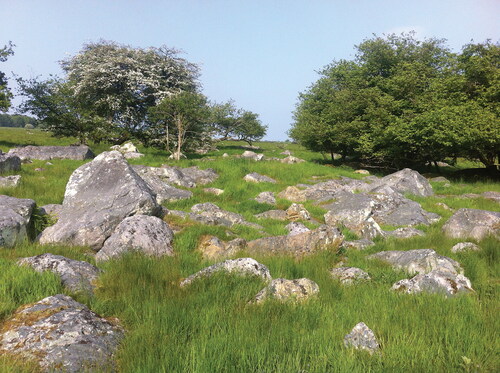
Sarsen stone is a silcrete dispersed across southern England from Devon to Norfolk. It appears amongst superficial deposits and scattered on the present-day land surface as cobbles and boulders known as sarsens (). Sarsens are composed of Tertiary quartz sands (occasionally with sparse flints) of the Lambeth Group aged c. 55 to 56 Ma. The sarsen blocks were formed underground more recently by geochemical processes, when silica carried in groundwater cemented areas of the sands together. The very hard, dense, homogenous bodies were left amongst surviving Tertiary deposits, became part of Clay-with-Flints and Plateaux Drift, or were deposited on denuded land surfaces, as a result of complex later Tertiary and Quaternary erosional processes. The boulders’ final positions are the result of periglacial movement and human activity. Usually comprising >90% silica, sarsen is also brittle with a reputation for sub-conchoidal fracture (Catt Citation2010; Entwistle et al. Citation2013; Geddes and Walkington Citation2005; Jones and Green Citation2013; Nash and Ullyott Citation2007; Summerfield and Goudie Citation1980; Ullyott et al. Citation2004). The distribution means that the ‘sarsen quarry’ is a dispersed and largely ephemeral feature, including the sites examined in this paper.
FIG. 1 Sarsens to the north of Delling Copse on Totterdown, Marlborough Downs, Wiltshire (photograph © author).
To an extent the vernacular term ‘sarsen’ became standard use in the 19th century (for example, Rupert Jones Citation1886). Other names include ‘breeding stone’ because of the boulders’ propensity to appear and multiply (perhaps lifted by ploughing or frost-heave), ‘druid stone’ for its use in prehistoric monuments, ‘grey-wether’ in analogy to browsing sheep and ‘saracen-stone’, as a foreign stone unrelated to the underlying geology (Adams Citation1870; Geddes Citation2000).
SARSEN STONE USES
Sarsen has been exploited since prehistory, most notably in Neolithic megalithic ritual monuments but also for tools such as querns and as building material in later prehistoric, Roman and early medieval structures (Bowen and Smith Citation1977). The stone serves both high and low status buildings, ranging from Windsor Castle’s extensive stone-built defences and residential quarters to cottages and agricultural buildings in both sarsen rubblestone and block walling (St John Hope Citation1913; Osborne White Citation1907). It may be used as the principal building or facing material (such as at Marlow Town Hall or Wycombe Abbey, Buckinghamshire); sometimes replacing or combined with timber-framing, paired with brick walling, or with brick or freestone dressings (for example College House, Lambourn, Berkshire); and both as unworked boulders and finely-dressed blocks in churches (such as at Clyffe Pypard and East Kennet, Wiltshire).
This flexibility is also evident in its role in surfacing, whether as cobble pitchings, road metal or shaped street furniture. For example, Marlborough’s older sarsen cobble streets were contrasted favourably with the unsatisfactory gravelled turnpike road by Benjamin Merriman, writing to Sir James Long in 1784 (WSHC 2943B/2/50). When Wiltshire County Council Roads and Bridges Committee moved to bring the formerly turnpiked road up to modern standards following the First World War, sarsen was one of numerous road metals ordered including tarred macadam, basalt, flint, limestone and gravel (WSHC F1/100/6/6). Later 19th century use of shaped sarsen setts, kerbstones and channelling is associated with the provision of new road- and footways in expanding urban areas (Allen Citation2015), such as growing towns like Swindon (King Citation1968, 87) and communities across Buckinghamshire where sarsen-paved crossings to poor-quality roads were appreciated by pedestrians until new tarred surfaces rendered them redundant (Bucks Herald, 7 October 1911). As late as 1912, Councillor Fisher recommended that Aylesbury Urban District Council lay sarsen paths in Walton Green (Bucks Herald, 17 February 1912), but in 1925 Amersham Parish Council sought to draw the County Surveyor’s attention to piles of sarsen setts that were inconveniencing pedestrians, presumably as pavements were re-surfaced with new materials (Bucks Herald, 3 October 1925).
SARSEN STONE STUDIES
Post-medieval sarsen stone exploitation is an under-researched hard-stone industry. Early 20th-century geological reports provide information about active family-run quarries in Buckinghamshire (Sherlock Citation1919, Citation1922; Sherlock and Noble Citation1912, Citation1922; Spicer Citation1905; Woodward and Herries Citation1905), on which Burtonwood’s (Citation1995) short review is based. The history of Wiltshire’s family-run sarsen quarries is based largely on family and oral histories (Crook and Free Citation2011; Free Citation1948, Citation1950; King Citation1968). Sarsen building stone is mentioned in southern England (Osborne White Citation1907, Citation1909, Citation1912, Citation1925) but only in north-west Surrey is quarrying briefly referred to (Dewey and Bromehead Citation1915, 546; Le Neve Foster Citation1894). Some regional church fabric and street furniture surveys include silcretes (Allen Citation2015; Cordiner and Brook Citation2017; Potter Citation1998). The only explicitly archaeological examination of post-medieval sarsen working concerns 18th-century megalith breaking during the dilapidation of prehistoric monuments at Avebury (Gillings et al. Citation2008).
It is not clear why this important regional trade has been neglected. In Buckinghamshire, extraction sites survive mainly in woodland and are less easily distinguished from other bulk mineral workings. The largest known extraction area, discussed here, is entirely redeveloped. Sarsen sources in the Berkshire-Hampshire-Surrey heathland are equally elusive, amongst extensive aggregates extraction and Ministry of Defence firing ranges. These difficulties may have dissuaded research. Wiltshire quarry sites are readily accessed but, as alluded to above, sarsen exploitation has been characterised negatively as the destroyer of prehistoric landscapes: apart from King’s (Citation1968) important paper, the focus of sarsen research has been to elucidate prehistoric relations with the stone (such as Bowen and Smith Citation1977).
To remedy this deficit, this paper presents results of the first analytical earthwork surveys to be made at Wiltshire extraction sites. In Buckinghamshire, remotely-sensed data combined with other archive material are used innovatively to explore the extractive landscape. The resulting nuanced insights into working practices in the quarries are used to disrupt conventional industrial archaeological narratives of post-medieval quarrying, instead focussing on the role of materials, and material properties of sarsen stone, in the ways that the quarries developed.
POST-MEDIEVAL QUARRY STUDIES
The UK has a long tradition of surface extraction and underground mining for stone reaching back to prehistory. Post-medieval quarrying exploited many different rock types for products ranging from small items, such as slate hone stones, to dimension stone for construction projects. Extractive practices also produced many essential minerals to be transformed by pyrotechnic processes, including clays, ores and limestones (Crossley Citation1990).
Despite their variety and importance, bulk mineral industries have received limited archaeological attention (Newman Citation2016). Stanier’s (Citation2000) Stone Quarry Landscapes, the Industrial Archaeology of Quarrying remains the only ‘reasonably comprehensive presentation of quarry-related archaeology’ (Thomas Citation2016, 67). Of particular relevance to this paper is scanty research into surface extraction sites (Thomas Citation2016, 74). Data issues contribute to these gaps. Progressive quarrying destroys earlier evidence; quarries become inaccessible through overgrowth, flooding or redevelopment; most quarries and quarrymen are invisible in documentary sources because of the limited regulation of all but the largest concerns (Samuel Citation1977; Stanier Citation2000).
The extractive industries are a topic of industrial archaeology, itself a strand of technology studies. Industrial archaeological studies often take a ‘common-sense’ position within the framework of the modern Standard View of technology, prioritising accounts of makers and inventors adapting to or controlling their environment (Conneller Citation2011; Dobres Citation2000; Orange Citation2008; Pfaffenberger Citation1992). In consequence, quarry surveys often produce technocentric descriptions of sites, equipment and products in the conventional industrial archaeological mode such as Gwyn’s (Citation1999) study of power systems in slate quarries or Trueman’s (Citation1992) analysis of the Langcliffe Limeworks. Emphasis is nevertheless placed on elucidating technical sequences: identifying geological sources, stone extraction methods, stone-working techniques, end products and their transportation off-site (Newman Citation2016; Stanier Citation2000). That approach is similar to the chaîne opératoire concept developed in prehistoric lithics analysis to understand such sequences, from stone procurement through tool manufacture, use and re-use, to eventual discard (Leroi-Gourhan Citation1993).
Technology research commonly focusses on innovation, framed in terms of linear evolutionary progress (Frieman Citation2023; Ingold [Citation2000] 2011, 362–6), but quarrying is typically depicted as traditional and resistant to change. A prevalent geological determinism constrains human agency, stating that quarrying techniques and products are determined by the bedding and jointing of quarried facies (for example Colfer Citation2010, 113; Stanier Citation2000, 10). Examined through an economic lens, the majority of quarries are characterised as under-invested, small-scale, seasonal and un-mechanised because land ownership was disassociated from control of the labour (Samuel Citation1977; Scott-Brown Citation2017), preserving a traditional industry. A key attribute of the sector is the deep time-depth of quarry tools and stone-working practices. Roman, medieval and later tools and techniques are largely similar, as are many quarries (Newman Citation2016, 59, 68, 72). In consequence, a nostalgic sense of timelessness pervades the literature, as direct connection is made across millennia via the small suite of hand-tools equally recognizable to a Roman as to a 20th-century quarryman (Stanier Citation2000, 21).
When innovation or change occur, they are commonly explained through external stimuli, such as improved transportation methods, labour-saving initiatives, urban development, or commercial growth (such as Greenwell and Elsden Citation1913; Newman Citation2016, 40; Scard Citation1989, 177–8; Stanier Citation2000, 17). Historical studies relying heavily, if not entirely, on documentary sources often characterise stone solely as a commercial commodity, underplaying both the technological context and varied properties of the materials themselves. For example, in her study of 19th-century stone-built housing in rural Wales, Alfrey (Citation2006) uses solely reports of the Royal Commission on Land in Wales and Monmouthshire, concluding that the forms of the region’s vernacular architecture were determined by geological constraints and variable access to economic leverage and construction skills. Born (Citation1988) draws largely on historical sources to describe the south Devon slate trade, concluding with the Victorian investment value of the business. Linsley (Citation1990, 178) even goes so far as to state that identifying the location of Brockholm millstone quarry in Northumberland ‘is less important than the information on its products and customers that can be gleaned from a surviving account book’.
Conventionally nostalgic, economic or technocentric accounts may be challenged, however, by multi-scalar analyses of the technical actions of quarrying – from individual tool traces, to the whole quarry and its products – which, interwoven with archive sources, can reveal the complexity of practices. Detailed attention to the morphology and sequences of tool-marks in rock-cut architecture (Lamesa Citation2017) and architectural sculpture (Rockwell Citation1993), for example, reveal the interplay between geology, tradition and artisanal practice. Studies such as Morleghem’s (Citation2016) examination of sarcophagus production and Willies, Redvers-Higgins, and Wain (Citation2011) exploration of Combe Down stone mines demonstrate the importance of taking a more critical view of stone procurement and use.
Furthermore, more nuanced social archaeological and ethnohistorical approaches draw attention to impactful human agency and personal relations in working mineral resources (for example Knapp Citation1998; Mate Citation2013). These include the application of oral history and social anthropological methods exemplified by Samuel (Citation1975, Citation1977), who depicts quarrymen at the intersection of labourer and artisan, exercising strength, skill and judgment in their work. Prehistorians such as Brück (Citation2006), Conneller (Citation2011) and Dobres (Citation2000) have applied the lens of Science and Technology Studies to stone-working technology, understanding it not as a functional absolute but as a problem-solving process mediated by people’s understanding of materials and how to use them. Different stone types offer different properties and affordances, and their procurement is hedged around by particular physical and historically-contingent contexts. Although the suite of quarrymen’s tools may be relatively small, the materials to which they are applied are diverse, resulting in stone-specific techniques. The close examination of materials and technologies to ‘reveal the complexity of person-material-technological relationships’ encouraged by Conneller (Citation2011, 25) is just as relevant to post-medieval stone use as it is to prehistoric.
AIMS AND METHODOLOGY
This work aims to describe and interpret the archaeology of the English post-medieval sarsen industry. The great majority of workings were shallow surface pits falling out-with regulatory powers, rarely appearing in Home Office Mines Inspectorate reports. Consequently, a multi-scalar approach is taken in three case study areas, including a close examination of material and technological evidence interpolated with an eclectic variety of archive sources. This paper focusses on the field archaeology results and evidence gathered from remotely-sensed data.
As a component of superficial deposits, sarsen is not mapped by the British Geological Survey (BGS): thus, potential geological sources cannot easily be targeted. Proxies at varying scales locate and map the presence of sarsen boulders, providing the geological context for the industry. The case studies were selected on the basis of this new mapping combined with existing historical accounts: an area in south Buckinghamshire and two locations in north Wiltshire.
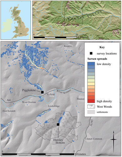
The survival of archaeological evidence is substantially different between the study areas, requiring that different, complimentary, methodologies be employed. Surface sarsen spreads exploited in Wiltshire are in areas now largely protected by environmental legislation. Quarry archaeology is thus well-preserved, but distributed across a huge area. An intensive approach was taken to record extractive features at two locations where different quarrying techniques were used: Piggledene, worked traditionally before 1907; and Hursley Bottom, a mechanised road-stone quarry operational in 1920 (King Citation1968) (). Level 3 analytical earthwork survey was carried out to industry standards (Bedford et al. Citation2016; Jamieson et al. Citation2017) in a representative sample of each landscape. The surveys included detailed metrical analysis of extant stone-working traces on individual boulders, informed by Stanier’s (Citation2000, 36–8) schedule for investigating quarries but drawing explicitly on the methodological framework of the chaîne opératoire to document, where possible, specific quarrying processes and their sequential technical actions with a focus on stone selection and reduction. The measured surveys were augmented by walk-over surveys of the surrounding quarried areas.
FIG. 2 Map showing the location of the Piggledene and Hursley Bottom surveys in relation to topography, with sarsen stone spreads as recorded by Ordnance Survey up to the Second World War (includes data derived from EDINA Digimap, Ordnance Survey data © Crown copyright and database rights 2021, 90 m STRM courtesy of CGIAR http://srtm.csi.cgiar.org and 2 m photogrammetry © Bluesky International Ltd/Getmapping Plc).
On Buckinghamshire’s Chiltern Hills, sarsen stones are found both singly and in tightly-defined clusters of hundreds of tons of stone buried in Plateau Drift. Extractive features were digitised from historical Ordnance Survey maps in a 210 km2 survey area (). Albeit arbitrary, given sarsen dispersal, the boundary was defined by the intensity of existing sarsen stone records (Davies and Baines Citation1953; Prestwich Citation1854; Sheahan Citation1872; Sherlock Citation1922; Sherlock and Noble Citation1912, Citation1922; Spicer Citation1905; Woodward Citation1891). The resulting dataset provides the overall context of extractive industry within which sarsen was exploited, in more detail than Mines Inspectorate reports that are limited to regulated quarries: Ordnance surveyors mapped all features that made a definite impact on the landscape (Oliver Citation1993, 98).
FIG. 3 Map showing the location of the Buckinghamshire survey area and Walter’s Ash study area in relation to topography, with sarsen stones recorded by Davies and Baines (Citation1953) (includes data derived from EDINA Digimap, Ordnance Survey data © Crown copyright and database rights 2021, 90 m STRM courtesy of CGIAR http://srtm.csi.cgiar.org and 2 m photogrammetry © Bluesky International Ltd/Getmapping Plc).
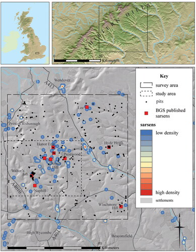
Analytical earthwork survey could not, however, easily be applied there. Dispersed pits survive in woodland but are largely ploughed out elsewhere. An intense sarsen aggregation at Walter’s Ash (Bovill Citation1903) was worked from thick superficial deposits that fill numerous dolines (Lim, Clark, and Linares-Matás Citation2020, 6). Unfortunately, the northern part of that quarry was returned to arable whilst the southern part was developed by the Ministry of Defence after the Second World War (Freeman Citation2001, 16). The pits were, however, left open prior to re-development. It is reasonable to assume that 1940s aerial photographs, and in particular coverage of Walter’s Ash flown in 1942, captured the quarry as close as possible to its final pre-development form. An extensive approach was taken, therefore, to record the extractive landscape of a 48 km2 study area centred on Walter’s Ash (). Digitising and interpreting features from a combination of aerial photographs and Lidar data, to National Mapping Programme standards (Evans Citation2019; Truscoe Citation2017, 9–15), provides an innovative solution to the problem of covering the area in detail.
Both the methodology applied and the interpretation of the mapped landscapes is influenced by Ingold’s (Citation1993) ‘dwelling perspective’, from which landscape is seen as a record of life lived over time, the landscape forms incorporating and arising from processes including the geological, technological and human (discussed in more detail below). This is important to the attempt to move beyond the narrowly technocentric tendencies of many quarry studies, which detailed mapping and survey could otherwise encourage. However, archive material from numerous sources contributed to the selection of the study areas and is essential to understanding each. That underlines the contention of both Johnson (Citation2007) and Hicks (Citation2016) that archaeological knowledge is constituted by the sources upon which we choose to draw, by the investigative work done in a landscape, and by the archive resulting from the documentation practices selected for that fieldwork. An outcome of taking different approaches to the study areas is that each locality is addressed at a different interpretative scale.
BUCKINGHAMSHIRE
INTRODUCTION
There are no major resources of building stone in Buckinghamshire
(Benham et al. Citation2003, 9).
Buckinghamshire is not renowned for hard-stone quarrying. From 1895 to 1920, on average 22 quarries were worked each year in the county, employing on average 112 workers between them (). It is likely that all the quarried sandstone was sarsen, known by locality names including Denner Hill Stone, Wycombe Stone and Hampden Stone (Burtonwood Citation1995; Woodward Citation1905). Those names indicate an area around Hughenden parish where superficial geology including substantial deposits of Plateau Drift and Clay-with-Flints mantle the largely wooded Chiltern Hills (Coppack Citation1962; Davies and Baines Citation1953; Ellis and Jamison Citation1925, 57).
TABLE 1 Home Office Mines Inspectorate Reports data for working quarries from 1895, the first reporting year under the Quarries Act (Citation1894), to 1920 when the Reports series ended and became a Board of Trade (Mines Department) internal report.
Southern Buckinghamshire remained a largely rural area, less affected by later 19th-century industrialisation and the rural depopulation of the agricultural depression, because its farmers served nearby London markets (Reed Citation1979, 227–8). Hughenden’s later 19th-century population was quite stable, on average 1765 people from 1881 to 1901, before rising to 2523 in 1921 (GB Historical GIS Project 2009–Citation2017a). The parish’s heathland enclosure was completed late-on, in the mid 19th century, impacted by the small proprietorship that characterised Chiltern Hills’ landholding (Reed Citation1979, 199–205); a factor important to the management of the sarsen trade, as discussed below.
Sarsen pits on Denner Hill were worked until just before the First World War (Sherlock Citation1922, 55; Woodward and Herries Citation1905) and must have been exploited since much earlier for the locality name to have developed. Expertly split, shaped and dressed sarsen was being used in local construction by the beginning of the 19th century, if not before. Examples include Wyatt’s remodelling of Wycombe Abbey, c. 1803–04 (Pevsner and Williamson Citation1994, 391); the rear wing extension of Denner Hill Farmhouse, c. 1800, and its barns dated 1803–04 (NHLE 1160234 Citation2017; NHLE 1332051 Citation2017); Marlow Town Hall, 1806 (Pevsner and Williamson Citation1994, 458). In earlier instances, local stone-cutters appear in legal documents including Thomas Watts of Chipping (High) Wycombe, leasing property in 1736 and 1740 (BA, CH 1/T/24, D-CN/9/5/1/21). The industry was largely at a close by the Second World War, the ‘last stone mason’ working in 1950 (SWOP, RHW:50634).
Identifying sarsen pits is problematic for a number of reasons. There is no bedrock quarry because boulders are scattered in the superficial deposits. As well as chalk and marl the locality provided clays, sand and gravel, resulting in numerous extractive features. Brickearth was a useful by-product of the sarsen trade (Whitaker Citation1864), complicating the identification of stone pits. A broad assessment of late 19th- and early 20th-century bulk mineral extraction in the survey area demonstrates this variability.
EXTRACTIVE INDUSTRIES
Within the survey area 217 pits and quarries (both active and ‘old’/‘disused’) are recorded on first edition Ordnance Survey maps (1867–81) – on average one per 1 km2 – indicating the prevalence and local significance of bulk mineral extraction () (). The majority are identified as chalk pits (105, 49%), indicating chalk’s importance for various purposes, common to other counties (Allen Citation2017). Twenty-six clay pits (12%) include those at brickworks such as at Hyde Heath, where sarsens were also present (see Sherlock [Citation1922, 41]). There are fewer gravel pits (sixteen, 7%) and sand pits (three, 1%), although the area opened up for gravel extraction was bigger than that for clay (1.59 ha compared with 0.94 ha). Twenty-two sites (10%) are called quarries: fourteen are in chalk whilst eight cut superficial deposits. At Stony Green and to the south-west of Naphill Farm, two quarries are at sarsen-producing areas. In fact, six quarries are within 1 km of a sarsen location named in geological literature. Although fewer pits are recorded by the Epoch 2 re-survey (1897–99), the numbers of clay pits and unidentified extractive pits increase on Epoch 3 maps (1918–24) when, for the first time, pits appear to the east of Walter’s Ash Main Road.
TABLE 2 The number of extractive pits mapped by the Ordnance Survey on County Series 1:2500 maps in the survey area SU 810 950 (south-west corner) to SP 930 060 (north-east corner).
Although the Ordnance Survey had not identified any marl pits in the survey area, marling was significant on the Chiltern Hills after the First World War, described in detail by Sherlock (Citation1922, 55). Thus, the landscape was further marked by pits supplying alkaline soil improvers applied over acidic superficial deposits. They result in well-defined sub-circular depressions usually located in the centre of fields, with a characteristically regular distribution. In the Walter’s Ash study area, 435 marl pits exhibiting these characteristics were mapped from remotely-sensed data ().
TABLE 3 Pits mapped in the Walter’s Ash study area by extracted material.
Dating these marl pits is difficult with no phase relationships to other features. Priest (Citation1810, 268) reports that soil improvement was prevalent across Buckinghamshire by the end of the 18th century, associated with the management of enclosed land. Some 145 (33%) marl pits in the study area are associated with 18th- and 19th-century enclosures as identified through Historic Landscape Characterisation (Green and Kidd Citation2006) (). In all likelihood some, perhaps many, were being opened throughout the period of post-medieval Improvement and into the early 20th century.
TABLE 4 Distribution of marl pits mapped in the Walter’s Ash study area by Historic Landscape Characterisation land-use.
WALTER’S ASH QUARRY
At Walter’s Ash, a cluster of pits in Plateau Drift provided sarsen boulders weighing on average 40 tons each (Catt Citation2010, 87; Sherlock and Noble Citation1912, 201; 1922, 35; Spicer Citation1905). It is not yet clear when this area was first quarried. The fields are adjacent to Walter’s Ash Farm, where John Hall worked sarsen from the 1840s (Burtonwood Citation1995). The works were reopened following the First World War hiatus (Sherlock Citation1919, 191; 1922, 55), comprising Bristow’s Stone and Brickyard to the north and Brown’s (Wells) Brickfield to the south (BA, D-X/935). Bristow family members were stone-cutters from at least the mid 19th century perhaps also providing this service for James Brown’s neighbouring brickfield. A small number of the same families living in the neighbourhood provided the workforce throughout the time the pits were operational (Whitaker in preparation).
Spicer (Citation1905) (who also noted clay as a by-product of sarsen extraction) describes one of the Bristow’s Yard pits, around 36 m diameter and 12 m deep containing brickearth and sarsens (). When Clay-with-Flints were encountered, known by the quarrymen as ‘rock’, the limit of ‘profitable operations’ for each stone pit had been reached (Spicer Citation1905, 40). Bovill (Citation1903, 368) reports that the stone-cutters paid landowners a royalty for quarrying rights, based on the quantity of extracted stone, or bought land outright.
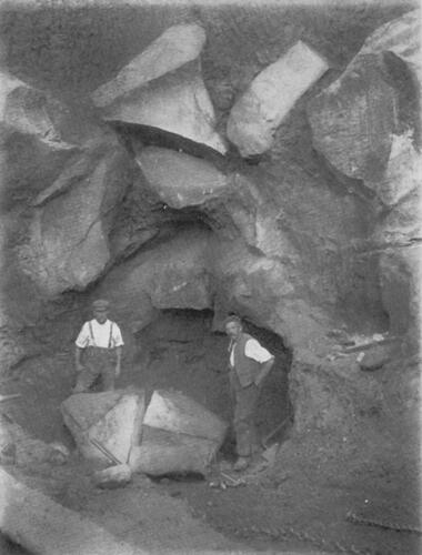
FIG. 4 Two sarsen-cutters standing either side of a partially cut boulder in the bottom of a pit at Bristow’s Stone and Brickyard, early 20th century. This is not the pit observed by Spicer (Citation1905), but is on the same site which he visited (source: The Geologists’ Association).
Processes employed in the quarry can be reconstructed from a combination of geological accounts and archive photographs. Quarrymen prospected by probing the surface with metal rods called ‘snipers’. Locating and hand-excavating individual boulders produced lobed pits on plan, with steep sides. Those irregular shapes and near-vertical sides were maintained as the pits were extended downwards, following the deposit. Simple scaffolding, sheer-legs with block and tackle and windlasses were used to access the pits and raise material. Primary reduction occurred in situ using flat wedges to split large boulders into pieces. Above ground, secondary reduction included further subdivision into blocks (). Tertiary reduction produced setts, kerbstones and building blocks, some of which were dressed for a more precise shape and finer finish (Green Citation2016, 356–7; Whitaker Citation2019, 105–7) (). Such simple infrastructure contributes to the ephemeral nature of the dispersed sarsen quarry and difficulty of identifying stone pits in the landscape. The intensity of the Walter’s Ash site and coverage by aerial photography, however, uniquely enables the further analysis of the layout of the extractive area and pit forms.
FIG. 5 The Walter’s Ash sarsen quarry: (a) scaffolding and a windlass suspended over a pit, surrounded by split sarsen blocks and waste, 1915 (P250215); (b) a pile of partially-prepared sarsen blocks intended for Windsor Castle, 1919 (P250214) (courtesy of the British Geological Survey http://geoscenic.bgs.ac.uk).
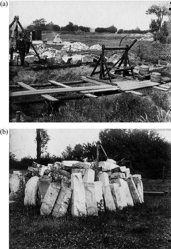
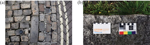
FIG. 6 Buckinghamshire sarsen products: (a) setts and kerbstones in Market Place, Aylesbury; (b) a corner-stone at Holy Trinity Church, Prestwood retaining two wedge-pit scars (photographs © author).
Towards the end of its life, Brown’s Brickfield included a maximum of 60 pits ranging from 15.1 m2 to 2242.2 m2, 34 (57%) of which were under 150 m2. Also close to closure, Bristow’s Yard included up to 53 pits between 18.8 m2 and 3889.0 m2 (). Although including by far the single largest extractive feature before its back-filling was completed by August 1961, the majority of Bristow’s Yard pits were also under 150 m2 (37, 69%). By 1942 some of the pits included scrub, indicating that they had not been worked for a few seasons, but a few were newly-opened after the Second World War on Brown’s Brickfield for the final years of brick production.
FIG. 7 Transcription from aerial photographs of archaeological features of all dates in the environs of Bristow’s Stone and Brickyard and Brown’s (Wells) Brickfield, Walter’s Ash, Buckinghamshire (includes data derived from EDINA Digimap, Ordnance Survey data © Crown copyright and database rights 2021).
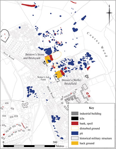
Despite interior overgrowth, in the 1940s the pits still had crisply-defined edges and steep sides with no obvious access ramps visible. There is no evidence in the aerial photographic coverage for mechanised excavation. The smallest pits (defined as <150 m2) were on the whole single or two-lobed on plan, only those at the larger end of that size class becoming more complex. The largest pits, however, were highly irregular in plan form, multi-lobed and with irregular bases, giving the impression that sarsens and brickearth were ‘chased’ until individual pits were worked out. The land between the Brown’s Brickfield buildings and Courns Wood was very thoroughly quarried, whereas the pits on Bristow’s Yard were more dispersed. Significantly, although ten pits were extended to more than 500 m2, ground was not unnecessarily dug away in extensive open-area excavations. In Bristow’s Yard in particular substantial open ground remained between some of the pits ().
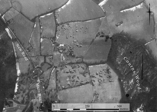
FIG. 8 Bristow’s Stone and Brickyard and Brown’s (Wells) Brickfield, Walter’s Ash, 14 February 1942 (RAF/HLA/403 V 25) (with permission from Historic England Archive/RAF Photography).
The limited number of spoil heaps is noticeable. Aside from two smaller and one large clay pile beside Bristow’s Yard hack ground (brick-drying area), there were seventeen small, low spoil heaps closely associated with pits in the quarried area. Brown’s Brickfield also kept clay piles beside its hack ground, but there is only one identifiable spoil heap associated with three pits in the quarried area. An additional spoil heap was later built up to the south-east side of the quarried ground, in place by May 1954 when only bricks were being made. That suggests the economical nature of the industry during the most active extraction periods, with perhaps limited overburden, abundant brickearth and sarsens removed by careful hand-digging, and waste sarsen returned to pit bases or further broken up for road-stone (as Bristow’s advertised, see Kelly’s Directory of Buckinghamshire [1911, 41]).
The aerial photographic transcription also reveals the full extent of Howard’s Brickworks on Honor End Lane (BHER 0505600000 Citation2021), providing a valuable comparison (). Opened by Samuel Howard in 1895 some 4 km to the north-east of Walter’s Ash and worked until the 1960s, the site was developed in superficial deposits on the chalk plateau above Hampden Bottom. Although recorded only as a brickworks it is geologically and topographically similar to Walter’s Ash and Denner Hill, and sarsens were noted by Sherlock (Citation1922, 41) at the brickworks and Nanfans Farm just to the south.
FIG. 9 Transcription from aerial photographs of archaeological features of all dates in the environs of Howard’s Brickworks, Honor End Lane, Buckinghamshire (includes data derived from EDINA Digimap, Ordnance Survey data © Crown copyright and database rights 2021).
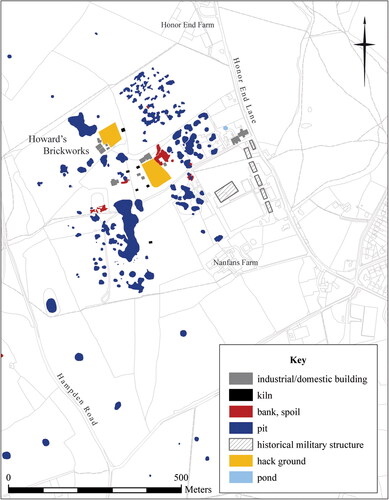
At its fullest extent, the extractive area included 115 pits ranging from 5.5 m2 to 7105.1 m2, of which 62 (54%) were under 150 m2. The largest feature comprised a highly irregular pit already overgrown by the 1940s: smaller pits, including both simple single-lobed and more complex features, were scattered predominantly to its south and west up to 50 m apart separated by areas of unexcavated ground. The open pits commonly exhibit the same irregular plan forms and bases as at Walter’s Ash. Although the scrub growing in some pits shows that most were at the end of their working lives, their sharp edges and steep sides are still well-defined in photographs of 1946–47. The exception is an area of probable pits on the north of the site showing as cropmarks on photographs dating to 1948. Closely clustered and highly irregular in plan form, they had been backfilled and reverted to agriculture. Only one pit in that group showed as a slight earthwork depression in photography of the previous year, suggesting that the ground had been under cultivation for some time. That contrasts to the final workings on the site visible in aerial photographs dating to 1969 in which a dragline is in operation in a large open pit to the west of the cropmark site.
The proliferation of pits scattered across the site separated by large areas of unexcavated ground, and the range of their plan forms with steep sides, well-defined edges and no ramps, suggest that similar extractive practices were in use on Howard’s Brickworks before the Second World War as the Walter’s Ash yards. Given the similar superficial geology and topography, it is likely that sarsens were also encountered. Honor End Lane did not develop a reputation for the stone, but it is conceivable that local sarsen-cutters living in Honor End and nearby Prestwood (Whitaker in preparation) were involved in removing sarsens from those fields.
WILTSHIRE
INTRODUCTION
Similarly rural to south Buckinghamshire, Wiltshire parishes where sarsen is prevalent have nevertheless a very different history. Landholding is dominated by large medieval ecclesiastical estates running huge flocks of sheep on open chalk Downland, transformed by 18th-century Improvement and early 19th-century Enclosure into large, secular, farms (Fowler and Blackwell Citation1998, 138–43). In West Overton parish, the location of the two study areas described in this paper, between 1881 and 1901 the population was on average 643 people, approximately one-third smaller than its early 19th century population; numbers continued falling, to only 515 people in 1921 (GB Historical GIS Project 2009–Citation2017b).
Hard-stone quarrying has nevertheless been more significant economically to Wiltshire than Buckinghamshire. Between 1895 and 1920, on average 42 quarries were worked each year in the county, employing on average 225 workers between them (). Around 1900, sarsen-cutters produced annually some 300 tons of prepared stone (King Citation1968, 88); but the county’s total recorded sandstone volume is unlikely to include sarsen, because the surface quarries were unregulated. Sarsen is today most prevalent on the Downs to the north and south of the Kennet Valley ().
Allegedly, Wiltshire’s sarsen was known to be impervious to working with iron tools, knowledge originating with Rastell (Citation1530) and repeated by later commentators: the conventional view is that, prior to c. 1850, sarsens were shattered by thermal shock as described by antiquaries Aubrey (Britton Citation1847, 44) and Stukeley (Citation1743, 15) to produce rubblestone and roughly squared building blocks (Geddes Citation2000, 80; King Citation1968, 85–6). From 1847, members of Buckinghamshire stone-cutting families moved to the Kennet Valley to take advantage of easily accessed surface sarsen spreads. They revolutionised the industry by introducing specialist metal tools and superior techniques to produce evenly split and finely dressed blocks, teaching the skills to a small number of local men (Crook and Free Citation2011; Free Citation1948, Citation1950; King Citation1968).
According to Free (Citation1948) (member of a Buckinghamshire stone-cutting dynasty) and King (Citation1968), the technique involved digging a gully around a boulder on which lightly-chiselled guide-lines marked the desired primary splits (). The guides would normally be aligned to natural cracks. Along the lines, wedge-pits from 2.5 cm to 3.75 cm deep were cut out every 30 cm using a pecker and finished with points (). Flat wedges inserted between thin iron strips were placed into each wedge-pit and sledged until the stone split. Secondary reduction involved further subdivision by perpendicular splits, followed by tertiary reduction using a slicing chisel held in a twisted hazel wand, struck with a tracing hammer, to cut setts, kerbs and building blocks (). If necessary, dressing was completed using a pecking hammer.
FIG. 10 Wiltshire sarsen quarry evidence, tools and products: (a) stone [6] in Piggledene marked by a chiselled guide-line (below scale bar) and cut with two wedge-pits; (b) a wedge-pit scar in stone [12], Piggledene; (c) five pecker heads for working sarsen (DZSWS/GB236/2, Wiltshire Museum, Devizes); (d) a slicing chisel for working sarsen (DZSWS/GB236/1, Wiltshire Museum, Devizes); (e) a sarsen kerbstone retaining a wedge-pit scar, Purton, Wiltshire; (f) sarsen kerbstones, Wroughton, Wiltshire (photographs © author).
![FIG. 10 Wiltshire sarsen quarry evidence, tools and products: (a) stone [6] in Piggledene marked by a chiselled guide-line (below scale bar) and cut with two wedge-pits; (b) a wedge-pit scar in stone [12], Piggledene; (c) five pecker heads for working sarsen (DZSWS/GB236/2, Wiltshire Museum, Devizes); (d) a slicing chisel for working sarsen (DZSWS/GB236/1, Wiltshire Museum, Devizes); (e) a sarsen kerbstone retaining a wedge-pit scar, Purton, Wiltshire; (f) sarsen kerbstones, Wroughton, Wiltshire (photographs © author).](/cms/asset/55e48f0d-59a5-43dd-9a18-fbccbae6a1b8/ypma_a_2173713_f0010_c.jpg)
Other methods were used, however, to quarry sarsens. King (Citation1968, 86–7) also describes, in less detail, a road-stone operation using explosives and a mechanical crusher to quarry and break sarsens in Kennet Valley’s West Woods. The excellent preservation of that area, and the survival of sarsen extraction pits amongst the Downland sarsen spreads, provides the circumstances to examine these workings and quarrying practices.
PIGGLEDENE
Piggledene in West Overton is a dry chalk valley, a northern re-entrant of the Kennet Valley cutting the Downland dip slope. The valley bottom includes Head deposits and an extensive surface spread of sarsens scattered across the pasture in its southern end. A photograph of 1908 shows stone-cutters at work in Piggledene immediately to the west of Pickledean Barn, and the Cartwright family quarried sarsen in the valley in 1912–15 (King Citation1968), but it is not known when sarsen-cutting began there. The National Trust owns some 3.8 ha, purchased by public subscription in 1907–08 following a campaign to protect areas from being completely worked out (Anon Citation1908). In consequence, areas including surviving boulders, partially-worked stones and empty stone pits are well-preserved. A 0.24 ha measured survey transect was located across the valley bottom to record in detail the range of surviving quarry features (). The transect was bounded on the steep west slope of the valley by a fence-line on a substantial lynchet, and to the east by a fence-line butted up against a bank and hedge at the base of the opposite slope. The valley bottom slopes gradually from west to east. The measured survey was complimented by a larger walk-over survey ().
FIG. 11 Measured survey showing earthworks, stone pits and hollows, partially split sarsens and surviving whole sarsen boulders in Piggledene, Wiltshire.
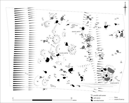
FIG. 12 Map showing walk-over survey extents in the Wiltshire sarsen quarries: (a) Piggledene; (b) Hursley Bottom. Walk-over survey areas are hatched, analytical earthworks survey areas are cross-hatched (includes data derived from EDINA Digimap Ordnance Survey data © Crown copyright and database rights 2021 and 50 cm Digital Surface Model LiDAR data © Environment Agency copyright and database right 2015 [Multi-lit Hillshade visualisation made using the Relief Visualization Toolbox]).
![FIG. 12 Map showing walk-over survey extents in the Wiltshire sarsen quarries: (a) Piggledene; (b) Hursley Bottom. Walk-over survey areas are hatched, analytical earthworks survey areas are cross-hatched (includes data derived from EDINA Digimap Ordnance Survey data © Crown copyright and database rights 2021 and 50 cm Digital Surface Model LiDAR data © Environment Agency copyright and database right 2015 [Multi-lit Hillshade visualisation made using the Relief Visualization Toolbox]).](/cms/asset/1078824b-ba79-46ba-a223-220ef0ad6ef2/ypma_a_2173713_f0012_c.jpg)
The transect includes numerous earthwork quarry features and worked and unworked sarsens. Fourteen well-defined shallow, oval, stone extraction pits range from 2 m to 5.3 m in length and 0.1 m to 0.3 m in depth. Most of the pits are in the western part of the transect. Pits [A], [B] and [N] have clearly defined sides, but the remainder tend to have a steeper western side petering out to the east. Eight pits contain or have adjacent sarsen cutting debris. The smallest pits [E] and [H] are empty, but are within the range of boulders in the valley bottom and may be extraction pits for smaller sarsens. The irregular form of pits [K] and [L] may have resulted from different disturbance, such as flint digging or tree throws, but again they are within the range of the smaller boulders. Some split sarsens are enclosed by shallow gullies, such as stones [122] and [144]. Other split boulders have no gully, including stones [20], [34], [106], [107], [143] and stone groups [83]/[84] and [89]/[100].
Gently sloping linear features extending north-south along the valley bottom are probably natural scarps of superficial deposit resulting from sediment movement in periglacial conditions (Clark, Lewin, and Small Citation1967, 23; Murton and Ballantyne Citation2017, 542). To the north-east side of pit [G], however, a slight bank is possibly an area of spoil, as is the more substantial bank to the north of stone [74] which may comprise mounded and overgrown debris near split and unsplit boulders [75] to [80]. That broader, flatter platform was perhaps prepared for the location of tertiary reduction and finishing, completed in the open air under the shelter of propped hurdles (King Citation1968, ), a practice used in Buckinghamshire and other stone quarries (Greenwell and Elsden Citation1913, ).
The transect includes 156 boulders and stone pieces. All are pale grey sarsen containing a very few examples of visible flint clasts and the occasional natural crack. Forty-eight have unequivocal working evidence including split faces and wedge-pits. Thirty-one are unworked boulders. The remaining 77 are too well buried or overgrown with moss and lichen for conclusive examination, although some, like the small angular blocks in pit [B], are probably splitting debris. A less cautious estimation including probable debris suggests a total of 80 worked pieces. In terms of a simple count, more split sarsen pieces remain in the eastern part of the survey transect. Unworked sarsens and those which cannot with certainty be identified as worked are fairly evenly distributed across the transect.
Evidence for the Buckinghamshire technique of splitting with flat wedges is abundant. Sixty-one trapezoidal wedge-pits for wedges are present, commonly visible as scars in split stone surfaces (); only seven wedge-pits are whole and unused. The wedge-pits are usually slightly asymmetrical, one end a little shallower and straighter than the opposite steeper, sometimes slightly convex, end. The opening in the stone surface is always longer and wider than the base. Whilst the origins of splitting stone with flat wedges in variably-shaped wedge-pits are Roman, the method was applied to many different stone types across England from the medieval period (Stanier Citation2000, 21–3). There is also one cylindrical plug-hole for plug-and-feather splitting in stone [69] (). Plugs are cylindrical, tapered wedges flanked by two semi-cylindrical feathers, fitting into bored or chiselled holes. They were introduced from the early 1800s (Greenwell and Elsden Citation1913, 293–4; Stanier Citation2000, 43).
FIG. 13 A plug-and-feather scar in stone [69], Piggledene (photograph © author).
![FIG. 13 A plug-and-feather scar in stone [69], Piggledene (photograph © author).](/cms/asset/3b3c5249-e533-4815-9f32-9b5841b850eb/ypma_a_2173713_f0013_c.jpg)
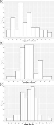
Although regular in form, wedge-pit dimensions vary (). The mean length of wedge-pit openings is 90.9 mm but they range from 71 mm to 120 mm. The majority (34, 57%) are between 80 mm and 100 mm long but eight cluster around 75 mm long. Measurable wedge-pit bases are on average 47.2 mm long with a similarly broad range; the majority (28, 52%) are between 40 mm and 50 mm long, with a cluster of seven around 60 mm long. In the majority of instances, it is not possible to measure wedge-pit width, because only one half survives as a scar on a stone face. Depth, measured on the scar centre line, is on average 43.9 mm but, as the range of 14 mm to 74 mm indicates, it is difficult to identify the top of each wedge-pit consistently in uneven stone surfaces. Whilst it is possible that clusters of wedge-pits around certain sizes could represent the work of individuals, the suggestion should be treated with caution. Wedge-pits and wedge-pit scars in each of the ranges are evenly distributed across individual boulders and across the survey transect, rather than clustered discretely on specific boulders. Furthermore, variations in the order of ±10 mm could be ascribed to simple factors including the way stone splintered and spalled during cutting, or variability in recording dimensions in the field.
FIG. 14 Range and distribution of wedge-pit sizes in Piggledene: (a) length of wedge-pit openings; (b) length of wedge-pit bases; (c) wedge-pit depth.
There are three variants in the treatment of boulder surfaces around the wedge-pits. Stone [6] has the only example of a guide-line lightly chiselled along the course of an intended split, with two wedge-pits cut into the surface on its route (). The stone surface around two wedge-pits in stone [34] is pecked away forming two rectangular depressions (). In numerous instances, small flakes of stone spalled around wedge-pit openings during the shaping process; but on stone [84], the loss of a large flake ruined the first wedge-pit and a second was made approximately 15 cm further over ().
FIG. 15 Stone surfaces in Piggledene: (a) two sub-rectangular depressions removed from the surface of stone [34], each above a wedge-pit in the stone face; (b) a large flake scar in the surface of stone [84] originating from a wedge-pit (parallel to the scale card) (photographs © author).
![FIG. 15 Stone surfaces in Piggledene: (a) two sub-rectangular depressions removed from the surface of stone [34], each above a wedge-pit in the stone face; (b) a large flake scar in the surface of stone [84] originating from a wedge-pit (parallel to the scale card) (photographs © author).](/cms/asset/0058d51c-97c1-4c91-b816-92e52aaab621/ypma_a_2173713_f0015_c.jpg)
Wedge-pit positioning is also variable (). Of eighteen sarsens with one split surface, wedge-pits are pecked into the upper surface of thirteen. Three boulders were split from the side; they were broader at the base than the top, broken with wedges inserted close to the ground towards the thickest part of each boulder. Stones [28] and [34] have wedge-pits in the top and one side. Wedge-pit arrangement is more complicated in sarsens with multiple perpendicularly spilt faces, and can indicate splitting sequences. In stone [12], for example, at least one wedge was used in the top of the boulder to remove the northern part. A second, perpendicular, split was made with one wedge in the top of the stone and another in the middle of the freshly split face, positioned between the thinnest and thickest parts of the remaining material. Only five boulders have faces split by more than two wedges: stones [28], [91], [97] (three wedges); stone [34] (four wedges); and stone [147] (six wedges). The distance between these wedge-pits is highly variable ().
FIG. 16 Split sarsens in Piggledene with wedge-pit positions marked by scale cards: (a) stone [28] with three wedge-pits visible in the split face; (b) stone [12] with half a wedge-pit in the north face and two wedge-pits in the west face; (c) stone [34] with four wedge-pits in the split face (photographs © author).
![FIG. 16 Split sarsens in Piggledene with wedge-pit positions marked by scale cards: (a) stone [28] with three wedge-pits visible in the split face; (b) stone [12] with half a wedge-pit in the north face and two wedge-pits in the west face; (c) stone [34] with four wedge-pits in the split face (photographs © author).](/cms/asset/b73b69d6-57bf-46d0-8cfb-151ebcf293ab/ypma_a_2173713_f0016_c.jpg)
TABLE 5 Distances between wedge-pits placed in the same plane in sarsens in the Piggledene survey transect, in boulders where more than three wedges were used.
Splitting sequences of two of the most complex stone groups serve to illustrate the importance of precise perpendicular splits to the stone-cutters’ approach to reducing boulders into regular units. In a large tabular sarsen broken into stone group [89]/[100], primary north-south splits produced blocks which were then reduced by secondary east-west splits. Smaller pieces were then made by further north-south splits. Each division is perpendicular to the previous one. In stone group [131]/[136], derived from a large, more irregular, pillowy boulder, the two rounded ends were split away first, then broken in half by perpendicular splits. The group was then abandoned prior to any further reduction, probably because the split dividing stone [136] from [134] failed: instead of travelling straight from the surface to the base of the stone, it ran out to the side in a deep curve, probably diverted by interrupting flints embedded in the boulder’s sand matrix which are now visible in the split faces.
Stone [47] offers a further example of sarsen stone’s occasional intransigence. Its eastern portion was removed first and the remaining part divided perpendicularly east-west, but it did not conform to expectations and that second split curved out to the south, removing the top surface rather than perfectly halving the block. The southern-most end was then removed from the damaged boulder and the remainder was abandoned.
Similar quarry features are distributed throughout the rest of Piggledene, observed during the contextual walk-over survey. The quarrying continues to the southern-most extent of the valley where it is cut off from the River Kennet by the embanked A4 road. An earthen ramp leads out of the valley’s southern end up to the road, banked up against the northern side of the road embankment. In addition to the single plug-and-feather example in the survey transect, there are four more instances of that splitting method elsewhere in the valley bottom: two boulders to the south of the transect and two to its north, containing eight measurable plug-holes between them. One boulder includes two rusted-in plug-and-feather sets. The precisely-shaped blocks of the 19th century monumental sarsen wall partially enclosing the modern sheds at Pickledean Barn are predominantly split by plug-and-feather. Fifty-one plug-holes are visible in the outer wall faces contrasted with only one certain, and four possible, wedge-pit scars.
HURSLEY BOTTOM
Hursley Bottom is a southern re-entrant of the Kennet Valley. The dry chalk valley dissects the c. 370 ha West Woods, cutting south-west to north-east from c. 220 m OD falling to c. 150 m OD (). A Clay-with-Flints cap mantles the wooded high ground and the base of the valley includes Head deposits. Sarsen stones and extractive pits are scattered throughout West Woods but are most dense in the northerly wood compartments (Amadio Citation2011). In Hursley Bottom the boulders tend to lie on the gentler slopes as described in other asymmetrical chalk valleys by Clark, Lewin, and Small (Citation1967); the valley must once have appeared much like Piggledene and other sarsen-rich coombes either side of the River Kennet.
Although King (Citation1968, 93) notes that sarsen-cutters worked just outside West Woods, including land at Boreham cleared by the Cartwrights between 1907 and 1912, and Shaw worked-out in the later 19th century, he attributes the clearance of Hursley Bottom to a road-stone quarry operated by Thacker and Johnson during 1920. At that time, West Woods was owned by the Olympia Agricultural Company (WSHC, 1225/73). Thacker and Johnson contracted to supply cubical sarsen and sarsen chips for the London-Bath trunk road (now the A4) at 17s 3d per yard and 18s 3d per yard respectively (WSHC, F1/100/6/6). Using explosives and mechanical stone-crushing equipment, they cleared sarsens from the c. 3.5 ha of Stony Copse within Hursley Bottom until the unsuitability of sarsen for road metalling led to their bankruptcy (Free Citation1948, 338–9; King Citation1968, 86–7).
The extent of the road-stone operation centred on Stony Copse is identified by Amadio (Citation2011), whose walk-over survey includes areas of stone pits, a large concrete machinery base, an underground store and causeways possibly for hauling material onto the woodland ride network. The 1.6 ha measured survey () reported on in this paper was sited to include those key features in the southern portion of Stony Copse, bounded to the west by modern fences and to the south and east by trackways and the principal woodland ride. Its northern limit was determined by the extent that could be covered by the survey team within the fieldwork period, successfully encapsulating a large quarried area. Including a small area of the valley’s eastern slope enabled the measured survey of the quarry’s underground store.
FIG. 17 Measured survey showing earthworks, stone pits and hollows, sarsen quarry infrastructure features, sarsen waste and other debris including concrete and masonry waste in Hursley Bottom, Wiltshire.
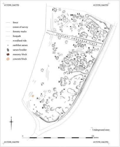
The survey is dominated by stone pits, ranging from simple single-lobed pits with one base to complex multi-lobed features with bases divided by scarps or low banks. They have well-defined, smooth sides. Simple pits are sub-circular or oval on plan ranging from 1.3 m to 7.2 m in diameter. Some of these are shallow crescentic hollows between 0.25 m and 0.35 m deep with better-defined western sides, such as pits [p], [r] and [w], but many are steeply-sided features almost conical in profile up to 0.9 m deep, including pits [b] (19.8 m2), [g] (10.8 m2) and [j] (26.7 m2). The irregular, complex, pits tend to be elongated or sinuous on plan, ranging from 5.2 m to 16.8 m long, largely clustered in the northern and eastern parts of the survey area. They include shallower gully-like features such as pits [M] (20.5 m2) and [N] (37.1 m2) but on the whole are deep and steep-sided such as pits [H] (66.1 m2) and [L] (36.7 m2). The bottoms of those latter pits descend to the east, appearing to have been worked from north-west to south-east, as do pits [E], [U], [V] and [Y]. Pit [E] is 0.4 m deep in the pocket at its south-east end whilst pit [U] reaches a depth of 0.65 m over a distance of 8.9 m.
Pit [v] is cut by pit [w], but digging sequences on the whole caused the extension of pits into multi-lobed features resulting in considerable variety of plan-form and structure. In contrast to the linear arrangement of basal hollows in pits [E], [H], [L], [V] and [Y], for example, the base of pit [G] is stepped down from either end into a deep hollow in the centre. Pits [D] and [F] are more rectangular on plan, comprised of clusters of pits grouped around deep central hollows whilst pit [K] includes a 0.8 m deep pit to its southern side. The largest and most complex extractive features are pit [T], formed of five lobes, and [X] formed of six. Pit [T], partially overlain by a later straight embanked track, is 80.5 m2 on plan, containing banks and spurs of spoil dividing hollows up to 0.75 m deep. Pit [X], 77.7 m2 on plan, descends from west to east in stages demarcated by internal scarps. The north-eastern side of its narrow, steep-sided, eastern arm is partially overlain by linear feature [10].
Simple pits are scattered amongst the more complex and the pits commonly abut with limited evidence for inter-cutting. No pits have extraction ramps and despite the number of pits there are no large discrete spoil heaps in the survey area, only a few small, well-defined stony mounds. Only one surface sarsen survives, with occasional sarsen pieces earth-fast in the sides of pits [j], [t], [u], [X] and [AA]. There are areas of flat open ground, firm underfoot and stony into which it is very difficult to push pegs and surveyors’ arrows. These include the south-west part of the survey area around the concrete block, c. 25 m2 between pits [F] and [H], c. 35 m2 between pits [L] and [M] and c. 180 m2 immediately to the north of the straight embanked track.
In addition to the extraction pits, the survey area includes five finger-dumps running into the quarry from the main woodland ride. Overall there are fourteen finger-dumps in Hursley Bottom, some better formed and more substantial than others, interpreted by Amadio (Citation2011, 39) as causeways for transporting stone out of the quarried area. Their eastern ends meeting the main woodland ride are slightly splayed and the surfaces are approximately level with the ride. Within the measured survey, finger-dumps [14] and [10] are most clearly defined. Finger-dump [13] is similar to [14] but its southern edge spreads imperceptibly into the ground surface. The terminals of finger-dumps [12] and [11] also merge with the ground surface and both include chunks of dumped masonry and concrete. Finger-dump [10], in contrast, is a well-defined embanked feature with high, steeply-sloping sides. Occasional bricks are visible eroding from its sides and there are some large concrete and masonry blocks on and just beyond its northern scarp. Finger-dumps [10], [11] and [12] overly earlier pits, yet the terminal of [12] and southern edge of [11] are also cut by pits.
A 79.9 m-long straight embanked track runs perpendicularly from the main woodland ride towards Forest Lodge to the west. It provides a c. 4.3 m-wide level carriageway with sloped sides. It overlies at least six quarry pits. Although it does not appear to continue into the gardens of Forest Lodge, it is aligned to the sarsen-built house which was described as ‘newly erected’ in 1866 (WSHC, 2027/2/1/911/13). An unmade path to the east of the woodland ride extends the alignment up the steep valley side. The track appears to have been part of the landscaping associated with the house and indicates that previously undocumented quarrying pre-dates the road-stone quarry of 1920.
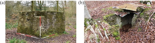
Two important quarry structures survive in the southern part of the survey area. The first is a partially cement-rendered block made of poor-quality concrete including numerous voids, standing 1.4 m tall (). Its upper south-east corner is cut back. The upper surface has two shallow parallel ridges, 0.3 m wide, in which are set four round-section iron pins, 35 mm in diameter. King (Citation1968, 86) identifies this feature as the base for a mechanical stone crusher, which accords with illustrations of such equipment in manufacturers’ advertisements and photographed at work in road-stone quarries (for example Stanier Citation1995, 10, 87). The second structure is a small building cut into the valley side, made of precisely similar concrete covered at ground level by a flat corrugated iron and concrete roof (). The L-shaped space is accessed by a flight of steps to the south-west, leading down to a former doorway providing a baffled entrance to the main chamber, 1.2 m × 1.1 m on plan. It is interpreted by Amadio (Citation2011, 39) as a magazine or explosives store. Unfortunately, no licence permitting Thacker and Johnson to store explosives survives in Wiltshire County Council archives, but the underground space would have met the requirements for a magazine as specified in Order in Council 5 of the Explosives Act (Citation1875), including its distance c. 95 m from the quarry’s powered machinery and the nearest dwellings in the valley bottom below.
FIG. 18 Sarsen quarry infrastructure features in Hursley Bottom, West Woods: (a) the concrete base on which a stone crushing machine was mounted, including a small inset positioned for a wheel to drive a trommel; (b) the underground store cut into the valley side for storing explosive materials (photographs © author).
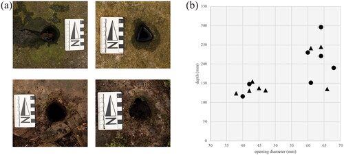
A wider walk-over survey along Hursley Bottom () revealed that Thacker and Johnson had worked from south to north, clearing sarsens from the valley floor. The portion of Stony Copse to the north of the measured survey is very similar, fully worked out with five finger-dumps extending from the main woodland ride into the heavily quarried area. One small group of sarsens survives at Stony Copse’s northern edge, including one split boulder surrounded by an extraction gully and displaying a wedge-pit scar. That stone also has a cylindrical hole cut centrally in its upper surface. The next wood parcel to the north comprises 0.92 ha of well-quarried ground including three finger-dumps. However, numerous large sarsens survive throughout that parcel, including a group of unsplit boulders with extraction gullies and sub-circular or sub-triangular cylindrical holes cut in the centre of their upper surface (). In some examples, the stone surface around the holes is interrupted by small flake scars where material spalled off during the chiselling process, similar to scars around wedge-pit openings in Piggledene. The northernmost sarsens in this wood parcel are also encircled by deep extraction gullies. At least one is split including wedge-pit scars, as is a group of at least seven split blocks close to the main woodland ride. Each block in that group, however, also includes a cylindrical hole cut into its upper surface.
FIG. 19 Charge-holes chiselled into sarsen boulders in Hursley Bottom, West Woods: (a) smaller (top) and larger (bottom) sub-circular and sub-triangular charge-holes; (b) distribution of charge-hole dimensions and sectional forms (photographs © author).
The northern-most part of the walk-over survey comprises a 0.42 ha parcel including a short finger dump with numerous un-worked, earth-fast, sarsens. That parcel thus preserves part of Hursley Bottom’s natural sarsen spread.
A metrical record of a sample of 15 of the cylindrical holes cut into boulder surfaces shows that they cluster into two groups (). The narrower holes are shallower (n = 7, mean width 42 mm, mean depth 134 mm), contrasting with the wider, deeper ones (n = 8, mean width 64 mm, mean depth 213 mm), but the sectional form is distributed across both groups. The ratio of width to depth of all these holes is 1:3 (calculated using the mean values). They are interpreted as charge-holes, intended for setting an explosive charge and fuse to blast each boulder apart.
Contrasting with those wood parcels to the north of the measured survey, the little quarrying evidence in the parcel to its south-west is limited to a few small, shallow, pits and some sarsens split using the 19th century wedging technique. Scattered amongst unworked sarsens, these split boulders were abandoned following primary reduction which includes examples of perpendicular splitting sequences similar to those observed in Piggledene.
DISCUSSION
TASKSCAPE
It is helpful to take a ‘dwelling perspective’ and think of the sarsen quarrying locales as different ‘taskscapes’ (Ingold Citation1993, 152–3), because although the same stone type was being worked, each developed in different contexts. Ingold defines taskscape as the human and social context in which actors complete their tasks, characterising the landscape in which that plays out as emergent through those activities (Ingold Citation1993, 155, 162; [2000] 2011, 325). The concept thus provides the interpretative flexibility in which to explore lived landscapes which, in the case of sarsen working, include multiple dispersed sites of differing technical action occurring at different times.
In this way, archaeological features in the study areas observed in the field and through archive sources are proxies for patterns of activities, including sarsen use, by which taskscapes developed. Rather than seeing quarry features conventionally as economic interventions inscribed onto a static landform to take advantage of a taken-for-granted geological resource, they arise from a network of processes. The form of their landscape incorporates practices of land-ownership, agricultural management and varied industrial behaviours, for example, as well as the geologically-determined properties of bulk minerals more commonly valorised in industrial archaeological studies.
UNDERSTANDING EARTH MATERIALS
In south Buckinghamshire, a landscape approach to recording and interpreting sarsen extraction using remote survey methods provides a small-scale view in which quarry features, digitised from historical Ordnance Survey maps, reveal an intensely extractive landscape. The variety in that landscape is under-served by the economic history of the area, in which aggregates and brick-making dominate the narrative of useful bulk minerals (Moir Citation2006, 4; Benham et al. Citation2003). In the third quarter of the 19th century when the first Ordnance Survey maps were produced, chalk extraction (5.73 ha), gravel pits (1.59 ha) and quarries (1.30 ha) were more significant in the survey area than clay (0.94 ha) by total pit area. The balance between materials derived from these mapped extraction sites changes over the period to the inter-war years, albeit complicated by the increasing numbers of unidentified pits and gaps in map revision coverage. Yet, the significance of these features in the landscape remains, with 135 pits observable in the early 20th century (); on average one pit per square kilometre in the area mapped at that time.
Bulk mineral extraction intensifies when marling is also considered. There are on average nine marl pits per square kilometre in the Walter’s Ash study area. Although these undated features were not necessarily all open concurrently, they nevertheless remind us that materials were very commonly sought from underground to play a part in sustaining the land and the people living with it. Pits in farmland, woodland, at roadsides and even amidst settlements – such as at the Winchmore Hill pottery (BHER 0203000000 Citation2021) and the Kiln Lane brickworks (BHER 0219300000 Citation2021) – would have been a familiar, quotidian, sight. Farmers and minerals workers were negotiating a complex geology, applying knowledge of topography, soils, underlying deposits and bedrock in their daily lives.
Sarsen exploitation occurred in this active extractive landscape. The proximity of pits and quarries to named sarsen-producing locations highlights the complexity of the varied deposits, and the likelihood that people seeking specific products nevertheless encountered mixed materials through their work. Sarsens could be exposed in agricultural contexts including ploughing and marling, or industrial contexts including clay extraction for pottery and brick-making. They were also intentionally prospected for. The growth in the numbers and area of clay pits thus named by the Ordnance Survey in the early 20th century is due in part to the extension of works around Walter’s Ash (). Yet, those pits were opened up principally for sarsen stone.
Stepping aside from the conventional, anthropocentric, industrial archaeological mode in which rock is a natural resource to be exploited is important, because on the Chiltern Hills sarsen boulders are largely unseen. They are not a clear and present material naturally available to the application of an out-of-the-box technology, the stone-cutting tool-set. Rather, the buried boulders themselves indicate where to dig when encountered either accidentally through plough-strike, for example, or purposefully through prospection. Legal relations were then formed between quarrymen and landowners, and between quarrymen and the land including the outright purchase of fields. The latter approach, requiring additional finance, must have been risky given the dispersed nature of the invisible boulders. It further emphasises the specialist knowledge and skill involved in identifying sources.
Evidence at Walter’s Ash indicates that sarsen extraction pits on the Chiltern Hills are likely to be irregular, steep-sided features in the Plateau Drift where the boulders are imbricated with brickearth. By the time the Bristow and Brown’s works were heading towards closure after the Second World War, their mean pit sizes had reached 245 m2 (N = 113) but the majority were under 150 m2 (71, 63%), indicating likely sizes of similar pits on other chalk spurs of the dip-slope. Their area and range of simple to complex lobed plan forms are two-dimensional expressions of the, often deep, solution features in the chalk bedrock in which sarsens are found (Catt Citation2010, 88). These pit forms and their irregular placement – some closely adjacent, others spread apart – indicate the quarrymen’s intimate understanding of the buried deposits. During prospection they relied on the buried boulders to act back: resisting the auguring snipers with which the ground was probed, communicating their presence and extent through information felt, not seen, by the quarrymen. Experiencing and responding to different textures and colours was important throughout the extractive process. Having excavated and removed both sarsens and sandy, clayey brickearth, quarrymen knew that ‘rock’, the pebbly, dark, sticky Clay-with-Flints lining solution pipes (Catt Citation2010, 87–9) marked the extent of the useful, workable and deposit.
It was, therefore, neither necessary nor useful to make use of mechanised open-area excavation. The sarsen quarry conforms to Samuel’s (Citation1977) characterisation of 19th- and early 20th-century mineral workers operating discrete pits traditionally, using labour-intensive, hand-operated machinery. It was not, however, that the quarrymen went unaffected by external technological developments such as powered excavation in which they could not invest, or that they were constrained by long-standing traditions of hand-tool use not to innovate with new technology. On the contrary, they used their ‘knowledgeable practice and practical knowledge’ (Dobres Citation2000, 50), their bodies as much a part of the mechanism as the tools (Ingold [Citation2000] 2011, 304–6, 316, 319), to maintain working traditions that enabled sarsens from pockets of deposits to be transformed into desirable products for both private and public markets.
The movement from 1847 onwards of members of Buckinghamshire stone-cutting families to Wiltshire is conventionally framed in terms of risk, enterprise and innovation. A few young men in their teens and twenties took a chance, seeking the Marlborough Downs’ more easily and cheaply worked surface sarsens: ‘One can hardly imagine the challenge that faced them in a totally new environment where they would have to kick-start an old industry with new methods, and find new markets to sell their stone’ (Crook and Free Citation2011, 17).
Despite the supposed economic attractions of Wiltshire’s sarsens, however, the presumed more difficult and less remunerative industry continued in Buckinghamshire. Furthermore, the results of the detailed analytical survey in Piggledene disrupt aspects of the conventional narrative. A range of features within the Piggledene survey transect indicate that the linear, stadial, sequence of sarsen extraction and cutting described by Free (Citation1948) and King (Citation1968) was not always followed exactly. For example, extraction gullies were not always dug to fully encircle boulders in Piggledene. The sloping valley floor comprises sediments which present particular circumstances to be negotiated in extracting boulders. Subtle variations in boulder surface treatments also contradict the conventional account of the process, especially the lack of chiselled guide-lines on any boulders in the survey transect except stone [6].
Wedge-pit placement further indicates choices in technical action to reduce individual stones. Before discussing the details, it is necessary to touch on the burden (de Kalb Citation1900) of a sarsen boulder. The burden is the line of least resistance to a splitting force: for example, the shortest distance necessary to determine the position of an explosive charge relative to the outer free face of the rock in a quarry wall. The more free faces there are, the smaller the amount of energy required to split a rock or boulder (de Kalb Citation1900, 91), explaining why an extraction gully might be advantageous to breaking up an earth-fast boulder. In addition to burden, stone splits most easily along its rift (usually the bedding plane), and relatively easily through its grain (at right angles to the rift). Recognizing these planes informs choices for reduction sequences, requiring a line of wedges along the rift and, against the rift, wedges that continue down the sides of the stone (Greenwell and Elsden Citation1913, 80–1, 214–8). Sarsen stone, however, is typically homogenous with very poorly-defined bedding structures (Geddes and Walkington Citation2005, 62; Summerfield and Goudie Citation1980, 74). Through its homogeneity, it affords the capability to split in a controlled and even way in potentially any direction.
Gully excavation and wedge placement evident in the Piggledene survey transect contribute to diminishing each boulder’s burden. For example, one wedge placed in the side of stone [28], at its thicker and partially-excavated end, assisted two wedges placed in the upper surface to split this otherwise relatively thin, tabular, boulder. No excavation gully was required around stone group [89]/[100] because the parent boulder was perched on a linear earthwork. The quarrymen’s skill and judgement are also exhibited by stone [34], a large, rounded, boulder also unexcavated, split by four wedges all placed in its eastern side. Three were placed close together and low down to the ground, one further away and higher up. The arrangement conforms in part to Greenwell and Elsden (Citation1913, 214–6) instruction to use multiple wedges, but shows how an intimate knowledge of the properties and behaviour of sarsen reduced the need for any more than were necessary to propagate a split.
A key feature of Wiltshire’s Downland sarsen spreads is the amount of surviving material despite the proliferation of stone exploitation since prehistory. Around 20% of the stone present in the Piggledene survey transect is untouched. The boulders may have been more easily accessible than in Buckinghamshire, but that is not to say that all were suitable for splitting. Many were not selected by the stone-cutters. The abandonment of some partially-split boulders indicates the significance of sarsen’s role in the quarry as well as the judgement exercised by the quarrymen, illustrated by stone [47] and also stone group [131]/[136]; a further example of the stone acting back when small flints inside the matrix spoiled the quarrymen’s intentions and ended in the pragmatic leaving of the partially broken boulder.
Throughout this reduction process, developed in Buckinghamshire and translocated to Wiltshire, both the tools and the materials influenced the actions of the quarrymen. Information was gathered from the way each split occurred during reduction, visually, aurally and hapticly, enabling the stone-cutters to apply know-how and make choices to achieve their objectives (and see Nunez-Garcia Citation2019). Beatrice Searle (Citation2019), for example, writes of the role of listening in the process of stone-splitting,
The stone says what is about to happen and whether it will be cooperative, or not…The stone ceases to make a speak [sic] when it has settled around the plug and feathers and is ready to continue. If I ignore this communication and resume the process too soon, the stone will almost certainly rip out a chunk of itself along the path of least resistance.
The archaeological features demonstrate that decisions in Piggledene were made in relation to the burden and the matrix of each sarsen boulder. Attending to the burden was more important than following a prescribed working method, as shown by surface treatments, wedge-pit placement and the choice whether or not to excavate gullies. In some instances, such as stone group [89]/[100], the quarrymen took advantage of the lie of the land to assist them. The homogeneity of the matrix played a part in how predictably and cleanly each sequence of perpendicular splits would execute. These are subtle features, but close examination of such details reveals the complexity of the relationship between material, quarryman and technology.
Accounts of the revolutionary introduction to Wiltshire of specialist sarsen-cutting tools and techniques from Buckinghamshire only describe the wedging method of stone-reduction. Yet plug-and-feather holes cut into sarsens in Piggledene are noted by Stanier (Citation2000, 43) and were recorded during the survey. By the time Buckinghamshire stone-cutters were established in Wiltshire after 1847, the use of plug-and-feather had become widespread in stone quarrying. There are no phase relationships between boulders in Piggledene split by different methods, but the probably 19th-century walls enclosing the northern yard to Pickledean Barn comprise sarsen blocks predominantly split by plug-and-feather, with very few examples of wedged stone.
The possible contemporaneity of wedging and plug-and-feather, or perhaps earlier use of plug-and-feather before the 1840s, also contradicts the conventional narrative of Buckinghamshire innovators introducing a tool-set uniquely designed to split sarsen stone. It is important to bear in mind that descriptions of stone-cutting in Wiltshire originate with Free (Citation1948, Citation1950), grandson of a stone-cutter who moved from Buckinghamshire, and are augmented a generation later by King (Citation1968) who drew on local oral history. That published narrative privileges the knowledge of a few individuals without reference to local practices of sarsen use pre-dating the 1840s. Furthermore, the generalisations in those accounts, brought into question by this fieldwork, obscure the potential for experimentation, innovation and change by the skilled quarrymen.
The same selectivity revealed in Piggledene is evident in Hursley Bottom, where the distribution of sarsens with wedge-pit scars across the overall walk-over survey area now provides evidence for traditional splitting pre-dating the road-stone quarry of 1920. The activity may date to as early as the 1860s and the creation of Forest Lodge. As in Piggledene, some boulders were left untouched whilst some partially split boulders were abandoned. Charge-holes were later chiselled out of some of the partially split sarsens lying to the north of the Hursley Bottom measured survey area, suggesting that the earlier stone-cutters had taken their pick of boulders along the valley before Thacker and Johnson began their less discriminate extraction.
On the face of it, Thacker and Johnson’s completely different approach to sarsen exploitation was driven by the need to produce large volumes of consistently sized rubble for road-stone. There is, it seems, no artisanal skill involved in making the stone chunks and chips, only chemically-assisted brute force to shatter the boulders in primary reduction, powered machinery to crush the fragments, and a set of procedures to follow to meet the legislated requirements for operating with explosives. To an extent this is borne out, by the almost complete clearance of sarsens from Stony Copse and details such as the buried magazine carefully placed at distance from the working area and nearby residences. Nevertheless, even though the road-stone quarry was mechanised, evidence in Hursley Bottom indicates that objectives were as, if not more, important than rules in conditioning extractive practices, making this a taskscape in Ingold’s sense ([2000] 2011, 325).
The mix of simple and complex lobed pits dug out of Head deposits in the valley bottom are reminiscent of the, albeit generally larger, sarsen and clay pits at Walter’s Ash in Buckinghamshire. The Hursley Bottom measured survey results suggest that the superficial deposits tend to lie thickest to the eastern side, indicated by the greater complexity and depth of numerous pits and the downslope linear arrangement of extractive pits. That would be consistent with geological sections observed in test pits dug across nearby Clatford Bottom by Clark, Lewin, and Small (Citation1967, 27–30), which also exposed solution pipes containing sarsens. The base of Hursley Bottom may be similar, and it should be noted that none of its quarry pits contain standing water in the Winter and must be freely draining, presumably in the underlying Chalk.
The size, complexity and distribution of the extraction pits has, however, as much to do with quarrying decisions as the mere geological presence of available stone. Although boulder reduction was mechanised, pit forms in the worked-out area of Stony Copse indicate that excavation was not. Steep pit sides and multi-lobed shapes including internal scarps give the impression that sarsens were chased through the deposit, but that was not an indiscriminate exercise resulting in a fully open-area excavation. The well-defined pit edges show that digging stopped when no more sarsens were clustered in the deposit. The absence of extraction ramps suggests that while simple lifting gear may have been required to remove material from the deepest, steep-sided pits, much of the movement of broken sarsen out of the pits must have been carefully by hand onto vehicles (whether barrows or carts) on the finger-dumps for transport to the stone crusher.
The use of extraction gullies and placement of charge-holes further indicates choices that were made to prepare the ground and reduce individual boulders. Numerous sarsens remaining to the north of the measured survey area were released from enclosing deposits by encircling gullies, firstly reducing the burden and secondly assisting the removal of broken stone. The group of closely-positioned boulders treated in this way which also have charge-holes indicate that only as many boulders as could be shattered in one session were prepared, reducing the amount of risky rubbish and water that might enter the holes before use.
The aim of primary reduction by blasting is to shatter rock such that it can be collected and moved on to the next processing stage. The correct amount of charge required to shatter a particular type of rock can be found by experiment and then reduced in proportion to the number of free rock faces: assuming a boulder with a gully has in effect five free faces, then two-fifths of the charge required to break sarsen will be sufficient per boulder, set in a centrally-placed charge-hole that roughly equalises the burden (de Kalb Citation1900, 91–5; Greenwell and Elsden Citation1913, 299). If the stone is homogenous, then the weight of the necessary charge will be proportionate to the cube of the burden (Burgoyne Citation1895, 16) and a suitably-sized charge-hole can be cut out to take the explosive, tamping and fuse. ‘When done judiciously’ Burgoyne writes, ‘the report will be trifling, and the mass will be seen to be lifted, and thoroughly fractured, rent, or thrown over, without being forcibly projected’ (1895, 8). Hursley Bottom charge-holes vary in width and depth but the relationship between these dimensions is regularly in the ratio 1:3, demonstrating the knowledge born of experience that Thacker and Johnson had accrued during their clearance of Stony Copse as they worked through Hursley Bottom.
In order to transport shattered sarsen to the stone crusher, finger-dumps were built up from the main woodland ride into the quarried area. Thacker and Johnson’s intentionality is demonstrated by finger-dump placement at fairly regular intervals including in wood parcels where boulders had yet to be prepared for clearance, and the carefully built-up eastern ends having splayed approaches to the ride. The irregularity of the plan forms of, for example, finger-dumps [11] and [12] as they were expanded and used indicates a more haphazard process over the duration of tasks in the quarry. The relationship between these two finger-dumps and adjacent extraction pits reveal that Thacker and Johnson did not clear sections of the wood parcels systematically. Finger-dump [11] was made in two spurs to access pits being opened up towards the middle of the wood parcel, and pit [K] was extended back into the embanked feature as sarsens were removed. Again, the quarrymen’s objectives were important factors in shaping the landscape forms of the valley bottom, rather than pursuing a scientific approach to the most efficient exploitation of its natural resources.
The shattered sarsen was moved to the stone crusher, elevated on its concrete base and standing in a relatively open part of Stony Copse. The base’s cut-back south-east corner indicates where a belt passed from the crusher to a small wheel driving the trommel, a kind of cylindrical sieve into which crushed stone dropped out of the raised crusher jaws. The trommel assisted the separation of differently-sized stone pieces, and allowed too large items to be returned to the crusher for further processing. Both the construction of the concrete base and the positioning of the crusher and trommel are expedient yet calculated: the concrete mix is poor, the trommel position is towards the southern access track permitting crushed stone to be easily removed off-site, whilst the area behind the base is flat enough for a portable engine to stand, powering the machinery.
In this taskscape, the context of sarsen exploitation includes not only rules arising from the Explosives Act (Citation1875), treatises on how to blast rock and the demands of a commercial contract. The messy business of dealing with the valley deposits and the quarrymen’s knowledge of the behaviours of sarsen stone are also part of the pattern of technical actions which this landscape incorporates. Unlike at Walter’s Ash, the immediate presence of boulders is obvious from the surface spread populating the valley bottom. Yet the thick Head concealed further valuable material which would only have become apparent in the process of removing the visible boulders. Each extractive event embodied what Ingold (Citation1993, 157) identifies as both something of the past and a potentiality for the future: removing one boulder perhaps to reveal another, until a cluster was worked out in an objective-led task-orientation. The proliferation of sarsen was thus revealed through the technical actions adopted in the quarry.
CONCLUSION
In each of these quarries, the same type of stone was exploited to make very different products. Properties of sarsen stone afforded this flexibility. The size, volume and frequency of the boulders provided quantities of material to support an albeit short-term road-stone contract, but also to service longer-term quarrying to make carefully proportioned setts, kerbs, dimension stone, ashlars and other shaped products. Sarsen’s homogeneity, hardness and brittleness enabled both precise and controlled splitting into those regular forms, and reduction into rubble and chips, as though it was a different material depending on the technical action applied to it. Quarrymen using dissimilar reduction methods nevertheless experienced some of the same behaviours of the stone: its tendency to flake and spall when wedge-pits or charge-holes were chiselled into boulder surfaces, for example, or its propensity to cluster in superficial deposits revealed through excavation, reminding us of sarsen’s identity as ‘breeding stone’.
The different methodologies adopted in this study are complimentary, enabling the exploration of relations between people, materials and technology at different scales. Both the intensive and extensive approaches taken to recording and analysing these separate quarries show that a great deal of information can be gleaned even from sites of surface extraction. It is worth paying attention to the smallest of details which analytical earthworks survey and metrical recording of tool-marks can capture.
In Piggledene, an interplay between skilled human action, the sarsen-cutting toolset and material properties of sediments and stone is revealed, through subtleties in how the reduction process was applied to individual boulders. Plug-and-feather stone-working practices are identified in the valley, hinting at an alternative or more complex story obscured by the conventional narrative of a uniquely-successful sarsen-working technique introduced to Wiltshire by outsiders. A landscape approach using remotely-sensed data and other archive material throws light on quarry practices at Walter’s Ash despite the redevelopment of the yards. There, experience and knowledge of deposits contributed to the maintenance of traditional quarrying methods. In Hursley Bottom the use of explosives and mechanised stone-breaking still involved making objective-led decisions about technical actions based on understanding of materials. Thacker and Johnson were ‘coping with machines’ (Ingold [Citation2000] 2011, 332), learning how charge-holes needed to be cut based on the burden of individual sarsens and laying out their infrastructure partly because of regulation and partly for convenience but then adapting it, for example re-working their finger-dumps in response to the actualities of the valley’s deposits. Landscape forms recorded in the survey arose from the execution of tasks towards objectives, showing the interplay between a commodity perspective directed towards the market for stone and a dwelling perspective focussing on skilled social agents at work (Ingold [Citation2000] 2011], 332–3).
The complexity of the relationships between people, materials and technology which concerns Conneller (Citation2011) is revealed through close attention to the materials and technical actions of all three taskscapes. Despite the contrasting methodological scales employed in the study areas, the significance of bodily engagement with the materials encountered in the landscape is evident. That worked at both the macro level of engagement with the particular deposits in which sarsens can be found, and at the micro level of engagement with individual boulders as choices were made in reduction processes. Although all three sites made commercial products, to view them through a purely economic lens or to treat these stone-working technologies as functional absolutes would be to diminish the roles of both active human agents and the materials with which they worked.
Reports on the fieldwork carried out in Piggledene and Hursley Bottom are deposited at the Wiltshire Historic Environment Record. Data (all features, all periods) transcribed in the Walter’s Ash study area are deposited at the Buckinghamshire Historic Environment Record.
This paper is published with financial assistance from the University of Reading. This work was supported by the Arts and Humanities Research Council (grant number AH\L503939\1) through the South, West and Wales Doctoral Training Partnership.
| ABBREVIATIONS | ||
| BA | = | Buckinghamshire Archives |
| BHER | = | Buckinghamshire Historic Environment Record |
| NHLE | = | National Heritage List for England |
| SWOP | = | Sharing Wycombe’s Old Photographs (High Wycombe Library) |
| WSHC | = | Wiltshire and Swindon History Centre |
ACKNOWLEDGEMENTS
I thank Dr Elaine Jamieson and Dr Krystyna Truscoe for their invaluable fieldwork assistance, and Forestry England and The National Trust for access, in Wiltshire. Fieldwork equipment including Total Station and GNSS were kindly provided by the University of Reading. Members of the Historic England Archaeological Investigation and Mapping Team, in particular Fiona Small, enabled me to complete the Buckinghamshire transcription. Historic England Archive kindly provided access to aerial photography. Access to other archive material and records was enabled by British Geological Survey, Buckinghamshire County Museum, Buckinghamshire Archives and both the Buckinghamshire and Wiltshire Historic Environment Records. I would also like to thank the two anonymous reviewers whose encouraging and useful comments enabled me to make improvements to my original manuscript.
BIBLIOGRAPHY
MANUSCRIPT SOURCES
- 1225/73, Conveyancing papers relating to West Woods estate in West Overton, Fyfield and Preshute including sale particulars with plans 1928 and 1931.
- 2027/2/1/911/13, Merriman, Porter and Long solicitors (Marlborough), sales particulars, Cottages in Angel Yard, Marlborough and at Fosbury and Lockeridge Dean in Overton, and Clatford Park in Preshute, 1866.
- 2943B/2/50, Letters to James Long, 7th baronet later Sir James Tylney Long.
- CH 1/T/24, Lease (with counterpart) for 54 years commencing 1736, 21 Oct 1730.
- D-CN/9/5/1/21, Counterpart Lease for fifteen years, 10 Jun 1740.
- D-X/935, Copy photographs of Brown Brothers and Bristows brickyards at Walter’s Ash in Lacey Green, 1930–1956.
- F1/100/6/6, Wiltshire County Council Roads and Bridges Committee.
- RHW:50634, View of a stone-mason, Mr Ralph Turner, at work on a small block of stone supported on an upturned drum (1950).
DATABASE SOURCES
- “Aylesbury Urban District Council.” 1912, February 17. Bucks Herald. https://www.britishnewspaperarchive.co.uk
- “Amersham.” 1925, October 3. Bucks Herald. https://www.britishnewspaperarchive.co.uk
- BHER 0203000000. 2021. “Winchmore Hill Pottery.” Accessed January 14, 2021. https://heritageportal.buckinghamshire.gov.uk/Monument/MBC6006
- BHER 0219300000. 2021. “Kiln Lane Brickworks.” Accessed January 14, 2021. https://heritageportal.buckinghamshire.gov.uk/Monument/MBC6444
- BHER 0505600000. 2021. “Honor End Lane, Prestwood.” Accessed January 14, 2021. https://heritageportal.buckinghamshire.gov.uk/Monument/MBC13141
- GB Historical GIS Project. 2009–2017a. “Hughenden AP/CP through Time. Population Statistics. Total Population.” A Vision of Britain through Time (University of Portsmouth). Accessed July 28, 2021. https://www.visionofbritain.org.uk/unit/10065320/cube/TOT_POP
- GB Historical GIS Project. 2009–2017b. “West Overton CP/AP through Time. Population Statistics. Total Population.” A Vision of Britain through Time (University of Portsmouth). Accessed July 28, 2021. https://www.visionofbritain.org.uk/unit/10410824/cube/TOT_POP
- NHLE 1160234. 2017. “Denner Hill Farmhouse.” Historic England. Accessed May 1, 2017. https://www.historicengland.org.uk/listing/the-list/list-entry/1160234
- NHLE 1332051. 2017. “Pair of Barns Adjoining to West of Denner Hill Farmhouse.” Historic England. Accessed May 1, 2017. https://www.historicengland.org.uk/listing/the-list/list-entry/1332051
- “Notes and News: Local and General.” 1911, October 7. Bucks Herald. https://www.britishnewspaperarchive.co.uk
PUBLISHED SOURCES
- Adams, J. 1870. “Sarsens.” Transactions of the Newbury District Field Club 1: 104–109.
- Alfrey, J. 2006. “The Language of Its Builders: Stone in the Vernacular of Rural Wales during the Nineteenth Century.” Vernacular Architecture 37 (1): 54–60. doi:10.1179/174962906X158255.
- Allen, J. R. L. 2015. Kerbside Geology in Reading, Berkshire. Aspects of Historical Archaeology in the Explanding Town, c1840-1914. BAR British Series 619. Oxford: Archaeopress.
- Allen, J. R. L. 2017. “Geological Resources and Their Exploitation in the Berkshire Chalklands of the Later Nineteenth Century: A First Survey.” Landscape History 38 (1): 67–80. doi:10.1080/01433768.2017.1322271.
- Amadio, L. 2011. West Woods, Wiltshire. An Archaeological Survey. Devizes: Wiltshire Archaeological and Natural History Society. doi:10.5284/1018072.
- Anon. 1908. “The Grey Wethers Preservation Fund.” Wiltshire Archaeological Magazine 35 (109): 497–501.
- Bedford, J., T. Pearson, B. Thomason, and A. Oswald. 2016. Traversing the Past. The Total Station Theodolite in Archaeological Landscape Survey. Swindon: Historic England.
- Benham, A. J., A. N. Morigi, A. J. M. Barron, D. G. Cameron, N. A. Spencer, M. H. Shaw, A. J. Bloodwirth, D. J. Evans, G. K. Lott, and D. E. Highley. 2003. “Mineral Resource Information in Support of National, Regional and Local Planning.” Buckinghamshire and Milton Keynes. British Geological Survey/Office of the Deputy Prime Minister (Keyworth: HMSO). https://www.bgs.ac.uk/mineralsUK/planning/resource.html
- Born, A. 1988. “Blue Slate Quarrying in South Devon: An Ancient Industry.” Industrial Archaeology Review 11 (1): 51–67. doi:10.1179/iar.1988.11.1.51.
- Bovill, W. 1903. “The Buried Stones on the Chilterns.” The World’s Work, September 1903, 367–369.
- Bowen, H. C., and I. F. Smith. 1977. “Sarsen Stones in Wessex: The Society’s First Investigations in the Evolution of the Landscape Project.” The Antiquaries Journal 57 (2): 185–196. doi:10.1017/S0003581500031152
- Brentnall, H. C. 1946. “Sarsens.” Wiltshire Archaeological and Natural History Magazine 51: 419–439.
- Britton, J., ed. 1847. The Natural History of Wiltshire by John Aubrey F.R.S. Written between 1656 and 1691. Newton Abbot: David and Charles.
- Brück, J. 2006. “Fragmentation, Personhood and the Social Construction of Technology in Middle and Late Bronze Age Britain.” Cambridge Archaeological Journal 16 (3): 297–315. doi:10.1017/S0959774306000187
- Burgoyne, J. F. 1895. A Treatise on the Blasting and Quarrying of Stone for Building and Other Purposes. London: Lockwood and Son.
- Burtonwood, G. 1995. Denner Hill Stone. Halton: Buckinghamshire County Museum Archaeological Service.
- Catt, J. 2010. “Neogene deposits and Early Landscape Development.” In Hertfordshire Geology and Landscape, edited by J. Catt, 79–117. Welwyn Garden City: Hertfordshire Natural History Society.
- Clark, M. J., J. Lewin, and R. J. Small. 1967. The Sarsen Stones of the Marlborough Downs and Their Geomorphological Implications. Southampton: Department of Geography, University of Southampton.
- Colfer, N. 2010. “Between the Sea and the Land: Coastal Limestone Quarries on the Hook Peninsula, Co. Wexford.” The Journal of Irish Archaeology 19: 113–130.
- Conneller, C. 2011. An Archaeology of Materials: Substantial Transformations in Early Prehistoric Europe. Abingdon: Routledge.
- Coppack, J. T. 1962. The Chilterns. A Description of the O.S. One-Inch Sheet 159. Sheffield: The Geographical Association.
- Cordiner, R. J., and A. Brook. 2017. Building Stone Atlas of Sussex. Worthing: Verite
- Crook, M. L., and I. E. T. Free. 2011. Grey Wethers. The Free Family in Marlborough and the Upper Kennet Valley c1847-1998. Wiltshire, UK: Privately Published.
- Crossley, D. 1990. Post-Medieval Archaeology in Britain. Leicester: Leicester University Press.
- Davies, A., and A. H. J. Baines. 1953. “A Preliminary Survey of the Sarsen and Puddingstone Blocks of the Chilterns.” Proceedings of the Geologists’ Association 64 (1): 1–9, IN1. doi:10.1016/S0016-7878(53)80014-3
- de Kalb, C. 1900. Manual of Explosives: A Brief Guide for the Use of Miners and Quarrymen. Toronto: The Ontario Bureau of Mines.
- Dewey, H., and C. E. N. Bromehead. 1915. The Geology of the Country around Windsor and Chertsey. London: HMSO.
- Dobres, M.-A. 2000. Technology and Social Agency. Outlining a Practice Framework for Archaeology. Oxford: Blackwell.
- Ellis, G. A., and C. Jamison. 1925. “Hughenden.” In The Victoria County History of the County of Buckingham, edited by W. Page, 57–62. London: The St Catherine Press.
- Entwistle, D. C., Hobbs, P. R. N., Northmore, K. J., Kipper, J. S., Raines, M. R., Self, S. J., Ellison, R. A. and Jones, L. D. 2013. Engineering Geology of British Rocks and Soils - Lambeth Group, Engineering Geology Directorate Open Report. Keyworth: British Geological Survey.
- Evans, S. 2019. Historic England Archaeological Investigation and Mapping (Formerly National Mapping Programme) Standards Technical Review. Swindon: Historic England.
- Explosives Act. 1875. (38 Vict. C.17), and the Orders in Council and Orders of the Secretary of State made under that Act; with remarks upon the Explosives Substances Act, 1883 (46 Vict. C.3). London: Her Majesty’s Stationery Office.
- Fowler, P., and I. Blackwell. 1998. The Land of Lettice Sweetapple. Stroud: Tempus.
- Free, D. W. 1948. “Sarsen Stones and Their Origin.” Wiltshire Archaeological and Natural History Magazine 52: 338–344.
- Free, D. W. 1950. Marlborough and District: An Original Peep into the Past. Wiltshire, UK: Marlborough.
- Freeman, R. A. 2001. Bases of Bomber Command Then and Now. London: Battle of Britain International.
- Frieman, C. J. 2023. “Innovation, Continuity and the Punctuated Temporality of Archaeological Narratives.” In Everywhen: Australia and the Language of Deep History, edited by A. McGrath, L. Rademaker, and J. Troy. Lincoln, NE: University of Nebraska Press.
- Geddes, I. 2000. Hidden Depths. Wiltshire’s Geology and Landscapes. 2nd ed. Trowbridge: Ex Libris Press.
- Geddes, I., and H. Walkington. 2005. “The Geological History of the Marlborough Downs.” In The Avebury Landscape. Aspects of the Field Archaeology of the Marlborough Downs, edited by G. Brown, D. Field, and D. McOmish, 58–65. Oxford: Oxbow Books.
- Gillings, M., J. Pollard, D. Wheatley, and R. Peterson. 2008. Landscape of the Megaliths. Excavation and Fieldwork on the Avebury Monuments, 1997-2003. Oxford: Oxbow Books.
- Green, C. 2016. “The Exploitation of Silcretes (Sarsen and Puddingstone) in England and Normandy since Stonehenge.” Proceedings of the Geologists’ Association 127 (3): 349–358. doi:10.1016/j.pgeola.2015.12.002.
- Green, D., and S. Kidd. 2006. Buckinghamshire and Milton Keynes Historic Landscape Characterisation. Aylesbury: Buckinghamshire County Council.
- Greenwell, A., and J. V. Elsden. 1913. Practical Stone Quarrying. A Manual for Managers, Inspectors, and Owners of Quarries, and for Students. London: Crosby Lockwood and Sons.
- Gwyn, D. 1999. “Power Systems in Four Gwynedd Slate Quarries.” Industrial Archaeology Review 21 (2): 83–100. doi:10.1179/iar.1999.21.2.83.
- Hicks, D. 2016. “The Temporality of the Landscape Revisited.” Norwegian Archaeological Review 49 (1): 5–22. doi:10.1080/00293652.2016.1151458
- Ingold, T. 1993. “The Temporality of the Landscape.” World Archaeology 25 (2): 152–174. doi:10.1080/00438243.1993.9980235
- Ingold, T. 2000. 2011. The Perception of the Environment. Abingdon: Routledge.
- Jamieson, E., S. Ainsworth, M. Bowden, D. McOmish, and T. Pearson. 2017. Understanding the Archaeology of Landscapes. A Guide to Good Recording Practice. 2nd ed. Swindon: Historic England.
- Johnson, M. 2007. Ideas of Landscape. Oxford: Blackwell.
- Jones, M., and C. F. Green. 2013. “A Romano-British Puddingstone Quarry in the Hertfordshire Chilterns.” Proceedings of the Geologists’ Association 134: 86–106.
- Kelly’s Directory of Buckinghamshire. 1911. London: Kelly’s Directories.
- King, N. E. 1968. “The Kennet Valley Sarsen Industry.” Wiltshire Archaeological and Natural History Magazine 63: 83–93.
- Knapp, A. B. 1998. “Social Approaches to the Archaeology and Anthropology of Mining.” In Social Approaches to an Industrial past. The Archaeology and Anthropology of Mining, edited by A. B. Knapp, V. C. Piggott, and E. W. Herbert, 1–23. London: Routledge.
- Lamesa, A. 2017. “If Techniques Help to Date a Monument…Three Case Studies.” In Cappadocia – Hypogea 2017. Proceedings of the International Congress of Speleology in Artificial Cavities, edited by M. Parise, C. Galeazzi, R. Bixio, and A. Yamac, 58–64. Kapadokya: Dijital Dusler.
- Le Neve Foster, C. 1894. A Textbook of Ore and Stone Mining. London: Charles Griffin.
- Leroi-Gourhan, André. 1993. Gesture and Speech. Translated by Anna Bostock Berger. Cambridge, MA: MIT Press.
- Lim, J., J. Clark, and G. Linares-Matás. 2020. “Subsurface Delineation of Doline Features Associated with Pleistocene Clay-with-Flints Deposits in the Chilterns: Implications for British Palaeolithic Archaeology.” Journal of Archaeological Science: Reports 34: 102665. doi:10.1016/j.jasrep.2020.102665.
- Linsley, S. M. 1990. “Millstones from Brockholm Quarry, Northumberland.” Industrial Archaeology Review 12 (2): 178–184. doi:10.1179/iar.1990.12.2.178.
- Mate, G. 2013. “Mount Shamrock: A Symbiosis of Mine and Settlement.” International Journal of Historical Archaeology 17 (3): 465–486. doi:10.1007/s10761-013-0229-y
- Moir, J. 2006. Chilterns Building Design Guide. Chilterns Brick. Supplementary Technical Note. Chinnor: Chilterns Conservation Board.
- Morleghem, D. 2016. "Production et diffusion des sarcophages de pierre de l’Antiquité tardive et du haut Moyen Âge dans le Sud du Bassin parisien." PhD diss., University of Tours.
- Murton, J. B., and C. K. Ballantyne. 2017. “Periglacial and Permafrost Ground Models for Great Britain.” In Engineering Geology and Geomorphology of Glaciated and Periglacial Terrains, Engineering Geology Special Publications, edited by J. S. Griffiths and C. J. Martin, 501–597. London: The Geological Society.
- Nash, D. J., and J. S. Ullyott. 2007. “Silcrete.” In Geochemical Sediments and Landscapes, edited by D. J. Nash and S. J. McLaren, 95–143. Oxford: Blackwell Publishing.
- National Heritage List for England (Historic England). Historic Buildings List Entries, England (UK). https://historicengland.org.uk/listing/the-list/
- Newman, P., ed. 2016. The Archaeology of Mining and Quarrying in England: A Research Framework. Matlock: The National Association of Mining History Organisations.
- Nunez-Garcia, A. 2019. “‘Crafting Agency’: An Inquiry into Symmetrical Human-Thing Assemblages.” Archaeological Review from Cambridge 34 (2): 26–43.
- Oliver, R. 1993. Ordnance Survey Maps. A Concise Guide for Historians. London: The Charles Close Society.
- Orange, H. 2008. “Industrial Archaeology: Its Place within the Academic Discipline, the Public Realm and the Heritage Industry.” Industrial Archaeology Review 30 (2): 83–95. doi:10.1179/174581908X347292.
- Osborne White, H. J. 1907. The Geology of the Country around Hungerford and Newbury. London: His Majesty’s Stationery Office.
- Osborne White, H. J. 1909. The Geology of the Country around Basingstoke. London: His Majesty’s Stationery Office.
- Osborne White, H. J. 1912. The Geology of the Country around Winchester and Stockbridge. London: His Majesty’s Stationery Office.
- Osborne White, H. J. 1925. The Geology of the Country around Marlborough. London: His Majesty’s Stationery Office.
- Pevsner, N., and E. Williamson. 1994. The Buildings of England. Buckinghamshire. London: Penguin.
- Pfaffenberger, B. 1992. “Social Anthropology of Technology.” Annual Review of Anthropology 21 (1): 491–516. doi:10.1146/annurev.an.21.100192.002423
- Potter, J. F. 1998. “The Distribution of Silcretes in the Churches of the London Basin.” Proceedings of the Geologists’ Association 109 (4): 289–304. doi:10.1016/S0016-7878(98)80022-9.
- Prestwich, J. 1854. “On the Structure of the Strata between the London Clay and the Chalk in the London and Hampshire Tertiary Systems. Part II: The Woolwich and Reading Series.” Quarterly Journal of the Geological Society 10 (1-2): 75–138. doi:10.1144/GSL.JGS.1854.010.01-02.10.
- Priest, St. J. 1810. General View of the Agriculture of Buckinghamshire. London: Richard Phillips.
- Quarries Act. 1894. (57 & 58 Vict. C.42). London: Her Majesty’s Stationery Office.
- Rastell, J. 1530. The Pastyme of People: The Cronycles of Dyuers Realmys and Most Specyally of the Realme of Englond. London: John Rastell.
- Reed, M. 1979. The Buckinghamshire Landscape. London: Hodder and Stoughton.
- Rockwell, P. 1993. The Art of Stoneworking: A Reference Guide. Cambridge: Cambridge University Press.
- Rupert Jones, T. 1886. “History of the Sarsens.” Wiltshire Archaeological and Natural History Magazine 23 (68): 122–154.
- Samuel, R. 1975. ““Quarry Roughs”: Life and Labour in Hedington Quarry, 1860-1920. An Essay in Oral History.” In Village Life and Labour, edited by R. Samuel, 139–263. London: Routledge.
- Samuel, R. 1977. “Mineral Workers.” In Miners, Quarrymen and Saltworkers, edited by R. Samuel, 3–97. London: Routledge and Keegan Paul.
- Scard, A. M. 1989. “The Development and Changing Organisation of Shropshire’s Quarrying Industry: 1750-1900.” Industrial Archaeology Review 11 (2): 171–186. doi:10.1179/iar.1989.11.2.171.
- Scott-Brown, S. 2017. “The Secret Life of Headington Quarry. People’s History in the Field.” In The Histories of Raphael Samuel, a Portrait of the People’s Historian, edited by S. Scott-Brown, 131–162. Canberra: ANU Press.
- Searle, B. 2019. “Learning a Stone.” The Clearing December 3. https://www.littletoller.co.uk/the-clearing/essay/learning-a-stone-by-beatrice-searle/
- Sheahan, J. J. 1872. History and Topography of Buckinghamshire. London: Longman, Green, Longman and Roberts.
- Sherlock, R. L. 1919. “Excursion to Walter’s Ash, Buckinghamshire, Saturday, July 26th, 1919." Proceedings of the Geologists’ Association 30: 191–193.
- Sherlock, R. L. 1922. The Geology of the Country around Aylesbury and Hemel Hempstead. London: His Majesty’s Stationery Office.
- Sherlock, R. L., and A. H. Noble. 1912. “On the Glacial Origin of the Clay-with-Flints of Buckinghamshire and on a Former Course of the Thames.” Quarterly Journal of the Geological Society 68 (1-4): 199–212. doi:10.1144/GSL.JGS.1912.068.01-04.13.
- Sherlock, R. L., and A. H. Noble. 1922. The Geology of the Country around Beaconsfield. London: His Majesty’s Stationery Office.
- Spicer, E. C. 1905. “Sarsen-Stones in a Claypit.” Quarterly Journal of the Geological Society 61 (1-4): 39–42. doi:10.1144/GSL.JGS.1905.061.01-04.07.
- St John Hope, W. H. 1913. Windsor Castle: An Architectural History. London: Country Life.
- Stanier, P. 1995. Quarries of England and Wales. An Historic Photographic Record. Truro: Twelveheads Press.
- Stanier, P. 2000. Stone Quarry Landscapes. The Industrial Archaeology of Quarrying. Stroud: Tempus.
- Stukeley, W. 1743. Abury – A Temple of the British Druids, with Some Others, Described, Etc. London: n.p.
- Summerfield, M. A., and A. S. Goudie. 1980. “The Sarsens of Southern England: Their Palaeoenvironmental Interpretation with Reference to Other Silcretes.” In The Shaping of Southern England, edited by D. K. C. Jones, 71–100. London: Academic Press.
- Thomas, I. 2016. “Bulk Minerals.” In The Archaeology of Mining and Quarrying in England. A Research Framework for the Extractive Industries in England, edited by P. Newman, 33–83. Matlock: The National Association of Mining History Organisations.
- Trueman, M. R. G. 1992. “The Langcliffe Quarry and Limeworks.” Industrial Archaeology Review 14 (2): 126–144. doi:10.1179/iar.1992.14.2.126.
- Truscoe, K. 2017. Silchester Iron Age Evirons Project: Aerial Photography and Lidar Survey Results. Swindon: Historic England.
- Ullyott, J. S., D. J. Nash, C. A. Whiteman, and R. N. Mortimore. 2004. “Distribution, Petrology and Mode of Development of Silcretes (Sarsens and Puddingstones) on the Eastern South Downs, UK.” Earth Surface Processes and Landforms 29 (12): 1509–1539. doi:10.1002/esp.1136.
- Whitaker, K. A. 2019. “Sarsen Stone Quarrying in Southern England: An Introduction.” In Mining and Quarrying in Neolithic Europe. A Social Perspective, edited by A. Teather, P. Topping, and J. Baczkowski, 101–113. Oxford: Oxbow Books.
- Whitaker, K. A. In preparation. “Sarsen Stone Cutters in Buckinghamshire and Wiltshire: Investigating Communities of Practice through Census Records.”
- Whitaker, W. 1864. The Geology of Parts of Middlesex, Hertfordshire, Buckinghamshire, Berkshire and Surrey. London: HMSO.
- Willies, L., N. Redvers-Higgins, and I. Wain, eds. 2011. Finished Labour of a Thousand Hands’. The Archaeology of the Combe down Stone Mines, Bath, Somerset. Oxford: Oxford Achaeology.
- Woodward, H. B. 1891. “Note on a Greyweather at Bayswater.” Geological Magazine 8 (3): 119–121. doi:10.1017/S0016756800186261.
- Woodward, H. B. 1905. “Geology.” In The Victoria County History of the County of Buckingham., edited by W. Page, 1–24. London: James Street.
- Woodward, H. B., and R. S. Herries. 1905. “Excursion to the Chilterns: Saturday, June 3rd, 1905.” Proceedings of the Geologists’ Association 19 (3): 147–149. doi:10.1016/S0016-7878(05)80035-5.