
Abstract
A worked bone artefact from Stonelands Cave has been radiocarbon dated to the Roman period. This is the first published record of any archaeological material from the site and increases the number of cave sites in the southern Yorkshire Dales known to have been utilised during such times.
Keywords:
Stonelands Cave is a 600 m long cave system situated beneath the north-eastern flank of the glaciated trough of Littondale between Arncliffe and Litton in the south eastern Yorkshire Dales (Brook et al. Citation1988, 103). The cave entrance is situated above the valley floor within the Cove Limestone Member of the Malham Formation (Arthurton, Johnson, and Mundy Citation1988).
The cave consists of a large (3 m high by 8 m wide) entrance leading into a flat roofed gravel and cobble floored chamber across which a stream flows before sinking into the floor sediments. At the inner end of the entrance chamber a 2 m climb up leads to a 2 m by 1.5 m stream passage which sumps after 180 m. The source of the stream is unknown and the destination of the waters sinking into the floor of the entrance chamber is also unknown. Although described as a resurgence cave by Hall and Hill (Citation2015) in extreme flood the entrance chamber ponds water but no water emerges from the cave mouth. The large entrance chamber appears truncated at the surface and the stream is a misfit, out of scale with the chamber development. It is not the only cave entrance perched high above the present valley floor but Scoska Cave, Bown Scar Cave and Boreham Cave (Brook et al. Citation1988) all have extensive passages, some of which are occupied by misfit streams, and all lie at an altitude between 250 and 290 m where the valley floor is between 230 and 240 m (Murphy et al. Citation2014). These fragments may all once have been part of an integrated, dendritic drainage system beneath a contemporary valley floor which has been truncated by glacial incision (Long Citation2017).
The cave has been known for many years though surprisingly no records of archaeological or antiquarian activity are known for such an obvious site (Branigan and Dearne Citation1991). The morphology and situation would lend itself to habitation or workshop use though the episodic internal flooding may be a factor in limiting any use/occupation. The cave was surveyed in 1960 by the Bradford Pothole Club (Anon Citation1960). The stream has been used as a potable water supply in the past and is still utilised for agricultural irrigation today.
The misfit stream in the entrance chamber meanders across the floor and has resulted in the reworking of the sediments forming the floor and the removal of fines. As an aside to recent paleoenvironmental study being undertaken in the cave (Murphy et al. Citation2019) a small remnant of fine grained deposits preserved against the southern wall 20 m into the cave was noted as being subject to erosion by the stream. Two worked bone artefacts () and a number of rusted metal fragments were identified in the eroded materials saved from destruction. The bone items consist of a drilled fragment and part of what has been interpreted as a possible weaving or basketry tool. Similar items have been interpreted as spear heads or gouges but the presence of two drilled holes suggests a textile working use
Figure 1. The two bone artefacts recovered from Stonelands Cave.
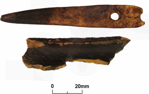
The drilled bone fragment was subject to radiocarbon dating giving a date of 1995 ± 26 BP (uncalibrated), 46 BC – AD 81 (Calibrated 92.2% at 2σ; Oxcal 4.4 & IntCal20) confirming a Roman age. The southern area of the Askrigg Bock is well known for a number of caves along the zone of the Craven Faults having produced archaeological finds including metalwork and bone of Romano-British age referred to as the Settle Caves (Lord and Howard Citation2013). These finds suggest the caves were used for a complex series of activities including the structured deposition of artefacts and both human and animal remains as well as for working bone and metal (Wilford Citation2019). Dowkerbottom Cave (SD95176890) on the south-western side of Littondale was the most easterly of these caves having been subject to excavation in the latter half of the nineteenth century and producing the remains of at least three humans along with pottery, animal bones and a range of Roman artefacts. Dowkerbottom Cave was considered to be used for domestic purposes by Branigan and Dearne (Citation1992) with an estimated date range of 55 BC to 375 AD, a time period which covers the radiocarbon date from Stonelands Cave being published here. The finds and radiocarbon date from Stonelands Cave confirm it was subject to human use during Roman times and possibly extends the geographical range of the artefactually rich Settle Caves across to the eastern flank of Littondale. The limited assemblage does suggest possible workshop occupation as defined by Branigan and Dearne (Citation1992) rather than domestic occupation which may have been limited by the occasional flooding due to the presence of an active stream at the site.
Please note
The cave is on private land and there is no public access to the cave or surrounding farmland.
Acknowledgements
The authors would like to thank Mr M. McKenzie for allowing access for this study. The radiocarbon dating was funded by the British Cave Research Association under their Cave Science and Technology Research Initiative funding programme.
Disclosure statement
No potential conflict of interest was reported by the authors.
Additional information
Funding
References
- Anon , 1960. “Stoneland Cave, Littondale.” Bradford Pothole Club Bulletin 3 (1): 21–22.
- Arthurton, R. S. , E. W. Johnson , and D. J. C. Mundy . 1988. “Geology of the Country around Settle.” Memoir of the British Geological Survey, Sheet 60 (England and Wales)
- Branigan, K. , and M. J. Dearne . 1991. A Gazetteer of Roman-British Cave Sites and Their Finds . Sheffield: Department of Archaeology and Prehistory, University of Sheffield.
- Branigan, K. , and M. J. Dearne . 1992. Romano-British Cavemen . Oxford: Oxbow Books, Oxbow Monograph 19.
- Brook, D. , G. M. Davies , M. H. Long , and P. F. Ryder . 1988. Northern Caves Volume 1, Wharfedale and the North-East . Clapham: Dalesman.
- Hall, A. and E. Hill , eds. 2015. Northern Sump Index . Wells: Cave Diving Group.
- Lord, T. , and J. Howard . 2013. “Cave Archaeology.” In Caves and Karst of the Yorkshire Dales , edited by T. Waltham and D. Lowe , vol. 1, Chapter 16. Buxton: British Cave Research Association.
- Long, H. 2017. “Caves of Wharfedale and Littondale.” In Caves and Karst of the Yorkshire Dales edited by T. Waltham and D. Lowe , vol. 2, Chapter 26. Buxton: British Cave Research Association.
- Murphy, P. J. , D. Hodgson , D. Richards , and D. C. Nita . 2019. “Stonelands Cave, Littondale, North Yorkshire, UK: evidence for Ice Caves in the Yorkshire Dales?” Cave and Karst Science 46 (3): 111–114.
- Murphy, P. J., D. Hodgson, D. Richards, and C. Standish. 2014. “Boreham Cave, Littondale, North Yorkshire – Some Geomorphological Observations.” Cave and Karst Science 40 (3): 109–113.
- Wilford, S. 2019. “Familiar Caves and Unfamiliar Landscapes: approaching Cave Use during the First Millennium in Britain.” In Between Worlds. Understanding Ritual Cave Use in Later Prehistory , edited by L. Buster , E. Warmenbol and D. Mlekuz : 67–85. Cham, Switzerland: Springer Nature.