
ABSTRACT
Walled sites attributed to the Xiongnu steppe empire (2nd century b.c.–1st century a.d.) constitute the earliest investments in explicitly non-mortuary built environments among pastoralists of the Mongolian Steppe. These permanent constructions are important precedents to the medieval towns of subsequent steppe empires, yet very little of the complete layouts and surrounding remains of the large enclosures are understood. Our investigations of the walled site at Kherlen-Bars in eastern Mongolia are among the first surveys to fully document all aspects above and below ground across an entire Iron Age walled site area. In addition to detailed documentation of the large structures, our geomagnetic prospections and digital elevation modeling brought to light numerous small sub-surface and subtle-surface features that show such early walled sites, often deemed virtually empty, to be far more complex and diachronic in their formation processes and possible functions.
Introduction
Comparative studies of ancient cities have made significant progress toward restructuring archaeological approaches to urban settings (Smith Citation2003, Citation2014; Cowgill Citation2004; Smith Citation2007, Citation2011; Marcus and Sabloff Citation2008; Creekmore and Fisher Citation2014; Yoffee Citation2015). Yet even though such urbanism studies have compelled us to break away from “procrustean typologies” (Smith Citation1989: 454) and work toward functional definitions of urban developments (Blanton Citation1976; Smith Citation2003; Cowgill Citation2004; Fletcher Citation2012; Johnson Citation2013), constructed centers among pastoral societies are rarely part of these collective conceptual dialogues and continue to receive cursory attention. As urbanization in ancient societies has been conceptually linked to the growth of agrarian surplus (Childe Citation1950; Fletcher Citation1995; Yoffee Citation2005), so has the development of permanent centers of social, economic, and ritual activities been erroneously deemed incompatible with pastoral economies and mobile lifeways (Porter Citation2004; Durand-Guédy Citation2013; Honeychurch and Makarewicz Citation2016). Permanent settlements established by mobile pastoral groups thus present a challenge to prevailing models of urban settings and their associated landscapes. They compel us to redress and expand overarching models of urbanism beyond the cities of classic agrarian civilizations.
Scholarship on urban centers in Inner Asia has highlighted the importance of massive medieval towns in steppe societies of the Uighur, Khitan, and Mongol regimes (Rogers et al. Citation2005; Honeychurch and Amartüvshin Citation2007; Bemmann et al. Citation2011). However, the earliest walled establishments of Inner Asia, which appeared in the Xiongnu empire (Waugh Citation2010), have only recently been investigated with the same degree of intensity as the later constructions (National Museum of Korea et al. Citation2017; Kradin et al. Citation2016, Citation2017). These sites are recognized for their walls and mounded architecture but, amid a shortage of studies beyond the more monumental features and a dearth of evidence for human activities beyond construction, substantial evidence for their functions or formation processes has not yet come to light. We thus initiated full scale investigations of the largest Iron Age walled enclosure—Kherlen-Bars 2 in eastern Mongolia—in order to elucidate the full range of features and activities that occurred at these earliest of enclosed built environments. Only with a more comprehensive understanding of the remains of these sites and their surroundings may we discuss their roles in the Xiongnu steppe polity and the ways in which they laid the foundations for the later urban establishments.
Xiongnu Habitations
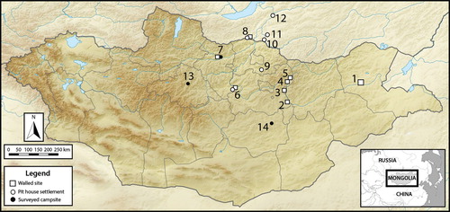
Numerous mortuary sites across Inner Asia attest to the broad expanse of the Xiongnu steppe empire (2nd century b.c.–1st century a.d.), yet corresponding habitation sites remain seldom documented or investigated (Waugh Citation2010; Brosseder and Miller Citation2011) (). Recent field work in Mongolia has sought to better account for mobile pastoral communities of the Xiongnu by answering the challenge of locating ephemeral “camp sites” in the steppe (Wright et al. Citation2009; Amartüvshin and Honeychurch Citation2010; Houle and Broderick Citation2011; Simukhin Citation2011; Galdan Citation2015; Gardner and Burentogtokh Citation2018). These have been identified primarily through surface findings of sherd scatters, but include shovel probes that have unearthed abundant fragments of pottery, animal bones, and iron slag as well as some remnants of pits and hearths. The presence of charred wheat (Tritucum sp.) and barley (Hordeum sp.) grains at some camp sites (Wright et al. Citation2009) at least indicate exchange with agricultural communities, echoed by isotopic studies of human remains that evidence increased consumption of millet during the Xiongnu era (Ventresca Miller and Makarewicz Citationin press). The assemblages of ephemeral habitations thus far do not include any tools of production, but the presence of iron slag clearly attests to craft production at such habitations as well as an engagement with iron working outside of large workshops (Houle and Broderick Citation2011; Sasada and Amartüvshin Citation2014; Ishtseren et al. Citation2015; Amartüvshin and Murakami Citation2018).
Figure 1. Xiongnu habitation sites (white markers indicate permanent settlements; black markers indicate ephemeral habitation findings): 1) Kherlen-Bars; 2) Gua Dov; 3) Gün-Galuu; 4) Bürkh; 5) Terelj; 6) Zaan-khoshuu; 7) Kholtostyn-Khürem (Egiin Gol); 8) Bayan-Under; 9) Boroo; 10) Dureny; 11) Nijnii-Mangirtui; 12) Ivolga; 13) Khanui Gol; and 14) Baga Gazaryn Chuluu.
Ancient Chinese chroniclers often present a normative narrative of the Xiongnu as wholly unsettled, “without walled cities or constant places [of residence] or endeavors of tilling fields” (Sima Qian Citation1959: 2879); however, historical records and archaeological remains within the steppe intimate a variety of lifeways, including agricultural engagements and permanent settlements (T’ang Citation1981; Hayashi Citation1984; Di Cosmo Citation1994). Several habitation sites consisting of numerous semi-subterranean houses and refuse pits have been found across the grassland and forest-steppe (Davydova Citation1995; Davydova and Miniaev Citation2003; Pousaz et al. Citation2013; Nei Menggu and International Institute Citation2015b; Konovalov et al. Citation2016; Kradin et al. Citation2016; Miyagashev et al. Citation2017). The houses included post holes for an aboveground roofed structure as well as corner hearths connected to heating flues paved with stones that wrap around the edges of the structures. The predominant assemblage of livestock remains indicate pastoral engagements—sheep and goat, cattle, and horse—and are supplemented at some pit-house sites by dog, pig (boar?), fox, deer, marmot bird, and fish bones as well as millet and some wheat or barley grains (Davydova Citation1995: 43–57; Pousaz et al. Citation2013: 198–209). In addition to a large assortment of ceramic vessel fragments, from large pots to small bowls, these sites have yielded a variety of bone leather-working tools, personal ornamentation, ceramic wasters, iron ploughs and hoes, and iron slag. Craft production at both campsites and pit-house settlements was likely connected to production systems that incorporated even larger workshops, such as Khustyn-Bulag near the walled sites of Terelj and Bürkh, where archaeologists have uncovered ceramic firing kilns and tuyere-bearing iron smelting furnaces (National Museum of Korea et al. Citation2001; Amartüvshin and Murakami Citation2018). These permanent settlements, at which a variety of craft production and subsistence activities occurred, clearly overturn the inherited normative narratives of a purely nomadic society with no permanent structures or settled habitations.
In relation to both ephemeral camps and pit-house settlements, however, the handful of monumental enclosures of the Xiongnu, with their prominent walls and platforms, indicate investments in constructed centers of activity greater than portable campsite tents or low semi-subterranean houses. But despite scholarly recognition of their rarity and importance in Xiongnu society, a mere fraction of these sites have been studied, unearthing only the portions of the conspicuous surface features and leaving the assumed empty areas and remains below the surface unexplored (Perlee Citation2012 [Citation1957]; Danilov Citation2004, Citation2009). These limited assessments and their findings have so far left us with only typological conjectures—from fortified garrisons to elite palaces to ritual temples (Perlee Citation1961; Hayashi Citation1984; Törbat and Gantogtokh Citation2010; Danilov Citation2011; Pousaz et al. Citation2013)—as to their probable functions in Xiongnu society. Our investigations of Kherlen-Bars 2 aim therefore to augment knowledge of the assortment of features and remains at such sites and allow for a richer understanding of the formations and functions of these monumental enclosures as well as their associated surroundings.
Prospections of Kherlen-Bars 2 Walled Site
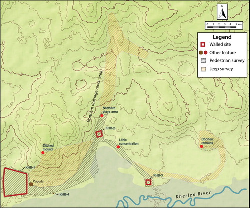
The Kherlen-Bars locale lies beside the Kherlen River in the grasslands of eastern Mongolia and consists of three walled enclosures a few kilometers from one another (). Exploratory surveys by Mongolian archaeologists in the 1950s concluded that these were constructs of the Xiongnu, Khitan (10th–12th century a.d.), and Mongol (13th–15th century a.d.) empires (Perlee Citation2012 [Citation1957]). The recurrence of monumental built environments during varied eras of nomadic regimes denotes the significance of this locale for the convergence of social, ritual, political, and/or economic institutions. As such, the area serves as an ideal case for investigating constructed centers with permanent architecture and how urban settings emerged and developed among mobile pastoral groups of the Inner Asian steppe. Current fieldwork focuses on the earliest of the three structures, Kherlen-Bars 2 (KHB-2, also known as Bars-Khot II), in order to elucidate incipient forms of built environments in the steppe.
Figure 2. Kherlen-Bars area map showing the locations of four sites: KHB-1 (Khitan); KHB-2 (Xiongnu); KHB-3 (Mongol); KHB-4 (indeterminate).
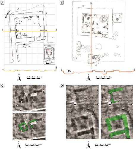
The first investigations of KHB-2 sought to clarify those features that were plainly visible in the open grassland (Perlee Citation2012 [Citation1957]: 178–180). A rough sketch was made of the walled site that estimated its enclosure as 345 × 335 m in area with 4–5 m wide walls and plotted the inner features of one small and two large mounds, as well as suggested the location of gateway openings in the north and south walls (). The enclosure is oriented along a NW-SE slope, which stretches down towards the alluvial plain of the Kherlen River. This location means that the mounds in northern portion had been set on the most prominent topographical position, providing the best view towards the river valley to the south.
Figure 3. KHB-2 sketch map showing the location of Perlee excavations (in gray dark). Features shown include: 1) the enclosure wall; 2) the East mound; 3) the West mound; and 4) the Small west mound. Redrawn from Perlee (Citation2012 [Citation1957]: 178).
![Figure 3. KHB-2 sketch map showing the location of Perlee excavations (in gray dark). Features shown include: 1) the enclosure wall; 2) the East mound; 3) the West mound; and 4) the Small west mound. Redrawn from Perlee (Citation2012 [Citation1957]: 178).](/cms/asset/56e35a1c-dde0-4f68-89f0-103c9c3958e0/yjfa_a_1598170_f0003_ob.jpg)
Virtually no debris was found within the enclosure or atop the surface of the mounds, and earlier exploratory excavations made on the two larger mounds recovered minimal artifacts. The northern half of the top of the eastern mound (: 2) was cleared 10 cm down to the original surface, revealing scattered debris of burned and decayed wood. Excavations at the surface of the western mound (: 3) unearthed residues of fire-related human activity atop the mound (Perlee Citation2012 [Citation1957]: 178).
The western mound was investigated further by cutting two long probing trenches north-south (10 m) and east-west (20 m) through the mound structure. These trenches are noted as having revealed layered foundations of thick tamped earth equivalent to mound construction methods at the Xiongnu walled sites of Terelj and Bürkh (Perlee Citation2012 [Citation1957]: 178). Although no specifics of the long east-west trench are given in the text or drawings of the report, the sketch of the north-south trench illustrates varied construction methods (). While the mound was clearly built up with alternating layers of tamped earth, the two walls of this trench reveal a duality of mound construction. Different frequency, make-up, and thickness of earthen layers are shown in the eastern and western walls of the trench, and these distinct construction methods are seen abutting one another in the northern wall profile. This disparity in construction is given no discussion or possible explanation in the original report, though results from our magnetic prospection (discussed below) provide some complementary data that may help explain such horizontal alterations in the mound structure. On top of the mound are the remnants of an additional smaller earthen construction with an apparent third manner of construction with interspersed layers of brown earth with white splotches (Perlee Citation2012 [Citation1957]: 180).
Figure 4. KHB-2 West mound north-south cross section. Redrawn from Perlee (Citation2012 [Citation1957]: 180).
![Figure 4. KHB-2 West mound north-south cross section. Redrawn from Perlee (Citation2012 [Citation1957]: 180).](/cms/asset/edf094dc-de94-4936-8030-b68057f05872/yjfa_a_1598170_f0004_oc.jpg)
At 1.25 m deep within the eastern edge of the mound, the excavators discovered the broken remains of a large ceramic pot—measuring 71 cm tall, 41 cm broad, and 21 cm wide at the foot—with broad shoulders and a narrow mouth that generally resembles storage jars of the Xiongnu era. Broad shoulder and narrow mouth jars were produced in many of the later eras, and the exact lip and neck forms can vary greatly even among pottery of sites securely dated to the Xiongnu era. However, it was the shoulder wave-line decoration and stamped horn-sign mark on the underside of the vessel bottom, both aspects particular to Xiongnu era pottery (see, for example, Eregzen [Citation2016]), that led Perlee (Citation2012 [Citation1957]: 178–179) to equate the vessel to a Xiongnu era pot and thus preliminarily attribute the site to the Xiongnu era. Although the drawing in the published report is vague at best (Perlee Citation2012 [Citation1957]: 189), there are no mentions of punctate decorations characteristic of Khitan era pottery that would indicate the vessel dating to the Khitan period (Erdenebold and Törbat Citation2016).
Ample ceramic and wooden architectural remains at the other two walled sites of Kherlen Bars, including a plethora of diagnostic vessel and architectural ceramics, allow for fairly confident dating to the medieval Khitan (KHB-1) and Mongol (KHB-3) eras (Perlee Citation2012 [Citation1957]: 157–177). However, the singular pot within the mound at KHB-2, now no longer available for analysis, and a relative dearth of any other diagnostic materials recovered on the surface or through excavation at KHB-2 have, until now, left the dating of this site as tenuously attributable to the Xiongnu era but in need of further investigation and materials more securely indicative of Xiongnu era occupation (Perlee Citation1961: 34).
In order to test and possibly improve upon Perlee’s initial work, we aimed to examine any other remains or features that could be associated with Xiongnu era activity. Our preliminary survey work in 2015 hence sought to recheck surface remains within and outside of the walls; obtain more detailed surface mapping of the site, including the detection of any previously unknown more subtle features; prospect for any yet-unknown subsurface features; and explore any newly discovered features to better document them. During eight days of fieldwork, we gathered data that sufficiently demonstrate a greater spatial and temporal complexity of the KHB-2 enclosure than previously presumed.
Surface Collection
The low density of surface scatter at the walled site, noted both by Perlee (Citation2012 [Citation1957]) and by our team upon initial inspection, demanded a more intensive and structured surface collection strategy of 10 m slow walking intervals both within the enclosure and in two 1 ha units outside the enclosure, located to the west and west-southwest. These additional areas provided a non-enclosure background distributions of artifacts to which the interior collections were compared. The initial impression of a low density scatter was borne out by the collection, yielding little to no ceramic vessel sherds on the surface.
The dominant category of finds recovered by this surface survey of the walled site was chipped stone artifacts and debitage, followed by sherds dating to the Khitan era (). The substantial presence of prehistoric used tools at this locale suggests long term use of the site, perhaps valued for its expedient drainage and access to the Kherlen River and its wetlands. The same reliable water access, as well as additional walls for shelter, may have drawn later inhabitants to the place, demonstrated by the greater number of, though still few, Khitan period finer gray-ware sherds, sometimes with characteristic punctate decoration, found on the surface. One possible Xiongnu coarse gray-ware sherd was found within the enclosure in the northwest quadrant, and only one definitive Xiongnu coarse gray-ware sherd, with diagnostic paddle and anvil construction and scrape-polish decoration, was found in the west-southwest exterior unit at KHB-2 ().
Figure 5. Xiongnu grey-ware sherd with white temper and scrape-polish decoration, from southwest exterior surface collection unit.
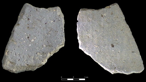
Table 1. Historical era findings of surface survey.
Similar enclosures in central Mongolia yield numerous ceramic tiles on the surface and a plethora of roof and floor tiles unearthed from excavation, the form of which unequivocally relate them to the Xiongnu era (: sites 2–5) (Perlee Citation1961; Danilov Citation2004, Citation2009; National Museum of Korea et al. Citation2017). In stark contrast to the ample tile fragments at these sites, as well as at the nearby enclosures of KHB-1 and KHB-3, no architectural components were found on the surface at KHB-2, or in the process of test excavations. However, regardless of ceramic architectural pieces attributable to the Xiongnu era, the interiors of the other equivalent enclosures are also virtually devoid of ceramic vessel sherds.
In addition to the two Xiongnu sherds found in the close pedestrian surveys of KHB-2 () and two other possible Xiongnu gray-ware sherds found in the more extensive pedestrian surveys, the only noteworthy collection of Xiongnu sherds in the vicinity of KHB-2 was found in a playa area of drainage approximately 1 km north of the enclosure, an area which also yielded a large collection of Khitan period sherds (). This playa area is an important representation of habitation outside of the KHB-2 walled site, and was apparently occupied in equal fashion during the Xiongnu and later Khitan era. The discrepancy between sherd equivalence at the playa area on one hand, and sherd inequality within the KHB-2 enclosure on the other, highlights a style of Xiongnu era occupation for KHB-2 that differs significantly from habitation sites outside of the walls. Furthermore, the relative dearth of vessel sherds and other domestic debitage between the prehistoric and Khitan eras within the walls would indicate something other than normal habitation for the Xiongnu phase.
Magnetic Survey
In order to investigate the structure of the known walls and mounds as well as to assess the presence of other features within the enclosure and in its immediate surroundings, we conducted a magnetic survey of 30.3 ha. We used a setup of an 8-channel magnetometer (SENSYS MAGNETO®-MX ARCH), which was mounted on a fiberglass carriage pushed by two people at once. The 8 gradiometers were set in 0.5 m intervals, spanning a 4 m wide measurement frame. Measurements were geo-referenced by a differential-GPS system (LEICA), installed on the carriage. We covered the enclosure interior and its walls as well as a 50–60 m span outside the walls (22.3 ha in total) by following north-south oriented transect walks. We also sampled the wider surrounding of the walled site with additional 5 transects per side that reached outward approximately 250 m in each direction (8 ha of additional survey, encompassing a total area of 66.5 ha).
The magnetic map visualizes several categories of information at the site (). Firstly, the area was scattered with modern metallic debris from on-site vehicle repairing, most of which we removed before walking the successive transects but some smaller obscure pieces of which remained. These show up in the plan as a fast succession of dipoles. Another level not associated with archaeological features is the dense pattern of lines, roughly running from northwest to southeast, following the elevation of the area. In some places, especially in the south, there is a net-like structure. These lines and net-like patterns are most likely caused by geological processes. A third level of non-archaeological information visible in the magnetic survey results consists of several modern roads that follow alongside or cut through the structure from east to west. Lastly, there are a number of anomalies that we designate as archaeological features. These can be grouped into two categories: remnants of architecture, most of which are visible on the surface, and remnants of subsurface pits and trenches. The architecture is most prominently represented by the main enclosure wall and several mounds in the interior.
Figure 6. A) The KHB-2 magnetics prospection map and B) details from that map including: 1) the enclosure wall; 2) the East mound; 3) the West mound; 4) the Small west mound; 5) the Northwest platform (KHB-201); 6–7) Northeast structures; 8–10) round pits (including KHB-202); and 11–23) shallow trenches (including KHB-203).
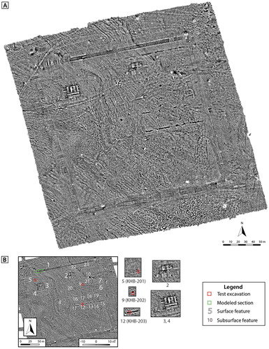
The surrounding walls (: 1) are clearly visible on the surface, currently standing approximately 2 m high, and form a slightly irregular square—with the western wall being 347 m long, the northern 355 m, the eastern 342 m, and the southern 349 m—around a 10.9 ha enclosed space. The magnetic plan indicates that these walls originally had a straight and regular shape, 8–9 m wide, but also that most portions of the walls are formed from individual sections with different sizes and degrees of preservation. The northern wall is the most clearly bounded anomaly; a straight 7.7 m wide construction of material with positive magnetization, in contrast to its surroundings. It is bordered on each side by a 1.3 m wide negative magnetic signal, which can be interpreted as a dipole effect. This magnetically clear northern section of the wall runs from the northeastern corner for 268 m to the west, where it seems to form one uniform architectural feature. However, the magnetic plan reveals more than one building pattern.
The other portions of the walls appear sufficiently defined in the magnetic plan to delineate their structure, yet not as uniform or clear-cut as the main northern portion. They seem to spread out a bit more on the edges, as is most evident in sections of the eastern and southern walls. To the west of the uniform northern wall section, the body of the wall is made up of 24 relatively thin square or rectangular sections, which have very different magnetic signals, reaching from high positive to high negative values, often directly beside one another. These value differences do not reflect the aforementioned dipole effects, which are also visible on either sides of the collective wall body, but rather relate to different earthen components of wall sections. These have differing lengths as well, from 8 m square segments to thinner ones of 2–4 m. The adjacent northwestern corner is constructed by several trapezoidal segments that create a somewhat curved and acute angle.
The western wall continues in a segmented mode of construction with varying lengths. A few segments are as long as 22 or 38 m, though most measure between 4 and 8 m. One of these longer segments, in the southern part of the western wall, resembles the uniform northern segments with a dipole effect frame 1.4 m wide on either side; in this case, however, with a positive magnetic signal that intimates a different building material. The southeastern corner shows a slightly different construction technique than the northwestern one. Here, the corner is formed by two complementary right triangles to form an almost perfect intersecting angle. The same dual triangular construction is used to form the northeastern corner, but the south-eastern one is, as already mentioned, not well enough preserved to determine.
The magnetic survey also elucidated the construction methods of the previously identified structures (: 2–4) as well as for three newly discovered structures (: 5–7). For the three structures already investigated by Perlee (Citation2012 [Citation1957]: 178) (), the same segmental technique as the enclosure walls was used to build the rectangular mounds. The eastern mound (: 2) is shown to be a large structure, measuring 44.0 × 26.5 m, built from over a dozen distinct segments in alternating signal patterns resembling those of the wall sections. A striking feature 2.5 m in diameter is apparent in the middle of one of these segments, though its interpretation is difficult since it lies within the portion excavated by Perlee.
The western mound (: 3) measured 33.6 × 24.5 m and was also built with similar segments. The sectioning construction of this mound is much clearer on the magnetic plan, as is the location of the two Perlee test excavations indicated by the bright white (negative) signals extending north-south and east-west (). The magnetic plan shows the north-south trench as lying exactly at the intersection of two distinct segments. Perlee’s test trench is thus not only given greater context by the magnetic survey, it also provides insight into the horizontal difference in segments seen in the magnetic plan as well as the different vertical interior layering of each segment (). The two segments exposed in Perlee’s trench have similar techniques but the eastern and western trench walls show differences in the numbers, thicknesses, and types of vertical layers for the respective segments. The north trench wall additionally shows the manner in which two segments adjoin.
The smaller feature (: 4) adjacent to the large western mound is less clear, though the black section lines visible on the magnetic plan may in fact indicate two very small adjacent square structures, approximately 5 m wide, that lie beneath the remnant earthen pile. Perlee (Citation2012 [Citation1957]: 178) noted a test excavation of this feature on his sketch map, and the remnants of that test can still be seen (), but no description is given for that excavation. The magnetic image of this one (or possibly two) small structure resembles the square frame formations of the two newly discovered structures along the eastern wall (: 6–7), though of rougher configurations. The larger of these square frames (6) measures approximately 14 × 13 m, with wall sections over 2 m wide, while the smaller, and less distinct, structure to the north (7) measures 9.5 m. In contrast to the larger mounds (: 2–3), these two features are virtually invisible on the surface.
Figure 7. Comparative rectangular structures: A) Northwest house at Bayan-Under (Danilov Citation2011); B) House 9 and pit-houses 10 and 15 at Ivolga (Davydova Citation1995: fig. 24); C) small structures beneath feature 4 at KHB-2; and D) large structures 6 and 7 at KHB-2.
To the north of the western features (: 3–4), magnetic survey enabled us to identify another faintly visible square anomaly (: 5) measuring 22.8 × ∼18 m. The northern edge of this feature is not clearly defined, probably because it is partly covered by remnants of the adjacent wall, a circumstance noted in Perlee’s original site sketch as a seeming bulbous protrusion on the interior edge of the northern wall (). Unlike the other segmented or framed features, this structure is one continuous signal. We excavated a test trench (KHB-201) at the southeast corner to assess the nature of this feature responsible for the uniform magnetic signal and discovered a platform set on top of a ground-level foundation (see below).
Another category of features revealed by the magnetic survey are the circular and linear anomalies of high positive nT values. The circular features, measuring approximately 4.5 m wide, occur one in the center of the enclosure (: 8) and two in the northeast quadrant (: 9–10). Also in the northeast quadrant, were found a series of east-west oriented lines ca. 2.5 m wide (: 11–23), arranged from north to south in rows approximately 30–40 m apart. Some lines are only a few meters long whereas others extend as much as 28.5 m. We tested both these types of anomalies by excavating one half of the circular features (: 9; KHB-202) and a cross section of one of the lines (: 12; KHB-203). These excavations, discussed below, respectively revealed a deep pit and a shallow trench.
Digital Elevation Modeling
Along with magnetic surveying, our transect walks simultaneously employed a differential GPS device attached to the carriage for the creation of a digital elevation model (DEM) of the enclosure and its associated surface features, many of which were not visible either standing on site or in the magnetic plan. The resulting DEM elucidated additional walls (: 24–25) as well as several small round features (: 26–32). The two additional low walls, virtually invisible to the naked eye, measure 197 m (24) and 147 m (25). When abutted with the northeast portion of the much higher main walls, these lower walls form a rectangular interior enclosure and perfectly envelope the series of previously mentioned east-west oriented ditches (: 11–23), helping to explain the restriction of the ditches to the northeast quadrant and indicating a direct association between the two sets of features.
Figure 8. A) KHB-2 Digital Elevation Model showing: 1) the enclosure wall; 2) the East mound; 3) the West mound; 4) the Small west mound; 5) the Northwest platform; 6–7) Northeast structures; 24–25) the low wall; 26) the Central low mound; and 27–32) Southern low mounds. B) A subset of the northeastern corner of the KHB-3 DEM highlighting the low features.
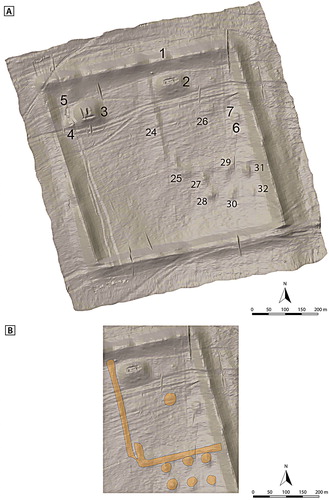
The round features are smaller and far lower than the large mounds, measuring approximately 20 m wide. The lone round feature (: 26) sits directly in the center of the interior enclosure, and the six other mounds (: 27–32), in two rows of three, are placed so close to and parallel with the southern edge of the enclosure that they are most likely associated. The second reason to deduce such an association is the equivalency of earthen construction; namely the apparent lack of hard-tamped and segmented construction used for the other features (: 1–7) that rendered them invisible on the magnetic plan. It is difficult to say whether these two categories of earthen constructions, one clearly visible in the magnetic plan and the other not at all, denote merely varied techniques of contemporaneous features or relate to two distinct eras of construction and occupation. Without firm dates of their respective materials, we cannot yet determine a difference in age.
Test Excavations
In order to test some of our initial interpretations of the magnetic plans we obtained in the field, as well as to procure datable material, we conducted three small-scale excavations during our short expedition (). The first test (KHB-201) opened a 3 × 1 m pit at the edge of the large northwestern square feature (: 4) in order to identify the structure causing the magnetic anomaly (). The profile of the western trench wall shows both the structure (in the northern portion of the test pit) and the adjacent area (the southern third of the test pit) beside the detected anomaly. The area adjacent to the feature exhibits two distinct and sharply defined layers. The upper layer (KHB- 201/1) is 60 cm thick and a light-brown (10 YR 7/3) extremely compact sand-grit mixture, and continues across the entire test pit, overtop the layers of the archaeological feature. The lower layer (KHB-201/2) is a medium brown (10 YR 5/13) homogeneous sand-silt mixture, except for a few frost-cracks and bioturbation, and relates to the underlying layer of sterile soil. The contact between these two layers is almost perfectly smooth, intimating the original surface of this area of the enclosure had been level.
Figure 9. KHB-201 test pit profile section.
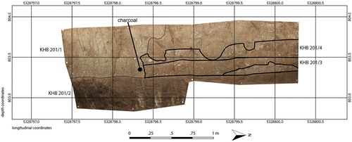
The northern portion of the test trench exposed a two-layered feature placed directly on top of the surface of the lower level (KHB-201/2). The bottom layer of this feature (KHB-201/3) consists of a regular-formed compact sand-gravel-mixture 10–15 cm thick, and ends abruptly at the southern edge. The second layer (KHB-201/4), which is partly disturbed by bioturbation, is of almost the same composition. As large animal holes have pushed through its southern end, it is not clear whether KHB-201/4 ended directly at the same point as KHB-201/3, or whether the upper layer would have been tapered from the lower layer to create a step from one layer to the next. These two sections, though of seemingly equivalent composition, are well-delineated by a thin concentration of white grit that lines the edges of each layer. The fine gravel, which produced the distinct magnetic signal, characterizes both layers (KHB-201/3,4), which were constructed over the artificially leveled surface of KHB-201/2.
The final layer (KHB-201/1) thus represents a colluvial deposit, perhaps coming down from the wall to the north and accumulating over top of the platform. Small charcoal fragments found in the sediment of KHB-201/1 just beside KHB-201/3 () yielded very early dates of 3160 ± 35 b.c. (). This may be the result of dating charcoal from very old wood or, more likely, of sampling remains outside of the KHB-201/3,4 construction layers that could be from remains of previous activities not directly related to the platform structure.
Table 2. Radiocarbon dates calibrated using OxCal v4.2.3 Bronk Ramsey and Lee (Citation2013) and IntCal13 atmospheric curve (Reimer et al. Citation2013).
Test trench KHB-202 was dug into the southern half of one of the circular anomalies (: 9), interpreted as pits, in order to assess its exact form and possible contents (). We began with a 1 × 4 m trench, which we subsequently widened to a 2 × 6 m trench. We found one feature (KHB-202/1) with a steep southern edge, consisting of a homogenous dark-brown fill, 7.5 YR 2/3, which we could follow to a depth of 1.9 m, when it left the confines of our trench, making further work unfeasible in the deepest northern corner. At this point, however, we had not yet reached the center of the 4.5 m wide anomaly. This pit did not yield a single cultural object or other obvious remains of anthropogenic activity, except that the entire pit was filled in with a singular layer (KHB-202/1) likely as a result of purposeful infill.
Figure 10. KHB-202 test pit profile section.
Due to its steep sloping edge and great depth, which potentially continues for at least a meter further below the assessed depth, this feature may very well have been a water well. KHB-2 walled enclosure sits on a prominent drainage area down toward the Kherlen river basin, and at least one modern water well (currently abandoned) was found several meters east of the enclosure. Similar deep pits have been found at Ivolga pit-house settlement; these also exhibit singular events of purposeful infill and reach underground water table at 4.5 m deep (Davydova Citation1995: 75). Although both the modern water well adjacent to KHB-2 and the ancient pits at Ivolga are of narrower proportions (the latter measuring over 2 m wide at the mouth and tapered to a 1.2 m wide shaft), the two large round pits documented in the magnetometry survey at KHB-2 (: 8–9) may still be the vestiges of water wells. Yet, as Ivolga was clearly a habitation site with ample remains, KHB-2 thus far yields minimal habitation remains and thereby questioning the presence of a water well. Furthermore, if it had been a storage pit, it was cleaned out and not left with refuse in the process of filling as the pits at Xiongnu pit-house settlements were (Davydova Citation1995; Davydova and Miniaev Citation2003; Pousaz et al. Citation2013; Nei Menggu and International Institute Citation2015a). Continued and more complete excavations, as well as detailed soils analyses and dating material, will be conducted to further explore this theory and the function of these large pits.
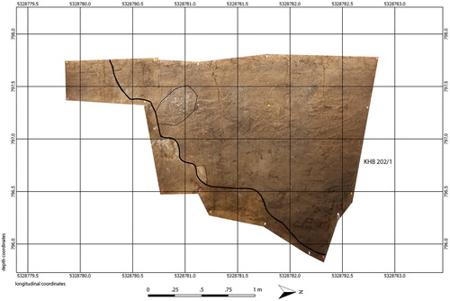
One of the linear features (: 12) at the southern edge of the interior low-wall enclosure was investigated with a 2 × 1 m test trench KHB-203 (). This revealed a trench 90 cm deep, with a bottom about 70 cm wide and sides, when not disturbed by bioturbation, forming a gentle curving slope. Five distinct layers occurred within the trench, as well as several signs of bioturbation (KHB-203/5, 6, 7). The heterogeneity of the filling indicates a complicated history, showing both phases of steady sedimentation as well as more sudden infill. At the bottom of the feature was a layer of natural greenish clay (KHB-203/1). Above this was a layer of homogenous, dark grey sediment (KHB-203/2; 7.5 YR 24/1), followed by a light grey sediment (KHB-203/3; 10 YR 7/1), and then a dark grey-brownish layer on top (KHB-203/4; 7.5 YR 3/2). Save for the few faunal fragments recovered, there was an almost complete absence of artifacts, and this feature was thus not used as for refuse in the way that trenches at other settlements were densely infilled with debris (Davydova Citation1995: 74–75; Wright, Honeychurch, and Amartüvshin Citation2009: 381). From this test excavation we infer the line anomalies (: 11–23) to be long, shallow trenches of as yet unknown function, in which we can identify four successive filling layers.
Figure 11. KHB-203 test pit profile section.
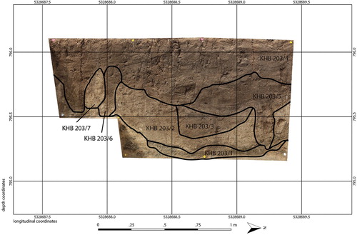
The thin first layer of infill (KHB-203/1) we associate with dirt and debris from the initial disuse of the original trench. This layer at the bottom of the trench contained two sheep/goat bone fragments and one gazelle bone fragment that yielded dates between a.d. 120–170 ± 30 (), roughly contemporary with the collapse of the Xiongnu empire (i.e., 2nd century a.d.). These constitute the only faunal remains thus far discovered at KHB-2. The subsequent thicker layer (KHB-203/2), which appears to have filled in most of the original trench, likely relates to a recutting and subsequent refilling of the trench, with other thinner layers (KHB-203/3-7) as later intrusions into or fillings overtop the filled in trench. An event of purposeful refilling for the trench KHB-203 matches the evidence for a single infilling event documented for the pit KHB-202. This would suggest a construction of the trenches at some point before ca. a.d. 150, at which time they went into disuse and were later filled as part of construction for site reuse.
Magnetic modeling
In the course of our field expedition, we used the magnetic measurements from fluxgate gradiometers to produce a site plan of KHB-2 subsurface anomalies, and sought to clarify some of these features through test excavations. However, it is often also useful to perform non-invasive investigations of these features by modeling the anomalies, or, in other words, trying to find a model of the subsurface that explains the measured anomalies (Schneider et al. Citation2014). The problem with this procedure is that it is non-unique: the measured magnetic anomaly could be approximated by several different models.
If we assume only induced magnetization and no remnant magnetization, as we do in this study, the physical parameter measured to produce magnetic anomalies is the magnetic susceptibility of the sediment. If the magnetic susceptibility of a subsurface body is different from its surroundings, a magnetic anomaly is measured. If the susceptibility contrast is high, the anomaly will be strong and vice versa. But another factor has to be taken into account when interpreting the strength of magnetic anomalies is the depth and geometry of the subsurface body. When the body is deeper, the magnetic anomaly will be weaker and wider compared to the anomaly of the same body that is shallower. Therefore, it is always helpful to constrain the modeling by a known quantity, either the geometry of features or the magnetic susceptibility.
The exact magnetic susceptibility of a subsurface body can be measured with susceptibility meters that have direct contact with the materials, such as in an excavation or in corings. On the other hand, if the geometry of the subsurface body is known (from excavation or through other means) the geometry can be taken as the known quantity and thus the magnetic susceptibility contrast can be derived. This was done in our study due to missing magnetic susceptibility measurements. We used the magnetic anomaly of the ditch in the eastern part of the enclosure (KHB-203) (), from which the geometry is known from excavation results (), as the known quantity. This geometry can therefore be used to derive the magnetic susceptibility contrast of the ditch by calculating the magnetic anomaly and fitting it to the measurements.
Figure 12. Comparison of measured and modeled magnetic anomalies. A) Shows the measured anomaly due to the ditch, with polygonal cross section shown in red; and B) shows how this measurement approximates the excavation results.
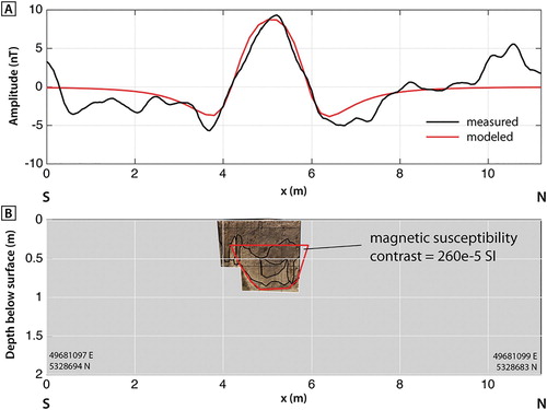
Modeling of the ditch was performed with code from Talwani (Citation1965) using a cross section of polygonal shape. Assuming a homogeneous susceptibility distribution throughout the ditch, it was found to be 260e-5 in SI units. The modeling only assumes induced magnetization and uses the parameter settings according to the measurements listed in . The measured and modeled curves () are very similar, but do not fit perfectly, which is due to smaller susceptibility variations in the subsurface not covered by the model, but for estimating magnetic susceptibility values it is sufficient. Because no directly measured magnetic susceptibility values are available, the derived magnetic susceptibility contrast for the filling of the ditch, which is humous soil, can be used as an approximate value also for other features in the study site that are composed of similar material.
Table 3. Settings used for magnetic modeling.
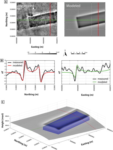
Using the estimated susceptibility contrast of humous soil to the surrounding soil, a section of the wall can be modelled by a prism underneath the currently visible form of the wall (). For modeling a prism, the code given by Blakely (Citation1996) is used with the same settings as for the ditch model. The fit between measured and modeled magnetic anomaly attains a 8.2 m wide and 30 m long prism, which is located about 0.6 m below the top of the wall and has a thickness of 0.7 m. One possibility is that the modeled prism reflects a frame filled with earth, which might have the same magnetic susceptibility as the filling of the ditch. Thus, the same susceptibility contrast was used. Again, the fit between measured and modeled anomaly is not perfect, but the small scale variations in the measured field are caused by susceptibility variations not covered by the simple model.
Figure 13. Comparison of measured and modelled magnetic anomalies. A) Shows the location of the cross-sections of the anomalies (the red and green lines), and B shows how the modeled data compares to the measured data for each. C) Shows a 3D model of the prism with the modeled magnetic anomaly on the topography.
Discussion
The combined use of a multi-channel magnetometer with a differential-GPS system (LEICA) provides a joint tool that significantly improves the ability to rapidly gather more precise and previously undetected information from large and seemingly empty archaeological sites like the KHB-2 enclosure. We argue here that this particular combination of subsurface (via magnetic signals) and detailed surface (via digital elevation model) documentation provides a more robust understanding of the site than any investigation that relies upon one of the methods alone. From a practical point of view, the necessary equipment was operated with a minimum of four people (two people per survey shift, our team being six), and achieved significant in-field results during a short period of time, in this case eight days. The combined surface and subsurface results, which were immediately available in the field rather than waiting on the processing of measurements, provided clear imaging of the shapes of subsurface anomalies and enabled us to decide upon and conduct additional trial excavations during the same expedition.
Subsurface prospection has also been conducted at other Xiongnu walled sites within the last few years (Kradin et al. Citation2016, Citation2017; Myung-jong, Jeong-ho et al. Citation2017). However, the results, constrained by the use of a singular gradiometer, have yielded imagery too coarse resolve smaller features like pits (: 8–10) or sectioning of walls and mounds (: sites 2, 5). Our survey therefore aimed to utilize multiple simultaneous gradiometers set at a small spacing of 0.5 m in order to produce a much clearer understanding of subsurface anomalies and even reveal features that would otherwise be not only greatly obscured but quite possibly muted.
With regard to the DEM we produced, it is important to point out that although elevation-modeled site maps based on satellite imagery usher in a vast improvement for accurate mapping of visible surface features as compared with decades old site sketches, these often lack the detailed data necessary to detect extremely subtle yet important features such as the remnant low walls and mounds of KHB-2 (: 24–32). Although these rise only several centimeters above the surface, they were revealed by the DEM produced by this survey. While this DEM does not possess the precision over large areas that can be produced using LIDAR data (Hüttel and Erdenebat Citation2009; Evans et al. Citation2013), DEM surface maps based on DGPS data are produced at a vastly lower cost. One of the practical goals of our combined gradiometer and DGPS survey was thus to achieve a balance between obtaining an enhanced and finer-grain picture of the full spectrum of features at the site without incurring excessive costs.
Magnetic prospection of the more prominent walls (: 1) and mounds (: 2–3) at the site suggest building techniques more complex than a mere uniform construction of compacted earth. As described above, Perlee’s preliminary test excavations cross-cutting the western mound (: 3, ) were the first to shed light on the complex layering and sectioning of these constructions. The distinct and varied signals of the magnetic data, oscillating between high and low, suggests a planned use of alternating layered sections of compacted earth to erect the two large mounds. The main enclosure, however, shows more irregular sectioning for different portions of the walls. While the north wall appears of uniform construction material, the west and south walls employ an alternate sectioning technique similar to the main mounds, and the northwest corner appears to be a tight series of earthen slivers. A possible explanation for this variability could be an involvement of different construction teams or different construction events, each with different techniques. Whether this relates to the collaboration of independent teams, seasonal or annual phases of construction (or occupation), subsequent events of wall repair, or the sourcing of different earth as construction proceeded remains to be seen. In any case, these monumental constructions required concerted collaborations (Wright Citation2017). They enlarged the frame concept exhibited in the inner earthen walls and employed a different technology of hard-tamped earth, a technique that provides clear signals and an obvious footprint in the magnetic survey map (: 24–32).
Our combined fine-tuned subsurface magnetic and surface elevation surveys demonstrate two categories of construction: the larger prominent compacted earth features and the lesser ones within the northeast quadrant. Although these different categories of features indicate a complex succession of building activities and very likely relate to different eras of construction and occupation, more dates of the various features are needed to assess the duration of occupation as well as the chronological timing and sequence of building activities. The radiocarbon dated bones from test trench KHB-203 confirm that these trenches were open, and likely in use, at least during the late 1st to early 2nd centuries a.d., when the bones entered the trench before they were filled in. This suggests site use during the late Xiongnu era as well as subsequent transformation of the site after that time ().
Many of the previously assumed Xiongnu walled sites have rightfully been called into question (Perlee Citation1961), and many of them, when tested, have failed to produce definitively Xiongnu era material or dates (Purcell and Spurr Citation2006; Eregzen Citation2017a). Leaving aside the questionably early date (ca. 4000 b.c.) of the charcoal sample beside the ground-level platform (: 5) from test excavation KHB-201, the three bone dates from within the trench at KHB-203 date more or less to the latest end of the Xiongnu era. These most likely correspond to the first infilling event of the long ditch (: 12), during a time when the Xiongnu empire was disintegrating (early 2nd century a.d.) and the relatively prominent walled sites of the empire in central Mongolia, built with Chinese-inspired architecture of walls and roofs, appear to have gone into disuse (Eregzen Citation2017b). Perlee’s finding of a Xiongnu style ceramic vessel within the western mound (: 3), together with our radiocarbon dates, make the case for a Xiongnu phase of occupation at KHB-2 stronger.
Many of the features discovered at KHB-2 have parallels at other confirmed Xiongnu sites. The large mounds with remnants of prepared floors and wooden construction overtop (: 2–3) represent structures immensely different from ground-level tents and pit-houses, even if they do not have the added embellishments of pebbled pathways, roof tiles, and columns with stone bases found at Xiongnu walled sites in central Mongolia (Danilov Citation2009; Erdenebold et al. Citation2017; National Museum of Korea et al. Citation2017). The structures raised on top of mounds would have stood out in the landscape, even if surrounded by throng of tents. The ground-level platform with separate foundation and floor layers (: 5), a feature so far undocumented at the other Xiongnu walled sites, appears as a uniform structure in the geomagnetic plan. In the absence of any evidence for additional construction, it may have served as a location for conducting particular activities or for erecting a mobile structure. This lies in direct contrast to platforms with ample remains of walls and tiled roofs, and even column bases, for the erection of permanent structures found at Xiongnu walled sites elsewhere (National Museum of Korea et al. Citation2017). The over 20 m wide footprint of the platform suggests the designation of special place among the otherwise bare ground surface within the enclosure. In any case, it was part of an array of ground-level structures within the enclosure that would have complemented the larger mounded constructions.
Subsurface features at KHB-2 also find parallels at other Xiongnu walled sites. Along with the radiocarbon dates from feature KHB-203, these parallels contribute to an attribution of KHB-2 to the Xiongnu era, and may help clarify the functions of some of the newly discovered features. The round pits (: 8–10) resemble the dimensions of the occasional round pits (up to 4 m deep) at Ivolga pit-house settlement that are attributed to water wells (Davydova Citation1995: 75), though the exact function of the pits at KHB-2 have yet to be determined. Ditch-like pits of shape and dimensions similar to those in the northeast quadrant of KHB-2 have been found at along the outer walls of small enclosures and throughout the interiors of pit-house settlements. Unlike the long shallow ditches at Khitan and other medieval sites that are often lined with stones or ceramic tiles (Kradin et al. Citation2011), the trenches at Xiongnu sites are simple earthen ditches. However, unlike those at KHB-2, trenches at other Xiongnu sites usually contain a dense assortment of ceramic, faunal, and even botanical remains (Davydova Citation1995; Davydova and Miniaev Citation2003; Danilov and Zhavoronkova Citation1995; Wright et al. Citation2009: 381). This calls to attention both a similarity in construction techniques for trenches and pits as well as a lack of significant habitation remains within those equivalent features at KHB-2.
The double enclosure of Kholtostyn-Khürem (EGS 131), measuring 120 × 77 m and 90 × 90 m, had low walls surrounded by ditches (Törbat et al. Citation2003: 102–103). Test excavations of the ditches yielded significant infill, the remains of which were radiocarbon dated to the 1st century b.c.–3rd century a.d. (Wright et al. Citation2009: 381–382). In addition, a Chinese guiju-style bronze mirror fragment, typical of the 1st–2nd century a.d., was found within the northeast corner the enclosure further indicating a date of later Xiongnu era activity (William Honeychurch personal communication, 2018). But despite the findings of debris within the wall ditches, intensive shovel-test excavations across the entire enclosure have yielded scant remains of occupation within the walls (Bat-Erdene Citation2016). This site has thus been deemed neither a settlement nor a fortified enclave, but rather, may have served some manner of ritual function. Walled sites with interior mounds like KHB-2 may also have been a locus of ritual or other activity with their enclosed spaces and monumental structures that set them apart from the more open spaces of mobile pastoral enclaves in the steppe.
As stated above, this dearth of vessel fragments or other remains of habitation on the surface is characteristic as well of large rectangular walled sites of the Xiongnu found in central Mongolia (: sites 2–5). Walled sites attributed to the Xiongnu, such as Khermen Tal, which have yielded no refuse remains or diagnostic artifacts in the process of excavating the mounds and walls, continue to highlight the need for intensive remote and subsurface examinations (Purcell and Spurr Citation2006: 28–30; Nei Menggu and International Institute Citation2015a, Citation2015b). Although excavations at these other sites have confirmed a relative lack of habitation remains on the walls and mounds (Danilov Citation2009; Erdenebold et al. Citation2017; National Museum of Korea et al. Citation2017), there may still be places beneath the surface or further outside of the enclosures such as the northern playa area that have not been accounted for as part of the site locale and that may contain additional remains and refuse.
Ephemeral habitation sites in Egiin Gol valley demonstrate drastic differences between surface collected ceramics and subsurface yields from test excavations (: site 7) (Wright et al. Citation2009). The EGS 110 campsite, which measures 1.1 ha, has a ratio of recovered sherds of 5 surface to 900 subsurface finds, and the 1.2 ha EGS 486 campsite (radiocarbon dated to 1st century b.c.–1st century a.d.) yielded a ratio 7 to 816. The discrepancy in the case of the latter site may relate to the occurrence of a ditch-like trash pit, within which subsurface remains were concentrated. Nevertheless, an overwhelming majority of remains for ephemeral occupations, and even whole habitation sites, have been shown to exist below the surface, necessitating intensive survey methods with excavation in order to fully assess the presence or degree of occupation at sites in the Mongolian steppe (Houle and Broderick Citation2011: 12–13).
A few of the smaller structures revealed by magnetometry prospection within the KHB-2 enclosure—6, 7, and two possible beneath the mound of 4—resemble square structures at other Xiongnu sites. Two small square structures beneath surface feature 4 measure approximately 5–6 m wide with broad anomaly, up to 1 m wide, around the wall edges that define the features (). These structures appear roughly equivalent to common pit houses at Ivolga, Dureny, Boroo, and even Bayan-Under, which usually measure 5–7 m wide and are built into the ground with broad stone bench for a heating system that lines all four walls (Davydova Citation1995; Danilov Citation1998, Citation2004; Davydova and Miniaev Citation2003; Pousaz et al. Citation2013) (). A trial excavation by Perlee (Citation2012 [Citation1957]) cut into one of the features, though no information is given for the findings of that test trench (: 4).
Structures 6 and 7 at KHB-2 are roughly twice the size and thus do not equate to standard Xiongnu pit-houses (). However, they do resemble the two large houses at Ivolga and Bayan-Under, which sit above the surface, have hard-tamped earthen walls approximately 2 m thick, and measure 10 m and 12 m wide, respectively (Davydova Citation1995; Danilov Citation2004). Structures 6 and 7 at KHB-2 are similarly rectangular, appear to have compacted earth walls approximately 2 m thick, and have very low remains on the surface. Their size—9.5 m (7) and 14 m (6)—also seem to fall roughly within the spectrum of the larger Xiongnu houses excavated elsewhere. The recently excavated Xiongnu settlement site of Zaan-Khoshuu has yielded both a pit house approximately 6 m wide and, 600 m away, a low-walled enclosure with an earthen wall and stone paved surface building measuring 7 × 10 m in the center (Nei Menggu and International Institute Citation2015a). The subsurface findings at KHB-2 thus collectively present the possibility of a handful of house structures within the large enclosure, and further support the presence of Xiongnu era construction and activity. But a Xiongnu era attribution is not the complete story of the site formations and functions.
The spatial extent of the trenches (: 11–23) discovered through magentometry prospection at KHB-2 correlate exactly with the dimensions of the smaller enclosure of low walls (: 24–25) detected by the DGPS mapping. The dating of the trenches’ terminus ante quem to the late 1st–early 2nd century a.d. would then suggest the occurrence of an enclosure with non-tamped earth walls and low mounds (i.e., not detected in the magnetometry prospection), measuring approximately 160 m wide, during the Xiongnu era. Such an enclosure does not resemble the more monumental walled sites with ceramic architectural ornamentation in the core Xiongnu lands of central Mongolia (: sites 2–5). Rather, it resembles walled sites like Bayan-Under in Transbaikal measuring 160 m wide with a single large walled house (Danilov and Zhavoronkova Citation1995; Danilov Citation1998, 2005) (: site 1, and ) that lie in the peripheral realms of the Xiongnu empire.
If the smaller enclosure, its trenches and walls, dates to the Xiongnu era, this raises the question of the dating of the larger enclosure with sizable tamped-earth walls and mounds. The character of the tamped-earth construction at KHB-2 was certainly used during the Xiongnu era, and has clear parallels at the walled sites in central Mongolia (Perlee Citation2012 [Citation1957]: 178). While there are no ceramic architectural components at KHB-2 equivalent to those other Xiongnu sites, there are also no ceramic architectural components equivalent to KHB-1 and KHB-3 that would indicate a construction of the Khitan or Mongol eras. This leaves an admittedly large window of time between the 2nd and 10th centuries a.d., though a timing of the construction of walls and mounds that would pre-date the Khitan presence indicated by the ceramic sherds found on the surface of the site.
While the more common grave forms and prestige goods of local elites that participated in the Xiongnu empire continued into the early 3rd century a.d. (Brosseder and Miller Citation2011; Brosseder et al. Citation2011), the larger mounded square tombs of the imperial ruling elites and the monumental enclosures of central Mongolia seem to have gone into disuse by the 2nd century a.d. (Brosseder Citation2009; Miller Citation2014). It would thus be no surprise if walled enclosures at the peripheries of the empire, such as KHB-2 at the eastern edge, also went into disuse as the network of Xiongnu regional elites faltered. But just as some Xiongnu cemeteries continued to be used into the subsequent 2nd to 4th centuries a.d. with an alteration of mortuary constructions (Odbaatar Citation2017), so may the Xiongnu era site at KHB-2 have been re-used in subsequent eras.
There is a possibility that as the Xiongnu regime dissolved and local and intruding nomadic groups rapidly rose to power and even established new polities in the wake of the crumbling empire (De Crespigny Citation1984), such groups could have repurposed the site of KHB-2. In the wake of the fall of the Uighur steppe empire (744–840 a.d.), constituents of the Khitan empire (907–1125 a.d.) appropriated and built over several of the Uighur forts and cities in Mongolia (Kradin et al. Citation2015). The Xiongnu establishment at KHB-2 may thus have been rebuilt and expanded, using the same hard-packed earth construction techniques used to erect walls and mounds for the Xiongnu elites in central Mongolia, but for a new rising regional power. This hypothesis, however likely, still relies on much needed direct material dates of the different earthen features, both the low non-tamped and higher tamped earthen constructions.
Since the construction methods and components of the larger structures at KHB-2 are significantly different from those of Khitan era structures nearby at KHB-1 (Perlee Citation2012 [Citation1957]: 157–169) and Khitan sites elsewhere in Mongolia (Kradin et al. Citation2011), the more prominent walls and mounds are most likely not of Khitan era construction. Regardless of the likely non-Khitan date for those larger features, the dozen or more possibly Khitan sherds found on the surface within the enclosure walls clearly indicate a Khitan era occupation of some form. Given the immense size, almost 2 km wide, of the trapezoidal enclosure of KHB-1 and its adjacent pagoda tower, a long-running presence of groups at that enclosure and throughout the Kherlen Bars locale during the Khitan era is not surprising. But just as modern automobile drivers appear to stop within the walls to conduct repairs and leave behind the refuse, groups during the Khitan or any other era could very easily have set up camp or conducted other activities within the remnant walls as they did in the playa area nearby. In any case, the preliminary findings from KHB-2 presented here demand detailed multi-method investigations, finer and more direct chronological data, and more diachronic considerations of the Iron Age walled sites that predated the larger medieval urban establishments in the Inner Asian steppe.
Conclusion
During the course of the Xiongnu empire, walled sites were among the most conspicuous expressions of centralized political authority. These enclosures marked the first investments in permanent structures for explicitly non-mortuary place-making among steppe pastoralists of early Inner Asia (Wright Citation2017), and signaled the rise of new forms of monumentality and amplified strategies of authority (Kolb Citation1994). Centuries before the intricately constructed cities of the medieval steppe empires, these large enclosed spaces and fixed buildings were among the earliest experiments in the formalized construction of central places for the convergence of a multitude of social and economic activities (Janusek Citation2015). However, while investigations that have focused almost exclusively on the prominent walls and mounds have left us with intriguing pictures of the technologies of monumental architecture these are but scant speculations of the full spectrum of features, activities, and chronologies of these sites.
In addition to exploring the complex nature of construction for the large walls and mounds, our preliminary investigations of Kherlen-Bars 2 have also revealed numerous additional surface and subsurface features, including a surface platform, walled buildings, trenches, pits and additional walls and mounds. The majority of the enclosure interior, however, still appears empty of constructed features and, thus far, of refuse from activities. But just as seemingly empty spaces in urban centers are far from functionally neutral (Smith Citation2008: 220), so were these enclosed spaces certainly delineated for particular activities, participants, and occupants that made just as much use of the open area as they did the built structures. These delineated, and possibly restricted, spaces occurred in a number of forms and likely served a number of different functions (Törbat and Gantogtokh Citation2010). Rather than merely being elite residences (Eregzen Citation2017b), these sites could have served as multi-purpose theaters of power for numerous politically charged practices or performances (Inomata Citation2006).
Alongside seasonal movements with their livestock, Xiongnu elites participated in periodic political gatherings that included economic activities, such as taking accounts of herds and households, as well as ritual offerings to ancestors and spirits (Sima Qian Citation1959: 2892). Although habitation sites without fixed structures and ritual stone monuments had long been components of the landscape of steppe pastoral societies (Wright Citation2016, Citation2017), long-term repeated use of other periodic gathering sites used as moorings of social infrastructure (Hannam et al. Citation2006) may have, during the Xiongnu era and after, become invested with more permanent built environments. Despite the seeming flexibility of relatively empty spaces like these enclosures, the purposeful delineation of such empty spaces within an otherwise open steppe landscape suggests the restriction and elevation of particular activities of revered significance. Only through detailed examinations that give equal attention to large structures and so-called empty spaces, such as the investigations begun with these surveys, will we begin to fully understand the possible functions of these earliest investments in central places that paved the way for later more intricate urban establishments.
Acknowledgements
The field expedition in 2015 was funded by National Geographic Society (#W321-14). Geomagnetic and DGPS survey equipment was graciously loaned to us from the Graduate School of Human Development in Landscapes at Christian-Albrechts-Universität zu Kiel, and members of the Institut für Ur- und Frühgeschichte at CAU-Kiel gave assistance in the field. Radiocarbon dating of bone and charcoal samples were conducted at Poznań Radiocarbon Laboratory through funding from the ERC Consolidator Grant (#615040) for the “Nomadic Empires” Project at University of Oxford. Pedestrian surveys were conducted primarily by J. Wright, faunal analyses by T. Tüvshinjargal, and magnetic modelling by T. Wunderlich. We wish to thank D. Schultz for assistance in the field, as well as the National Museum of Mongolia and Tsagaan-Ovoo sum for helping facilitate many of the in-field project logistics. Lastly, our thanks to the extremely thorough comments from the editors and anonymous reviewers which greatly improved the clarity of the content. All remaining mistakes are of course ours.
Disclosure Statement
No potential conflict of interest was reported by the author(s).
Notes on Contributors
Bryan K. Miller (Ph.D. 2009, University of Pennsylvania) is a Research Associate of the History Faculty of Oxford University, conducting textual and archaeological research on the first nomadic empire, the Xiongnu. His research addresses economic and cultural politics at the peripheries of early empires in East Asia, including excavations of mortuary arenas in far western Mongolia and now monumental built environments in eastern Mongolia.
Martin Furholt (Ph.D. 2006, Christian-Albrechts-Universität) was, at the time of the research, Lecturer in Kiel; he is now Professor of Archaeology at the University of Oslo, Norway. His main areas of research are the role of material culture in social practices, and the social organization of societies during the Neolithic and Copper Age periods in Europe. He has conducted geophysical surveys on archaeological sites in several European countries.
Jamsranjav Bayarsaikhan (Ph.D. 2016, National University of Mongolia) is Head of Research Center of the National Museum of Mongolia,. His research focuses on the carved art, practices of animal sacrifice, and ritual landscapes of Late Bronze Age stone monuments in Inner Asia.
Tömörbaatar Tüvshinjargal (M.A. 2014, National University of Mongolia) is Curator of Archaeology at the National Museum of Mongolia. He studies the varied use of domestic and wild animals in subsistence strategies, sacrificial practices, and bone craftwork for multiple eras of pre- and early-historic Mongolia.
Lennart Brandtstätter (M.A. 2017, Christian-Albrechts-Universität) is a scientific researcher in Pre- and Early-Historical Archaeology at Eberhard-Karls-Universität in Tübingen. He specializes in archaeological field survey and mapping, participating in projects in Jordan, Mongolia, and all over Europe.
Joshua Wright (Ph.D. 2006, Harvard University) is a Lecturer in Asian Archaeology at the University of Aberdeen. His dissertation work focused on the spread of nomadic pastoralism in eastern Eurasia. He currently conducts landscape archaeology field research fieldwork in Mongolia, China, and Greece.
Tseel Ayush (B.A. 1970, National University of Mongolia) is Curator Emeritus for the National Museum of Mongolia. Since completing his degree, he spent decades conducting archaeological and ethnographic fieldwork across Inner Asia, with special attention to documenting customs of minority groups and local rituals in Mongolia.
Tina Wunderlich (Ph.D. 2012, Christian-Albrechts-Universität) is a Research Assistant in the Department of Geophysics at Christian-Albrechts-Universität in Kiel. She specializes in near surface geophysics and geophysics in archaeology.
References
- Amartüvshin, Ch., and W. Honeychurch, eds. 2010. Дундговь аймагт хийсэн археологийн судалгаа: Бага Газрын Чулуу. Dundgov’ aimagt khiisen arkheologiin sudalgee: Baga Gazaryn Chuluu. [Archaeological Research in the Middle Gobi: Baga Gazaryn Chuluu]. Ulaanbaatar: Bembi San.
- Amartüvshin, Ch., and Y. Murakami, eds. 2018. Зүүн Байдлагийн Голын сав дахь археологийн дурсалууд. Zuun Baidlagiin Golyn sav dakh’ arkheologiin dursgaluud. [Archaeological Studies of Züün Baidlag River Valley]. Ulaanbaatar: Mönkhiin üseg.
- Bat-Erdene, S. 2016. “ШУТИСийн БУХСийн Археологийн-Этнографийн судалгааны Бага Эгийн Голын хөндийд хийсэн 2015 оны археологийн авран хамаалах судалгаа” “ShUTIS-iin BUKhS-iin Arkheologi-Etnografiin sudalgaany Bagiin Egiin Golyn khöndiid khiisen 2015 ony arkheologiin avran khamgaalakh sudalgaa” [Archaeology/Ethnography research of the History and Archaeology Department conducted in 2015 in Little Egiin River Valley]. In Монголын Археологи – 2015. Mongolyn Arkheologi – 2015. [Mongolian Archaeology 2015], edited by Ch. Amartüvshin, 223–227. Ulaanbaatar: Mongolian Academy of Sciences.
- Bemmann, J., B. Ahrens, C. Grützner, R. Klinger, N. Klitzsch, F. Lehmann, S. Linzen, et al. 2011. “Geoarchaeology in the Steppe – First Results of the Multidisciplinary Mongolian-German survey project in the Orkhon Valley, Central Mongolia.” Археологийн судлал. Arkheologiin sudlal [Archaeological Research] 30: 69–97.
- Blakely, R. J. 1996. Potential theory in gravity and magnetic applications. Cambridge: Cambridge University Press.
- Blanton, R. 1976. “Anthropological Study of Cities.” Annual Review of Anthropology 5: 249–264. doi: 10.1146/annurev.an.05.100176.001341
- Bronk Ramsey, C., S. Lee. 2013. “Recent and Planned Developments of the Program OxCal.” Radiocarbon 55 (2–3): 720–730. doi: 10.1017/S0033822200057878
- Brosseder, U. 2009. “Xiongnu Terrace Tombs and their Interpretations as Elite Burials.” In Current Archaeological Research in Mongolia, edited by J. Bemmann, H. Parzinger, E. Pohl, D. Tseveendorzh, 247–280. Bonn Contributions to Asian Archaeology 4. Bonn: VFGArch Press Uni-Bonn.
- Brosseder, U., and B. K. Miller, eds. 2011. Xiongnu Archaeology: Multidisciplinary Perspectives of the First Steppe Empire in Inner Asia. Bonn Contributions to Asian Archaeology 5. Bonn: VFGArch Press.
- Brosseder, U., and Ch. Yeruul-Erdene. 2011. “Twelve AMS-Radiocarbon Dates from Xiongnu Period Sites in Mongolia and the Problem of Chronology.” Археологийн судлал. Arkheologiin sudlal [Archaeological Research] 31: 53–70.
- Brosseder, U., J. Bayarsaikhan, B. K. Miller, and Ts. Odbaatar. 2011. “Seven Radiocarbon Dates for Xiongnu Burials in Western and Central Mongolia.” Нүүдэлчдийн өв судлал Nüüdelchdiin öv sudlal [Nomadic Heritage Studies] 11: 234–240.
- Childe, V. G. 1950. “The Urban Revolution.” The Town Planning Review 21 (1): 3–17. doi: 10.3828/tpr.21.1.k853061t614q42qh
- Cowgill, G. L. 2004. “Origins and Development of Urbanism: Archaeological Perspectives.” Annual Review of Anthropology 33: 525–549. doi: 10.1146/annurev.anthro.32.061002.093248
- Creekmore, A. T., III, and K. D. Fisher, eds. 2014. Making Ancient Cities: Space and Place in Early Urban Societies. Cambridge: Cambridge University Press.
- Danilov, S. V. 1998. “Раскопки здания на хуннском городище Байан Ундер в Джидинском районе Республики Бурятия. Raskopki zdaniia na khunnskom gorodishche Baian Under v Dzhidinskom raione Respubliki Buryatiya. [Excavations of a building at the Xiongnu fortress of Bayan-Under in Dzhidinsky region of the Republic of Buryatiya].” In Археология и этнология Дальнего Востока и Центральной Азии. Arkheologiia i etnologiia Dal’nego Vostoka i Tsentral’noi Azii [Archaeology and Ethnology of the Far East and Central Asia], edited by N. N. Kradin, 111–114. Vladivostok: Institute of History, Archeology and Ethnography of the Peoples of the Far East.
- Danilov, S. V. 2004. Города в кочевых обществ обществах Центральной Азии. Goroda v kochevykh obshchest obshchestvakh Tsentral’noi Azii [Cities of Nomadic Societies in Central Asia]. Ulan-Ude: Izdat.BNTs SO RAN.
- Danilov, S. V. 2009. “Preliminary Results of the Investigations on a Xiongnu Settlement in Mongolia.” In Current Archaeological Research in Mongolia, edited by J. Bemmann, H. Parzinger, E. Pohl, and D. Tseveendorzh, 241–246. Bonn Contributions to Asian Archaeology Vol. 4. Bonn: VFGArch Press Uni-Bonn.
- Danilov, S. V. 2011. “Typology of Ancient Settlement Complexes of the Xiongnu in Mongolia and Transbaikalia.” In In Xiongnu Archaeology: Multidisciplinary Perspectives of the First Steppe Empire in Inner Asia, edited by U. Brosseder and B. K. Miller, 129–136. Bonn Contributions to Asian Archaeology 5. Bonn: VFGArch Press.
- Danilov, S. V., and T. V. Zhavoronkova. 1995. “Городище Баян-Ундер – новый памятник хунну в Забайкалье. Gorodishche Baian Under – novyi pamiatnik khunnu v Zabaikal’e. [Bayan-Under fortress: new monument of the Xiongnu in Transbaikal]” In Культуры и памятники бронзового и раннего железного веков Забайкалья и Монголии. Kul’tury i pamiatniki bronzovogo i rannego zheleznogo vekov Zabaikal’ia i Mongolii [Cultures and Monuments of the Bronze and Iron Ages in Transbaikal and Mongolia], edited by P. B. Konovalov, 26–36. Ulan-Ude: Izdat.BNTs SO RAN.
- Davydova, A. V. 1995. Иволгинский археологический комплекс И. Иволгинское городище. Ivolginskii arkheologicheskii kompleks I. Ivolginskoe gorodishche. [Ivolga archaeological complex I: Ivolga fortress]. Archaeological Monuments of the Xiongnu 1. St. Petersburg: St. Petersburg State University.
- Davydova, A. V., and S. S. Miniaev. 2003. Комплекс археологических памятников у села Дурены. Kompleks arkheologicheskikh pamiatnikov u sela Dureny. [Archaeological remains of the village near Dureny]. Archaeological Monuments of the Xiongnu 5. St. Petersburg: St. Petersburg State University.
- De Crespigny, R. 1984. The Northern Frontier: The Policies and Strategies of the Later Han Empire. Canberra: Australian National University.
- Di Cosmo, N. 1994. Ancient Inner Asian Nomads: Their Economic Basis and Its Significance in Chinese History. The Journal of Asian Studies 53: 1092–1126. doi: 10.2307/2059235
- Durand-Guédy, D., ed. 2013. Turko-Mongols Rulers, Cities and City Life. Leiden: Brill.
- Erdenebold, L. 2016. “Хятаны үеийн шавар сав. Khyatany üeiin shavar sav. [Khitan cermaics]” In Монголын Эртний Шавар Сав. Mongolyn Ertnii Shavar Sav [Early Pottery of Mongolia], edited by Ts. Törbat, 198–209. Ulaanbaatar: Institute of History and Archaeology.
- Erdenebold, L., N. N. Kradin, A. L. Ivliev, S. A. Vasyutin, and R. Tögssaikhan. 2017. “Монгол улсын нтаг дахь Хүннүгийн хот суурийн судалгаа төслийн 2016 оны археологийн судалгаа. Mongol ulsyn nutag dakh’ Khünnügiin khot suuriny sudalgaa tösliin 2016 ony arkheologiin sudalgaa. [2016 Archaeological Research of the Xiongnu Cities in Mongolia Project]” In Монголын Археологи – 2015. Mongolyn Arkheologi – 2015. [Mongolian Archaeology 2015], edited by Ch. Amartüvshin, 253–257. Ulaanbaatar: Mongolian Academy of Sciences.
- Eregzen, G. 2016. “Хүннүгийн шавар сав. Khünnügiin shavar sav. [Xiongnu ceramics]” In Монголын Эртний Шавар Сав. Mongolyn Ertnii Shavar Sav [Early Pottery of Mongolia], edited by Ts. Törbat, 92–151. Ulaanbaatar: Institute of History and Archaeology.
- Eregzen, G. 2017a. “Шувуутайн хэрэм хэмээх дурсгалд шинээр хийсэн малтлага судалгааны үр дүнгээс. Shuvuutain kherem khemeekh dursgald shineer khiisen maltlaga sudalgaany ür düngees. [Results of new excavations at Shuvuu walled site.]” In Монголын Археологи – 2016. Mongolyn Arkheologi – 2016. [Mongolian Archaeology 2016], edited by L. Erdenebold, 155–161. Ulaanbaatar: Mongolian Academy of Sciences.
- Eregzen, G. 2017b. “Гуа-Дов хэмээх Хүннүгийн дурсгалын бүтэц, үүрэг зориулатын талаарх шинэ таамаглал. Gua Dov khemeekh Khünnügiin dursgalyn bütets, üüreg zoriulaltyn talaarkh shine taamaglal [New hypotheses on the structure and function of the Xiongnu site of Gua-Dov].” Археологийн судлал. Arkheologiin sudlal [Archaeological Research] 36: 185–204.
- Evans, D. H., R. J. Fletcher, C. Pottier, J.-B. Chevance, D. Soutif, B. S. Tan, S. Im, et al. 2013. “Uncovering archaeological landscapes at Angkor using lidar.” PNAS 110 (31): 12595–12600. doi: 10.1073/pnas.1306539110
- Fletcher, R. 1995. The Limits of Settlement Growth: A Theoretical Outline. Cambridge: Cambridge University Press.
- Fletcher, R. 2012. “Low-density, Agrarian-based Urbanism: Scale, Power, and Ecology.” In The Comparative Archaeology of Complex Societies, edited by M. E. Smith, 285–320. New York: Cambridge University Press.
- Galdan, G. 2015. “Эртний нүүдэлчдийн бууц суурин (отог)-ийн судалгаа. Ertneii nüüdelchdiin buuts suurin (otog)-iin sudalgaa. [Studies of ancient nomadic camps]” Археологийн судлал. Arkheologiin sudlal [Archaeological Research] 35: 184–197.
- Gardner, W. R. M., and J. Burentogtokh. 2018. “Mobile Domiciles of the Eurasian Steppe: Archaeological Evidence of Possible Dwelling Space during the Early Iron Age.” Journal of Field Archaeology 43 (5): 345–361. doi: 10.1080/00934690.2018.1475994
- Hannam, K., M. Sheller, and J. Urry. 2006. “Editorial: Mobilities, Immobilities and Moorings.” Mobilities 1 (1): 1–22.
- Hayashi, T. 1984. “Agriculture and Settlements in the Hsiung-nu.” Bulletin of the Ancient Orient Museum 6: 51–85.
- Honeychurch, W., and Ch. Amartüvshin. 2007. “Hinterlands, Urban Centers, and Mobile Settings: The ‘New’ Old World Archaeology from the Eurasian Steppe.” Asian Perspectives 46 (1): 36–64. doi: 10.1353/asi.2007.0005
- Honeychurch, W., and C. A. Makarewicz. 2016. “The Archaeology of Pastoral Nomadism.” Annual Review of Anthropology 45: 341–359. doi: 10.1146/annurev-anthro-102215-095827
- Houle, J.-L., and L. Broderick. 2011. “Settlement Patterns and Domestic Economy of the Xiongnu in Khanui Valley, Mongolia.” In Xiongnu Archaeology: Multidisciplinary Perspectives of the First Steppe Empire in Inner Asia, edited by U. Brosseder and B. K. Miller, 137–154. Bonn Contributions to Asian Archaeology 5. Bonn: VFGArch Press.
- Hüttel, H.-G., and U. Erdenebat. 2009. Хар Балгас ба Хархорум: Орхоны Хөндий дэх хожуу нүүдэлчдийн суурьшмал хоер хот. Khar Balgas ba Kharkhorum: Orkhony Khöndii dekh khojuu nüüdelchdiin suur’shmal khoer khot [Khar Balgas and Kharkhorin: two cities of late nomads in the Orkhon Valley]. Ulaanbaatar: Shinjlekh Ukhaany Akademi.
- Inomata, T. 2006. “Plazas, Performers, and Spectators.” Current Anthropology 47 (5): 805–842. doi: 10.1086/506279
- Ishtseren, L., T. Sasada, and L. Mönkhbayar. 2015. “Төв болон зүүн Монголын нутагт хийсэн археологийн хайгуул сдалгааны урьдчилсан үр дүн. Töv bolon züün Mongolyn nutagt khiisen arkheologiin khaiguul sudalgaany ur’dchilsan ür dün. [Preliminary results of archeological surveys in Central and Eastern Mongolia]” Археологийн судлал. Arkheologiin sudlal [Archaeological Research] 35: 356–371.
- Janusek, J. W. 2015. “Incipient urbanism at the Early Andean center of Khonkho Wankane, Bolivia.” Journal of Field Archaeology 40 (2): 127–142. doi: 10.1179/0093469014Z.000000000105
- Johnson, P. 2013. “Conceptualising Townscapes: Perceptions of Urbanism and their Influence on Archaeological Survey Strategies.” In Archaeological Survey and the City, edited by P. Johnson and M. Millet, 8–23. Cambridge: Cambridge University Press.
- Kolb, M. J. 1994. “Monumentality and the Rise of Religious Authority in Precontact Hawai’i.” Current Anthropology 35 (5): 521–547. doi: 10.1086/204315
- Konovalov, P. B., B. A. Bazarov, D. A. Miyagashev, A. M. Klement’ev, and N. V. Imenokhov. 2016. “Хуннская археология в Бурятии: История и новый этап исследований. Khunnskaya arkheologiya v Buryatii: Istoriya i novyi etap issledovanii. [Xiongnu Archaeology in Buryatia: History and New Stages of Research]” Vestnik BNTs. SO RAN 21 (1): 9–26.
- Kradin, N. N., A. L. Ivliev, A. Ochir, S. A. Vasiutin, S. V. Danilov, Yu. G. Nikitin, and L. Erdenebold. 2011. Киданьский город Чинтолгой балгас. Kidanskii gorod Chintolgoi-balgas [Khitan city of Chintolgoi-balgas]. Moscow: Vostochnaya literatura.
- Kradin, N. N., A. L. Ivliev, A. Ochir, L. Erdenebold, S. Vasiutin, S. Satantseva, and E. V. Kovychev. 2015. “Khermen Denzh Town in Mongolia.” The Silk Road 13: 95–103.
- Kradin, N. N., E. A. Bessonova, and S. A. Sverev. 2016. “Новые данные о плaиграфии Иволгинского городища. Novye dannye o plaigraphii Ivolginskogo gorodischa. [New results from the magnetometry graphics of Ivolga fortress]” Vestnik BNTs SO RAN 2 (22): 9–21.
- Kradin, N. N., A. L. Ivliev, S. A. Vasyutin, A. V. Kharinskii, A. Ochir, E. V. Kovychev, and L. Erdenebold. 2017. “Раскопки городища Тэрэлжиын-Дурвальжин и некоторые итоги изучения Хуннской урбанизации. Raskopki gorodischa Tereljiin-Durvaljin i nekotorye itogi izucheniya Khunnskoi urbanizatsii. [Excavations of Terelj fortress and some summaries of studies of Xiongnu urbanization]” In Актуаль’ные вопросы археологии и этнологии Централ’ной Азии Aktual’nye voprosy arkheologii i etnologii Tsentral’noi Azii [Topical Issues of Archaeology and Ethnology of Central Asia], edited by B. V. Bazarov and N. N. Kradin, 163–175. Ulan-Ude: Izdat.BNTs SO RAN.
- Lee Myung-jong 이명종, Kim Jeong-ho 김정호, Jeong Su-cheol 정수철. 2017. “한-몽 공동학술조사 지하물리탐사. Han-Mong gongdong hagsuljosa jiha mulli tamsa. [Underground physical prospection of the Korean-Mongol Joint Research Project]” In 몽골 고아 도브 흉노 유적. Monggol Goa Dobeu Hyungno yujeog. [Xiongnu Site at Gua Dov in Mongolia], by National Museum of Korea, Institute of History and Archaeology MAS, National Museum of Mongolia, 212-246. Seoul: National Museum of Korea.
- Marcus, J., and J. A. Sabloff, eds. 2008. The Ancient City: New Perspectives on Urbanism in the Old and New World. Santa Fe, NM: School for Advanced Research.
- Miller, B. K. 2014. “Xiongnu ‘Kings’ and the Political Order of the Steppe Empire.” Journal of the Economic and Social History of the Orient 57 (1): 1–43. doi: 10.1163/15685209-12341340
- Miyagashev, D. A., E. A. Bessenova, B. A. Bazarov, S. A. Zverev, and A. S. Telichko. 2017. “Структура кул’турного слоя поселения Хунну (по ресул’татам мул’тидисциплинарных исследовании). Struktura kul’turnogo sloya poseleniya Khunnu (po resul’tatam mul’tidistsiplinarnykh issledovanii). [Structure of the Xiongnu cultural layer (results of multidisciplinary studies)]” In Актуаль’ные вопросы археологии и этнологии Централ’ной Азии Aktual’nye voprosy arkheologii i etnologii Tsentral’noi Azii [Topical Issues of Archaeology and Ethnology of Central Asia], edited by B. V. Bazarov and N. N. Kradin, 180–184. Ulan-Ude: Izdat.BNTs SO RAN.
- National Museum of Korea, National Museum of Mongolian History, and Institute of History of the Mongolian Academy of Sciences. 2001. Монголн Морин Толгой Хүннүгйн үеийн булш. Mongolyn Morin Tolgoin Khünnügiin üyeiin bulsh. [Xiongnu graves of Morin Tolgoi, Mongolia]. Seoul: National Museum of Korea.
- National Museum of Korea, Institute of History and Archaeology MAS, National Museum of Mongolia. 2017. 몽골 고아 도브 흉노 유적. Monggol Goa Dobeu Hyungno yujeog. [Xiongnu Site at Gua Dov in Mongolia]. Seoul: National Museum of Korea.
- Nei Menggu zizhiqu wenwu kaogu yanjiusuo, and International Institute of the Study of Nomadic Civilization. 2015a. “蒙古国布尔干省达欣其楞苏木詹和硕遗址发掘简报. Mengguguo Bu’ergan sheng Daxinqileng sumu Zhanheshuo yizhi fajue jianbao. [Brief Report of Zaan-khoshuu remains, Dashinchilin, Bulgan, Mongolia]” 草原文物 Caoyuan wenwu [Steppe Cultural Relics] 2015 (2): 8–31.
- Nei Menggu zizhiqu wenwu kaogu yanjiusuo, and International Institute of the Study of Nomadic Civilization. 2015b. “2014年蒙古国后杭爱省乌贵诺尔苏木和日门塔拉城址IA-M1发掘简报. 2014 nian Menggu guo Hou Hangai sheng Wuguinuo’er sumu he Rimentala chengzhi IA-M1 fajue jianbao. [Brief report of 2014 studies of structure IA and grave 1 at Khermen Tal walled site, Ogiinuur, Arkhangai, Mongolia]” 草原文物 Caoyuan wenwu [Steppe Cultural Relics] 2015 (2): 32–43.
- Odbaatar, Ts. 2017. “Айрагийн Гозгорын Хүннү, Сяньбийн үеийн дурсгалын судалгаа. Airagiin Gozgoryn Khünnü, Syan’biin üeiin dursgalyn sudalgaa. [Studies of Xiongnu and Xianbei period remains at Airagiin Gozgor]” In Төв Ази ба Умард Хятадын хадны зураг. Töv Azi ba Umard Khyatadyn khadny zurag [Central Asia and North China rock art], edited by T. Törbat and N. Batbold, 130–139. Ulaanbaatar: Admon Print.
- Perlee, K. 2012 [1957]. “Kherlen Bar gedeg evderkhii khotig maltan shinjilseen tukhai.” In Buteeliin chuulgan vol.3: Erdem shinjilgeenii övguulel (1942-1964), 157–190. Ulaanbaatar: BEMBI SAN.
- Perlee, Kh. 1961. Mongol ard ulsyn ert, dundad uenin khot suuriny tovchoon. Ulaanbaatar.
- Porter, A. 2004. “The Urban Nomad: Countering the Old Clichés.” Amurru 3: 69–74.
- Pousaz, N., D. Ramseyer, Ts. Turbat, O. Akeret, D. Batsukh, Y. Dellea, M. Guélat, et al. 2013. L’Habitat Xiongnu de Boroo Gol: Recherches archéologiques en Mongolie (2003-2008) sous la direction de Denis Ramseyer. Gollion, France: Infolio.
- Purcell, D. E., and K. C. Spurr. 2006. “Archaeological Investigations of Xiongnu Sites in the Tamir River Valley: Results of the 2005 Joint American-Mongolian Expedition to Tamiryn Ulaan Khoshuu, Ogii nuur, Arkhangai aimag, Mongolia.” The Silk Road 4 (1): 20–31.
- Reimer, P.J., E. Bard, A. Bayliss, J. W. Beck, P. G. Blackwell, C. Bronk Ramsey, P. M. Grootes, et al. 2013. IntCal13 and Marine13 Radiocarbon Age Calibration Curves 0-50,000 Years cal BP. Radiocarbon 55 (4): 1869–1887. doi: 10.2458/azu_js_rc.55.16947
- Reinhold, S., D.S. Korobov, A.B Belinskij (eds.). 2017. Lanschaftsarchäologie im Nordkaukasus. Studien zu einer neu entdecken bronzezeitlichen Kulturlandschaft im Hochgebirge des Nordkaukasus [Landscape Archaeology in the North Caucasus. Studies on a newly discovered Bronze Age cultural landscape in the high mountains of the North Caucasus]. Archäologie in Eurasian 38. Bonn: Habelt-Verlag.
- Rogers, J. D., U. Erdenebat, and M. Gallon. 2005. “Urban centers and the emergence of Empires in eastern Inner Asia.” Antiquity 79: 801–818. doi: 10.1017/S0003598X00114942
- Sasada, T., and Ch. Amartüvshin. 2014. “Iron Smelting in the Nomadic Empire of Xiongnu in Ancient Mongolia.” Iron and Steel Institute of Japan International 54 (5): 1017–1023. doi: 10.2355/isijinternational.54.1017
- Schneider, M., S. Linzen, M. Schiffler, E. Pohl, B. Ahrens, S. Dunkel, R. Stolz, et al. 2014. “Inversion of geo-magnetic SQUID gradiometer prospection data using polyhedral model interpretation of elongated anomalies.” IEEE Transactions on Magnetics 50 (11): 600704. doi: 10.1109/TMAG.2014.2320361
- Sima Qian. 1959. Shiji. Beijing: Zhonghua.
- Simukhin, A. I. 2011. “Rezul’taty obsledovaniya 2007g. stoyanki Tologoi-VI (Ivolginskii raion Respubliki Buryatiya).” In Хунну: Археология, происхождение кул’туры, этническая история. Khunnu: Arkheologiya, proiskhojdenie kul’tury, etnicheskaya istoriya [Xiongnu: Archaeology, cultural origins, and ethnic history], edited by P. B. Konovalov, 150–158. Ulan-Ude: BNTs SO RAN.
- Smith, M. E. 1989. “Cities, Towns, and Urbanism: Response to Sanders and Webster.” American Anthropologist 91: 454–460. doi: 10.1525/aa.1989.91.2.02a00180
- Smith, M. E. 2007. “Form and Meaning in the Earliest Cities: A New Approach to Ancient Urban Planning.” Journal of Planning History 6 (1): 3–47. doi: 10.1177/1538513206293713
- Smith, M. E. 2011. “Empirical Urban Theory for Archaeologists.” Journal of Archaeological Method and Theory 18: 167–192. doi: 10.1007/s10816-010-9097-5
- Smith, M. L., ed. 2003. The Social Construction of Ancient Cities. Washington, DC: Smithsonian Books.
- Smith, M. L. 2008. “Urban empty spaces. Contentious places for consensus-building.” Archaeological Dialogues 15 (2): 216–231. doi: 10.1017/S1380203808002687
- Smith, M. L. 2014. The Archaeology of Urban Landscapes. Annual Review of Anthropology 43: 307–323. doi: 10.1146/annurev-anthro-102313-025839
- Talwani, M. 1965. “Computation with the help of a digital computer of magnetic anomalies of arbitrary shape.” Geophysics 30 (5): 797–817 doi: 10.1190/1.1439654
- T’ang Ch’i. 1981. “Agrarianism and Urbanism, and Their Relationship to the Hsiung-nu Empire.” Central Asiatic Journal 25 (1/2): 110–120.
- Törbat, Ts., Ch. Amartüvshin and U. Erdenebat. 2003. Эгийн Голын сав нутаг дахь археологийн дурсгалууд (Хүрлийн үеэсМонголын үе). Egiin Golyn sav nutag dakh’ arkheologiin dursgaluud (Khürliin üees Mongolyn üe). [Archaeological Sites of the Egiin Gol Valley (from Bronze Age to Mongol period)]. Ulaanbaatar.
- Törbat, Ts., and G. Gantogtokh. 2010. “Хүннүгийн хот суурины судалгааны асуудалд. Khünnügiin khot suuriny sudalgaany asuudald [Issues of the study of Xiongnu settlements].” Acta Historica Mongolici 11: 26–30.
- Ventresca Miller, A., and C. Makarewicz. In Press. “Intensification in pastoralist cereal use coincides with the expansion of trans-regional networks in the Eurasian steppe.” Nature: Scientific Reports.
- Waugh, D. 2010. “Nomads and Settlement: New Perspectives in the Archaeology of Mongolia.” The Silk Road 8: 97–124.
- Wright, J. 2016. “Households without Houses: Mobility and Moorings on the Eurasian Steppe.” Journal of Anthropological Research 72 (2): 133–157. doi: 10.1086/686297
- Wright, J. 2017. “The honest labour of stone mounds: monuments of Bronze and Iron Age Mongolia as costly signals.” World Archaeology 49 (4): 547–567. doi: 10.1080/00438243.2017.1360791
- Wright, J., W. Honeychurch, and Ch. Amartüvshin. 2009. “The Xiongnu Settlements of Egiin Gol.” Antiquity 83: 372–387. doi: 10.1017/S0003598X00098495
- Yoffee, N. 2005. The Myths of the Archaic State: Evolution of the Earliest Cities, States, and Civilizations. Cambridge: Cambridge University Press.
- Yoffee, N., ed. 2015. The Cambridge World History Vol.III: Early Cities in Comparative Perspective, 4000 BCE-1200 CE. Cambridge: Cambridge University Press.