
ABSTRACT
While the site concept continues to be fundamental to archaeology there are a number of known practical and theoretical problems with sites as units of observation. In the digital age, geospatial technologies give us the capacity to detect, record, index, and analyze sites at scales impossible in the analog age when the notion of a site entered our lexicon. Using examples from recent research, I present a critical review of how geospatial technologies have complicated how we think about sites, specifically centering on three trends: 1) increasing application of remote sensing; 2) the new ways we make field observations with high resolution recording techniques, like 3D scanning; and 3) site indices that must balance the inherent conflict between obscuring site locations to protect them from unwanted visitation and damage, and displaying site location as a necessary prerequisite of advocating for their protection.
Introduction
The use of the term “site” to refer to locations where artifacts, human remains, and architecture have been found is as old as the discipline of archaeology itself. The inherent ontological problems surrounding the site concept have been explored (Binford Citation1981, Citation1992; Dunnell Citation1992; Patrik Citation1985; Schiffer Citation1972, Citation1976, Citation1987; Thomas Citation1975). Central issues include, but are not exclusive to, the following: 1) sites are defined by contemporary observations, not past frames of reference; 2) the ability to make observations is constantly changing depending upon conditions (i.e., what is visible, or not visible, at any one time); 3) post-depositional processes, including natural forces and human agency, continually modify the spatial relationship between artifacts and features, and impact their detectability; and 4) formal definitions of sites must rely on subjective criteria that can be difficult to reproduce, and are limited in their transferability between regions and time periods. Together these and other factors make sites dubious as appropriate units of study. While the site concept is rarely defended, when it is, that defense often comes down to pragmatics. Sites are seen as necessary in the generation of primary field data, inventories of finds, and for linking laboratory results, like radiocarbon dates, to relevant locations.
Over the years a number of workarounds have been proposed. Dunnell and Dancey (Citation1983), for example, argued against having the goal of surveying being to find sites to excavate, and instead called for a refocus on the artifact, or feature, as a unit of observation. In this site-less survey approach, survey and excavations are simply a means to detect spatial patterns in the archaeological record. Others have side-stepped the site problem by shifting emphasis to landscape (Anschuetz, Wilshusen, and Scheick Citation2001; Kantner Citation2008), or time perspectivism (Bailey Citation1981; Holdaway and Wandsnider Citation2008; Lucas Citation2005), which sees the archaeological record as made up of palimpsests and is concerned with how differences in spatial and temporal scale “affect our understanding of events and processes” (Bailey Citation2008, 13). Still others have tried to tame the site concept through standardized field practice so that sites could be defined with explicit scientific goals in mind, and surveyors could navigate how sites have been defined for legal purposes (Banning Citation2002).
As these workarounds were being developed, the way we record, store, and access information underwent a shift from analog to digital. Many of the technical developments involved—personal computers and the internet—have been around for a long time. It has been argued, however, that the true arrival of the digital age happened surprisingly recently. Hilbert and López (Citation2011) examined global capacity to store, communicate, and compute information between 1986 and 2007. They discovered that the point when the world’s capacity for digital storage surpassed analog was only in 2005. Since then, the amount of information that is “born digital,” and has never been recorded in any analog form, has risen steeply.
The arrival of the digital age has further complicated the site concept, especially through the availability of geospatial technology that allows an unprecedented level of precision and accuracy at a number of spatial scales (Kvamme Citation1999; McCoy and Ladefoged Citation2009; McCoy Citation2020). Affordable and high-precision GPS, for example, that can record the locations of features and artifacts to within a few centimeters of error (Hill et al. Citation2019) have made site-less field survey a reality. Remote sensing techniques, such as very high resolution satellite imagery (e.g., Lasaponara and Masini Citation2012), airborne lidar (e.g., Chase et al. Citation2012), unpiloted aerial vehicle (UAV) survey (e.g., Olson and Rouse Citation2018), and geophysical survey (e.g. Conyers Citation2013: Kvamme Citation2003), can provide rich locational information over continuous areas many times larger than possible by field survey alone. With all this high-resolution data, a more distributive view of archaeology that moves us away from sites entirely is on the horizon. Howey and Brouwer Burg (Citation2017, 7) for example, look forward to a day, “[w]hen we ‘unbind’ our analyses from the site concept, harness the capacity of GIS to build multivariate total landscape models and incorporate the universe of large, growing datasets iteratively” to understand landscapes.
Somewhat counter-intuitively, instead of recording fewer sites, or uniformly rejecting the site concept completely, archaeologists today record more sites than ever. We see this most readily in the integration of data through online indices and atlases now possible through cyber-infrastructure that connects database administrators, contributors, and users around the world (McCoy Citation2017). Some of these collaborations have produced unquestionably good results that have highlighted the impacts of looting on sites, especially in the Middle East, and allowed for meta-analyses at the scale of whole continents. Others have, in my view, inadvertently reinforced the misguided notion that sites are discrete, bounded, and discoverable to the public through efforts to crowd-source data entry for remote sensing using very high-resolution satellite imagery (Lin et al. Citation2014; Parcak Citation2019).
The site problem is so pervasive, so multifaceted, it would be impossible to give a full accounting of it in a single paper. Here I am specifically focused on the application of the site concept relative to a cross-section of different kinds of geospatial technologies in common use today. I draw on the papers in this volume, and recent publications on the islands of Polynesia ().
Figure 1. Map of the Islands of Polynesia. Islands, or island groups, referenced in the text: 1) Tonga, 2) Samoa, 3) the Hawaiian Islands, 4) Rapa Nui (Easter Island), and 5) Aotearoa (New Zealand).
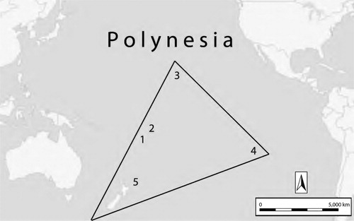
Polynesia is a good place to think about sites for several reasons. Islands, and island groups, provide good natural boundaries around study areas; the time period of human occupation is recent and short, beginning no earlier than 3800 B.P. (Burley, Weisler, and Zhao Citation2012), and in some cases less than 800 B.P. (Dye Citation2015); and the common sets of traditions and technologies mean there should be broad similarities in site types (Horsburgh and McCoy Citation2017). I end with three modest suggestions for moving forward that, while on their own not revolutionary, will be required to mitigate the inherently problematic aspects of the site concept—like the lack of a universal definition of what constitutes a site—that have been amplified by the “geospatial revolution” (Chase et al. Citation2012).
Background
Of the number of different advances in technology that contribute to the current deluge of digital data in archaeology, geospatial technologies are among the largest contributors and some of the most visible (Bevan Citation2015; Campana Citation2011, Citation2018; McCoy Citation2017, Citation2020). Geospatial technology, according to the American Association for the Advancement of Science (AAAS), “is a term used to describe the range of modern tools contributing to the geographic mapping and analysis of the Earth and human societies.” This includes Global Positioning Systems (GPS), Geographic Information Systems (GIS), remote sensing, and forms of online mapping, such as the digital globe Google Earth. For archaeology, there is a wide range of remote sensing tools, such as very high-resolution satellite imagery, airborne lidar, imagery from UAV, geophysical survey, and more, that are relevant.
There are technologies that are useful to include when talking about geospatial technologies that produce spatial data that are not always natively geospatial. These include instruments for high-density survey and measurement (HDSM), like terrestrial lidar, or photogrammetry, that allow us to create life-like models of the places where we find physical remains of the past (Opitz and Limp Citation2015). Other common examples of spatial data include excavation data generated from a total station tied to an arbitrary grid (x,y,z) and geophysical survey data. The integration of GPS within some of these tools means they can be configured to be natively geospatial. And of course, all these data can be scaled and placed in real world coordinates through post-processing.
There is also a great deal of geospatial and spatial data encoded in different types of databases outside of GIS that rely on the site concept (see also Lock and Pouncett Citation2017). Archaeologists have, for example, for many years adopted humanity’s oldest way to specify geolocation: toponyms. Names like “The Folsom Site,” are based on an existing toponym for the town of Folsom, New Mexico to refer to a site’s provenience. This method is inherently limiting and prone to confusion. As assigning collections to provenience became more formalized, and full-coverage survey resulted in recording hundreds or thousands of sites, there has been the adoption of project-specific site identifiers (e.g., Site 1), and regional ontologies, like the Smithsonian Trinomial Numbers. (In the Smithsonian system the Folsom Site becomes 29-CX-1; “29” is a numerical code for the State of New Mexico, “CX” is for Colfax County, and “1” is the first site number assigned in that county.) A site name and/or a unique identifier is a common part of many different kinds of archaeological datasets since it allows us to tag artifacts or laboratory results back to a geolocation without having to include real world coordinates. However, this presumes there will be long-term geospatial data continuity that allows us to place that site name or identifier in the real world, such as a survey map, GPS reading, or geodatabase. This is why site indices, and atlases, employ the site concept and are important to a range of different tasks, not just field surveys or spatial analyses.
The site concept presents well-known complications that are specific to geographic regions. In this paper I have brought together a number of examples from a region I know well, the islands of Polynesia, to highlight what I believe are problems common to many different parts of the world. I want to begin with a few caveats for those unfamiliar with the archaeology and history of Polynesia.
First, as is the case elsewhere, there is no consensus on what constitutes an archaeological site in Polynesia. That is understandable given how different these island landscapes can be. The archaeology of many parts of Aotearoa (New Zealand), for example, consists of earthworks, that in form, are not unlike Iron Age Europe. For large sections of the Hawaiian Islands the most common features are non-masonry stone structures that are, in form, not unlike features found in the American Southwest or Southern Africa. In contrast to those two examples, in places like Samoa, there are villages, paths, and abandoned fields that are difficult to survey on foot, but can be delineated on high quality aerial lidar; not unlike what is seen in the Maya area.
Second, the only shared temporal classification scheme for sites across the region is “pre-contact” and “post-contact.” The first people to discover and settle Polynesia began arriving no earlier than 3800 B.P., and in many cases no earlier than 800 B.P. (Horsburgh and McCoy Citation2017). The combination of historical linguistics, comparative ethnography, oral histories, and archaeology has allowed us to define a number of sub-regions, including Western Polynesia (e.g., Tonga, Samoa), which has the longest culture histories, and the most recent island groups to have been settled, Marginal Eastern Polynesia (e.g., the Hawaiian Islands, Rapa Nui [Easter Island], Aotearoa [New Zealand]). The founding peoples of Polynesia brought with them common sets of traditions, and what could be classified as Neolithic technologies, and then over many generations diverged to become 40 distinctive cultures encountered by European sailors during voyages of exploration in the 18th century (Kirch Citation2017). And so, while each island or island group has a distinctive culture history sequence from first arrival through first contact with Europeans; all have a post-contact period marked by various degrees of inclusion in the global capitalist economy, colonialism, and missionization. The studies referenced here are concerned primary with the pre-contact period.
Third, it is important to recognize that across Polynesia archaeological sites are often also cultural sites (Kawelu Citation2015). Virtually all islands have been continuously occupied by indigenous people through to the modern day, and so some of the most important sites are well-known and still in use. In other cases, the locations of sites, and their place in history, may be known to the local community, but not broadly shared for a number of reasons. There have been a few high profile cases where a site’s assessed scientific value was at serious odds with the interpretation and cultural value of the place to the community. In other cases, such as at Kahikinui on the island of Maui, the local community has welcomed archaeological research both for its contribution to knowledge discovery and as a way to aid in reclaiming land rights (Kirch Citation2014).
With those caveats—that there is no consensus on the definition of sites, assignment to temporal sequence is course-grained, and that many places are also cultural sites important to the local community—below I review recent studies that highlight the ways that geospatial technologies have complicated the site concept and several issues that, I believe, are common in many places around the world.
How Geospatial Technologies Complicate the Site Problem
Archaeology has known for a long time about the site problem. Advances in geospatial technologies adopted into archaeology have, depending upon one’s perspective, either solved the site problem, or given us a way to live with it, or made it worse. In my view, it has done all of these things and more. Recent developments in the archaeology of Polynesia do not fully represent all the ways archaeologists use geospatial technologies, nonetheless, they do highlight three important ways that the geospatial revolution has complicated the site problem:
higher resolution and more complete remote sensing surveys have resulted in site geodatabases that, for a number of reasons, resist straightforward assessment of precision, accuracy, and confidence (i.e., the rates of true/false, positive/negatives);
new fieldwork that produces born digital high-resolution survey data using UAV, terrestrial laser scanning, and other techniques, highlight how important where we choose to use these tools is to defining sites; and
the inherent conflict between obscuring the precise locations of sites from those who would loot or otherwise damage them, and sharing our results with the public to advocate for the protection of sites.
Assessing Site Detection and Mapping through Remote Sensing
The question of efficiency is often at the center of evaluating different methods for extracting a specific class of site from remotely sensed data (see also Opitz and Herrman Citation2018; Sevara et al. Citation2016). Two recent studies on islands in Western Polynesia are good examples of how the availability of high-resolution airborne lidar data has turned our attention to specific types of features. In the islands of Samoa, Quintus, Day, and Smith (Citation2017) have made the case for working back-and-forth between features manually detected and mapped onscreen and field mapped features, specifically terraces in a wide range of shapes and sizes. In the islands of Tonga, Freeland et al. (Citation2016) apply two different machine learning techniques to map more than 10,000 mounds, noting that these independent methods did not produce identical maps of mounds, but they did identify the same areas on the island as hot-spots. These contrasting approaches to assessing our ability to detect and map at the feature scale both rival what we can record on the ground and make sites somewhat irrelevant.
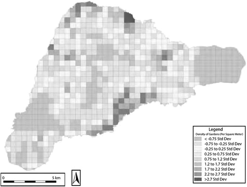
In some cases, the by-product of assessing accuracy, precision, and confidence, may be useful in terms of identifying where more systemic field survey is necessary. On Rapa Nui (Easter Island), Ladefoged, Flaws, and Stevenson (Citation2013) used World View II imagery of the entire island to estimate the amount of land transformed into gardens with a stone mulch component, commonly called rock gardens (). The stone in rock gardens likely served a number of purposes, including cutting down wind erosion and loss of soil moisture, and they have been the center of a number of field studies. These farming practices are often overlooked in the popular image of Rapa Nui as the location of ecological suicide, or ecocide (Diamond Citation2005).
Figure 2. Satellite Remote Sensing on Rapa Nui (Easter Island). Ladefoged, Flaws, and Stevenson (Citation2013) used satellite imagery to identify areas along the coast with a high density of garden features. These same areas were sources for a great deal of uncertainty in classification, suggesting that this region should be targeted for future field surveys. Source: Ladefoged, Flaws, and Stevenson (Citation2013).
The standard way to evaluate the success of a remote sensing classification is through a confusion index, or error index. A technique adopted from the natural sciences, a confusion index reports four variables: true positives, false positives, true negatives, and false negatives. Or put another way, how often locations highlighted are in fact the locations of sites (true positives), how often locations predicted to be sites are not sites (false positives), how often the remote sensing shows locations without sites in places that do in fact have no sites (true negatives), and how often known sites are missed (false negatives). One can also summarize these in a single statistic called the Kappa coefficient, or Cohen’s kappa coefficient, which produces an accuracy assessment with a p-value so that it can be determined if the results are better than what would come from a random classification of the study area (Cohen Citation1960).
In the study of Rapa Nui gardens by Ladefoged and colleagues high-resolution GPS data from seven inland training areas where full-coverage survey was conducted was used to create nine different categories of rock gardens, and 31 non-site classification categories, for their training data. The team used Gaussian Maximum Likelihood to create three different classifications and then assessed their results via the Kappa coefficient, rejecting the most conservative estimate as too close to random. The result was an estimate that between 2.5 to 12% of the entire island was gardened, with an accuracy of 55 to 74%. Importantly, they identified the coastal zone as heavily gardened but also a source a great deal of error, suggesting that more field survey work there would help refine the estimate.
Redefining Sites through High-Density Survey and Measurement
Remote sensing may be recording more features and sites than ever before, and at a level of detail rivaling field survey, but a suite of technology for high-density survey and measurement is changing the ways we define sites and features themselves. High-density survey and measurement (HDSM) has been defined as “the collective term for a range of new technologies that give us the ability to measure, record, and analyze the spatial, locational, and morphological properties of objects, sites, structures, and landscapes with higher density and more precision than ever before” (Opitz and Limp Citation2015, 347). This includes things like lidar (airborne, terrestrial, handheld), and photogrammetry, using imagery taken at close-range and via unpiloted aerial vehicles (UAV).
Field survey using HDSM complicates the site problem in three ways. First, unlike mapping, these tools do not require abstraction and interpretation for data capture. Huggett (Citation2015, this volume), and others, point out that, like other digital technologies, they make it more and more difficult to immediately detect what aspects of the data reflect patterns, or noise, in the real world and what reflect decision making by people creating, compiling, and displaying the data. The worry is that this may inhibit critical thought that mapping using more basic survey tools required. This is why new techniques that blend traditional fieldwork with other visual inputs from computers and/or virtual or augmented reality are necessary (e.g., Opitz and Johnson Citation2015). A related issue raised by Huggett is how technology is fetishized, which is dangerous in that it makes it even less likely that archaeologists will stop and consider what decisions went into creating data, and new technologies may spread more rapidly than the wisdom it takes to use them.
Second, the application of HDSM instruments create a digital environment where defining sites is optional, leaving it up to the archaeologist to experiment and innovate with new methods and units of observation. A recent survey on Great Mercury Island, a small off-shore island (1,740 hectares) in Aotearoa (New Zealand) is a good example of this type of experimentation and innovation. Previous surveys had defined 97 sites on the island, however, on reconnaissance it was clear that a range of different features were present in a more-or-less continuous fashion. A full-coverage survey would produce an enormous amount of data, much of it redundant if the goal is a rigorous, but general, assessment of the landscape.
McIvor and Ladefoged (Citation2015) focused on a 300-hectare area that was divided into an arbitrary grid of 25 × 25 meter land units, which included 16 previously recorded sites. The survey team visited more than 3,000 locations using high precision GPS and found archaeology within 300 land units. Within each land unit a limited number of formal and functional categories of features were assessed for presence or absence. This data was then scaled up through a series of increasing adjacent neighborhoods to address the modifiable areal unit problem, or MAUP (Openshaw Citation1983). MAUP occurs when the size and shape of aggerating units creates bias. It is a well-known problem in geography but something archaeologists rarely build into a research design (Harrower Citation2012). The result was a robust distribution map of different types of features that helped resolve some basic questions about the kinds of activities and settlement pattern on the island.
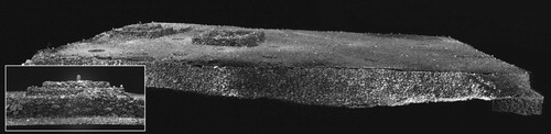
Third, the application of HDSM exposes how sites are defined, sometimes unintentionally, by where we choose to focus our HDSM instruments (). For UAV survey, for example, the practical limitations of the scope of the fieldwork, which as VanValkenburgh (this volume) discusses, are defined not just by the technology, but also by a number of local political considerations. Some of these same concerns impact satellites and air photography, but are more relevant for a UAV survey because of the necessity of land access and the extremely high level of resolution of the imagery. Even in cases where access is less of an issue, assumptions about the extent of a site will dictate what area is recorded. For example, terrestrial laser scanning has been applied on the largest classes of pre-contact era architecture in the Hawaiian Islands, temples (heiau) (e.g., Mulrooney et al. Citation2005) and in Aotearoa (New Zealand), earthwork fortifications (pa), (e.g., McIvor Citation2015). These projects have generally been aimed at doing what HDSM does best; tasks like measuring the volume of building material, and defining surface features through micro-topography. Scanning for heritage preservation, popularized by CyArk and others, is becoming more and more common. But, one thing we should think about is the fact that to viewers who are not archaeologists the edges of our 3D models define the site for them by limiting their sight.
Figure 3. Terrestrial Lidar Scan of Hikiau Heiau, Hawai‘i Island. This 3D model is a good example of how documentation of a Hawaiian temple, in this case an important cultural site within the Kealakekua royal center, can show remarkable details and but fail to show how it fits within the surrounding complex. It is also a good example of how places can accumulate legacy and nested site numbers. The temple (heiau), shown here, is known by two site numbers, the State of Hawaii’s site number (50-10-47-3732) and an abandoned system used by the Bishop Museum (50-Ha-C23-001). The temple complex has a site number, although its boundaries are unknown, and it is all part of a larger historic district, that again, has its own site number. Source: McCoy (Citation2018b).
Deciding to Obscure or Show Site Locations in Site Geodatabases
Perhaps the strongest argument for the continued use of the site concept is the fact that they can be a useful record locator identifier for data repositories and indices. Generally, data repositories, like The Digital Archaeological Record (tDAR) are omnivores, taking in static datasets no matter how sites were defined by the original recorders. While tDAR’s repository is a collection of static datasets, there is also an attempt to impose a generic site classification scheme. A total of more than 100 site types are nested into three hierarchical levels, with the most general at the top of the scheme (e.g., the primary class “Domestic Structure or Architectural Feature”), and increasing in specificity (e.g., the class “Settlement” has the further sub-classification “Encampment”). Each type is given a brief description online. This function gives tDAR the capacity for making site data interoperable, ideally speaking, although specifying this level of site information is not a requirement to contribute data.
Online data repositories, site indices, and atlases each must decide what locational information must be obscured from public view and what must be shared in order for the content to have a meaningful impact. There is no one-size-fits-all, and in practice, the ways these sources will obscure and share can be thought of as being on a continuum. The Digital Archaeological Record, for example, will only show bounding boxes on their online map. These boxes tend to be specific enough to allow for searching by map but broad enough to obscure site locations; locations that may, or may not, be available for download.
Site indices also expend a great deal of effort to achieve data interoperability and integration, and importantly for the site concept, are built to engage the public. The Digital Index of North American Archaeology (DINAA) is a good example of keeping the location of sites obscured to keep them from suffering from unwanted visitation by those who would do harm, especially looters, but also from the degradation to sites that can come from uncontrolled access by an interested general public. The total size of the geodatabase is soon set to pass 750,000 sites, but what is shown online are hundreds of polygons color coded to show site density. Even with this measure in place, much of the middle section of the United States has yet to be included within the site index; a gap that likely includes millions of existing site records.
The collective known as Endangered Archaeology in the Middle East and North Africa (EAMENA) takes a different approach. Much of their website’s design centers on the notion that it is only by drawing attention to sites that we can educate people about the past, alert the public to the damage done to sites by looting, but also the damage done by development, agriculture, and natural disasters. This design element is, in part, why the EAMENA website looks much more complete and allows for searches of individual sites that can include a polygon showing the extent of the site overlaid on a satellite image. Using just these two examples, DINAA and EAMENA, the casual user would think that the Middle East is full of sites and the middle of America has no sites. In reality, there are many more known sites in both regions that are not shown.
The largest site index in Polynesia includes more than 68,000 sites and is called ArchSite. It is maintained by the non-profit organization the New Zealand Archaeological Association. Aotearoa (New Zealand) is by far the largest landmass of any island group in the region (). The history of archaeology is as old as anywhere in Polynesia, and early studies focused on defining a culture history and the disappearance of flightless birds called moa. Davidson (Citation1984) wrote the first overall summary of the archaeology of New Zealand, which at that point included a site-recording scheme that was used alongside commonly used site names. Site identifiers have since been updated. Currently they are linked to an arbitrary grid where areas are given an alphanumeric code (e.g., for the site P05/195; “P05” refers to grid P05, and “195” is the site number).
Figure 4. Example of Public Access to ArchSite Online Geodatabase. Note that while previously recorded sites are represented, and site numbers given, the specific location and other details are obscured. Source: http://www.archsite.org.nz/
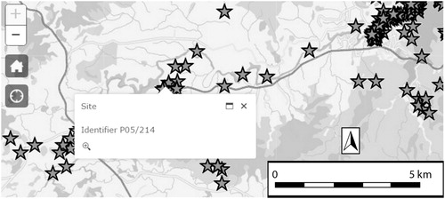
With some exceptions, geospatial technology has generally not transformed how sites have been recorded, but it has allowed archaeologists to create a single platform where past practices could be preserved, or revised. For example, ArchSite continues to follow a one-point-per-site data model, a practice that dates back to the original two-page site recording form, where a UTM location was estimated from white paper maps. It also serves as the primary clearing house for digital versions of site forms, sketch maps, and any other information that users may upload. At the same time, ArchSite has been a useful platform for rewriting the site type classification scheme and has been instrumental in sharing the results of a major upgrade to regional site records, which involved trying to relocate sites, record their locations with GPS, and assess their condition.
The site recording scheme, and specifically the ArchSite geodatabase, has been instrumental in several large-scale research projects focused on paleodemography (McCoy Citation2017), the potential impacts of sea level rise on known sites (McCoy Citation2018a), social network analysis (Ladefoged et al. Citation2019), and the changing character of warfare over time (McCoy and Ladefoged Citation2019). Looking closer at these studies, there are ways in which the point data model of sites has been problematic. In assessing the potential impacts of sea level rise, for example, the point representing a site returned a different elevation estimate depending upon the resolution of the elevation model, which could alter drastically when we would presume damages from rising seas would begin. More importantly, because these are points, rather than polygons or rasters, there is a great deal of uncertainty about how well this data can model future impacts even given good resolution topographic information. Further, when site locations were used in artifact or radiocarbon databases, there is the real worry about the unwarranted conglomeration of samples from different time periods, or, misrepresenting a site as from a single time period because only one date was reported.
Discussion
Given both the theoretical problems with defining sites, and all the options we now have in terms of recording locational information, why do we continue to cling to the notion of sites? One could argue that while we have had digital data recording options for a long time we have only just crossed a critical threshold in terms of humanity’s capacity to create, store, share, and analyze in a completely digital, and site-less, workflow. But, I do not think it is just a question of archaeology catching up to advances in Big Data. We keep coming back to the site concept, and in my view will likely will continue to do so, for some of the same reasons that biologists continue to use the species concept.
For a long time, what defined a species was the ability to have offspring that are also capable of having offspring. The problem is species are more fluid than that. The massification of DNA data has shown that species are not discrete, bounded units and there are about 30 different definitions for species, such as morphospecies (i.e., species in the classical sense), genetic species, species defined by the Least Inclusive Taxonomic Unit or the Evolutionary Significant Unit, and so on. It is no wonder that “[t]he ontological, or metaphysical, status of species is one of the most contentiously debated issues in the philosophy of biology” (Zachos Citation2016, 167). The continued use of the term species, even with the ability to describe individuals and populations at a molecular level, speaks to its utility in organizing datasets, describing new data, designing research, and discussing results. While the analogy is not perfect, I would argue that there is a parallel between the species concept in biology and the site concept in archaeology. Geospatial technology, like modern DNA techniques, allow the creation of continuous datasets at different scales of resolution making sites unnecessary; and yet we continue to use the site concept in many, but not all, contemporary studies.
The reason that I have highlighted how remote sensing resists straightforward assessment of precision, accuracy, and confidence, is not to discredit remote sensing as a way of collecting locational information. Quite the opposite. My goal has been to show how these studies complicate the site concept, so much so, that perhaps just as there are different definitions of species, we need to define remotely sensed sites and features as their own category, separate, but not unrelated, to how we define sites through direct observation on field survey and excavations.
One could argue that, in practice, we already accept remotely sensed sites as a different category of sites than sites as defined by fieldwork. It is widely recognized that not all remotely sensed data is equal in terms of appropriateness for detection and mapping, and that not all archaeological targets are equally likely to be identified. Therefore, each study must be customized with sensitivity to the data and archaeological target. Remote sensing results will always have these elements embedded in them, even if they are improved through ground truthing, or the application of a confusion index to quantify uncertainty. To be clear, I am not arguing against ground truthing or other efforts to improve the quality of remotely sensed site data. I am arguing that perhaps it is time to accept remotely sensed sites on their own terms, and concentrate efforts on setting high standard for metadata that tells the end user how it was made, and paradata, that makes it more likely that it will be used beyond the original study (McCoy Citation2017).
Regardless of how sites are detected or mapped, we need to shift how we talk about sites when we are communicating to other scholars, communities, and the public (McCoy Citation2020). Specifically, it is critical to make it clear that sites are not what we are looking for; they are the locations where we have found things. One comparison that I suggest may work is to explain that sites are like street addresses. They are useful as a shorthand that helps us organize things, like an address, but they are not the same as the things that are located in those places, the building at that address. I have made the case that the use of high-density survey and measurement instruments complicate the notion of site in a number of ways, including by embedding our choices of where to make field observations in the data. Here again, the non-archaeologist audience cannot be expected look at nicely bounded 3D models and know intuitively that where a 3D model begins and ends is the result of a number of practical considerations. In technical terms, sites are better thought of as locations of archaeological practice; locations that we can revisit in their digital form.
Finally, the DINAA and EAMENA databases are just two of many online site indices documenting the massification of site data (see McCoy Citation2017 for an extensive list of geodatabases). And if there is one thing that these geodatabases show it is that while sites are precious, they are not rare. This might be taken for granted by professional archaeologists, but for the public, it is often news that there is archaeology where they live. Sometimes ignorance is due to a genuine lack of known sites, but more likely, hundreds or thousands of sites will have been recorded. As data repositories and indices evolve and grow, we must confront the inherent conflict between the need to protect sites by obscuring their locations, and the need to advocate for their protection by sharing the locations of sites since these geodatabases have benefits for cultural resource management, heritage, and academic research.
Conclusion
The site concept in archaeology is no longer universal, thanks in part to advances in geospatial technology. But, sites are not going away, as they are useful ways to geotag and link data across digital technology. I have made the case that sites identified through remote sensing have, in practice, grown to occupy a different definition for what constitutes a site than the traditional way we have defined sites through direct observation in the field through survey and excavations. In addition, our ability to capture high-resolution continuous locational datasets, while offering a number of advantages in field recording, may inadvertently give the impression that the limits of our data correspond to the boundaries of sites, rather than simply where we have looked, or recorded. I suggest one way to avoid this is to make it clear to non-archaeological audiences that sites are like street addresses, a shorthand for where we have made field observations, or collected objects. Geospatial technologies have also brought to the fore an enduring conflict between protecting sites by obscuring their location, and displaying location as a prerequisite of advocating for site protection. While we continue to see new ways to balance these, one thing that we must get across to a broader audience is the message that sites are precious but they are not rare.
Acknowledgments
This paper builds on my discussion of presentations at a session of the 2019 Society of American Archaeology organized by Parker VanValkenburgh and Andrew Dufton. I want to thank them both for the invitation and to all the participants for sharing their work ahead of the conference and their suggestions regarding the site concept in the digital age. The final paper was helped enormously by comments from the editors of this special edition of the journal and two anonymous reviewers. Special thanks to Thegn N. Ladefoged for discussions on this topic.
Notes on Contributor
Mark D. McCoy (Ph.D. 2006, University of California, Berkeley) is an Associate Professor in the Department of Anthropology at Southern Methodist University. His expertise is in the application of geospatial technology in archaeology. He is a landscape archaeologist whose research centers on the development of ancient political economies and human ecodynamics with a regional focus on the islands of the Pacific.
ORCID
Mark D. McCoy http://orcid.org/0000-0002-1929-1579
References
- Anschuetz, K., R. H. Wilshusen, and C. L. Scheick. 2001. “An Archaeology of Landscapes: Perspectives and Directions.” Journal of Archaeological Research 9 (2): 157–211.
- Bailey, G. 2008. “Time Perspectivism: Origins and Consequences.” In Time in Archaeology: Time Perspectivism Revisited, edited by S. Holdaway and L. Wandsnider, 13–30. Utah: Utah University Press.
- Bailey, G. 1981. “Concepts, time-scales and explanations in economic prehistory.” In Economic Archaeology, edited by A. Sheridan and G. Bailey, 97–117. British Archaeological Reports International Series 96. Oxford: BAR.
- Banning, E. B. 2002. Archaeological Survey. Manuals in Archaeological Method, Theory and Technique. New York: Springer.
- Bevan, A. 2015. “The Data Deluge.” Antiquity 89: 1473–1484.
- Binford, L. R. 1981. “Behavioral Archaeology and the ‘Pompeii Premise.’” Journal of Anthropological Research 37: 195–208.
- Binford, L. R. 1992. “Seeing the Present and Interpreting the Past—and Keeping Things Straight.” In Space, Time, and Archaeological Landscapes, edited by J. Rossignol and L. Wandsnider, 43–64. New York, NY: Plenum Press.
- Burley, D., M. I. Weisler, and J. Zhao. 2012. “High Precision U/Th Dating of First Polynesian Settlement.” PLoS ONE 7: e48769.
- Campana, S. R. L. 2011. “‘Total Archaeology’ to Reduce the Need for Rescue Archaeology: The BREBEMI Project.” In Remote Sensing for Archaeological Heritage Management, edited by D. C. Cowley, 33–41. Brussels: Europae Archaeologia Consilium.
- Campana, S. R. L. 2018. Mapping the Archaeological Continuum: Filling ‘Empty’ Mediterranean Landscapes. New York: Springer.
- Chase, A. F., D. Z. Chase, C. T. Fisher, S. J. Leisz, and J. F. Weishampel. 2012. “Geospatial Revolution and Remote Sensing LiDAR in Mesoamerican Archaeology.” Proceedings of the National Academy of Sciences 109: 12916–12921.
- Cohen, J. 1960. “A Coefficient of Agreement for Nominal Scales.” Educational and Psychological Measurement 20 (1): 37–46.
- Conyers, L. B. 2013. Ground-Penetrating Radar for Archaeology. 3rd edition. Landham, MD: Alta Mira Press.
- Davidson, J. 1984. The Prehistory of New Zealand. Auckland: Longman Paul.
- Diamond, J. 2005. Collapse: How Societies Choose to Fail or Succeed. New York: Penguin Books.
- Dunnell, R. C. 1992. “The Notion Site.” In Space, Time, and Archaeological Landscapes, edited by J. Rossignol and L. Wandsnider, 21–41. Interdisciplinary Contributions to Archaeology. Boston, MA: Springer.
- Dunnell, R. C., and W. S. Dancey. 1983. “The Siteless Survey: A Regional Scale Data Collection Strategy.” In Advances in Archaeological Thought in America, edited by M. B. Shiffer, 149–207. New York, NY: Academic Press.
- Dye, T. S. 2015. “Dating Human Dispersal in Remote Oceania: A Bayesian View from Hawai‘i.” World Archaeology 47: 661–676.
- Freeland, T., B. Heung, D. V. Burley, G. Clark, and A. Knudby. 2016. “Automated Feature Extraction for Prospection and Analysis of Monumental Earthworks from Aerial LiDAR in the Kingdom of Tonga.” Journal of Archaeological Science 69: 64–74.
- Harrower, M. J. 2012. “Methods, Concepts and Challenges in Archaeological Site Detection and Modeling.” In Mapping Archaeological Landscapes from Space, edited by D. Comer and M. J. Harrower, 213–218. New York: Springer.
- Hilbert, M., and P. López. 2011. “The World's Technological Capacity to Store, Communicate, and Compute Information.” Science 332 (6025): 60–65.
- Hill, A. C., F. Limp, J. Casana, E. Jakoby Laugier, and M. Williamson. 2019. “A New Era in Spatial Data Recording: Low-Cost GNSS.” Advances in Archaeological Practice 7 (2): 169–177.
- Holdaway, S., and L. Wandsnider, eds. 2008. Time in Archaeology: Time Perspectivism Revisited. Salt Lake City: University of Utah Press.
- Horsburgh, K. A., and M. D. McCoy. 2017. “Dispersal, Isolation, and Interaction in the Islands of Polynesia: A Critical Review of Archaeological and Genetic Evidence.” Diversity 9 (37), doi:10.3390/d9030037.
- Howey, M. C. L., and M. Brouwer Burg. 2017. “Assessing the State of Archaeological GIS Research: Unbinding Analyses of Past Landscapes.” Journal of Archaeological Science 84: 1–9.
- Huggett, J. 2015. “A Manifesto for an Introspective Digital Archaeology.” Open Archaeology 1: 86–95.
- Kantner, J. 2008. “The Archaeology of Regions: From Discrete Analytical Toolkit to Ubiquitous Spatial Perspective.” Journal of Archaeological Research 16 (1): 37–81.
- Kawelu, K. L. 2015. Kuleana and Commitment: Working Toward a Collaborative Hawaiian Archaeology. Honolulu: University of Hawaii Press.
- Kirch, P. V. 2017. On the Road of the Winds: An Archaeological History of the Pacific Islands before European Contact. Second Edition. Berkeley: University of California Press.
- Kirch, P. V. 2014. Kua‘Āina Kahiko: Life and Land in Ancient Kahikinui, Maui. Honolulu: University of Hawaii Press.
- Kvamme, K. L. 1999. “Recent Directions and Developments in Geographical Information Systems.” Journal of Archaeological Research 7 (2): 153–201.
- Kvamme, K. L. 2003. “Geophysical Surveys as Landscape Archaeology.” American Antiquity 68: 435–457.
- Ladefoged, T. N., C. Gemmell, A. Jorgensen, H. Glover, C. Stevenson, M. D. McCoy, and D. O. O’Neale. 2019. “Social Network Analysis of Obsidian Artefacts and Maori Interaction in Northern Aotearoa New Zealand.” PLoS ONE 14 (4): e0212941.
- Ladefoged, T. N., A. Flaws, and C. M. Stevenson. 2013. “The Distribution of Rock Gardens on Rapa Nui (Easter Island) as determined from Satellite Imagery.” Journal of Archaeological Science 40 (2): 1203–1212.
- Lasaponara, R., and N. Masini. 2012. Satellite Remote Sensing: A New Tool for Archaeology. New York: Springer.
- Lin, A. Y.-M., A. Huynh, G. Lanckriet, and L. Barrington. 2014. “Crowdsourcing the Unknown: The Satellite Search for Genghis Khan.” PLoS One 9: e114046.
- Lock, G., and J. Pouncett. 2017. “Spatial Thinking in Archaeology: Is GIS the Answer?” Journal of Archaeological Science 84: 129–135.
- Lucas, G. 2005. The Archaeology of Time. New York: Routledge.
- McCoy, M. D. 2017. “Geospatial Big Data in Archaeology: Prospects and Problems too Great to Ignore.” Journal of Archaeological Science 84: 74–94.
- McCoy, M. D. 2018a. “The Race to Document Archaeological Sites Ahead of Rising Sea Levels: Recent Applications of Geospatial Technologies in the Archaeology of Polynesia.” Sustainability 10: 185. doi:10.3390/su10010185.
- McCoy, M. D. 2018b. “Celebration as a Source of Power in Archaic States: Archaeological and Historical Evidence for the Makahiki Festival in the Hawaiian Islands.” World Archaeology 50 (1): 242–270.
- McCoy, M. D. 2020. Maps for Time Travelers: How Archaeologists Use Technology to Bring Us Closer to the Past. Oakland: University of California Press.
- McCoy, M. D., and T. N. Ladefoged. 2009. “New Developments in the use of Spatial Technology in Archaeology.” Journal of Archaeological Research 17 (3): 263–295.
- McCoy, M. D., and T. N. Ladefoged. 2019. “In Pursuit of Māori Warfare: New Archaeological Research on pre-European Contact Warfare.” Journal of Anthropological Archaeology 56: 101113.
- McIvor, I. H., and T. N. Ladefoged. 2015. “A Multi-Scalar Analysis of Māori Land use on Ahuahu (Great Mercury Island), New Zealand.” Archaeology in Oceania 51 (1): 45–61.
- McIvor, I. H. 2015. “Monumental Ideology: a GIS Spatial Analysis of Interior features of Matakawau Pa, Ahuahu (Stingray Point Pa, Great Mercury Island), New Zealand.” Journal of the Polynesian Society 124 (3): 269–302.
- Mulrooney, M. A., T. N. Ladefoged, R. Gibb, and D. McCurdy. 2005. “Eight Million Points per day: Archaeological Implications of Laser Scanning and Three-Dimensional Modeling of Pu‘Ukohola Heiau.” Hawaiian Archaeology 10: 18–28.
- Olson, K. G., and L. M. Rouse. 2018. “A Beginner's Guide to Mesoscale Survey with Quadrotor-UAV Systems.” Advances in Archaeological Practice 6 (4): 357–371.
- Openshaw, S. 1983. The Modifiable Areal Unit Problem. Norwick: Geo Books.
- Opitz, R., and J. Herrman. 2018. “Recent Trends and Long-Standing Problems in Archaeological Remote Sensing.” Journal of Computer Applications in Archaeology 1: 19–41.
- Opitz, R. S., and T. D. Johnson. 2015. “Interpretation at the Controller's Edge: Designing Graphical User Interfaces for the Digital Publication of the Excavations at Gabii (Italy).” Open Archaeology 1: 274–290.
- Opitz, R., and W. Limp. 2015. “Recent Developments in High-Density Survey and Measurement (HDSM) for Archaeology: Implications for Practice and Theory.” Annual Reviews in Anthropology 44: 347–364.
- Parcak, S. 2019. Archaeology from Space: How the Future Shapes Our Past. New York: Henry Holt and Co.
- Patrik, L. E. 1985. “Is There an Archaeological Record?” Advances in Archaeological Method and Theory 8: 27–62.
- Quintus, S., S. S. Day, and N. J. Smith. 2017. “The Efficacy and Analytical Importance of Manual Feature Extraction Using Lidar Datasets.” Advances in Archaeological Practice 5: 351–364.
- Schiffer, M. B. 1972. “Archaeological Context and Systemic Context.” American Antiquity 37 (2): 156–165.
- Schiffer, M. B. 1976. Behavioral Archeology. New York, NY: Academic Press.
- Schiffer, M. B. 1987. Formation Processes of the Archaeological Record. Albuquerque, NM: University of New Mexico Press.
- Sevara, C., M. Pregesbauer, M. Doneus, G. Verhoeven, and I. Trinks. 2016. “Pixel Versus Object—A Comparison of Strategies for the Semi-Automated Mapping of Archaeological features using Airborne Laser Scanning Data.” Journal of Archaeological Science: Reports 5: 485–498.
- Thomas, D. H. 1975. “Nonsite Sampling in Archaeology: Up the Creek Without a Site?” In Sampling in Archaeology, edited by J. W. Mueller, 61–81. Tucson: University of Arizona Press.
- Zachos, F. E. 2016. Species Concepts in Biology: Historical Development, Theoretical Foundations and Practical Relevance. New York: Springer.