
ABSTRACT
Archaeologists study many phenomena that scale beyond even our most geographically expansive field methodologies. The promise of collecting archaeologically relevant data beyond the scale of regional surveys is among the most exciting prospects of the “data revolution.” Yet previous efforts have either struggled to generate high-quality data within expansive regions or to use well-edited interregional datasets to address novel research questions. We discuss the development of two collaborative research projects that seek to address these problems—GeoPACHA (Geospatial Platform for Andean Culture, History and Archaeology) and LOGAR (Linked Open Gazetteer of the Andean Region). The former is an online platform facilitating virtual archaeological survey of satellite and historical aerial imagery; the latter collates primary source information on Andean places. We illustrate the potential of both tools through presentation and analysis of a comprehensive basemap of the planned colonial towns built during a mass resettlement program instituted in the viceroyalty of Peru in the 1570s C.E.
Introduction
Until very recently, archaeological knowledge has been almost entirely captive to field-based methodologies. This essential orientation is so paradigmatic that its fundamental limitations are easily ignored or overlooked. Yet the manner in which archaeological data are produced and distributed often stifles our ambition to trace past human experience beyond the scale of the regional frames of reference produced through fieldwork. Archaeological field and laboratory research are labor intensive, and even the largest survey projects cover areas only reaching at most a few thousand square kilometers (Adams Citation1981; Barker et al. Citation1996a, Citation1996b; Bauer and Covey Citation2002; Blanton et al. Citation1981, Citation1999; Daniels Citation1970; Mattingly Citation2004; Sanders Citation1970). Exacerbating these limitations, archaeological datasets are typically tailored to the research interests of individual projects, making data aggregation and inter-project comparison challenging even when data are made publicly available. Thus, despite the fact that even in deep antiquity, social, political, and economic networks frequently exceeded the scales of individual valleys and urban areas (Algaze Citation1993; Chase-Dunn and Hall Citation1991; Jennings Citation2014), archaeologists have found it challenging to chart the ebb and flow of social life at interregional scales. Tellingly, perhaps, archaeological maps of interregional phenomena such as empires, diasporas, and continental-scale economic networks tend to resemble either homogeneous “blobs” on maps or schematic wheel-and-spoke diagrams (Smith Citation2005, Citation2007).
These problems are especially acute in the Andes. The region’s high relief makes large scale survey quite challenging in many of its landscapes, and geographic fragmentation has tended to foster inward-looking studies compared to research in well-surveyed areas such as the eastern Mediterranean and highland Mesoamerica, despite the fact that the Andes were home to the earliest and largest prehispanic empires in the Americas, the Wari and the Inka. Andeanist researchers have tended to work in project-based silos, with data sharing limited to informal exchanges within small regional research communities or through published articles and monographs. At the same time, more Andean archaeological sites are being destroyed than ever, as urban development, mining, and industrial agriculture expand into previously unoccupied lands, fueled by rapid economic growth in the Andean republics since the mid 1990s.
A flurry of recent technological and methodological advances in remote sensing, photogrammetry, and machine learning open new possibilities for interregional perspectives. These approaches use high resolution imagery to locate archaeological features over very large areas. To date, the largest virtual surveys have used “brute force” methods that use trained teams of researchers to tag sites one by one (Casana Citation2014; Casana and Cothren Citation2013), but recent advances in computer vision and machine learning—particularly approaches using convolutional neural networks—show promise for artificial intelligence-aided virtual survey (Trier, Larsen, and Solberg Citation2009; Trier, Cowley, and Waldeland Citation2019).
Yet the promise of such “big” archaeology also presents several empirical, conceptual, and ethical challenges. Most obviously, virtual prospection necessarily focuses on sites with surficially visible—mostly architectural—remains, which tend toward the upper tiers of settlement hierarchies. In this scenario, there is a real risk that sample bias may likewise influence analysis, leading to top-down framings of social processes that occlude local variation. Second, all machine learning-based automated prospection systems require large, human-generated training datasets, raising ethical and intellectual issues of authorship. Third, many automated computer vision systems are ultimately black boxes; for example, the way in which a neural network learns to identify objects cannot be known with any precision, and this raises fundamental epistemological problems.
Clearly, the promise of virtual archaeological prospection is scalar: it holds the potential to dwarf pedestrian survey in spatial extent, opening new possibilities for understanding past landscapes. But its methodological, analytical, and ethical hazards are equally clear. We argue that these hazards are in many ways analogous to (if not also products of) the kind of high modernist vision criticized in Scott’s (Citation1998) Seeing Like a State. That is, as high modernists invented systems of classification that vastly simplified social and environmental arrangements in order to render them legible, so do interregional virtual surveys vastly simplify remotely sensed raster data in order to capture archaeologically relevant information. Thus, as the inherent problems of legibility and simplification contributed to myopic state ordered schemes and failed to improve the lives of the citizenry, so virtual archaeological survey risks imposing top-down theoretical schema and failing to account for the emergent properties of human interaction at smaller scales.
This paper explores methodological, analytical, and ethical issues raised by interregional scale, imagery-based archaeological prospection made possible by brute force methods and computer vision-based machine learning. We report on progress with two online collaborative platforms for virtual archaeological survey and the aggregation of place-based data in the Andean region, GeoPACHA (Geospatial Platform for Andean Culture, History and Archaeology) and LOGAR (Linked Open Gazetteer of the Andean Region) (Wernke and Saito Citation2019). The two platforms serve distinct but complementary functions. GeoPACHA is an open source, browser-based geospatial platform for discovering and documenting archaeological sites in the Andes through systematic visual survey of satellite and historical aerial imagery by a network of trained teams. The objective of GeoPACHA is to cover many tens of thousands of square kilometers via manual visual inspection with an international network of collaborating researchers, the results of which will be used directly for analytical purposes and for training convolutional neural networks to autonomously conduct even larger scale automated imagery survey. LOGAR is a gazetteer that collates primary source information on places relevant to Andean studies, focusing initially on the planned colonial towns established during the Reducción General de Indios (General Resettlement of Indians; hereafter “Reducción”), a massive forced resettlement campaign instituted throughout much of the viceroyalty of Peru during the 1570s C.E.
Virtual Archaeology: Epistemological and Methodological Considerations
As the contributions to the issue attest, archaeology is in the midst of a digital revolution, spurred on by the proliferation of new tools and datasets that allow capture and analysis of field data in exciting ways (Averett, Gordon, and Counts Citation2016). The decreasing cost and wider availability of both declassified historic satellite photographs and high-resolution multi-spectral satellite imagery have begun to allow us to identify thousands of new archaeological sites at large scales—in some cases in areas spanning tens or even hundreds of thousands of square kilometers (Casana Citation2014; Parcak Citation2009; Parcak Citation2019; Ur Citation2003, Citation2006, Citation2010). Advances in photogrammetric tools and techniques enable processing of large historical aerial survey collections, enabling the production of high resolution 3D models, orthomosaics, and digital elevation models over large areas, which in turn enables detection and analysis of archaeological features that have since been destroyed or that have degraded considerably since the aerial photographs were taken (Wallace Citation2017).
As archaeologists have explored the potential of these new tools and datasets, distinct approaches have emerged in the interpretation of satellite remote sensing data for archaeological prospection. Using so-called “brute force” methods (Casana Citation2014; Casana this volume), small teams of highly-trained researchers visually scan imagery and then tag archaeological features one by one. The largest published example of this approach is the CORONA Atlas of the Middle East, which documented over 10,000 archaeological sites through visual survey of 1,008 declassified CORONA satellite images in a 300,000 sq km area in the greater Middle East (Casana Citation2014; Casana and Cothren Citation2013). Similarly, “citizen science” or crowdsourcing approaches rely on human classification but employ thousands of relatively untrained eyes to tag features in the same areas of interest, which are prioritized for feature creation based on the number of people who tag them. GlobalXplorer is a notable citizen science archaeological project, with a focus on cultural heritage conservation and management by mapping evidence for active looting and site destruction (Parcak Citation2019).
In contrast, automated feature detection employs algorithmic or machine learning approaches to filter through datasets and tag areas whose textures, forms, and spectral properties are characteristic of archaeological sites in specific regions (Harrower et al. Citation2013; Schuetter et al. Citation2013; Menze, Ur, and Sherratt Citation2006; Menze and Ur Citation2012; Tansey et al. Citation2009). Automated detection employing high resolution multispectral satellite imagery has so far had limited success (Casana Citation2014, 223–224). Exploratory analysis of multispectral data has enabled sites and features to be mapped in specific conditions, such as spectrally distinct plant communities atop terra preta anthrosols in Amazonia (Heckenberger et al. Citation2008; McMichael et al. Citation2014) and the extents of Maya centers based on the distinct plant health on limestone architecture and surrounding forest (Saturno et al. Citation2006). In the Middle East, Menze and Ur (Citation2012) have used automated detection to map thousands of tell sites based on their morphology in digital elevation models and the spectral properties of their anthropogenic soils. However, in many studies, distinctive spectral properties of sites have proven indiscernible, due to inter-site variability or indistinguishability from surrounding landforms and land cover (Alexakis et al. Citation2009; De Laet, Paulissen, and Waelkens Citation2007; Garrison et al. Citation2008; Wilkinson, Beck, and Philip Citation2006). Advances in object-oriented approaches, which focus on the edges and shapes of objects in images (Blaschke Citation2010; Blaschke et al. Citation2014) have met with limited success in automated detection of sites with distinctive shape features such as circular crop marks (Trier, Larsen, and Solberg Citation2009) and linear features such as ancient roads (De Laet, Paulissen, and Waelkens Citation2007).
Despite the promise of citizen science and automated feature detection for imagery-based mapping of archaeological sites at regional scale, “brute force” methods currently remain the most effective means of producing high quality interregional archaeological datasets from satellite imagery (Casana Citation2014; Casana, this volume). Crowdsourced feature identification has proven challenging for archaeological applications. In contrast to the application of broadly shared typological knowledge to images of common phenomena—say, the distinction between dogs and cats and the tagging of crosswalks—even the most basic identification of archaeological features requires highly trained vision. These problems are exacerbated when projects extend over larger geographic areas, as the diversity of forms and features tends to increase and make consistent classification even more challenging. Employing crowdsourcing as an initial step for tagging possible features, followed by supervised editing to eliminate false positives and fill out attribute data may hold promise for improving the efficiency of human-based classification.
Yet both team-based and crowdsourced visual surveys of imagery remain fundamentally tedious and expensive. New developments in deep machine learning approaches to computer vision show great promise for automating some elements of imagery-based archaeological prospection beyond the regional scale. Convolutional Neural Networks (CNNs) lead this field, and in the last few years have begun to match and even exceed human capabilities for object identification accuracy in images (Krizhevsky, Sutskever, and Hinton Citation2012). However, a fundamental precondition for all CNN systems is that they require large training datasets for reliable object identification (Goodfellow, Bengio, and Courville Citation2016). Outside of archaeology, CNN applications have relied on massive online training data repositories produced through mechanical turk methods (i.e., crowdsourced, human-identified object identifications) (Deng et al. Citation2009; Russakovsky et al. Citation2015).
Attending to problems of sampling bias is fundamental to establishing a firm empirical basis for virtual survey methodologies. These biases derive from the epistemological limits of the imagery data sources themselves, and from interobserver differences in sensitivity and specificity. The first source—the inherent limitations of surficial visibility relative to imagery resolution—defines the upper limit of the sensitivity (true positive rate) of a virtual survey. Thus, even with a perfect detection rate (no false positive or false negative feature identifications), imagery-based survey cannot discern the true distribution of archaeological features in past landscapes. It can only discern which features are surficially visible and of sufficient scale for detection in the imagery. Of course, perfect detection rates are unrealistic in any survey (field-based or virtual), as the features of interest are fuzzy sets, and some inter-observer error is unavoidable.
These problems, perforce, are especially marked in crowdsourcing approaches, in which participants are often minimally trained and have little domain-specific knowledge. The largest brute force virtual survey projects have demonstrated how interobserver differences in sensitivity and specificity (i.e., minimizing interobserver differences in false positive and false negative rates, respectively) can be mitigated through intensive training and supervision of participants (Casana Citation2014). Interval scale confidence ratings can also be recorded with each feature identification, and confidence ratings can be calibrated by comparing and aligning research team members’ ratings using a fixed sample of imagery (with known features present) for training.
Computer vision machine learning approaches do not obviate these epistemological challenges, as neural networks must be trained on manually classified features. As such, they are fundamentally limited by the quantity and quality of training data. To draw another analogy with high modernist state surveillance, predictive policing (an emerging multibillion dollar business sector) promises to use police records to learn patterns in the occurrence of past crimes to predict the locations of future crimes, yet it cannot do so. Because predictive policing algorithms are based on patterns in existing police records of crime, they merely predict where crime will be detected in the future—not where it will actually occur. This distinction is fundamental, as biases in policing (i.e., disproportionate ratios of charges vs. crimes against members of certain demographic groups and/or in some locations vs. others) also inherently bias detection algorithms. That is to say, predictive policing forces an unholy marriage between selection and confirmation biases. It follows that as an enforcement tool, it exacerbates racial (and other) biases in policing (Mohler et al. Citation2015).
Imagery-based archaeological prospection is also inherently biased. It can make no claim to producing results comparable to those of pedestrian survey; rather, it can only seek to provide a registry of a subset of site population that has the specific property of overhead visibility. This is true of course for both brute force or machine learning (e.g., CNN) approaches. Using brute force virtual survey results as training data for a convolutional neural network will likewise reinforce this and any other inherent biases. Second, optimizing training sample data to avoid under- or over-fitting by the CNN requires careful consideration of target feature variance, and one can never be entirely clear, even retrospectively from results, which aspects of target features were salient to the CNN. In this sense, effective CNN training requires the analyst to both predictively and retrospectively “see like a neural network.” It is best to scrutinize these fundamental constraints to avoid a self-reinforcing cycle of selection bias and confirmation bias in the analytical and interpretive phases of imagery based archaeological survey.
These concerns seem even more critical when we consider that the same discourses that fueled high modernism also fuel the AI explosion today. The promise and horror of smart cities bristling with sensors to predict the needs, desires, and transgressions of the citizenry through finely attuned, AI-screened surveillance is nigh upon us. The ethical hazards for AI-assisted archaeology are analogous and turn on issues of surveillance, exposure of sites to looting, the inherent biases and attribution of training data by humans, and the politics of representation of interregional scale archaeological analysis.
Harnessing the power of a CNN approach for archaeology requires that we compile our own domain-specific object identification training datasets. GeoPACHA will provide such training datasets for the Andes, and thereby contribute globally to automated prospection methods. We are keenly aware of the epistemological, ethical, and analytical challenges of imagery-based survey, and so we advocate a pragmatic approach. We see imagery-based survey over large areas as useful for enabling new high-level perspectives and inroads to inquiry rather than producing definitive answers to longstanding questions about the human past.
New Collaborative Platforms for Andeanist Archaeology and Ethnohistory
Both GeoPACHA and LOGAR are based on a model of virtual survey that is both federated and research-driven. That is, rather than aspiring to record all of the archaeological sites in a landscape or places described in colonial documentation within the bounds of the modern day Andean republics, GeoPACHA and LOGAR seek to provide means and standards by which multiple research teams can collect, aggregate, and archive interregional scale data that will enable them to pursue specific research questions. Both platforms provide shared standards for survey and data recording, as well as common attribute fields and vocabularies. However, teams work independently to conduct survey focused on specific research questions within appropriately defined survey areas. Thus, for example, a group of researchers seeking to understand the relationship between climate change and hilltop fortifications in the southern Peruvian Andes might seek to identify all of the pukaras (hillforts) located in the departments of Puno, Cuzco and Arequipa. GeoPACHA serves imagery, provides tools for tagging and categorizing various “loci” using points, handles versioning and synchronization, controls tiered access, and provides editing tools for curating and editing data. But it is not a universal repository for regional archaeological datasets or an online GIS platform in which analysis is conducted.
The federated, research-driven model behind GeoPACHA and LOGAR ensure that all data in the canonical database is edited and curated by regional specialists. All locus identifications are reviewed twice—first by senior contributors called “regional editors,” who are the lead organizers of specific research projects and who are required to have previous experience conducting pedestrian survey and/or archival research in the regions of interest; second, by the Co-PIs (general editors for GeoPACHA, Wernke and VanValkenburgh; for LOGAR, Wernke and Saito). GeoPACHA can also ingest legacy archaeological survey datasets, which can be analyzed alongside virtual survey data and provide ground-truthed validation data for evaluating false positive and false negative rates in the virtual survey. In turn, the manually-located, vetted, and curated sites identified using GeoPACHA will serve not only as novel and analytically valuable datasets in their own right, but also as labeled datasets for training deep machine learning algorithm approaches to detect sites over even larger areas.
The federated model is the result, in part, of conceptual problems of “total coverage” or “universal” data collection. As many scholars have previously noted, the results of self-proclaimed “total” surveys are influenced by transect separation and survey boundaries, field conditions, field researchers’ training and bodily affects, and other factors influencing both site visibility and researchers’ vision. Thus, because all “total” surveys or “complete” databases are themselves samples, it is critical that we be upfront about their potentials, limitations, and blindspots and tailor our data recovery standards and training to specific research questions, rather than postponing interpretive matters until data have been collected. For machine learning algorithms, training datasets that are based on features identified for the purposes of addressing specific research questions (say, a particular form or type of terrace or structure) will also produce more robust and useful results.
In its design, GeoPACHA builds directly on the CORONA Atlas codebase written by John Wilson of the Center for Advanced Spatial Technologies at the University of Arkansas. It is composed of an open source software stack, with MySQL, Javascript, and PHP (in the CodeIgniter framework), and we intend to continue using this proven, highly scalable architecture. In practice, sites tagged in GeoPACHA are created in a browser-based GIS interface by registered users guided by regional editors. Trained users systematically scan imagery to locate sites, place points at their centers. For the end user, GeoPACHA is easy to master: it consists of a simple graphical interface by which students and collaborators can visually survey imagery at predefined scales, panning systematically over image tiles, identifying archaeological sites that are visible in served satellite imagery, and tagging them as point features. Following feature creation, users fill out a brief attribute data form, allowing them to add controlled vocabulary information and notes. Site identifications by students are reviewed by regional editors before final review by the general editors (Wernke and VanValkenburgh) and entry into the canonical database.
Mapping the General Resettlement of Indians in Viceregal Peru
Together, LOGAR and GeoPACHA have focused on producing a basemap and collating primary source information on the Reducción. Instituted in the 1570s C.E. by Peruvian viceroy Francisco de Toledo, the Reducción was one of the largest forced resettlement programs ever instituted by a colonial power, resulting in the forcible relocation of over 1.5 million native Andean people into over 1000 planned towns, which were themselves referred to as reducciones (Mumford Citation2012; VanValkenburgh Citation2017; Wernke Citation2007b, Citation2013). While “reducción” could be glossed as “reduction town,” we retain the original term here (in lower case to distinguish from the General Resettlement—the Reducción—as a whole) because reducción referred to a semantic domain broader than and distinct from just “reduction.” Discursively, reducción referred to a more comprehensive reorientation of indigenous society and language, akin to “conversion,” a “bringing to (a certain sense of civic and Catholic) order” (see, e.g., Cummins Citation2002; Hanks Citation2010). As engineered spatio-material assemblages, reducciones were to overwrite local diversity to generate a new colonial order through the inculcation of new habits, routines, rituals, and propinquities for interaction. To understand its implementation, the Reducción thus presents daunting challenges of scale, representation, and integration discussed above, as the Viceroyalty of Peru encompassed a vast area (much of modern Ecuador, Peru, Bolivia, Argentina, and Chile). Archaeological studies of the Reducción are scattered and small, and only a handful of documents attest to localized processes of resettlement. Research on the topic has therefore tended to be localized in scope, resulting in deep knowledge of localities but little synthetic understanding of larger-scale patterns and processes. Together, our work on LOGAR and GeoPACHA is building the first comprehensive basemap of the Reducción. As a historical gazetteer, LOGAR collates information by place (usually the reducción towns themselves), while GeoPACHA was designed as a complementary discovery tool: a browser-based GIS for locating undocumented relict reducción towns in satellite imagery.
The General Resettlement was itself a project of what we might call (to borrow from James Scott’s framing) “high early modernism”—that is, an attempt to simplify, make legible, and bring to an ideal order a millenarian social landscape of vast scale and multifarious local diversity. As an early high modernist project, it rationalized and regimented governmentality, but in the service of absolutism, colonial extraction, and religious proselytization (see Cummins Citation2002; Durston Citation1999; Mumford Citation2012; Wernke Citation2013). The Reducción was the centerpiece of a comprehensive plan instituted by Viceroy Toledo to establish a new colonial social order following three decades of plunder, indigenous revolt, and Spanish factional wars in Peru (Gade and Escobar Citation1982; Hemming Citation1983, 392–410; Málaga Medina Citation1975; Stern Citation1982, 80–89).
During the General Resettlement, Toledo’s Reducción inspectors ordered the construction of over 1,000 reducciones built on gridded street plans with central plazas and churches throughout a huge area encompassed by much of modern Ecuador, Peru, and Bolivia. But today we still do not know where all of these towns were located. A basic problem for understanding the implementation and effects of the Reducción is that nothing approaching a complete base map or even list of reducción towns has ever been published. In theory, a master list of the reducciones once existed in what is known as the tasa, a summary ledger of population and tribute owed to the crown in each administrative jurisdiction, derived from a general census that was conducted as part of the resettlement. Yet the original tasa document, a massive tome estimated to have been 6,000–8,000 manuscript folios in length, has never been recovered. Instead, what survives are seven partial manuscript copies produced based on that original document, as well as isolated records left behind by subsequent censuses carried out ad hoc in single jurisdictions. Given the fragmentary nature of the historical record, most research on the Reducción has focused on piecing together local and regional-scale narratives of the dislocations and resilience of Andean communities through the colonial era (see contributions in Saito and Rosas Lauro Citation2017). More comprehensive spatial perspectives on the Reducción are sorely lacking.
LOGAR was designed to provide a platform for achieving a more “global” perspective on the Reducción. It is a geographical index and map of places relevant to Andean studies that, to date, has focused exclusively on locating placenames in extant copies of the tasa of the Reducción. The first author developed LOGAR through initial collaboration with Dr. Jeremy Mumford (Brown University) and the ongoing collaboration of co-author Akira Saito. LOGAR was initially developed as an adaptation of codebase of the Syriac Gazetteer, whose codebase has now been generalized by lead developer Winona Salesky as the Srophé app, to facilitate adoption by other projects.
Because it is a gazetteer, LOGAR is built around the concept of place (Casey Citation1996; Cresswell Citation2014; Tuan Citation1977). Following the conventions of the Pleiades gazetteer of the ancient Mediterranean world (Gillies and Elliott Citation2015), LOGAR defines places as geographical and historical contexts of social practice. Places may be discrete, locatable features in the physical world, such as towns or roads, but they are not only such features. Places can be jurisdictional entities without discrete spatial footprints, or any geographical, spatial, or historical context that is imbued with human experience.
Thus, place is not synonymous with location; indeed, many places are un-locatable, and so LOGAR consists of both an alphabetical index of place names and a map of place locations, allowing users to create and access both located and unlocated places. This operationalization of place is particularly apt for dealing with fragmentary historical information of the kind related to the Reducción. Very few maps survive from the 16th century Andes, and places are almost never precisely located in colonial archival textual sources. Instead, they are most often denominated by names (toponyms), which may or may not have been mapped in their own time and may or may not survive as names of contemporary locations in the present. For instances in which a historic place is either unlocated or appears unlocatable, its LOGAR entry appears in the alphabetic listing of places but not on the map.
Another important element of the design process for LOGAR was the development of a mechanism for attributing scholarly credit to multiple contributors. The solution we developed is that each place page in LOGAR appears as the work of an author or a list of coauthors, such that it functions as a virtual edited volume. Users who locate new reducción towns are registered as “creators”—primary authors of place pages, which are identified with a stable URI and serve as a site for compiling primary source information related to each place. When site visitors make revisions, additions, or corrections to a place page, they become “contributors” to it. All contributions are subsequently reviewed by the general editors, Wernke and Saito, before they are added to LOGAR’s canonical database. Citation information is then auto-generated on each page, with the site creators, contributors, and editors all listed alongside one another. Users need not register accounts to become contributors, and all data can be downloaded for use in desktop GIS or other programs. Attribution and other metadata use the Dublin Core Schema (http://dublincore.org/) vocabulary terms.
To date, LOGAR has compiled both the most comprehensive map of the Reducción and the most comprehensive list of its member reducción towns. The LOGAR database was initially constructed based on the largest tasa fragment, published by Levillier (Toledo Citation1921). Jeremy Mumford contributed an initial set of reducción locations, which Wernke then proofed and edited before ingestion into LOGAR. Subsequently, Saito conducted an independent virtual toponym survey, cross-referencing all seven tasa manuscript copies and checking all town locations identified in LOGAR. As a result, all location attestations have been reviewed two to three times. LOGAR currently lists 879 reducciones, of which 673 (77%) have been located by matching their names (as listed in the tasa manuscripts) with corresponding names of towns as registered in a variety of cartographic sources, including topographic quads of the Peruvian Instituto Geográfico Nacional and the Bolivian Intituto Geográfico Militar, Google Maps, Bing, GeoNames, and contextual information from documentary sources. An overwhelming majority of towns have had their locations independently confirmed by multiple LOGAR contributors, and all but a handful of currently located reducciones also remain occupied to the present day. The remaining 23% of the sample (n = 206 towns) were either never constructed, changed names (complicating their identification and location) or were abandoned. Identifying relict reducciones is one of our principal GeoPACHA survey objectives.
The located reducciones span the three largest jurisdictions (Audiencias: superior courts) of the Viceroyalty of Peru: the Audiencia of Lima, which roughly encompasses modern Peru, the Audiencia of Charcas, which corresponds to the altiplano region of modern Bolivia, and the Audiencia of Quito, which corresponds to southern and central Ecuador. To date, of the unique instances of reducciones named in the tasa manuscripts, LOGAR has located 559 out of 750 (75%) reducciones in the Audiencia of Lima, 109 out of 127 (86%) in the Audiencia of Charcas and five out of ten (50%) in the Audiencia of Quito.
The gazetteer also encodes information about the affiliation of each reducción town with lower administrative levels. Below the level of the audiencia, reducciones were administratively grouped by the regional colonial centers to which Spanish and indigenous authorities reported and submitted their taxes—the “city” (ciudad) of jurisdiction. Below this level are provinces (corregimientos), large ethno-political blocs generally composed of whole ethnic polities or groups of related ethnic groups, many of which had previously been incorporated as imperial provinces under Inka rule. Below this level, repartimientos were segments of ethnic polities distributed in grants of encomienda—trusteeships that allowed Spanish elites to exploit the indigenous labor in exchange for their supposed caretaking and conversion to Christianity.
The population sizes of reducciones were not recorded in the tasa manuscripts. In some cases, the tributary population size (that is, the number of able-bodied males between the ages of 18 and 50 unexempted from tribute) was registered for repartimientos. The jurisdictional relationship between reducciones could be one-to-many, many-to-one, or many-to-many, thus complicating estimation of reducción population sizes. Toledo’s stated ideal size was 400 tributary families per village (Mumford Citation2012, 51). Jeremy Mumford (Citation2012, 190) notes that the global average size of reducciones in the tasas is closer to 320 families, but the variance around this mean is unknown. Town populations can also be determined in some cases for periods following the Reducción based on follow up censuses called revisitas (“revisits”). Spanish colonial censuses of indigenous communities were conducted largely for the purpose of assessing tribute obligations, which were levied on a tributary head count in each repartimiento. Communities were required to remit the tribute on the books even if their numbers had declined due to violence, disease, and migration, which of course was the prevailing, tragic trend through the colonial era. Thus, many native communities petitioned for revisitas so that their tribute obligations might be adjusted down. This dynamic produced a flood of such petitions and a trickle of revisitas conducted on an ad hoc basis rather than across the viceroyalty or audiencia. Only a fraction of revisita records survive in the archives, and so the population history of individual reducciones is patchy and episodic in nature. Over the long run, we hope that LOGAR will become a repository for this demographic data; however, at this time, it does not record this dispersed and fragmentary information.
Path Dependencies: Reducciones and Regional Landscapes
How and why it is that reducciones came to be built where they are remain among the most vexing questions in the settlement history of the colonial Andes. As a project in high early modernism, the intent of the Reducción to simplify and render legible—to “reduce”—is clear enough, but until recently little could be discerned about how uniformly the master plan for reducciones was actually implemented.
Toledo viewed compulsory urbanism as not just a necessary precondition for civic community and social order (policía), but as a generative force in their ongoing production in Andean colonial society (Mumford Citation2012). But here viceregal policy was at crossed purposes: colonial tribute extraction relied on the continued wellbeing of Andean communities, and actual collection of tribute relied on indirect rule through Andean lords (kurakas), who collected taxes from abled-bodied male heads of household between the ages of 18 and 50. The mandate to concentrate the population into towns throughout the countryside had to be balanced with community viability and sustainability, lest the whole enterprise collapse. The viceregal political economy was profoundly exploitative and parasitic, but also profoundly path dependent (Pease Citation1989; Sempat Assadourian Citation1983; Spalding Citation1982; Stern Citation1982).
It is perhaps telling, then, that Toledo’s guidance for locating reducciones was vague, at times contradictory, and left many aspects to be negotiated locally as viceregal inspectors met with local clerics and indigenous leaders. For example, Toledo ordered that reducciones be built on relatively level terrain “in healthy places of good climate,” but also, in the interest of minimizing disruption, that reducciones be situated on or near locations of large prehispanic settlements. Elsewhere in his provisions, however, Toledo insisted that prehispanic settlements were to be definitively abandoned and burned, and that they be established as far as possible from prehispanic cemeteries and shrines (which he viewed as centers of diabolically-inspired ritual) (Wernke Citation2013, 215). Local protocols of resettlement are known for only a handful of towns, further complicating efforts to understand how resettlement decisionmaking proceeded. Recent studies provide local soundings into the negotiations and contradictions inherent to the General Resettlement, revealing considerably more indigenous agency than would be evident from a straight reading of Toledo’s proclamations (Mumford Citation2012; VanValkenburgh Citation2016; VanValkenburgh, Walker, and Sturm Citation2015; Wernke Citation2007a, Citation2013; Zuloaga Rada Citation2012, Citation2016). The areas comprised by such studies, however, is miniscule compared to the full expanse of the General Resettlement. Variations in dislocation relative to extant settlements, infrastructure, ecological zones is poorly understood, though considerable variation might be expected due to inter-regional differences in prehispanic settlement and infrastructural distributions, extreme ecological variation, and because the resettlement mandate was actually executed by colonial inspectors (often the provincial magistrates [corregidores]) with varying agendas and orientations. Without a global view of the project, addressing such questions has been exceedingly difficult.
We have now compiled something approaching such a global view. Through our collaborative work on LOGAR, 673 reducciones have been located. This represents 77% of the total of 879 reducciones recorded in the tasa manuscripts. With this large sample, we can begin to characterize the overall distribution of the reducciones over the central Andean landscape. Our purpose here is not to provide definitive answers to these questions, but to present an initial exploration, pointing out pathways for promising interregional scale analysis. We see this emerging macro-scale perspective as complementary to the locality- to regional-scale perspectives achieved through intensive archival and field archaeological research.
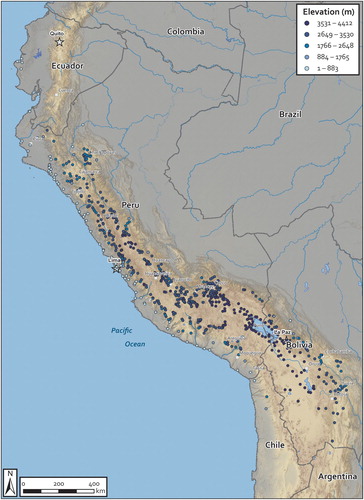
Turning to the settlement map of reducciones identified by LOGAR, visual assessment of their distribution suggests distinct coastal and highland networks of reducción towns (). The towns situated along the Pacific coast are generally situated at the distal end of the transverse valleys that cut through the hyperarid coastal plains as they descend to the Pacific. These coastal-lower Pacific valley reducciones appear to constitute a discrete settlement system apart from that of the highlands, which is separated by the steep scarps of the western cordillera. In the highlands, the largest concentration of reducciones are distributed through the mid to upper elevations in the intermontane valleys on both sides of the eastern and western cordilleras. In the central and north central highlands, these valleys are relatively steep and the eastern and western ranges are relatively close, while in the south the cordilleras diverge around Lake Titicaca, forming the broad, high altitude altiplano grasslands through much of highland Bolivia. The distribution of reducciones follows these trends, with an apparent concentration of towns in the central and south central highlands, and a more dispersed pattern in the altiplano.
Figure 1. Located reducciones (N = 673) by elevation.
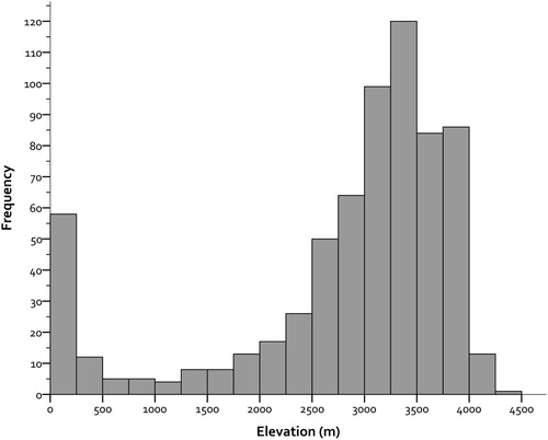
A histogram of reducción elevations () shows a bimodal distribution, with a group of towns along the coast and lower reaches of the transverse valleys (below 250 m) that descend to the Pacific, and a second, much larger peak of towns located in the highland valleys and altiplano between 2500 and 4000 meters above sea level, with a pronounced peak between 3000 and 3500 meters (), with a slight drop but continued high frequencies in the higher altitude areas, including in the puna grasslands up to 4000 m. This bulk of settlement between 3000 and 4000 meters reflects the distribution of the great highland agriculturalist and pastoralist populations of the central Andes, respectively. The frequency of reducciones then plummets above 4000 m, and none are higher than 4500 m, where permanent human settlement is sparse.
Figure 2. Histogram of reducciones (N = 673) by elevation.
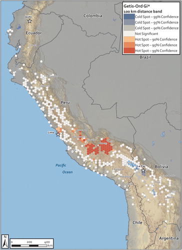
Looking more closely at the horizontal distribution of reducciones, there appear to be clusters of reducciones in the central Andes, particularly around the former capital of the Inka empire, Cuzco. Tests for the presence of statistically significant hot or cold spots of reducciones can be calculated by spatially binning reducciones by a polygon mesh (in this case, hexagons) and performing a Getis-Ord Gi* statistic on the reducción counts (Getis and Ord Citation1993). This test shows a significant hotspot of reducciones (at the .01 level) in the central and south-central highlands, with the largest concentration around Cuzco and neighboring Abancay, Ayacucho, Huancavelica, and Huancayo (). These clusters were robust to variations in bin size and distance band parameter combinations. Interestingly, the only other significant hotspot of reducciones surrounds Lima, where a large number of reducciones were built in the middle and upper reaches of the three major highland river valleys (Chillón, Rimac, and Lurín) that converge there.
Figure 3. Hotspot analysis (Getis-Ord Gi*) of reducciones.South America equidistant conic projection.
This first interregional scale view of the distribution of reducciones enables some preliminary characterizations and queries for future field and imagery-based research. In general, reducción densities map onto regional and inter-regional variations in population densities during terminal prehispanic times (although such variation in population densities at large scale are not well understood either). The clustering of reducciones in the central and south-central highlands, especially around Cuzco, is likely an emergent property of the large and relatively dense populations there, as well as the high productivity and diversity of the the central Andean highlands. It is a region with many small intermontane valleys, each having been transformed into highly productive production zones supporting many distinct ethnic polities (see Gade and Escobar Citation1982). Greater Cuzco was densely populated on the eve of the Spanish invasion, both by autochthonous peoples and by ethnic colonists, elite retainers, and other personnel resettled by the Inkas (Bauer Citation2004; Covey Citation2006; Covey, Childs, and Kippen Citation2011; Kosiba and Bauer Citation2012). As noted above, demographic data on these reducciones is registered in scattered and fragmentary colonial administrative documents, but they remain to be systematically compiled across the region. It is conceivable, though quite unlikely, that the reducciones that make up the hotspot clusters in Cuzco, Abancay, Ayacucho, Huancavelica, and Huancayo are systematically smaller than in other areas, resulting in more reducciones per unit area. Another possibility is that the Reducción was more comprehensive in this core administrative area (both during Inka and colonial times), incorporating a higher proportion of the population in the high altitude areas, for example, than in other areas. But it is more likely that the hotspot of reducciones in greater Cuzco echoes an earlier history of population concentration by the Inkas, linked to the a broader processes of constructing and consolidating an imperial heartland. Lima and its environs (the Rimac, Chillon and Lurin river valleys) also appears to have been a major demographic center during late prehispanic times. Headed by the coastal Yschma polity and serving as home to neighboring ethnic groups in the middle and upper reaches of coastal drainages, these drainages contained populations were especially large and dense (Díaz and Vallejo Citationn.d.; Rostworowski de Diez Canseco Citation1977). They also appear to have been significantly reshuffled, in large measure as a result of enormous investments by the Inkas in the pilgrimage center of Pachacamac (Lurín Valley), where they further elaborated the pyramid complex abode of the eponymous earth creator deity.
The discovery of these patterns illustrates the generative potential of interregional comparison. Of course, local and regional-scale analyses are essential for making sense of them, but absent interregional-scale distribution data, we were simply not aware that there were significant clusters of reducciones in Cuzco and the greater Lima area. The patterns observed in the reduccion distribution data raise new questions, particularly about the legacies of Inka imperial policies and other forces influencing terminal prehispanic demography. At a minimum, it seems clear that the towns created by the General Resettlement were not arbitrarily inserted in the landscape or distributed with an eye for maximum separation between them. Instead, they demonstrate path dependent adaptations to landesque capital.
We can further explore the legacies of Inka imperial policy on colonial population distribution by exploring the distribution of reducciones in relation to another material manifestation of Inka power: the royal highway network, or Qhapaq Ñan. The Proyecto Qhapaq Ñan (PQN), a large, multiyear special project of the Ministry of Culture, Peru, has mapped thousands of kilometers of the remnants of the Inka royal road system. This public domain dataset facilitates exploration and analysis of the relationship between the distributions of the reducciones and the Inka imperial road network. A view of the spatial relationships between reducciones and PQN roadways suggests (literal) path dependence between reduccion location and Inka imperial highways. If we return to the distribution of reducciones in , roughly linear arrangements are evident on either side of the intermontane valleys and the lower reaches of the Pacific drainages and coast. Visual inspection of the relationship () suggests that the distribution of the reducciones is markedly influenced by proximity to Inka thoroughfares, the great majority of which continued to be used as major roads through the colonial era.
Figure 4. Located reducciones in relation to Inka imperial highway segments
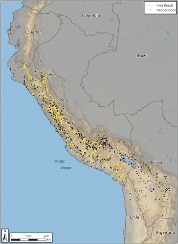
Spatial dependency of the distribution of reducciones in relation to the Inka imperial roads can be measured by comparing their proximity to the mapped road segments to the proximity of a null hypothesis (random) distribution of the same number of points in the same area. The ancient roads mapped by the Proyecto Qhapaq Ñan are within the national boundaries of the modern republic, which contains 560 reducciones. We used GIS-based proximity tools to measure the Euclidean distance between each reducción and the nearest vertex in the Qhapaq Ñan road polyline theme. We then compared these distances to proximity values for randomized distributions of 560 points. The bounding polygon for these randomized distributions was derived from the concave hull of the distribution of the reducciones, (using the k = 3 nearest neighbors input parameter) (Neumann Citation2017). Five randomization iterations were generated for proximity calculation relative to the Qhapaq Ñan roads and comparison with proximity measures of the actual reducción locations. The variance of the observed and null hypothesis proximity measures was significantly different, so Mann-Whitney U tests were used (rather than a t-test) to compare the observed and null hypothesis proximity measure distributions. In all five iterations, the Mann-Whitney test indicates that distances between the reducciones and Qhapaq Ñan roads were significantly less than those of the null hypothesis point distributions ().
Table 1. Mann-Whitney U Test for differences in distances (in meters) between reducciones and Inka imperial roads versus null hypothesis distributions of sites and Inka imperial roads.
This result provides an initial high level insight into one of the (many) determinants of the emplacement of reducciones in the landscapes of the central Andes. Viceregal authorities did not arbitrarily locate reducciones by administrative fiat; their emplacement was, at least in significant measure, literally path dependent in relation to the Inka imperial road system. In their Spanish administrators and Andean lords “read” the road system and repurposed it to mitigate community dislocations due to resettlement while also leveraging it for Spanish colonial economic extraction and exploitation.
Discussion and Conclusion
GeoPACHA and LOGAR are opening up interregional scale perspectives in Andean archaeology and ethnohistory that in practical terms are beyond the reach of field-based or conventional archival methodologies. The Reducción—a colossal project of colonial social engineering that dislocated Andean communities over an area spanning large areas of modern Ecuador, Peru, Bolivia, and Chile—is an example of the kind of interregional scale phenomenon that requires systematically-collected interregional scale data to understand its variable implementation and effects. LOGAR has facilitated toponymic matching of the towns listed in colonial administrative documents with modern counterparts to produce the most comprehensive map of towns built during the Reducción, with over three quarters of the towns listed in the surviving fragments of its summary ledger now located.
Here, we have begun to explore patterns in the horizontal and vertical distributions of reducciones in the Andean landscape, and their relationships to Inka imperial infrastructure. Distinct coastal and highland distributions of reducciones are evident, and clusters of reducciones in the greater Cuzco and Lima areas hint at how the reducciones mapped onto population distributions from the Inka imperial era. Exploration of the distribution of reducciones in relation to the Inka road system suggests how the infrastructure of one empire was incorporated and made legible to another. The settlement pattern of the Reducción was an emergent property of the political mandate for the imposition of compulsory urbanism, physio-geographic and ecological affordances, extant settlement patterns and infrastructure, and variable agendas and outcomes in asymmetrical political negotiations between colonial administrators and Andean communities. The kind of perspective made possible through these collaborative platforms on the resulting distribution of people during terminal prehispanic and early colonial times was lacking.
Of course, understanding the variable effects of these factors in different areas of the Andes requires contextual information beyond the scope of this analysis. As interregional scale analysis is just getting started in the Andes, we are mindful of the pitfalls of imposing top-down schema and ignoring inter-locality differences (thus, “seeing like a state”). Intensive, community-engaged field and archival research complement our perspective here, as each contextualizes the other. Nonetheless, the limits of traditional field- and archival-based research approaches are also evident enough, with their limited and patchy coverage, and bespoke, problem-specific projects.
With these initial insights, we see potential for improving the quality and granularity of the data in these collaborative platforms, but also their limitations. Future expansion of documentary sources (for example, post-toledan visitas) collated by place in LOGAR promises to improve our interregional vision of the settlement history of the colonial Andes. The ratio of located reducciones will improve with implementation of the GeoPACHA platform to locate relict reducciones (and other surficially-visible archaeological features) through systematic imagery-based prospection. Of course, there are hard limits on the kinds of questions that aerial imagery can help us answer. Virtual survey will never substitute for or replace field archaeology, but it holds the promise of extending the bounds of our vision, both spatially (by enabling interregional perspectives) and temporally (by enabling systematic detection of now-destroyed or degraded features, through the analysis of historic imagery). We see it as an additional layer of the research process, akin to the relationship between survey and excavation in field archaeology.
Delivering on the promise of virtual survey will require a critical eye for making sense of interregional scale data paired with deep knowledge of locality and region, including close engagements with communities and jurisdictions traversed by interregional AI-assisted projects. We see the relationship between imagery-based survey, AI-assisted survey, and field-based methodologies as complementary and additive. On the one hand, interregional perspectives of the scale achievable through imagery-based survey are (practically speaking) impossible to achieve in the field, given the exigencies and costs of fieldwork. Such a perspective can therefore reveal large scale distributional patterns (or at least hints about such patterns)—and by extension enable inference of past social processes—which would otherwise remain virtually unobservable.
Such a (literal) top-down, big picture perspective may seem to bias theoretical orientations isometrically—that is to say that large scale, top-down perspectives lend themselves to “seeing like a state.” But we see no a priori reason for such to be the case. Rather than simplifying or surpressing local variation, interregional views can enable detection of diversity in patterning that may be unobservable at smaller scales. In the case study presented here, significant inter-regional variation in the density of reducciones and their spatial dependence on extant Inka infrastructure point to dependencies of Spanish colonial administration on prior settlement patterns and infrastructure. A perspective of emergence rather than solely colonial domination and imposition begins to come into focus.
Such insights can then inform research designs for fieldwork. Reciprocally, field survey and excavation can act as a validation step through ground truthing, but equally importantly, can also enable observation at scales closer to past human experience and in closer engagement with descendent communities. In these senses, we share concerns about high modernist discourses concerning speed and efficiency of data acquisition and processing as ends in themselves in archaeological research (Caraher Citation2016; Cunningham and MacEachern Citation2016). This is not “fast science.” Indeed, we don’t think imagery based survey should or could displace (let alone replace) field survey at all—it is additive. But it can help frame research questions for regional survey and other “slow” field methodologies. In these senses, we might call the approach we advocate “slow, imagery and AI-assisted archaeology.”
In summary, our experience developing and implementing LOGAR and GeoPACHA has led us to see imagery survey and field archaeology as complementary and interdependent research methodologies. Clearly, the data revolution poses significant epistemological, methodological, and ethical challenges and hazards. But it also holds tremendous promise for constructing new understandings and knowledge about past human societies, while extending archaeology beyond the bounds of field-based research.
Acknowledgments
Initial development of LOGAR and GeoPACHA were supported by funding through a National Endowment for the Humanities Office of Digital Humanities Startup Grant, a Vanderbilt University Center for Digital Humanities Faculty Fellowship, and a Vanderbilt University Chancellor’s Faculty Fellowship (Wernke, P.I.). Implementation-scale funding for GeoPACHA is supported by a Digital Extension Grant from the American Council of Learned Societies (Wernke and VanValkenburgh, co-P.I.s), and a Spatial Archaeometry Research Collaborations (SPARC) grant from the Center for Advanced Spatial Technologies (CAST) at the University of Arkansas (Wernke and VanValkenburgh, Co-P.I.s). Imagery purchases were made possible by a grant from the Vanderbilt University Data Science Institute, and an in-kind grant from the DigitalGlobe Foundation (Wernke, P.I.). Computational infrastructural support was provided by the Spatial Analysis Research Laboratory, Vanderbilt University, and the Digital Archaeology Laboratory, Brown University. The ideas developed in this paper benefitted tremendously through the symposia and workshops made possible by the Japan Society for the Promotion of Science (Saito, P.I.). All errors in fact or interpretation are solely those of the authors.
Disclosure Statement
No potential conflict of interest was reported by the author(s).
Notes on Contributors
Steven Wernke (Ph.D. 2003, University of Wisconsin-Madison) is the Joe B. Wyatt Distinguished University Professor and Associate Professor of Anthropology, and director of the Spatial Analysis Research Laboratory (SARL) at Vanderbilt University. Currently, he directs two digital archaeology and ethnohistory initiatives focusing on prehispanic and colonial communities in the Andes: LOGAR: Linked Open Gazetteer of the Andean Region (with co-editor Akira Saito, National Museum of Ethnology, Japan), and GeoPACHA: Geospatial Platform for Andean History, Culture, and Archaeology (with co-editor Parker VanValkenburgh, Brown University).
Parker VanValkenburgh (Ph.D. 2012, Harvard University) is Assistant Professor of Anthropology at Brown University, head of the Brown Digital Archaeology Laboratory, and an elected fellow of the Institute at Brown for Environment and Society. Among other research projects, he co-directs the Paisajes Arqueológicos de Chachapoyas project with Carol Rojas Vega and is co-editor, with Steven Wernke, of GeoPACHA: Geospatial Platform for Andean History, Culture, and Archaeology.
Akira Saito (M.A. 1991, University of Tokyo) is Professor of Cultural Anthropology at the National Museum of Ethnology and the Graduate University for Advanced Studies (SOKENDAI), Japan. He is coeditor of Reducciones: la concentración forzada de las poblaciones indígenas en el Virreinato del Perú (PUCP, 2017). With funding from the Japan Society for the Promotion of Science, he currently directs the interdisciplinary research project Colonial Modernity in the Andes: A Comparative Study of Viceroy Toledo’s General Resettlement.
References
- Adams, R. M. 1981. Heartland of Cities: Surveys of Ancient Settlement and Land Use on the Central Floodplain of the Euphrates. Chicago: University of Chicago Press.
- Alexakis, D., A. Sarris, T. Astaras, and K. Albanakis. 2009. “Detection of Neolithic Settlements in Thessaly (Greece) Through Multispectral and Hyperspectral Satellite Imagery.” Sensors 9 (2): 1167–1187. doi: 10.3390/s90201167
- Algaze, G. 1993. The Uruk World System: The Dynamics of Expansion of Early Mesopotamian Civilization. Chicago: University of Chicago Press.
- Averett, E. W., J. M. Gordon, and D. B. Counts. 2016. Mobilizing the Past for a Digital Future: The Potential of Digital Archaeology. Grand Forks, North Dakota: The Digital Press at The University of North Dakota.
- Barker, G., D. Gilbertson, B. Jones, and D. Mattingly. 1996a. Farming the Desert: The UNESCO Libyan Valleys Archaeological Survey II: Site Gazetteer and Pottery. Paris: UNESCO, Society for Libyan Studies, and London: Society for Libyan Studies.
- Barker, G., D. Gilbertson, B. Jones, and D. Mattingly. 1996b. Farming the Desert: The UNESCO Libyan Valleys Archaeological Survey. Volume One: Synthesis: 1. Illustrated edition edition. Paris: Tripoli : London: UNESCO.
- Bauer, B. S. 2004. Ancient Cuzco; Heartland of the Inca. Austin: University of Texas.
- Bauer, B. S., and R. A. Covey. 2002. “Processes of State Formation in the Inca Heartland (Cuzco, Peru).” American Anthropologist 104 (3): 846–864. doi: 10.1525/aa.2002.104.3.846
- Blanton, R., G. M. Feinman, S. A. Kowalewski, and L. M. Nicholas. 1999. Ancient Oaxaca. Cambridge: Cambridge University Press.
- Blanton, R., S. Kowalewski, G. Feinman, and J. Appel. 1981. Ancient Mesoamerica: A Comparison of Change in Three Regions. Cambridge: Cambridge University Press.
- Blaschke, T. 2010. “Object Based Image Analysis for Remote Sensing.” ISPRS Journal of Photogrammetry and Remote Sensing 65 (1): 2–16. doi: 10.1016/j.isprsjprs.2009.06.004
- Blaschke, T., G. J. Hay, M. Kelly, S. Lang, P. Hofmann, E. Addink, R. Q. Feitosa, F. van der Meer, H. van der Werff, and F. van Coillie. 2014. “Geographic Object-Based Image Analysis–Towards a New Paradigm.” ISPRS Journal of Photogrammetry and Remote Sensing 87: 180–191. doi: 10.1016/j.isprsjprs.2013.09.014
- Caraher, W. R. 2016. “Slow Archaeology:Technology, Efficiency, and Archaeological Work.” In Mobilizing the Past for a Digital Future: The Potential of Digital Archaeology, edited by E. W. Averett, J. M. Gordon, and D. B. Counts, 421–441. Grand Forks, North Dakota: The Digital Press @ The University of North Dakota.
- Casana, J. 2014. “Regional-Scale Archaeological Remote Sensing in the Age of Big Data: Automated Site Discovery vs. Brute Force Methods.” Advances in Archaeological Practice: 222–233. doi: 10.7183/2326-3768.2.3.222
- Casana, J., and J. Cothren. 2013. “The CORONA Atlas Project: Orthorectification of CORONA Satellite Imagery and Regional-Scale Archaeological Exploration in the Near East.” In Mapping Archaeological Landscapes from Space, edited by D. C. Comer and M. J. Harrower, 33–43. New York: Springer.
- Casey, E. S. 1996. “How to Get from Space to Place in a Fairly Short Stretch of Time: Phenomenological Prolegomena.” In Senses of Place, edited by S. Feld and K. H. Basso, 13–52. Santa Fe: School of American Research.
- Chase-Dunn, C. K., and T. D. Hall. 1991. Core/Periphery Relations in Precapitalist Worlds. Boulder, CO: Westview Press.
- Covey, R. A. 2006. How the Incas Built Their Heartland: State Formation and the Innovation of Imperial Strategies in the Sacred Valley, Peru. History, Languages, and Cultures of the Spanish and Portuguese Worlds. Ann Arbor: University of Michigan Press.
- Covey, R. A., G. Childs, and R. Kippen. 2011. “Dynamics of Indigenous Demographic Fluctuations: Lessons from Sixteenth-Century Cusco, Peru.” Current Anthropology 52 (3): 335–360. doi: 10.1086/660010
- Cresswell, T. 2014. Place: An Introduction. New York: John Wiley & Sons.
- Cummins, T. 2002. “Forms of Andean Colonial Towns, Free Will, and Marriage.” In The Archaeology of Colonialism, edited by C. L. Lyons and J. K. Papadopoulos, 199–240. Los Angeles: Getty Research Institute.
- Cunningham, J. J., and S. MacEachern. 2016. “Ethnoarchaeology as Slow Science.” World Archaeology 48 (5): 628–641. doi: 10.1080/00438243.2016.1260046
- Daniels, C. 1970. The Garamantes of Southern Libya. London: Oleander.
- De Laet, V., E. Paulissen, and M. Waelkens. 2007. “Methods for the Extraction of Archaeological Features from Very High-Resolution Ikonos-2 Remote Sensing Imagery, Hisar (Southwest Turkey).” Journal of Archaeological Science 34 (5): 830–841. doi: 10.1016/j.jas.2006.09.013
- Deng, J., W. Dong, R. Socher, L.-J. Li, K. Li, and L. Fei-Fei. 2009. “Imagenet: A Large-Scale Hierarchical Image Database.” In Computer Vision and Pattern Recognition, 2009. CVPR 2009. IEEE Conference On, 248–255. IEEE.
- Díaz, L., and F. Vallejo. n.d. “Variaciones Culturales En El Valle de Lima Durante La Ocupación Incaica.” Chungará (Arica) 36: 295–302.
- Durston, A. 1999. “El Processo Reduccional En El Sur Andino: Confrontación y Síntesis de Sistemas Espaciales.” Revista de Historia Indígena 4: 75–101.
- Gade, D., and M. Escobar. 1982. “Village Settlement and the Colonial Legacy in Southern Peru.” Geographical Review 72 (4): 430–449. doi: 10.2307/214595
- Garrison, T. G., S. D. Houston, C. Golden, T. Inomata, Z. Nelson, and J. Munson. 2008. “Evaluating the Use of IKONOS Satellite Imagery in Lowland Maya Settlement Archaeology.” Journal of Archaeological Science 35 (10): 2770–2777. doi: 10.1016/j.jas.2008.05.003
- Getis, A., and J. Ord. 1993. “The Analysis of Spatial Association by Use of Distance Statistics.” Geographical Analysis 25 (3): 276–276.
- Gillies, S., and T. Elliott. 2015. “Ancient Places in Pleiades.” https://pleiades.stoa.org/places.
- Goodfellow, I., Y. Bengio, and A. Courville. 2016. Deep Learning. Cambridge, Massachusetts: MIT Press.
- Hanks, W. F. 2010. Converting Words : Maya in the Age of the Cross. The Anthropology of Christianity 6. Berkeley: University of California Press.
- Harrower, M. J., J. Schuetter, J. McCorriston, P. K. Goel, and M. J. Senn. 2013. “Survey, Automated Detection, and Spatial Distribution Analysis of Cairn Tombs in Ancient Southern Arabia.” In Mapping Archaeological Landscapes from Space, edited by D. C. Comer and M. J. Harrower, 259–268. New York: Springer.
- Heckenberger, M. J., J. C. Russell, C. Fausto, J. R. Toney, M. J. Schmidt, E. Pereira, B. Franchetto, and A. Kuikuro. 2008. “Pre-Columbian Urbanism, Anthropogenic Landscapes, and the Future of the Amazon.” Science 321 (5893): 1214–1217. doi: 10.1126/science.1159769
- Hemming, J. 1983. The Conquest of the Incas. New York: Penguin Books.
- Jennings, J. 2014. Globalizations and the Ancient World. New York: Cambridge University Press.
- Kosiba, S., and A. M. Bauer. 2012. “Mapping the Political Landscape: Toward a GIS Analysis of Environmental and Social Difference.” Journal of Archaeological Method and Theory 14 (1): 61–101. doi: 10.1007/s10816-011-9126-z
- Krizhevsky, A., I. Sutskever, and G. E. Hinton. 2012. “Imagenet Classification with Deep Convolutional Neural Networks.” In Advances in Neural Information Processing Systems, edited by F. Pereira, C. J. C. Burges, L. Bottou, and K. Q. Eeinberger, 1097–1105.
- Málaga Medina, A. 1975. “Las Reducciones En El Virreinato Del Perú (1532–1580).” Revista de Historia de América 80: 8–45.
- Mattingly, D. J. 2004. “Surveying the Desert: From the Libyan Valleys to Saharan Oases.” British School at Athens Studies 11: 163–176.
- McMichael, C. H., M. W. Palace, M. B. Bush, B. Braswell, S. Hagen, E. G. Neves, M. R. Silman, E. K. Tamanaha, and C. Czarnecki. 2014. “Predicting Pre-Columbian Anthropogenic Soils in Amazonia.” Proceedings of the Royal Society of London B: Biological Sciences 281 (1777): 1–9. doi: 10.1098/rspb.2013.2475
- Menze, Bjoern H., and J. A. Ur. 2012. “Mapping Patterns of Long-Term Settlement in Northern Mesopotamia at a Large Scale.” Proceedings of the National Academy of Sciences 109 (14): E778–87. doi: 10.1073/pnas.1115472109
- Menze, Björn H., J. A. Ur, and A. G. Sherratt. 2006. “Detection of Ancient Settlement Mounds.” Photogrammetric Engineering & Remote Sensing 72 (3): 321–327. doi: 10.14358/PERS.72.3.321
- Mohler, G. O., M. B. Short, S. Malinowski, M. Johnson, G. E. Tita, A. L. Bertozzi, and P. J. Brantingham. 2015. “Randomized Controlled Field Trials of Predictive Policing.” Journal of the American Statistical Association 110 (512): 1399–1411. doi: 10.1080/01621459.2015.1077710
- Mumford, J. R. 2012. Vertical Empire: The General Resettlement of Indians in the Colonial Andes. Durham, NC: Duke University Press.
- Neumann, D. 2017. QGIS-Concave Hull Plugin. https://github.com/detlevn/QGIS-ConcaveHull-Plugin.
- Parcak, S. 2019. Archaeology from Space: How the Future Shapes Our Past. 1st Edition edition. New York: Henry Holt and Co.
- Parcak, S. H. 2009. Satellite Remote Sensing for Archaeology. New York: Routledge.
- Pease, F. 1989. Del Tawantinsuyu a La Historia Del Peru. Lima: Pontificia Universidad Católica del Perú.
- Rostworowski de Diez Canseco, M. 1977. “Breve Ensayo Sobre El Senorío de Ychma.” In Etnia y Sociedad. Costa Peruana Prehispánica, edited by M. Rostworowski de Diez Canseco, 197–210. Lima: Instituto de Estudios Peruanos.
- Russakovsky, O., J. Deng, H. Su, J. Krause, S. Satheesh, S. Ma, Z. Huang, A. Karpathy, A. Khosla, and M. Bernstein. 2015. “Imagenet Large Scale Visual Recognition Challenge.” International Journal of Computer Vision 115 (3): 211–252. doi: 10.1007/s11263-015-0816-y
- Saito, A., and C. Rosas Lauro. 2017. Reducciones. La Concentración Forzada de Las Poblaciones Indígenas En El Virreintao Del Perú. Lima: Pontificia Universidad Catolica del Peru, Fondo Editorial.
- Sanders, W. T. 1970. The Teotihuacan Valley Project Final Report. Vol. 1. Dept. of Anthropology, Pennsylvania State University.
- Saturno, W., T. L. Sever, D. E. Irwin, B. F. Howell, and T. G. Garrison. 2006. “Putting Us on the Map: Remote Sensing Investigation of the Ancient Maya Landscape.” In Remote Sensing in Archaeology, edited by J. R. Wiseman and F. El-Baz, 137–160. New York: Springer.
- Schuetter, J., P. Goel, J. McCorriston, J. Park, M. Senn, and M. Harrower. 2013. “Autodetection of Ancient Arabian Tombs in High-Resolution Satellite Imagery.” International Journal of Remote Sensing 34 (19): 6611–6635. doi: 10.1080/01431161.2013.802054
- Scott, J. C. 1998. Seeing Like a State: How Certain Schemes to Improve the Human Condition Have Failed. New Haven: Yale University Press. Book review (H-Net).
- Sempat Assadourian, C. 1983. El Sistema de La Economía Colonial: Mercado Interior, Regiones, y Espacio Económico. México: Editorial Nueva Imagen.
- Smith, M. L. 2005. “Networks, Territories, and the Cartography of Ancient States.” Annals of the Association of American Geographers 95 (4): 832–849. doi: 10.1111/j.1467-8306.2005.00489.x
- Smith, M. L. 2007. “Territories, Corridors, and Networks: A Biological Model for the Premodern State.” Complexity 12 (4): 28–35. doi: 10.1002/cplx.20173
- Spalding, K. 1982. “Exploitation as an Economic System: The State and the Extraction of Surplus in Colonial Peru.” In The Inca and Aztec States, 1400-1800: Anthropology and History, edited by G. A. Collier, R. Rosaldo, and J. D. Wirth, 321–342. New York: Academic Press.
- Stern, S. J. 1982. Peru’s Indian Peoples and the Challenge of Spanish Conquest. Madison, WI: University of Wisconsin Press.
- Tansey, K., I. Chambers, A. Anstee, A. Denniss, and A. Lamb. 2009. “Object-Oriented Classification of Very High Resolution Airborne Imagery for the Extraction of Hedgerows and Field Margin Cover in Agricultural Areas.” Applied Geography 29 (2): 145–157. doi: 10.1016/j.apgeog.2008.08.004
- Toledo, F. de. 1921. “Carta Del Virrey D. Francisco de Toledo a Su Magestad Sobre Materias Tocantes al Buen Gobierno y Justicia de Las Provincias Del Perú, Los Reyes, 8 Febrero de 1570.” In Gobernantes Del Perú: Cartas y Papeles Siglo XVI, Documentos Archivo de Indias, edited by R. Levillier. Vol. III. Colección de Publicaciones Históricas de La Biblioteca Del Congreso Argentino. Madrid: Sucesores de Rivadeneyra.
- Trier, ØD, D. C. Cowley, and A. U. Waldeland. 2019. “Using Deep Neural Networks on Airborne Laser Scanning Data: Results from a Case Study of Semi-Automatic Mapping of Archaeological Topography on Arran, Scotland.” Archaeological Prospection 26 (2): 165–175. doi: 10.1002/arp.1731
- Trier, ØD, SØ Larsen, and R. Solberg. 2009. “Automatic Detection of Circular Structures in High-Resolution Satellite Images of Agricultural Land.” Archaeological Prospection 16 (1): 1–15. doi: 10.1002/arp.339
- Tuan, Y. 1977. Space and Place: The Perspective of Experience. Minneapolis: University of Minnesota Press.
- Ur, J. A. 2003. “CORONA Satellite Photography and Ancient Road Networks: A Northern Mesopotamian Case Study.” Antiquity 77 (295): 102–115. doi: 10.1017/S0003598X00061391
- Ur, J. A. 2006. “Google Earth and Archaeology.” The SAA Archaeological Record 6 (3): 35–38.
- Ur, J. A. 2010. Tell Hamoukar, Volume 1. Urbanism and Cultural Landscapes in Northeastern Syria: The Tell Hamoukar Survey, 1999–2001. Chicago: Oriental Institute of the University of Chicago.
- VanValkenburgh, P. 2016. “Historias Galonadas: La Genealogía de Reducción, Paisaje y Población En Los Valles de Zaña y Chamán, Perú.” In Reducciones: La Concentración Forzada de Las Poblaciones Indígenas En El Virreinato Del Perú, edited by A. Saito and C. Rosas Lauro, 223–260. Lima: Pontificia Universidad Católica del Perú.
- VanValkenburgh, P. 2017. “Unsettling Time: Persistence and Memory in Spanish Colonial Peru.” Journal of Archaeological Method and Theory 24 (1): 117–148. doi: 10.1007/s10816-017-9321-7
- VanValkenburgh, P., C. P. Walker, and J. O. Sturm. 2015. “Gradiometer and Ground-Penetrating Radar Survey of Two Reducción Settlements in the Zaña Valley, Peru.” Archaeological Prospection 22 (2): 117–129. doi: 10.1002/arp.1499
- Wallace, C. A. B. 2017. “Retrospective Photogrammetry in Greek Archaeology.” Studies in Digital Heritage 1 (2): 607–626. doi: 10.14434/sdh.v1i2.23251
- Wernke, S. A. 2007a. “Analogy or Erasure? Dialectics of Religious Transformation in the Early Doctrinas of the Colca Valley, Peru.” International Journal of Historical Archaeology 11 (2): 152–182. doi: 10.1007/s10761-007-0027-5
- Wernke, S. A. 2007b. “Negotiating Community and Landscape in the Peruvian Andes: A Transconquest View.” American Anthropologist 109 (1): 130–152. doi: 10.1525/aa.2007.109.1.130
- Wernke, S. A. 2013. Negotiated Settlements: Andean Communities and Landscapes under Inka and Spanish Colonialism. Gainesville, FL: University Press of Florida.
- Wernke, S. A., and A. Saito, eds. 2019. LOGAR: Linked Open Gazetteer of the Andean Region.
- Wilkinson, K. N., A. R. Beck, and G. Philip. 2006. “Satellite Imagery as a Resource in the Prospection for Archaeological Sites in Central Syria.” Geoarchaeology 21 (7): 735–750. doi: 10.1002/gea.20136
- Zuloaga Rada, M. 2012. La Conquista Negociada: Guarangas, Autoridades Locales e Imperios En Huaylas, Perú (1532–1610). Lima: Instituto de Estudios Peruanos and Instituto Francés de Estudios Andinos.
- Zuloaga Rada, M. 2016. “Las Reducciones: Su Proyecto, Su Aplicación y Su Evolución.” In Reducciones: La Concentración Forzada de Las Poblaciones Indígenas En El Virreinato Del Perú, edited by A. Saito and C. Rosas Lauro, 307–346. Lima: Pontificia Universidad Católica del Perú.