
ABSTRACT
The Middle East and North Africa have witnessed a surfeit of geospatial data collection projects, resulting in big databases with powerful deductive capacities. Despite the valuable insights and expansive evidentiary record offered by those databases, emphasis on anthropogenic threats to cultural heritage, combined with a limited integration of local perspectives, have raised important questions on the ethical and epistemological dimensions of big data. This paper contextualizes maritime cultural heritage (MCH) in those debates through the lens of the Maritime Endangered Archaeology in the Middle East and North Africa project (MarEA). MarEA is developing a unique for the region database for MCH designed to amalgamate a baseline record emphasizing spatial location, state of preservation, and vulnerability. This record will form a stepping stone toward finer-grained research on MCH and its interdisciplinary intersections. It is also developed as an information resource to facilitate local collaborators in prioritizing site monitoring and developing documentation, management, and mitigation strategies.
Introduction
“Big data” is a term increasingly used since the 1990s to describe large volumes of data managed and processed through IT architecture. Due to their volume, big data are considered to have a higher resulting performance and variety, as demonstrated in information technologies and corporate environments (Tang Citation2016). Widely used to inform decision-making and forecasting in business analysis, marketing, transportation, and, increasingly, environmental monitoring (e.g., Gorelick et al. Citation2017), the emergence of big data in archaeological practice in the past decade has been slower and received with both enthusiasm and skepticism (Kitchin Citation2014; Gattiglia Citation2015; Green Citation2020; Journal of Field Archaeology 45, S1).
In a recent special issue in the Journal of Field Archaeology, VanValkenburgh and Dufton (Citation2020) offer a thoughtful definition of big data, with emphasis on the adjective “big” used not solely to refer to the scale or dimension of data, but primarily to the extensive possibilities they afford for archaeological analysis. Contributions to that issue generally agree that big data have changed the scope of archaeological research, aiming for complete datasets and accelerating research output. Ongoing conversations on big data in archaeology tend to discuss geospatial technological and methodological advances (satellite and airborne remote sensing and machine learning) that have opened the way for data collection beyond the scale of regional surveys and have enabled more nuanced interregional perspectives. The ensuing collection of unprecedented amounts of data has led to critical questions surrounding the meaning, quality, and ethics in the remote collection and analysis of archaeological information (Fisher et al. Citation2021).
The Middle East and North Africa (MENA) region, an area with a longstanding presence in historical and archaeological discourse, has been at the forefront of analyses relying on remotely-sensed big data. Originally collected with the aim to rapidly and remotely monitor inaccessible archaeological sites, geospatial approaches in the MENA region have developed into a theoretically-encompassing sub-discipline (Lawrence, Altaweel, and Philip Citation2020). The MENA region also offers a rapidly evolving methodological scope for the development of automated detection of sites (Casana Citation2014; Liss, Howland, and Levy Citation2017; Soroush et al. Citation2020), features (Brady, Howland, and Levy Citation2017; Orengo et al. Citation2020), and even potsherds (Orengo and Garcia-Molsosa Citation2019).
The proliferation of these methodologies in archaeological practice has resulted in an expansive corpus of cultural heritage databases (discussed below). The data captured vary according to intended use, ranging from gazetteers of archaeological sites to databases that register threats impacting the archaeological record. In the latter, there is an apparent propensity to document threats relating to conflict and looting—a recent example being Nagorno Karabakh in Armenia (Khatchadourian, Lindsay, and Smith Citation2021). Less attention has been placed on producing databases that detail the impact of non-anthropogenic factors on cultural heritage in the MENA region, notably climate change. The benefits of such databases are obvious, especially to local communities, who will experience, and have to respond to, the detrimental impacts of climate change (Stahl Citation2020). In addition, disproportionately little attention has been placed on the large-scale documentation of maritime (underwater, nearshore, and coastal) cultural heritage, even though the Mediterranean Sea, the Red Sea, the Persian Gulf, and the Arabian Sea figure conspicuously in major archaeological narratives from hominin migration to contemporary archaeology. Even though maritime cultural heritage (MCH) is equally, if not more, impacted by anthropogenic factors and more actively exposed to natural processes (Bennett et al. Citation2004; Galili and Rosen Citation2010; Pourkerman et al. Citation2018; Reimann et al. Citation2018; Brooks et al. Citation2020; Trakadas Citation2020), it has been integrated to a lesser extent in ongoing discourses on endangered archaeology in the MENA region (e.g., Galili, Oron, and Cvikel Citation2018).
This paper examines the challenges and prospects of big data approaches in maritime archaeology through the lens of the Maritime Endangered Archaeology of the Middle East and North Africa project (MarEA), a 5-year project focusing on the collection of archaeological and environmental information on vulnerable maritime archaeological sites in the MENA region () (Andreou et al. Citation2020). Within this research scope, we use the broad definition of maritime archaeology as evidence for pre-modern human engagement with the sea (exemplified by Westerdahl Citation1992; Atkinson and Hale Citation2012; Ransley et al. Citation2013), instead of more restrictive classifications, such as underwater or nautical archaeology. The evidence base, thus, can be found both on land and underwater (submerged) and could include anything from small objects to large vessels and structures, such as harbors.
Figure 1. Map of the MENA region (produced on ArcGIS Pro using bathymetric data from the General Bathymetric Chart of the Oceans, www.gebco.net).

We will first discuss the role and use of big data with respect to the archaeology of the MENA region, followed by some thoughts on associated ontological and epistemological challenges. Next, we will explore the ethical dimensions of collecting and managing data outside of their geographical origin. We subsequently expound on challenges particular to maritime archaeology, followed by a presentation of our data collection, documentation practices, in-country partnerships, and a demonstrative example of the applied use of the database in the context of disaster response.
Big Data and the Archaeology of the MENA Region
Geospatial approaches have offered unparalleled insights into archaeological landscapes in the MENA region (Hammer and Ur Citation2019; Casana Citation2020), including documentation and monitoring of places exposed to damage and destruction, as well as locales with limited access by archaeologists. It is unsurprising then that an abundance of remote geospatial projects in this region have laid important theoretical and methodological groundwork for the documentation of endangered sites (e.g., Casana and Laugier Citation2017; Rayne et al. Citation2017, Citation2020). Aerial and satellite imagery, most notably declassified Corona imagery, has made a particularly important contribution, long serving as a baseline for archaeology in the Middle East. At a smaller scale, archaeologists have used satellite imagery and aerial photography to enhance the spatial characteristics of known features and sites (Parcak Citation2007; Hammer Citation2019) and to document and monitor site destruction (Casana and Laugier Citation2017; Fradley and Sheldrick Citation2017; Rayne et al. Citation2017). At a broader scale, site documentation has also been conducted using automated classification (Ur Citation2013; Casana Citation2014; Soroush et al. Citation2020), offering promising results.
The above methodological developments resulted in the production of geographical and archaeological datasets, including the Corona Atlas of the Middle East (Casana and Cothren Citation2013), the Aerial Photographic Archive for Archaeology in the Middle East (APAAME) (Bewley et al. Citation2010), the Digital Archaeological Atlas of the Holy Land (DAAHL) (Savage and Levy Citation2014), the database of the Endangered Archaeology of the Middle East and North Africa (EAMENA) (Bewley et al. Citation2016), the MEGA-Jordan (Drzewiecki and Arinat Citation2017), DocArtis (www.docartis.com) and a national database (www.inp.tn/cnsa) for Tunisia, and a heritage gazetteer (www.slsgazetteer.org) for Libya. Many such datasets focus on documenting what has been identified as looting (summary in Kersel and Hill Citation2020), the remote identification of which is well-established in Afghanistan (Franklin and Hammer Citation2018), Egypt (Parcak Citation2015), Iraq (Hritz Citation2008; Hanson Citation2012), Jordan (Contreras and Brodie Citation2010), and Syria (Casana and Panahipour Citation2014; Cunliffe Citation2014; Tapete, Cigna, and Donoghue Citation2016). Meanwhile, equally pressing and detrimental factors, including demographic pressures and climate change, tend to be less visible in existing big archaeological datasets, though attempts are underway to address some of those issues (Rayne et al. Citation2020; Westley et al. Citation2021).
Increasing conversations about the use and analysis of, and infrastructure development for, big data in archaeology urges us to think about the impact of large datasets on data collection and narrative production. The epistemological advancements associated with geospatial big data inevitably come with empirical, conceptual, and ethical limitations, with associated challenges including sample bias toward larger, better discernible features, as well as questions surrounding the intellectual ownership of remotely produced or amalgamated geographical and archaeological data.
Ontological Challenges
An important benefit of big data is the unprecedented analytical capacity afforded by the use of standardized data classification, such as the Comité International pour la Documentation de l'ICOM Conceptual Reference Model (CIDOC CRM) standard ontological model for cultural heritage (Crofts et al. Citation2008), which facilitates comparative studies and understanding of broader patterns. Big data also allow a more effective organization, communication, and retrieval of information. Depending on the ontologies used in each database, they can enable different combinations of information, including data previously embedded in catalogues or archives with more limited capacities for access and analysis. In the context of archaeology, big datasets participating in linked open data (Candela et al. Citation2018) allow researchers to produce archaeological assemblages that are not limited by political, geographical, or contextual boundaries.
To take advantage of this, hosting projects or institutions require experts with diverse specializations and a constant upgrade of technological systems and infrastructure. Moreover, investment in time and expertise on issues surrounding data interoperability are necessary to facilitate information extraction (Vlachidis and Tudhope Citation2015), data discovery and accessibility (e.g., ARIADNE—Meghini et al. Citation2017), and conceptual referencing among different regions (Binding and Tudhope Citation2016; Henninger Citation2017).
Reasonable critique has arisen on the use of rigid categorizations (e.g., Gupta, Blair, and Nicholas Citation2020), particularly when observations are characterized by qualitative aspects. For example, during data collection via satellite imagery analysis, researchers will use their distinct knowledge, training, and field experience to identify and interpret visible anomalies, potentially without being able to conduct exhaustive research on the ontological dimensions of applied terminology. Critical discussions are also directed at the proliferation of data classifications that do not engage with indigenous ontologies and alternative understandings of cultural heritage. We explore this issue in a section below.
Overall, while the use of big data combined with consistent terminology allow for transregional analyses (McCoy Citation2020) and enable data integration of diverse archaeological assemblages, terminological standardization can mask local and regional variations. Those variations, however, are better targeted through a finer-grained examination. This can be facilitated in terms of time and financial investment, when informed by patterns highlighted though the analysis of satellite-derived big data. On the south-central coast of Cyprus, for example, large-scale documentation of erosion produced a vulnerability model that highlighted archaeological landscapes experiencing aggravated land loss (Andreou Citation2018). A finer-grained examination directed by the model output and in situ visits has documented eroding and newly-exposed remains (Andreou et al. Citation2019). Once we move beyond the misguided expectation that big data consist of complete datasets, it is possible to identify ways to maximize their potential, even in challenging contexts.
Epistemological Challenges
Though often viewed as a new epistemological paradigm (Kitchin Citation2014), the implications of big data in archaeology have raised concerns (Huggett Citation2020), particularly the widespread misconception that large amounts of data equal higher precision or improved interpretations. Critique has focused on surmises regarding the validity, deductive capacity, and credibility of analyses resulting from big data (e.g., Lohr Citation2015; McCoy Citation2017). In turn, the increase in the number of identified archaeological sites has created the need for robust quality control strategies and enhancement of metadata standards detailing the methodologies used for site identification (McCoy Citation2017, Citation2020; Opitz and Herrmann Citation2018). When it comes to the remote collection of large-scale archaeological datasets, three types of approaches are widely used, each with its epistemological challenges.
The first approach is expert-led site identification, as used by the Oriental Institute and the EAMENA project. Casana (Citation2014, 222) used the term “brute force” to refer to teams of specialized researchers that scan images and tag features. This approach is considered to provide archaeological observations that are as informed and accurate as possible (Casana Citation2014), the effectiveness of which has been demonstrated via ground verification for site identification and minimized inter-observer variability (Casana Citation2020). MarEA has adopted this approach and supports a central research team conducting initial imagery-based site identification, combined with bibliographic research and geographical observations which can be followed up by in-country surveys as effective means of quality control.
A second approach focuses on crowdsourcing data generated by untrained eyes. Perhaps the most known and controversial case is GlobalXplorero, an online platform that trains non-specialists to identify sites and presumed looting from satellite imagery (Parcak Citation2019). Beyond the ethical shortcomings of such approaches (discussed in the following section), the production of a large database by non-experts and without a clearly stated quality control strategy has raised concerns on the unregulated production of thousands of false positives, which can only be minimized via field-based observations (Casana Citation2020; McCoy Citation2020). Without concrete quality control measures, crowdsourced big archaeological datasets suffer from important epistemological limitations.
A third approach is automated feature detection informed by training data collected and cross-examined by experts. Depending on the quantity and quality of that data, inherent biases in the training sample will be reproduced in the automated detection process (Hoffman Citation2018; Ringer and Loschky Citation2018). As such, appropriate training and supervision are required to control those biases, as well as to identify the impact of potential inter-observer variability. It is important to note, however, that the size of the resulting data is one of the key limitations that prevents its systematic quality control (Savage, Johnson, and Levy Citation2017; Casana Citation2020, S95; and, more broadly, Woodall et al. Citation2014). Reasonable questions have been raised on how quality control can be undertaken, particularly when archaeological publications do not offer exhaustive documentation of their digital data collection and classification strategies (Caraher Citation2016), to the extent that some have argued that digital and/or remote collection and analysis methodologies are often not understood in satisfactory depth by their users (Kvamme Citation2018, 75). In other words, large amounts of data combined with limited understanding of the collection methodologies, and with an under-theorized approach to heritage, likely enable less critically-examined narratives.
Overall, even though automated approaches are considered by some to be the way forward (Orengo et al. Citation2020), systematic, intensive, and detailed expert-led analysis of satellite imagery, combined with bibliographic research and field-based observations by local collaborators, undeniably offers more nuanced and contextualized understandings of complex archaeological landscapes. Though resulting in relatively smaller volumes of data, brute force facilitates the collection of more accurate data and less dubious results. A combination of brute force and automated approaches presents important potential in the maximization of the deductive capacity of big data, particularly when brute force-derived data are used as training samples for automated approaches.
Ethical Considerations
The establishment of large databases in the MENA region has fostered conversations on the ethics and politics of globalized archaeological databases. Beyond important discussions on the ethics of digital archaeology (Dennis Citation2020), concerns pertain to the remote collection, management, and distribution of big data (VanValkenburgh and Dufton Citation2020). When projects derive data from formerly colonized countries and/or locations devastated by war or administered with limited resources, postcolonial critique has turned the discussion toward the imbalanced relations between those who collect and analyze data (experts) and those who live in the geographic areas from where the data originate. Particularly, the globalization of data relevant to the Global South through storing, management, and curation outside of their geographic origin is reminiscent of critiqued colonial practices (e.g., Azoulay Citation2019; Hicks Citation2020). With the MENA region at the forefront of conversations on postcolonial critique and archaeological ethics (Meskell Citation2020b), this section will discuss the issues most pertinent to the MarEA project. These include the use of remote sensing technologies to collect data and the use of data classification systems, both well-established methodologies in archaeological research and both with a long colonial legacy in the MENA region.
Many have discussed the panoptic view afforded by aerial imagery through its problematic historical links to colonialism and military surveillance (Hamilakis Citation2009; Pollock Citation2016; Pollock and Bernbeck Citation2018; Meskell Citation2020b), while others contrast remotely-sensed data with the valuable, yet often marginalized, proximate knowledge of local communities (McAnany and Rowe Citation2015; Mickel Citation2020). Fisher and colleagues (Citation2021) also remind us that remote sensing offers overseas researchers access to geographical data, the collection of which traditionally required site visits and permits from local authorities. Those permits are tied to local antiquities laws that often developed as a response to the exportation of antiquities to Western countries (Goode Citation2007). In other words, freely-available satellite imagery has enabled researchers to bypass in-country oversight to collect data and document human practices (e.g., landscape alterations) without the informed consent of people living in those areas (Pollock and Bernbeck Citation2018; Meskell Citation2020b, 220–221). We consider that a mutual understanding of the benefits of remote sensing in monitoring archaeological sites can be fostered through the collaborative collection or production of information with local heritage practitioners that have a more contextual understanding of associated challenges.
It is also important to consider who the beneficiaries of big datasets are, given that their archaeological contents are rarely entirely open access due to concerns that they may enable illicit excavations (Parcak Citation2007; Fernandez-Diaz et al. Citation2018). This issue becomes more acute because questions of data ownership and legality, especially when data is derived from freely-available imagery (Myers Citation2010a, Citation2010b; Scassa Citation2017), are an understudied topic in archaeology. In this context, the theoretical dimensions of big data have received less attention compared to the methodological and technological capacity of big databases.
Similarly, while acknowledging the advantages of digital documentation, some have voiced concern in the use of methods that are accessible mainly to those trained or living outside of the MENA region (Rico Citation2017a; Meskell Citation2018, 59–89; Stobiecka Citation2020). Rico (Citation2017b, 742) highlighted potential power imbalances sustained between heritage experts and local communities, including local archaeology practitioners. Others have critiqued the under-theorized approaches of digital archaeology (Dallas Citation2015; Huggett Citation2015; Huvila and Huggett Citation2018; Dennis Citation2020), as well as the lack of ethical and historical reflection in digital heritage practices (Meskell Citation2020a; Stobiecka Citation2020). Although recent scholarship has demonstrated effective and mutually beneficial data collection and analysis (Gupta, Blair, and Nicholas Citation2020; Kersel and Hill Citation2020), one cannot ignore the absence of local archaeologists and institutions in charge of the data collation and the stewardship of their country’s heritage. It is unsurprising, then, that digital technocracy, combined with unclear strategies for local participation, especially in former colonies, has been received with skepticism by local scholarly communities (Abu-Khafajah and Miqdadi Citation2019).
In the same context, research has raised skepticism on the disembodied documentation and visualization of sites through the digital gaze (Hamilakis Citation2014, 104–108). This issue becomes more evident with the reproduction of data classification and management practices that do not engage with indigenous, transcultural, and diachronic understandings and ontologies of cultural heritage and which presume a universal heritage value (Hamilakis Citation2007, Citation2012; Harrison Citation2012, 5–6; Holtorf and Kristensen Citation2015; Pollock Citation2016; Rico Citation2017b, Citation2020; Meskell Citation2018; Abu-Khafajah and Miqdadi Citation2019, 95; Gupta, Blair, and Nicholas Citation2020; Rabbat Citation2020). The concepts of “preservation” or “conservation” (Hamilakis Citation2007; Rico Citation2015, Citation2020; Meskell Citation2018) and “endangered” or “at risk” (Vidal and Dias Citation2015; Rico Citation2020) are at the heart of many conversations on how digital archaeological practices tend to reflect Western understandings of what is worth being documented and preserved. Similarly, the conceptual processes of the classification of heritage as “endangered” or activities as “(il)legal” have been criticized for suggesting that external viewers (in many cases non-local and without in-depth understanding of local practices and policies) have knowledge of the degree to which local communities are engaging in activities that are not permitted by law in their own countries (VanValkenburgh and Dufton Citation2020, S4).
As archaeology continues to expand its areas of intersection, it is important to reflect on inherent biases in heritage studies and examine how our contributions to the archaeology of the MENA region perpetuate or seek to alleviate historical tensions. While we acknowledge that limited research has been published on local sentiments toward endangered heritage (e.g., Cunliffe and Curini Citation2018), we also observe in recent years that digital documentation projects in the MENA region acknowledge problematic legacies in heritage studies (Fisher et al. Citation2021) and increasingly seek to ensure heritage rights, with discussions on capacity building, community engagement, and participatory research (Khatchadourian Citation2020; LaBianca, Ronza, and Haris Citation2020; Henderson et al. Citation2021).
In MarEA, we acknowledge that our data is disseminated in a way that enables their incorporation in the predominant discourse of archaeology, using vocabularies and classifications that are Western and largely Anglophone. We consider the use of these ontologies a crucial step to integrate our data with existing interdisciplinary conversations in the fields of heritage studies, maritime archaeology, and coastal/marine science. We also acknowledge that the burden of managing heritage on the ground is on the shoulders of local archaeological communities and other stakeholders that often lack access to or input into those databases. Beyond the problematic scholarly legacies in the archaeology of the MENA, we also acknowledge the environmental impact of colonial and other interventions in the region, which contribute to ecological crises, actively affecting local communities and their heritage. These include, among others, pollution resulting from the Suez Canal (El-Magd et al. Citation2020), sedimentary imbalances resulting from damming (e.g., Hzami et al. Citation2021), militarization (e.g., Ragin and Riccò Citation2019), the politics of resource exploitation, particularly underwater (Stocker Citation2012), and the ecological footprint of fossil fuel infrastructure and exportation (e.g., Samargandi Citation2021).
With these challenges in mind, MarEA actively incorporates stakeholders (heritage specialists) based in the region, who contribute their archaeological expertise and nuanced understanding of local perceptions of heritage and ontologies. Our local collaborators, primarily archaeologists based in the region, also have the opportunity via MarEA to train in maritime archaeological theory and methods, enhancing their skillsets for more effective monitoring of MCH. In this respect, MarEA aims to engage with recommendations in the context of community archaeology (LaBianca, Ronza, and Haris Citation2020), including prioritizing capacity building, investing in establishing relations of mutual understanding, affirming the role of local heritage stewards, and embracing multidisciplinary and multiagency cooperation.
Maritime Archaeology in the MENA: Data Sources and Challenges
Due to its geographical and environmental context, MCH is exceptionally vulnerable to natural processes, including inundation and erosion (Erlandson Citation2012), as well as anthropogenic processes related to colonial and other interventions in the region, demographic expansion (Flatman Citation2009), and the development of coastal areas for tourism or industry. These challenges have, in the last decade, encouraged an expansion of methodological approaches focusing on the impact of climate change on MCH (Van de Noort Citation2013) and rapid documentation processes (e.g., McCarthy et al. Citation2019). In the MENA region, research has focused on sustainable recording methodologies (El-Asmar et al. Citation2012; Andreou et al. Citation2017; Andreou Citation2018; Pourkerman et al. Citation2018), mitigation strategies (e.g., Bitan et al. Citation2020), the production of regional baseline data (Galili and Rosen Citation2010; Westley et al. Citation2021), and the consideration of inclusive spatial and environmental planning (e.g., Breen et al. Citation2021). Compelling work has also been conducted on capacity building for the documentation, study, and preservation of MCH (Khalil Citation2008; Semaan Citation2018; Blue and Breen Citation2019; Demesthicha, Semaan, and Morsy Citation2019), sometimes emphasizing endangered MCH (Galili, Oron, and Cvikel Citation2018; Recinos and Blue Citation2019).
While recent scientific research has demonstrated the value of global models and classifications to assess, for instance, littoralization (Neumann et al. Citation2015), sea-level fluctuations (Muis et al. Citation2016), flooding, and erosion (Vousdoukas et al. Citation2018, Citation2020), research on the MENA’s vulnerable MCH has largely been regionally or micro-regionally focused. The limited and fragmentary basis of this research presents, therefore, significant challenges in developing MCH site documentation or monitoring strategies, which are crucial for the subsequent integration of the MCH resource into spatial planning policies and legislation, as well as documentation of the resource prior to loss.
In short, MENA’s MCH is challenging to monitor, relatively marginalized in cultural heritage policies, and possesses a peripheral role in existing archaeological databases. Even though maritime archaeological sites, particularly coastal ones, are incorporated in databases mentioned earlier and others such as Pleiades (pleiades.stoa.org), Fragile Crescent (Lawrence, Bradbury, and Dunford Citation2012), and Leicester Trans-Sahara Project (Mattingly et al. Citation2017), those databases rarely represent the full array of material found in nearshore and subtidal contexts. Moreover, databases dedicated specifically to maritime archaeology in the MENA are limited. Available examples include chronologically-focused shipwreck databases and maps (The Oxford Roman Economy Project), databases by non-specialists emphasizing ports and harbors (www.ancientportsantiques.com), and a few national maritime archaeology databases managed by local institutions. Among the aforementioned databases, those that are open access tend to emphasize specific local or regional scales of archaeological investigation, making more challenging our understanding of human experience beyond those contexts.
The marginalization of fully subtidal MCH in existing big datasets likely reflects the lack of accessible high-resolution seabed mapping data (Wölfl et al. Citation2019), particularly compared to (often) open access global coverage satellite imagery and elevation models at multiple spatial and temporal resolutions. It also reflects the higher expenses involved in maritime archaeology (Samuels Citation2009), which can be challenging in contexts with limited infrastructure and funding (Long Citation2000). This disparity also reflects the lack of specialists, due to the more complex technical requirements and training required for underwater work. More broadly, the collection of data by non-local archaeologists with the resources and technical expertise to direct most maritime projects in the MENA region, often focusing on the materiality of colonialism (e.g., shipwrecks and European settlements), perpetuates the impression that maritime archaeology is a Westernist practice (Blue and Breen Citation2019, 326).
It would appear, therefore, that important aspects are lacking from existing MCH management infrastructure that would enhance existing capacity building in the MENA region. One of them is baseline data, including: 1) the location of ancient maritime activities/landscapes; 2) accessible high resolution seabed mapping data; and, 3) knowledge on associated threats beyond the site level that would allow further research on landscape change. Given the challenges discussed in the previous paragraphs, a large, synthetic database with consistent terminology is an obvious advantage in the evaluation of the maritime archaeology of the MENA region. In this paper, we argue that the collaborative production of an aggregated, synthetic, and terminologically consistent database of known information on the MCH of the MENA region would facilitate the identification of patterns affecting archaeology beyond the micro-regional scale of observation and mobilize action (site monitoring, development of mitigation strategies, etc.).
Introduction to the Maritime Endangered Archaeology Project (MarEA)
The MarEA project aims to rapidly and comprehensively document and assess maritime cultural landscapes in the MENA region. Key criteria for documentation are: 1) the pre-modern chronology of features or their association with pre-modern intangible heritage (e.g., boat building); 2) evidence for alterations by natural and/or anthropogenic factors; and, 3) evidence or reasonable concern that the features are likely to experience alterations (threats) in the future.
The primary methods of documentation include bibliographic research and satellite imagery analysis. The latter falls under Casana’s (Citation2014) expert-led method and engages researchers with different regional and methodological specializations who examine satellite imagery, largely derived from very high-resolution imagery (0.4–1 m) available via Google Earth and Bing. Quality control is achieved through the combination of multiple evidential avenues, including bibliographic and archival research and geophysical and bathymetric data (Andreou et al. Citation2020). Information is enhanced via collaboration with specialists and partnerships with local archaeologists with proximate knowledge of the cultural heritage of the region.
The database
Information collected by MarEA is incorporated in the EAMENA database (database.eamena.org), which is an implementation of the Arches Project Cultural Heritage Inventory and Management Software (www.archesproject.org). Arches is an open-source heritage inventory app developed by the Getty Conservation Institute and the World Monuments Fund. Arches also uses CIDOC CRM, which is the ISO standard used in research institutions and museums to describe heritage data (Zerbini Citation2018). The use of CIDOC CRM enables long-term sustainability of the EAMENA/MarEA data, introduces our observations within a common frame of understanding, and facilitates data interoperability with other projects (Henninger Citation2017, 666–668).
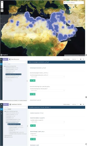
Originally devised to offer a paradigm for national heritage data management (Zerbini Citation2018), the EAMENA database has come to encompass a wide array of information including, at a basic level, the coordinates and extent of features or sites accompanied by a tentative interpretation, condition assessment, and exposure or vulnerability to future threats. EAMENA emphasizes documenting the data collection processes, including value classifications (e.g., certainty qualifiers) on the sources and observations used to produce archaeological interpretations (site location, periodization, disturbances, threats, etc.) (Fisher et al. Citation2021, 6) (). The formulation of terminology in EAMENA took into consideration a variety of geographical zones, chronological periods, and interdisciplinary approaches deriving from the project’s diverse research community (Zerbini Citation2018). The presence of expert-led identification combined with ground verification in the EAMENA database has led to its description as more “complete” and engaging (McCoy Citation2020, S23) but also more suitable for modelling future impacts.
Figure 2. Example of data entry in the EAMENA database. A) Distribution of archaeological sites documented by the EAMENA project. B) Excerpt from the database’s archaeological assessment form highlighting the use of certainty values. C) Excerpt from the database’s site condition assessment form (screenshots from database.eamena.org).
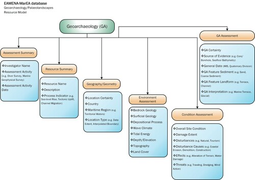
MarEA adopted the EAMENA database and, in the process, enhanced its existing terminology and documentation forms (referred to as heritage resource models) to include maritime-specific requirements. This included extending the thesauri to descriptions relevant to maritime environments and sites and incorporating new data documentation fields that contextualize maritime heritage and coastal change. One such development is the Geoarchaeological Resource Model (GRM), which enables the documentation of geological and geomorphological data (). This is intended to provide information on environmental and landscape change, which can aid in archaeological prospection, interpretation, and heritage management. This is a necessity for maritime archaeology, given changes in coastal configurations driven by Quaternary relative sea-level fluctuations, tectonics, and localized sedimentary processes, all of which operate to some extent across the MENA shoreline (Anzidei et al. Citation2011; Lambeck et al. Citation2011; Benjamin et al. Citation2017; Vacchi et al. Citation2018). The implications for the location and preservation of heritage sites are considerable. For instance, former terrestrial or coastal sites can be found submerged on the continental shelf, whilst former marine or coastal sites can be found buried under coastal sediments or uplifted above present sea-level (Flemming Citation1965; Besançon et al. Citation1994; Marriner and Morhange Citation2008; Galili et al. Citation2020). Finding and interpreting these sites within their appropriate paleolandscape context requires geological and geomorphological evidence of past environmental and landscape change (Flemming et al. Citation2017). Within MENA, this evidence is presently spread across the academic literature, with some elements contained within specialized databases (e.g., indicators of sea-level change: Pedoja et al. Citation2014; Vacchi et al. Citation2018), and not necessarily visualized geospatially without additional processing. The GRM provides easy access to the relevant data, as well as enabling a rapid overview of the geographic distribution and nature of the evidence and its relevance to archaeological research and management. This mirrors attempts elsewhere to integrate and record geological/geomorphological evidence for archaeological purposes (Flemming et al. Citation2017; EMODnet submerged landscapes database).
Figure 3. Ontological map of the Geoarchaeological Resource Model (produced on Microsoft Visio).
Data access
The EAMENA database is accessible through a registration process. Access permissions are provided at various levels from public access to researchers/users and data producers/editors. These levels of access guarantee the protection of sensitive data, if required, accounting for the requirements of national heritage partners and agencies, yet still encompassing the benefits of open data (transparency, accountability, and diversification of viewpoints) (Fisher et al. Citation2021, 6). MarEA regularly shares observations recorded in the database as blog posts on our official website (marea.soton.ac.uk) and in social media, making them available for feedback from specialists and interested parties.
The classification of data in the Arches database reflects the aim of the EAMENA and MarEA projects to readily enable retrieval of trans-regional and diachronic combinations of information. For instance, if a local stakeholder or a researcher is interested in the impact of coastal erosion on cultural heritage, they can search for “Erosion/Retreat” and “Inundation.” The search can be narrowed geographically or even expanded thematically, for instance to explore the correlation of erosion with other impacts such as “Building/Development” or “Seismic Activity.” Resources are often linked to bibliographic references, as well as values that classify the degree of certainty of threat (“Definite,” “High,” “Medium,” “Low,” or “Negligible”). This offers the user a prompt and informed selection of data that would be the most suitable for a particular question.
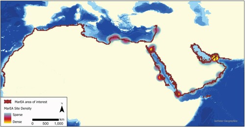
To date, the EAMENA database contains 331,894 individual records, 8398 of which have been documented by MarEA. This includes 167,335 Heritage Place records, of which 8329 have been produced by MarEA (). Heritage place records include sites, features, and archaeological landscapes, with associated information on nearby building and road infrastructure development, port development, offshore development, flooding, and erosion.
Figure 4. Map of MarEA site density in the EAMENA database (produced on ArcGIS Pro).
Local Collaborations
Engagement and close collaboration with local partners and stakeholders reinforce heritage networks with the MENA region, create opportunities for capacity building, and enable quality control on remotely-sensed data. MarEA aims to showcase the importance of remote sensing in heritage management and collect data via mutually beneficial approaches to MCH. Local collaborators are archaeologists identified via existing networks with governmental heritage agencies and universities and via their research output. As such, they represent a wide array of interests and capacities.
Training workshops
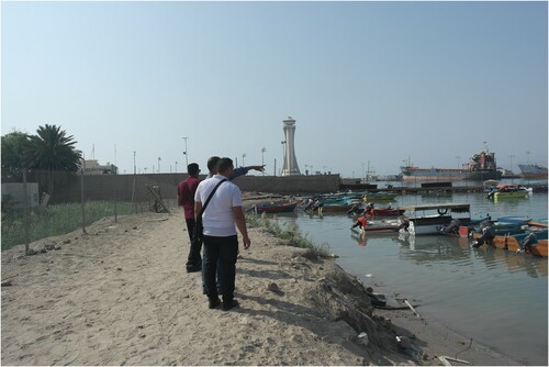
MarEA was included in EAMENA’s Cultural Protection Fund-supported training sessions and to date has offered MCH-specific training to archaeologists from Lebanon, Jordan, and Palestine. Participants developed maritime archaeological skillsets, used the EAMENA database, and engaged in discussion surrounding the ontological dimensions of the used terminology. These workshops encouraged the incorporation of specific local concerns, such as the potential of satellite-derived data to assess the maritime archaeology of Gaza. They also offered key information regarding how this data would be beneficial to non-academic local communities. One workshop included practical training in Aqaba, Jordan, where local partners ground verified remotely-sensed information but also tested site documentation and assessment forms that MarEA produced to collect information relevant to coastal vulnerability ().
Figure 5. Coastal vulnerability assessment in Aqaba, Jordan (photo by William Deadman, November 2019).
Co-production of data
Local archaeologists actively contribute to MarEA with their regional, chronological, and material expertise. They also enhance the database through the co-production of information that considers local perceptions and engagements with heritage. One such example is our collaborative data amalgamation with specialists on the MCH of Morocco and local archaeologists (Trakadas and Karra Citation2020). Data relevant to the MCH of Morocco are inventoried using the EAMENA database’s terminology, alongside in situ assessments of any damage and the vulnerability of those sites.
Fieldwork
In Libya, maritime archaeology is a young but growing discipline. Recent training initiatives (Hobson Citation2019; Leone et al. Citation2020; Nikolaus, Sherdrick, and Rayne Citation2020) focused on increasing terrestrial survey skills, as well as GIS and database knowledge. However, maritime-related recording techniques, data collection, and analysis have received little attention.
Since the Arab Spring (in 2011) and the ongoing political unrest in Libya, unregulated agricultural development and building activities have increased dramatically. Archaeological investigations along the northern and western stretch of Cyrenaica’s coastline have been limited to date, but previous surveys detailed a variety of sites, including Classical period harbors and settlements, production and industrial sites, fortified farms, military features, and burial features (Jones and Little Citation1971; Hesein Citation2014; Emrage Citation2015; Buzaian Citation2019; Tusa and Buccellato Citation2019). While threats and damage to sites (particularly erosion) are mentioned sporadically in previous studies (Flemming Citation1965; Bennett et al. Citation2004; Bennett Citation2018), a systematic and comprehensive condition assessment of MCH sites along the Cyrenaica coastline was lacking.
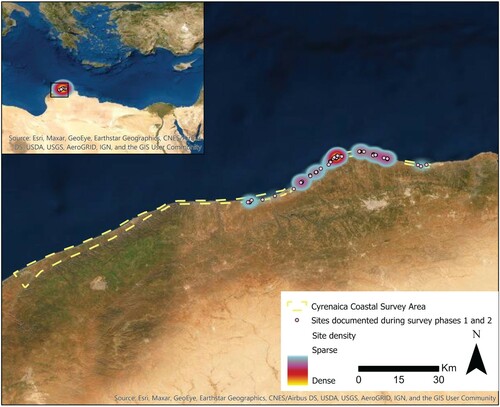
In 2020, MarEA established a collaborative pilot survey with the Department of Antiquities in Cyrenaica, Libya (DoA), to record threats and damage to archaeological sites along the coast of Cyrenaica between Apollonia (Susah) and Teucheira (Tocra) and to create a comprehensive condition assessment of coastal and submerged archaeological sites. The outcome of this survey will form the basis for the joint development of comprehensive protection and mitigation strategies for particularly vulnerable sites ().
Figure 6. Map showing sites documented during the first two phases of the Cyrenaica Coastal Survey (produced on ArcGIS).
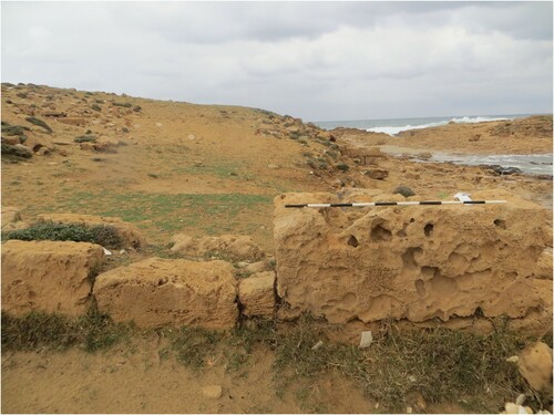
During this collaboration, MarEA conducted a desk-based assessment using open-access satellite imagery and published literature to identify and map potential sites in advance of field survey. The desk-based results were shared and discussed with the Libyan partners, and a joint decision was made on the final selection of target sites and suitable terminology for this survey. The ground verification and survey of these sites (coastal and underwater) was then carried out by members of the DoA using dedicated MarEA survey forms in Arabic that were tailored for threat and damage assessments (, ).
Figure 7. Rock-cut tombs at Phycus, many of which are used as storage facilities and domestic animal shelters (photo by the Cyrenaica Coastal Survey, CCS team, March 2021).
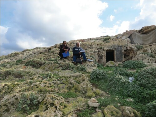
Figure 8. Remains of structures on the coast of Phycus (photo by the CCS team, March 2021).
This expert-led evaluation by the local survey team has provided accurate information about the validity of sites identified from satellite imagery. Preliminary results show that most sites recorded during the desk-based assessment were indeed pre-modern. However, a small number were, instead, natural rock formations or more recent constructions. Data quality was further improved by the identification of small features that are not identifiable on satellite imagery, such as small industrial installations and underwater features. The data collection and identification of threats facilitated through this collaboration allowed for enhanced data quality control and targeted, more contextualized management strategies. It also contributed to the research capacity and preparedness of partner organizations to implement local/regional responses to threat. Research capacity and intellectual reciprocity were accompanied by the creation of a five-part MCH training program in Arabic that covered subjects including underwater recording techniques and survey, GIS applications, drone surveys, and photogrammetry.
Example of Applications: Rapid Assessment of the Impact of Cyclone Shaheen in Oman
A big database that summarizes cultural heritage locales and their vulnerability can be instrumental in the impact assessment of unpredictable or inevitable catastrophic events, such as tropical cyclones that often strike the southern Arabian Peninsula. Oman is widely identified as exceptionally vulnerable to tropical cyclones, often affecting areas with a high density of maritime archaeological sites, such as the Muscat and the Dhofar Governorates (). Despite substantial research on impact assessment (Al Ruheili and Radke Citation2020), modelling (Hereher et al. Citation2020), and mitigation strategies (Mansour et al. Citation2021), cultural heritage is not yet incorporated in national policies for the protection of the environment and infrastructure.
Figure 9. Map of maritime archaeological sites in Oman documented in the EAMENA database in conjunction with major cyclonic tracks over the past 130 years (National Oceanic and Atmospheric Administration).
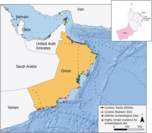
To demonstrate the potential of MarEA’s dataset, we use as a case study Cyclone Shaheen—a category-1 storm which made landfall in Oman on 3 October 2021. During the weeks following Cyclone Shaheen, we amalgamated all available archaeological information pertaining to the coastline between Muscat and Sohar, which experienced the worst consequences of this cyclone (see ). This included 184 sites, of which 41 had definite and 38 had high archaeological certainty. Documented features include the remains of coastal and near-coastal Islamic forts, traditional boats, historic buildings, and cities mentioned in historical archives and charts.
We subsequently assessed the broader impact of the cyclone through a rapid inspection of open-source Sentinel-2 (S2) satellite images covering the coastal strip. This helped us identify the area around the lower reaches of the Wadi al Hawasinah as suffering particularly severe impacts (). This was evidenced on the shoreline by breaches in previously-closed wadi mouths and inland by newly-cut or expanded networks of channels.
Figure 10. Satellite image showing the impact of Cyclone Shaheen at Wadi al Hawasinah. Documented forts are shown as yellow dots. A) Sentinel-2 pre-cyclone, true color image (dashed box indicates location of detailed view using Planetscope imagery). B) Sentinel-2 post-cyclone, true color image. C) Pre- vs. post-cyclone difference map of extracted water from Sentinel-2 images. D) Planetscope pre-cyclone, false color infra-red image (vegetation = red). E) Planetscope post-cyclone, false color infra-red image. F) Pre- vs. post-cyclone difference map of extracted water from Planetscope images.
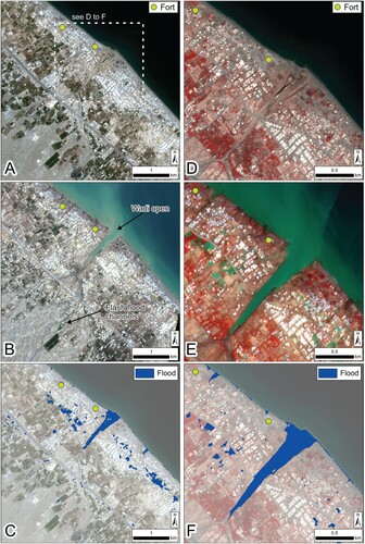
We then assessed the extent of potential impact in terms of flooding and shoreline change in the vicinity of these archaeological sites through a more detailed analysis. This comprised extraction of surface water from pre- and post-cyclone S2 images () using the Sentinel Water Index (SWI) and automated (Otsu) thresholding (Jiang et al. Citation2021), followed by differencing of the extracted pre- and post-event water layers (see also Tapete and Cigna Citation2020 for similar approaches applied to archaeological sites). These analyses indicated breach and flooding of the previously-closed wadi mouth and hinted at intermittent shoreline retreat (A–C). That this is not the result of higher tide is supported by modelled tides from the FES2014 global ocean tide atlas (Lyard et al. Citation2021; measured values from the Muscat tide gauge were not available at time of writing), which show that both pre- and post-event images were acquired at high water. Onshore, areas of standing water can be identified, with a particularly extensive zone located 0.4–1.6 km northwest of the wadi. This was also verified using similar techniques applied to higher resolution Planetscope images (see ), with the key differences identified with the use of McFeeters’ (Citation1996) Normalized Difference Water Index (NDWI) and manual thresholding. These show broadly similar patterns, albeit with slightly reduced surface water, but stronger evidence of shoreline recession and inland penetration along newly-flooded inlets (D–F). The severity of this impact is further illustrated by previous studies which show that the wadi mouth has usually been blocked since construction of a dam in 1995, and the coastline to its northwest is generally regarded as stable (Al-Hatrushi Citation2013).
Table 1. Summary metadata for satellite imagery used in the Cyclone Shaheen Assessment.
These images are of insufficient resolution to conclusively determine impacts on the specific documented sites, and the 2-day delay for the post-cyclone images also means that the immediate impact of flash flooding cannot be detected. Nevertheless, the results highlight that this area is vulnerable to cyclone-driven flash flooding, and the overall extent of remaining standing water suggests that flood waters could have reached the sites but had drained away by the time of image acquisition. Shoreline retreat does not seem to have reached the sites in this instance, but rapid localized retreat of up to several meters is suggested by the analysis. This, too, highlights the continued vulnerability of the area in light of the rising 21st century sea-level, intensified cyclone patterns, and possible accelerated coastal retreat (Vousdoukas et al. Citation2018, Citation2020; Hereher et al. Citation2020). As such, this case study demonstrates how the MarEA database in conjunction with other “Big Data” (in this case, the ever-expanding archive of open-source satellite imagery) enables rapid assessment and can be used to identify sites which require more frequent monitoring. In this case, site inspections are suggested to assess flash flood impacts, coupled with baseline survey against which future coastal changes can be monitored.
Conclusions
MCH constitutes some of the most significant datasets incorporated in narratives of human mobility and interregional interaction but also contains the most vulnerable assemblages in terms of preservation. The MCH of the MENA region, which is relatively marginalized in cultural heritage policies, is challenging to monitor at large scales and generally possesses a peripheral role in existing conversations on endangered archaeology. There is a critical need for rapid and cost-effective documentation of sites and associated threats in vulnerable, dynamic, and rapidly changing maritime landscapes. Although small-scale research was able to highlight the detrimental impact of natural and anthropogenic processes on specific maritime archaeological sites, the broader geographical impact of those processes remains unclear.
Extensive historical and archaeological research on the MCH of the MENA region has produced large quantities of information on past human activities, diachronic land use, and landscape alterations, which are disseminated in different formats, some more accessible than others. Moreover, the associated data have not been integrated. The aggregation of such vast datasets requires a systematic classification system that will reflect the historical and geographical particularities of the archaeologies of the MENA region via extensive consultation with a diverse array of experts. Though the primary purpose of the MarEA dataset is to facilitate the identification of vulnerable sites and mobilize monitoring and the development of mitigation strategies, the dataset also offers a unique opportunity to scholars to develop new research syntheses and directions.
In view of the lack of detailed and consistent documentation of MCH in the MENA region, a region central in global historical discourses, in this paper, we aimed to demonstrate the importance of big data in the context of endangered MCH. Rather than viewing a big dataset as a means of producing answers to longstanding questions about pre-modern human societies, we instead engage with it as a tool for enabling new avenues for investigation. While emphasizing the benefits of big data approaches to document endangered MCH, we are also keenly aware of the associated epistemological, ethical, and analytical challenges. Similarly, we share concerns about discourses focusing on the speed of data acquisition and processing (Caraher Citation2016, Citation2019) and invest in quality control through interdisciplinary research, site visits when possible, and local partnerships.
With a critical gaze on data collection, management, and dissemination processes and close engagement with quality control and local communities, big data approaches to MCH offer significant new data to archaeological research. Such approaches can open regional interpretations that are more empirical, relying on a wider variety of archaeological features and drawing on numerous archaeological assemblages through the combination of diverse datasets. At a local level, a large dataset would highlight broader patterns affecting MCH and mobilize action often impeded by the lack of accessible baseline data. With expert-led, locally informed, and regularly ground-verified data, we consider that MCH, people in charge of its stewardship, and local communities that have developed affective ties with it, would benefit immensely from big data approaches.
Additional information
Notes on contributors
Georgia M. Andreou
Georgia Andreou (Ph.D. 2015, University of Edinburgh) is a researcher at the University of Southampton and an associate lecturer at the Institute of Archaeology at UCL. Her interests include the prehistory of the Mediterranean and the Near East.
Julia Nikolaus
Julia Nikolaus (Ph.D. 2017, University of Leicester) is a researcher at Ulster University with a focus on North African archaeology and heritage protection.
Kieran Westley
Kieran Westley (Ph.D. 2007, University of Southampton) is a researcher at Ulster University. His interests include climate change, remote sensing, and submerged prehistory.
Crystal el Safadi
Crystal el Safadi (Ph.D. 2018, University of Southampton) is a researcher at the University of Southampton with expertise in maritime archaeology and archaeological computing. Her main interests are in digital approaches to the human past, prehistoric maritime mobility, and mapping technologies.
Lucy Blue
Ash Smith (Ph.D. 2008, University of Southampton) is a database engineer working at the University of Southampton.
Lucy Blue (D.Phil. 1996, University of Oxford) is a senior lecturer at the University of Southampton and co-director of the MarEA project. She is also the part-time maritime archaeological director of the Honor Frost Foundation.
Colin Breen
Colin Breen (Ph.D. 2003, National University of Ireland, Galway) is a Reader in the School of Geography and Environmental Sciences, Ulster University, and co-director of the MarEA project. He has research interests in maritime societies, environmental change, and conflict.
References
- Abu-Khafajah, S., and R. Miqdadi. 2019. “Prejudice, Military Intelligence, and Neoliberalism: Examining the Local Within Archaeology and Heritage Practices in Jordan.” Contemporary Levant 4 (2): 92–106.
- Al Ruheili, A., and J. Radke. 2020. ““Visualization of 2002 Storm Surge Along the Coast of Dhofar, Case Study of Oman.”.” Environment, Development and Sustainability 22: 501–517. https://doi.org/https://doi.org/10.1007/s10668-018-0186-z.
- Al-Hatrushi, S. 2013. “Monitoring of the Shoreline Change Using Remote Sensing and GIS: A Case Study of Al-Hawasnah Tidal Inlet, Al Batinah Coast, Sultanate of Oman.” Arabian Journal of Geosciences 6: 1479–1484. https://doi.org/https://doi.org/10.1007/s12517-011-0424-2.
- Andreou, G. M. 2018. “Monitoring the Impact of Coastal Erosion on Archaeological Sites: The Cyprus Ancient Shoreline Project.” Antiquity 92 (361): E4. doi:https://doi.org/10.15184/aqy.2018.1.
- Andreou, G., L. Blue, C. Breen, C. El Safadi, H. Huigens, J. Nikolaus, R. Ortiz-Vazquez, and K. Westley. 2020. “Maritime Endangered Archaeology of the Middle East and North Africa: The MarEA Project.” Antiquity 94 (378): E36. doi:https://doi.org/10.15184/aqy.2020.196.
- Andreou, G. M., A. Georgiou, T. M. Urban, K. D. Fisher, S. W. Manning, and D. A. Sewell. 2019. “Reconsidering Coastal Archaeological Sites in Late Bronze Age Cyprus: Tochni-Lakkia and the South-Central Coastscape.” Bulletin of the American Schools of Oriental Research 382: 33–69.
- Andreou, G. M., R. Opitz, S. W. Manning, K. D. Fisher, D. A. Sewell, A. Georgiou, and T. Urban. 2017. “Integrated Methods for Understanding and Monitoring the Loss of Coastal Archaeological Sites: The Case of Tochni-Lakkia, South-Central Cyprus.” Journal of Archaeological Science: Reports 12: 197–208.
- Anzidei, M., F. Antonioli, K. Lambeck, A. Benini, M. Soussi, and R. Lakhdar. 2011. “New Insights on the Relative Sea Level Change During Holocene Along the Coasts of Tunisia and Western Libya from Archaeological and Geomorphological Markers.” Quaternary International 232 (1-2): 5–12.
- Atkinson, D., and A. Hale2012. A Marine and Maritime Scottish Archaeological Research Framework. Edinburgh: Society of Antiquaries of Scotland.
- Azoulay, A. 2019. Potential History: Unlearning Imperialism. London: Verso.
- Benjamin, J., A. Rovere, A. Fontana, S. Furlani, M. Vacchi, R. H. Inglis, E. Galili, F. Antonioli, D. Sivan, S. Miko, N. Mourtzas, I. Felja, M. Meredith-Williams, B. Goodman-Tchernov, E. Kolaiti, M. Anzidei, and R. Gehrels. 2017. “Late Quaternary Sea-Level Changes and Early Human Societies in the Central and Eastern Mediterranean Basin: An Interdisciplinary Review.” Quaternary International 449: 29–57.
- Bennett, P. 2018. “Notes from Libya.” Libyan Studies 49: 211–222.
- Bennett, P., A. Wilson, A. Buzaian, and A. Kattenberg. 2004. “The Effects of Recent Storms on the Exposed Coastline of Tocra.” Libyan Studies 35: 113–122.
- Besançon, J., L. Copeland, S. Muhesen, and P. Sanlaville. 1994. “Prospection Géomorphologique et Préhistorique Dans la Région de Tartous (Syrie).” Paléorient 20: 5–19.
- Bewley, B., D. Kennedy, F. Radcliffe, K. Henderson, and S. Smith. 2010. “Aerial Archaeology in Jordan 2010: A Brief Up-Date.” The Newsletter of the Aerial Archaeology Research Group 41: 13–24.
- Bewley, R., A. I. Wilson, D. Kennedy, D. Mattingly, R. Banks, M. Bishop, J. Bradburry, E. Cunliffe, M. Fradley, R. Jennings, R. Mason, L. Rayne, M. Sterry, N. Sheldrick, and A. Zerbini. 2016. “Endangered Archaeology in the Middle East and North Africa: Introducing EAMENA Project.” In CAA 2015. Keep the Revolution Going: Proceedings of the 43rd Annual Conference on Computer Applications and Quantitative Methods in Archaeology, edited by S. Campana, R. Scopigno, G. Carpentiero, and M. Cirillo, 919–932. Oxford: Archaeopress Archaeology.
- Binding, C., and D. Tudhope. 2016. “Improving Interoperability Using Vocabulary Linked Data.” International Journal on Digital Libraries 17: 5–21.
- Bitan, M., E. Galili, E. Spanier, and D. Zviely. 2020. “Beach Nourishment Alternatives for Mitigating Erosion of Ancient Coastal Sites on the Mediterranean Coast of Israel.” Journal of Marine Science and Engineering 8 (7): 509. https://doi.org/https://doi.org/10.3390/jmse8070509.
- Blue, L., and C. Breen. 2019. “Maritime Archaeology and Capacity Development in the Global South.” Journal of Maritime Archaeology 14: 321–332. https://doi.org/https://doi.org/10.1007/s11457-019-09244-x.
- Brady, L., M. D. Howland, and T. E. Levy. 2017. “Testing Google Earth Engine for the Automatic Identification and Vectorization of Archaeological Features: A Case Study from Faynan, Jordan.” Journal of Archaeological Science: Reports 15: 299–304.
- Breen, C., C. El Safadi, H. Huigens, S. Tews, K. Westley, G. Andreou, R. Ortiz-Vazquez, J. Nikolaus, and L. Blue. 2021. “Integrating Cultural and Natural Heritage Approaches to Marine Protected Areas in the MENA Region.” Marine Policy 132: 104676.
- Brooks, N., J. Clarke, G. Wambui Ngaruiya, and E. E. Wangui. 2020. “African Heritage in a Changing Climate.” Azania: Archaeological Research in Africa 55 (3): 297–328.
- Buzaian, A. M. 2019. “Ancient Olive Presses and Oil Production in Cyrenaica (North-East Libya).” PhD. diss., University of Leicester, Leicester.
- Candela, G., P. Escobar, R. C. Carrasco, and M. Marco-Such. 2018. “A Linked Open Data Framework to Enhance the Discoverability and Impact of Cultural Heritage.” Journal of Information Science 45 (6): 756–766.
- Caraher, W. R. 2016. “Slow Archaeology: Technology, Efficiency, and Archaeological Work.” In Mobilizing the Past for a Digital Future: The Potential of Digital Archaeology, edited by W. W. Averett, J. M. Gordon, and D. B. Counts, 421–441. Grand Forks, ND: The Digital Press.
- Caraher, W. R. 2019. “Slow Archaeology, Punk Archaeology, and the ‘Archaeology of Care’.” European Journal of Archaeology 22 (3): 372–385.
- Casana, J. 2014. “Regional-Scale Archaeological Remote Sensing in the Age of Big Data: Automated Site Discovery vs. Brute Force Methods.” Advances in Archaeological Practice 2 (3): 222–233.
- Casana, J. 2020. “Global-Scale Archaeological Prospection Using CORONA Satellite Imagery: Automated, Crowd-Sourced, and Expert-Led Approaches.”.” Journal of Field Archaeology 45 (S1): S89–S100.
- Casana, J., and J. Cothren. 2013. “The CORONA Atlas Project: Orthorectification of CORONA Satellite Imagery and Regional-Scale Archaeological Exploration in the Near East.” In Mapping Archaeological Landscapes from Space, edited by D. Comer, and M. J. Harrower, 33–43. London: Springer.
- Casana, J., and E. J. Laugier. 2017. “Satellite Imagery-Based Monitoring of Archaeological Site Damage in the Syrian Civil War.” PLOS ONE 12 (11): e0188589.
- Casana, J., and M. Panahipour. 2014. “Notes on a Disappearing Past: Satellite-Based Monitoring of Looting and Damage to Archaeological Sites in Syria.” Journal of Eastern Mediterranean Archaeology and Heritage Sites 2 (2): 128–151.
- Contreras, D., and N. J. Brodie. 2010. “The Utility of Publicly Available Satellite Imagery for Investigating Looting of Archaeological Sites in Jordan.” Journal of Field Archaeology 35 (1): 101–114.
- Crofts, N., M. Doerr, T. Gill, S. Stead, and M. Stiff2008. “Definition of the CIDOC Conceptual Reference Model.” Accessed April 2021. http://cidoc.ics.forth.gr/index.html.
- Cunliffe, E. 2014. “Archaeological Site Damage in the Cycle of War and Peace: A Syrian Case Study.” Journal of Eastern Mediterranean Archaeology and Heritage Studies 2 (2): 229–247.
- Cunliffe, E., and L. Curini. 2018. “ISIS and Heritage Destruction: A Sentiment Analysis.” Antiquity 92 (364): 1094–1111.
- Dallas, C. 2015. “Curating Archaeological Knowledge in the Digital Continuum. from Practice to Infrastructure.” Open Archaeology 1: 176–207.
- Demesthicha, S., L. Semaan, and Z. Morsy. 2019. “Capacity Building in Maritime Archaeology: The Case of the Eastern Mediterranean (Cyprus, Lebanon and Egypt).” Journal of Maritime Archaeology 14 (3): 369–389.
- Dennis, L. M. 2020. “Digital Archaeological Ethics: Successes and Failures in Disciplinary Attention.” Journal of Computer Applications in Archaeology 3 (1): 210–218.
- Drzewiecki, M., and M. Arinat. 2017. “The Impact of Online Archaeological Databases on Research and Heritage Protection in Jordan.” Levant 49 (1): 64–77.
- El-Asmar, H. M., M. H. Ahmed, M. M. N. Taha, and E. M. Assal. 2012. “Human Impacts on Geological and Cultural Heritage in the Coastal Zone West of Alexandria to Al-Alamein, Egypt.” Geoheritage 7: 263–274.
- El-Magd, A., M. Z. Islam, A. M. Abdulaziz, and E. M. Ali. 2020. “The Potentiality of Operational Mapping of Oil Pollution in the Mediterranean Sea Near the Entrance of the Suez Canal Using Sentinel-1 SAR Data.” Remote Sensing 12 (8): 1352.
- EMODnet Submerged Landscapes. Accessed April. 2021. https://www.emodnet-geology.eu/data-products/submerged-landscapes/.
- Emrage, A. S. 2015. “Roman Fortified Farms (Qsur) and Military Sites in the Region of the Wadi Al-Kuf, Cyrenaica (Eastern Libya)”. Ph.D. diss., University of Leicester, Leicester.
- Erlandson, J. J. 2012. “As the World Warms: Rising Seas, Coastal Archaeology, and the Erosion of Maritime History.” Journal of Coastal Conservation 16 (2): 137–142.
- Fernandez-Diaz, J. C., A. S. Cohen, A. M. González, and C. T. Fisher. 2018. “Shifting Perspectives and Ethical Concerns in the Era of Remote Sensing Technologies.” The SAA Archaeological Record 18 (2): 8–15.
- Fisher, M., M. Fradley, P. Flohr, B. Rouhani, and F. Simi. 2021. “Ethical Considerations of Remote Sensing and Open Data in Relation to the Endangered Archaeology in the Middle East and North Africa Project.” Archaeological Prospection 2021: 1–14.
- Flatman, J. 2009. “Conserving Marine Cultural Heritage: Threats, Risks and Future Priorities.” Conservation and Management of Archaeological Sites 11: 5–8.
- Flemming, N. C. 1965. “Underwater Survey of Apollonia.” In Marine Archaeology. Developments During Sixty Years in the Mediterranean, edited by J. Du Plat Taylor, 168–78. London: Hutchinson & Co.
- Flemming, N. C., J. Harff, D. Moura, A. Burgess, and G. N. Bailey2017. Submerged Landscapes of the European Continental Shelf: Quaternary Palaeoenvironments. Hoboken: Wiley-Blackwell.
- Fradley, M., and N. Sheldrick. 2017. “Satellite Imagery and Heritage Damage in Egypt: A Response to Parcak et al. (2016).” Antiquity 91 (357): 784–792.
- Franklin, K., and E. Hammer. 2018. “Untangling Palimpsest Landscapes in Conflict Zones: A “Remote Survey” in Spin Boldak, Southeast Afghanistan.” Journal of Field Archaeology 43 (1): 58–73.
- Galili, E., A. Oron, and D. Cvikel. 2018. “Five Decades of Marine Archaeology in Israel.” Journal of Eastern Mediterranean Archaeology and Heritage Studies 6 (1-2): 99–141.
- Galili, E., and B. Rosen. 2010. “Preserving the Maritime Cultural Heritage of the Mediterranean.” Journal of Coastal Conservation 14: 305–315.
- Galili, E., B. Rosen, M. Weinstein Evron, I. Hershkovitz, V. Eshed, and L. Kolska Horwitz. 2020. “Israel: Submerged Prehistoric Sites and Settlements on the Mediterranean Coastline—the Current State of the Art.” In The Archaeology of Europe’s Drowned Landscapes, edited by G. Bailey, N. Galanidou, H. Peeters, H. Jöns, and M. Mennenga, 443–481. Cham: Springer.
- Gattiglia, G. 2015. “Thinking Big About Data: Archaeology and the Big Data Challenge.” Archäologische Informationen 38 (1): 113–124.
- Goode, J. F. 2007. Negotiating for the Past: Archaeology, Nationalism, and Diplomacy in the Middle East, 1919–1941. Austin: University of Texas Press.
- Gorelick, N., M. Hancher, M. Dixon, S. Ilyushchenko, D. Thau, and R. Moore. 2017. “Google Earth Engine: Planetary-Scale Geospatial Analysis for Everyone.” Remote Sensing of Environment 202: 18–27.
- Green, C. 2020. “Challenges in the Analysis of Geospatial ‘Big Data’.” In Archaeological Spatial Analysis. A Methodological Guide, edited by M. Gillings, P. Hacigüzeller, and G. Lock, 430–433. London: Routledge.
- Gupta, N., S. Blair, and R. Nicholas. 2020. “What We See, What We Don’t See: Data Governance, Archaeological Spatial Databases and the Rights of Indigenous Peoples in an Age of Big Data.” Journal of Field Archaeology 45 (S1): S39–S50.
- Hamilakis, Y. 2007. “From Ethics to Politics.” In Archaeology and Capitalism: From Ethics to Politics, edited by Y. Hamilakis, and P. Duke, 15–40. Walnut Creek: Left Coast Press.
- Hamilakis, Y. 2009. “The “War on Terror” and the Military Archaeology Complex: Iraq, Ethics, and Neo-Colonialism.” Archaeologies 5 (1): 39–65.
- Hamilakis, Y. 2012. ““ … Not Being at Home is One’s Home”: Ontology, Temporality, Critique.” Forum Kritische Archäologie 1: 12–23.
- Hamilakis, Y. 2014. Archaeology and the Senses: Human Experience, Memory and Affect. Cambridge: Cambridge University Press.
- Hammer, E. 2019. “The City and Landscape of Ur: An Aerial, Satellite and Ground Reassessment.” Iraq 81: 173–206.
- Hammer, E., and J. Ur. 2019. “Near Eastern Landscapes and Declassified U2 Aerial Imagery.” Advances in Archaeological Practice 7 (2): 107–126.
- Hanson, K. 2012. “Considerations of Cultural Heritage: Threats to Mesopotamian Archaeological Sites.” Ph.D. diss., University of Chicago, Chicago.
- Harrison, R. 2012. Heritage. Critical Approaches. London: Routledge.
- Henderson, J., C. Breen, L. Esteves, A. La Chimia, P. Lane, S. Macamo, G. Marvin, and S. Wynne-Jones. 2021. “Rising from the Depths Network: A Challenge-Led Research Agenda for Marine Heritage and Sustainable Development in Eastern Africa.” Heritage 4: 1026–1048. https://doi.org/https://doi.org/10.3390/heritage4030057.
- Henninger, M. 2017. “From Mud to the Museum: Metadata Challenges in Archaeology.” Journal of Information Science 44 (5): 658–670.
- Hereher, M., T. Al-Awadhi, S. Al-Hatrushi, Y. Charabi, S. Mansour, N. Al-Nasiri, Y. Sherief, and A. El-Kenawy. 2020. “Assessment of Coastal Vulnerability to Sea Level Rise: Sultanate of Oman.” Environmental Earth Sciences 79: 369. https://doi.org/https://doi.org/10.1007/s12665-020-09113-0.
- Hesein, M. A. 2014. “Bridging the Eastern and Western Mediterranean: The Roman Harbour Sites on the Coast of Cyrenaica, North-Eastern Libya.” Ph.D. diss., University of Leicester, Leicester.
- Hicks, D. 2020. The Brutish Museums. The Benin Bronzes, Colonial Violence and Cultural Restitution. London: Pluto Press.
- Hobson, M. S. 2019. “EAMENA Training in the Use of Satellite Remote Sensing and Digital Technologies in Heritage Management: Libya and Tunisia Workshops 2017–2019.” Libyan Studies 50: 63–71.
- Hoffman, R. R. 2018. “Cognitive and Perceptual Processes in Remote Sensing Image Interpretation.” In Remote Sensing and Cognition: Human Factors in Image Interpretation, edited by R. A. White, C. Arzu, and R. R. Hoffman, 1–18. Boca Raton: CRC Press.
- Holtorf, C., and T. M. Kristensen. 2015. “Heritage Erasure: Rethinking ‘Protection’ and ‘Preservation’.” International Journal of Heritage Studies 21 (4): 313–317.
- Hritz, C. 2008. “Remote Sensing of Cultural Heritage in Iraq: A Case Study of Isin.” TAARII Newsletter 3: 1–8.
- Huggett, J. 2015. “A Manifesto for an Introspective Digital Archaeology.” Open Archaeology 1: 86–95.
- Huggett, J. 2020. “Is Big Data Different? Towards a New Archaeological Paradigm.” Journal of Field Archaeology 45 (1): S8–S17.
- Huvila, I., and J. Huggett. 2018. “Archaeological Practices, Knowledge Work and Digitalisation.” Journal of Computer Applications in Archaeology 1 (1): 88–100.
- Hzami, A., E. Heggy, O. Amrouni, G. Mahe, M. Manaan, and S. Abdeljaouad. 2021. “Alarming Coastal Vulnerability of the Deltaic and Sandy Beaches of North Africa.” Scientific Reports 11: 2320. https://doi.org/https://doi.org/10.1038/s41598-020-77926-x.
- Jiang, W., Y. Ni, Z. Pang, X. Li, H. Ju, G. He, J. Lv, K. Yang, J. Fu, and X. Qin. 2021. “An Effective Water Body Extraction Method with New Water Index for Sentinel-2 Imagery.” Water 13: 1647. https://doi.org/https://doi.org/10.3390/W13121647.
- Jones, G. D. B., and J. H. Little. 1971. “Coastal Settlement in Cyrenaica.” Journal of Roman Studies 61: 64–79.
- Kersel, M., and A. Hill. 2020. “Databases, Drones, Diggers, and Diplomacy: The Jordanian Request for a US Cultural Property Bilateral Agreement.” Journal of Field Archaeology 45 (S1): S101–S110.
- Khalil, E. 2008. “Education in Maritime Archaeology: The Egyptian Case Study.” Journal of Maritime Archaeology 3 (2): 85–91.
- Khatchadourian, L. 2020. “Education Beyond Preservation. An Archaeological Camp for Girls in Armenia.” Near Eastern Archaeology 83 (4): 248–255.
- Khatchadourian, L., I. Lindsay, and A. Smith. 2021. Caucasus Heritage Watch Report 1. Cornell Institute of Archaeology and Material Studies.
- Kitchin, R. 2014. “Big Data, New Epistemologies and Paradigm Shifts.” Big Data and Society 1 (1): 1–12.
- Kvamme, K. 2018. “Getting Around the Black Box: Teaching (Geophysical) Data Processing Through GIS.” Journal of Computer Applications in Archaeology 1 (1): 74–87.
- LaBianca, ØS, M. E. Ronza, and N. Haris. 2020. “Community Archaeology in the Islamic World.” In The Oxford Handbook of Islamic Archaeology, edited by B. J. Walker, T. Insoll, and C. Fenwick, 1–15. Oxford: Oxford University Press.
- Lambeck, K., A. Purcell, N. C. Flemming, C. Vita-Finzi, A. M. Alsharekh, and G. N. Bailey. 2011. “Sea Level and Shoreline Reconstructions for the Red Sea: Isostatic and Tectonic Considerations and Implications for Hominin Migration Out of Africa.” Quaternary Science Reviews 30: 3542–3574.
- Lawrence, D., M. Altaweel, and G. Philip, eds. 2020. New Agendas in Remote Sensing and Landscape Archaeology in the Near East. Studies in Honour of Tony J. Wilkinson. Oxford: Archaeopress.
- Lawrence, D., J. Bradbury, and R. Dunford. 2012. “Chronology, Uncertainty and GIS: A Methodology for Characterising and Understanding Landscapes of the Ancient Near East.” In Landscape Archaeology. Proceedings of the International Conference Held in Berlin, 6th-8th June 2012, Special Volume 3, edited by W. Bebermeier, R. Hebenstreit, E. Kaiser, and J. Krause, 353–359. Berlin: Excellence Cluster Topoi.
- Leone, A., W. Wootton, C. Fenwick, M. Nebbia, H. Alkhalaf, G. Jorayev, A. Othman, M. A. Alhddad, M. Belzic, A. Emrage, Z. Siala and, P. Voke. 2020. “An Integrated Methodology for the Documentation and Protection of Cultural Heritage in the MENA Region: A Case Study from Libya and Tunisia.” Libyan Studies 51: 141–168.
- Liss, B., M. D. Howland, and T. E. Levy. 2017. “Testing Google Earth Engine for the Automatic Identification and Vectorization of Archaeological Features: A Case Study from Faynan, Jordan.” Journal of Archaeological Science: Reports 15: 299–304.
- Lohr, S. 2015. Dataism: Inside the Big Data Revolution. London: Oneworld.
- Long, D. L. 2000. “Cultural Heritage Management in Post-Colonial Polities: Not the Heritage of the Other.” International Journal of Heritage Studies 6 (4): 317–322.
- Lyard, F., D. Allain, M. Cancet, M. L. Carrère, and N. Picot. 2021. “FES2014 Global Ocean Tide Atlas: Design and Performance”. Ocean Science 17: 615–649. https://doi.org/https://doi.org/10.5194/OS-17-615-2021.
- Mansour, S., S. Darby, J. Leyland, and P. M. Atkinson. 2021. “Geospatial Modelling of Tropical Cyclone Risk Along the Northeast Coast of Oman: Marine Hazard Mitigation and Management Policies.” Marine Policy 129: 104544. https://doi.org/https://doi.org/10.1016/j.marpol.2021.104544.
- Marriner, N., and C. Morhange. 2008. “Preserving Lebanon’s Coastal Archaeology: Beirut, Sidon and Tyre.” Ocean and Coastal Management 51: 430–41.
- Mattingly, D. J., V. Leitch, C. N. Duckworth, A. Cuenod, M. Sterry, and F. Cole. 2017. Trade in the Ancient Sahara and Beyond. Trans-Saharan Archaeology. Cambridge: Cambridge University Press.
- McAnany, P. A., and S. M. Rowe. 2015. “Re-Visiting the Field: Collaborative Archaeology as Paradigm Shift.” Journal of Field Archaeology 40 (5): 499–507.
- McCarthy, J. K., J. Benjamin, T. Winton, and W. van Duivenvoorde2019. 3D Recording and Interpretation for Maritime Archaeology. Cham: Springer.
- McCoy, M. D. 2017. “Geospatial Big Data in Archaeology: Prospects and Problems Too Great to Ignore.” Journal of Archaeological Science 84: 74–94.
- McCoy, M. D. 2020. “The Site Problem: A Critical Review of the Site Concept in Archaeology in the Digital Age.” Journal of Field Archaeology 45 (S1): S18–S26.
- McFeeters, S. K. 1996. “The Use of the Normalized Difference Water Index (NDWI) in the Delineation of Open Water Features.” International Journal of Remote Sensing 17: 1425–1432.
- Meghini, M., R. Scopigno, J. Richards, H. Wright, G. Geser, S. Cuy, J. Fihn, B. Fanini, H. Hollander, F. Niccolucci, A. Felicetti, P. Ronzino, F. Nurra, C. Papatheodorou, D. Gavrilis, M. Theodoridou, M. Doerr, D. Tudhope, C. Binding, and A. Vlachidis. 2017. “ARIADNE: A Research Infrastructure for Archaeology.” Journal on Computing and Cultural Heritage 10 (3), https://doi.org/https://doi.org/10.1145/3064527.
- Meskell, L. 2018. A Future in Ruins: UNESCO, World Heritage, and the Dream of Peace. New York: Oxford University Press.
- Meskell, L. 2020a. “Hijacking ISIS. Digital Imperialism and Salvage Politics.” Archaeological Dialogues 27 (2): 126–128.
- Meskell, L. 2020b. “Imperialism, Internationalism, and Archaeology in the Un/Making of the Middle East.” American Anthropologist 127 (3): 554–567.
- Mickel, A. 2020. “The Proximity of Communities to the Expanse of Big Data.” Journal of Field Archaeology 45 (s1): S51–S60.
- Muis, S., M. Verlaan, H. C. Winsemius, J. C. J. H. Aerts, and P. J. Ward. 2016. “A Global Reanalysis of Storm Surges and Extreme Sea Levels.” Nature Communications 7), https://doi.org/https://doi.org/10.1038/ncomms11969.
- Myers, A. 2010a. “Camp Delta, Google Earth and the Ethics of Remote Sensing in Archaeology.” World Archaeology 42 (3): 55–67.
- Myers, A. 2010b. “Fieldwork in the Age of Digital Reproduction: A Review of the Potentials and Limitations of Google Earth for Archaeologists.” SAA Archeological Record 10 (4): 7–11.
- Neumann, B., A. T. Vafeidis, J. Zimmermann, and R. J. Nicholls. 2015. “Future Coastal Population Growth and Explosure to Sea-Level Rise and Coastal Flooding - A Global Assessment.” PLOS ONE 10 (6): e0131375. https://doi.org/https://doi.org/10.1371/journal.pone.0131375.
- Nikolaus, J., N. Sherdrick, and L. Rayne. 2020. “The EAMENA and MarEA Projects: Notes on Current Training and Research in Libya.” Quaderni di Archeologia della Libya 22: 203–206.
- Opitz, R., and J. Herrmann. 2018. “Recent Trends and Long-Standing Problems in Archaeological Remote Sensing.” Journal of Computer Applications in Archaeology 1: 19–41.
- Orengo, H. A., F. C. Conesa, A. Garcia-Molsosa, A. Lobo, A. S. Green, M. Madella, and C. A. Petrie. 2020. “Automated Detection of Archaeological Mounds Using Machine-Learning Classification of Multisensor and Multitemporal Satellite Data.” PNAS 117 (31): 18240–8250.
- Orengo, H. A., and A. Garcia-Molsosa. 2019. “A Brave New World for Archaeological Survey: Automated Machine Learning-Based Potsherd Detection Using High-Resolution Drone Imagery.” Journal of Archaeological Science 112: 105013.
- The Oxford Roman Economy Project. Accessed April. 2021. http://oxrep.classics.ox.ac.uk/databases/shipwrecks_database/.
- Parcak, S. 2007. “Satellite Remote Sensing Methods for Monitoring Archaeological Tells in the Middle East.” Journal of Field Archaeology 32 (1): 65–81.
- Parcak, S. 2015. “Archaeological Looting in Egypt: A Geospatial View (Case Studies from Saqqara, Lisht, and el Hibeh).” Near Eastern Archaeology 78 (3): 196–203.
- Parcak, S. 2019. Archaeology from Space: How the Future Shapes Our Past. New York: Henry Holt and Company.
- Pedoja, K., L. Husson, M. E. Johnson, D. Melnick, C. Witt, S. Pochat, M. Nexer, B. Delcaillau, T. Pinegina, Y. Poprawski, C. Authemayou, M. Elliot, V. Regard, and F. Garestier. 2014. “Coastal Staircase Sequences Reflecting Sea-Level Oscillations and Tectonic Uplift During the Quaternary and Neogene.” Earth Science Reviews 132: 13–38.
- Pollock, S. 2016. “Archaeology and Contemporary Warfare.” Annual Review of Anthropology 45: 215–231.
- Pollock, S., and R. Bernbeck. 2018. “Reflections on Survey and Surveillance in the Archaeology of Western Asia.” Origini 42 (2): 93–108.
- Pourkerman, M., N. Marriner, C. Morhange, M. Djamali, S. Amjadi, H. Lahijani, A. Naderi Beni, M. Vacchi, H. Tofighian, and M. Shah-Hoesseini. 2018. “Tracking Shoreline Erosion of “At Risk” Coastal Archaeology: The Example of Ancient Siraf (Iran, Persian Gulf).” Applied Geography 101: 45–55.
- Rabbat, N. 2020. “Heritage in Context.” In The Oxford Handbook of Islamic Archaeology, edited by B. J. Walker, T. Insoll, and C. Fenwick, 1–20. Oxford: Oxford University Press.
- Ragin, R. M., and G. Riccò. 2019. “Contemporary Epistemologies of Militarization in the Global South: Palimpsests and Accumulative Processes in Lampedusa and Lebanon.” Cultural Dynamics 31 (4): 291–307.
- Ransley, J., F. Sturt, J. Dix, J. Adams, and L. K. Blue. 2013. People and the Sea: A Maritime Archaeological Research Agenda. York: Council for British Archaeology.
- Rayne, L., J. Bradbury, D. Mattingly, G. Philip, R. Bewley, and A. Wilson. 2017. “From Above and On the Ground: Geospatial Methods for Recording Endangered Archaeology in the Middle East and North Africa.” Geosciences 7 (4): 100.
- Rayne, L., M. C. Gatto, L. Abdulaati, M. Al-Haddad, M. Sterry, N. Sheldrick, and D. Mattingly. 2020. “Detecting Change at Archaeological Sites in North Africa Using Open-Source Satellite Imagery.” Remote Sensing 12 (22): 3694. https://doi.org/https://doi.org/10.3390/rs12223694.
- Recinos, K., and L. Blue. 2019. “Improving Capacity Development for Threatened Maritime and Marine Cultural Heritage Through the Evaluation of a Parameter Framework.” Journal of Maritime Archaeology 14: 409–427.
- Reimann, L., A. T. Vafeidis, S. Brown, J. Hinkel, and S. J. Tol. 2018. “Mediterranean UNESCO World Heritage at Risk from Coastal Flooding and Erosion Due to Sea-Level Rise.” Nature Communications 9: 4161. https://doi.org/https://doi.org/10.1038/s41467-018-06645-9.
- Rico, T. 2015. “Heritage at Risk. The Authority and Autonomy of a Dominant Preservation Framework.” In Heritage Keywords. Rhetoric and Redescription in Cultural Heritage, edited by K. Lafrenz-Samuels and T. Rico, 147–162. Boulder: University Press of Colorado.
- Rico, T. 2017a. “Technology, Technocracy, and the Promise of ‘Alternative’ Heritage Values.” In Heritage in Action: Making the Past in the Present, edited by H. Silverman, E. Waterton, and S. Watson, 217–230. New York: Springer.
- Rico, T. 2017b. “Expertise and Heritage Ethics in the Middle East.” International Journal of Middle Eastern Studies 49: 742–746.
- Rico, T. 2020. “Is There an “Islamic” Practice for the Preservation of Cultural Heritage?” In The Oxford Handbook of Islamic Archaeology, edited by B. J. Walker, T. Insoll, and C. Fenwick, 1–16. Oxford: Oxford University Press.
- Ringer, R. V., and L. C. Loschky. 2018. “Head in the Clouds, Feet on the Ground: Applying Our Terrestrial Minds to Satellite Perspectives.” In Remote Sensing and Cognition: Human Factors in Image Interpretation, edited by R. A. White, A. Coltekin, and R. R. Hoffman, 63–86. Boca Raton: CRC Press.
- Samargandi, N. 2021. “Oil Exploration, Biocapacity, and Ecological Footprint in Saudi Arabia.” Environmental Science and Pollution Research 28: 54621–54629.
- Samuels, K. L. 2009. “Trajectories of Development: International Heritage Management of Archaeology in the Middle East and North Africa.” Archaeologies 5 (1): 68–91.
- Savage, S. H., A. Johnson, and T. E. Levy. 2017. “TerraWatchers, Crowdsourcing, and At-Risk World Heritage in the Middle East.” In Heritage and Archaeology in the Digital Age, edited by M. L. Vincent, V. M. López-Menchero Bendicho, M. Ioannides, and T. E. Levy, 67–77. New York: Springer.
- Savage, S., and T. E. Levy. 2014. “DAAHL – The Digital Archaeological Atlas of the Holy Land: A Model for Mediterranean and World Archaeology.” Near Eastern Archaeology 73 (3): 243–247.
- Scassa, T. 2017. “Legal Rights and Spatial Media.” In Understanding Spatial Media, edited by R. Kitching, T. Lauriault, and M. Wilson, 150–160. London: SAGE.
- Semaan, L. 2018. “Maritime Archaeology in the Developing World. The Case of Lebanon.” Journal of Eastern Mediterranean Archaeology and Heritage Studies 6 (1-2): 79–98.
- Soroush, M., A. Mehrtash, E. Khazraee, and J. Ur. 2020. “Deep Learning in Archaeological Remote Sensing: Automated Qanat Detection in the Kurdistan Region of Iraq.” Remote Sensing 12 (3): 500. https://doi.org/https://doi.org/10.3390/rs12030500.
- Stahl, A. B. 2020. “Assembling “Effective Archaeologies” Toward Equitable Future.” American Anthropologist 122 (1): 37–50.
- Stobiecka, M. 2020. “Archaeological Heritage in the Age of Digital Colonialism.” Archaeological Dialogues 27: 113–125.
- Stocker, J. 2012. “No EEZ Solution: The Politics of Oil and Gas in the Eastern Mediterranean.” The Middle East Journal 66 (4): 579–597.
- Tang, C. 2016. The Data Industry: The Business and Economics of Information and Big Data. New York: Wiley and Sons.
- Tapete, D., and F. Cigna. 2020. “Poorly Known 2018 Floods in Bosra UNESCO Site and Sergiopolis in Syria Unveiled from Space Using Sentinel-1/2 and COSMO-SkyMed.” Scientific Reports 10: 12307. https://doi.org/https://doi.org/10.1038/s41598-020-69181-x.
- Tapete, D., F. Cigna, and D. N. Donoghue. 2016. “Looting Marks in Space-Borne SAR Imagery: Measuring Rates of Archaeological Looting in Apamea (Syria) with TerraSAR-X Staring Spotlight.” Remote Sensing of Environment 178 (1): 42–58.
- Trakadas, A. 2020. “Natural and Anthropogenic Factors Influencing Northern Morocco’s Coastal Archaeological Heritage: A Preliminary Assessment.” The Journal of Island and Coastal Archaeology, DOI: https://doi.org/10.1080/15564894.2020.1837304.
- Trakadas, A., and A. Karra. 2020. “Essaouira’s Coastal Heritage, Morocco”. Accessed May 2021. marea.soton.ac.uk/2020/09/01/essaouiras-maritime-cultural-heritage-morocco/.
- Tusa, S., and C. A. Buccellato. 2019. “Coastal Archaeology of East Cyrenaica Between Sea and Land.” In Arid Zone Archaeology 8, edited by S. Di Lernia, and M. Gallinaro, 47–62. Sesto Fiorentino: Giglio s.a.s.
- Ur, J. A. 2013. “Spying on the Past: Declassified Intelligence Satellite Photographs and Near Eastern Landscapes.” Near Eastern Archaeology 76 (1): 28–36.
- Vacchi, M., M. Ghilardi, R. T. Melis, G. Spada, M. Giaime, N. Marriner, T. Lorscheid, C. Morhange, F. Burjachs, and A. Rovere. 2018. “New Relative Sea-Level Insights Into the Isostatic History of the Western Mediterranean.” Quaternary Science Reviews 201: 396–408.
- Van de Noort, R. 2013. Climate Change Archaeology: Building Resilience from Research in the World's Coastal Wetlands. Oxford: Oxford University Press.
- VanValkenburgh, P., and J. A. Dufton. 2020. “Big Archaeology: Horizons and Blindspots.” Journal of Field Archaeology 45 (S1): S1–57.
- Vidal, F., and N. Dias. 2015. “The Endangerment Sensibility.” In Endangerment, Biodiversity and Culture, edited by F. Vidal, and N. Dias, 1–40. London: Routledge.
- Vlachidis, A., and D. Tudhope. 2015. “A Knowledge-Based Approach to Information Extraction for Sematic Interoperability in the Archaeological Domain.” Journal of the Association of Information Science and Technology 67 (5): 1138–1152.
- Vousdoukas, M. I., L. Mentaschi, E. Voukouvalas, M. Verlaan, S. Jevrejeva, L. P. Jackson, and L. Feyen. 2018. “Global Probabilistic Projections of Extreme Sea Levels Show Intensification of Coastal Flood Hazard.” Nature Communications 9: 1–12.
- Vousdoukas, M. I., R. Ranasinghe, L. Mentaschi, T. A. Plomaritis, P. Athanasiou, A. Luijendijk, and L. Feyen. 2020. “Sandy Coastlines Under Threat of Erosion.” Nature Climate Change 10: 260–263.
- Westerdahl, C. 1992. “The Maritime Cultural Landscape.” The International Journal of Nautical Archaeology 21 (1): 5–14.
- Westley, K., G. Andreou, C. El Safadi, H. O. Huigens, J. Nikolaus, R. Ortiz-Vazquez, N. Ray, A. Smith, S. Tews, L. Blue and C. Breen. 2021. “Climate Change and Coastal Archaeology in the Middle East and North Africa: Assessing Past Impacts and Future Threats.” Journal of Island and Coastal Archaeology, https://doi.org/https://doi.org/10.1080/15564894.2021.1955778.
- Woodall, P., A. Borek, J. Gao, M. Oberhofer, and A. Koronios. 2014. “An Investigation of How Data Quality is Affected by Dataset Size in the Context of Big Data Analytics.” Proceedings of the 19th International Conference on Information Quality (ICIQ-2014), 24–33.
- Wölfl, A.-C., H. Snaith, S. Amirebrahimi, C. W. Devey, B. Dorschel, V. Ferrini, V. A. I. Huvenne, M. Jakobsson, J. Jencks, G. Johnston, G. Lamarche, L. Mayer, D. Millar, T. H. Pedersen, K. Picard, A. Reitz, T. Schmitt, M. Visbeck, P. Weatherall, and R. Wigley. 2019. “Seafloor Mapping – The Challenge of a Truly Global Ocean Bathymetry.” Frontiers in Marine Science 6), https://doi.org/https://doi.org/10.3389/fmars.2019.00283.
- Zerbini, A. 2018. “Developing a Heritage Database for the Middle East and North Africa.” Journal of Field Archaeology 43 (S1): S9–S18.