
ABSTRACT
This article presents the results of research carried out at two previously unreported Eastern Desert Atbara River project (EDAR) Middle Stone Age (MSA) sites—EDAR 134 and EDAR 155. Luminescence dating results indicate human activity in this area during the Marine Isotope Stage 5 period (MIS 5), approximately 90 kya. Discussion concerning the affiliation of both analyzed inventories will be provided, including another MSA site from the EDAR area, where an assemblage dated to MIS 6/5e does not have technological features known from other technocomplexes in the eastern Sahara region (EDAR 135). Microscopic analysis of traces of tool use for the EDAR 155 assemblage shows the high impact of post-depositional (aeolian) processes on the state of preservation of lithic material. Sites EDAR 134 and 155 provide evidence for hominin activity during the late Pleistocene within an area only episodically accessible, due to arid conditions prevailing in the Saharan deserts.
Introduction
The term Middle Stone Age (MSA), alongside the Early and Later Stone Age (ESA/LSA), was introduced by Goodwin (Citation1928) based on the archaeological record from southern Africa (Goodwin and van Riet Lowe Citation1929). The current definition of the MSA includes a specific chronological framework based on material culture, paleoanthropology, and environmental data (Basell and Spinapolice Citation2024; McBrearty and Brooks Citation2000; Scerri and Spinapolice Citation2019).
The beginning of the MSA in northern Africa is currently dated to ca. 300 kya and its end to ca. 50 kya (Garcea Citation2020a; Leplongeon Citation2021; Masojć Citation2021; Richter et al. Citation2017). This period is marked by the emergence of anatomically modern humans, resulting in significant behavioral changes reflected in the archaeological material (McBrearty and Brooks Citation2000; Scerri and Will Citation2023). The new behavioral package, in addition to complex cultural phenomena (burials, symbolism, and the use of pigments), also included changes in subsistence strategies and technology (McBrearty and Brooks Citation2000).
The eastern Sahara region (Egypt and Sudan) played a key role in the context of the northern migration route of Homo sapiens towards Eurasia in the upper Pleistocene, which is dated to 130–90 kya (Armitage et al. Citation2011; Beyin Citation2011; López, Van Dorp, and Hellenthal Citation2015; Petraglia et al. Citation2010). When assessing its role in that dispersion, two important factors should be considered: 1) the land connection with the Levant and 2) favorable climatic conditions in MIS5 (130–70 kya)—a period humid and warm enough to sustain an extensive network of watercourses and lakes (Beyin Citation2011; Drake et al. Citation2011, Citation2022; López, Van Dorp, and Hellenthal Citation2015; Williams et al. Citation2015).
Research on the MSA in the eastern Sahara has resulted in the identification of several technological units (Ben Arous, Boisard, and Leplongeon Citation2024; Garcea Citation2020a; Guichard and Guichard Citation1965; Leplongeon Citation2021, Citation2022; Marks Citation1968a, Citation1968b; Masojć Citation2021; Scerri and Spinapolice Citation2019; Schild and Wendorf Citation1977; Van Peer Citation1998, Citation2016). The characterization of these units was based on technological features (Van Peer Citation2016), the presence of fossile directeur, or the proportion of tool types in the assemblages (Marks Citation1968a). The units include the Sangoan or Sangoan-Lupemban (Van Peer Citation2016), Nubian (Van Peer Citation1998), and Aterian complexes (Garcea Citation2020b). Due to the high similarity of technological features and the lack of a precise chronological framework, the current reconstructed cultural image of the MSA in the eastern Sahara shows many complexities. Some of them are reflected in the ongoing debate on the Nubian complex (Groucutt Citation2020; Hallinan and Marks Citation2023) and the lack of consensus on the original assumptions proposed by Van Peer (Citation1998).
Similar to other regions of Africa, numerous MSA lithic assemblages lacking technological features that would allow them to be clearly connected with particular complexes have been discovered in the eastern Sahara (Garcea Citation2020a; Kleindienst Citation2019, Citation2020; Kleindienst, Smith, and Adelsberger Citation2009; Scerri and Spinapolice Citation2019). These assemblages are most often found on the surface, rarely in a stratigraphic context (Garcea Citation2020a; Scerri and Spinapolice Citation2019). Their technological markers are the classic Levallois core method (recurrent and preferential cores with centripetal preparation) and opportunistic methods of flake core reduction (single and multiplatform). Moreover, they lack the fossile directeur typical of other units, such as core axes, foliates, and lanceolate bifacial points.
The following article presents two sites from the Eastern Desert of Sudan: EDAR 134 and 155. The technological features of their lithic assemblages do not fit into the previously known picture of the eastern Saharan MSA. Optically stimulated luminescence (OSL) dating of quartz grains at both sites indicates that they were occupied in Marine Isotope Stage (MIS) 5, around 88–90 kya. This was a relatively warm and semi-humid period when today’s desert was covered with green savanna (Drake et al. Citation2011; Tierney, deMenocal, and Zander Citation2017). Micro- and macroscopic wear analyses show the impact of aeolian processes on the condition of the lithic artifacts.
Materials
Geology of the area
The area investigated by the EDAR project is a plain ranging from 350–400 masl. It is delineated by the expansive Nile Valley, spanning the Fifth and the Sixth Cataracts, in the west and the lowland of the Atbara River in the south (Nassr and Masojć Citation2018). Metamorphosed Proterozoic rocks intermingled with intrusive rhyolite formation predominate in the geological substrate (Masojć et al. Citation2019, Citation2021b, Citation2024). Enduring erosion began in the early Quaternary and was significantly influenced by climatic fluctuations (Masojć et al. Citation2019, Citation2021b, Citation2024). This contributed to developing the dominant topographical features: isolated hills and weathered sedimentary rock coverings of varying thicknesses and diverse origins. Most of the modern plateau surface is covered by aeolian formations intersected by broad and not prominently discernible valleys (wadis).
Sites’ location
The sites are located approximately 70 km east of the city of Atbara in Sudan () in an area strongly transformed by modern gold mining (Masojć Citation2023; Masojć et al. Citation2021a, Citation2021b). This destructive activity led to the creation of massive mining shafts and allowed the location of several Pleistocene sites deep below the current ground level. The oldest sites (EDAR 6, 7, and 135) are associated with the Acheulean (Masojć Citation2023; Masojć et al. Citation2019, Citation2021a, Citation2021b, Citation2023, Citation2024; Michalec et al. Citation2021). Traces of human activity dated to the MSA, in addition to the two sites discussed in the text, were discovered in the younger horizons of sites EDAR 7 and EDAR 135 (Ehlert et al. Citation2022; Masojć et al. Citation2019, Citation2021a, Citation2021b).
Figure 1. Maps with location of sites. A) Location of sites in Sudan and Egypt mentioned in the text (EDAR sites marked with a star). 1) Sodmein Cave, 2) Taramsa 1, 3) Kharga Oasis, 4) Dakhla Oasis, 5) Wadi Kubbanyia, 6) Bir Tarfawi, 7) Sai Island 8-B-11, 8) BP 177, 9) Khor Abu Anga, and 10) Khashm el Girba. B) Location of the EDAR area in Eastern Desert. C) Location of all EDAR sites mentioned in text.
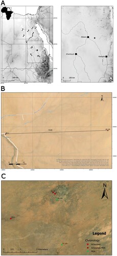
EDAR 134 (N17°68ʹ12ʺ E34°77ʹ66ʺ) was found in the southern part of the largest mining shaft concentration, at 376 masl. The gold miners’ heavy equipment destroyed the top stratigraphic units, exposing a cluster of lithic artifacts in the uppermost part of Unit IIIB (A). The other site (EDAR 155) is located 2.7 km south of EDAR 134 (N17°65ʹ68ʺ E34°77ʹ92ʺ) at 384 masl, next to a smaller concentration of mine shafts (C). The topmost stratigraphic unit was removed entirely, which revealed a concentration of artifacts.
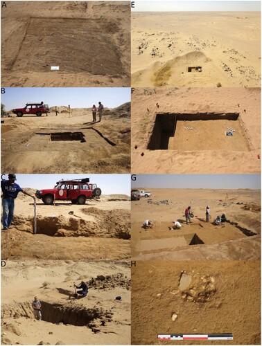
Figure 2. EDAR 134 and 155 sites. A) Surface of opened trench before exploration at site 134, field season 2017. B) Trench at site EDAR 134, season 2018. C) Photo of the profile at site EDAR 134, the remaining top sediment untouched by gold miners, season 2018. D) EDAR 134, site destroyed by gold miners in 2019. E) Aerial photography of site EDAR 155 in 2018. F) Trench I/2018 at site EDAR 155. G) Excavations at site EDAR 155 within trench II/2019. H) Unidirectional core discovered in trench II/2019, EDAR 155.
Methods
Fieldwork
At both sites, trenches were opened where the largest clusters of artifacts were visible on the post-mining surface. The excavation area was then divided into a local grid of 1 × 1 m. At EDAR 134, the trench covered 16 m2. In its central part, two squares were excavated to a depth of 1.6 m (see ). In the remaining squares, excavations reached a depth of ca. 35–40 cm. In 2019, the site was destroyed by a large mining shaft, and the fieldwork was discontinued (D).
Two trenches (I/2017 and II/2018) covering 18 m2 in total were excavated at EDAR 155 (see ). The stratigraphic sequence of the site was revealed in two squares in the southern part of trench I/2017, excavated to the depth of 1 m. The remaining squares in both trenches were stopped at a depth of 30 cm, where sterile sediment without artifacts was reached.
Samples for granulometric analysis and OSL dating were collected from geological cross-sections at both sites. All artifacts larger than 15 mm were plotted using a total station and collected from the surface and during the exploration of sediments. Each was given an ID number, packed separately, and labeled (ID, layer, etc.). Excavated sediments were dry-sieved with a 3 mm mesh. Artifacts extracted from the sieves were grouped within their respective square meters and depths.
Luminescence dating
Optically Stimulated Luminescence (OSL) dating is a technique used to estimate the time since mineral grains were last exposed to sunlight, which is usually assumed to be the burial age of the sediment. After being buried, mineral grains absorb a constant level of radiation from cosmic rays and naturally occurring radioactive isotopes such as U, Th, Rb, and K. In mineral grains such as quartz and feldspar, this radiation results in the progressive accumulation of electrons in traps (areas of positive charge) within the crystal lattice, creating a record of the total dose received. When the minerals are exposed to light or heat, these trapped electrons are released, during which a proportion dissipates energy as light, known as luminescence. The amount of light emitted is proportional to the number of trapped electrons, which is in turn proportional to the total radiation dose received (the natural dose). The equivalent dose (De) is the laboratory estimate of the natural dose and is calculated using the luminescence intensity of the natural sample, usually via comparison with the luminescence intensity in response to a calibrated laboratory radiation dose. When combined with the dose rate received during burial, the time since the last exposure to light or heat can be determined using the equation: Age (kya) = Equivalent dose (Gy) / Dose rate (Gy/kya).
At EDAR 134, six samples were collected spanning both archaeological and archaeologically sterile levels. Only one sample, from Unit IIIB, which contained a lithic assemblage, was collected at site EDAR 155 (). Previous research identified different stratigraphic levels in the EDAR area, of which several were dated using luminescence methods (Ehlert et al. Citation2022; Masojć et al. Citation2019, Citation2021a, Citation2021b; Michalec et al. Citation2021). The results of dating and sediment analysis from EDAR sites 134 and 155 were compared with the data obtained at EDAR sites 7 and 135.
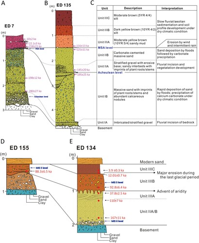
Figure 3. Stratigraphy description at the EDAR sites. A) Site EDAR 7, B) site EDAR 135, C) description and interpretation of stratigraphy units, D) EDAR 155 with the height of OSL sampling marked with a red dot, and E) EDAR 134 with the height of OSL sampling marked with red dots.
Luminescence samples were measured by the Gliwice Absolute Dating Method laboratory (GADAM) (Moska et al. Citation2021), and the data from these measurements was later analyzed at Royal Holloway, University of London. Measurements were performed on a Daybreak Model 2200 reader using a 90Sr/90Y beta source for irradiations. Stimulation was carried out at 125°C for 60 seconds, using blue light emitting diodes. Aliquots were heated at 5°C/s during all heating steps, and a 10 second pause at 125°C prior to optical stimulation was used. The OSL intensity is recorded during the first 1.5 seconds of stimulation with a background signal subtracted. The EDAR samples displayed a rapidly decaying OSL signal. All growth curves were fitted using a saturating exponential plus the linear function. The performance of the SAR procedure was monitored via recycling ratios, and recuperation was calculated to monitor its performance (Murray and Wintle Citation2000, Citation2003). Aliquots not yielding recycling ratios consistent with unity (2σ) or displaying recuperation greater than 5% of the natural signal were rejected.
Radioisotope concentrations for each sample were measured using high-resolution gamma spectrometry (Canberra gamma spectrometers with HPGe detectors). These data imply secular equilibrium in the 238U and 232Th decay series. Beta and gamma dose rates were calculated from the radioisotope concentrations using the conversion factors of Guérin, Mercier, and Adamiec (Citation2011). Beta dose rates were corrected for grain size using the attenuation factors of Guérin and colleagues (Citation2012) and the etch attenuation factor after Bell (Citation1979). A moisture content of 8 ± 3% was assumed for all samples to account for the plausible range of past conditions and humidity changes affecting the samples. Cosmic ray dose rates were calculated based on the altitude, latitude and longitude, present-day burial depth, and overburden density of the sample (Prescott and Hutton Citation1988). Overburden densities of 1.8 g/cm3 were assumed.
The optimal statistical model for determining the equivalent dose was determined after analyzing the degree of skewness, the kurtosis, and the overdispersion of the De distributions following Bailey and Arnold (Citation2006). The Central Age Model (CAM) was found to be appropriate for all samples (Galbraith et al. Citation1999). Abanico plots showing the equivalent dose distribution and the calculated CAM De for each sample are presented in Supplemental Material 1, SM Figure 1. More detailed information regarding sample preparation is presented in Supplemental Material 1.
Lithic studies
All lithic assemblages discovered during the three seasons (2017–2019) of fieldwork carried out at both sites were subjected to techno-typological analyses. Generally, detailed analyses of MSA and Middle Paleolithic assemblages include only artifacts larger than 20 mm (Prévost and Zaidner Citation2020; Schild and Wendorf Citation1977). However, because of the lack of consensus on “miniaturization” in lithic production (Pargeter and Shea Citation2019), we decided to move the threshold down to 15 mm. Smaller specimens were classified as chips (metrical, not technological), and only raw material type was specified for them.
Lithic studies were based on the chaîne opératoire conceptual framework (Pelegrin, Karlin, and Bodu Citation1988; Sellet Citation1993; Shott Citation2003). This approach aims to reconstruct technological behaviors, from raw material procurement to discarding used tools, and studying lithic materials related to respective stages of the operation sequence (Pelegrin, Karlin, and Bodu Citation1988; Shott Citation2003; Tixier Citation2012). Moreover, it allows the analysis of different aspects of the raw material economy at the site. The concept of chaine opératoire has certain limitations and has been criticized by Bar-Yosef and Van Peer (Citation2009), who pointed out its weaknesses: restricting oneself to a rigidly technological framework and over-formalized typological description and emic relevance—the illusion of being able to read the minds of prehistoric knappers.
All the artifacts from both sites (cores, tools, debitage, and waste) were classified according to the syncretic typological list following the categories defined, among others, by Schild and Wendorf (Citation1977) and Van Peer (Citation1992) and applied in previous studies of other lithic assemblages from EDAR sites. Specific features were studied for each artifact group (see Supplemental Material 1 for a list of attributes). The maximum length, width, and thickness of all artifacts over 15 mm were measured with an electronic caliper (0.01 mm resolution). The lengths were measured along the technological axis (see Andrefsky Citation2005). All artifacts were weighed using an electronic scale (0.01 g resolution). Detailed Scar Pattern Analyses were conducted for all the cores whenever the preservation state allowed it. Selected artifacts were photographed and drawn. Conjoining studies of these assemblages have not yet been carried out.
The Levallois method was defined according to the six criteria proposed by Boëda (Citation1993, Citation1995, Citation2014: 1) presence of two asymmetrical convex faces, with the intersection defining a plane; 2) hierarchization of two faces which are related to each other—one produces predetermined products and the other is conceived of as a surface of the striking platform; 3) predetermination and production of convexities on the main flaking surface; 4) the plane of predetermined products is parallel to the plane of intersection of a core; 5) the prepared/faceted striking platform is located perpendicular to the main axis of a core with a proper flaking angle; and, 6) application of hard hammer direct percussion technique in the production of the determined Levallois products. To distinguish the recurrent and preferential Levallois method from the Nubian method, we used the criteria proposed by Usik and colleagues (Citation2013): triangular and subtriangular shape of cores, distal ridge preparation, and facetted and dihedral striking platforms. Spatial analysis, including scatter of objects in terms of artifact type, weight, and Kernel density (bandwidth = 0.25), was conducted using QGIS (3.34 Lima version) software.
Usewear analysis
The sample of 20 artifacts selected for usewear analysis included only flake tools with at least one intact, functional working edge. All came from EDAR 155. Artifacts with heavily rounded or micro-chipped edges and ridges were excluded. The study was conducted in the laboratory of the Institute of Archaeology, University of Wroclaw. The artifacts were cleaned for 2–5 minutes in an ultrasonic bath and observed under a NIKON Eclipse LV 100 microscope with magnifications between 200x and 500x. The traces were documented with the same microscope. Image focus was enhanced using picture stacking.
The physical proprieties of quartz, especially its high reflectivity and irregularity in trace formation, make usewear analysis quite challenging. Traces appear on small areas, more frequently on crystals and elevated topography parts (Clemente Conte et al. Citation2015, 64–65); Leipus Citation2014, 230–233). Additionally, features typical of usewear and post-depositional alterations may co-occur on different parts of one tool. Therefore, careful observation of each edge under magnifications between 200x and 500x is required to observe specific surface features (Lemorini et al. Citation2014; Taipale Citation2012, 94).
Results
Stratigraphy
Multiple sedimentary sequences ranging from 1–5 m in thickness have been excavated in the EDAR area (Masojć et al. Citation2019, Citation2021b). Detailed sedimentary profiles were obtained from sites EDAR 7 and EDAR 135 (Ehlert et al. Citation2022; Masojć et al. Citation2021a; Michalec et al. Citation2021), and these provide a stratigraphic context for EDAR 134 and EDAR 155 (see ). Generally, the sedimentary deposits at these sites can be divided into three units (I–III) bounded by fluvial or aeolian erosion surfaces. Unit I consists of stratified and imbricated gravel in the lower part (IA) and massive sand with abundant calcium carbonate nodules in the upper part (IB). Unit II overlies Unit I with an unconformity-boundary and comprises planar- to cross-stratified gravel interbedded with sandy deposits with imprints of plant roots/stems in the lower part (Unit IIA) and carbonate-cemented massive sand in the upper part (Unit IIB). Unit III comprises yellow to dark brown silt and sandy mud with subtly different grain sizes. It is underlain by a thin and continuous gravel layer, representing a desert pavement which resulted from the removal of sand and dust by wind and intermittent rain. At EDAR 7, Unit III directly overlies Unit I, suggesting the complete removal of Unit II by deflation or other wind erosion processes.
The lower two units (Units I and II) are interpreted to have resulted from fluvial incision of the bedrock or the earlier sedimentary deposits followed by sand deposition by floods and subsequent calcium carbonate precipitation. The predominance of fluvial features and the imprints of plant roots/stems in these units suggest that the climatic conditions were relatively wet during the Acheulean and the MSA. Afterwards, the area was subject to aeolian erosion, and a desert pavement formed, probably because of the advent of aridity. Deposition of the finer-grained Unit III occurred during a period of reduced clastic sediment input by aeolian and rare overland flow processes, followed by soil profile development under semi-arid climatic conditions. In general, sedimentary facies changes of EDAR are characterized by both fluvial and aeolian processes, with unconformity boundaries indicating an erosional episode or transitional period. This is demonstrated by periodic transitions from a stream channel-dominated alluvial plain in the lower part to an arid savanna or grassland in the upper part.
Very thin (< 1 m) sedimentary deposits are preserved at EDAR 155 (see ), making it difficult to define and correlate the depositional units. However, the dark yellow-brown sand upon the gravelly sand and bedrock is inferred to correlate with Unit IIIB of the EDAR 135 site. At EDAR 134, carbonate-cemented massive sand and gravel occur upon the weathered bedrock. An OSL age from the deposit suggests that it is coeval with Units IIA and IIB. The overlying deposits of dark yellow-brown and brown silty sands have textures and colors similar to those of Units IIIB and IIIC, respectively. Unit IIIA is presumed to be intercalated between Unit IIA/B and Unit IIIB/C but is poorly identified by sedimentary features.
OSL dating
Dose rates were calculated using the DRAC online calculator (Durcan, King, and Duller Citation2015) which, in combination with CAM De values, was also used to calculate ages ().
Table 1. Dose rates, equivalent doses, and ages of the EDAR samples.
For EDAR 134, dating results confirm the stratigraphic situation associated with strong erosion of sediments in the late Pleistocene (see , ). Sample EDAR_134_S1_2019 yielded an age of 12 ± 0.7 kya and was collected in the bottom part of Unit IIIA. However, another sample (EDAR-134-S1) was taken from a depth of approximately 40 cm within the same stratigraphic unit and yielded a younger age of 3.9 ± 0.3 kya. Overdispersion of aliquots of this sample is relatively high, possibly indicating bioturbation, though it is equally possible that Unit IIIC accumulated over a considerable period of time.
Sample EDAR-155-S1, collected below the archaeological horizon in Unit IIIB, was dated to 88.3 ± 6.5 kya (see ). Chronologically similar dating results (92.8 ± 6.4 kya) were also obtained for sample EDAR-134-S2 from the same stratigraphic unit (IIIB) at EDAR 134, which is also below the location of the lithic assemblage. Moreover, the dating results of sample EDAR-134-S4, taken from the bottom of Unit IIA/B, where three artifacts were discovered, confirm older traces of human presence in MIS6.
The age of sample EDAR134-S3, collected from the uppermost part of Unit IIIA, yields a younger age (37.8 ± 2.5 kya) than the underlying sample EDAR134-S2 (Unit IIIB, 92.8 ± 6.4 kya), EDAR134-S4 (top of Unit IIA/B, 167 ± 11 kya), and basal ages for Unit IIIA at sites EDAR 7 (158 ± 15 kya) and 135 (116 ± 13 kya, see ) (Ehlert et al. Citation2022; Masojć et al. Citation2021a, Citation2021b; Michalec et al. Citation2021). Sample EDAR134-S3 was taken from the layer affected by desiccation cracks (Unit IIIA), which extended from the layer above. These cracks contain sediment from the overlying layer and may have caused significant mixing. Moreover, cracks are often used by vegetation for roots and infiltrating water, potentially resulting in the inclusion of younger intrusive grains in the lower layers. Therefore, it is possible that the equivalent dose for this sample is an underestimate of the burial dose for the material of interest (i.e. Unit IIIA), as the measurements were conducted on small aliquots containing hundreds of grains, some of which are younger than and not derived from Unit IIIA. Consequently, we do not regard the age for sample EDAR134-S3 as indicative of the age for Unit IIIA.
EDAR 134 lithic assemblage
The lithic assemblage includes 379 artifacts with a combined weight exceeding 5 kg (). Of these, 233 were found and plotted in the squares, while 146 came from the sieves. Debitage and waste—flakes, blades, chips, and debris—were the most numerous artifact group (n = 351). Thirteen of them were identified as technical products from Levallois core reduction, mainly debordant flakes. Retouched tools (n = 19) were the next most numerous category, followed by cores and precores (n = 8) (see ).
Table 2. EDAR 134, structure of lithic assemblage—number and weight of artifact classes by raw materials.
Preservation and spatial distribution
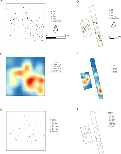
Although most artifacts (69.8%) were preserved completely, as much as 95% of the assemblage bears traces of considerable abrasion. This suggests a strong influence of post-depositional processes, such as wind erosion, without much influence of ones that could result in high fragmentation rates. Most artifacts were recorded in the dark yellow-brown sandy dust sediments of Unit IIIB (see , ). A horizontal cross-section reveals the distribution of the objects becomes less dense along the west-east axis (see ). As the relative height difference between the artifacts is up to ca. 30 cm, they might have been deposited on the surface of a gentle slope.
Figure 4. Spatial analysis results for vertical position of assemblage. A) EDAR 134 and B) EDAR 155.
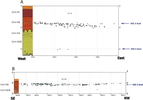
The results of the vertical Kernel density analysis revealed two clusters: a larger one in the southeastern part of the trench and a smaller one in the northwestern part (). All artifact categories are present in both concentrations (see ). The analysis of the distribution of objects relative to their weight does not suggest post-depositional material sorting. The partial, horizontal, and vertical redeposition probably resulted from floating water and soil expansion and shrinkage during seasonal rainfalls. Besides that, the artifacts probably remained on the surface for a long time, which allowed aeolian erosion to transform their surfaces to such a degree that in some cases the negatives are barely visible. Considering that and the OSL dating results, it should be assumed that the deposition of the assemblage occurred in the warm period with strong seasonal rainfall—MIS 5c. Then, from MIS 5b–MIS 2, during dry periods with strong wind erosion, the artifacts remained exposed on the surface.
Figure 5. Spatial analysis results for EDAR 134 and 155. A) Spatial distribution by artifact type, EDAR 134; B) distribution of artifacts by weight, EDAR 134; C) Kernel density, EDAR 134; D) spatial distribution by artifact type, EDAR 155; E) distribution of artifacts by weight, EDAR 155; and, F) Kernel density, EDAR 155.
Raw material
Lithic production was based on local raw materials, mainly rhyolite (n = 280) and quartz (n = 98); only one artifact was made from sandstone (see ). Pebbles and cobbles occurring on the surface were the most commonly exploited raw material form. They came from fragments of bedrock (consisting mainly of dacite and rhyolite intruded by quartz dykes) that were shaped and modified during fluvial transport in humid climatic conditions, as well as aeolian processes during dry climatic periods.
Cores
Eight cores were discovered—six from rhyolite and two from quartz. A cobble with a single negative on one of the faces was classified as a precore (Table SM1, Supplemental Material 1). Two rhyolite cores represent different variants of the predetermined method—recurrent Levallois and Nubian Levallois (A). The Nubian core, triangular and with a faceted platform, is characterized by bilateral preparation (opposing negatives, perpendicular to the main axis) of both the flaking surface and the second face (see A). Such features are those of the type 2 Nubian (Van Peer Citation1998), according to Usik and colleagues (Citation2013). Apart from that, the flaking surface displays the evidence of a last, unsuccessful attempt at making a Nubian point: a negative with a hinge termination obliterating the middle of the flaking surface. The angle between core surfaces is 60–70 degrees. The other predetermined core is the Levallois recurrent unidirectional type (D). The main flaking surface and lower face display centripetal preparation negatives. The former displays three leading negatives resulting from the effort to obtain Levallois flakes, originating in the main faceted platform of the core.
Figure 6. EDAR 134, cores. A) Nubian II Levallois, B–C) discoidal, D) recurrent Levallois, and E) multidirectional; rhyolite. Photos: M. Jórdeczka.
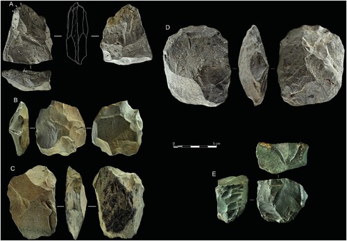
The next two rhyolite cores are classic discoidal with centripetal negatives (B–C). The remaining three forms result from the use of opportunistic single-platform (n = 1) and multi-platform (n = 2) reduction methods (see ). One of the multidirectional cores, made from a quartz pebble, shows traces of a simple change of reduction surfaces without their prior preparation. The other (made from rhyolite) employed a different reduction strategy (E). The negatives from the initial flaking phases suggest that at this stage, a method similar to the one seen on the previous core was employed: multidirectional reduction of unprepared surfaces and free-hand direct knapping. The strategy then changed to bipolar on an anvil, as evidenced by the chipping and impact traces on the core’s surface.
The mean sizes of the cores are 70.9 × 58.9 × 39.2 mm. The medians do not differ substantially, which suggests the absence of a wide range of sizes and excessive values in the set (Table SM7, Supplemental Material 1). The two smallest cores were quartz, and their sizes suggest the use of small pebbles in flake production. The sizes of predetermined and discoidal cores based on rhyolite cobbles suggest that the selection of the raw material at the early stage was aimed at finding the appropriate volume necessary to successfully execute these methods.
Debitage and waste
This category consists of 351 artifacts: 143 flakes, 12 blades, 13 Levallois core trimming elements, and six Levallois flakes, as well as 154 chips and 30 debris pieces (Table SM2, Supplemental Material 1). Most artifacts were made from rhyolite, including all flakes with metric features fitting the blade category. Only 28 flakes were made from quartz; the remaining 114 were rhyolite (see Table SM2, Supplemental Material 1). Almost 70% of all flakes were fully preserved. Most of them (76.7%) have less than 50% of the natural surface on the upper side—they were removed during the final stages of core reduction. The two most frequent directions of dorsal negatives are unidirectional (45.1%) and multidirectional (19.7%); two-directional perpendicular (8.5%) and opposite (1.4%) patterns are less common. Dorsal negatives of the remaining 25.3% were too strongly abraded. Flakes with a natural and plain platform were the most numerous, while the dihedral and faceted ones were less frequent.
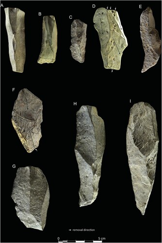
The technical products (n = 13) of Levallois core reduction are debordant flakes, controlling and changing the convexity of the distal and lateral parts of the cores (). They are characterized by prepared platforms and dorsal sides with original core preparation scars partially removed by the detachment of a final product. Six debordant flakes meet the metrical blade criterium (2:1 length to width ratio). All the blades have regular unidirectional dorsal negatives (see ). Two of them have a facetted platform, one plain. Platforms of all the remaining blades are unidentified due to the degree of abrasion. Of six Levallois flakes, four were fragments and only two were preserved completely; all had faceted platforms. Based on the triangular shape of its distal part, one of them was described as a Levallois point. Perpendicular (n = 2) and centripetal (n = 3) dorsal scar directions dominate, as only one flake had unidirectional negatives.
Figure 7. EDAR 134, debitage. A–C) Blades and D–G) debordant flakes and blades; rhyolite. Photos: M. Jórdeczka.
Retouched tools
Nineteen tools were discovered—13 complete ones and six fragments (Table SM3, Supplemental Material 1; ). Ten were made from quartz, and the remaining ones were from rhyolite. Most tools (n = 18) display technological features of domestic tools used mainly within the encampment and not as hunting weapon elements: five denticulates, three endscrapers, three sidescrapers, two notched tools, and one retouched Levallois flake, as well as one blade and five flakes with simple edge modification.
Figure 8. EDAR 134, tools. A) Unretouched and B) retouched Levallois products, C) denticulate, D–F) endscrapers, G, K) retouched flakes, and H–J) sidescrapers; A–F) rhyolite and H–K) quartz. Photos: M. Jórdeczka.
The tools were made mainly from flakes without much natural surface on the dorsal side—less than 25% (n = 15) and 50% (n = 2). Most of them come from multidirectional (n = 8) cores; unidirectional (n = 2) and two-directional perpendicular negatives (n = 2) were also recorded. In two cases, dorsal sides were damaged beyond recognition. Five tools had their platforms missing; among the remaining ones, the most frequent type was plain (n = 9), while natural and prepared ones were less frequent, and only one was punctiform.
EDAR 155 Lithic assemblage
The EDAR 155 assemblage consists of 1111 specimens (); 546 were found in the squares, and 565 were found while sieving. The combined weight of the whole assemblage exceeds 8 kg (see ). Again, debitage and waste dominate. Among the former, flakes (n = 352) were the most common, followed by blades (n = 7) and bladelets (n = 2) (see ). The latter are mostly chips (n = 616), with 52 debris pieces. Apart from that, nine technical products from core preparation, nine Levallois flakes, and 31 retouched tools were classified.
Table 3. EDAR 155, structure of lithic assemblage—number and weight of artifact classes by raw materials.
Preservation and spatial distribution
77.7% of the artifacts were preserved completely. Surface condition is diverse: 47% had fresh surfaces with clearly visible negatives, while 53% were abraded to some degree. The artifacts were situated mainly within the top of a layer of dark-yellow sands with a fine fraction of gravel (Unit IIIB). In the vertical projection, they formed a 20 cm thick concentration (see , B).
The horizontal projection reveals the absence of artifacts in the northern part of the 10 × 1 m (eastern) trench (see ). The results of Kernel density analysis show two clusters preserved within the site: one in the southern part of the eastern trench and the other mainly in the northeastern part of the western (4 × 2 m) trench, with some possible remains in the northern part of the eastern trench. The northwestern cluster contains a significant number of cores and retouched tools, which are hardly present in the other one. Weight class analysis revealed no post-depositional material sorting. These results indicate that post-depositional processes impacted mostly artifact surfaces, which show abrasion caused by aeolian processes. However, they did not cause significant spatial redeposition. This confirms the fact that they were found in the original position of their deposition, perhaps after minimal vertical displacement.
Raw material
Most artifacts at the site were made from local raw materials (see ): quartz (n = 871), rhyolite (n = 223), and quarzitic sandstone (n = 13); only four were made of Hudi chert, not found in the near vicinity of the site. Surface prospection revealed Hudi chert outcrops (site EDAR 1) near the Ad-Daburra village on the Atbara riverbank, ca. 70 km from EDAR 155 (see B). Such a long distance seems to have prevented this raw material from being regularly used at the site, restricting it to single precores or raw material lumps.
Cores
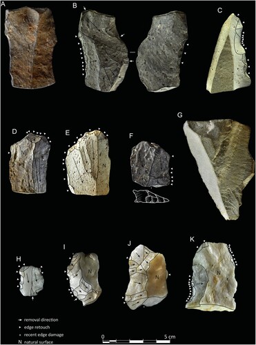
This category includes 27 cores and six precores, most made of quartz (n = 25) (Table SM4, Supplemental Material 1; ). The majority (n = 30) are preserved in a complete form; only three were fragmented. Most were abandoned at the late stages of reduction. Three such cores were classified as residual due to the insufficient block volume preventing further reduction. Forms connected with the use of opportunistic production methods predominate in the assemblage: unidirectional cores (n = 8) and multiplatform cores (n = 11) (D, A). The unidirectional cores mainly have platforms prepared with one removal or are completely natural. Technological features of two cores meet the criteria for discoidal cores, including the absence of hierarchization between two flaking surfaces and centripetal scar directions (C). Another core is bipolar, showing opposing negatives with splintered scarring on the flaking surfaces, along with Hertzian cones on one of the platforms (D).
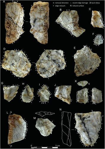
Figure 9. EDAR 155, cores. A) Recurrent Levallois, B) multiplatform core, C) discoidal, and D) unidirectional; A) Hudi chert, B–C) quartz, and D) rhyolite. Photos: M. Jórdeczka.
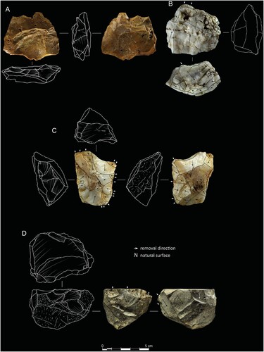
Figure 10. EDAR 155. A) Unidirectional core, B) blade, C–E) Levallois flakes, F) denticulate, G) retouched Levallois flake, and H) multidirectional flake; all rhyolite. Photos: M. Jórdeczka.
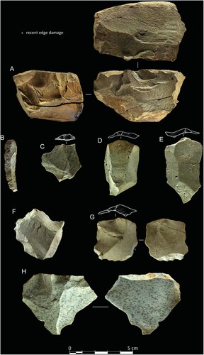
Two cores represent different Levallois methods of production. The first one, made of Hudi chert, is recurrent with centripetal preparation of both surfaces and one main, hinge-terminated negative was created by detaching a Levallois product (A). Main flaking surface preparation scars are visible in the proximal part near the platform and partly in the distal part; the rest is left natural and unprepared. The platform is unidirectionally faceted. The other core is centripetal recurrent and made of rhyolite. The scar pattern of the flaking surface shows two series of Levallois product negatives. The two main faceted platforms are located on the opposing sides of the core. The second face is centripetally prepared with ca. 50% of the natural surface left intact.
Mean core sizes are 45 × 42.2 × 31.8 mm (Table SM8, Supplemental Material 1). Only three cores have maximum dimensions exceeding 60 mm. The medians and means for the maximum sizes are similar, which testifies to the absence of considerably excessive values in the assemblage. The smallest core measures 17.8 × 20.7 × 9.3 mm. This size range proves that in most cases, raw material of small size was used, e.g. cobbles or pebbles. Additionally, the cores were normally abandoned at a late use stage, with much of their original volume exploited. In this case, the apparent miniaturization seems to result from economic issues and the raw material availability of a particular volume rather than intentional technological behavior.
Debitage and waste
The EDAR 155 assemblage includes 352 flakes (230 quartz, 110 rhyolite, 10 quarzitic sandstone, and two Hudi chert), 616 chips (72 rhyolite, 543 quartz, and one Hudi chert), and 52 debris (including 15 rhyolite) (Table SM5, Supplemental Material 1). Most flakes were preserved completely (n = 271; 81 fragmented) and have less than 50% of their natural surface on the dorsal face (n = 231), which means that they come from late core reduction stages (see Table SM5, Supplemental Material 1). Only 17 flakes have more than 50% of the natural surface, and 66 are completely cortical; 36 remained undetermined due to surface damage. Four different types of dorsal patterns occurred (see Table SM5, Supplemental Material 1): unidirectional (n = 168), perpendicular (n = 44), multidirectional (n = 44), and opposite (n = 10). The most frequent platform types are plain (n = 146) and cortical (n = 111), while dihedral, linear, punctiform, and faceted ones were much less common (see Table SM5, Supplemental Material 1).
Nine flakes were classified as core trimming elements (see ). Four of them bear the features typical of primary debordant flakes—multidirectional scars of a flaking surface preparation, as well as faceted and plain platforms. The other five are secondary debordant flakes with perpendicular dorsal negatives created during the preparation of the flaking surface and detaching of preferential flakes; two with plain and three with faceted platforms. The last category of core reduction products is represented by nine Levallois flakes: seven rhyolite and two quartz (see ). Typologically, six of them are Levallois flakes, one is a Levallois point, and two are Nubian points (a complete one and a fragment), all with faceted platforms. Their dorsal scar patterns are centripetal (n = 4), unidirectional (n = 2), and perpendicular (n = 1).
Retouched tools
As with the remaining artifact groups, the retouched tools were predominantly made of quartz (n = 28), with the addition of rhyolite (n = 2) and quartzite sandstone (n = 1) (Table SM6, Supplemental Material 1; ). Except for one retouched Levallois flake, all these retouched tools can be associated with various simple domestic activities within the encampment: flakes with simple retouch (n = 12), denticulates (n = 4), sidescrapers (n = 6), endscrapers (n = 5), perforators (n = 3), combined tools (n = 2), and one unidentified tool fragment. Most tools (n = 21) were made on flakes from advanced core reduction stages with less than 50% dorsal cortex; only two have more than 50% of the natural surface and three are fully cortical (see Table SM6, Supplemental Material 1). The retouched tool blanks have unidirectional (n = 14), multidirectional (n = 5), perpendicular (n = 6), and opposite (n = 3) scar patterns. Six platform types have been observed on tools: plain (n = 9), cortex (n = 5), dihedral (n = 4), faceted (n = 3), punctiform (n = 2), and one linear.
Figure 11. EDAR 155, tools. A, C) Denticulates, B, D, H) sidescrapers, E, I) perforators, F) endscraper, G, J) retouched flakes, K–L) composite tools, M) Levallois flake, and N) Nubian Levallois flakes; all quartz. Photos: M. Jórdeczka.
Usewear analysis
Macroscopic examination of 10 sample artifacts revealed slight to heavy rounding of at least one working edge. On three, small, irregular, overlapping negatives were observed; these could be the first indicators of use for cutting. A multitude of traces was discovered in microscale. Unfortunately, the vast majority of them may be attributed to post-depositional processes. Two types of polish appeared on otherwise dull surfaces. The first type, covering larger areas, was rough and matt (A). The other manifested itself as scattered, brighter, more translucent, and smoother patches (B). Other micro-traces included short, crisscrossing sleeks and striations of varying depth. Numerous impact pits were visible, especially on tool edges and ridges. In many cases, they formed large concentrations. A series of small cracks and chips could also be observed. All the described traces may be linked to aeolian abrasion, suggesting that the analyzed artifacts were temporarily uncovered and exposed to sandblasting. This, together with tumbling, would have caused fractures, cracks, impact pits, and irregular scratching of the surface (Knutsson and Lindé Citation1990).
Figure 12. EDAR 155. A–B) Features interpreted as post-depositional wear: irregular striations and patches of polish and C–D) possible usewear mixed with post-depositional damage. Noticeable edge rounding, some short perpendicular sleeks; visible weak polish (marked by arrows).
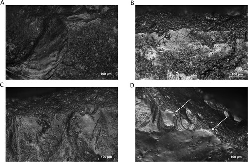
Due to heavy post-depositional alterations, it was almost impossible to identify traces related to specific tasks. Indicators of possible use—regular edge rounding caused by overlapping microfractures—were identified in two cases. This, together with several perpendicular striations, could hint at the use for scraping (C–D). Such interpretation is by no means certain, as similar patterns could be created by post-depositional wear (Taipale Citation2012, figs. 2.1, 2.2).
Discussion
A strong connection between human settlement and changing environmental conditions during MIS5 in the EDAR area is visible in the data obtained at the sites. This period is characterized by climate variability and the occurrence of several humid, semi-humid, and semi-arid periods (Williams Citation2020; Williams et al. Citation2015). Environmental data confirm the climatic conditions referred to as the Green Sahara, where the modern desert was a grassland/savanna biome with numerous lakes and seasonal watercourses (Ait Brahim et al. Citation2023; Drake et al. Citation2011, Citation2022)
The occurrence of a warm and humid period during MIS 5e associated with Sapropel Event 5 was confirmed by correlating marine and Nile basin sediment data (Williams Citation2020; Williams et al. Citation2015). Similarly, the analysis of Wadi Midauwara silts in the Kharga Oasis confirmed the presence of a lake in the MIS 5e period, around which human settlements existed (Kieniewicz and Smith Citation2007; Smith et al. Citation2007). One of the EDAR sites fits in that timeframe—the younger archaeological horizon from EDAR 135 was discovered in sand and gravel deposited during strong erosion episodes occurring between sedimentation periods at the turn of MIS 6 and MIS 5e (Ehlert et al. Citation2022; Masojć et al. Citation2021b).
The dating of sediments from EDAR 134 and 155 indicate human presence at the turn of MIS 5c and 5b. MIS 5c was a relatively warm and humid period, which is confirmed by the studies of the middle reaches of the Atbara River, where paleosol remains dated to 98 ± 10 and 90 ± 10 kya were discovered in Khashm El Ghirba 2. Their grain size and chemical composition show conditions corresponding to a sub-humid and semi-arid climate (Mohammednoor et al. Citation2023). Further confirmation of humid or semi-arid conditions in this period is found in lake sediments from Bir Sahara and Bir Tarfawi (Schild, Hill, and Bluszcz Citation2020), as well as in studies of Nile Valley sediments (Williams et al. Citation2015). It should be noted that compared to the MIS 5e and MIS 5a stages, MIS 5c is characterized by much lower humidity (Schild, Hill, and Bluszcz Citation2020; Williams Citation2020; Williams et al. Citation2015). It cannot be ruled out that the deposition of the lithic assemblage occurred during the period when the EDAR area was covered with green savanna. Macro- and microscopic observations recorded a large share of post-depositional traces and abrasion visible on the surfaces of the stone artifacts. This indicates that the assemblage remained on the surface for a long time, which resulted in the objects being exposed to post-depositional processes, mainly aeolian ones, occurring during dry periods such as MIS5b (Schild, Hill, and Bluszcz Citation2020; Williams et al. Citation2015).
Technological behaviors and cultural attribution
The data obtained so far does not allow us to determine unequivocally which subsistence-settlement model, e.g. foragers or collectors as proposed by Binford (Citation1980), was adopted by the communities occupying the EDAR area. Mobility models of hunter-gatherer societies are influenced by many factors: environmental and climatic conditions, group size, subsistence strategy, or access to resources (Binford Citation1980; Grove et al. Citation2023; Johnson Citation2014). Two main site formation processes that influence data acquisition should also be considered: cultural and noncultural (environmental) formation processes (Schiffer Citation2010).
Despite similar dating, there is no certainty that the same group settled both EDAR 134 and 155, either simultaneously or at a similar time. There are, however, several important aspects differentiating both assemblages. Firstly, a much smaller number of artifacts was discovered at EDAR 134. Secondly, the percentage of retouched tools is higher on that site. Thirdly, there are artifacts made of non-local Hudi chert raw at EDAR 155. Based on that, EDAR 155 can be considered as a part of a larger network of seasonal camps and lithic workshops. This seasonality should probably be associated with favorable environmental conditions during the rainy season, when it was possible to hunt the fauna that migrated to savanna areas away from the permanent riverbeds, e.g. the Atbara River. According to the models proposed by Binford (Citation1980), EDAR 134 should be considered a cache or station, where special tasks were performed by small groups. In this case, this task might have been establishing a small outpost near an easily accessible outcrop of high-quality rhyolite.
Both the EDAR 134 and 155 assemblages are characterized by the predominance of one local raw material, i.e. quartz at EDAR 155 and rhyolite at EDAR 134. One of the behavioral innovations of the MSA is the long-range transport of raw materials (McBrearty and Brooks Citation2000; Scerri and Will Citation2023). The four Hudi chert artifacts from EDAR 155, probably brought from the EDAR 1 outcrop near Ad Daburra on the bank of the Atbara River ca. 70 km away, could be evidence of such behavior (see B). Of course, without XRF analyses, we cannot state unequivocally that Hudi chert came from this particular outcrop. Either way, it seems that the long distance from its sources prevented a more regular use of this raw material. This is evident in the MIS 6/5e EDAR 135 assemblage, where only quartz and rhyolite were found (Ehlert et al. Citation2022).
The diversity of the properties of raw materials occurring in the EDAR area was explored during an experiment involving large cutting tools and large flake production (Masojć et al. Citation2021a). This may be the cause of intentional raw material selectivity according to various production methods. It seems that, due to its properties, rhyolite was more willingly used when the Levallois method was applied—most of the Levallois cores and their reduction products were made of this raw material.
Quartz has the tendency to shatter during detachment, which makes controlling and maintaining the expected shape of the product problematic (Pargeter and De La Peña Citation2017). This raw material was mainly used in opportunistic core reduction methods aimed at obtaining as many working edges as possible while using all block volume: unidirectional, multidirectional, and discoidal. It should also be noted that such a technological orientation is reflected in the high frequency of simple domestic tools (retouched flakes, notches, scrapers, denticulates, etc.), used for various activities related to working with organic raw materials (bones and wood) and butchering (Ehlert et al. Citation2022).
Insufficient data on the chronological range of individual complexes makes relating the assemblages from EDAR 134 and 155 to technological complexes known from northeastern Africa somewhat difficult (Garcea Citation2020a; Leplongeon Citation2021, Citation2022; Masojć Citation2021). Therefore, any attempts at placing them in the broader context of the local cultural mosaic must focus on their techno-typological features. The Levallois, discoidal, and opportunistic core reduction methods mentioned above are not distinctive features—they are common in various technological units of the MSA in northeastern Africa (Garcea Citation2020a; Leplongeon Citation2021, Citation2022; Masojć Citation2021; Scerri and Spinapolice Citation2019; Van Peer Citation2016). Therefore, attention should be paid to the individual Nubian Levallois cores and Nubian points from EDAR 134 and 155. These artifacts are the fossile directeur for the broadly defined Nubian complex (Van Peer Citation1998). The nature of the Nubian complex, as well as the Nubian Levallois technology itself, occurring not only in northeastern but also in southern Africa and the Arabian Peninsula, are hotly debated issues in the literature on the subject (Blinkhorn et al. Citation2021; Hallinan and Marks Citation2023; Hallinan et al. Citation2022; Masojć et al. Citation2017; Rose et al. Citation2011; Usik et al. Citation2013; Van Peer Citation1998). The Nubian complex was originally defined by Van Peer (Citation1998) and includes local technological units previously identified in Sudan and Egypt (Van Peer Citation1998; Van Peer and Vermeersch Citation2000), including the Denticulate Mousterian (Marks Citation1968a), Khormusan (Marks Citation1968b), and Nubian Middle Paleolithic (Guichard and Guichard Citation1965). So far, two development phases of this complex have been distinguished: Early Nubian, characterized by bifacial foliates and predominance of Nubian Levallois cores, and Late Nubian, with Nubian core reduction methods (type I) focused on the production of Nubian points and no bifacial foliates (Van Peer Citation1998, Citation2016; Van Peer and Vermeersch Citation2000). Nubian sites in the Nile Valley are found both in the main area of floodplain edges and deep in today’s desert; the latter are interpreted as sites associated with special activities (Van Peer Citation1998, Citation2001, Citation2016).
Only a few Nubian sites from Egypt and Sudan have had the ages of their sediments determined so far (Garcea Citation2020a; Leplongeon Citation2021, Citation2022; Masojć Citation2021). Three key sites from Egypt should be mentioned. Taramsa 1 (Van Peer, Vermeersch, and Paulissen Citation2010; Vermeersch Citation2023b), with two Nubian phases (II and III), is OSL dated to ca. 103 and 69 kya (Vermeersch Citation2023b). Phase II is a small cluster of artifacts originating during the production of Nubian Levallois points and blades (Vermeersch Citation2023b). The technological features of Phase III, discovered above a human burial, are strictly related to type I Nubian Levallois point production (Van Peer, Vermeersch, and Paulissen Citation2010; Vermeersch Citation2023b). The next two sites are Sodemein Cave and Bir Tarfawi (Hill Citation1993; Vermeersch Citation2023a). At the Sodemein Cave site, horizon six was associated with the Nubian complex (Vermeersch Citation2023a). Luminescence dating of the sediments indicates a chronological range from ca. 87–121 kya (Vermeersch Citation2023a). The techno-typological features of the lithic assemblage from this level indicate a large share of Levallois and Nubian cores (Vermeersch Citation2023a). The Nubian assemblage from the Bir Tarfawi E-87-3 site is associated with a MIS5a lake (Hill Citation1993).
There are two important Sudanese Nubian complex sites: BP177 and Sai Island 8-B-11 (Masojć Citation2018; Masojć et al. Citation2017; Van Peer Citation2023; Van Peer, Rots, and Vroomans Citation2004; Van Peer et al. Citation2003). At BP 177, two archaeological horizons related to this complex (I and II) were discovered on the top of a hill in the Bayuda Desert (Masojć Citation2018; Masojć et al. Citation2017). The assemblages show a large share of classic Levallois cores, along with the Nubian ones. Additionally, numerous bifacial foliates were recorded within horizon I at the site. The dating is younger than the previously mentioned sites: horizon I = < 24 kya, horizon II = > 60 kya (Masojć et al. Citation2017). In the case of Sai Island, the youngest horizon was discovered within a layer dated to ca. 40–25 kya (Van Peer Citation2023). This assemblage was assigned to the Khormusan—a regional unit strongly associated with the Nubian complex (Van Peer Citation2023; Van Peer, Rots, and Vroomans Citation2004)—and characterized by the exclusive use of quartz and the presence of type I Nubian cores and numerous bifacial foliates (Van Peer Citation2023).
All the examples above show that defining the Nubian complex is not an easy task. The dating of the youngest horizons from Sai Island and BP 177 indicate that it lasted much longer, beyond MIS5 (Masojć et al. Citation2017; Van Peer Citation1998, Citation2023). The techno-typological picture is also very complex, with the two main components being the Nubian Levallois core reduction method and foliate points. The latter were not discovered at EDAR 134 and 155, while the former do not have a large share in the assemblages. Additionally, unlike in Sodemein Cave (Vermeersch Citation2023a), there is no clear tendency to produce blades and points using the classic Levallois and Nubian Levallois methods, even though some metrical blades were found (Bar-Yosef and Kuhn Citation1999).
The Sangoan or Sangoan-Lupemban is another technological unit of the northeastern African MSA (Van Peer Citation2016). It was first described in sub-Saharan Africa (McBrearty Citation1988; Taylor Citation2016, Citation2022). Besides Levallois and discoidal cores, it is defined by characteristic core-axe tools: plano-convex, most often bifacial, with one or two opposed working edges (Clark and Kleindienst Citation2001; Van Peer Citation2016) The key Sangoan reference site is Sai Island 8-B-11, dated from MIS 7–MIS 5 (Van Peer Citation2023; Van Peer, Rots, and Vroomans Citation2004; Van Peer et al. Citation2003). The techno-typological features of the assemblages indicate that production was focused on core-axes and foliate points, as well as blanks using classic Levallois and Nubian Levallois methods (Van Peer Citation2023; Van Peer, Rots, and Vroomans Citation2004). In addition, a fragment of a lanceolate point was discovered within horizon III (Van Peer Citation2023).
The Sangoan-Lupemban complex has also been associated with four stratigraphic units at the Khor Abu Anga site in Sudan (Carlson Citation2015; Nassr and Carlson Citation2023). Like on Sai Island, numerous core-axe tools, as well as lanceolate and foliate points, were discovered there, along with a large share of Levallois points and classic and Nubian Levallois cores. No techno-typological elements (core-axes and lanceolate and foliates points) that would justify connecting them with the Sangoan-Lupemban were present in EDAR 134 and 155.
Furthermore, it seems that the structure of both the EDAR 134 and 155 assemblages do not fit the technological features defined for the Aterian (Garcea Citation2020b; Scerri Citation2013a). This complex is characterized by tanged points (Garcea Citation2020b; Scerri Citation2013a, Citation2013b), small Levallois and discoidal cores (Garcea Citation2020b; Spinapolice and Garcea Citation2013), and bifacial foliates and lanceolate points (Garcea Citation2020b). Aterian sites occur mainly outside the Nile Valley, e.g. in the Western Desert in Egypt (Kleindienst, Smith, and Adelsberger Citation2009; Schild and Wendorf Citation1993). The only site recorded within the valley is Wadi Kubbanyia (Schild and Wendorf Citation1989). The chronological framework for the Aterian in northeastern Africa, assuming the dating from the vicinity of the Kharga oasis, can be presumed to be MIS 5–3 (Kleindienst, Smith, and Adelsberger Citation2009; Scerri Citation2013a; Smith et al. Citation2004).
Although most of the non-diagnostic MSA sites in the eastern Sahara region come from the surface (Bicho, Haws, and Honegger Citation2020; Leplongeon, Bailly, and Graff Citation2024; Scerri and Spinapolice Citation2019), some of them have been discovered in stratigraphic contexts (Garcea Citation2020a; Leplongeon Citation2021; Masojć Citation2021). Both sites presented in this article do not fit into the technological picture of the complexes previously defined in northeastern Africa. The younger horizon from EDAR 135, OSL dated to MIS 5e and containing both recurrent and preferential Levallois and opportunistically reduced single and multiplatform cores, as well as simple retouched tools (retouched flakes, denticulates, and scrapers), is very similar in this regard (Ehlert et al. Citation2022). Another Sudanese site which can be associated with a general/non-diagnostic MSA is Affad 23 in the Southern Dongola Reach (Osypiński et al. Citation2016). It was dated with luminescence methods to ca. 60–57 kya years ago, although electron spin resonance dating of faunal remains indicate an older, MIS 5 chronology (Osypiński et al. Citation2021). Here, the pattern of use of different types of the Levallois method and the production of simple retouched tools is evident, too (Osypiński et al. Citation2016). Moreover, numerous localities described as generalized MSA have been discovered near the Dakhla and Kharga Oases in the Western Desert, Egypt (Kleindienst Citation2019, Citation2020). Most of them are surface clusters of lithics, and the few that have come from stratified contexts are dated to MIS 5–7 (?) (Kleindienst Citation2019, Citation2020).
When addressing the phenomenon of non-diagnostic MSA, it is necessary to mention the recently raised issue of generic MSA: assemblages with technological features not fitting the established image and dating to a very wide time scale of ca. 300–30 kya (Basell and Spinapolice Citation2024; Taylor Citation2024; Will and Scerri Citation2024). As Will and Scerri (Citation2024) point out, research still places a strong emphasis on determining the spatiotemporal occurrence of the respective complexes and connecting that with other issues, such as the emergence of technological innovations, social learning processes, and human dispersal. Thus, “generic MSA” should be used to describe a research problem, not as a broadly understood archaeological taxon. Critical comments on the use of this term as a formal name for an industry or technocomplex have been presented by Shea (Citation2024). As he rightly notes, this can result in the oversimplification of the complex picture of human activity reconstructed based on archaeological, paleontological, and environmental data.
Conclusions
Functionally, both sites are interpreted as workshop remains, although there are some differences between the assemblages: EDAR 155 probably belonged to a larger camp, while EDAR 134 was a so-called station related to performing a specific activity. Both functioned during MIS 5, when the area was covered with green savanna. Traces discovered on artifacts during usewear studies indicate that factors such as aeolian processes influenced the state of preservation of the site.
The technological features of these sites do not fit into the image of the northeastern African technological complexes. The scarcity of Nubian cores and points in the assemblage, as well as technological features different from other sites from the eastern Sahara region, do not allow us to link EDAR 134 and 155 to the Nubian Complex (Van Peer Citation1998, Citation2016). It cannot be ruled out that both the sites’ specific functional characters and the fact that only small areas were excavated may be responsible for the dearth of Nubian Levallois elements.
Blank production methods at both sites involved the use of different variants of the Levallois method and less sophisticated, opportunistic methods (unidirectional, multidirectional, and bipolar). The reason for the use of the latter ones probably stems from block reduction economy—using the largest possible volume of raw material while producing an appropriate number of working edges. The tools discovered at the sites were mainly classified as simple retouched tools used to perform various activities in the camp.
Geolocation Information
Eastern Desert, Sudan, Africa, N17°68ʹ12ʺ E34°77ʹ66ʺ and N17°65ʹ68ʺ E34°77ʹ92ʺ.
Masojc_SM1_RFP.docx
Download MS Word (208.8 KB)Acknowledgements
We acknowledge the interest in our work and support by the Sudanese National Corporation for Antiquities and Museums. We are grateful to two anonymous reviewers for their constructive comments and suggestions. The research is supported by the Korea Institute of Geoscience and Mineral Resources (GP2017-013) and the Research Institute of Natural Science of Gyeonsang National University, Republic of Korea and Al Neelain University, Khartoum, Sudan. OSL measurements were conducted by the OSL laboratory of the Korean Institute of Geosciences and Mineral Resources (KIGAM) and the Gliwice Absolute Dating Method Centre (GADAM), with additional analysis performed at Royal Holloway University of London. S. J. A.’s contribution to this work was partly supported by the Research Council of Norway, through its Centres of Excellence funding scheme, and the SFF Centre for Early Sapiens Behaviour (SapienCE), project number 262618.
Disclosure Statement
No potential competing interest was reported by the authors.
Additional information
Funding
Notes on contributors
Grzegorz Michalec
Grzegorz Michalec (M.A. 2020, University of Wroclaw, Poland) is a Ph.D. candidate at the University of Wroclaw, Poland. His research focuses on the lithic technology and lifestyle of Pleistocene hunter-gatherer groups. He specializes in experimental knapping, statistical analysis, microscopic usewear analysis, and 3D scanning. He has conducted studies of the lithic assemblages and participated in fieldwork of the EDAR project.
Eric Andrieux
Eric Andrieux (Ph.D. 2017, University of Bordeaux, France) is a post-doctoral research associate leading the Durham Luminescence Dating Laboratory in Durham University, United Kingdom. His research focuses on providing chronological data to better understand past depositional processes in archaeological contexts, hominin dispersal, and Quaternary environmental changes. He conducted the luminescence dating data analyses and calculations.
Ju Yong Kim
Ju Yong Kim (Ph.D. 1990, Seoul National University, Korea) is an Honorary Research Fellow at the Korea Institute of Geoscience and Mineral Resource (KIGAM). He has carried out geoarchaeological investigations for the EDAR project as a principal research fellow of KIGAM, Korea.
Young Kwan Sohn
Young Kwan Sohn (Ph.D. 1992, Gyeongsang National University, Jinju City, Republic of Korea) is a Professor in sedimentology at the College of Natural Sciences, Gyeongsang National University (GNU), Jinju City (Republic of Korea) and a member of the EDAR geoarchaeological team.
Marzena Cendrowska
Marzena Cendrowska (Ph.D. 2022, University of Wroclaw, Poland) is a post-doctoral research associate at the Centre for Early Sapiens Behaviour (SapienCE) at the University of Bergen (Norway). She specializes in microscopic usewear analyses of stone artifacts and has analyzed samples from the EDAR sites, with an emphasis on tools made of quartz.
Maciej Ehlert
Maciej Ehlert (Ph.D. 2015, University of Wroclaw, Poland) is a member of the Archeolodzy.org Foundation. Lithic technologies, especially of the MSA of northeastern Africa and the Neolithic and Bronze Age of Europe, are his main field of expertise. He has participated in fieldwork and lithic analyses for the EDAR project.
Simon J. Armitage
Simon J. Armitage (Ph.D. 2003, University of Wales, Aberystwyth, United Kingdom) is a Professor in Quaternary science at Royal Holloway University of London (United Kingdom), and Deputy Director of the Centre for Early Sapiens Behaviour (SapienCE) at the University of Bergen (Norway). He uses luminescence dating to better understand the relationship between climate change and early human behavior, particularly in dryland environments. He supervised the analysis of the luminescence data for the EDAR project.
Piotr Moska
Piotr Moska (Ph.D. 2007, Silesian University of Technology, Gliwice, Poland) is a head of the Gliwice luminescence dating laboratory and specializes in luminescence dating in geology and archaeology. He is interested in the luminescence properties of quartz and feldspar for creating absolute chronology of Quaternary sediments. His main research topics are Polish loess stratigraphy and the reconstruction of the evolution of inland dunes in Poland during the end of the last glaciation.
Marcin Szmit
Marcin Szmit is the head of Digitalisation and Archiving Department of Gdańsk Archaeological Museum, Poland. He has 20 years of experience in archaeological fieldwork in Sudan. He was the main technician and surveyor of the EDAR project.
Ahmed Nassr
Ahmed Nassr (Ph.D. 2016, University of Khartoum, Sudan) is an Associate Professor at the Department of Tourism and Archaeology, University of Ha’il, Saudi Arabia. His research interests encompass Palaeolithic archaeology, human origin, and dispersal out of Africa and Arabia and Middle–Late Pleistocene and Holocene cultural adaptations in northern Africa and Arabia. He is conducting pioneering archaeological fieldworks in Sudan and Saudi Arabia.
Mirosław Masojć
Mirosław Masojć (Ph.D. 2002, University of Wroclaw, Poland) is a Professor in Archaeology at the Institute of Archaeology of the University of Wroclaw, Poland. His principal research interests lie in studying Pleistocene and early Holocene hunter-gatherers in Europe and northeastern Africa and flint knapping in the Late Bronze Age. PI of the EDAR project.
References
- Ait Brahim, Y., L. Sha, J. A. Wassenburg, K. Azennoud, H. Cheng, F. W. Cruz, and L. Bouchaou. 2023. “The Spatiotemporal Extent of the Green Sahara During the Last Glacial Period.” iScience 26 (7): 107018. https://doi.org/10.1016/j.isci.2023.107018.
- Andrefsky, Jr. W. 2005. “Lithics: Macroscopic Approaches to Analysis.” 2nd ed. Cambridge University Press. https://doi.org/10.1017/CBO9780511810244.
- Armitage, S. J., S. A. Jasim, A. E. Marks, A. G. Parker, V. I. Usik, and H. P. Uerpmann. 2011. ““The Southern Route “Out of Africa”: Evidence for an Early Expansion of Modern Humans Into Arabia.” Science 331: 453–456. https://doi.org/10.1126/science.1199113.
- Bailey, R. M., and L. J. Arnold. 2006. “Statistical Modelling of Single Grain Quartz De Distributions and an Assessment of Procedures for Estimating Burial Dose.” Quaternary Science Reviews 25: 2475–2502. https://doi.org/10.1016/j.quascirev.2005.09.012.
- Bar-Yosef, O., and S. L. Kuhn. 1999. “The Big Deal About Blades: Laminar Technologies and Human Evolution.” American Anthropologist 101 (2): 322–38. doi: 10.1525/aa.1999.101.2.322
- Bar-Yosef, O., and P. Van Peer. 2009. “The Chaîne Opératoire Approach in Middle Palaeolithic Archaeology.” Current Anthropology 50 (1): 103e131. https://doi.org/10.1086/592234.
- Basell, L. S., and E. E. Spinapolice. 2024. “Time, the Middle Stone Age and Lithic Analyses Following the Third Science Revolution.” Azania: Archaeological Research in Africa 59 (1): 140–59. https://doi.org/10.1080/0067270X.2023.2285167.
- Bell, W. T. 1979. “Attenuation Factors for the Absorbed Radiation Dose in Quartz Inclusions for Thermoluminescence Dating.” Ancient TL 8: 1–12.
- Ben Arous, E., S. Boisard, and A. Leplongeon. 2024. “The Upper Pleistocene Archaeology of Northern Africa (Middle and Later Stone Age, from the Western Maghreb to the Nile Valley).” In Reference Module in Earth Systems and Environmental Sciences, B9780323999311002415. Elsevier. https://doi.org/10.1016/B978-0-323-99931-1.00241-5.
- Beyin, A. 2011. “Upper Pleistocene Human Dispersals out of Africa: A Review of the Current State of the Debate.” International Journal of Evolutionary Biology 2011 (May): 1–17. https://doi.org/10.4061/2011/615094.
- Bicho, N., Haws, J. and M. Honegger. 2020. “First Results of a Middle Stone Age Survey in the Kerma Region, Northern Sudan.” Antiquity 94 (376): e19, 1–6. https://doi.org/10.15184/aqy.2020.116
- Binford, L. R. 1980. “Willow Smoke and Dogs’ Tails: Hunter-Gatherer Settlement Systems and Archaeological Site Formation.” American Antiquity 45 (1): 4–20. https://doi.org/10.2307/279653.
- Blinkhorn, J., C. Zanolli, T. Compton, H. S. Groucutt, E. M. L. Scerri, L. Crété, C. Stringer, M. D. Petraglia, and S. Blockley. 2021. “Nubian Levallois Technology Associated with Southernmost Neanderthals.” Scientific Reports 11 (1): 2869. https://doi.org/10.1038/s41598-021-82257-6.
- Boëda, É. 1993. “Le Débitage Discoïde et Le Débitage Levallois Récurrent Centripède.” Bulletin de La Société Préhistorique Française 90: 392–404. doi: 10.3406/bspf.1993.9669
- Boëda, É. 1995. “Levallois: A Volumetric Construction, Methods, a Technique.” In The Definition and Interpretation of Levallois Technology, edited by H. L. Dibble and O. Bar-Yosef. Vol. 23. Monographs in World Archaeology. Madison: Prehistory Press.
- Boëda, É. 2014. Le Concept Levallois: Variabilité Des Méthodes. Prigonrieux: Archéo-éditions.com.
- Carlson, R. 2015. Khor Abu Anga and Magendohli, Stone Age Sites on the Sudanese Nile. BAR International Series 2768. Oxford: British Archaeological Reports Ltd.
- Clark, J.D., and M. R. Kleindienst. 2001. “The Stone Age Cultural Sequence: Terminology, Typology and Raw Material.” In Kalambo Falls Prehistoric Site, edited by J.D. Clark, 3:34–65. Cambridge: Cambridge University Press.
- Clemente Conte, I., T. Lazuén Fernández, L. Astruc, and A. C. Rodríguez Rodríguez. 2015. “Use-Wear Analysis of Nonflint Lithic Raw Materials: The Cases of Quartz/Quartzite and Obsidian.” In Use-Wear and Residue Analysis in Archaeology, edited by J. Manuel Marreiros, J. F. Gibaja Bao, and N. Ferreira Bicho, 59–81. Cham: Springer International Publishing. https://doi.org/10.1007/978-3-319-08257-8_5.
- Drake, N. A., R. M. Blench, S. J. Armitage, C. S. Bristow, and K. H. White. 2011. “Ancient Watercourses and Biogeography of the Sahara Explain the Peopling of the Desert.” Proceedings of the National Academy of Sciences 108 (2): 458–62. https://doi.org/10.1073/pnas.1012231108.
- Drake, N. A., I. Candy, P. Breeze, S. J. Armitage, N. Gasmi, J.-L. Schwenninger, D. Peat, and K. Manning. 2022. “Sedimentary and Geomorphic Evidence of Saharan Mega-Lakes: A Synthesis.” Quaternary Science Reviews, 276, Article 107318. https://doi.org/10.1016/j.quascirev.2021.107318
- Durcan, J. A., G. E. King, and G. A. T. Duller. 2015. “DRAC: Dose Rate and Age Calculator for Trapped Charge Dating.” Quaternary Geochronology 28 (June): 54–61. https://doi.org/10.1016/j.quageo.2015.03.012.
- Ehlert, E., J. Y. Kim, Y. K. Sohn, M. Cendrowska, J. Krupa-Kurzynowska, E. Andrieux, S. J. Armitage, G. Michalec, E. Dreczko, H. M. Alkhidir, M. Szmit, and M. Masojć. 2022. “The Middle Stone Age in the Eastern Desert. EDAR 135 — a Buried Early MIS 5 Horizon from Sudan.” Azania: Archaeological Research in Africa 57 (2): 155–96. https://doi.org/10.1080/0067270X.2022.2078561.
- Galbraith, R., R. G. Roberts, G. M. Laslette, H. Yoshidha, and J. M. Olley. 1999. “Optical Dating of Single and Multiple Grain Quartz from Jinmium Rock Shelter, Northern Australia. Part I, Experimental Design and Statistical Models.” Archaeometry 41: 339–364. https://doi.org/10.1111/j.1475-4754.1999.tb00987.x.
- Garcea, E. A. A. 2020a. The Prehistory of the Sudan. SpringerBriefs in Archaeology. Cham: Springer International Publishing. https://doi.org/10.1007/978-3-030-47185-9.
- Garcea, E. A. A. 2020b. “The Sudanese Nile Valley. The Ultimate Frontiers of the Aterian and the Northern and Southern Out of Africa Routes of Early Anatomically Modern Humans.” In Not Just a Corridor. Human Occupation of the Nile Valley and Neighbouring Regions Between 75,000 and 15,000 Years Ago, edited by A. Leplongeon, M. Goder-Goldberger, and D. Pleurdeau, 93–113. Natures En Societes 3. Paris: Muséum national d'Histoire naturelle.
- Goodwin, A. J. H. 1928. “An Introduction to the Middle Stone Age in South Africa.” South African Journal of Science 25: 410–418.
- Goodwin, A. J. H., and C. van Riet Lowe. 1929. “The Stone Age Cultures of South Africa.” Annals of the South African Museum 27: 1–289.
- Groucutt, H. S. 2020. “Culture and Convergence: The Curious Case of the Nubian Complex.” In Culture History and Convergent Evolution, edited by H. S. Groucutt, 55–86. Vertebrate Paleobiology and Paleoanthropology. Cham: Springer International Publishing. https://doi.org/10.1007/978-3-030-46126-3_4.
- Grove, M., H. Hall, L. Timbrell, A. Benton, and J. C. French. 2023. “Moving Far or Moving Often? A Neglected Axis of Variation in Hunter-Gatherer Mobility.” Journal of Archaeological Science: Reports 52 (December): 104266. https://doi.org/10.1016/j.jasrep.2023.104266.
- Guérin, G., R. Mercier, and G. Adamiec. 2011. “Dose-Rate Conversion Factors: Update.” Ancient TL 29 (1): 5–8.
- Guérin, G., N. Mercier, R. Nathan, G. Adamiec, and Y. Lefrais. 2012. “On the Use of the Infinite Matrix Assumption and Associated Concepts: A Critical Review.” Radiation Measurements 47 (9): 778–85. https://doi.org/10.1016/j.radmeas.2012.04.004.
- Guichard, J., and G. Guichard. 1965. “The Early and Middle Paleolithic of Nubia: A Preliminary Report.” In Contributions to the Prehistory of Nubia, edited by F. Wendorf, 57–116. Dallas, TX: Southern Methodist University Press.
- Hallinan, E., O. Barzilai, N. Bicho, J. Cascalheira, Y. Demidenko, M. Goder-Goldberg, E. Hovers, A. Marks, M. Oron, and J. Rose. 2022. “No Direct Evidence for the Presence of Nubian Levallois Technology and its Association with Neanderthals at Shukbah Cave.” Scientific Reports 12: 1204. https://doi.org/10.1038/s41598-022-05072-7.
- Hallinan, E., and A. E. Marks. 2023. “The Complex Taxonomy of ‘Nubian’ in Context.” Journal of Paleolithic Archaeology 6 (1): 23. https://doi.org/10.1007/s41982-023-00151-1.
- Hill, C. L. 1993. “Sedimentology of Pleistocene Deposits Associated with Middle Paleolithic Sites in Bir Tarfawi and Bir Sahara East.” In Egypt During the Last Interglacial, by F. Wendorf, R. Schild, and A. E. Close, 66–105. Boston, MA: Springer US. https://doi.org/10.1007/978-1-4615-2908-8_4.
- Johnson, A. L. 2014. “Exploring Adaptive Variation among Hunter-Gatherers with Binford’s Frames of Reference.” Journal of Archaeological Research 22 (1): 1–42. https://doi.org/10.1007/s10814-013-9068-y.
- Kieniewicz, J. M., and J. R. Smith. 2007. “Hydrologic and Climatic Implications of Stable Isotope and Minor Element Analyses of Authigenic Calcite Silts and Gastropod Shells from a Mid-Pleistocene Pluvial Lake, Western Desert, Egypt.” Quaternary Research 68 (3): 431–44. https://doi.org/10.1016/j.yqres.2007.07.010.
- Kleindienst, M.R. 2019. “Pleistocene Geoarchaeological Surveys, Kharga Oasis Prehistory Project (KOPP), 2001–2011 Plus Others, Western Desert of Egypt.” In THE OASIS PAPERS 9: A Tribute to Anthony J. Mills After Forty Years of Research in Dakhleh Oasis, edited by G. E. Bowen and C. A. Hope, 37-88. Oxford: Oxbow books. https://doi.org/10.2307/j.ctv138wsg1.8
- Kleindienst M.R. 2020. “The Survey for Pleistocene Archaeological Localities, Dakhleh Oasis, 1978–2011: Summary of Finds in Relation to Palaeolandscapes.” In Oasis Papers 8: Pleistocene Research in the Western Desert of Egypt, edited by M. R. Kleindienst, 119-146. Oxford: Oxbow books. https://doi.org/10.2307/j.ctv13pk7wf.11
- Kleindienst, M. R., J. R. Smith, and K. A. Adelsberger. 2009. “The Kharga Oasis Prehistory Project (KOPP), 2008 Field Season: PART I. Geoarchaeology and Pleistocene Prehistory.” Nyame Akuma 71.
- Knutsson, K. and K. Lindé. 1990. “Post-Depositional Alterations or Wear Marks on Quartz Tools, Preliminary Observations on an Experiment with Aeolian Abrasion.” Le Silex de Sa Genèse à l’outil 17 (January): 607–18.
- Leipus, M. 2014. “Análisis Funcional de Base Microscópica de los Instrumentos Líticos Manufacturados por Talla de las Unidades Estratigráficas Y, S y Z.” In Estado Actual de las Investigaciones en el Sitio Arqueológico Arroyo Seco 2: (partido de Tres Arroyos, Provincia de Buenos Aires, Argentina), edited by G. Politis, M. A Gutierrez, and C. Scabuzzo. Vol. 5. Serie Monográfica INCUAPA. Olavarría: Incuapa-conicet, Unicen.
- Lemorini, C., T. W. Plummer, D. R. Braun, A. N. Crittenden, P. W. Ditchfield, L. C. Bishop, F. Hertel, J. S. Oliver, F. W. Marlowe, M. J. Schoeninger, and R. Potts. 2014. “Old Stones’ Song: Use-Wear Experiments and Analysis of the Oldowan Quartz and Quartzite Assemblage from Kanjera South (Kenya).” Journal of Human Evolution 72 (July): 10–25. https://doi.org/10.1016/j.jhevol.2014.03.002.
- Leplongeon, A. 2021. “Northeastern African Stone Age.” In Oxford Research Encyclopedia of Anthropology. Oxford University Press. https://doi.org/10.1093/acrefore/9780190854584.013.563.
- Leplongeon, A. 2022. “Le Peuplement Paléolithique de L’Afrique du Nord-Est Dans son Contexte Macrorégional.” L’Anthropologie 126 (2): 103015. https://doi.org/10.1016/j.anthro.2022.103015.
- Leplongeon, A., M. Bailly, and G. Graff. 2024. “Raw-Material Exploitation in the Earlier and Middle Stone Age in the Eastern Desert of Egypt: Evidence from Wadi Abu Subeira.” Antiquity 1–7. https://doi.org/10.15184/aqy.2024.40. Published online 2024.
- López, S., L. Van Dorp, and G. Hellenthal. 2015. “Human Dispersal Out of Africa: A Lasting Debate.” Evolutionary Bioinformatics 11s2 (January): EBO.S33489. https://doi.org/10.4137/EBO.S33489.
- Marks, A. E. 1968a. “The Mousterian Industries of Nubia.” In The Prehistory of Nubia, edited by F. Wendorf, 194–314. Dallas, TX: Southern Methodist University Press.
- Marks, A. E. 1968b. “The Khorumsan: An Upper Pleistocene Industry in Sudanese Nubia.” In The Prehistory of Nubia, edited by F. Wendorf, 315–91. Dallas, TX: Southern Methodist University Press.
- Masojć, M. 2018. “Lithic Materials from a Late Nubian Complex Middle Stone Age Site in the Bayuda Desert: Goat Mountain.” In Proceedings of the First International Conference on the Archaeology of the Bayuda Desert in Sudan, edited by A. Lohwasser, T. Karberg, and J. Auenmüller, 503–534. Wiesbaden: Harrassowitz. Verlag.
- Masojć, M. 2021. “Paleolithic Hunter-Gatherers of Nubia.” In The Oxford Handbook of Ancient Nubia, edited by G. Emberling and B. Beyer Williams, 1st ed., 80–100. Oxford: Oxford University Press. https://doi.org/10.1093/oxfordhb/9780190496272.013.58.
- Masojć, M. 2023. “Eastern Desert Atbara River (EDAR), Sudan.” In Handbook of Pleistocene Archaeology of Africa, edited by A. Beyin, D. K. Wright, J. Wilkins, and D. I. Olszewski, 221–31. Cham: Springer International Publishing. https://doi.org/10.1007/978-3-031-20290-2_63.
- Masojć, M., J. Y. Kim, H.-S. Ahn, J. C. Kim, Y. S. Lee, Y. K. Sohn, G. Michalec, and A. Nassr. 2024. “Heavily Eroded Pleistocene Landscape and Site-Forming Processes of the Acheulean Artifacts-Bearing Holocene Sediments, Eastern Desert, Sudan.” Quaternary Science Advances 14: 100193. https://doi.org/10.1016/j.qsa.2024.100193.
- Masojć, M., J. Y. Kim, J. Krupa-Kurzynowska, Y. K. Sohn, M. Ehlert, G. Michalec, M. Cendrowska, E. Andrieux, S. J. Armitage, M. Szmit, E. Dreczko, J. Ch. Kim, J. S. Kim, G.-S. Lee, P. Moska, and M. A. Jadain. 2021a. “The Oldest Homo Erectus Buried Lithic Horizon from the Eastern Saharan Africa. EDAR 7 - an Acheulean Assemblage with Kombewa Method from the Eastern Desert, Sudan.” PLOS ONE 16 (3): e0248279. https://doi.org/10.1371/journal.pone.0248279.
- Masojć, M., J.Y. Kim, G. Michalec, A. Nassr, M. Szmit, Y. S. Lee, H.-S. Ahn, M. Ehlert, J. Ch. Kim, and Y. K. Sohn. 2023. “EDAR 6 - Acheulean Site in the Eastern Desert, Sudan.” In Society and Subsistence in the Prehistory of Northeastern Africa. Papers in Honor of Romuald Schild, edited by J. Kabaciński, M. Winiarska-Kabacińska, and M. Chłodnicki, 17: 279–99. Studies in African Archaeology. Poznań: Poznań Archaeological Museum.
- Masojć, M., J. Kusiak, K. Standzikowski, H. Paner, M. Kuc, M. Parafiniuk, and M. Szmit. 2017. “OSL/IRSL Estimation for Nubian Complex Middle Stone Age Settlement from Bayuda Desert in Sudan.” Journal of Archaeological Science: Reports 16 (December): 391–96. https://doi.org/10.1016/j.jasrep.2017.10.026.
- Masojć, M., A. Nassr, J. Y. Kim, M. Ehlert, G. Michalec, J. Krupa-Kurzynowska, Y. K. Sohn, E. Andrieux, S. J. Armitage, M. Szmit, J. Ch. Kim, J. S. Kim, M. Cendrowska, E. Dreczko, P. Moska, K. J. Kim, and Y. Choi. 2021b. “Gold Miners on the Trail of the Earliest Humans in Eastern Saharan Africa. Investigating the Acheulean and Middle Stone Age in Sudanese Nubia.” Journal of African Archaeology 19 (2): 235–44. https://doi.org/10.1163/21915784-20210003.
- Masojć, M., A. Nassr, J. Y. Kim, J. Krupa-Kurzynowska, Y. K. Sohn, M. Szmit, J. C. Kim, H. W. Choi, M. Wieczorek, and A. Timmermann. 2019. “Saharan Green Corridors and Middle Pleistocene Hominin Dispersals Across the Eastern Desert, Sudan.” Journal of Human Evolution 130 (May): 141–50. https://doi.org/10.1016/j.jhevol.2019.01.004.
- McBrearty, S. 1988. “The Sangoan-Lupemban and Middle Stone Age Sequence at the Muguruk Site, Western Kenya.” World Archaeology 19 (3): 388–420. https://doi.org/10.1080/00438243.1988.9980048.
- McBrearty, S., and A. S. Brooks. 2000. “The Revolution That Wasn’t: A New Interpretation of the Origin of Modern Human Behavior.” Journal of Human Evolution 39 (5): 453–563. https://doi.org/10.1006/jhev.2000.0435.
- Michalec, G., M. Cendrowska, E. Andrieux, S. J. Armitage, M. Ehlert, J. Y. Kim, Y. K. Sohn, J. Krupa-Kurzynowska, P. Moska, M. Szmit, and M. Masojć. 2021. “A Window Into the Early–Middle Stone Age Transition in Northeastern Africa—A Marine Isotope Stage 7a/6 Late Acheulean Horizon from the EDAR 135 Site, Eastern Sahara (Sudan).” Journal of Field Archaeology 46 (8): 513–33. https://doi.org/10.1080/00934690.2021.1993618.
- Mohammednoor, M., F. Bibi, A. Eisawi, S. Tsukamoto, and R. Bussert. 2023. “Quaternary Alluvial Paleosols of the Atbara River, Eastern Sudan: Description and Paleoenvironments.” Journal of Quaternary Science, November, jqs.3574. https://doi.org/10.1002/jqs.3574.
- Moska, P., A. Bluszcz, G. Poręba, K. Tudyka, G. Adamiec, A. Szymak, and A. Przybyła. 2021. “Luminescence Dating Procedures at the Gliwice Luminescence Dating Laboratory.” Geochronometria 48 (1): 1–15. https://doi.org/10.2478/geochr-2021-0001.
- Murray, A. S., and A. G. Wintle. 2000. “Luminescence Dating of Quartz Using an Improved Single-Aliquot Regenerative-Dose Protocol.” Radiation Measurements 32 (1): 57–73. https://doi.org/10.1016/S1350-4487(99)00253-X.
- Murray, A. S., and A. G. Wintle. 2003. “The Single Aliquot Regenerative Dose Protocol: Potential for Improvements in Reliability.” Radiation Measurements 37 (4–5): 377–81. https://doi.org/10.1016/S1350-4487(03)00053-2.
- Nassr, A., and R. Carlson. 2023. “Khor Abu Anga, Sudan.” In Handbook of Pleistocene Archaeology of Africa, edited by A. Beyin, D. K. Wright, J. Wilkins, and D. I. Olszewski, 991–1002. Cham: Springer International Publishing. https://doi.org/10.1007/978-3-031-20290-2_64.
- Nassr, A., and M. Masojć. 2018. “The EDAR Project - Archaeological Collaboration Outcomes Between the University of Al Neelain and the University of Wrocław in the Eastern Desert, Sudan.” Der Antike Sudan. MittSAG 29: 7–15.
- Osypiński, P., S. Burrough, A. Skinner, and K. Standzikowski. 2021. “Re-examining the Age of the Affad MSA Deposits in the Middle Nile Valley.” Archaeometry 63 (6): 1405–1420. https://doi.org/10.1111/arcm.12670.
- Osypiński, P., M. W. Morley, M. Osypińska, and A. M. Kotarba-Morley. 2016. “Affad 23: Settlement Structures and Palaeoenvironments of the Middle Nile Valley, Sudan.” Antiquity 90: 894–913. https://doi.org/10.15184/aqy.2016.110.
- Pargeter, J., and P. De La Peña. 2017. “Milky Quartz Bipolar Reduction and Lithic Miniaturization: Experimental Results and Archaeological Implications.” Journal of Field Archaeology 42 (6): 551–65. https://doi.org/10.1080/00934690.2017.1391649.
- Pargeter, J., and J. J. Shea. 2019. “Going Big Versus Going Small: Lithic Miniaturization in Hominin Lithic Technology.” Evolutionary Anthropology: Issues, News, and Reviews 28 (2): 72–85. https://doi.org/10.1002/evan.21775.
- Pelegrin, J., C. Karlin, and P. Bodu. 1988. “Chaines Operatoires: Un Outil Pour Le Prehistorien.” In Technologie Prehistorique, edited by J. Tixier, 55–61. Paris: Centre national de la recherche scientifique.
- Petraglia, M. D., M. Haslam, D. Q. Fuller, N. Boivin, and C. Clarkson. 2010. “Out of Africa: New Hypotheses and Evidence for the Dispersal of Homo Sapiens Along the Indian Ocean Rim.” Annals of Human Biology 37: 288–311. https://doi.org/10.3109/03014461003639249.
- Prescott, J. R., and J. T. Hutton. 1988. “Cosmic Ray and Gamma Ray Dosimetry for TL and ESR.” International Journal of Radiation Applications and Instrumentation. Part D. Nuclear Tracks and Radiation Measurements 14 (1–2): 223–27. https://doi.org/10.1016/1359-0189(88)90069-6.
- Prévost, M., and Y. Zaidner. 2020. “New Insights Into Early MIS 5 Lithic Technological Behavior in the Levant: Nesher Ramla, Israel as a Case Study.” PLOS ONE 15 (4): e0231109. https://doi.org/10.1371/journal.pone.0231109.
- Richter, D., R. Grün, R. Joannes-Boyau, T. E. Steele, F. Amani, M. Rué, P. Fernandes, J.-P. Raynal, D. Geraads, A. Ben-Ncer, J.-J. Hublin, and S. P. McPherron. 2017. “The Age of the Hominin Fossils from Jebel Irhoud, Morocco, and the Origins of the Middle Stone Age.” Nature 546 (7657): 293–96. https://doi.org/10.1038/nature22335.
- Rose, J. I., V. I. Usik, A. E. Marks, Y. H. Hilbert, C. S. Galletti, A. Parton, J. M. Geiling, V. Černý, M. W. Morley, and R. G. Roberts. 2011. “The Nubian Complex of Dhofar, Oman: An African Middle Stone Age Industry in Southern Arabia.” PLOS ONE 6 (11): e28239. https://doi.org/10.1371/journal.pone.0028239.
- Scerri, E. M. L. 2013a. “The Aterian and Its Place in the North African Middle Stone Age.” Quaternary International 300 (June): 111–30. https://doi.org/10.1016/j.quaint.2012.09.008.
- Scerri, E. M. L. 2013b. “On the Spatial and Technological Organisation of Hafting Modifications in the North African Middle Stone Age.” Journal of Archaeological Science 40 (12): 4234–48. https://doi.org/10.1016/j.jas.2013.06.011.
- Scerri, E. M. L., and E. E. Spinapolice. 2019. “Lithics of the North African Middle Stone Age: Assumptions, Evidence and Future Directions.” Journal of Anthropological Sciences (97): 9–43. https://doi.org/10.4436/JASS.97002.
- Scerri, E. M. L., and M. Will. 2023. “The Revolution That Still Isn’t: The Origins of Behavioral Complexity in Homo Sapiens.” Journal of Human Evolution 179 (June): 103358. https://doi.org/10.1016/j.jhevol.2023.103358.
- Schiffer, M. B. 2010. Behavioral Archaeology. Principles and Practice. London: Equinox Publishing Ltd.
- Schild, R., C. L. Hill, and A. Bluszcz. 2020. “Age of the Late Middle Palaeolithic Nile Aggradation. The Khorumsan and the Atmur El Kibeish Aterian.” In Not Just a Corridor. Human Occupation of the Nile Valley and Neighbouring Regions Between 75,000 and 15,000 Years Ago, edited by A. Leplongeon, M. Goder-Goldberger, and D. Pleurdeau, 71–91. Natures En Societes 3. Paris: Museum national d’Historie naturelle.
- Schild, R., and F. Wendorf. 1977. The Prehistory of Dakhla Oasis and Adjacent Desert. Wrocław: Zakład Narodowy im. Ossolińskich.
- Schild, R., and F. Wendorf. 1989. “The Late Pleistocene Nile in Wadi Kubbanyia.” In The Prehistory of Wadi Kubbanyia. Stratigraphy, Paleoeconomy, and Environment, edited by F. Wendorf, R. Schild, and A. E. Close, 2:15–100. Dallas, TX: Southern Methodist University Press.
- Schild, R., and F. Wendorf. 1993. “Middle Paleolithic Lakes in the Southwestern Desert of Egypt.” In Egypt During the Last Interglacial, by F. Wendorf, R. Schild, and A. E. Close, 15–65. Boston, MA: Springer US. https://doi.org/10.1007/978-1-4615-2908-8_3.
- Sellet, F. 1993. “Chaine Operatoire: The Concept and Its Applications.” Lithic Technology 18: 106–12. doi: 10.1080/01977261.1993.11720900
- Shea, J. J. 2024. “A Generic MSA: What Problems Will It Solve and What Problems Will It Create?” Azania: Archaeological Research in Africa 59 (1): 160–72. https://doi.org/10.1080/0067270X.2024.2306078.
- Shott, M. J. 2003. “Chaîne Opératoire and Reduction Sequence.” Lithic Technology 28 (2): 95–105. doi: 10.1080/01977261.2003.11721005
- Smith, J. R., R. Giegengack, H. P. Schwarcz, M. M. A. McDonald, M. R. Kleindienst, A. L. Hawkins, and C. S. Churcher. 2004. “A Reconstruction of Quaternary Pluvial Environments and Human Occupations Using Stratigraphy and Geochronology of Fossil-Spring Tufas, Kharga Oasis, Egypt.” Geoarchaeology 19 (5): 407–39. https://doi.org/10.1002/gea.20004.
- Smith, J. R., A. L. Hawkins, Y. Asmerom, V. Polyak, and R. Giegengack. 2007. “New Age Constraints on the Middle Stone Age Occupations of Kharga Oasis, Western Desert, Egypt.” Journal of Human Evolution 52 (6): 690–701. https://doi.org/10.1016/j.jhevol.2007.01.004.
- Spinapolice, E. E., and E. A. A. Garcea. 2013. “The Aterian from the Jebel Gharbi (Libya): New Technological Perspectives from North Africa.” African Archaeological Review 30 (2): 169–94. https://doi.org/10.1007/s10437-013-9135-2.
- Taipale, N. 2012. “Micro vs. Macro: A Microwear Analysis of Quartz Artefacts from Two Finnish Late Mesolithic Assemblages with Comments on the Earlier Macrowear Results, Wear Preservation and Tool Blank Selection.”.
- Taylor, N. 2016. “Across Rainforests and Woodlands: A Systematic Reappraisal of the Lupemban Middle Stone Age in Central Africa.” In Africa from MIS 6-2, edited by S. C. Jones and B. A. Stewart, 273–99. Vertebrate Paleobiology and Paleoanthropology. Dordrecht: Springer Netherlands. https://doi.org/10.1007/978-94-017-7520-5_15.
- Taylor, N. 2022. “Sangoan.” Oxford Research Encyclopedia of Anthropology. https://doi.org/10.1093/acrefore/9780190854584.013.30.
- Taylor, N. 2024. “‘What Sort of Thing Is an Elephant?’ Reviewing the Evidence for a ‘Generic’ MSA in Central Africa.” Azania: Archaeological Research in Africa 59 (1): 53–75. https://doi.org/10.1080/0067270X.2024.2306075.
- Tierney, J. E., P. B. deMenocal, and P. D. Zander. 2017. “A Climatic Context for the out-of-Africa Migration.” Geology 45 (11): 1023-1026, e1601503. http://doi.org/10.1130/G39457.1.
- Tixier, J. 2012. A Method for the Study of Stone Tools. Luxembourg: Centre National de Recherche Archéologique du Luxembourg.
- Usik, V. I., J. I. Rose, Y. H. Hilbert, P. Van Peer, and A. E. Marks. 2013. “Nubian Complex Reduction Strategies in Dhofar, Southern Oman.” Quaternary International 300 (June): 244–66. https://doi.org/10.1016/j.quaint.2012.08.2111.
- Van Peer, P. 1992. The Levallois Reduction Strategy. Madison: Prehistory Press.
- Van Peer, P. 1998. “The Nile Corridor and the Out-of-Africa Model An Examination of the Archaeological Record.” Current Anthropology 39 (S1): S115–40. https://doi.org/10.1086/204692.
- Van Peer, P. 2001. “The Nubian Complex Settlement System in Northeast Africa.” In Settlement Dynamics of the Middle Palaeolithic and Middle Stone Age, edited by J. N. Conrad. Tubingen: Kerns Veglar.
- Van Peer, P. 2016. “Technological Systems, Population Dynamics, and Historical Process in the MSA of Northern Africa.” In Africa from MIS 6-2, edited by S. C. Jones and B. A. Stewart, 147–59. Vertebrate Paleobiology and Paleoanthropology. Dordrecht: Springer Netherlands. https://doi.org/10.1007/978-94-017-7520-5_8.
- Van Peer, P. 2023. “Sai Island (Site 8-B-11), Sudan.” In Handbook of Pleistocene Archaeology of Africa, edited by A. Beyin, D. K. Wright, J. Wilkins, and D. I. Olszewski, 1013–25. Cham: Springer International Publishing. https://doi.org/10.1007/978-3-031-20290-2_66.
- Van Peer, P., R. Fullagar, S. Stokes, R. M. Bailey, J. Moeyersons, F. Steenhoudt, A. Geerts, T. Vanderbeken, M. De Dapper, and F. Geus. 2003. “The Early to Middle Stone Age Transition and the Emergence of Modern Human Behaviour at Site 8-B-11, Sai Island, Sudan.” Journal of Human Evolution 45 (2): 187–93. https://doi.org/10.1016/S0047-2484(03)00103-9.
- Van Peer, P., V. Rots, and J.-M. Vroomans. 2004. “A Story of Colourful Diggers and Grinders: The Sangoan and Lupemban at Site 8-B-11, Sai Island, Northern Sudan.” Before Farming 2004 (3): 1–28. https://doi.org/10.3828/bfarm.2004.3.1.
- Van Peer, P., and P. Vermeersch. 2000. “The Nubian Complex and the Dispersal of Modern Humans in North Africa.” In Recent Research Into the Stone Age of Northeastern Africa, edited by K. Krzyżaniak, K. Kroeper, and M. Kobusiewicz, 47–60. Studies in African Archaeology. Poznań: Poznań Archaeological Museum.
- Van Peer, P., P. M. Vermeersch, and E. Paulissen. 2010. Chert Quarrying, Lithic Technology and a Modern Human Burial at the Palaeolothic Site of Taramsa 1, Upper Egypt. Leuven: Leuven University Press.
- Vermeersch, P. M. 2023a. “Sodmein Cave, Egypt.” In Handbook of Pleistocene Archaeology of Africa, edited by A. Beyin, D. K. Wright, J. Wilkins, and D. I. Olszewski, 211–19. Cham: Springer International Publishing. https://doi.org/10.1007/978-3-031-20290-2_11.
- Vermeersch, P. M. 2023b. “Taramsa 1, Egypt.” In Handbook of Pleistocene Archaeology of Africa, edited by A. Beyin, D. K. Wright, J. Wilkins, and D. I. Olszewski, 221–31. Cham: Springer International Publishing. https://doi.org/10.1007/978-3-031-20290-2_12.
- Will, M., and E. Scerri. 2024. “The Generic Middle Stone Age: Fact or Fiction?” Azania: Archaeological Research in Africa 59 (1): 4–21. https://doi.org/10.1080/0067270X.2024.2323374.
- Williams, M. A. J. 2020. “Water, Wind, Ice and Sea. Prehistoric Environments in the Nile Basin Between 75,000 and 15,000 Years.” In Not Just a Corridor. Human Occupation of the Nile Valley and Neighbouring Regions Between 75,000 and 15,000 Years Ago, edited by A. Leplongeon, M. Goder-Goldberger, and D. Pleurdeau, 19–37. Natures En Societes 3. Paris: Museum national d’Historie naturelle.
- Williams, M. A. J., G. A. T. Duller, F. M. Williams, J. C. Woodward, M. G. Macklin, O. A. M. El Tom, R. N. Munro, Y. El Hajaz, and T. T. Barrows. 2015. “Causal Links Between Nile Floods and Eastern Mediterranean Sapropel Formation During the Past 125 Kyr Confirmed by OSL and Radiocarbon Dating of Blue and White Nile Sediments.” Quaternary Science Reviews 130 (December): 89–108. https://doi.org/10.1016/j.quascirev.2015.05.024.
