
ABSTRACT
Recent research in the later Bronze Age of the southern Carpathian Basin has revealed an extensive network of large, often-enclosed settlements. Within this network, a particularly dense group of sites has recently been characterized: the Tisza Site Group (TSG). Building on advances in inter-site relations in recent research, we explore social organization within settlements using five case studies from different parts of this network. Using a multi-proxy approach of satellite imagery, systematic surface survey, and geophysical prospection, we studied the distribution of archaeological features and surface traces of activity within the enclosed space. Results indicate that sites in the TSG shared a common ethos regarding the use of space and the role of the built environment that was specific to LBA occupation of this landscape. Activity areas with domestic assemblages distributed in low-density relative to the enclosed space indicates settlement and specialist subsistence activities took place in parallel.
Introduction
The Carpathian Basin was an important node in social networks linking far flung parts of Europe throughout later prehistory. The early 2nd millennium b.c. (Middle Bronze Age, 2000/1900–1600/1500 b.c.) has been intensively studied, and various social models have been proposed—particularly ones focused on multi-period tell settlements distributed across the plain (Earle et al. Citation2010; Falkenstein, Hänsel, and Medović Citation2016; Hänsel Citation2002; Kienlin Citation2015; Kienlin, Fischl, and Marta Citation2017; Nicodemus and O’Shea Citation2019). Comparatively, the Late Bronze Age (LBA I–II, 1600–1200 b.c.) has less data available, and consequently, we find less developed knowledge of social organization in the state of the field. Settlements are a key venue for understanding constraints of socialization, as they are “a primary locus for many of the activities through which the social and material conditions of life are maintained and transformed” (Brück and Goodman Citation1999, 13). It follows that settlement organization and social structures are co-constituted through day-to-day experiences (Ashmore Citation2002; Kienlin Citation2020). Recent research in the southern Pannonian Plain has revealed a complex social landscape: east of the Tisza and around the Mureş hinterlands, the lower Pannonian network developed in the 16th–15th centuries b.c. and included the largest enclosures in Europe until that point in prehistory (Gaydarska and Chapman Citation2022; Molloy et al. Citation2023b; Sava and Gogâltan Citation2022; Szentmiklosi et al. Citation2011; Szeverényi et al. Citation2017). A robust relative chronology, based on ceramic styles supported by absolute dates, has been developed using data from key lower Pannonian network settlements, providing a much-needed scaffold to begin to evaluate LBA societies (various in Bălărie et al. Citation2023; Lehmphul et al. Citation2019; Molloy et al. Citation2020, Citation2023b; Sava Citation2020; Sava and Gogâltan Citation2022; Sava, Gogâltan, and Krause Citation2019; Sava and Ursuțiu Citation2021; Szentmiklosi Citation2009; Szeverényi et al. Citation2022).
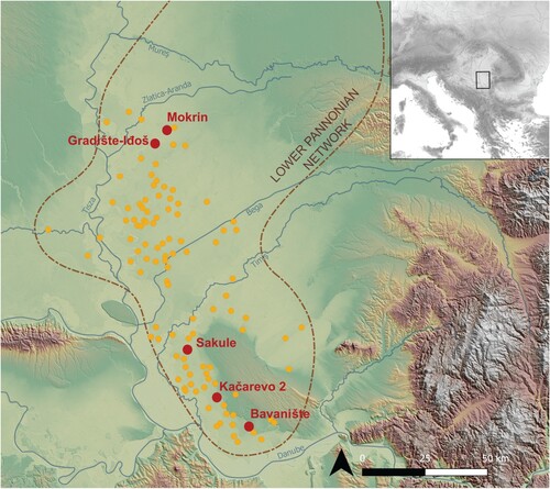
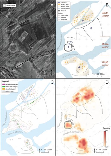
Within the lower Pannonian network, we focus on the Tisza Site Group (TSG): the densest network of known sites. Defined through satellite imagery and pedestrian survey, over 100 sites ranging in size from 5–200 ha have been identified within an area of ca. 8000 km2 () (Molloy et al. Citation2023b). With few settlements being located more than 5 km from their nearest neighbors, we know that each site was intimately linked within this network. Though defining a political geography is premature at this stage, population size coupled with nodal properties of proximity, asymmetric size, and spatial complexity (unenclosed and uni- or multivallate) suggest the TSG and lower Pannonian network had a “complexity based around a network of multifunctional or polyfocal centres” (Molloy et al. Citation2023b, 37). We are less clear on what was happening within settlements.
Figure 1. Map of the Tisza Site Group (yellow) and lower Pannonian network with the sites surveyed (red) (map layer credit: Produced using Copernicus data and information funded by the European Union—EU-DEM raster).
Our first goal is to explore aspects of internal social organization using site-specific spatial data from a sample of TSG sites. To achieve this, we combine aerial/satellite imagery, geophysical survey, and intensive systematic surface survey to explore the internal organization of five TSG settlements of diverse size and spatial complexity. While each site had a unique developmental trajectory and social significance to its inhabitants within the landscape, comparative analysis allowed us to identify aspects of settlement organization that were part of and contributed to a collective ethos in TSG communities. Collective ethos is understood as “a series of social norms, shared beliefs, and … seeing the world as an extension of each individual” based on “shared myths, communal memories, ideologies, etc., that are communicated through specific material and nonmaterial media” (Driessen and Letesson Citation2023, 6; see also Geertz Citation1973, 426–401; Wood and Powell Citation1993, 405). The second goal is to empirically confirm hypotheses about physical features visible in satellite imagery in order to extend certain social inferences to other TSG sites (Molloy et al. Citation2020, 295–298; e.g. Molloy et al. Citation2023b, 20–21).
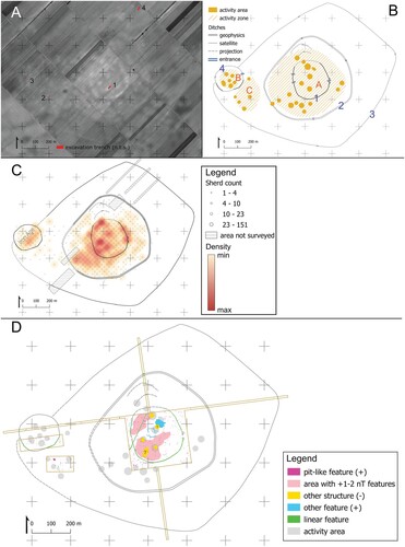
Our recent paper (Molloy et al. Citation2023b) has reviewed the current evidence characterizing the common feature of TSG sites and their societal context in diachronic perspective. TSG sites share remarkable similarities in choice of landscape (low-ground), engagement with the landscape (ditches or networks of ditches are visible in aerial images of many settlements), and material culture. Prospection survey demonstrated that the sites are all Late Bronze Age and broadly contemporary based on relative chronology of surface pottery attributable to the Belegiš I, Belegiš II, and Dubovac-Žuto Brdo ceramic groups (Molloy et al. Citation2023b, fig. 5, S4). AMS 14C dates from nine TSG sites show the earliest occupation may have been the 17th century b.c. These dates suggest that most were founded by the mid-16th–15th centuries b.c. (), corresponding closely with the relative chronological range established with 14C dates from closed contexts at cemeteries and settlements in the TSG and surrounding area (e.g. Corneşti-Iarcuri in Lehmphul and colleagues [Citation2019]; Pecica-Site 14 and Tápé in Sava [Citation2020]; Sântana-Cetatea Veche in Sava, Gogâltan, and Krause [Citation2019]). Satellite imagery reveals specific surface features that are diagnostic for the TSG network sites (). Presence/extent/absence of features is based on surface visibility in satellite imagery and aerial photography alone—meaning some features may remain undetected—and those we commonly identify are defined as: activity areas—sub-circular pale spots in the soil of 20–30 m diameter that have, in contrast to surrounding topsoil, concentrations of pottery and domestic debris visible at the surface; activity zone—spaces where activity areas cluster together; enclosure(s)—one or multiple enclosure ditches, partly or completely surrounding the activity zone (this applies to approximately 50% of sites, and size tends to be correlated with spatial complexity [number of enclosures]); and, buffer zone—area between activity zone and largest enclosure with no visible activity areas.
Figure 2. Modelled 14C dates from TSG sites, including those discussed in this paper and the cemetery, Budžak-Livade, next to Gradište Iđoš (in Molloy et al. Citation2023b, fig. 13).
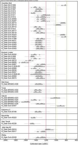
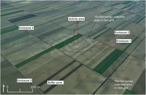
Figure 3. Aerial image of Sakule with imprint of grid left from surveyors’ footsteps mid-survey (blue lines) and main physical features characteristic of the Tisza Site Group (red lines). (Photo by Barry Molloy and Darja Grosman).
Methods
Site and method selection
The sites for study were selected to explore the various site formations of the TSG according to geography (sampling along a north-south distribution), size, and spatial complexity (number of visible ditches). The sites of Bavanište, Kačarevo 2, Sakule, Mokrin, and Gradište Iđoš were selected, and key information about each is listed in . Some sites were selected because they are at maximal ends of the size and spatial complexity spectrums: Gradište Iđoš is the largest site in the TSG, and Mokrin has the highest number of visible ditches. Others were selected to represent more common site formations: Bavanište is a small site with a partially visible enclosure, Kačarevo 2 is a medium site with a complete enclosure—selected specifically because it is located on and at the base of the slope of the Deliblato loess plateau (see ) (see Molloy et al. Citation2023b, fig. S1/19)—and Sakule is one of the largest sites with at least three concentric and one non-concentric enclosures. Moreover, some sites were known from the literature: Kačarevo 2 and Mokrin were identified and partially surveyed as part of extensive (non-systematic) surveys of Pančevo and Kikinda territories (Ćuković Citation2013; Трифуновић Citation2020, 81, 83). Gradište Iđoš was first excavated in the 1950s, known due to its standing rampart (Grbić Citation1950, Citation1951), but the full extent was only recently identified and ground-truthed (Molloy et al. Citation2020, Citation2023b). Bavanište has not been previously published or documented. Past and planned excavation campaigns at Gradište Iđoš and Sakule made these sites desirable to survey, given we had the opportunity for confirmation of occupation phases through AMS 14C dates. Magnetometry was conducted as part of a wider campaign for The Fall of 1200 b.c. project that included Mokrin, Sakule, and Gradište Iđoš to support evaluations for possible future excavations. Though all selected sites are enclosed, it must be noted that survey campaigns took place between November 2019 and April 2022, during which time we more than doubled the list of TSG sites—many of them with no visible enclosure—through satellite prospection, with confirmation by field prospection (Molloy et al. Citation2023b; see also Estanqueiro et al. Citation2023).
Table 1. Key information about surveyed sites. Note: Number of enclosures are those visible in satellite imagery (Vis. encl.).
The large size of TSG sites makes them a challenge to investigate fully with any method—those surveyed here range from 20–200 ha. Most of the land in Vojvodina today is agrarian, and deep ploughing (60–70 cm) in the 20th century a.d. substantially damaged archaeological features. Hence, due to the size and number of sites, as well as their likely poor state of preservation, excavation to any large degree of coverage at the site and network level is unrealistic. On the other hand, surface survey in ploughed soil can map the distribution and, to a limited degree, the nature of some activity on-site—for example, the colocation of coarsewear, animal bone, quern stones, and building material could indicate a food consumption space with structural elements. However, in this first publication of its kind for the TSG, we limit our analysis to presence/absence of activity in general terms based on pottery sherds.
Despite the lack of stone in the Carpathian Basin, magnetometry is well-suited to revealing ditches in this soil geology and has revealed the presence of a handful of structures at some lower Pannonian network sites, e.g. Sântana-Cetatea Veche, Corneşti-Iarcuri (Gogâltan, Sava, and Krause Citation2019; Lehmphul et al. Citation2019; Szentmiklosi et al. Citation2011). The TSG site of Gradište Iđoš had previously been partially surveyed with magnetometry (Marić et al. Citation2016; Molloy et al. Citation2020). This suggested from the outset that the invisibility of Bronze Age structures in magnetometry data at TSG sites may be because negative features were backfilled with the same material and because they were not burnt, which means they lack oxidized soil that can create a strong magnetic signature, as seen for example in the Neolithic sector at Gradište Iđoš. Hence, surface survey and geophysical survey are both well-suited to measuring site-wide patterns of spatial organization and will support future, targeted excavations.
Remote sensing
Satellite images were used to define the spatial extent of enclosures and the location of activity areas and zones within sites in advance of fieldwork. This provided spatial parameters for investigation at each site. Google Earth Pro (desktop version) was used for sourcing satellite imagery, as it provides high spatial resolution (2.5 m). We georeferenced downloaded maximum resolution images from Google Earth (GE) Pro (8192 × 4968) in QGIS. Key features such as ditches, activity areas, and paleochannels were drawn manually based on georeferenced GE images in QGIS for the comparison to magnetometry and surface survey.
Geophysical survey: magnetometry
Geophysical survey was conducted at three of the five sites as part of The Fall of 1200 b.c. project (see Funding and Acknowledgements), and results are presented here for those sites. The purpose was to 1) test the presence of ditches visible in aerial images, 2) define further linear anomalies, 3) explore the internal features of activity areas, and 4) define other subsurface features and how they relate to ditches and activity areas that were not visible in satellite images. Large rectangular areas were surveyed in the activity zones, and thin transects were used to test ditch locations. A Sensys GMBH gradiomenter on fluxgate sensors, model Magneto MXPDA with a 5-probe system of FGM650/10, range of + -10 uT was used. Probes have twin sensors with 65 cm vertical distance between them. The rover of a GNSS Stonex S10A unit was used to deliver sub-centimeter spatial precision.
Systematic surface survey
The objectives of the surface survey were to 1) use artifact density to map surface distribution and infer intensity of subsurface activity and 2) collect diagnostic material to map chronological patterns. For pottery, we used a combination of 100% collection and partial collection to reduce post-field labor and storage pressure in museum depots. The latter strategy entailed collection of all diagnostics plus in-field counting with clickers of body sherds and was only used when LBA chronology could be established for sherds based on fabric and absence of diagnostics from other periods (see Rassmann et al. Citation2018). Partial collection was used at all sites to varying degrees but most often for counting and not collecting small sherds (< 2 cm). Daub was only collected if diagnostic (e.g. multiple wattle impressions were considered diagnostic) and only worked bone was collected, given that we cannot ascertain the chronology of either in surface assemblages. All other small finds such as bronze or stone tools were collected.
The prospection surface survey (Molloy et al. Citation2023b) had indicated that artifact density spiked in activity areas. To test this systematically, two survey methods were applied and developed iteratively during the project. We started with a grid method, typically used on settlements, at the smaller sites of Kačarevo 2 and Bavanište. Given our goal of defining site-wide patterns, the size of the larger sites made this method impractical and incomplete, especially if we wanted better than 50 m resolution. Facing a similar dilemma, Rassmann and colleagues (Citation2018) developed a point transect method and achieved their goals with both methods at early 2nd millennium b.c. Fidvár (Slovakia). We adapted their parameters for the larger size of our sites.
A 50 × 50 m grid was overlayed on satellite images for Kačarevo 2 and Bavanište and defined on the ground using GPS, and we conducted a targeted sampling of squares (non-random). Squares to sample were chosen based on the location of the visible activity zone and activity areas. More squares were surveyed in the activity zone and fewer outside of this in the buffer zone. Two squares were also surveyed outside the enclosure to verify the previously observed lack of extra-site activity. The grid was laid out in the field with a Trimble 7x GNSS with satellite connection, which provided 1–2 cm accuracy. Each square was split into five lanes of 10 m with flags and a 50 m tape. In each 10 m transect, surveyors did two passes, so they had to observe 2.5 m on each side. With two surveyors per square, 10 minutes was allotted to each square. Given the squares are larger than activity areas (20–30 m diameter) and the latter may only be partially within the square, detailed notes were taken of observed variances in pottery concentrations within squares. Two types of heatmaps were produced with this information: 1) a grid approach where the sherd count is the value assigned to each 50 × 50 m square, resulting in a pixelated map, and 2) the point method where each sherd is one point in the map. To create the latter, points were randomly assigned a location within a grid square (according to the count recorded for that cell) using the QGIS Random Point research tool. Then, according to field notes, an approximated fraction of the points was manually moved to the area where pottery concentrations were observed in the field. While this is subjective, it complements the pixel map to show more specific concentrations.
The second method was the point transect method (Rassmann et al. Citation2018). This involved walking in transects 25 or 50 m apart and stopping every 25 or 50 m to collect all the pottery in a 10 × 10 m area (the point). is an aerial photograph of Sakule with imprints of the grid from surveyor footprints visible and serves as an illustration of the point transect grid. Using previous knowledge from prospection survey, the resolution was tailored so that in activity zones observed in satellite imagery, the transects were 25 m apart, and in areas with no activity areas visible, 50 m transects were used. The grid was made in QGIS and navigated in the field using a handheld Trimble Geo7x without satellite uplink, which achieves 2–4 m accuracy. We surveyed at each point for 1.5–3 minutes, depending on the experience of volunteers (longer times at the beginning of the season) and visibility/coverage. Heatmaps were created using the Heatmap Symbology tool in QGIS with a 25 m grid for the entire site given the function measures density with points weighted by value (non-surveyed points had a value of 0).
Because of their size, the sites were spread across multiple agricultural fields that had different owners and different harvest and ploughing timelines. We surveyed in the months of October/November and March/April when ploughing was commonly under way or completed. As a result, visibility varied from field to field, and the impact of this on survey coverage can be seen in , where, at Sakule, agricultural land is split into many small holdings. Vegetation ranged from sparse new growth to grass to cut maize stems. In most cases, sherds were still visible. Evaluations were made in the field, and if visibility of < 10% was determined, that particular field was not surveyed.
Excavation
1 × 1 m test trenches were dug on activity areas in three of five sites to obtain an idea of vertical stratigraphy but mainly to obtain material for 14C dating. All trenches were excavated to subsoil. Generally, the stratigraphy consisted of 40–60 cm of plough-zone consisting of cultural material likely to have been building material (pale in color) intermixed with topsoil. This disturbed layer contained most of the cultural material, mixed and therefore poorly stratified. Beneath this lay a cultural layer of 20–40 cm that contained less abundant material, which in turn lay above the natural loess subsoil. With small prospection windows, this stratigraphy is considered a generalized picture. The locations of excavation trenches are in the respective figures in the results section, and 14C dates are in . Two trenches were excavated at Kačarevo 2, though only one yielded material culture finds; one trench was excavated at Bavanište; and, three were excavated at Sakule, but only two yielded material (trenches 2b and 3b in ). Moreover, in 2020, as part of The Fall of 1200 b.c. project, at Sakule, a 3 × 10 m trench was excavated on an activity area and yielded two superimposed, but ephemeral, building features (trench 1a in ), and another 4 × 12 m trench was excavated in 2021 through the outer ditch (trench 2a in ) (publication of the excavation is in preparation). The most recent excavation campaigns at Gradište Iđoš (from 2014) have mainly uncovered pits and ditches (Marić et al. Citation2016; Molloy et al. Citation2017, Citation2020). Most dates come from the citadel area, but in 2021, two trenches were excavated through ditches in the two northern enclosures 5 and 6, and absolute dates were obtained from material sampled from their fills (trenches 20 and 21 in ).
Table 2. 14C dates from surveyed settlements. See feature/location column for figure numbers in this study with location of trenches. Full data can be found in Molloy and colleagues (Citation2023b, table S1).
Relative and absolute dating of internal TSG settlement activity: an overview
We predominantly rely on the established pottery typo-chronology to date settlement activity mapped with survey and geophysics, but we also support this verification of habitation during those ceramic horizons at four of five sites with 14C dates from test or systematic excavation on activity areas and ditches (the exception being Mokrin) (see ). Pottery from preceding and succeeding phases can be differentiated, and so the 14C accords with the general timeline for the occupation history of these sites, pending further excavation and absolute dating. In the following discussion, we will address 1) the dependability of surface assemblages for dating and 2) the reliability of date ranges for social inference.
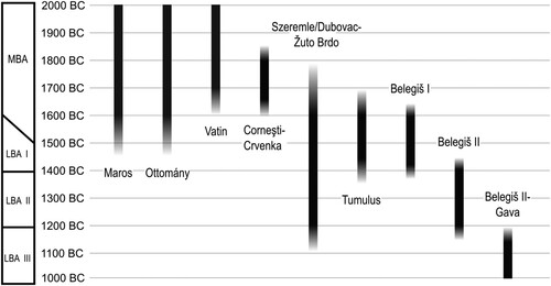
The pottery typo-chronology of the LBA south Pannonian Plain is well-established, and recent reviews provide sharper resolution on the dating (Forenbaher Citation1994; Gogâltan and Stavilă Citation2020; Ložnjak Dizdar Citation2023; Metzner-Nebelsick et al. Citation2023; Molloy et al. Citation2023a; Citation2023b, 5–7; Sava Citation2020; Sava and Ursuțiu Citation2021; Szabó and Váczi Citation2023; Szentmiklosi Citation2006; Szeverényi et al. Citation2022; Tasić Citation2004; Todorović Citation1977). Sherds in the plough soil were commonly small and worn and dominated by undecorated body sherds, with more occasional diagnostic sherds suitable for closer dating. Body sherds from finer handmade ware can often be dated to broad periods based on form, fabric, surface treatment, and firing temperature, but there is a certain margin of error for differentiation between body sherds from the Late Bronze, Early Iron (Kalakača, 1050–800 b.c.) and high Medieval Ages (11th–13th centuries a.d.). Typically, forms such as bowl, urn, and cup sherds were more often diagnostic to phases and sub-phases. Coarseware fabrics and shapes such as storage jugs or the sadjak (pyraunoi) cooking vessel were consistently used throughout the Bronze and Early Iron Ages (EIA) and limit chronological discrimination (Fischl, Kiss, and Kulcsár Citation2001; Romsauer Citation2003). The main LBA pottery styles found in the south Carpathian Basin are: Belegiš I, Dubovac-Žuto Brdo (DŽB), Tumulus, Belegiš II, Proto Gava, and Belegiš II-Gava. These were all handmade. Their absolute chronology according to the current state of research, using 14C dated contexts where possible, is illustrated in . As concluded by Sava’s (Citation2020) study, there is much continuity in decoration style throughout the LBA, and this is particularly true from the Belegiš II to Belegiš II-Gava phases (1425–1000 b.c.) (see also Duffy et al. Citation2019). However, the frequency (in closed contexts) and combinations of decorative motifs and forms can sometimes be more chronologically restricted, e.g. as we suggested in our dating of Jaša Tomić in the TSG area to the Belegiš II-Gava phase based on surface finds (Molloy et al. Citation2023b, 30). Early Iron Age occupation is often attested at LBA sites by Kalakača pottery (1050–800 b.c.), which shows important continuity with LBA styles but can typically be differentiated by 1) variations in decoration motifs, 2) lack of precision and symmetry of incised decoration, and 3) often lower firing temperatures.
Figure 4. Chronology of main pottery styles of the MBA and LBA in the south Pannonian Plain (after Molloy et al. Citation2023b, fig. 2). Note: we include the Otomani-Füzesabony Cultural Complex (OFCC) in the presented range.
The MBA-LBA pottery typo-chronology based on 14C dates has phases of 200–250 years (see ), and the AMS dates for features generally have ranges of 100–150 years. These are common probabilistic ranges for most archaeology in European prehistory (e.g. Capuzzo, Boaretto, and Barceló Citation2014; de Mulder and van Strydonck Citation2008; Gogâltan Citation2019; Kiss et al. Citation2019; Roberts, Uckelmann, and Brandherm Citation2013). For the purposes of social inference, we must make certain assumptions about contemporaneity of features based on our gathered data.
There is some indirect evidence that suggests contemporaneity of features. We noted in Molloy and colleagues (Citation2023b, 26) the possibility of horizontal movement of communities in the TSG but argued that this was less likely to explain the relative uniformity of distribution in the social landscape than if most sites were contemporary. A similar argument can be made for internal features such as activity areas and ditches such that through spatial layout (the organization of features) we can infer contemporaneity or at least memory of placement. This is seen, for example, in the relatively equidistant spacing of activity areas and the regularity in the distance between the limit of the activity zone and the surrounding ditches. Extrapolating from the test excavation at Sakule and the depth of deposits in the 1 × 1 m test trenches, it is probable that some built loci had multiple vertical phases of occupation. Clarification of the nature of activity requires further excavation, though present evidence suggests lengthy occupation at specific loci as a working model rather than horizontal movement with shorter occupation of individual structures/loci. This suggests a conceptual similarity to the intergenerational dwelling and resultant construction of tells during the MBA, even if activity loci are regularly dispersed within TSG sites.
While more 14C data from systematic excavation will refine this model, they will not resolve key outstanding issues mapping the temporality of occupation at TSG sites. A common issue with ditches and pits (two of three main features on TSG sites) is that material from fills relates to the abandonment of features, not their original excavation and use. Moreover, a key challenge is the dispersed/standalone distribution of pits, ditches, and activity areas that removes the possibility to define relative dating by stratigraphic relationships through excavation. The duration of activity would need to be dated independently for each feature. Problematically, due to extensive deep ploughing, the later phases of occupation of activity areas are destroyed, and therefore only a partial duration of activity can be observed based on material from lower secure strata (foundation) and upper, more disturbed, strata, as was the case at Sakule. Consequently, we infer temporal relationships from surface material as a model suited to further testing through excavation and dating campaigns.
Results
Kačarevo 2
Kačarevo 2 is located 1 km southeast of the modern town of Kačarevo. The survey was conducted in November 2019. Based on aerial imagery, a single sub-circular ditch encloses an area of 40 ha, and the activity zone is in the center of the enclosure (A–B). Only two-thirds of Kačarevo 2 were surveyed because the southern third remained unploughed and was under dry maize, resulting in < 5% surface visibility. A total of 44 50 × 50 m squares were surveyed. About one quarter of the site in the northeastern part is on the slope of the loess plateau with an 8–10 m differential elevation.
Figure 5. Kačarevo 2 results: A) satellite image (source: Google and Maxar Technologies (gray-scale)) with location of 1 × 1 m trench with 14C dated material, B) vector illustration of LBA features on a topographic model, C) pixel heatmap, and D) point-based heatmap.
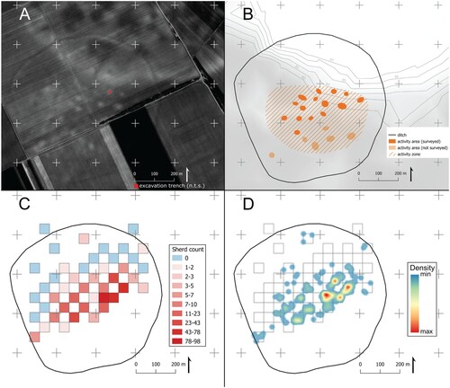
C–D shows the pixilated and point-based heatmaps. They both demonstrate that pottery is confined to the activity zone, with ca. 1–2 stray non-diagnostic sherds found in buffer zone squares. If we extrapolate to the other half of the site, 30% (12 ha) of the site was occupied with visible traces, which means the buffer zone makes up 70% (28 ha) of the enclosed area. The topographic model in B demonstrates that the activity zone was confined to the base of the slope even though part of the incline was enclosed. The sand-rich soil of the slope does make it easier for material to be dragged to the base by ploughing. However, visible activity areas in satellite imagery are on the low ground, and this pattern is repeated at other TSG sites that abut the sand-capped loess plateau to the north and south, e.g. Bavanište (below), Pančevo, Dolovo, etc. (see ). The heatmaps also demonstrate the center-east part of the activity zone has the highest sherd count. This may be caused by a few different processes such as the longest occupation, the most intense consumption of pottery, and/or more damage to LBA features through ploughing. The activities areas that have the highest sherd counts also have the “brightest” and most defined pale spots in aerial imagery. We believe the pale color of the soil is due to a higher concentration of loess subsoil close to the surface because it had been used in building material recipes to make structures in those locations (Molloy et al. Citation2023b, 20).
Pottery recovered was of the DŽB, Belegiš I, and Belegiš II styles, along with voluminous Sarmatian pottery in the western part of the site (, ). This indicates an LBA occupation between the 16th and 12th centuries b.c. (see ). Two 1 × 1 m test trenches were excavated on different activity areas; one was poor in material, while the other was rich. 14C dating from Trench 2 associated with Belegiš II and DŽB pottery produced a 14th century b.c. date (see A, ).
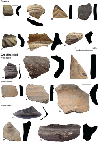
Figure 6. Surface pottery from Kačarevo 2, Bavanište, and Sakule.
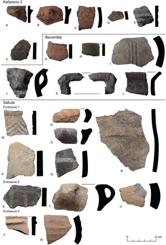
Table 3. Pottery typo-chronology from surveyed sites based on surface collection diagnostics according to site area (if different).
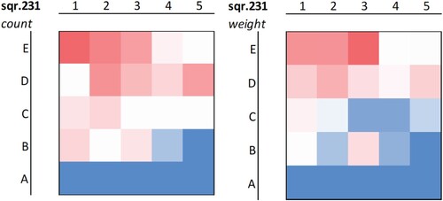
Our preliminary observation that most pottery on the settlements is concentrated on activity areas and, to a lesser extent, across activity zones was confirmed with this survey data. While this was evident when conducting fieldwork, i.e. when we could see the pale soil of activity areas on the ground, there was always more pottery, we performed a test on square 231 to demonstrate this using a 10 × 10 m grid. is a heatmap showing the elevated sherd count in the upper half and, more specifically, in the northeastern quadrant where the activity area was located.
Figure 7. Heatmap of square 231 at Kačarevo 2 with a 10 × 10 m grid demonstrating the higher concentration of pottery on the activity area in the northeast by count (left) and weight (right). Red is high and blue is low count.
Bavanište
The site of Bavanište lies ca. 1 km north of modern Bavanište and 19 km east of the Danube-Tamiš confluence, near the southern limit of the TSG. The survey was conducted in November 2019. Aerial imagery reveals a sub-rectangular ditch on the western side, while the eastern side faces the sharp incline of the loess plateau (13 m differential elevation) ca. 250 m east by northeast from the activity zone. A shows a satellite image of the site that is 22 ha in extent, based on visible features.
Figure 8. Bavanište results: A) satellite image (source: Google and CNES/Airbus (gray-scale)) with location of 1 × 1 m trench with 14C dated material, B) vector illustration of LBA features on a topographic model, C) pixel heatmap, and D) point-based heatmap.
C–D shows Bavanište pottery count heatmaps. Pottery was concentrated in the activity zone, and none was found in the buffer area or outside the enclosure. Like at Kačarevo 2, pottery concentration was highest on activity areas and drops significantly, to zero in some cases, between activity areas. Notably, the brightest activity area is the one with the highest sherd count. The southeastern part of the site had < 5% visibility during the survey and was therefore not surveyed, but given that no activity areas are visible in satellite imagery, it is assumed to be part of the buffer zone. Thus, the activity zone is approximately 12 ha, or 50% of the site. Pottery analysis demonstrated that DŽB, Belegiš I, and Belegiš II pottery styles were produced/consumed at the site (see , ). 14C dating from the 1 × 1 m test trench on an activity area produced a 15th century b.c. date associated with DŽB diagnostic material (see , A).
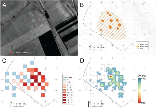
Sakule
Sakule is located 3.2 km west of modern Kovačica and 10–15 km east of the Timiş River, just north of its confluence with the Danube. The survey was conducted over two field seasons in March 2020 and November 2021. Three concentric enclosures (#1–3) and one small circular enclosure (#4) interrupting the largest ditch on its western edge are visible in remote prospection (A). The outer ditch encloses an area of 90 ha. Based on the satellite imagery, there are 3 activity zones: 1) within the two central Enclosures 1 and 2, 2) Enclosure 4, and 3) between Enclosures 2 and 4 (see A–B). The central enclosure, in satellite imagery, is a white ring, which indicates disturbed soil, potentially the imprint of a rampart that no longer stands today. The buffer zone lies between Enclosures 2 and 3 (excluding Activity Zone C).
Figure 9. Sakule results: A) satellite image (source: Google and Maxar Technologies) with location of trenches with 14C dated material (squares = 1 × 1 m trenches), B) vector illustration of LBA features, C) heatmap of pottery count, and D) geophysics interpretation (gray activity areas from satellite imagery, beige lines show extent of geophysics data).
Geophysical survey
Geophysical survey was conducted in three rectangular blocks covering the three activity zones identified in satellite imagery and four radial transects from the central ring to the outside of the settlement (). The magnetometry survey confirmed all enclosures visible in satellite imagery were single ditches, except for Enclosure 2, which is a double ditch with approximately 7 m in between. Two further potential concentric ditches were identified in the northern quadrant of Enclosure 2 that are not visible in the other radial transects or satellite imagery.
Figure 10. Geophysical survey results of Sakule.
The largest magnetometry survey area covers most of Enclosure 1 and a small portion of Enclosure 2 (see A). Three entrances are visible in Enclosure 1: two on the east and one on the west. The eastern entrance has additional structures at the terminals, one square on the north terminal and one half-circle at the southern terminal. Situated within the causeway of the western entrance, there is a rectangular structure, possibly of Medieval date. Two of the entrance termini have strong positive anomalies.
Within Enclosure 1, the western half of the enclosure has more activity than the east. Most of the activity consists of 3–5 m sub-circular positive anomalies (+3–6 nT), likely pits that are ubiquitous on LBA sites. Two patches in the western half of the enclosure have frequent sub-circular features with weak positive readings of 1–2 nT. Three large circular anomalies, and a possible fourth, spatially correspond to activity areas (see D, A). These are slightly negatively charged (-0.5–2 nT) circles surrounded by slightly positively charged bands with diameters of 20 m, 25 m, and 21 m, respectively. This is in line with the sub-circular shape of most activity areas on TSG sites but contrasts with other lower Pannonian network sites where house structures—admittedly rarely identifiable—appear to have been rectangular (e.g. at Corneşti and Sântana [Gogâltan, Sava, and Krause Citation2019, fig. 7; Lehmphul et al. Citation2019, fig. 13]). It is worth noting that geophysics at the multiperiod TSG site of Borđoš, when overlapped with a satellite image, shows a linear feature (ditch?) in the LBA part of the site surrounding an activity area, though it has not been excavated (Hofmann et al. Citation2020, fig. 2). Resolving the nature of the circular structures requires excavation, but it is salient to note that surface ploughing only caused the size of the structures to be slightly exaggerated from e.g. 20 m to 25 m diameter in one case. There is a potential large rectangular feature (32 × 42 m) in the center of Enclosure 1, though the sides are only weakly positive, and this would require excavation to confirm. A further rectangular feature lies next to the northwestern entrance to Enclosure 1, but due to disjointed placement relative to the ditch, it may be earlier or later. Comparatively, the areas surveyed in Enclosures 3 and 4 have proportionately fewer visible anomalies and no visible structures (see B).
Systematic surface survey
The heatmap in C correlates with patterns in satellite imagery. The densest activity is in Enclosure 1, while Enclosure 3, with the exception of Activity Zone C, can be confirmed as a buffer zone from which little to no pottery was recovered. In Enclosure 1, pottery concentration is highest in activity areas. Notably, two of the entrances appear to have high pottery concentrations. Activity Zone C in Enclosure 3 had low density of pottery visible at the surface. Pottery distribution indicates that Belegiš I–II and DŽB are concentrated in Enclosures 1 and 2, while Belegiš II-Gava and/or Kalakača pottery can be found throughout the site (see , ). The diagnostic pottery from Enclosure 4 is exclusively Kalakača. The latter pottery does not conform to the LBA pattern of higher concentration in activity areas, indicating a different use of space in the EIA. The results are in line with 14C dates from trenches through the outer ditch of Enclosure 3 and the 1 × 1 m test trench in an activity area of Enclosure 4 (trenches 4 and 3 in A), which are Early Iron Age (see ). Dates from Enclosures 1 and 3 in the Activity Zones A and C are between the late 18th and late 13th centuries b.c. (trenches 1 and 2 in A, ).
Mokrin
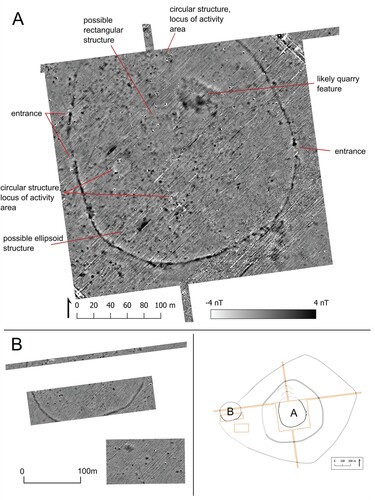
Mokrin lies ca. 3 km southeast of modern Mokrin. The survey was conducted in November 2021. Mokrin is unique in the TSG because, despite its modest size of 58 ha, it has six concentric ditches visible in satellite imagery and a wide but dense spatial distribution of activity areas. The density and distribution of activity seen in the remote imagery are also visible in the geophysical data. It is unclear if the water channel running east-west (A), remaining as a deep dry channel today, was active in the LBA, but based on the ditch activity, it is unlikely. Some other small channels on the site may have been active.
Figure 11. Mokrin results: A) satellite image (source: Google and Maxar Technologies), B) vector illustration combining data from satellite and geophysics and key for numbered enclosures for text, C) geophysics interpretation (gray activity areas from satellite imagery, beige lines show extent of geophysics data), and D) heatmap of pottery count from surface survey.
Geophysical survey
The magnetometry confirmed the location of ditches visible in satellite imagery and revealed five additional enclosures within Enclosure 1 (, B:1.1–5). If we include the projected ditches, there are approximately 11 km of ditches at Mokrin (B). Some ditches are cut by others, though, indicating they were not necessarily all contemporary. Enclosures 1.1 and 1.3 are quite small (projected 0.8 and 0.6 ha, respectively) and enclose two activity areas each. There are four entrances that are linearly aligned, creating a causeway that runs east-west down the midline of Enclosure 1 (see ). In the east of the activity zone, there is an entrance from Enclosure 2 to Enclosure 1 also cutting through multiple ditches. This eastern entrance passes through a possible rampart and palisade on the interior of Enclosure 1.4 (see ).
Figure 12. Magnetometry of Mokrin in the central enclosure.
The activity zone in Enclosure 1 shows different spatial distribution patterns of positive pit-like anomalies (2–5 m diameter). Within Enclosures 1.1, 1.3, 1.4, and 1.5, pit-like anomalies are randomly distributed, like at Sakule. Though this is speculative, organization appears different in Enclosure 1.2: pit-like anomalies are potentially organized in parallel linear transects with empty space in between in a grid-like organization of space (see ). The radial transects give some indication that the areas outside the activity zone visible in satellite imagery have limited to no activity. For example, this is the case for Enclosure 5 (1.6 ha) within the 0.2 ha surveyed area (C).
There are two activity areas with sub-circular anomalies, though they differ from those at Sakule. In Enclosure 1.5, there is a circular negatively charged feature (-2nT, 7 m diameter) with a diffuse positively charged band around it (+1-2 nT, 2.5 m thick) (see ). In Enclosure 1.2, a similar structure is visible but with the opposite charge: positive (+1-2 nT) in the center and negative (-2 nT) in the diffuse ring. The numerous activity areas at Mokrin suggest intense and dense occupation, but these are the only traces of potential architectural features on activity areas. Other activity areas tend to have no visible sub-surface traces apart from one or two strongly positive pit-like features of approximately 3 m diameter.
Systematic surface survey
The heatmap (D) from the surface survey displays extensive activity in Enclosures 1 and 2 and, to a lesser extent, in 3. As with other sites, pottery concentration is highest in activity areas and found consistently throughout the activity zone. Two areas in Enclosure 1 have visibly low surface density, and these correlate with a lack of activity areas and a higher density of pit-like anomalies (see C–D). This may indicate the pits in these areas were not used for refuse or that the pottery was buried deep and there was limited or no activities on the Bronze Age ground surface in these areas. Two activity areas (or clusters of 2 activity areas) in the northwest of the activity zone have very high densities of pottery, and this is where a piece of bronze from an unidentifiable object type was found. There is a buffer zone between Enclosures 3 and 4 with little to no activity documented through our surveys. Enclosures 5 and 6 in the east had no surface finds, and though surface visibility was suboptimal in this eastern part of the site due to both coarse ploughing and residual crops, the low observed pottery count is supported by the dearth of anomalies in magnetometry. Belegiš II was the main pottery type found on site, together with a few diagnostic Kalakača sherds that indicated sparse Early Iron Age occupation (). Fragments of burnt daub with wattle impressions were recovered, along with cooking vessel (sadjak) fragments that are undiagnostic in terms of chronology but indicate domestic activity. A Neolithic polished stone axe was also recovered.
Figure 13. Pottery from surface survey at Mokrin and Gradište Iđoš.
Gradište Iđoš
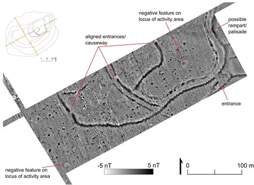
The site of Gradište Iđoš is located 5 km northwest of modern Kikinda. The survey was conducted over two seasons due to rotating crops: October–November 2021 and April 2022. It is unique in the TSG because of its size (200 ha) and morphology. The earliest features thus far excavated date to the mid-15th century cal b.c., and a hiatus occurs from around 1200 cal b.c. until ca. 1050 cal b.c., with final abandonment in the 9th/8th century b.c. (see , ). Absolute dates show the adjacent cemetery of Budžak-Livade was established by the late 17th century b.c. and abandoned before the turn of the 12th century b.c. (see ). We use three arbitrary divisions of the North Sector, the Middle sector, and the South sector to facilitate discussion (B). The site is divided by the drained courses of the Berčulja and Grčka River channels, which were transformed into the DTD Canal in the 20th century a.d.
Figure 14. Gradište Iđoš results: A) satellite image (source: Google and Maxar Technologies (gray-scale)), B) vector illustration combining data from satellite and geophysics and key for numbered enclosures for text, C) geophysics interpretation (gray activity areas from satellite imagery, beige lines show extent of geophysics data), and D) heatmap of pottery count from surface survey.
Satellite imagery shows a complex network of ditches and two spatially distinct activity zones (A). In the North Sector, there is a partially visible enclosure around an activity zone with an area of at least 46 ha (Enclosure 2). Directly south, two north-south oriented ditches enclose another 19 ha, which has no visible activity areas (Enclosure 3). In the middle sector, the standing rampart encloses an area of approximately 2 ha, with no visible activity areas. The rampart and surrounding ditches have been the focus of most excavation (Molloy et al. Citation2017, Citation2020). The partially visible enclosure with two concentric ditches in the south sector encloses approximately 13 ha (Enclosure 4) and includes the second activity zone.
Geophysical survey
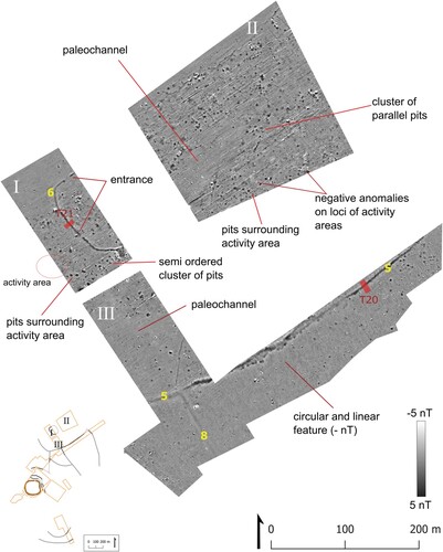
A 2014 magnetometry survey by Patick Mertl has been published previously and was focused on the upstanding rampart area (Molloy et al. Citation2020) (A). The 2020 magnetometry campaign at Gradište Iđoš covered the North, Middle, and South Sectors (see B–C, 16). Anomalies are concentrated in the activity zones of Enclosures 2, 4, and 1 (within the rampart) and the unenclosed area immediately east of the rampart and consist mainly of pit-like features. Outside these areas, there is little to no subsurface activity, with the exception of a few pit clusters immediately outside Enclosure 1 (see A). The area displayed in B included one of four bright pale spots east of the rampart but revealed few anomalies, indicating these may be natural. Paleochannels created empty spaces in the geophysics tiles, e.g. Areas I and III in , though it remains unclear if they were active during LBA occupation.
Figure 15. Magnetometry of Gradište Iđoš in the middle and south sectors. Yellow numbers indicate the ditch number IDs, and red squares mark the location of excavation trenches of ditches with 14C dated material (not to scale).
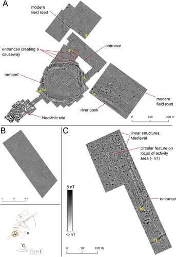
Figure 16. Magnetometry of Gradište Iđoš in the northern sector. Roman numerals name the tiles of surveyed areas for the text, yellow number the ditch number IDs, and red squares mark the location of excavation trenches with 14C dated material (not to scale).
The results confirmed the ditch features visible in satellite imagery and exposed several more. Within Enclosure 2, an additional concentric ditch is visible which has entrances on its western and northern sides (ditch 6, Area I, see ). This enclosure has a projected area of 1.1 ha and contains two activity areas. 14C confirms that it was likely contemporary with the larger ditch 5 of Enclosure 2 (terminus ante quem of 14th–13th centuries b.c., trenches 20 and 21 in ). Around Enclosure 1 (rampart), three additional concentric ditches are visible north of the rampart (see A, ditches 2–4). Ditches 2 and 3, closest to the rampart, have entrances that create a causeway leading to the rampart entrance.
Subsurface features in activity areas have various morphologies. In Enclosure 4, one negatively charged circular feature, like those seen at Sakule, is attested on the locus of an activity area (C). This is the only such feature visible in the geophysical dataset from Gradište Iđoš. Additionally, there are numerous sub-rectangular foundation ditches that do not align with any known activity areas, and therefore it is probable that the linear features are Medieval, considering the substantial Medieval activity found during surface surveys in this same area. Within Enclosure 2, some activity areas have negatively charged sub-circular or sub-rectangular features surrounded by a diffuse weakly positively charged band (Area II, see ). However, in this northern activity zone, for the most part, the activity areas are characterized in magnetometry by the relative dearth of anomalies with pit features surrounding these empty spaces in an orderly halo (see ). In the south sector, activity areas have numerous pit-like features within their circumference, though the extensive Medieval activity here makes excavation necessary to determine which of these should be dated to the Bronze Age. The rest of the anomalies throughout the site are mostly randomly distributed pit-like features, but there are some instances of ordered placement. In Enclosure 1, there are ordered parallel lines of pit-like features (2–4 m diameter) in Areas I and II (see ).
Systematic surface survey
The surface survey shows that Bronze Age activity was concentrated in Enclosures 1 (within the rampart), 2, and 4 (D). Enclosure 3 had nearly no LBA surface finds but some Medieval activity. In Enclosure 2, the dark red hotspots overlap with activity areas where there were also high levels of daub and animal bone, and two bronze fragments including a complete chisel. Similarly, in Enclosure 4, the dark red hotspots overlap with activity areas in the central ditch while activity in the outer ring was apparently less intense. Notably, the activity (both Bronze Age and Medieval) was most concentrated at the highest point in the landscape, perhaps artificial, due to superimposed cultural activity, or natural, created by the offshoot of the Grčka River. The area between activity zones/hotspots/enclosures shows sporadic surface material of 1–2 sherds per survey point, which we interpret as incidental, not systematic, activity. However, along the old Grčka stream, some systematic activity is observable north of Enclosure 4 where activity areas are visible (see A, D)—though it is possible this area is part of Enclosure 4, which was damaged by the 19th–20th century a.d. canalization works. We do not know if the old course of the Grčka and Berčula streams were active in the LBA, but their extent shown in the vector illustration (see B) would likely have been marshy land and is today marshes or under forest cover (Marić et al. Citation2016, figs. 2–3). Belegiš II was the dominant LBA pottery type found throughout the site, but there were isolated sherds of Belegiš I in the rampart area (see L). Belegiš I pottery and absolute dates from the nearby cemetery of Budžak Livade indicates activity in the vicinity from the 17th or 16th centuries b.c.
Early Iron Age activity was evidenced by Kalakača pottery throughout the site (see N)—starting in 1050 b.c., according to excavation in Enclosure 1 (see , )—but use of space was clearly different from the LBA. Whereas LBA activity was confined to enclosures, Iron Age activity extends outside them. Only Kalakača diagnostics were found on the northern shore of the Grčka, where a high concentration of pit-like anomalies was visible in magnetometry—the only such activity-dense space outside of enclosures.
Discussion
Feature commonalities
For the fulfillment of our second aim to test our hypotheses about features visible in satellite imagery of TSG sites, our data demonstrate there is close complementarity and often correspondence between all three data types: aerial images, surface survey heatmaps, and geophysics. This provides a high level of confidence for interpretation of the management of space and issues of spatial or social topographies as enshrined through the built environment for the TSG as a whole (Molloy, Bruyère, and Jovanović Citation2022). While each site has a unique morphology and development, they share commonalities in terms of spatial organization and built features that we suggest are part of the collective ethos of the TSG communities (see below).
First, pottery is most concentrated in activity areas, and there are lower levels of pottery between them across the activity zone. While being conscious of the impact of different survey methodologies, the latter is particularly applicable to larger sites with denser activity area configurations, e.g. Mokrin and Gradište Iđoš, while at Bavanište and Kačarevo 2, spaces between activity areas sometimes lacked pottery (see, e.g. the 10 × 10 m grid at Kačarevo 2 in ). Though not all activity areas necessarily had the same function, this means that most surface pottery consumption, from food production to commensality, took place in these spaces. The exception is the citadel area at Gradište Iđoš, which had many pits visible in geophysics (dated by excavation to both Belegiš II and Kalakača phases) and high concentrations of pottery but no visible activity areas, suggesting a special function for this space and/or different architectural practices (Molloy et al. Citation2020). Evidence from magnetometry supports a diversity of architecture on activity areas: 1) nearly perfectly circular structures (20–25 m diameter) that show up as negatively charged circles with a thin positively charged ring around the outside, e.g. Sakule and Gradište Iđoš, 2) sub-circular or sub-rectangular features with a negatively charged center and positively charged halo, e.g. Mokrin and Gradište Iđoš, and 3) something that leaves no magnetic traces but is surrounded by evenly spaced pits (e.g. Gradište Iđoš, North sector) or contains only one or two 3 m diameter pit-like features, e.g. Mokrin.
Second, like at most Bronze Age sites in the lower Pannonian network, pits of 3–5 m in diameter are the most common features visible in magnetometry, and they are concentrated in the activity zones. Pits likely served various functions, as suggested by their various forms and distribution: around activity areas, in clusters organized in neat rows, various sizes, and inside activity areas (Molloy et al. Citationin press). This suggests that diverse tasks took place in the same areas perhaps only interrupted by building walls and small enclosures. This contrasts with layouts where domestic spaces and storage pits were in separate areas at early 2nd millennium b.c. Fidvár, for example (Bátora, Behrens, and Gresky Citation2012).
Thirdly, ditches, when present, typically bound activity zones and buffer zones, sometimes separately, e.g. Sakule and Mokrin. Ditches could also divide activity zones, sometimes even enclosing a selected small number of activity areas, e.g. Mokrin and Gradište Iđoš. While ditch morphology is often distinctive at each site, with few exceptions, arrangement is usually concentric. It is worth noting that at all sites where we conducted magnetometry, ditches were revealed that could not be seen in satellite imagery. This is important to consider for smaller sites that appear to have one or no visible enclosure. While we only have one confirmed example at Gradište Iđoš, it is worth noting the potential presence of ramparts accompanying ditches at Mokrin (suggested by magnetometry, see ), Sakule (suggested by a central white ring in the satellite image, see A), and Kačarevo 2 (suggested by the pale line on the interior of the ditch visible in the satellite imagery, see A)—though likely of different architecture techniques.
Fourthly, in terms of use of space within settlements, not all space was reserved for habitation—taken to include domestic activity, storage, and craft practices involving domestic material. At most settlements, there is a buffer zone that lay between the activity zone and the largest enclosure where no activities were practiced that leave material or magnetic traces. At Gradište Iđoš, which is of atypical morphology in the TSG, these spaces can be part of separate enclosures (Enclosure 3). While the functions of buffer zones are currently unknown, we can consider that they were not necessarily perceived in contrast to the outside. By virtue of their density, TSG sites and the inter-site space together made a statement on a “total-landscape scale” (Molloy et al. Citation2023b, 35). Ditches may have only been built out of necessity for specific purposes that did not intentionally announce the inter-site lands or neighboring site dwellers as alien (e.g. defense, controlling animal and people movements, water management, etc.). Nevertheless, enclosing space was a political act/series of acts through its construction, and the experience of it may have gone beyond the original intention, especially if we consider the sum of these individual acts at the network scale (Molloy et al. Citation2023b, 35).
Site organization
We apply here nested spatial analysis to explore the potential scales of organization, division, and integration within the settlements. The correspondence of spatial and social organization is not straightforward and always partial, since the materialization of social and ideological worlds in the built environment is incomplete (Creese Citation2014, 3–4; cf. Collinge Citation2005). Given the limitations of our data types, the following discussion will use terminology related to spatial organization in place of the typical household-neighborhood-community social parlance in this type of analysis (e.g. Chapman Citation2017; Furholt et al. Citation2020, 474–483; cf. Anderson Citation2004). The levels we employ here are 1) domestic space, 2) agglomerate, and 3) settlement. Through a lens of practice theory, this analysis prescribes us to interrogate how the internal landscape of settlements—including the construction, maintenance, experience, and memory of architectural features and associated practices—influenced (encouraged, constrained, or discouraged) social interaction, cohesion, and reproduction (Creese Citation2014, Citation2018; Ingold Citation1993; Citation2000, 172–188; Citation2017; Pauketat and Alt Citation2005). This type of approach sees settlements as historical products, the accumulation of a set of practices that are 1) historically and culturally situated and 2) the result, from a social perspective, of negotiation and intention (Barrett Citation1994; Kienlin Citation2020; Pauketat Citation2001). With a comparative approach between studied sites, we can discern those organizational practices that are part of the collective ethos and those unique to the settlement in question. The nested scales analysis is based on the premise that increasing scales of organization are associated with different methods of social integration (conscious or unconscious). describes the specific settlement features used to identify processes of division and integration within settlements which characterize the three levels of spatial organization. While we discuss temporality, for this analysis, we are operating under the working assumption that most identified features are contemporary.
Table 4. Spatial units with increasing levels of integration and associated physical features.
Domestic space
We use “domestic space” to denote the structures and/or activities on the locus of activity areas. There is no universal blueprint for domestic spaces, but as a category in archaeology, they are typically (non-exclusively) associated with activities such as food preparation and consumption (as separate from growing/raising), sleep, and reproduction (Brück and Goodman Citation1999; Clark, Ranlett, and Stiner Citation2022, 1). It should be emphasized that, through surface survey, we are mainly observing a dynamic landscape created by pottery-based practices (or “ceramiscene,” see Mills and Rajala Citation2011), and thus domestic space here is qualified as part of this specific landscape—despite comparatively infrequent finding of bronze and atemporal animal bone and building material (daub). Moreover, we do not assume upon current evidence that these domestic spaces were permanent (i.e. used year-round) nor that they had singular functions.
Activity areas generally measure 20–30 m in diameter on the surface, and the circular negative features seen in magnetometry at some sites confirm this general size, measuring ca. 20 m on average (area = 315 m2). By comparison, houses at MBA Pecica Şantul Mare and Mošorin-Feudvar tells, for instance, are generally 4–6 × 8–12 m (area = 32–72 m2) (Falkenstein, Hänsel, and Medović Citation2016; O’Shea et al. Citation2011). The large size suggests residence necessarily went beyond the nuclear family.
The domestic spaces are typically evenly spaced and have a random pattern, indicating a certain level of social independence, but proximity necessitated social integration. Indeed, other than a certain recule from other domestic spaces, there is a lack of planning around placement of domestic spaces in direct relation to others, in contrast to yard models or house-row concepts (see Hofmann et al. Citation2020, fig. 7). Distance between households varied from site to site between 50–100 m at Bavanište and 20–40 m at Mokrin. An important caveat to these figures is that we cannot know if structured activities within neighboring activity areas were contemporary. Nevertheless, even with the potential for temporal bias, in comparison to MBA tells where structures were typically < 1–5 m apart, domestic spaces at TSG sites were quite dispersed (Hänsel and Medović Citation1991, fig. 7; O’Shea et al. Citation2011, fig. 3). What was the function of these open spaces? Socially, how was the use of these open spaces negotiated?
A functional view of domestic spaces as economic units (co-residents sharing tasks and labor) can allow us to evaluate supra-domestic levels of integration (Driessen Citation2018, 295; Wilk and Rathje Citation1982). An autonomy of everyday tasks outside domestic spaces/buildings is suggested by the curvilinear arrangement of pits around individual activity areas that indicate co-residents independently organized some of their own storage and or refuse (see ). We can also point to the individual or pairs of domestic spaces within 0.5–1 ha ditches at Mokrin and Gradište Iđoš. This was likely not exclusive, however, since any type of proximity living requires a certain level of integration that contributed to place-making through subsistence and social activities such as minding roving animals or children, communal gardens, negotiating use of space, etc. (Yaeger and Canuto Citation2000). Furholt and colleagues (Citation2020, 476) make the point with Neolithic beehive grain storage pits that the opening of one would have been a planned event, since it likely fed multiple house units. The communal character of some spaces/pits at Gradište Iđoš, at least in a certain part of its occupation history, may be suggested by the two clusters of organized pit features near clusters of domestic spaces (though their dating is undetermined). However, the storage function of pits remains a matter of considerable debate, and their roles as venues of place-making are important to consider (Bradley Citation2003; Bulatović Citation2015; Martín-Seijo et al. Citation2017; Molloy et al. Citationin press). It is likely, therefore, that different activities required different levels of integration between co-resident groups in domestic spaces. In terms of differentiation, we can consider the special activity areas at all sites that appear brighter in satellite imagery, have the most surface finds (including bronze), and, in the case of Sakule, have the most clearly defined structure in magnetometry. Excavation is needed to determine if and how these are different.
Agglomerate
Agglomerates are intermediate levels of spatial organization within settlements that group some domestic spaces, typically setting them apart from others physically (ditches, rivers, or empty spaces). We differentiate between primary and secondary agglomerates: primary indicates the grouping of individual domestic spaces, while secondary denotes the grouping of multiple primary agglomerates. In theory, the social aspect of agglomerates may be comparable to neighborhoods, in urban parlance, that often involve socio-economic integration, e.g. economic cooperation and differential access to resources (Furholt et al. Citation2020; Smith Citation2020). At Mokrin, Sakule, and Gradište Iđoš, physical division of space within the activity zones delineates potential primary agglomerates, and the presence of entrances makes these divisions meaningful, though at Gradište Iđoš, in Enclosure 2, a water channel may have also acted as a divider of space. There may be a case of secondary agglomerates at Gradište Iđoš: activity zones in Enclosures 2 and 4 separated by land or perhaps the Grčka River channel. The activity zone in Enclosure 2 is adjacent to the empty Enclosure 3, which may have been agricultural land or grazing fields (or both) reserved for residents of Enclosure 2. Similarly, the primary agglomerate in Enclosure 4 had access to fields south of the site or practiced different economic activities. The ditches surrounding each of these agglomerates reinforced internal social cohesion through cooperative labor of construction, ongoing maintenance, and exclusion of the outside (circumstantially). Upon current evidence without geophysical survey, Kačarevo 2 and Bavanište are primary agglomerates and lack this intermediate stage of organization. It follows that, without dividing ditches in the activity zone, we would not be able to differentiate primary agglomerates at most TSG sites unless they were of a similar morphology to Gradište Iđoš.
Settlement
Settlement level organization requires the social integration of domestic spaces and agglomerates. This may or may not involve site-wide managing institutions. At the site level, social integration is the clearest. First, people in the studied sites and the wider TSG chose to establish themselves in close proximity to each other, as opposed to a dispersed farmstead model, for example, as seen on the Titel plateau during the LBA (Falkenstein, Hänsel, and Medović Citation2016). In a “rurban” layout as described by Moore and Fernández-Götz (Citation2022), large swaths of land within settlements would remain intentionally not built upon in order to serve multiple, non-exclusive functions. This concept is reflected in the buffer zones seen at all sites and also Enclosure 3 at Gradište Iđoš. Such a space is planned and communally created through the choices to avoid certain activities in these spaces and/or practice others. This dedication of spaces within the defined limits of settlements supports complex social use of space and structural planning in their original design and layout that is consistently repeated, on various scales, at all TSG sites. If used for grazing or agriculture, for instance, these would also represent communal cooperation in subsistence. These open spaces across the lower Pannonian network have also been interpreted as circumstantial congregation places for trans- or multi-local communities (congregation catchments), giving these an integrative role beyond the settlement itself (Gaydarska and Chapman Citation2022, 11, 64–74; Szeverényi et al. Citation2016, 101).
Enclosure around the entire site would have reinforced social cohesion and integration both through its construction as an investment project and experientially for inhabitants (Cowgill Citation2004; Harding Citation2006). The significance of enclosure can be highlighted through the causeways seen both at Mokrin and Gradište Iđoš. On the one hand, at Mokrin, the investment in the division of space is significant, and decisions as to the placement of ditches would have involved protracted negotiations, agreements, and likely rituals that emphasized an idealized type of social experience (Brück Citation2019, 148–149; Pauketat and Alt Citation2005, 229–230). Thus, a causeway passing through multiple spaces in the center of the site suggests movement was constrained and perhaps performative. Due to the morphology of Gradište Iđoš, lacking a surrounding ditch, the cemetery and perhaps the rampart areas acted as ritualized communal venues of social integration for the secondary agglomerates and perhaps surrounding sites, as well (see also Gaydarska and Chapman Citation2022, 68–69; Molloy et al. Citation2020, 310). The causeway through multiple ditches to the entrance to the rampart signals the importance of defensibility and performance surrounding its function.
Conclusion
We studied five representative settlements of the Tisza Site Group in the south Pannonian Plain using three complementary methods: remote prospective with satellite imagery, systematic surface survey, and magnetometry. The correlation of data between the methods was high, confirming hypotheses that 1) domestic activity was concentrated on activity areas and generally in activity zones, 2) buffer zones were empty spaces, not used for any sort of material production or consumption activities, and 3) the likely circular or sub-circular nature of domestic structures. The exception is the rampart interior at Gradište Iđoš that had no activity areas but intense subsurface activity. Importantly, magnetometry revealed that there are typically ditches not detectable by current satellite imagery, cautioning against making typologies or categorizations based on visible-spectrum remote sensing alone.
We have shown that, despite unique aspects of settlement at each site, all TSG sites shared a collective ethos regarding the use of space, certain aspects of the built environment, and material culture. Different sites may well have functioned in different ways, served different purposes, or had different specializations within the wider network, but common building blocks were evidently used. This collective ethos included the integration of domestic activity (activity areas) into communal spaces of entangled encounters between people, animals, and things (activity zones) and an investment in monumentality through earthworks that acted as a means of defense and social integration. Moreover, the investment in the inclusion of large swaths of empty land inside certain settlements, we argued here and elsewhere, suggests a conceptual equivalency between internal space and the hinterlands between sites (Molloy et al. Citation2023b, 35). So, ditches were steps along a continuum extending from the base domestic unit to the wider landscape. The result of this ethos, manifested in constrained practices, was a total-landscape impact of the TSG that was greater than the sum of individual choices.
Socially, our analysis offers the perspective of everyday experience for people living in this region which will provide nuance for—rather than confirm or refute—the existence of hierarchical structures and managing institutions that tend to be the fixation of Bronze Age studies. At larger sites, movement within settlements was constrained and easily witnessed by others through the construction of ditches with discrete entrances or an incorporation of natural features such as streams and raised geographic features (plateau). We cannot know at this stage if different agglomerate units expressed differences in status or function, but the differences were dialectically reinforced through internal spatial organization of the settlements and reduced through 1) sharing of communal areas such as the rampart and cemetery (Budžak Livade) at Gradište Iđoš and the buffer zones more generally and 2) shared material culture. The fact that traces of Early Iron Age activity had a completely different distribution signaled an abandonment of the TSG ethos after 1200 b.c. through the reorganization of society and supports the abandonment-reoccupation model indicated by 14C dates. This gives credence to a collective ethos in the TSG that resulted in the co-constitution of the landscape and particular modes of social organization and experience.
Geolocation Information
Banat, Vojvodina, Serbia. Coordinates: 45.299148°, 20.486696°.
Acknowledgments
All fieldwork was conducted in collaboration with the National Museums at Pančevo and Kikinda through a permit from the Ministry of Culture and Information of the Republic of Serbia. This work would not have been possible without the support of student volunteers for surface survey and post-excavation: Eleni Gourgouleti, Lauren Brown, Teodora Djordjević, Uroš Manić, Relja Milić, Victor Paskulj, Jasna Mircevski, Mihailo Džamtovski, Marko Petrović, Jovana Veselinović, Marta Estanqueiro, Dušan Stanojković, Jovana Dzeletović, and Nikola Velimanović. The geophysical survey was conducted by members of the Provincial Institute for Protection of Cultural Monuments (Novi Sad, Serbia) led by Gordana Topić and Jugoslav Pendić (BioSense Institute, Novi Sad, Serbia). We would like to thank the staff at the National Museum of Kikinda and the National Museum of Pančevo for their support. We are grateful to Kristina Penezić for helping scout volunteers and to Nenad Joncić for his assistance in the field. This work was part of C. Bruyère's PhD and we thank Joanna Brück and Amy Nicodemus for their comments as examiners.
Disclosure Statement
The authors report there are no competing interests to declare.
Funding
This work was funded by the European Research Council under Consolidator Grant #772753 for the project “The Fall of 1200 BC” awarded to Associate Professor Barry Molloy.
Additional information
Notes on contributors
Caroline Bruyère
Caroline Bruyère (Ph.D. 2024, University College Dublin) recently completed her Ph.D. at UCD School of Archaeology, University College Dublin working on The Fall of 1200 b.c. project. She specializes in the Bronze Age archaeology of southeastern Europe, settlement archaeology, archaeological survey, prehistoric metalwork, and stable isotope studies.
Barry Molloy
Barry Molloy (Ph.D. 2006, University College Dublin) is Associate Professor at the UCD School of Archaeology, University College Dublin and is the Principal Investigator of the European Research Council Consolidator Grant funded (GA 772753) “The Fall of 1200 BC” project. His research interests include the European and Mediterranean Bronze Age, prehistoric conflict and violence, mobility and migration in prehistory, material culture research, and settlement archaeology.
Dragan Jovanović
Dragan Jovanović (M.A. 2010, University of Belgrade) is a Bronze Age material culture specialist at the City Museum, Vršac. His research interests include Bronze Age ceramics and metalwork of the Balkans and Carpathian regions, the archaeology of hoards and hoarding, and settlement archaeology.
Miroslav Birclin
Miroslav Birclin (M.A. 2010, University of Belgrade) is the Director of the National Museum of Pančevo and a prehistoric archaeologist focused on settlement archaeology and the Bronze Age.
Jugoslav Pendić
Jugoslav Pendić (M.A. 2016, University of Belgrade) works at BioSense Institute in Novi Sad, specializing in the prehistoric archaeology of the Balkans, GIS, geophysics, remote sensing, 3D digitalization for archaeology, and development-led archaeology.
Gordana Topić
Gordana Topić (B.A. 2017, University of Belgrade) works at the Provincial Institute for Protection of Cultural Monuments, Novi Sad. Her research interests are the archaeology of Late Antiquity, geophysics applied to archaeological research, and development-led archaeology.
Lidija Milašinović
Lidija Milašinović (M.A. 2008, University of Belgrade) is Director of the National Museum of Kikinda and a prehistoric archaeologist.
Neda Mirković-Marić
Neda Mirković-Marić (Ph.D. 2016, University of Belgrade) works for the Institute for the Protection of Cultural Monuments in Serbia and is director of the Gradište Iđoš excavation project. Her research interests are pottery studies, the Neolithic of the Balkans, experimental archaeology, and cultural heritage studies.
Aleksandar Šalamon
Aleksandar Šalamon (B.A. 2015, University of Belgrade) is the curator of the archaeology collections at the National Museum of Zrenjanin and an archaeologist.
Bibliography
- Anderson, N. 2004. “Finding the Space Between Spatial Boundaries and Social Dynamics: The Archeology of Nested Households.” In Household Chores and Household Choices: Theorizing the Domestic Sphere in Historical Archaeology, edited by K. S. Barile, and J. C. Brandon, 109–20. Tuscaloosa: The University of Alabama Press.
- Ashmore, W. 2002. “‘Decisions and Dispositions’: Socializing Spatial Archaeology.” American Anthropologist 104 (4): 1172–83. https://doi.org/10.1525/aa.2002.104.4.1172.
- Barrett, J. C. 1994. Fragments of Antiquity. An Archaeology of Social Life in Britain, 2900–1200 BC. Oxford: Blackwell.
- Bátora, J., A. Behrens, and J. Gresky. 2012. “The Rise and Decline of the Early Bronze Age Settlement Fidvár Near Vráble, Slovakia.” In Collapse or Continuity? Environment and Development of Bronze Age Human, edited by J. Kneisel, W. Kirleis, M. Dal Corso, N. Taylor, and V. Tiedtke, 30–111. Bonn: Habelt.
- Bălărie, A., B. S. Heeb, C. Metzner-Nebelsick, and L. D. Nebelsick, eds. 2023. Local Traditions, Culture Contact or Migration?: The Pottery of Cruceni – Belegiš – Gáva Type as a Cultural Marker in Southeast Europe During the Late Bronze Age. Cluj-Napoca: Editura MEGA.
- Bradley, R. 2003. “A Life Less Ordinary: The Ritualization of the Domestic Sphere in Later Prehistoric Europe.” Cambridge Archaeological Journal 13 (1): 5–23. https://doi.org/10.1017/S0959774303000015.
- Brück, J. 2019. Personifying Prehistory: Relational Ontologies in Bronze Age Britain and Ireland. Oxford: Oxford University Press.
- Brück, J., and M. Goodman. 1999. “Introduction: Themes for a Critical Archaeology of Prehistoric Settlement.” In Making Places in the Prehistoric World: Themes in Settlement Archaeology, edited by J. Brück and M. Goodman, 1–19. London: UCL Press.
- Bulatović, A. 2015. “The Phenomenon of Prehistoric Ritual Pits: Several Examples from the Central Balkans.” Starinar 2015 (65): 7–35.
- Capuzzo, G., E. Boaretto, and J. A. Barceló. 2014. “EUBAR: A Database of 14C Measurements for the European Bronze Age. A Bayesian Analysis of 14C-Dated Archaeological Contexts from Northern Italy and Southern France.” Radiocarbon 56 (2): 851–69. https://doi.org/10.2458/56.17453.
- Chapman, J. 2017. “The Standard Model, the Maximalists and the Minimalists: New Interpretations of Trypillia Mega-Sites.” Journal of World Prehistory 30 (3): 221–37. https://doi.org/10.1007/s10963-017-9106-7.
- Clark, A. E., S. Ranlett, and M. C. Stiner. 2022. “Domestic Spaces as Crucibles of Paleolithic Culture: An Archaeological Perspective.” Journal of Human Evolution 172 (November): 103266. https://doi.org/10.1016/j.jhevol.2022.103266.
- Collinge, C. 2005. “The Différance Between Society and Space: Nested Scales and the Returns of Spatial Fetishism.” Environment and Planning D: Society and Space 23 (2): 189–206. https://doi.org/10.1068/d360t.
- Cowgill, G. L. 2004. “Origins and Development of Urbanism: Archaeological Perspectives.” Annual Review of Anthropology 33: 525–49.
- Creese, J. L. 2014. “Village Layout and Social Experience: A Comparative Study from the Northeast Woodlands.” Midcontinental Journal of Archaeology 39 (1): 1–29.
- Creese, J. L. 2018. “Place-Making in Canadian Archaeology.” Canadian Journal of Archaeology / Journal Canadien d’Archéologie 42 (1): 46–56.
- Ćuković, M. B. 2013. “Dva Nova Nalazista Belegiske Kulture u Okolini Panceva.” Glasnik Muzeja Banata 15: 6–26.
- de Mulder, W. Leclercq, and M. van Strydonck. 2008. “Influence from the ‘Group Rhin-Suisse-France Orientale’ on the Pottery from the Late Bronze Age Urnfields in Western Belgium. A Confrontation Between Pottery Forming Technology, 14C-Dates and Typo-Chronology.” In Breaking the Mould: Challenging the Past Through Pottery, edited by I. Berg, 105–15. BAR International Series 1861. Oxford: Archaeopress.
- Driessen, J. 2018. “Beyond the Collective … The Minoan Palace in Action.” In From the Foundations to the Legacy of Minoan Archaeology, Studies in Honour of Professor Keith Branigan, edited by M. Relaki and Y. Papadatos, 291–313. Sheffield Studies in Aegean Archaeology 12. Oxford & Philadelphia: Oxbow.
- Driessen, J., and Q. Letesson. 2023. “The Gathering: Collectivity and the Development of Bronze Age Cretan Society.” Journal of Archaeological Research, March. https://doi.org/10.1007/s10814-023-09183-1.
- Duffy, P., G. Parditka, J. Giblin, and L. Paja. 2019. “The Problem with Tells: Lessons Learned from Absolute Dating of Bronze Age Mortuary Ceramics in Hungary.” Antiquity 93 (367): 63–79.
- Earle, T., M. J. Kolb, M. Artursson, J.-H. Bech, M. Mikkelsen, and M. Vicze. 2010. “Regional Settlement Patterns.” In Organizing Bronze Age Societies: The Mediterranean, Central Europe, and Scandanavia Compared, edited by T. Earle and K. Kristiansen, 57–86. Cambridge: Cambridge University Press. https://doi.org/10.1017/CBO9780511779282.004.
- Estanqueiro, M., A. Šalamon, H. Lewis, B. Molloy, and D. Jovanović. 2023. “Sentinel-2 Imagery Analyses for Archaeological Site Detection: An Application to Late Bronze Age Settlements in Serbian Banat, Southern Carpathian Basin.” Journal of Archaeological Science: Reports 51 (October): 104188. https://doi.org/10.1016/j.jasrep.2023.104188.
- Falkenstein, F., B. Hänsel, and P. Medović. 2016. “Feudvar Near Mošorin (Serbia) – Excavations and Research in a Micro Region at the Confluence of the Danube and Tisza: A Recapitulation After Thirty Years.” In Die Archäobotanik. Feudvar III., edited by H. Kroll and K. Reed, 5–36. Würzburger Studien Zur Vor- Und Frühgeschichtlichen Archäologie 1. Würzburg: Würzburg University Press.
- Fischl, K., V. Kiss, and G. Kulcsár. 2001. “Beiträge Zum Gebrauch Der Tragbaren Feuerherde (Pyranoi) Im Karpatenbecken Il (Spätbronzezeit-Früheisenzeit).” In Der Nordkarpatische Raum in Der Bronzezeit. Symposium Baia Mare, 7-10 Oktober 1998, edited by C. Kacsó, 125–56. Baia Mare: Muzeul Judeţean Maramureş Bibliotheca Marmatia.
- Forenbaher, S. 1994. “The ‘Belegiš II’ Group in Eastern Slavonia.” In The Early Hallstatt Period (1200-700 B.C.) in South-Eastern Europe: Proceedings of the International Symposium from Alba Iulia, 10-12 June, 1993, edited by H. Ciugudean, and N. Boroffka, 49–62. Alba Iulia: Muzeul Naţional al Unirii Alba Iulia.
- Furholt, M., N. Müller-Scheeßel, M. Wunderlich, I. Cheben, and J. Müller. 2020. “Communality and Discord in an Early Neolithic Settlement Agglomeration: The LBK Site of Vráble, Southwest Slovakia.” Cambridge Archaeological Journal 30 (3): 469–89. https://doi.org/10.1017/S0959774320000049.
- Gaydarska, B., and J. Chapman. 2022. Megasites in Prehistoric Europe: Where Strangers and Kinsfolk Met. Elements in the Archaeology of Europe. Cambridge: Cambridge University Press. https://doi.org/10.1017/9781009099837.
- Geertz, C. 1973. The Interpretation of Culture: Selected Essays. New York: Basic Books.
- Gogâltan, F. 2019. “Despre Cronologia Absolută a Bronzului Târziu În Estul Bazinului Carpatic.” Tyragetia XIII [XXVIII] (1): 45–70.
- Gogâltan, F., V. Sava, and R. Krause. 2019. “Sântana-Cetatea Veche. A Late Bronze Age Mega-Fort in the Lower Mureș Basin in Southwestern Romania.” In Materialisierung von Konflikten Beiträge Der Dritten Internationalen LOEWE-Konferenz Vom 24. Bis 27. September 2018 in Fulda / Materialisation of Conflicts Proceedings of the Third International LOEWE Conference, 24-27 September 2018 in Fulda, edited by S. Hansen and R. Krause, 191–222. Universitätsforschungen Zur Prähistorischen Archäologie 346. Bonn: Habelt Verlag.
- Gogâltan, F., and A. Stavilă. 2020. “The Late Bronze Age settlement from Giroc (Timiș County). The 1992–1993 Archaeological Excavations.” Ziridava Studia Archaeologica 34: 189–242.
- Grbić, M. 1950. “Градиште Код Кикинде.” Старинар I: 112–18.
- Grbić, M. 1951. “Градиште Код Кикинде, Наставак Радова у 1948. Години.” Старинар II: 132–38.
- Harding, A. F. 2006. “Enclosing and Excluding in Bronze Age Europe.” In Enclosing the Past Inside and Outside in Prehistory, edited by A. F. Harding, S. Sievers, and N. Venclová, 97–115. Sheffield Archaeological Monographs 15. Sheffield: J.R. Collis.
- Hänsel, B. 2002. “Stationen Der Bronzezeit Zwischen Griechenland Und Mitteleuropa.” Römisch- Germanischen Kommission 83: 69–97.
- Hänsel, B., and P. Medović. 1991. Vorbericht Über Die Jugoslawisch-Deutschen Ausgrabungen in Der Siedlung von Feudvar Bei Mošorin (Gem. Titel, Vojvodina) von 1986–1990. Bronzezeit – Vorrömische Eisenzeit. Römisch- Germanischen Kommission 72. Berlin: Zabern Mainz.
- Hofmann, R., A. Medović, M. Furholt, I. Medović, T. Stanković Pešterac, S. Dreibrodt, S. Martini, and A. Hofmann. 2020. “Late Neolithic Multicomponent Sites of the Tisza Region and the Emergence of Centripetal Settlement Layouts.” Praehistorische Zeitschrift 95 (1): 305–9. https://doi.org/10.1515/pz-2019-0003.
- Ingold, T. 1993. “The Temporality of the Landscape.” World Archaeology 25: 152–74.
- Ingold, T. 2000. The Perception of the Environment: Essays on Livelihood, Dweling and Skill. London: Routledge.
- Ingold, T. 2017. “Taking Taskscape to Task.” In Forms of Dwelling: 20 Years of Taskscapes in Archaeology, edited by U. Rajala and P. Mills, 1st ed., 16–27. Oxford: Oxbow Books. http://www.jstor.org/stable/j.ctt1kw29bw.5.
- Kienlin, T. L. 2015. Bronze Age Tell Communities in Context: An Exploration Into Culture, Society, and the Study of European Prehistory: Part 1 Critique Europe and the Mediterranean. Oxford: Archaeopress.
- Kienlin, T. L. 2020. “Social Life on Bronze Age Tells. Outline of a Practice-Oriented Approach.” In Current Approaches to Tells in the Prehistoric Old World: A Cross-Cultural Comparison from Early Neolithic to the Iron Age, edited by A. Blanco-González and T. L. Kienlin, 173–88. Oxford & Philadelphia: Oxbow Books. https://doi.org/10.2307/j.ctv13pk5j9.14.
- Kienlin, T. L., K. Fischl, and L. Marta. 2017. “Exploring Divergent Trajectories in Bronze Age Landscapes: Tell Settlement in the Hungarian Borsod Plain and the Romanian Ier Valley.” Ziridava. Studia Archaeologica 31 (1): 93–128.
- Kiss, V., M. Csányi, J. Dani, K. Fischl, G. Kulcsár, and I. Szathmári. 2019. “Chronology of the Early and Middle Bronze Age in Hungary. New Results.” STUDIA HERCYNIA XXIII (2): 173–97.
- Lehmphul, R., B. Heed, A. Szentmiklosi, A. Stobbe, and R. Krause. 2019. “The Genesis of the Fortification of Corneşti-Larcuri Near the Mureş Lower Course (Romanian Banat) – A Phase Model on the Chronology of the Settlement and Fortification Structures.” In Bronze Age Fortresses in Europe. Proceedings of the Second International LOEWE Conference, 9-13 October 2017 in Alba Julia, edited by S. Hansen and R. Krause, 253–78. Universitätsforschungen Zur Prähistorischen Archäologie 335. Bonn: Verlag Dr. Rudolf Habelt GmbH.
- Ložnjak Dizdar, D. 2023. “Contacts in the West – Belegiš II and the Urnfield Culture in the Southern Carpathian Basin.” In Local Traditions, Culture Contact or Migration? The Pottery of Cruceni – Belegiš – Gáva Type as a Cultural Marker in Southeast Europe During the Late Bronze Age, edited by A. Bălărie, B. S. Heeb, C. Metzner-Nebelsick, and L. D. Nebelsick, 63–78. Bibliotheca Historica et Archaeologica Banatica, LIX. Cluj-Napoca: Editura MEGA.
- Marić, M., N. Mirković-Marić, B. P. C. Molloy, D. Jovanović, and P. Mertl. 2016. “New Results of the Archaeological Excavations on the Site of Gradište Iđoš.” Glasnik: Srpskog Arheološkog Društva 32: 125–44.
- Martín-Seijo, M., A. Blanco-González, A. Teira-Brión, C. Rodríguez Rellán, A. M. S. Bettencourt, E. Rodríguez Sáiz, and B. Comendador Rey. 2017. “Disentangling the Life-Cycles of Bronze Age Pits: A Multi-Stranded Approach, Integrating Ceramic Refitting, Archaeobotany and Taphonomy.” Journal of Archaeological Science: Reports 12 (April): 528–42. https://doi.org/10.1016/j.jasrep.2017.02.024.
- Metzner-Nebelsick, C., K. Massy, L. D. Nebelsick, and C. Kacsó. 2023. “A Bronze Age Feasting Hall in Lăpuş, Jud. Maramureş – Channelled Pottery and Its Chronology Seen from Northwest Romania.” In Local Traditions, Culture Contact or Migration? The Pottery of Cruceni – Belegiš – Gáva Type as a Cultural Marker in Southeast Europe During the Late Bronze Age, edited by A. Bălărie, B. S. Heeb, C. Metzner-Nebelsick, and L. D. Nebelsick, 99–126. Bibliotheca Historica et Archaeologica Banatica, LIX. Cluj-Napoca: Editura MEGA.
- Mills, P., and U. Rajala. 2011. “Interpreting a Ceramiscene Landscape – the Roman Pottery from the Nepi Survey Project.” In TRAC 2010: Proceedings of the Twentieth Annual Theoretical Roman Archaeology Conference, edited by D. Mladenović, and B. Russell, 1–17. Oxford: Oxbow Books.
- Molloy, B. P. C., C. Bruyère, and D. Jovanović. 2022. “Social Topographies of Later Bronze Age Mega-Forts of the Southeast Carpathian Basin: The Case of Serbian Banat.” In Die Frühgeschichte von Krieg Und Konflikt | The Early History of War and Conflict, Proceedings of the Fourth International LOEWE Conference, 7-9 October 2019 in Frankfurt, edited by R. Krause and S. Hansen, 303–20. RGK 383. Bonn: Verlag Dr. Rudolf Habelt GmbH.
- Molloy, B. P. C., C. Bruyère, D. Jovanović, and L. Milašinović. 2023a. “Creating Communities, Decreasing Difference: The Timing (and Dating) of the Emergence of Late Bronze Age Channel-Decorated Pottery at the Settlement and Associated Cemetery of Gradište-Iđoš.” In Local Traditions, Culture, Contact or Migration? The Pottery Cruceni – Belegiš – Gáva Type as a Cultural Marker in Southeast Europe During the Late Bronze Age, edited by A. Bălărie, B. S. Heeb, C. Metzner-Nebelsick, and L. D. Nebelsick, 127–54. Cluj-Napoca: Editura MEGA.
- Molloy, B. P. C., D. Jovanović, C. Bruyère, M. Estanqueiro, M. Birclin, L. Milašinović, A. Šalamon, K. Penezić, C. Bronk Ramsey, and D. Grosman. 2023b. “Resilience, Innovation and Collapse in Later Bronze Age Europe: New Survey Data from the Southern Carpathian Basin.” PLoS ONE 18 (11): e0288750. https://doi.org/10.1371/journal.pone.0288750.
- Molloy, B. P. C., D. Jovanović, C. Bruyère, M. Marić, J. Bulatović, P. Mertl, C. Horn, L. Milašinović, and N. Mirković-Marić. 2020. “A New Bronze Age Mega-Fort in Southeastern Europe: Recent Archaeological Investigations at Gradište Iđoš and Their Regional Significance.” Journal of Field Archaeology 45 (4): 293–314. https://doi.org/10.1080/00934690.2020.1734899.
- Molloy, B. P. C., D. Jovanović, J. Bulatović, and C. Bruyère. in press. “Pits as Venues for Articulating Memory, Social Relationships and Place Making in the Late Bronze Age and Early Iron Age. A View from Gradište Iđoš in the South Carpathian Basin.” Glasnik: Srpskog Arheološkog Društva.
- Molloy, B. P. C., D. Jovanović, N. Mirković-Marić, M. Marić, P. Mertl, and L. Milašinović. 2017. “The Late Bronze Age Fortification of Gradište Iđoš in Its Regional Context.” In Fortifications: The Rise and Fall of Defended Sites in the Late Bronze And Early Iron Age of South-East Europe, International Conference in Timişoara, Romania from November 11th to 13th, 2015, edited by B. S. Heeb, A. Szentmiklosi, R. Krause, and M. Wemhoff, 161–72. Berliner Beiträge Zur Vor- Und Frühgeschichte 21. Berlin: Staatliche Museen zu Berlin.
- Moore, T., and M. Fernández-Götz. 2022. “Bringing the Country to Town: ‘rurban’ Landscapes in Iron Age Europe.” Journal of Urban Archaeology 5 (January): 101–25. https://doi.org/10.1484/J.JUA.5.129845.
- Nicodemus, A., and J. O’Shea. 2019. “‘ … . The Nearest Run Thing … ’ The Genesis and Collapse of a Bronze Age Polity in the Maros Valley of Southeastern Europe.” In Comparative Approaches to Population Aggregation and Early Urbanization, edited by A. Gyucha, 61–80. SUNY Series, The Institute for European and Mediterranean Archaeology Distinguished Monograph Series. Albany: State University of New York Press.
- O’Shea, J., A. Barker, L. Motta, and A. Szentmiklosi. 2011. “Archaeological Investigations at Pecica ‘Șanţul Mare’ 2006-2009.” Analele Banatului: Arheologie - Istorie XIX: 67–78.
- Pauketat, T. R. 2001. “Practice and History in Archaeology: An Emerging Paradigm.” Anthropological Theory 1 (1): 73–98. https://doi.org/10.1177/146349960100100105.
- Pauketat, T. R., and S. M. Alt. 2005. “Agency in a Postmold? Physicality and the Archaeology of Culture-Making.” Journal of Archaeological Method and Theory 12 (3): 213–37. https://doi.org/10.1007/s10816-005-6929-9.
- Rassmann, K., J. Batora, N. Muller-Scheesel, S. Reiter, M. Ivanova, A. Behrens, K. Radloff, and M. Baca. 2018. “Tracing Taphonomic Processes: Multiple Layer Analysis of Ceramic Distribution from Surface Collection and Excavation at the Early Bronze Age Settlement of Vráble-Fidvár.” Slovenska Archaeologia LXVI (2): 219–34.
- Roberts, B. W., M. Uckelmann, and D. Brandherm. 2013. “Old Father Time: The Bronze Age Chronology of Western Europe.” In The Oxford Handbook of the European Bronze Age, edited by A. F. Harding, and H. Fokkens, 17–46. Oxford: Oxford University Press.
- Romsauer, P. 2003. Pyraunoi. Prenosné Piecky a Podstavce z Doby Bronzovej a Doby Železnej. Nitra: Univerzita Konštantína Filozofa.
- Sava, V. 2020. “The Late Bronze Age Pottery in the South-Eastern Carpathian Basin.” Slovenská Archeológia LXVIII (2): 253–96.
- Sava, V., and F. Gogâltan. 2022. “Before the Rise of the Late Bronze Age Mega Sites/Forts in the Lower Mureș Basin (20th–15th Centuries BC).” Ziridava. Studia Archaeologica 36 (1): 85–163.
- Sava, V., F. Gogâltan, and R. Krause. 2019. “First Steps in the Dating of the Bronze Age Mega-Fort in Sântana-Cetatea Veche (Southwestern Romania).” In Bronze Age Fortresses in Europe. Proceedings of the Second International LOEWE Conference, 9-13 October 2017 in Alba Julia, edited by S. Hansen and R. Krause, 161–76. Universitätsforschungen Zur Prähistorischen Archäologie 335. Bonn: Verlag Dr. Rudolf Habelt GmbH.
- Sava, V., and A. Ursuțiu. 2021. “The Late Bronze Age Gava Pottery from the Lower Mures.” Journal of Ancient History and Archaeology 8 (2): 84–127. https://doi.org/10.14795/j.v8i2.642.
- Smith, M. E. 2020. “Definitions and Comparisons in Urban Archaeology.” Journal of Urban Archaeology 1: 15–30.
- Szabó, G. V., and G. Váczi. 2023. “Pre-Gáva, Proto-Gáva, Gáva. The Great Hungarian Plain During the HaA and HaB Periods (13–9th Centuries B.C.).” In Local Traditions, Culture Contact or Migration? The Pottery of Cruceni – Belegiš – Gáva Type as a Cultural Marker in Southeast Europe During the Late Bronze Age, edited by A. Bălărie, B. S. Heeb, C. Metzner-Nebelsick, and L. D. Nebelsick, 185–234. Bibliotheca Historica et Archaeologica Banatica, LIX. Cluj-Napoca: Editura MEGA.
- Szentmiklosi, A. 2006. “The Relations of the Cruceni-Belegiš Culture with the Zuto Brdo-Gârla Mare Culture.” Analele Banatului N.S. Archaeology-History XIV (1): 229–70.
- Szentmiklosi, A. 2009. “Settlements of the Cruceni-Belegiš Culture in the Romanian Banat.” (Unpublished Dissertation). University of Alba Iulia.
- Szentmiklosi, A., B. S. Heeb, J. Heeb, A. Harding, R. Krause, and H. Becker. 2011. “Corneşti-Iarcuri — a Bronze Age Town in the Romanian Banat?” Antiquity 85 (329): 819–38. https://doi.org/10.1017/S0003598X00068332.
- Szeverényi, V., P. Czukor, A. Priskin, and C. Szalontai. 2017. “Recent Work on the Late Bronze Age Fortified Settlements in Southeast Hungary.” In Fortifications: The Rise and Fall of Defended Sites in the Late Bronze And Early Iron Age of South-East Europe, International Conference in Timişoara, Romania from November 11th to 13th, 2015, edited by B. S. Heeb, A. Szentmiklosi, R. Krause, and M. Wemhoff, 135–48. Berliner Beitrage Zur Vor-Und Fruhgeschichte 211. Berlin: Staatliche Museen zu Berlin.
- Szeverényi, V., P. Czukor, A. Priskin, and C. Szalontai. 2022. “Csanádpalota-Földvár: A Late Bronze Age ‘Mega-Fort’ in Southeastern Hungary.” Anteaeus 38: 213–50.
- Szeverényi, V., A. Priskin, P. Czukor, A. Torma, and A. Tóth. 2016. “Subsistence, Settlement and Society in the Late Bronze Age of Southeast Hungary: A Case Study of the Fortified Settlement at Csanádpalota-Földvár.” In The Third Food Revolution? Setting the Bronze Age Table: Common Trends in Economic and Subsistence Strategies in Bronze Age Europe., edited by J. Kneisel, M. Dal Corso, W. Kirleis, H. Scholz, Ni. Taylor, and V. Tiedtke, 97–117. Universitätsforschungen Zur Prähistorischen Archäologie 283. Petersberg, Bonn, Königswinter: Rudolf Habelt Verlag. https://publicatio.bibl.u-szeged.hu/24042/.
- Tasić, N. 2004. “Historical Development of Bronze Age Cultures in Vojvodina.” Starinar LIII–LIV: 23–34.
- Todorović, J. 1977. The Prehistoric Karaburma II. Belgrade: City of Belgrade Museum.
- Wilk, R. R., and W. L. Rathje. 1982. “Household Archaeology.” American Behavioral Scientist 25 (6): 617–39. https://doi.org/10.1177/000276482025006003.
- Wood, J. J., and S. Powell. 1993. “An Ethos for Archaeological Practice.” Human Organization 52 (4): 405–13.
- Yaeger, J., and M.-A. Canuto. 2000. “Introducing an Archaeology of Communities.” In Archaeology of Communities: A New World Perspective, edited by M.-A. Canuto, and J. Yaeger, 1–15. London: Routledge.
- Трифуновић, С. 2020. Археолошка Топографија Подручја Града Кикинде. Novi Sad: Музеј Војводине.