
ABSTRACT
Visual representations remain under-studied in environmental discourse analysis. Drawing on Barthes’ notions of denotation, connotation and myth in visual communication, I provide three examples of images of landscape degradation, which are responsible for spawning degradation myths: cracked soil demonstrating desertification in the West African Sahel, fence-line contrasts showing degradation of communal rangelands in South Africa, and colour maps as evidence of overstocking in Sámi reindeer husbandry in Norway. In all three cases, degradation images are used to uphold a myth about pastoral mismanagement of the environment. The cases also reveal the use of images as powerful tools to ‘problematise’ pastoralism, whereas technical measures, such as implementing carrying capacities, are presented as solutions, despite scientific evidence questioning the idea of general overstocking. In addition, we see that connotative meanings of images have been pivotal in all the cases producing the myths on which policymakers have tended to base their decisions.
Introduction
In environmental discourse analysis, nature is studied as a contested notion with the basic assumption that language not only reflects, but also shapes our views of the world and reality (Hajer & Versteeg, Citation2005). Various discursive elements have been analysed since the emergence of this field in the early 1990s with particularly narratives and metaphors as rhetorical devices occupying a central role (Adger, Benjaminsen, Brown, & Svarstad, Citation2001; Dryzek, Citation1997; Hajer, Citation1995).
In this article, I provide examples of images (drawings, landscape photographs, maps) being used as forms of non-verbal rhetorical devices. Images seem in general to be an under-studied object of research in the extensive literature on environmental discourse analysis (Anker, Citation2007; Hansen & Machin, Citation2013). The multimodal approach to discourse analysis involving not only the study of text, but also other sources, such as images and sound (Iedema, Citation2003), has thus far had little impact on this field.
One exception may be the recent focus on ‘Nature 2.0ʹ within political ecology, which is concerned with a combination of visual and textual analysis. Nature 2.0 refers to the increased use of social media by environmental organisations, which has rapidly changed the political economy of conservation, and led to a reimagining of nature and human-nature relations (Büscher, Citation2016). This literature focuses on the study of human alienation from nature combined with remote environmental engagement through the use of new media, such as conservation websites, blogs, videos, photos, text, and online chat forums. For instance, Igoe (Citation2017) studied the use of romanticised and spectacular online photographs and videos of African wildlife and wilderness to sell safari destinations as well as conservation interventions, but which adversely result in alienation and commodity fetishism.
However, in this paper I focus not on what is romanticised and subsequently appropriated and commoditised for external consumption, but on what is stigmatised in order to be appropriated by competing land-uses including protection. Nonetheless, these two contrasting tropes may also be combined, as in the case of the romanticised African wilderness in tandem with claims that pastoralists overstock and represent a threat to this wilderness (see Veldhuis et al., Citation2019 for a recent example).
In discourse analysis carried out within environment and development studies as well as in political ecology, Emery Roe’s approach to narrative analysis with a focus on crisis narratives has been influential (Roe, Citation1991, Citation1999). Roe is especially concerned with arguments and courses of action in a narrative. In addition to such storylines, narratives also tend to contain a gallery of actors, such as the archetypical heroes, villains and victims (Svarstad, Citation2009).
Narratives are stories with a beginning, middle and an end, or when cast in the form of an argument, with premises and conclusions. According to Roe (Citation1999, p. 6),
crisis narratives are the primary means whereby development experts, and the institutions for which they work, claim rights to stewardship over land and resources they do not own. By generating and appealing to crisis narratives, technical experts and managers assert rights as ‘stakeholders’ in the land and resources they say are under crisis.
In a development context, this means that crisis narratives have portrayed marginalised people as the villains (and usually also the victims of their own mismanagement), while external experts associated with state polices are presented as the heroes who provide the solutions. In this way, states and other powerful actors have used such narratives to assert authority over land and natural resources at the expense of customary land-users (e.g. Adger et al., Citation2001, Bassett & Zuéli, Citation2000; Leach & Mearns, Citation1996; Stott & Sullivan, Citation2000).
Metaphors are also frequently used in environmental discourse (Larson, Citation2011), as well as in the communication of crisis narratives. Well-known examples are ‘spaceship Earth’, ‘the sinking ark’, ‘greenhouse’, ‘population bomb’, ‘tragedy of the commons’, ‘land grabbing’, ‘carbon footprint’ and ‘creeping desert’ to mention just a few. Metaphors are essential ingredients in communication and the rhetorical power of metaphors is well-known in politics and, in particular, by politicians and policymakers (Charteris-Black, Citation2011).
However, as mentioned, the role of images in environmental discourse and in crisis narratives seems to be a neglected topic. To help us conceptualise the impact of images within environmental narratives, the classic work of Roland Barthes may be useful. Barthes (Citation1961/1977) articulates visual communication into the two separate levels of denotation (literal meaning of an image) and connotation (societal values communicated through an image). He added that image and text are closely connected, and that image does not necessarily illustrate text, but that it may often be the other way around. The caption, in particular, is included in the image denotation.
Later, Barthes (Citation1972/2013) added myth as a third layer, which refers to historically grounded ideological ideas that are evoked by an image. Myth is depoliticised speech that ‘has the task of giving a historical intention a natural justification, and making contingency appear eternal’ (Barthes, Citation1972/2013, p. 254).
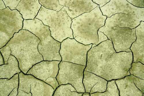
However, it will often be difficult to separate in practice these three levels of meaning, because interpretation will vary with cultural background and also because the levels may overlap to some degree (Chandler, Citation2017). Nevertheless, the African desert landscape in may tentatively serve as an example. The denotative meaning of this image would simply be a dry landscape with cracked soil, and the connotative meaning could refer to nature under threat through overexploitation. The mythical meaning would be related to the historically manufactured idea of ‘desertification’ (Benjaminsen & Berge, Citation2004).
This is an old colonial trope originally linked to European perceptions of environmental degradation, such as overgrazing, deforestation, soil erosion, and general careless mismanagement by African smallholders. is an example of an iconic image that efficiently transmits ideas of desertification conveying variegated associations to its viewers depending on their knowledge and background. Yet, among most observers, the photograph will generate the idea of desert encroachment (in Africa) caused by local mismanagement or climate change, or both in combination. This is also an idea that tends to resist empirical evidence, such as the fact that the drylands in the Sahel have become greener during the last 30 years (Benjaminsen & Hiernaux, Citation2019).
Myths move beyond connotation, because they are taken for granted and not questioned. In this way, myths have much in common with crisis narratives that also resist empirical knowledge that goes against their storyline (Roe, Citation1999). As Barthes points out, myths are depoliticised stories that work to conceal the ideological function of images. In , the hidden ideology would be a Eurocentric, Malthusian and neo-colonial view of African landscapes and their users, thereby contributing to the justification of the use of strict measures to arrest desertification—through fines, restricted use, and sometimes violence.
Figure 1. Cracked clay is an image often used to depict desertification. This is usually soil which cracks after having been flooded. Clay is often found in the lower parts of the landscape in the Sahel. These areas are flooded in the rainy season before they dry up in the dry season. When searching Google Images for ‘image desertification’, various similar photos of cracked clay are offered. Especially around the annual World Day to Combat Desertification (17th June), such images accompany articles on desertification published on websites and in printed media on a global scale
In the following sections, I will present three cases in which images are used to communicate an environmental myth. All three examples are based on my own empirical research and concern alleged pastoral mismanagement of the environment: ‘desertification’ associated with pastoral overgrazing in the West African Sahel, fence-line contrasts as evidence of pastoral degradation in communal areas in South Africa, and the use of satellite images to support a narrative of overstocking in Sámi reindeer herding in northern Norway.
In these three examples, various images are also used as powerful tools to ‘problematise’ (sensu Li, Citation2007) indigenous pastoralism, whereas technical measures, such as implementing carrying capacities or planting trees, are presented as solutions eventually leading to pastoralists being dispossessed of grazing land. As we shall see, iconic images are used as a tool to control pastoral land-use in the examples given from both the Global South and North. In all three cases, images as rhetorical devices have played a crucial role in transmitting the myths associated with the narratives on which policymakers tend to base their decisions.
Depicting desertification in the Sahel
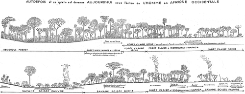
Aubréville (Citation1949) represents an early expression of the method of depicting historical landscape change in the Sahel (). He simply drew the changes he claimed were occurring.
André Aubréville was appointed as the first Head of the Forest Service of French West Africa in 1939—a post he occupied until his retirement in 1955 (Tassin, Citation2015). Under his leadership, the Forest Service institutionalised the idea of desertification caused by local land-use practices in the West African Sahel. This served to justify the Forest Service assuming control of forest resources and imposing rules on their use. In the colonial crisis narrative, indigenous people’s values and land management practices were depicted as backwards, unproductive, and deleterious to the Sahelian ecosystem (Benjaminsen & Hiernaux, Citation2019). In this way, Aubréville’s drawings helped transmit the message of a threatened ecosystem.
is an example of a drawing that was included in his seminal book ‘Climate, Forests and Desertification in Tropical Africa’ (Aubréville, Citation1949). These drawings were intended as illustrations of on-going changes in forest and savanna ecosystems at the time. Aubréville clearly saw the drawings as important to transmit the message of ecosystems under threat from local land-use practices. They are of a large size in a format that can be folded into the book. At three places in the lower drawing, Aubréville’s perceived indications of the degrading effect of bush fires (feux de brousse) can be seen. Nevertheless, at this point in time, desertification had not yet attained the status of myth, although Aubréville was one of the early influential academic contributors to establish desertification as an iconic environmental threat.
Figure 2. Forest landscapes of the past (above) and present (below) as a result of human-induced degradation in West Africa, according to Aubréville (Citation1949)
A few decades later, with the droughts in the Sahel in the 1970s and 80s, desertification became known as an environmental issue of global concern, which gradually achieved a worldwide iconic status. Although comparisons of aerial photos and satellite images over time soon came to undermine this idea (Helldén, Citation1991; Tucker, Dregne, & Newcomb, Citation1991) demonstrating in contrast that most of the Sahel was ‘greening’ mainly due to increased rainfall (Dardel et al., Citation2014; Hutchinson, Herrmann, Maukonen, & Weber, Citation2005; Olsson, Eklundh, & Ardö, Citation2005), desertification has continued to live on as an institutionalised fact in the UN system, among international aid donors and African governments (Benjaminsen & Hiernaux, Citation2019; Davis, Citation2016).
Climate models diverge in terms of expected future rainfall trends in the Sahel, but on average they predict a slight increase in precipitation except to the extreme west (Mauritania-Senegal) where a decrease is predicted. While generally an increase in total rainfall seems most likely, but with a shorter rainy season and increased temperatures, uncertainty remains characteristic of climate scenarios for the Sahel (Biasutti, Citation2013; Giannini, Citation2016). In contrast, the most commonly mediatised prediction of climate change in the Sahel remains as a trend towards a warmer and more arid climate, which again would lead to desertification in the long term (Benjaminsen & Hiernaux, Citation2019).
In the 1970s, 80s and 90s, the literature on desertification in the Sahel was primarily focused on ‘overpopulation’ and the associated local ‘overuse’ of renewable natural resources. However, due to climate change, the desertification narrative has more recently become transformed into a blend of mainstream Malthusianism and concerns for the effects of global warming. Thus, the narrative reflects old debates from early in the 20th century about desiccation in the Sahel and the extent to which this was a process driven by atmospheric drying or indigenous land-use in terms of overgrazing and overcutting of trees (Benjaminsen & Hiernaux, Citation2019; Davis, Citation2016).
When this image of drying or of human-induced desertification is projected in international media or by development organisations, iconic photos of cracked earth () are typically used, or alternatively of a sand dune threatening a single tree or a cultivated garden. Presentations of such image-tropes are rarely specific about location, since time series from specific areas will tend to support the greening counter-narrative. While such images work to offer visual examples of ongoing degradation, they paradoxically remain abstract representations that cannot be located in space and time. Hence, the geographical and historical context of these images is rarely provided to the viewers.
Images of desertification currently serve to justify a continued fight against this perceived process through fund-raising for large-scale tree planting projects, such as the Great Green Wall. This project was launched at a Heads of State Meeting at the headquarters of the Organisation of African Unity in Addis Ababa in 2007. It aims to fight desertification by establishing a 15 km wide and 7100 km long green wall of trees from Senegal to Djibouti, and is funded by the Global Environment Facility to a sum of over 100 million USD. Furthermore, at the climate summit in Paris in December 2015, the project was promised another 4 billion USD from donors. The intention is that the trees will sequester carbon, thereby also helping mitigate climate change, in addition to arresting desertification.
However, the introduction of large-scale tree planting to stop desert encroachment and to green a dusty Sahelian landscape is not a new approach. Already in the mid-1930s, the British forester, E. P. Stebbing, proposed the establishment of just such a wall of trees (Benjaminsen & Hiernaux, Citation2019; Swift, Citation1996). Images of green trees planted in the desert clearly still hold sufficient visual power to resonate widely in global media. The connotative level of these images is to communicate that science and modern principles of sustainability, usually introduced by foreign or external experts, can save the environment from overexploitation and disaster.
For instance, the BBC can report that ‘Many of the social and economic problems in the Sahel can be linked to a process called desertification’ and that
overgrazing and deforestation are the primary causes of desertification and have turned vast swathes of the Sahel into dust. However, an ambitious afforestation programme known as the Great Green Wall aims to reverse this process.
Therefore, planting trees becomes a universal remedy to problem-solving in the Sahel. The BBC even speculates whether such large-scale tree planting can help increase the security in the region and undermine recruitment for ‘terrorist’ or ‘jihadist’ armed groups. This belief in desertification being one of the causes of the current insecurity in the Sahel is frequently repeated in popular media and policy documents (including in a recent documentary film produced by the Great Green Wall project: https://www.greatgreenwall.org/film), while increasing support and adherence to armed groups can rather be explained by decades of poor and corrupt governance supported by foreign aid, leading to dispossession of smallholders and especially pastoralists (Benjaminsen & Ba, Citation2019). Hence, establishing green walls also becomes a way to depoliticise and to ‘render technical’ (Li, Citation2007) a deeply political problem about governance, as well as access to land and natural resources. Consequently, mythical images of desertification blaming pastoral land-use help to justify the dispossession of pastoralists whether through large-scale agricultural schemes or afforestation programmes.
Fence-line contrasts in South Africa
In South Africa, colonialism and apartheid resulted in large-scale land dispossession of indigenous people who were moved and confined to overcrowded reserves or ‘homelands’. After 1994, with the advent of democratisation, land reform became one of the key tools to redress the social injustices created by past land policies.
However, after 25 years of land reform, rural areas are still largely divided into two separate land-use systems: a ‘white’ and ‘commercial’ farming sector on large estates, and a ‘communal’ sector in the former reserves. In the drier parts of South Africa, such as in the Northern Cape Province, livestock, usually sheep, are kept in both of these systems. Farmers on the large private estates and in communal areas operate within the same ecological environment, but with contrasting management aims. Communal farmers continue to use a system based on kraaling at night (keeping livestock in enclosures) and herding during the day, in contrast to the commercial ranches, which are divided into several camps by fences, and in which livestock are rotated among these camps (Benjaminsen, Rohde, Sjaastad, Wisborg, & Lebert, Citation2006; Benjaminsen, Kepe, & Bråthen, Citation2008).
This results in the communal system being more labour-intensive, whereas the commercial system demands more capital investments in terms of fences and water points. Due to historical processes of land allocation and dispossession, communal areas also have a much higher density of people and livestock than the commercial farms, and consequentially, a substantially higher grazing pressure. Since land and available pastures represent a scarce resource for communal farmers, few manage to sustain their livelihoods only through livestock-keeping. They need to combine farming with other livelihood sources, such as wage labour or social security benefits. Therefore, the production aim is not only to produce meat, but also to keep livestock as a form of saving, which means keeping capital in reserve as a form of security for future expenses.
On the other hand, commercial farmers have meat production as the only management objective. Through controlled and stable stocking densities, they produce meat for the market with lambs being slaughtered after 4–5 months. This is a system focused on rapid growth of individual animals, while with less grazing resources available, the communal system depends on mobility in order to maximise herd productivity. While the productivity of individual animals is higher in the commercial system, the communal system has a higher area productivity. Production and pasture also remain more stable in the commercial system, whereas the communal system is marked by fluctuations associated with climatic events. While livestock-keeping in this semi-arid environment evidently has an impact on the vegetation, it is not clear that it leads to ‘degradation’ (Benjaminsen et al., Citation2006).
In the 1960s, a national stock reduction scheme was established by the Apartheid government in response to the perception that pastures were generally degraded (Hoffman & Ashwell, Citation2001). Compensation and subsidies were paid to white farmers to participate in the scheme through herd reduction. In addition, fences were erected between commercial and communal areas. Over time, with destocking on the commercial side of the fence and continued high livestock numbers on the communal side, contrasts in vegetation emerged along these fences, which are referred to as ‘fence-line contrasts’. Iconic photographs of such fence-line contrasts appear either as landscape photos () or as aerial photos. While the denotative meaning of such photos is a landscape divided by a fence with different types and quantities of vegetation on each side, the connotative meaning serves as a visual depiction of the contrast between two systems: one economically prosperous and environmentally sustainable, the other linked to poverty and environmental decline. Therefore, redistributing commercial farmland to communal areas is perceived by many as a possible conversion of landscapes from what is seen on one side of the fence to the other. Or such land reform would turn landscapes into ‘nothing’ (Hongslo & Benjaminsen, Citation2002). At the mythical level, such photos reproduce the long-held idea that African smallholders, and pastoralists in particular, tend to irrationally use landscapes and ecosystems leading to environmental destruction, and their land-use should therefore be guided and modernised by external experts.
Figure 3. Fence-line contrast. Photo: Anke Hoffmann
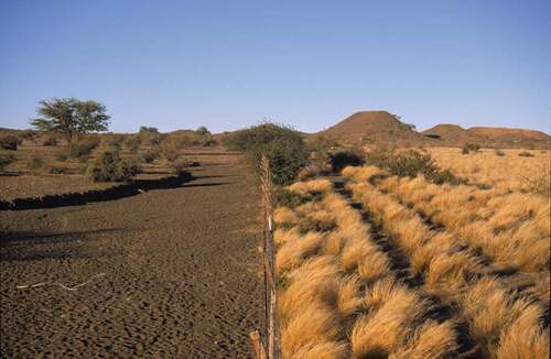
As pointed out by Hongslo (Citation2015), fence-line contrasts have actually been used as evidence of two opposing narratives, or connotative meanings, in debates about proper land-use and land reform in South Africa. In line with the tragedy of the commons argument, the first connotation says that communal tenure leads to environmental degradation and low economic production, thereby justifying the dividing of communal land into private units. In addition, livestock management on the new privatised farms should mimic the strategy followed on the large commercial farms with lower livestock densities and production of meat for the market. This has been a connotation subscribed to by the South African government during Apartheid, and also after democratisation, since at least the early 2000s as well as by powerful actors in agricultural development and environmental conservation. This connotative meaning has to some degree guided the implementation of land reform in the country (Benjaminsen et al., Citation2006). It has also been used to mobilise support for protected area expansion at the expense of land reform (Benjaminsen et al., Citation2008).
The second connotation says that pastoral degradation is a result of unequal land distribution, which has led to an overstocking of communal areas. While the first connotation has dominated development thinking in South Africa for many decades, the second has been adhered to by parts of the anti-Apartheid movement. It has been used to argue for smallholders’ rights and to highlight ‘the inequalities of a system where black and coloured farmers were restricted to small portions of the country’s land’ (Hongslo, Citation2015, p. 352). Hence, while the first connotation tended to relate degradation on communal land to African culture as well as to population growth, the second turned this argument around and blamed Apartheid policies for the alleged environmental degradation (Beinart, Citation1996; Hongslo, Citation2015). However, the second connotation has not questioned the idea of degradation itself, or that fence-line contrasts are evidence of overstocking.
The first connotation is clearly based on a myth of environmental destruction caused by African pastoralists, which photos of fence-line contrasts have played a key role in communicating to policymakers and the public at large, not only in Southern Africa, but also internationally. However, since myths work to conceal the ideological meaning of images, and since the second connotation is exactly about politicising fence-line contrasts, it is less evident that this connotation can be connected to a myth.
Satellite images as evidence of ‘overstocking’ in Sámi reindeer husbandry in Norway
Reindeer husbandry is the primary livelihood for over 20 ethnic groups in the Arctic and Sub-Arctic. In Norway, Finnmark in the far north is the largest reindeer-herding region, with 150,000–200,000 reindeer and about 2,150 reindeer owners of Sámi ethnicity (Benjaminsen, Eira, & Sara, Citation2016). Across most of Norway, reindeer herding is reserved for people of Sámi ethnicity, and access to this industry is regulated through a system of licences to restrict the number of pastoralists.
Reindeer pastoralism is based on a pattern of seasonal migrations. In Finnmark, these migrations take place between the mountainous winter pastures of the inland, which are dominated by lichen, and the green summer pastures on the coast. Annual migrations from winter to summer pastures can extend as far as 200–300 km in each direction.
For several decades, the Norwegian Parliament has held a cross-party consensus that overabundance of reindeer is the main driver of ecological degradation, land-use conflicts, and poor economic performance in this industry, leading to declining carcass weights and poor animal welfare. This consensus articulates a dominant narrative shared by politicians, government ministries, environmental organisations, most researchers, and the press (Benjaminsen et al., Citation2016, Citation2015; Johnsen, Benjaminsen, & Eira, Citation2015; Reinert, Citation2006).
Since reindeer husbandry is practised on 40% of the land area in Norway, there are a number of competing and overlapping land-uses, such as mining, windmill projects, municipal and state-led development of infrastructure, recreation activities, and conservation of carnivores. These land-uses have strong advocates, for example, in the Parliament, who see reindeer herding as an obstacle, which needs to be reduced in order to continue to develop Norwegian society. On the other hand, reindeer husbandry has hardly ever been represented in the Parliament.
Nevertheless, the notion that Sámi reindeer herders keep an excess of animals is not new. Since the end of the 19th Century, the state has periodically aimed at reducing reindeer populations. Initially, this was principally justified by the need to minimise land-use conflicts between pastoralists and sedentary farmers. However, during the last few decades, the size of the reindeer population has been restated as being primarily an environmental problem, a matter of overstocking, and the ecological impact of excessive reindeer populations. With the increased focus on environmental issues in the 1970s and 80s, ‘overstocking’ moved to the fore in Scandinavian research on reindeer management (Pape & Löffler, Citation2012). Along with this increased attention, the matter of excessive reindeer was also progressively configured as a technical problem, to be ‘solved’ through managerial interventions (Johnsen & Benjaminsen, Citation2017; Reinert, Citation2012).
The overstocking narrative supports a policy that has been in place since the 1980s, which concentrates on reducing reindeer numbers and the number of pastoralists by implementing set carrying capacities as the principal measure by which to achieve sustainability. These carrying capacities are said to be scientifically based, but have varied over time during the last few decades, indicating that these rates are to a large extent politically determined (Johnsen & Benjaminsen, Citation2017).
In empirical terms, the reindeer overstocking narrative in Norway is based primarily on time-series of satellite images of the lichen layers in Finnmark (Johansen & Karlsen, Citation1998, Citation2005). These time-series show a reduction in the area covered by lichen in the 1980s and 90s. In their analysis of reindeer pastures, Johansen and Karlsen (Citation2005) used satellite images from 1973, 1980, 1987, 1996 and 2000. They found that the lichen had covered one third of the area in 1973 and 1980, but—following a steady decrease—only 6% in 2000. During the same period, other vegetation types increased. Reduction in the quantity of lichen coincided with an increase in the reindeer population from the 1970s to around 1990. Although reindeer numbers decreased again in the 1990s (), the consensus among many scientists is that increased reindeer numbers are the principal cause of the observed reduction in lichen (e.g. Hausner et al., Citation2011; Johansen & Karlsen, Citation2005; Riseth, Johansen, & Vatn, Citation2004).
A report by Johansen et al. (Citation2014) reconfirmed these views strengthening public and political opinion in Norway about the need to destock reindeer populations, especially in Finnmark. The main conclusion in the report, widely publicised in the media, was that the lichen had covered 19% of the winter pastures in 1987, but only 4% in 2013. The ecological crisis on the Finnmark plateau was confirmed, and there was urgent need to adopt swift political action. This has further led to the implementation of a strict policy of quotas for each reindeer herding district and individual reindeer owners based on calculated carrying capacities. Exceeding these quotas leads to heavy fines and forced slaughter down to the required number of animals.
However, this study by Johansen, Tømmervik, Bjerke, & Karlsen, (Citation2014) is flawed in several ways. First, the study involved a number of questionable normative assessments by the authors. For instance, one of the mapped land-use categories is labelled ‘worn lichen pastures’ (slitte lavheier). These are lichen pastures above the tree line, and no dramatic changes in this category were detected over time. Yet, surprisingly, this category was not included in the estimates of changes in the lichen pastures. There is also the question of what ‘worn’ implies. What are the conditions of these pastures being compared to? Or, what is an acceptable amount of lichen and who decides what this amount should be? This is after all an old pastoral landscape in which reindeer pastoralism has been practiced for hundreds of years. Therefore, one should naturally expect a pastoral impact on the vegetation, meaning that the landscape is not an untouched wilderness.
In addition, and even more problematically, the loss of lichen cover only refers to a category called ‘lichen ground’ (lavmark). These are open areas below the tree line dominated by lichen. It is quite logical that this land-use category has decreased as there is encroachment of bushes and trees in the area, as in most mountain areas in Norway. Tømmervik, Johansen, Riseth et al. (Citation2009) found, for instance, a doubling of birch on the Finnmark plateau between 1957 and 2006. This is an ongoing process of landscape change all over Norway, which is usually attributed to climate change towards warmer and wetter summers sometimes in combination with reduced pastoral activity (Aas, Citation1969; Bryn, Citation2008). Despite this, in discussions of landscape change in the Sámi pastoral areas, this conclusion seems to be forgotten, and instead overstocking of reindeer is blamed.
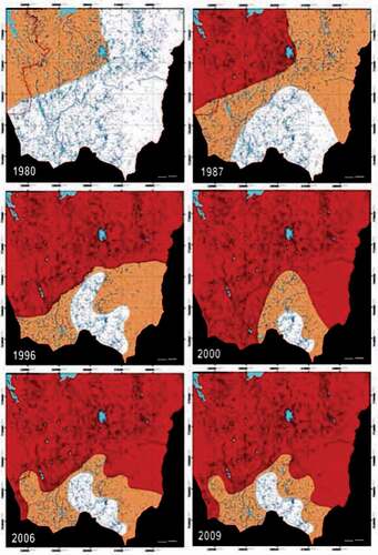
Based on the satellite data, simplified colour maps are made to illustrate the threat of overstocking. is such a map, which is reproduced from the most recent report of the office of the Auditor General (Riksrevisjonen, Citation2012, p. 51). In this figure, the complexities of the pastoral landscape are reduced to a rough colour map, with a large section in red labelled ‘overgrazed’ and a small, ever shrinking part in white labelled ‘intact’. Red is used as it is the colour of stop signs and danger. People also tend to respond emotionally to red (Monmonier, Citation1991).
However, one wonders what the baseline is of the notion of ‘intact’ being invoked here: an ‘original’ landscape from the 1970s, which would have remained exactly the same without reindeer pastoralism?
This figure is powerful as a political tool and is often used by ministers or government officials eager to demonstrate that there is an overabundance of reindeer in comparison to the grazing resources available. It efficiently communicates the perceived danger of overstocking—better than most written argumentation could. Moreover, since such maps are said to be based on scientific research, few people dare, or have the competence, to question them.
In his seminal book ‘How to lie with maps’, Monmonier (Citation1991) points out that maps are often used in political propaganda:
A good propagandist knows how to shape opinion by manipulating maps … The propagandist molds the map’s message by emphasizing supporting features, suppressing contradictory information, and choosing provocative, dramatic symbols. People trust maps, and intriguing maps attract the eye as well as connote authority. Naïve citizens willingly accept as truth maps based on a biased and sometimes fraudulent selection of facts. (p. 87)
Furthermore, Monmonier (Citation1991) adds that ‘most propaganda maps are little more than cartoons’ (p. 113). In particular, one should be suspicious when contrasting hues are used to demonstrate differences in intensity on choropleth maps. is a lucid example of a map that has been simplified to the level of a cartoon and used as scientific evidence in the Norwegian state’s political propaganda to reduce Sámi reindeer pastoralism to a minimum.
Figure 4. Overgrazing on the winter pastures in Finnmark according to Riksrevisjonen (Citation2012). The map is based on an updated version of time series from Johansen and Karlsen (Citation2005). Red = overgrazed, orange = moderately grazed; white = intact
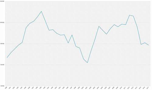
The state uses this map as its main piece of evidence of overstocking despite the ecological monitoring carried out by the Norwegian Institute of Nature Research (NINA) since 1998, which demonstrates that the lichen layer on the winter pastures has actually increased since this monitoring started. Results from the first comparative analysis (1998–2005) show that lichen cover had a marked increase from 1998 to 2005, from an average of 18.3% to 27.6% (Gaare, Tømmervik, Bjerke, & Thannheiser, Citation2006). Additionally, the thickness of the lichen layers increased from an average of 22 mm to 28 mm during the same period. Gaare et al. (Citation2006, p. 5) conclude that ‘today climate factors appear to be determinant for the continued development of the balance between reindeer and the pastures’. It is interesting to note that this conclusion and the positive increase in pastures in Finnmark occurred at the same time as the reindeer population of West Finnmark increased between 2000/2001 and 2005 ().
The second analysis based on the monitoring of pastures expands the time series until 2010 concluding that, during the period 2005–2010, there had been an overall decline in lichen coverage from 27.1% to 24.5% as well as a change in the average thickness of the lichen layer from 28 mm to 23 mm (Tømmervik, Johansen, Karlsen, & Ihlen, Citation2011). This occurred during a period when the reindeer population had continued to increase. Despite this decline, the lichen layer increased in both extension and thickness for the whole period investigated (1998–2010). Nevertheless, it is not surprising that the amount of lichen is reduced with more reindeer, although the relationship between reindeer and lichen is not linear, and climate variation also plays a role.
Hence, grazing inevitably affects vegetation with regard to both species composition and distribution, but despite the high reindeer numbers in 2010, there was no ‘ecological crisis’ on the tundra. This conclusion stands in contrast to the public and policy-based image given of reindeer husbandry in Norway leading to overgrazing, which is depicted in . The lack of scientific evidence for the overstocking narrative testified by the conclusions from this ecological monitoring and the above-mentioned problems with the analyses of satellite imagery, combined with the massive media and policy obsession with this narrative, demonstrate that the narrative of overstocking in Sámi reindeer pastoralism has taken the form of a myth in Norwegian society (Benjaminsen et al., Citation2016).
Figure 5. Reindeer numbers in Western Finnmark, 1980–2017
Conclusions
While narratives and metaphors have received a fair amount of attention in environmental discourse analysis, visual representations remain an under-studied object of research. Drawing on Barthes’ notions of denotation, connotation and myth in analyses of visual communication, I have provided three examples of the pivotal role of ‘degradation images’ associated with connotative meanings that sometimes, when taken for granted and not questioned, may be characterised as myths. The examples discussed are desertification in the West African Sahel, management of communal rangelands in South Africa, and debates about overstocking in Sámi reindeer husbandry in Norway.
In all three cases, iconic images are used in different ways to support a myth presented as a crisis narrative about pastoral mismanagement of the environment. In the case of alleged desertification in the Sahel, pastoralists are commonly blamed for overgrazing the range. This is part of an old belief that stems from early on in the colonial period. Currently, generic photographs of cracked soil frequently illustrate media articles about desertification, and the desertification myth continues to be communicated in the media and policy forums, despite the greening that has occurred during the last few decades. These stories and their degradation images provide the basis for policies and programmes aiming to control pastoral use, and to green the environment and mitigate climate change through tree planting initiatives that again may lead to dispossession of pastoralists from pastureland.
In the South African case, photos of fence-line contrasts are used as evidence of degradation and overstocking on communal land, which again is used to support an argument for destocking in communal areas and for communal farmers to mimic the production methods and objectives on private farms. Images of fence-line contrasts represent powerful visualisations of good (private farms) versus bad (communal areas) land management. Despite these images being questionable as scientific evidence, they continue to be employed as powerful tools informing policy formulation and implementation in Southern Africa and beyond.
Finally, in Norway, Sámi reindeer husbandry is practiced on 40% of the land area, resulting in a number of competing interests in the use of the land. These competing land-uses which view reindeer husbandry as an obstacle to achieve their aims, such as establishing a mine or a windmill project, tend to have strong advocates in Parliament and among politicians in general. This land-use competition has led to the myth in Norwegian society about the main problem with reindeer pastoralism being that there is overstocking of the range. In the construction of this myth, a colour map based on satellite images showing a decline of lichen on the winter pastures, has played a central role. While the map and the satellite analyses it is based on are scientifically weak, this does not disturb policymakers who continue with forced destocking of reindeer populations.
In all these cases, images are used as powerful tools to ‘problematise’ indigenous pastoralism, whereas technical measures, such as implementing carrying capacities, are presented as solutions, despite scientific evidence questioning the idea of general overstocking. In addition, we see that images as rhetorical devices have played a key role in all the cases producing the myths on which policymakers tend to base their decisions.
Acknowledgments
This text is written to honour Eirin Hongslo’s work and life. She sadly died in February 2017 when she was employed at the Norwegian University of Life Sciences as an Associate Professor. This article is inspired by her publications as well as by discussions we had during years of collaboration. I am also thankful for valuable comments on previous versions received from Synne Movik, Hanne Svarstad and Jørgen Alnæs, as well as from two anonymous reviewers.
Disclosure statement
No potential conflict of interest was reported by the author.
Additional information
Notes on contributors
Tor A. Benjaminsen
Tor A. Benjaminsen is a Human Geographer and Professor of Development Studies at the Norwegian University of Life Sciences. His research interests are environmental governance, land rights, pastoralism, and agrarian and environmental change. Using a political ecology approach, most of this research has taken place in Mali, Tanzania and South Africa, as well as in Norway. He is also a Lead Author of the sixth IPCC Assessment Report and an Associate Editor of Political Geography.
References
- Aas, B. (1969). Climatically raised birch lines in southeastern Norway 1918-1968. Norwegian Journal of Geography, 23(3), 119–130. doi:https://doi.org/10.1080/00291956908542805
- Adger, W. N., Benjaminsen, T. A., Brown, K., & Svarstad, H. (2001). Advancing a political ecology of global environmental discourses. Development and Change, 32(4), 681–715. doi:https://doi.org/10.1111/1467-7660.00222
- Anker, P. (2007). Graphic language: Herbert Bayer’s environmental design. Environmental History, 12, 254–278. Retrieved from https://pederanker.files.wordpress.com/2011/06/graphic-language-environmental-history.pdf
- Aubréville, A. (1949). Climats, forêts et désertification de l’Afrique tropicale. Société d’Editions Géographiques, Maritimes et Coloniales.
- Barthes, R. (1961/1977). Image, music, text. Hill & Wang.
- Barthes, R. (1972/2013). Mythologies. Hill & Wang.
- Bassett, T., & Zuéli, K. B. (2000). Environmental discourses and the Ivorian savanna. Annals of the Association of American Geographers, 90(1), 67–95. doi:https://doi.org/10.1111/0004-5608.00184
- Beinart, W. (1996). Soil erosion, animals and pasture over the longer term: Environmental destruction in southern Africa. In M. Leach & R. Mearns (Eds.), The lie of the land: Challenging received wisdom on the African environment (pp. 54–72). James Currey.
- Benjaminsen, T. A., & Ba, B. (2019). Why do Pastoralists in Mali join Jihadist Groups? A political ecological explanation. Journal of Peasant Studies, 46(1), 1–20. doi:https://doi.org/10.1080/03066150.2018.1474457
- Benjaminsen, T. A., & Berge, G. (2004). Myths of Timbuktu: From African El Dorado to desertification. International Journal of Political Economy, 34(1), 31–59. doi:https://doi.org/10.1080/08911916.2004.11042915
- Benjaminsen, T. A., Eira, I. M. G., & Sara, M. N. (eds). (2016). Samisk reindrift. Norske myter. Fagbokforlaget.
- Benjaminsen, T. A., & Hiernaux, P. (2019). From desiccation to global climate change: A history of the desertification narrative in the West African Sahel, 1900-2018. Global Environment, 12, 206–236. doi:https://doi.org/10.3197/ge.2019.120109
- Benjaminsen, T. A., Kepe, T., & Bråthen, S. (2008). Between global interests and local needs: Conservation and land reform in Namaqualand, South Africa. Africa, 78(2), 221–244. doi:https://doi.org/10.3366/E0001972008000144
- Benjaminsen, T. A., Reinert, H., Sjaastad, E., & Sara, M. N. (2015). Misreading the Arctic landscape: A political ecology of reindeer, carrying capacities and ‘overstocking’ in Finnmark, Norway. Norwegian Journal of Geography, 69(4), 219–229. doi:https://doi.org/10.1080/00291951.2015.1031274
- Benjaminsen, T. A., Rohde, R. F., Sjaastad, E., Wisborg, P., & Lebert, T. (2006). Land reform, range ecology, and carrying capacities in Namaqualand, South Africa. Annals of the Association of American Geographers, 96(3), 524–540. doi:https://doi.org/10.1111/j.1467-8306.2006.00704.x
- Biasutti, M. (2013). Forced Sahel rainfall trends in the CMIP5 archive. Journal of Geophysical Research: Atmospheres, 118, 1613–1623. doi:https://doi.org/10.1002/jgrd.50206
- Bryn, A. (2008). Recent forest limit changes in south-east Norway: Effects of climate change or regrowth after abandoned utilization?. Norwegian Journal of Geography, 62, 251–270. doi:https://doi.org/10.1080/00291950802517551
- Büscher, B. (2016). Nature 2.0: Exploring and theorizing the links between new media and nature conservation. New Media & Society, 18(5), 726–743. doi:https://doi.org/10.1177/1461444814545841
- Chandler, D. (2017). Semiotics for beginners. http://visual-memory.co.uk/daniel/Documents/S4B/sem06.html
- Charteris-Black, J. (2011). Politicians and rhetoric: The persuasive power of metaphor. Palgrave Macmillan.
- Dardel, C., Kergoat, L., Mougin, E., Hiernaux, P., Grippa, M., & Tucker, C. J. (2014). Re-greening Sahel: 30 years of remote sensing data and field observations (Mali, Niger). Remote Sensing of Environment, 140, 350–364. doi:https://doi.org/10.1016/j.rse.2013.09.011
- Davis, D. K. (2016). The arid lands. History, power, knowledge. MIT Press.
- Dryzek, J. S. (1997). The politics of the earth. Environmental discourses. Oxford University Press.
- Gaare, E., Tømmervik, H., Bjerke, J. W., & Thannheiser, D. (2006). Overvåking av vinterbeiter i Vest-Finnmark og Karasjok: Ny beskrivelse av fastrutene. NINA report. NINA. Retrieved from https://www.nina.no/archive/nina/PppBasePdf/rapport%5C2006%5C204.pdf
- Giannini, A. (2016). 40 years of climate modelling: The causes of late-20th century drought in the Sahel. In R. H. Behnke & M. Mortimore (Eds.), The end of desertification? Disputing environmental change in the drylands. Springer.
- Hajer, M. (1995). The politics of environmental discourse (pp. 265–291). Oxford University Press.
- Hajer, M., & Versteeg, W. (2005). A decade of discourse analysis of environmental politics: Achievements, challenges, perspectives. Journal of Environmental Policy & Planning, 7(3), 175–184. doi:https://doi.org/10.1080/15239080500339646
- Hansen, A., & Machin, D. (2013). Researching visual environmental communication. Environmental Communication, 7(2), 151–168. doi:https://doi.org/10.1080/17524032.2013.785441
- Hausner, V. N., Fauchald, P., Tveraa, T., Pedersen, E., Jernsletten, J. L., Ulvevadet, B., Ims, R. A., Yoccoz, N. G., & Bråthen, K. A. (2011). The ghost of development past. Ecology and Society, 16(3), 4. http://www.ecologyandsociety.org/vol16/iss3/art4/main.html
- Helldén, U. (1991). Desertification – Time for an assessment?. Ambio, 20(8), 372–383.
- Hoffman, M. T., & Ashwell, A. (2001). Nature divided: Land degradation in South Africa. UCT Press.
- Hongslo, E. (2015). An ecology of difference: Fence-line contrast photographs as scientific models in ecology. Journal of Political Ecology, 22, 339–356. Retrieved from https://journals.uair.arizona.edu/index.php/JPE/article/view/21112
- Hongslo, E., & Benjaminsen, T. A. (2002). Turning landscapes into ‘nothing’: A narrative of land reform in Namibia. Forum for Development Studies, 29(2), 321–347. doi:https://doi.org/10.1080/08039410.2002.9666210
- Hutchinson, C. F., Herrmann, S. M., Maukonen, T., & Weber, J. (2005). Introduction: The ‘Greening’ of the Sahel. Journal of Arid Environments, 63, 535–537. doi:https://doi.org/10.1016/j.jaridenv.2005.03.002
- Iedema, R. (2003). Multimodality, resemiotization: Extending the analysis of discourse as multi-semiotic practice. Visual Communication, 2(1), 29–57. doi:https://doi.org/10.1177/1470357203002001751
- Igoe, J. (2017). The nature of spectacle: On images, money, and conserving capitalism. University of Arizona Press.
- Johansen, B., & Karlsen, S. R. (1998). Endringer i lavdekket på Finnmarksvidda basert på Landsat 5/TM data. NORUT IT Rapport (IT475/1-98). Tromsø.
- Johansen, B., & Karlsen, S. R. (2005). Monitoring vegetation changes on Finnmarksvidda, Northern Norway, using landsat MSS and landsat TM/ETM+ satellite images. Phyocoenologia, 35(4), 969–984. doi:https://doi.org/10.1127/0340-269X/2005/0035-0969
- Johansen, B., Tømmervik, H., Bjerke, J. W., & Karlsen, S. T. (2014). Finnmarksvidda – Kartlegging og overvåking av reinbeiter. Status 2013. Rapport 7/2014. NORUT.
- Johnsen, K. I., & Benjaminsen, T. A. (2017). The art of governing and everyday resistance: “Rationalization” of Sámi Reindeer husbandry in Norway since the 1970s. Acta Borealia, 34(1), 1–25. doi:https://doi.org/10.1080/08003831.2017.1317981
- Johnsen, K. I., Benjaminsen, T. A., & Eira, I. M. G. (2015). Seeing like the state or like pastoralists? Conflicting narratives on the governance of Sámi reindeer husbandry in Finnmark, Norway. Norsk Geografisk Tidsskrift, 69(4), 230–241. doi:https://doi.org/10.1080/00291951.2015.1033747
- Larson, B. (2011). Metaphors for environmental sustainability: Redefining our relationship with nature. New Haven: Yale University Press.
- Leach, M., & Mearns, R. (eds). (1996). The lie of the land: Challenging received wisdom on the African environment. James Currey.
- Li, T. M. (2007). The will to improve. Duke University Press.
- Monmonier, M. (1991). How to lie with maps. Chicago: Chicago University Press.
- Olsson, L., Eklundh, L., & Ardö, J. (2005). A recent greening of the Sahel–trends, patterns and potential causes. Journal of Arid Environments, 63, 556–566. doi:https://doi.org/10.1016/j.jaridenv.2005.03.008
- Pape, R., & Löffler, J. (2012). Climate change, land-use conflicts, predation and ecological degradation as challenges for reindeer husbandry in northern Europe: What do we really know after half a century of research?. Ambio, 41, 421–434. doi:https://doi.org/10.1007/s13280-012-0257-6
- Reinert, E. (2006). The economics of reindeer herding: Saami entrepreneurship between cyclical sustainability and the powers of state and oligopolies. British Food Journal, 108(7), 522–540. doi:https://doi.org/10.1108/00070700610676352
- Reinert, H. (2012). The disposable surplus: Notes on waste, reindeer and biopolitics. Laboratorium, 4(3), 67–83. Retrieved from https://www.soclabo.org/index.php/laboratorium/article/view/52/166
- Riksrevisjonen. (2012). Riksrevisjonens undersøkelse av bærekraftig reindrift i Finnmark. Dokument 3: 14 (2011-2012). Retrieved from https://www.stortinget.no/globalassets/pdf/dokumentserien/2011-2012/dokumentbase_3_14_2011_2012.pdf
- Riseth, J. Å., Johansen, B., & Vatn, A. (2004). Aspects of a two-pasture-herbivore model. Rangifer, 15, 65–81. Retrieved from http://www.twodeadducks.net/rangifer/pdf/SI15-7Riseth.pdf
- Roe, E. (1991). Development narratives, or making the best of blueprint development. World Development, 19(4), 287–300. doi:https://doi.org/10.1016/0305-750X(91)90177-J
- Roe, E. (1999). Except-Africa. Remaking development, rethinking power. Transaction Publishers.
- Stott, P., & Sullivan, S. (eds). (2000). Political ecology: Science, myth and power. Arnold.
- Svarstad, H. (2009). Narrativitetens sosiologi. Sosiologi I Dag, 39(4), 29–56. Retrieved from http://ojs.novus.no/index.php/SID/article/view/1014/1005
- Swift, J. (1996). Desertification: Narratives, winners and losers. In M. Leach & R. Mearns (Eds.), The lie of the land: Challenging received wisdom on the African environment (pp. 73–90). James Currey.
- Tassin, J. (2015). André Aubréville (1897-1982), a pioneering forester and a visionary mind. Bois et Forêts des Tropiques, 323(1), 718. doi:https://doi.org/10.19182/bft2015.323.a31240
- Tømmervik, H., Johansen, B., Karlsen, S. R., & Ihlen, P. G. (2011). Overvåking av vinterbeiter i Vest-Finnmark og Karasjok 1998-2005-2010. NINA Rapport 745. NINA. Retrieved from https://brage.nina.no/nina-xmlui/handle/11250/2642782
- Tømmervik, H., Johansen, B., Riseth, J. Å., Karlsen, S. R., Solberg, B., & Høgda, K. A. (2009). Above ground biomass changes in the mountain birch forest and mountain heath of Finnmarksvidda, northern Norway, in the period 1957-2006. Forest Ecology and Management, 257, 244–257. doi:https://doi.org/10.1016/j.foreco.2008.08.038
- Tucker, C. J., Dregne, H. E., & Newcomb, W. W. (1991). Expansion and contraction of the Sahara Desert from 1980 to 1990. Science, 253, 299–301. doi:https://doi.org/10.1126/science.253.5017.299
- Veldhuis, M. P., Richie, M. E., Ogutu, J. O., Morrison, T. A., Beale, C. M., Estes, A. B., Mwakilema, W., Ojwang, G. O., Parr, C. L., Probert, J., Wargute, P. W., Hopcraft, C. G. C., & Olff, H. (2019). Cross-boundary human impacts compromise the Serengeti-Mara ecosystem. Science, 363(6434), 1424–1428. doi:https://doi.org/10.1126/science.aav0564