
ABSTRACT
Integrated coastal zone planning seeks to balance competing interests, with aquaculture representing an increasing pressure fuelled by a dominant discourse of ‘blue growth’. Recently, more regional-level approaches to planning and mapping in the coastal zone have emerged. Maps, however, are not neutral artefacts, but are infused with particular values and meanings, strengthening some interests rather than others. Drawing on a case study from Hordaland in western Norway, we demonstrate how mapping came to play a pivotal role in regional coastal planning – through analysing relevant documents and interviews, we explored how the conflicts between aquaculture and environmental concerns were explicitly visualised and brought to the fore through mapping. This triggered latent conflicts between the local and regional levels of governance, with several municipalities contesting the map. We suggest that the practice of mapping served to strengthen the authority of the regional planning body in mediating between conflicting interests.
1. Introduction
How should competing interests in coastal zones be dealt with? Coastal areas around the world are increasingly experiencing the pressures of more intense uses that have to be balanced against each other, and against the need for protection (Stepanova & Bruckmeier, Citation2013). These conflicts are fuelled in part through the recent reframing of the governance of marine and coastal spaces, shifting from an overarching concern with protecting marine environments to seeing the sea as a potential source of growth, which has given rise to a dominant discourse of blue growth or blue economy (Barbesgaard, Citation2018; Kidd & Shaw, Citation2014).
Aquaculture is an important element of this blue growth strategy (Barbesgaard, Citation2018). However, the industry has generated much controversy due to its environmental impacts, which are hard to regulate because decisions have to be made at multiple scales (McDaniels et al., Citation2005). Moreover, the fact that marine fish farms represent a partial privatisation of the coastal commons is raising concerns that aquaculture potentially is a form of ‘ocean grabbing’ (see, e.g. Barbesgaard, Citation2018; Knott & Neis, Citation2017).
Norway is experiencing an increasing pressure on its coastal areas, mainly due to a rapid growth in the aquaculture industry, which is largely taking place in the western and northern regions of the country. The aquaculture industry produces more than a million tonnes of farmed fish annually (Norwegian Seafood Council, Citation2016), and the Ministry of Trade and Fisheries argues that there is a potential for a five-fold increase in production by 2050, with an estimated value of 550 billion NOK (Ministry of Trade and Fisheries, Citation2015).
Regional and local coastal zone planning is increasingly emerging as a means to mitigate and mediate the escalating conflicts between aquaculture and other uses, such as recreation, fishing, and areas designated as being of particular protection value (Hovik & Stokke, Citation2007a; Stokke et al., Citation2006). Historically, local authorities have presided over and planned the use of the coastal commons that fall within their jurisdictions, but the need for planning at an aggregate regional scale is increasingly being recognised in response to contested commons in coastal waters (see, e.g. Hersoug & Johnsen, Citation2012) and mountain pastures (e.g. Hongslo, Citation2017). Conceptualisation of the ‘regional’ in the Norwegian context is tightly coupled with the idea of the county as a political-administrative unit, and the county council as the regional planning authority. However, limited formal authority has been given to the county council as planning authority, but the Planning and Building Act (PBA) from 2008 has put more emphasis on the regional level. This has coincided with another trend; that of increasingly viewing environmental issues as being in need of holistic and ecosystem-based approaches (e.g. Platjouw, Citation2016). Thus, while regional planning hitherto has had a rather weak status in Norwegian planning practice (Hovik & Stokke, Citation2007a, 2007b, Skjeggedal, Citation2005), this seems to be slowly changing. For the coastal regions, the adoption of integrated coastal management approaches involves integration, harmonisation, and achieving consistent policy to overcome the fragmentation inherent in the sectoral management approach, the splits in jurisdiction among levels of government and between different municipalities, and between terrestrial and marine areas (Bennett, Citation2001; Cicin-Sain & Knech, Citation1999; Kvalvik & Robertsen, Citation2017).
However, regional planning for marine and coastal areas differs in nature from the traditional land-based planning practices. For example, marine and coastal areas are biophysically radically different and are characterised by a much greater seasonal and temporal variation. They also have distinctly different property rights systems. While terrestrial planning is influenced by ‘deep cultural, historical and emotional attachment and sense of place’, these are not as well developed in marine areas (Kidd & Ellis, Citation2012, p. 51). While seascapes do invoke powerful emotional attachments in coastal communities and individuals, the ‘link between development and impact is far less visible, indeed, often completely hidden’ (Kidd & Ellis, Citation2012, p. 51). In addition, the knowledge related to mapping is much more limited in marine areas, compared to terrestrial areas. While doing fieldwork in Hordaland in the western part of Norway, we realised that the map resulting from the regional coastal planning process was triggering latent conflicts, rather than mediating them. This prompted our interest in understanding what role the map played in the planning process, how it was interpreted, and what ‘work’ it was doing.
Despite the increasing appreciation of the power-laden nature of mapping, as attested to by the growing body of work in critical cartography, there is surprisingly little research on mapping in landscape planning processes, as noted by Hongslo (2017), and there is little focus on the politics of mapping in the literature on integrated coastal zone planning. This paper therefore aims to contribute to filling these gaps through interrogating the role of mapping in a coastal regional planning process, how it was interpreted, and what purpose it served. Our focus is on the regional plan for one of Norway’s most interesting areas in terms of aquaculture production of salmon and trout, the western region of Sunnhordland and Ytre Hardanger (see ). While the region is at the forefront of farmed fish production, there are increasing concerns about the environmental impacts of this activity, particularly relating to the impacts on wild salmon stocks from densities of sea lice and farmed fish escapees (see, e.g. Movik & Stokke, Citation2015; Osmundsen & Olsen, Citation2017). Moreover, aquaculture potentially comes into conflict with established fishing rights and interests, as well as affecting biodiversity, recreation, and areas of landscape value.
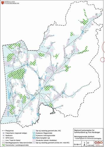
Figure 1. Regional map of Hordaland and Ytre Hardanger
The county council of Hordaland has developed a regional plan for the coastal areas of Sunnhordland and Ytre Hardanger that makes use of a regional map to identify two key issues, namely areas that can accommodate aquaculture, and areas of particular landscape value (landskapsområder). The purpose of this regional plan is to ensure sustainable development of sea areas and the associated shore areas, while also ensuring a reliable framework for the aquaculture industry. Despite the fact that the planning map is not legally binding, it has led to an intractable conflict with some of the municipalities in the region, with five of the 12 affected municipalities expressing significant disagreements to the regional plan. The intractability lies in the fact that the parties involved at the local and regional level were not able to reach a resolution, and therefore the case has been referred to the national level, that is, the Ministry of Local Government and Modernisation, for a final decision.
What is of interest here is the purpose that mapping serves in such a process. Maps are neither neutral nor objective but can be a powerful means to advance certain values and interests rather than others (Knol, Citation2011). For instance, Hongslo (2017), in her study of regional planning for wild reindeer mountain areas in southern Norway, demonstrated how maps were open to various interpretations, depending on the vantage point of the viewer. This paper engages with the diverse interpretations of mapping in a context of planning for the coastal commons. The questions we ask are: How is the map associated with the regional coastal zone plan interpreted by the actors involved? What role does it play in potentially reconstituting relations of authority in planning?
The paper is structured as follows: We begin by outlining key ideas and concepts linked to the politics of scale and critical cartography, drawing attention to how mapping co-constitutes space, and how this process of co-constitution of ‘map spaces’ (Del Casino & Hanna, Citation2005) highlight mapping as an instrument, or technology, of governance. We then describe the case of the regional planning process in Hordaland, focusing on key issues that emerged. We discuss these issues in light of our conceptualisations of maps as technologies of governance, stressing how the regional map became a symbol of strengthened regional authority. We conclude by reflecting on the implications of increasing use of maps in regional planning, arguing that this will likely challenge existing relations between the local and regional authorities in coastal planning.
2. Producing regional space: maps as technologies of governance
From merely being perceived as a simple hierarchy by political geographers, work on the politics of scale has highlighted how scale is socially constructed, and how it is fundamentally a relational concept (see, e.g. Brown & Purcell, Citation2005; Bulkeley, Citation2005; Delaney & Leitner, Citation1997; Norman et al., Citation2012; Swyngedouw, Citation2004). A thorough engagement with the politics of scale and practices of re-scaling and the associated re-framing of space requires a ‘critical analysis of the politics at play in the construction of these spaces’ argues Norman et al. (Citation2012, p. 54), emphasising that this involves ‘closer attention to the power nexus of who (or what) is included and excluded in the discussions and constructions of scale’ (p. 54).
The regional—often hierarchically situated between the local and the national—is one of the most diffusely defined geographical scales (Langeland, Citation2012). Etymologically, the term ‘region’ derives from the Latin term ‘regio’, which means to govern. A region is a broad and inclusive term; it can encompass everything from landscapes to levels of governance, as well as conceptions of areas that share a common history, identity, and culture. Mapping forms part of the social construction of regions, and it is therefore of interest to interrogate in more detail the way in which mapping practices contribute to particular conceptions of the regional in the context of regional coastal planning.
The understanding of what a map is and does has been transformed through the meticulous work of critical cartographers (see, e.g. Crampton, Citation2003; Kitchin & Dodge, Citation2007;Rossetto, Citation2016). To understand more thoroughly the relations of mapping and the construction of regional scales and spaces, we find it helpful to draw on Del Casino and Hanna’s work. They argue that maps and spaces are co-constitutive, proffering the term ‘map spaces’ as a way to bridge the binaries of representation and spatial practices, such as conceptualisation and interpretation. Map readers engage in their own, continuous interpretations, shaped by context, experience, and intertextual references (Del Casino & Hanna, 2005). This co-constitutive perspective on mapping has been further fleshed out by Kitchin and Dodge (Citation2007) who emphasise maps as emergent phenomena, stating that all engagement with ‘maps’ are emergent—all maps are beckoned into being to solve relational problems; ‘all are (re)mappings—the (re)deployment of spatial knowledges and practices’ (Kitchin & Dodge, Citation2007, p. 341).
The construction of map spaces involves processes of selection and demarcation, including some features while rendering others invisible (Kitchin & Dodge, Citation2007; Wood & Fels, Citation1992). Selecting particular legends, colour schemes, scales, and symbols involves subjective and value-laden decisions being made about what to include, how the map should look, and what it is communicating (MacEachren, 1995, Monmonier, 1996, as cited in Kitchin & Dodge, Citation2007, p. 332). Through such processes of selection, maps make particular propositions about the world (Wood & Fels, Citation1992, Wood, Citation2010), framing map spaces in particular ways. Maps thus function as technologies of governance; they are signifiers of governance choices (Lascoumes & Le Galès, Citation2007), imbued with specific ideas and values about landscapes and ecosystems—for example, in the way that ecological categories are made material through demarcations on the map (Knol, Citation2011).
Understanding maps and spaces as co-constitutive prompts us to consider the nature of authority and power. Space plays a central part of any political project (Branch, Citation2011), and maps often carry an air of authority (Hauck et al., Citation2013). Reflecting on the creation of the modern nation state, Branch (Citation2011, p. 2) observes that some of the fundamental features of modern political structures can best be understood as the ‘result of the cognitive and social impact of cartography’, noting how political authority came to be expressed in terms of homogenous territorial, bounded areas, marginalising other forms of authority. He goes on to argue that ‘a mutually constitutive relationship exists between representations of political space, the ideas held by actors about the organization of political authority, and actors’ authoritative political practices manifesting those ideas’ (Branch, Citation2011, pp. 3–4). Power is an amorphous term, and much of the literature on critical cartography is inspired by a Foucauldian notion of power as an immanent force, a productive and creative phenomenon (Burchell et al., Citation1991; Foucault Citation1980; Wood, 2010). Understanding mapping as contextually co-constituted, within individual, collective, and institutional frameworks, and how mapping does ‘work in the world’ (Kitchin & Dodge, Citation2007, p. 342) foregrounds the all-permeating nature of power in such practices. Thus, in adopting a view of map spaces as being co-constitutive, it makes little sense to try to isolate power as residing with the map-maker or as located in the map as object, but rather as a productive force that is intrinsic to the practices of mapping.
It is important, therefore, to better appreciate the dynamics at work that shape the nature of mapping practices, and to deepen our understanding of how maps become in the interface between making and interpretation, and what effects they have. Thus, we will draw on the insights from the scholarly literature on the politics of scale in combination with an appreciation of mapping as practice, as co-constitutive of map spaces, to understand how maps are interpreted and deployed in a particular coastal planning process.
In order to respond to the questions of how the map was interpreted and what its effects were, we analysed the content of the regional plan and the associated map. We read and critically analysed all the consultation letters submitted by the affected municipalities to the county council during the two consultation rounds, in 2015 and 2017. In addition, we carefully went through the letters expressing ‘significant disagreements’ that five of the municipalities sent to the Ministry of Local Government and Modernisation. These documents contained detailed descriptions of the municipalities’ perspectives on the plan, and thus offered rich empirical material that was supplemented with several semi-structured interviews with a regional planner in the county council, as well as interviews with planners from these municipalities and the consultants involved in mapping. Bearing in mind Kitchin and Dodge’s emphasis on ‘emergence’, we paid careful attention in our analysis of the documents and the interviews to the ways in which the map was interpreted by the different stakeholders and the significance of these interpretations for governance structures.
3. The practices and politics of regional coastal mapping: the case of Sunnhordland and Ytre Hardanger
3.1. Coastal zone planning practices
Before presenting the case in more detail, we find it judicious to offer a very brief background to the practices of coastal zone planning. As noted earlier, the municipalities are the primary planning authority approving legally binding plans for their territories, which includes the sea areas one nautical mile outside the baseline, according to the PBA 2008. However, a diversity of sectoral authorities also maintains responsibility for certain uses of coastal areas, and as has been indicated earlier, the regulation of aquaculture is particularly complex. To give a detailed description of the regulatory structures is outside the scope of this paper—suffice it to say that in order to gain access to a specific aquaculture site, permission has to be sought from a number of sectoral authorities, a process which is co-ordinated and managed by the county council, and which has to be in accordance with the municipal plan. Thus, local municipalities face a huge challenge in balancing local participation and planning with different sectoral interests (Frisvold & Rønningen, Citation2012). In terms of municipal planning for aquaculture, there are two main approaches; namely, detailed and flexible planning. A detailed planning approach involves identifying single-purpose areas for aquaculture, in the process taking account of other, potentially competing, interests and uses, such as transport, fisheries, recreation, and areas of particular nature value (Stokke & Arnesen, Citation2004). More flexible approaches involve an active use of the ‘multiple use’ areas including aquaculture (Hovik & Stokke, Citation2007a).
3.2. Preparing the revised regional plan
Sunnhordland in Hordaland county is one of Norway’s most important aquaculture regions, and Hordaland county council has targeted it as a pilot area for more detailed regional coastal planning. The regional planning process was formally initiated with the publication of the ‘Regional Planning Strategy for Hordaland for the period 2012–2016ʹ (Hordaland County Council, Citation2012). The next steps consisted in developing a programme for the planning work, including drawing up guidelines, identifying areas of particular interest, organising meetings with stakeholders, and gauging the need for strategic environmental assessments. Political and administrative ‘steering groups’ were set up, and several meetings were held. Open meetings were organised that focused on the four thematic areas of the plan, namely marine transport and industry, shore areas, aquaculture, and sustainable coastal planning. Meetings that concentrated more in-depth on the scientific issues associated with each of the thematic areas were also organised, as well as public consultation meetings on the draft plan itself.
There was an expressed desire on the part of the politicians to strengthen the role of the county council in coastal planning. This entailed enabling a more detailed approach to spatial planning that included mapping the coastal areas (interview regional planner, 16 October 2018), as the old plan from 2001 only contained written objectives and guidelines. Quite a lot of work had been done on collecting information on and making digitally available maps of the coastal areas in the region, which could provide a basis for the current planning process.
In order to strengthen regional planning, the PBA includes a statement that the county council can approve legally binding planning provisions. However, Hordaland county council opted not to do this because of the longstanding tradition in Norway that it is the local governments that make legally binding land-use plans. Instead, they emphasised that the map’s guidelines provide ‘directions for further municipal planning and strategic environmental assessments’. The significance of the map itself is emphasised, stating that the map ‘provides direction for municipalities’ planning considerations’ (Hordaland county council 2017, p. 47, authors’ translation).
Engaging in more detailed planning and mapping required external assistance. The county council hired Akvator, a consultancy company specialising in GIS, to produce the required maps. The company was later merged with Multiconsult AS, and some of the consultants involved later moved on to another firm, but it was largely the same group of people that were involved in data collection and mapping. The consultants tested new methods of mapping in cooperation with the county council and created a digital mapping portalFootnote1 to ensure openness and transparency. There was also a working group involving representatives from the municipalities and sectoral authorities, as well as a reference group. Two public meetings were held in early 2015 to inform about the ongoing work. In the process of producing the regional map, two issues, in particular, were viewed as key in order to balance aquaculture and other interests. The first was to analyse specific areas in terms of their suitability for aquaculture. The second issue involved identifying areas of particular landscape value (landskapsområder).
For the first issue, regarding the suitability of particular areas for aquaculture, the county council conducted its own area assessment to evaluate the potential for further aquaculture development. As part of this process, it hired the research institute Uni Research to analyse the impacts of sea lice, through monitoring sea lice mobility in the areas. However, the lack of accurate data on currents meant that this task was not possible to complete, and the level of ambition for area assessments was reduced. Thus, the assessment limited itself to developing a set of criteria linked to other uses of coastal areas, such as marine transport, industry, fisheries, recreation, landscape values, and cultural heritage sites. Defence interests and existing municipal plans were also taken into consideration. Based on these criteria, a table was created where each use was assessed in terms of its potential compatibility with aquaculture and categorised as red (not compatible), yellow (compatible depending on local conditions), or green (compatible). The table is reproduced in the regional planning document and contains only red and yellow categories. It formed a basis for identifying areas on the regional map that could potentially accommodate aquaculture in the future (i.e. yellow areas), provided that the current environmental impacts associated with aquaculture production are resolved.
The regional plan states that ‘Given the current situation of aquaculture’s environmental impacts, particularly on wild salmon stocks, there is little scope for increasing the production capacity within the planning area’ (Hordaland county council 2017, p. 29, authors’ translation). However, the plan cedes some ground to the aquaculture interests. Rather than imposing an outright ban on further adjustments and developments of existing and new localities, some flexibility is allowed. Such flexibility opens up possibilities for mitigating existing environmental impacts through shifting production sites, laying fallow some areas while others are kept under production. This flexibility accommodates possible future expansion if fish farmers manage to substantially reduce their environmental footprint.
Thus, while the regional plan is quite clear that, given existing practices and conditions, no further expansion should be encouraged, it still tries to strike a balance between protection and production. It caters to the interests of the aquaculture industry through providing some leeway, opening up the possibility for future growth if new technological innovations allow for a reduction in current environmental impacts.
The second main issue in the mapping exercise involved identifying areas of particular landscape value considered to be of regional and/or national importance. These landscape areas were closely associated with areas of considerable biodiversity, recreational and landscape value, and cultural heritage sites. The idea was to be able to map contiguous coastal areas considered of value in the region in an integrated way, incorporating coastal and shore areas. The aggregate regional map (cf. ) identifies 14 such landscape areas. It is explicitly stated that the identification of such areas does not constitute protection, but that the areas should be given ‘due consideration in municipal planning processes’ (Hordaland county council 2017, p. 22, authors’ translation). Initially, the mapmakers wanted to use ‘areas of special consideration’ as a category, which they deemed to be more appropriate, but this option was ruled out by the Department of Local Government and Modernisation (interview map consultants 16 September 2019).
The aggregate map shows areas that can potentially accommodate aquaculture (shaded in blue and pink), 14 areas that have been identified as having particular landscape value (shaded bright green, as specified by the national standard on mapping categorisations) in addition to other uses, such as existing aquaculture localities (shaded pink), fairways, and ports. A translation of the most important parts of the map legend is provided above. The green shade clearly dominates the map, and one has to look quite closely and carefully in order to discern where areas that could possibly accommodate aquaculture are located.
3.3. Consultations and reactions
The first public consultation of the plan was carried out between May and October 2015, but due to a change of political leadership both at the county level and within some of the municipalities, a new, somewhat restricted, round of public consultation was held for the revised plan between February and May 2017. A total of 43 responses were received during the first round, eight from affected municipalities, six from regional government agencies, three from other regional bodies, 17 from companies and associations, three from households/individuals, and the remaining four from law firms and local level political party representatives. The second round elicited 21 responses, 10 from municipalities, four from government regional bodies, and five from companies, in addition to two other associations. After the second round, the county council extended the areas identified as suitable for aquaculture, while at the same time reducing some of the areas set aside as landscape areas. These adjustments were made in response to comments from several municipalities and representatives from the aquaculture industry. The plan was approved by a narrow majority in the county parliament in early October 2017.
The adjustments were not sufficient to placate everyone; however, the map and attendant guidelines were still considered controversial. Five municipalities expressed ‘significant disagreements’Footnote2 and demanded that the plan be referred to the Ministry of Local Government and Modernisation for review and final decision. The Minister called a meeting on 9 March 2018 to discuss the case, inviting representatives from Hordaland county council and the five municipalities that had expressed ‘significant disagreements’, providing everyone an opportunity to voice their concerns. At the time of writing, a decision has yet to be reached regarding the status of the plan.Footnote3
Before embarking on the planning process, it was made clear that there would be a regional map to enable a more detailed planning of the coastal areas, which all parties were in favour of (interview with regional planner from the county council, 16 October 2018). However, attitudes shifted when the final result was made public. The 2015 municipal and county elections and the resulting change in political leadership in some of the municipalities played a part in this shift. What triggered the discontent was the map itself, more specifically, the areas on the map that had been designated as having particular landscape value, in conjunction with what was perceived as strongly worded guidelines. An excerpt from the guidelines reads as follows: ‘New areas for aquaculture and larger, permanent interventions should, as a general rule, not be allowed’ (Hordaland county council 2017, p. 50, authors’ translation).
Though the use of planning maps at the regional scale is not entirely new, it is still relatively unusual and not common practice, particularly for coastal areas. As a result, the status of the map was brought into question, with some municipalities ‘downgrading’ the map to being merely a source of information; a ‘background document’, which has been the practice before, rather than the outcome, or ‘future vision’, of a planning process (cf. Hongslo, 2017).
The plan is an assessment of the current situation and should therefore be regarded as an information document for future planning of coastal areas. It is natural that it is approved as an information document, and not as a plan.
(Letter from Tysnes municipality to the Ministry of Local Government and Modernisation 11 December 2017, authors’ translation.)
In the following, we focus on how different actors interpreted the map and the degree to which they perceived it as legitimate. A key complaint was that the map and guidelines represent an infringement on the autonomy of local municipalities as the primary planning body. Several municipalities and representatives from the aquaculture industry argued that the areas that had been identified as being compatible with aquaculture were too small to accommodate further expansion in the region, and thus that the map imposed restrictions on the municipalities’ ability to decide on the best uses of their coastal areas. This sentiment is reflected in the following quote:
It appears as if the county council desires to redefine the roles and responsibilities in today’s planning system … [for the regional plan] to become an overarching plan that intends to govern the municipalities’ internal decisions on how to make use of its coastal areas … taken in its totality, the regional plan appears as an undue intervention in the autonomy of the municipality.
(Letter from Tysnes municipality to the Ministry of Local Government and Modernisation 11 December 2017, authors’ translation)
Despite the emphasis in the regional plan that the map and guidelines are not legally binding and should be understood as providing direction and guidance for local planning, the five dissenting municipalities still argue that the plan and map go too far in instructing the municipalities. They note the extensive use of imperatives in the guidelines, such as ‘shall’ and ‘must’, and fear that the map and guidelines will be used as a basis for proposing objections to municipal plans in the future. Objections are the strongest means by which national and regional authorities can stop a municipal plan considered to be in conflict with national or regional interests. This worry is expressed in the following quote:
The municipality underscored in its letter to the county council during the consultation period that the regional plan should not be designed in such a way that municipal area decisions come into conflict with the regional plan, and that it should be designed in such a way that it could not be used as a basis for objections to municipal area planning decisions.
(Letter from Kvinnherad municipality to the Ministry of Local Government and Modernisation 13 December 2017, authors’ translation).
The objecting municipalities even questioned whether the county council, in drawing up a map with detailed guidelines, has overstepped its mandate. In a letter from Fitjar municipality to the Ministry (11 December 2017), the following is pointed out: ’The county council has … approved a regional plan with a content and a map that goes beyond the mandate it is given by the law’. The authors of the letter demand that the Ministry declare the plan null and void and suggest subjecting it to a new round of consultation after major revisions have been made. An alternative, as specified by several of the municipalities, is for the Ministry to expressly make clear that national and regional authorities cannot use the map as a basis for objections against future municipal plans.
The protesting municipalities received support from the Ministry of Trade and Fisheries. In a letter addressed to the Ministry of Local Government and Modernisation, they express their concern that regional plans are used as a means to potentially shift the ambit of responsibilities away from local municipalities towards regional authorities in planning affairs.
As we see it, if the maps are not firmly anchored at the municipal level, the planning competence will, for all practical purposes, be shifted away from the level of the municipality to the level of the county. We are doubtful that this is in line with the intention of the Planning and Building Act. According to the Jeløya-declaration, the aim of the government is to strengthen local autonomy and emphasise local democratic decisions in questions related to planning.
(Letter from the Ministry of Trade and Fisheries to the Ministry of Local Government and Modernisation, 3 May 2018, authors’ translation)
In response to the five municipalities questioning the legal status of the regional plan and the planning map, the county governor of Hordaland wrote a report on the matter, concluding that the plan does not represent any breach or misinterpretation of the law. In the report, the county governor stresses the view that coastal areas, in particular, have to be considered in a holistic manner across municipal borders (Hordaland county council 13 March 2018). Further, the governor points out that several of the municipalities demonstrate a lack of understanding of the role of regional planning according to the PBA.
The county council points out that regional planning maps are not new, referring to the regional plans for wild reindeer areas where maps are a central feature. In a recently published circular on laws and regulations for planning and resource use in coastal areas, it is clearly stated that regional plans can be developed with or without maps. The governor considers the regional plan for Sunnhordland and Ytre Hardanger as an important plan ‘because it clarifies the area needs of the aquaculture industry in relation to other uses in the coastal area and strikes a balance between protection and use in the interests of sustainability’. (Hordaland county council 3 September 2017, authors’ translation). The county governor expresses his disappointment concerning the fact that five municipalities do not regard the regional plan as a means of supporting their own planning activities. He emphasises that the county council nevertheless is empowered to approve the plan, even if not all the municipalities agree.
Thus, there are widely divergent interpretations and perspectives on the legitimacy of the map. While some see it as consolidating the current status, leaving little space for further development of marine aquaculture and other industries, others regard it as a functional holistic approach for guiding planning across municipal boundaries. It is seen as a necessary means to balance the area needs of aquaculture with other interests in the coastal areas, such as marine biodiversity, fisheries, and recreational uses.
4. The map as a symbol of regional authority
4.1. Narrowing down the room for manoeuvre
Developing regional plans with a regional planning map is a relatively novel phenomenon in the Norwegian context. The map was produced by external consultants, at the behest of the county council, and largely drew on existing data and available information, including from the municipalities. The processes of selecting what datasets to use, and the categorisation and demarcation of areas according to the sets of criteria, were mainly done by the consultancy company in collaboration with the county council. While the municipalities were initially positive towards the idea of drawing up such a map, there seems to have been diverging expectations of what the result would eventually look like.
The production of particular ‘map spaces’ and clear visualisation of the boundaries between areas that can be used for aquaculture and the 14 landscape areas considered of landscape value, which should not accommodate aquaculture, highlights how the map narrows down the room for manoeuvre open to the municipalities. Whereas the previous regional coastal plan, based as it was on text, allowed for some degree of discretion in terms of interpreting the text, the visual delineations of the map are essentially closing down that space for discretionary interpretation. The map powerfully brings out where the tension are with regard to protection versus production. Hence, using clearly identifiable designated landscape areas, demarcated with a bright green colour (cf. ), the discretionary decision-making power previously enjoyed by the municipalities is significantly constrained.
A response to this narrowing down of room for interpretation is that some of the municipalities questioned the very status of the map itself. Rather than viewing it as a guideline, as an outcome that they should strive to abide by in their local planning efforts, they instead argue that it is merely to be understood as an information document, as a basis that the municipalities can draw on, but not necessarily be guided by, in their own planning. Hongslo (2017) highlighted this tension between the map as a background document and the map as a future vision in her work on regional planning for wild reindeer areas. She points out that the use of maps in planning processes is ‘both descriptions of what is and what may be. Consequently, a map presented during a planning process is prone to be interpreted as both’ (Hongslo, 2017, p. 350). It draws attention to the ontological insecurity of the map, and the map as an emergent phenomenon, rather than an object—the map takes on its particular meaning as a map in the dialogue with the observer, who interprets it within his/her own particular contextual understanding.
The perception that the regional map infringed on the local government’s space for manoeuvre was clearly expressed in many of the consultation letters, and the feeling among the municipalities that they were being ‘bossed around’ by the county council was pervasive. Curiously, the fact that the plan is not legally binding did not seem to register with the municipalities opposed to what they see as a curbing of their powers.
4.2. Seeing like a county: creating regional ‘green’ coastal spaces
Whereas the local governments were concerned with their ambits of authority being circumscribed by the map, the county council, for its part, and the county governor, highlighted the necessity for ecologically sensitive and holistic planning as the main rationale for creating a regional map and viewed it as a means of securing areas of particular value. This holism is achieved through the careful selection, categorisation, and demarcation of coastal areas deemed to have particular value, and the subsequent cobbling together of these fragmented areas within each municipality to represent larger bodies of contiguous coastal ‘green’ spaces to be governed through regional guidance. Through the action of selecting and demarcating landscape areas, it creates new ‘map spaces’ associated with specific values and ideas of protection and safeguarding, it is making a claim that the areas outlined are in need of, or deserve, particular consideration and protective measures. Through this process, the county seeks to strengthen its own authority in coastal planning, where the central claim is that particular coastal spaces are better protected through regional-level governance. It does so, however, through a ‘soft’ approach, opting for guidelines rather than planning provisions, but is still met with fierce resistance by five of the 12 affected municipalities.
The county, in creating this map, tries to establish a new normative hierarchy (Harley, Citation1989), through privileging the contiguous landscape areas. The ‘stitching together’ of these areas is a form of claim-making, namely that only through safeguarding such spaces can a sustainable use of the coast be ensured—holism trumps fragmentation, and, by implication, the regional planning body, that is, the county council, should have overall authority, rather than the individual municipalities. The county council is thus attempting to solve what it perceives as a relational problem, that is, the fragmented nature of managing coastal spaces by municipalities, through emphasising the need to regard coastal spaces as regional, rather than local, and in need of more emphasis on protection, rather than development. The map, then, suggests to the municipalities that it is the county council that should have an overall responsibility. The municipalities, for their part, perceive the demarcations of the landscape areas to constitute area planning decisions, rather than mere guidelines. They regard the bright green areas designated as being of particular landscape values as an actual, rather than a suggested, infringement of their authority, ceding decision-making power to the regional instead of the local planning bodies. Thus, the practice of mapping produces new relations of authority and power in reconstituting the idea of local versus regional spaces through processes of inclusion and exclusion.
5. Concluding reflections
The practice of mapping as a co-constitutive process giving rise to ‘map spaces’ involves making claims that potentially impinge on existing relations of authority. They are technologies of governance that contain particular assumptions and values about the world, conveyed in overt and covert ways. The practice of mapping creates and constrains space—a central element of the regional planning map was how visualisation narrowed down the room for interpretation, or ‘discretionary spaces’, as alluded to above. The process of producing the regional map has re-cast old debates of protection versus production in a new form, through the construction of contiguous ‘green’ coastal spaces. The inherent claim is that the county is best equipped to govern such boundary-crossing spaces in a holistic and integrated way.
What are the wider implications of this? Our case clearly brings out the political power of mapping as means of re-scaling spatial planning and governance. Scales are produced through socio-political struggle, and the legitimacy and implications of the resulting scalar arrangement and associated re-framing of space hinges on the agendas of those empowered by it. In the current climate of dominant ‘blue growth’ discourses, it opens up avenues for wrestling with the scalar questions that are inherent in diverse actors’ struggles for power and control over marine and coastal resources. The practice of mapping regional coastal spaces forms part of actively producing a particular scalar arrangement, in the process prioritising particular ideas and norms of landscape values, protection, and development. Thus, it points to the power of mapping in co-constituting space and re-creating scalar arrangements and challenging and potentially reconfiguring existing relations of authority. Critical reflection and further research are needed to study the practices and outcomes of the potential re-scaling and re-territorialisation processes playing out in coastal and marine planning processes, and to what extent these critically engage with dominant ideas of ‘blue growth’.
Acknowledgments
We would like to thank our informants for taking time to respond to our questions, and our colleagues for useful inputs on earlier drafts of this paper, as well as constructive comments from two anonymous reviewers.
Disclosure statement
No potential conflict of interest was reported by the authors.
Additional information
Funding
Notes on contributors
Synne Movik
Synne Movik is Associate Professor in Environmental Planning at the Department of Urban and Regional Planning, Norwegian University of Life Sciences. Synne has a PhD from the Institute of Development Studies, University of Sussex, and did her post-doc at the Department of International Environment and Development Studies, NMBU. She has also spent some years working at the Norwegian Institute of Water Research. Her research interests span a broad range of themes within environmental governance and planning, including water, energy, coastal commons, and climate change. She has worked on water governance reform in Southern Africa, hydropower and development in Nepal and Tanzania, and how planning processes accommodate (or not) perceptions of landscapes and claims to resources of local fishing communities in India and northern Norway. She is particularly interested in questions around resource access, participation, and justice, and how conflicts over commons are framed.
Knut Bjørn Stokke
Knut Bjørn Stokke is Associate Professor at the Department of Urban and Regional Planning, Norwegian University of Life Sciences (NMBU). Stokke is a geographer who specialises in spatial planning. He has over 20 years’ experience conducting research on local and regional planning in coastal areas, river basins, and other local and regional contexts, first at the Norwegian Institute for Urban and Regional Research (NIBR), and the last 11 years at the Norwegian University of Life Sciences (NMBU). At NMBU Stokke has been co-responsible for master-level courses in Regional Landscape Planning and Community Development, with students from Urban and Regional Planning, Landscape Architecture, Nature Management and Nature-Based Tourism. One of his main concerns is to develop close synergies between research, teaching, and supervision. He is particularly interested in exploring questions around the conditions, opportunities, and constraints for facilitating integrated planning and management in a context of institutional fragmentation.
Notes
1. https://multiconsult.maps.arcgis.com/apps/webappviewer/index.html?id = f9a5ce9271464f0daee2cfb3719eaf32.
2. Whereas national and regional authorities and other municipalities can formally present significant objection (innsigelser) to a municipal plan according to the PBA, local governments that disagree with a regional plan can offer ‘significant disagreements’ (vesentlige innvendinger).
3. A decision was made after this article was submitted. The 14-page decision letter from the Ministry of Local Government and Modernisation, dated 20 March 2020, basically accepted the regional plan, but with multiple alterations that went a long way in accommodating the complaints from the local municipalities.
References
- Barbesgaard, M. (2018). Blue growth: Savior or ocean grabbing? The Journal of Peasant Studies, 45(1), 130–149. https://doi.org/https://doi.org/10.1080/03066150.2017.1377186
- Bennett, R. (2001). Kystsoneplanlegging etter Plan- og bygningsloven – Mot en integrert kystsoneforvaltning? Plan, 2, 22–27.
- Branch, J. (2011). Mapping the sovereign state: Technology, authority, and systemic change. International Organization, 65(1), 1–36. https://doi.org/https://doi.org/10.1017/S0020818310000299
- Brown, J. C., & Purcell, M. (2005). There’s nothing inherent about scale: Political ecology, the local trap, and the politics of development in the Brazilian Amazon. Geoforum, 36(5), 607–624. https://doi.org/https://doi.org/10.1016/j.geoforum.2004.09.001
- Bulkeley, H. (2005). Reconfiguring environmental governance: Towards a politics of scales and networks. Political Geography, 24(8), 875–902. https://doi.org/https://doi.org/10.1016/j.polgeo.2005.07.002
- Burchell, G., Gordon, C., & Miller, P. (Eds.). (1991). The foucault effect: Studies in governmentality. University of Chicago Press
- Cicin-Sain, B., & Knech, R. W. (1999). Integrated coastal and ocean management. In Concepts and practices. Island press.
- Crampton, J. W. (2003). The political mapping of cyberspace. Edinburgh University Press.
- Del Casino Jr, V. J., Del Casino Jr, J., & Hanna, S. P. (2005). Beyond the ‘binaries’: A methodological intervention for interrogating maps as representational practices. ACME: An International Journal for Critical Geographies, 4(1), 34–56.
- Delaney, D., & Leitner, H. (1997). The political construction of scale. Political Geography, 16(2), 93–97. https://doi.org/https://doi.org/10.1016/S0962-6298(96)00045-5
- Foucault, M. (1980). Power/knowledge: Selected interviews and other writings 1972-1977. Harvester Press.
- Frisvold, & Rønningen, K. (2012). Å ro uten årer. Om fylkeskommunens nye rolle i kystsoneforvaltningen’. In B. Hersoug & J. Johnsen (eds.), kampen om plass på kysten (pp. 121–137). Planlegging i kystsonen under nye betingelser. Universitetsforlaget
- Harley, J. B. (1989). Deconstructing the map. Cartographica: The International Journal for Geographic Information and Geovisualization, 26(2), 1–20. https://doi.org/https://doi.org/10.3138/E635-7827-1757-9T53
- Hauck, J., Görg, C., Varjopuro, R., Ratamäki, & Jax, K. (2013). Benefits and limitations of the ecosystem services concept in environmental policy and decision making: some stakeholder perspectives. Environmental Science & Policy, 25, 13–21.
- Hersoug, B., & Johnsen, J. (eds). (2012). kampen om plass på kysten Planlegging i kystsonen under nye betingelser’. Universitetsforlaget.
- Hongslo, E. (2017). Background information or future vision? Mapping wild reindeer landscapes in a planning process. Landscape research, 42(4), 349–360.
- Hordaland Council. (2012). Regional planstrategi for Hordaland 2012-2016. Hordaland county concil. https://www.hordaland.no/globalassets/for-hfk/plan-og-planarbeid/planer-pdf/regional_planstrategi_for_hordaland_20122016.pdf
- Hovik, S., & Stokke, K. B. (2007a). Network governance and policy integration – The case of regional coastal zone planning in Norway. European Planning Studies, 15(7), 927–944. https://doi.org/https://doi.org/10.1080/09654310701356647
- Hovik, S., & Stokke, K. B. (2007b). Balancing aquaculture with other coastal interests: A study of regional planning as a tool for ICZM in Norway. Ocean & Coastal Management, 50, 887–904. https://doi.org/https://doi.org/10.1016/j.ocecoaman.2007.05.003
- Kidd, S., & Ellis, G. (2012). From the land to sea and back again? Using terrestrial planning to understand the process of marine spatial planning. Journal of Environmental Policy & Planning, 14(1), 49–66. https://doi.org/https://doi.org/10.1080/1523908X.2012.662382
- Kidd, S., & Shaw, D. (2014). The social and political realities of marine spatial planning: Some land-based reflections. ICES Journal of Marine Science, 71(7), 1535–1541. https://doi.org/https://doi.org/10.1093/icesjms/fsu006
- Kitchin, R., & Dodge, M. (2007). Rethinking maps. Progress in Human Geography, 31(3), 331–344. https://doi.org/https://doi.org/10.1177/0309132507077082
- Knol, M. (2011). Mapping ocean governance: From ecological values to policy instrumentation. Journal of Environmental Planning and Management, 54(7), 979–995. https://doi.org/https://doi.org/10.1080/09640568.2010.547686
- Knott, C., & Neis, B. (2017). Privatization, financialization and ocean grabbing in New Brunswick herring fisheries and salmon aquaculture. Marine Policy, 80, 10–18. https://doi.org/https://doi.org/10.1016/j.marpol.2016.10.022
- Kvalvik, I., & Robertsen, R. (2017). Inter-municipal coastal zone planning and designation of areas for aquaculture in Norway: A tool for better and more coordinated planning? Ocean & Coastal Management, 142, 61–70. https://doi.org/https://doi.org/10.1016/j.ocecoaman.2017.03.020
- Langeland, O. (2012). Det regionale Norge 1950 til 2050. In G. S. Hanssen, O. Langeland, & J. E. Klausen (Eds.), Det regionale norge 1950-2050. Abstrakt (pp. 315–333). Abstrakt forlag.
- Lascoumes, P., & Le Galès, P. (2007). Introduction: Understanding public policy through its instruments—from the nature of instruments to the sociology of public policy instrumentation. Governance, 20(1), 1–21. https://doi.org/https://doi.org/10.1111/j.1468-0491.2007.00342.x
- McDaniels, T. L., Dowlatabadi, H., & Stevens, S. (2005). Multiple scales and regulatory gaps in environmental change: The case of salmon aquaculture. Global Environmental Change, 15(1), 9–21. https://doi.org/https://doi.org/10.1016/j.gloenvcha.2004.12.007
- Ministry of Trade and Fisheries. (2015). St.meld nr. 16, 2014-2015. Forutsigbar og miljømessig bærekraftig vekst i norsk lakse- og ørretoppdrett. https://www.regjeringen.no/no/dokumenter/meld.-st.-16-2014-2015/id2401865/
- Movik, S., & Stokke, K. B. (2015). Contested knowledges, contested responsibilities: The EU water framework directive and salmon farming in Norway. Norsk Geografisk Tidsskrift-Norwegian Journal of Geography, 69(4), 242–255. https://doi.org/https://doi.org/10.1080/00291951.2015.1061049
- Norman, E. S., Bakker, K., & Cook, C. (2012). Introduction to the themed section: Water governance and the politics of scale. Water Alternatives, 5(1), 52–61.
- Norwegian Seafood Council. (2016). Monthly statistics 2015.
- Osmundsen, T. C., & Olsen, M. S. (2017). The imperishable controversy over aquaculture. Marine Policy, 76, 136–142. https://doi.org/https://doi.org/10.1016/j.marpol.2016.11.022
- Platjouw, F. M. (2016). Environmental law and the ecosystem approach: Maintaining ecological integrity through consistency in law. Routledge.
- Skjeggedal, T. (2005). Ambitions and realities in Norwegian regional planning. European Planning Studies, 13(5), 731–748. https://doi.org/https://doi.org/10.1080/09654310500139582
- Stepanova, O., & Bruckmeier, K. (2013). The relevance of environmental conflict research for coastal management. A review of concepts, approaches and methods with a focus on Europe. Ocean & Coastal Management, 75, 20–32. https://doi.org/https://doi.org/10.1016/j.ocecoaman.2013.01.007
- Stokke, K. B., & Arnesen, O. E. (2004). Oppdrett og kommunal kystsoneplanlegging – Endring i planmetodikk? I Regionale trender 1/2004.
- Stokke, K. B., Hanssen, M., & Hovik, S. (2006). Kommunal kystsoneplanlegging. Et redskap for en balansert utvikling av havbruk og fiske. NIBR-rapport, 2006, 17.
- Swyngedouw, E. (2004). Scaled geographies: Nature, place, and the politics of scale. Scale and Geographic Inquiry: Nature, Society, and Method, 129–153. http://courseresources.mit.usf.edu/sgs/ang6469/canvas/module_3/read/Swyngedouw-case2.pdf
- Wood, D. (2010). Rethinking the power of maps. Guilford Press.
- Wood, D., & Fels, J. (1992). The power of maps. Guilford Press.