
ABSTRACT
Typomorphological analysis has been used to study building types, but it is seldom applied to open spaces. This paper argues that the same systematic and rigorous approach can be applied to define public open spaces. It explores the potential of the application of a systematic analysis of types and forms to define urban landscapes. Drawing on existing literature, this paper identifies specific attributes related to urban landscape elements including formal and spatial aspects. This paper highlights the potential of open space networks to respond to the contemporary challenges facing urban designers working to create better places to live in. This paper contributes to the field of design research through the development of a method of survey and analysis to inform design decision-making processes. Its significance lies in proposing a comprehensive framework to contribute to a more detailed definition of urban landscape character and inform the development of sustainable urban strategies.
Introduction
The present and future challenges of urbanisation require urban design practices, which are underpinned by robust theoretical frameworks as well as design tools and models (Montgomery, Citation2015, Thwaites et al., Citation2016). In past decades, there has been interest in ’design codes and guidance’ to inform urban planning and design (Carmona & Giordano, Citation2012; Carmona et al., Citation2006). However, there is a need to put more emphasis on the definition of public open spaces, which are often only superficially considered in design guidance more concerned with built forms (Erwin & Clemente, Citation2013; Studio REAL, Citation2013). Open spaces play an important role in defining landscape urban character and are instrumental in addressing key contemporary urban design issues, such as flooding and the urban heat island effect (Gill et al., Citation2007; Lenzholzer, Citation2015). Drawing on previous research (Pattacini, Citation2001, Citation2002, Citation2012; Samuels & Pattacini, Citation2014) this paper demonstrates how the typomorphological approach of urban analysis, which is usually applied to buildings, can be successfully applied to develop a framework of inquiry identifying the fundamental structure and principles of urban open space types and forms to contribute to knowledge and inform decision-making processes.
Following an historical overview of the different schools through the study of multilingual seminal texts, the paper provides a classification of urban open spaces identifying types based on the characteristics of their physical form and functions. The paper demonstrates the value of shifting the focus of the typomorphological from the field of architecture to the domain of landscape architecture through the classification of open spaces organised in relation to different scales of definition from entire settlements to individual urban landscape elements. The typomorphological approach also implies that processes and interactions will be considered including potential for adaptation and changes, which is particularly pertinent as designers respond to current concerns (e.g., flooding) to create resilient places. The paper shows how this ultimately leads to the development of a vocabulary to describe urban landscape and enables the identification, sorting and sequencing of heterogeneous fragments to identify patterns and organisational structures. Urban spaces are linked to uses and experience and therefore the systematic classification of physical characteristics is not considered a substitute for, but rather to complement more socially orientated approaches. The paper concludes by identifying the potential users of this investigation framework and the scope for application in practice.
Urban morphological, typological and typomorphological approaches and spaces between buildings: an overview
Key principles and application
Typomorphology is a strand of urban planning and design thinking first developed in Europe by urban geographers and architects. This analytical tool is concerned with the study of urban forms to enable a systematic classification of the elements constituting the urban fabric. Typomorphological analysis identifies commonalities and differences but also relates the forms and types to overall context and processes (Kropf, Citation2017; Oliveira, Citation2016). The aim is to interpret existing knowledge via a structured and critical investigation of design possibilities to develop a conceptual model to compensate for the lack of ‘design sciences’ (Moudon, Citation1989, p. 43) (Gauthier & Gilliland, Citation2006). In France, where planning is a legal system, which sets specific requirements and rules for new urban development, the typomorphological approach has led to clear parameters, which have informed practice in local plans (Pattacini, Citation2001; Samuels & Pattacini, Citation1997). Moudon (Citation1994, p. 308) argues that ‘A typomorphological approach yields a data base on the built landscape that can be used by various public entities charged with maintaining, upgrading and modifying it’. Others have demonstrated that even if typological classification cannot define absolute values, it can structure generic urban characteristics and establish relationships to inform practice (Kropf, Citation2017; Marshall & Gong, Citation2009).
Rossi (Citation1984) describes typomorphological analysis as thorough and precise in its definition but sufficiently open ended to offer multiple interpretations, allowing urban development choices and strategies to respect the identity of a place without imposing rules (Gu, Citation2014; Kropf, Citation2017). This reiterates de Quincy’s (1825/Citation1977) observation that types in architecture are mainly to inform and inspire, remaining vague and open to interpretation and therefore variation. For de Quincy, the type was not about an ideal standard to be copied but rather identifying an element from which to draw lessons. Muratori argues that this in-depth understanding of urban environments is essential to provide rigour in the design process (Cataldi et al., Citation2002). ‘Typomorphology’ is defined in this paper as drawing from both typological and morphological approaches. The term was coined by Carlo Aymonino to stress the dialogue and relationship between types and forms (Citation1966) and adopted by other scholars like Castex and Panerai in France (Citation1980), Moudon in America (Moudon, Citation1994), and more recently Chen and Thwaites (Citation2013). Moudon clarifies the term typomorphology as an approach considering ‘all scales of the built landscape, from the small room or garden to the large urbanized area’ considering urban forms as ‘a dynamic and continuously changing entity’ related to uses and users (Moudon, Citation1994, p. 289). This paper focuses on the material aspects of types using key urban landscape elements to propose a classification of open spaces and establish a functional and structural taxonomy (Kropf, Citation2017; Oliveira, Citation2016). This implies consideration of geometric and physical properties but also ‘relational typologies’ linking form and utility (Francescato, Citation1994; Pattacini, Citation2001).
The various schools and their consideration of spaces between buildings
A review of key publications linked to the different typological and morphological schools introduces the key principles of the various approaches related to typomorphology with a particular emphasis on landscape issues through the identification of references related to spaces between buildings ().
Table 1. Various schools related to typology, morphology and typomorphogy: Analysis of key publications (drawings by the author, redrawn from original)
The different schools of typomorphology are all concerned with the study of the urban environment, but they relate to different fields of enquiry and practice. Otto Schlüter, part of the German school, coined the concept ‘Morphologie der Kulturlandschaft’ (morphology of the cultural landscape) in Über den Grundriss der Städte (On the layout of towns, Schlüter, Citation1899). His work inspired German human geographers to study urban fabric using street patterns and open spaces in conjunction with the buildings to analyse stages of urban development (Hofmeister, Citation2004; Whitehand, Citation1981). They considered street orientation and profiles (Schlüter, Citation1899) and drew links between topography, water bodies, field patterns and street layouts. The plans include key features of medieval German cities: the town or market square and town walls. The German approach to urban morphology was disseminated in England through the Berlin born geographer M. R. G. Conzen and his seminal study of Alnwick (Conzen, Citation1960; Whitehand, Citation1981). Conzen referred to the ‘morphological frame’ constituting the study of the site, streets, blocks and plots and demonstrated the long-term influence of patterns related to old boundaries and circulation (Whitehand, Citation2001). On his drawings he always represented streets, squares and boundaries while vegetation was drawn on his more detailed plans. In other publications following the geographical tradition the elements relating to open spaces are considered intrinsic to site qualities including topography and water (Roberts, Citation1987).
The Italian school is concerned with architecture, cities and identity. The typological and morphological approach was used to inform city analysis and planning as an alternative to the more radical transformative ‘tabula rasa’ approaches dominating the post-war period in the 1950s and 1960s. The movement was led by Salvatore Muratori who undertook detailed urban form studies such as his seminal study of Venice and Rome (Muratori, Citation1959; Muratori et al., Citation1963). His aim was to move away from visual superficiality, identify good practice in the making of cities and apply the findings to inform design. His work focused on building types but included urban fabric and the notion of ‘urban organism’ emphasising the importance of continuity in urban development and the multidisciplinary nature of urban design including the consideration of open spaces (Cataldi et al., Citation2002). Other Italian architects adopted this approach of the understanding of the formation and evolution of the urban fabric and its components to inform urban planning strategies and policies (Cannigia & Maffei, Citation1979). This was successfully applied to create ‘contextual zoning codes’ to inform planning strategies for the city of Bologna (Cervellati et al., Citation1977; Moudon, Citation1989). Aldo Rossi also adopted the typological and morphological tool to identify geometrical characteristics defining archetypes to inform practice (Rossi, Citation1984). His concept of the ‘analogy city’ refers to traceable processes of urban evolution with key forms and elements to inform new design respectful of the existing urban character and identity. Types are used here to develop a coherent design language with specific vocabulary and grammar, which enable multiple compositions and variations. Rob Krier applies this to landscape architecture practice through his drawings of morphological variation of urban open spaces and his proposals for the reconstruction of Stuttgart using avenues to structure spaces and address thermal comfort (Krier, Citation1991).
The various studies on Italian cities inspired the development of similar practices in France through the work of urbanists at the Ecole d’Architecture de Versailles with a particular emphasis on multidisciplinary approaches to urban studies with the involvement of geographers and sociologists (Castex and Panerai, Citation1980, Panerai et al., Citation2012). As in the urban geographical tradition, they promote the consideration of the intrinsic qualities of the landscape such as topography, geological and flood data. Their analysis is structural and considers the function of public spaces and their hierarchical importance in the overall structure of a settlement (Panerai et al., Citation2012). They refer to key components of the urban ‘tissue’ (fabric): the street network, and the plot structure (Mangin & Panerai, Citation2009).
The various schools demonstrate the validity of the typomorphological approach to undertake systematic studies of towns and cities, and its potential to inform practice. However, this is limited to specific projects often related to preserving and editing historically significant urban environments. However, the bulk of urban design practices in the twenty-first century is related to ‘ordinary’ brownfield sites and therefore, there is a need to explore ways of using the typomorphological method of analysis and its application more widely,especially in relation to defining and creating spaces between buildings.
Developing an exploratory and informative method of investigation to define urban character
The approach builds on the work discussed above which considered network and types of constituting elements of public open spaces, namely streets, squares and open space infrastructure (Allain, Citation2004; Mangin & Panerai, Citation2009) and addresses the limitations highlighted above. The typomorphological scales of analysis are crucial to identify and illustrate the key elements of the spaces between buildings and their performance to create better places to live in. The first level is associated with what Rossi refers to as ‘the study area’ which he defined as an area with ‘physical and social homogeneity’ (Rossi, Citation1984 p. 64). Other terminologies include Piccinato’s ‘Zona’ (zone): an assembly of types and structure that gives a unitary character and vision to specific urban areas (Palermo & Ponzini, Citation2010) and Cannigia’s ‘tessuto urbano’ translated by the French school as ‘Tissu urbain’. In the Anglo-Saxon context the terms used are urban tissue or fabric including street network, plots related to land ownership and buildings (Conzen, Citation1960, Panerai et al., Citation2012). Kropf refers to ‘level of ‘resolution’ (Kropf, Citation2017). shows how the different levels of analysis are adapted here to define urban landscape character, while uses principles of plant taxonomy to propose a structured classification.
Figure 1. Examples of taxonomy of urban open spaces, based on shared characteristics (inspired by plant classification): (a) A taxonomy of streets (b) A taxonomy of squares
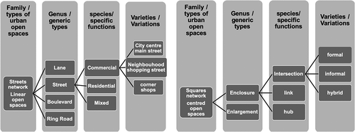
Table 2. Levels/scales of definition of urban tissue/fabric (adapted from Allain, Citation2004; Conzen, Citation1960; Kropf, Citation2017; Moudon, Citation1989, Citation1994)
Potential use of the proposed framework of analysis to inform sustainable urban design
The environmental impact of urbanisation and the need to seek modes of climate change mitigation is an ongoing debate in the field of landscape architecture and urban design (Haughton & Hunter, Citation1994; Steiner, Citation2019). The typomorphological approach of analysis can generate justification for urban strategies and proposals for future changes and provide a self-reinforcing and organising order to inform the quality of urban design practices (Shane, Citation2005). Urban regeneration projects imply repair of the urban fabric and integration of new interventions to create a more anthropocentric urban realm. The underlying premise of the exploratory and informative method of investigation proposed in this paper is to assist urban designers in the development of preliminary concepts and ideas offering a check list of components to consider.
As highlighted in the introduction urban analysis methods often focus on built forms, but greater considerations must be given to the spaces between buildings. Human settlements have historically been strategically located in relation to geographical locations (Cuthbert, Citation2011; Kostof, Citation1991; Mumford, Citation1961). The literature considers specific interventions related to urban forms and performance including thermal comfort, integrated water management, sustainable transport, carbon storage and sequestration and biodiversity (Lenzholzer, Citation2015). More specialised research, often related to engineering, may offer more quantifiable and accurate data based on modelling (Winter et al., Citation2019; Yuan, Citation2018). While the importance of methods of quantifying such impacts is not denied, this is a time-consuming process and requires involvement of specialists. As such this is not readily available to decision-makers, especially at the onset of planning/urban design projects. The framework proposed here not only provides a list of key considerations but also provides a strong rationale to inform strategic thinking and assessment of planning and design options related to open spaces characteristics and strategies. The choice of key parameters to consider spatial qualities and potential performances in relation to contemporary concerns in urban design draws on existing literature (). This includes criteria such as the percentages of the different surfaces covered, proportion of open spaces and tree cover to indicate the degree of positive or negative performance of an urban space in relation to climate, hydrology, carbon fixation and biodiversity (Whitford et al., Citation2001).
Table 3. Key themes/parameters to assess the performance of sustainable open spaces strategies and design options (Lynch et al., 2011; Hiremath et al., Citation2013; science for environment policy, 2018) and relevant publications (Bentley et al., Citation1985; Barton et al., Citation1995; Jacobs, 1999; Whitford et al., Citation2001; Haughton & Hunter, Citation1994; Marshall, Citation2009; Carmona, Citation2012; Wolfrum, Citation2015; Lenzholzer, Citation2015)
Types and forms of spaces between buildings─ characteristics and potentials
The systematic listing of essential components and considerations related to urban open spaces can help planners and designers develop an overarching understanding of options, potentials and suitability to articulate urban planning and strategic design thinking. The value of this proposed framework is not to replace existing method of survey and analysis but to offer a more systematic manageable approach to preliminary investigation of urban landscape characteristics. The next step is to consider the key scales of definition of urban spaces () and refer to the parameters listed in to consider potential qualities and limitations.
The wider scale: urban patterns
Urban patterns include wider contexts and constraints, but also size, density and grain (Lynch, Citation1954). There can be multiple pattern variations, but five main types of urban forms are identified: compact, linear strip/corridor, polynucleated nodal, scattered associated with various configurations of open spaces, as illustrated and described in (Lynch, Citation1981, Allain, Citation2004; Besussi et al., Citation2010). The location and spatial quality of spaces between buildings has an impact on city flows, including movement, water and wind, which are instrumental in achieving responsible, resilient living environments (Barton et al., Citation1995, Carmona & Giordano, Citation2012).
Table 4. Types of urban development; their characteristics and potential performance
Each location and site are unique and needs to be considered as such, but through the exploration of various types of basic patterns, it is possible to identify key principles to be taken into consideration for urban development. An important factor contributing to the urban landscape character is the proportion of built and non-built forms, often represented by figure-ground plans of cities (Jacobs, Citation1993; Wolfrum, Citation2015). This correlates with factors such as density and proportion of open spaces (Whitford et al., Citation2001). At this scale of definition, the other sustainability performance to weather comfort and water management includes the topography, green and blue infrastructure, urban patterns and networks of circulation. Vegetation and more specifically tree cover at city scale are also good indicators of urban quality, since trees provide a wide range of ecosystem services which play a major role in CO2 absorption, water management and urban climate (Leung et al., Citation2011; Wolff & Haase, Citation2019).
The points below explain the impact of location, size and quantities of open spaces on human comfort and quality of urban/natural systems. This is developed further in (Barton et al., Citation1995; Lenzholzer, Citation2015; Pattacini, Citation2012):
Cities often lie in valleys, leaving hilltops free from obstacles such as buildings and with dense planting to provide cool air flowing slowly downhill into the built area. Therefore, open spaces should preferably be positioned on high ground because cooler air is heavier and cannot travel up-hill.
Continuity of open spaces and/or a well-structured open spaces network/Green and blue infrastructures favour flows including wind/water/animal/plants and people. This is instrumental to mitigate the urban heat island effect by providing cool air circulation ensuring natural ventilation. Good distribution of open spaces favours slow airflow, preferable to strong powerful ones, which create discomfort.
Streets should preferably not be parallel to the dominant wind to avoid wind channelling and create uncomfortable environment. Buildings should not create obstacles between cooler and warmer areas.
Densely planted tall trees can mitigate the impact of tall buildings on wind force. Street trees can also reduce the wind channelling effect.
Street networks
Street networks are key to city structure, often remaining unaltered while the buildings aligning them change over time. They constitute the dominant framework of the public realm and provide visual order (Kostof, Citation1991; Marshall, Citation2009). Design code and guidance related to spatial characteristics of the street network and the streets are used to create strong urban identity (Carmona, Citation2010). Streets provide a spatial system of interrelated characteristics including position in the urban fabric, length and profile defined by width and characteristics of framing façades (Allain, Citation2004). The transitional spaces or thresholds between public and private realm are also key to the definition of the spatial qualities of streets. Previous publications have demonstrated the value of cataloguing comparable data related to street characteristics contributing to a better understanding of urban development and informing urban design strategies (Jacobs, Citation1993; Marshall, Citation2009). Street shapes, forms and patterns are diverse, these key characteristics and their potential are explored below.
Types of street network
The structural framework formed by a street network is a testimony of the urban development and evolution of the urban fabric (Whitehand, Citation1981). Le Corbusier identified two types of street network: the ‘Pack Donkey Way’ also referred to as ‘spontaneous’ influenced by natural constraints such as topography and water bodies. This is related to ‘desired lines’ of movement, which are easy, comfortable and direct. The ‘Man’s Way’ or ‘planned’ network implies geometrical pattern and engineered forms imposed on the contextual natural landscape of the settlement (Allain, Citation2004; Le Corbusier, Citation1929). The planned networks often follow sets of imposed rules, such as the Roman city axis or the Law of the Indies (Mumford, Citation1961) also responding to existing features such as fortifications or the requirements of engineered infrastructure (e.g., train lines) (Mumford, Citation1961). The increased use of the car also imposed new types of networks (e.g., ring roads), which are heavily engineered infrastructure, often breaking the fluidity and coherence of the original street network and creating ‘lost spaces’ (Trancik, Citation1986). The classification of types of street networks provides a useful tool to highlight the logic of organisation of its constituting elements as well as functionality, integration or non-integration of new elements in the existing urban fabric (Kropf, Citation2017; Mangin, Citation2004) ().
Table 5. Types of street patterns on le corbusier’s two types (Le Corbusier, Citation1929)
Type of streets, form and profile
summarises a classification of street types related to the density of movement and frequency of use (Eppell et al., Citation2001; Marshall, Citation2004). This forms an interconnecting hierarchy of street types (Karimi, Citation2012). Street orientation and the ratio between the width of the street and the height of the buildings defining the volume of the open space is key to the quality of the spatial experience (Chatzidimitriou & Yannas, Citation2017). Sun and wind exposure depend on the street orientation and the more spacious the width to height ratio the more air flows, avoiding the heat getting trapped Lenzholzer, Citation2015). A narrow ratio ensures more shade and therefore natural cooling, but also limits the amount of daylight penetrating the buildings. The canyon effect of a narrow street with tall buildings creates an uncomfortable wind tunnel effect, but streets, which are very wide with low buildings, will compromise the sense of place and enclosure of the linear space. A ratio of 1:1 and wider ensures more options and possibilities for the design of the street, including tree planting (Lenzholzer, Citation2015; Mangin & Panerai, Citation2009). The absence or presence of street trees is key to the streetscape character and to human comfort.
Table 6. A range of types of street sections
The plot subdivision and façades have an impact on the liveliness of the street. The narrower the plots and consequently the façades the greater the potential for animation along the linear space especially in the case of a commercial street. The width of pavement is key to enable extension of indoor activities out on the street, adding to its liveability value (Appleyard et al., Citation1981). Active frontages on the street are a necessity to ensure natural surveillance and footfall (Bentley et al., Citation1985, Llewelyn-Davies, Citation2007). Symmetrical double façades are the norm but asymmetrical layout provides greater diversity of experience, for example, if one side of the street is bordered by an open space or a waterfront.
Street design
The proportion of space allocated to cars versus other users is instrumental in defining a street character (). The allocation of space for vegetation is an important consideration. Street trees have high ecological value (Silvera Seamans, Citation2013), they mitigate heat stress through evapotranspiration and flood risks through water absorption (Lenzholzer, Citation2015). Dense canopies provide larger surface for fine dust and CO2 absorption, more shade and higher volume of evapotranspiration; high crowns enable cool air to circulate at ground level and deciduous trees maximise sun exposure in winter (Cantuaria, Citation2019).
The landscape design elements defining the threshold between public and private further define the spatial qualities of streets (). For example, the sheltered walkways formed by arcades, part of the building(s) but also of the streetscape, provide an effective transitional area often associated with commercial activities. The definition of the boundaries between uses and ownership can be materialised by various landscape design elements including integrated water management measures, such as sustainable drainage. In residential areas the boundaries of front gardens can take various forms including low walls, hedges and/or a change of surface material, which might be complemented with slight level changes. At detailed design level, the materials used to pave the streets can determine urban climate comfort as this is related to their thermal conductivity. Materials with high heat radiation, emissivity and conducting heat contribute to the heat island effect and higher air temperature (Li et al., Citation2018). Light and reflective surfaces can become blinding in the summer while rough irregular surfaces might affect the comfort of users (Lenzholzer, Citation2015). Finally, street furniture such as lighting and sitting opportunities add to the overall quality of the street design.
Table 7.. Street sections with pavement detail and elements for different types of streets and different widths (measurements based on Bentley, 1984; Jacobs, Citation1993; Marshall, Citation2009; Llewelyn- davies, Citation2007; Cameron et al., Citation2012)
Urban squares
Typical urban squares are open spaces surrounded by buildings, but similarly to the streets, they can also be bordered by other types of open spaces, such as a river or a park. Sitte defined squares as an enclosed space with a free centre associated with a monument on the perimeter and with attractive façades (Sitte, 1889). While the streets are mainly linear circulation places, squares are destinations and places of convergence. Lynch considers these spaces as ‘activity focused’ and places that ‘facilitate meetings’ (Lynch, Citation1981). They are part of a wider open space network and might fulfil a specific dominant function for the city giving the square its identity civic square or market square. The articulation of this ‘family’ of open spaces can be the consequence of incremental changes and development, which might have been planned to form a coherent series of squares with complementary functions. summarises the typomorphological characteristics of squares considering their qualities, potential and limitations in relation to connectivity, uses and climate comfort.
Table 8. Types of public squares
Types of squares: forms and volumes
There are three basic geometrical shapes: the square, the triangle and the circle (Krier, Citation1991). There are many variations of these types including the rectangular form, which might respond to specific proportional rules such as the golden section as prescribed in the sixteenth-century Laws of the Indies (Rodriguez, Citation2005). The variations can be further refined with consideration to the regularity and irregularity of the basic shape (Panerai et al., Citation2012). The spatial volume is defined by the square area related to the average height of the surrounding buildings. This determines microclimatic performance including solar and wind exposure, as well as topography and orientation. Another factor considered is the degree of enclosure of the square. This will have an influence on the square character and how it is perceived by users. If the perimeter is open by more than 25%, the enclosure is compromised (Krier, Citation1991). The visual and spatial connections with surrounding streets or spaces will have an impact on the legibility of the square and its perceived character of intimacy and monumentality ().
Table 9. Types of squares: spatial qualities and experiences in relation to permeability
Urban square design
The design and materiality of the square depend on three main elements: the characteristics of the ground surface, vegetation, built elements and special features, including water features. The topography of the ground, artificial changes of levels are key to define spatial qualities. The texture, colours and other characteristics of the materials used also contribute to the identity of the place (Llewelyn-Davies, Citation2007). The impact of vegetation and/or water can be more prominent than in streets in defining the character of the place because there is potentially more space for trees and water making their impact on microclimate greater. Furthermore, the visual impact is greater as it is an enclosed space with more diverse experiential qualities affected, for example, by the strategic positioning of an object such as a sculpture or fountain, which has the potential to create a strong focus point and attraction for users (Lynch, Citation1954).
Open space infrastructure
Different types of open spaces are considered including parks characterised by a larger proportion of their overall area occupied by soft, porous surfaces, planted areas and water. Different scales with different functions are considered. From pocket parks exemplified by the ‘London square’ forming a network of steppingstones throughout the urban fabric to amenity parks occupying a larger urban site with clear boundaries. In this category, we can distinguish variations related to urban development processes and location including historic parks and large central parks. A third category is the linear parks occupying a long and thin area going sometimes beyond the urban centres and acting as a connector with the urban fringes and often related to a river or disused railway lines (Allain, Citation2004). The link between different parks is often retrospectively driven by the contemporary concerns in creating coherent and continuous open space networks requirement to respond to the sustainable living agenda playing a major role in ensuring biodiversity and urban cooling (Barton et al., Citation1995; Haughton & Hunter, Citation1994). Parks also constitute a significant public amenity for urban dwellers and therefore should cater for a wide range of needs and activities. The size and location of parks, their isolation, proximity and/or continuity are criteria, which influence their potential impact on the quality of life in the urban environment (Swanwick et al., Citation2003). lists the characteristics of various types of network and their potential performance.
Table 10. Characteristics of various types of open spaces networks and their potential performance
Application
The framework of investigation explained above is a useful starting point in the exploration and assessment of urban characteristics considering the qualities and limitations of options for urban interventions focusing on open spaces. The strength of the proposed framework is to identify key components and parameters to influence decision-making processes in the inception phase of an urban project. The aim is to offer a framework for a rapid diagnostic of spatial qualities and limitations of all types of urban open spaces to enable decision-makers to rapidly consider options for consideration of urban strategies and interventions. provides an example of potential application.
Table 11. Illustration of potential application for urban investigation; three squares in sheffield
Potential users
The paper has outlined how typological and morphological approaches are primarily used by professional designers and applied mainly to the study of built forms with a focus on historically significant urban environments in response to conservation concerns. The investigation framework proposed in this paper aims to broaden the potential use and users of the approach implying that it can be used more widely by all decision-makers concerned with urban regeneration strategies and interventions. For example, it could inform the writing of design briefs and facilitate better understanding of the potential of different design proposals by enabling their comparison using the framework developed here. The following potential users and application are envisaged:
Professionals
Designers
Survey
Analysis of strength, opportunities and weaknesses
Rationale/vision
Preliminary concepts and ideas for the tender phase of a project or for a competition entry
Planners
Considerations of qualities and limitations of different options
Development of urban strategies including open space network and integrated water management.
Evaluation of proposals.
Policy makers
Inform the rationale for proposed urban development policies including new open spaces and location of new housing developments.
Non-professionals
Students
Introduce and increase understanding of the complexity of public urban open spaces network (types, qualities, limitations, potential).
Framework to guide the survey and analysis phase of a planning and/or design project.
Guidance to develop a rationale and vision to justify planning and/or design interventions.
Community groups
Provide a framework to inform public consultation processes.
Capacity building tool to help contributions to planning/design decision-making processes.
Conclusion
This paper explores the systematic characterisation of public open spaces. The method is generic and therefore cannot do justice to the uniqueness of places, but it aims to increase our knowledge and awareness of qualities of urban form. Such an investigation framework can go beyond the reading of the urban environment to become the basis for application in practice as a tool to support design processes. The investigation framework is pertinent to urban analysis, but also is meant to inform design. This promotes the idea of the designer as a craftsman relying on evidence and savoir faire to develop preliminary ideas, but also can be used by policy makers and non-designers to consider possibilities and options. It is a tool that should evolve and be refined through testing and application drawing on existing research and professional practice to respond to the specific conditions of the urban environment, the contemporary challenges and the needs of the users. At present its application has been limited to only a few projects and applied mainly by trained designers (Pattacini, Citation2001; Samuels & Pattacini, Citation2014). More reflection will be needed once applied more widely to inform students and community group projects to assess its full potential. Nevertheless, there is no doubt that the structured investigative framework, underpinned by its systematic and consistent considerations of key characteristics of urban open spaces has the potential to increase the understanding of and participation in urban design and planning processes. This approach can provide evidence to support a clear rationale, thereby helping to make the process of making design decision more transparent and coherent. Applying the typomorphological framework to public open spaces bridges the disciplinary boundaries, embracing the potential symbiosis between architecture and landscape. This is a prerequisite to understanding and successfully regenerating urban landscapes to respond to the sustainable agenda and create better places to live.
Acknowledgments
I would like to thank Nicola Dempsey for her continual support, encouragement and stimulating discussions. I also wish to thank Jan Woudstra for proofreading the text.
Additional information
Notes on contributors
Laurence Pattacini
Laurence Pattacini is an architect and urban designer, who teaches in the department of Landscape Architecture at the University of Sheffield. She is interested in spaces and life between buildings. Throughout her professional practice, research and teaching she explores new ideas and design approaches to meet the complex sustainability agenda.
References
- Allain, R. (2004). Morphologie Urbaine. Armand Colin.
- Appleyard, D., Gerson, M. S., & Lintell, M. (1981). Livable streets. University of California Press.
- Aymonino, C. (1966). L'etude ds phenomenes urbains. In La citta di Padova, Officina.
- Barton, H., Davis, G., & Guise, R. (1995). Sustainable Settlements: A Guide for Planners, Designers and Developers. UWE Bristol and LGMB.
- Bentley, I., McGlynn, S., & Smith, G. (1985). Responsive environments : A manual for designers. Architectural Press.
- Besussi, E., Chin, N., Batty, M., & Longley, P. (2010). The Structure and Form of Urban Settlement. In T. Rashed & C. Jurgens (Eds.), Remote Sensing of Urban and Suburban Areas (pp. 13-31). Springer.
- Cameron, R., Blanuša, T., Taylor, J., Salisbury, A., Halstead, A., Henricot, B., & Thompson, K. (2012). The domestic garden – Its contribution to urban green infrastructure. Urban Forestry & Urban Greening, 11(2), 129–137. doi:10.1016/j.ufug.2012.01.002
- Cannigia, G., & Maffei, G. (1979). Composizione Architettonica e Tipologia (Edilizia: 1). Lettura dell’ Edilizia di Base. Marsilio.
- Cantuaria, G. (2019). Vegetation and Environmental Comfort. In M. Guedes & G. Cantuaria (Eds.), Bioclimatic Architecture in Warm Climates (pp. 155-191). Springer, Cham.
- Carmona, M. (2010). Public places - urban spaces: The dimensions of urban design (2nd ed.). London: Architectural.
- Carmona, M., & Giordano, V. (2012). Design Coding Diffusion of Practice in England. UCL and Urban Design Group.
- Carmona, M., Marshall, S., & Stevens, Q. (2006). Design codes: Their use and potential. Progress in Planning, 65(4), 4. doi:10.1016/j.progress.2006.03.008
- Castex, J., Celeste P., & Panerai, P. (1980). Lecture d'une Ville: Versailles. Le Moniteur.
- Cataldi, G., Maffei, G. L., & Vaccaro, P. (2002). Saverio Muratori and the Italian school of planning typology. Urban Morphology, 6(1), 3–14.
- Cervellati, L., Scnnavini, R., & De Angelis, C. (1977). La nuova cultura delle città : la salvaguardia dei centri storici, la riappropriazione sociale degli organismi urbani e l'analisi dello sviluppo territoriale nell'esperienza di Bologna. Edizioni scientifiche e tecniche Mondadori.
- Chatzidimitriou, A., & Yannas, S. (2017). Street canyon design and improvement potential for urban open spaces; the influence of canyon aspect ratio and orientation on microclimate and outdoor comfort. Sustainable Cities and Society, 33, 85–101. doi:10.1016/j.scs.2017.05.019
- Chen, F., & Thwaites, K. (2013). Chinese urban design : The typomorphological approach (Design and the built environment series). Farnham: Ashgate
- Conzen, M. R. G. (1960). Alnwick, Northumberland: A study in town-plan analysis. Institute of British Geographers.
- Corbusier, L. (1929). The Pack-donkey’s way and the man’s way, The City of Tomorrow and its Planning. In M. Larice & E. Macdonald (Eds.), The Urban Design Reader (pp. 90–93). Routledge.
- Cuthbert, A. (2011). Understanding Cities; Method in urban design. Taylor and Francis.
- de Quincy, A.C.Q. (1825/1977), “Type,” In Encyclopédie Méthodique (Vol. 3, p.148). (T. Vidler, Trans.). Oppositions 8, Paris: Spring.
- Eppell, V. A. T., McClurg, B. A., & Bunker, J. M. (2001). A four level road hierarchy for network planning and management. In V. Jaeger (Ed.), Proceedings, 20th ARRB Conference (pp. 1-15). Melbourne.
- Erwin, R., & Clemente, O. (2013). Measuring Urban Design; Metrics for Livable Places. Island Press.
- Francescato, G. (1994). Type and the possibility of an architectural scholarship. In K. A. Franck & L. H. Schneekloth (Eds.), Orderning Space: Types in Architecture and Design (pp. 253–270). Van Nostrand: Reinhold.
- Gauthier, P., & Gilliland, J. (2006). Mapping urban morphology: A classification scheme for interpreting contributions to the study of urban form. In Urban Morphology10(1) (pp. 41–50).
- Geisler, W. (1918). Danzig: Ein siedlungsgeographischer Versuch. Druck von A.W. Kafemann.
- Gill, S., Handley, J., Ennos, A., & Pauleit, S. (2007). Adapting Cities for Climate Change: The Role of the Green Infrastructure. Built Environment, 33(1), 115–133. doi:10.2148/benv.33.1.115
- Gu, K. (2014). From urban landscape units to morphological coding: Exploring an alternative approach to zoning in Auckland, New Zealand. Urban Design International, 19(2), 159–174. doi:10.1057/udi.2013.21
- Haughton, G., & Hunter, C. (1994). Sustainable Cities. Routledge.
- Hiremath, R. B., Balachandra, P., Kumar, B., Bansode, S. S., & Murali, J. (2013). Indicator-based urban sustainability—A review. Energy for Sustainable Development, 17(6), 555–563.
- Hofmeister, B. (2004). The study of urban form in Germany. Urban Morphology, 8(1), 3–12.
- Huidong, L., Zhou, Y., Xiaoma, L., Meng, L., Wang, X., Sha, W., & Sodoudi, S. (2018). A new method to quantify surface urban heat island intensity. The Science of the Total Environment, 624, 262–272
- Jacobs, A. B. (1993). Great Streets. MIT Press.
- Karimi, K. (2012). A configurational approach to analytical urban design: ‘Space syntax’ methodology. Urban Design International, 17(4), 297–318. doi:10.1057/udi.2012.19
- Kostof, S. (1991). The City Shaped: Urban patterns and meanings through history. Thames & Hudson.
- Krier, R. (1991). (5th edition) Urban Space. Academy Editions.
- Kropf, K. (2017). The handbook of urban morphology (1st ed.). Wiley.
- Lenzholzer, S. (2015). Weather in the City. Nai010.
- Leung, D. Y. C., Tsui, J. K. Y., Chen, F., Yip, W.-K., Vrijmoed, L. L. P., & Liu, C.-H. (2011). Effects of Urban Vegetation on Urban Air Quality. Landscape Research, 36(2), 173–188. doi:10.1080/01426397.2010.547570
- Llewelyn-Davies, R. (2007). Urban Design Compendium. English Partnerships.
- Lynch, K. (1954). The Form of Cities. Scientific American, 190(4), 54–63. doi:10.1038/scientificamerican0454-54
- Lynch, K. (1981). A Theory of Good City Form. MIT Press.
- Mangin, D. (2004). La Ville Franchisee. Editions de la Vilette.
- Mangin, D., & Panerai, P. (2009). Projet Urbain (4th ed.). Parentheses.
- Marshall, S. (2004). Streets and Patterns. Spon Press.
- Marshall, S. (2009). Cities, Design and Evolution. Routledge.
- Marshall, S., & Gong, Y. (2009). SOLUTIONS research project, WP4 Deliverable Report: Urban Pattern Specification, Bartlett School of Planning University College London [accessed 06 Sept.2019].
- Montgomery, C. (2015). Happy city : Transforming our lives through urban design. UK: Penguin Books.
- Moudon, A. V. (1989). The role of typomorphological studies in Environmental Design Research, University of Washington. [accessed, 20(12), 19]. https://www.scribd.com/document/213737939/Vernez-Moudon-n-d-The-Role-of-Typomorphological-Studies
- Moudon, A. V. (1994). Getting to Know the Built Landscape: Typomorphology. In K. A. Franck & L. H. Schneekloth (Eds.), Ordering Space: Types in Architecture and Design (pp. 289–311). Van Nostrand Reinhold.
- Mumford, L. (1961). The City in History: Its origins, its transformations, and its prospects. Secker & Warburg.
- Muratori, S. (1959). Studi per una operante storia urbana di Venezia. Roma. Istituto poligrafico dello Stato.
- Muratori, S., Bollati, R., Bollati, S., & Marinucci, G. (1963). Studi per una operante storia urbana di Roma. Consiglio Nazionale delle Ricerche.
- Oliveira, V. (2016). Urban Morphology. An introduction to the study of the physical form of cities. Springer International.
- Palermo, P. C., & Ponzini, D. (2010). Spatial Planning and Urban Development: Critical perspectives. Springer.
- Panerai, P., Depaule, J.-C., & Demorgon, M. (2012). Analyse Urbaine (2nd ed.). Parenthèses.
- Pattacini, L. (2001). Landscape and Design Guidance: Saint-Gervais-les-Bains, a case study. Journal of Urban Design, 6(3), 319–327. doi:10.1080/13574800120105814
- Pattacini, L. (2002). Better Places to Live: Learning from The French Experience. Urban Design Studies, 8, 61–72.
- Pattacini, L. (2012). Climate and urban form. URBAN DESIGN International, 17(2), 106–114. doi:10.1057/udi.2012.2
- Roberts, L. (1987). The making of the English village. Longman.
- Rodriguez, R. (2005). The foundational process of cities in Spanish America: The Law of Indies as planning tool for urbanization in early colonial towns in Venezuela. Focus, 2(1), 47–57. https://doi.org/10.15368/focus.2005v2n1.8
- Rossi, A. (1984). The Architecture of the City. MIT Press.
- Samuels, I., & Pattacini, L. (2014). Urban morphological methodology and planning practice: The ‘Plan d’Occupation des Sols’ for Saint Gervais Les Bains (Haute Savoie, France). A case study. In V. Oliveira, P. Pinho, L. Batista, & T. Patatas (Eds.), Our Common Future in Urban Morphology (pp. 1763-1783). FEUP.
- Samuels, I., & Pattacini, L. (1997). From description to prescription: Reflections on the use of a morphological approach in design guidance. Urban Design International, 2(2), 81–91. doi:10.1057/udi.1997.14
- Schlüter, O. (1899). Über den Grundriß der Städte. Zeitschrift Der Gesellschaft Für Erdkunde Zu Berlin, 34, 446–462.
- Shane, D. G. (2005). Recombinent Urbanism; Conceptual modelling in architecture, urban design and city theory. John Wiley and Sons Ltd.
- Silvera Seamans, G. (2013). Mainstreaming the environmental benefits of street trees. Urban Forestry & Urban Greening, 12(1), 2–11. doi:10.1016/j.ufug.2012.08.004
- Steiner, F. R. (Edited by). (2019). Design with Nature Now. Lincoln Institute of Land Policy in association with the University of Pennsylvania School of Design and The McHarg Center.
- Studio REAL. (2013). Urban Design Compendium. Homes and Communities Agency. Accessed 02.Jan 20 https://webarchive.nationalarchives.gov.uk/20170130165337/https://udc.homesandcommunities.co.uk/urban-design-compendium?page_id=&page=1
- Swanwick, C., Dunnett, N., & Woolley, H. (2003). Nature, role and value of green space in towns and cities: An overview. Built Environment, 29(2), 94–106. doi:10.2148/benv.29.2.94.54467
- Thwaites, K., Romice, O., Porta, S., Greaves, M., & Pol, E. (2016). Urban Design and Quality of Life. Springer.
- Trancik, R. (1986). Finding Lost Space-Theories of urban Design. John Wiley & Sons.
- Whitehand, J. W. R. (1981). Background to the urbanmorphogenetic tradition. In J. W. R. Whitehand Ed., The urban landscape: Historical development and management: Papers by M.R.G. ConzenInstitute of British Geographers (pp. 1–24). Academic Press. Special Publication13.
- Whitehand, J. W. R. (2001). British urban morphology: The Conzenian tradition. Urban Morphology, 5(2), 103–109. ISSN 1027-4278.
- Whitford, V., Ennos, A. R., & Handley, J. F. (2001). “City form and natural process”—indicators for the ecological performance of urban areas and their application to Merseyside, UK. Landscape and Urban Planning, 57(2), 91–103.
- Winter, B., Schneeberger, K., Dung, N. V., Huttenlau, M., Achleitner, S., Stötter, J., Merz, B., & Vorogushyn, S. (2019). A continuous modelling approach for design flood estimation on sub-daily time scale. Hydrological Sciences Journal, 64(5), 539–554. doi:10.1080/02626667.2019.1593419
- Wolff, M., & Haase, D. (2019). Mediating sustainability and Liveability—Turning points of green space supply in european cities. Frontiers in Environmental Science, 7. doi:10.3389/fenvs.2019.00061
- Wolfrum, S. (Ed.). (2015). Squares: Urban spaces in Europe. Birkhauser.
- Yuan, C. (2018). Urban Wind Environment: Integrated climate sensitive planning and design. Springer Nature.