
ABSTRACT
Ageing infrastructures and changing landscapes offer opportunities for renewal and adaptation. While traditionally seen as separate challenges, we think the integration of landscape and infrastructural renewal can bring about solutions better tailored to future needs. This paper provides a conceptual framework, called Infrascape, that can study and explain the interdependent infrastructure-landscape relationship. The Infrascape framework uses coevolution to combine nested levels of infrastructure (object, network, system) with a pattern-process perspective on landscape. We explored the analytical abilities of this framework in a case study of the Danube river landscape near Vienna, Austria. In our case study, the Infrascape framework helped identify multiple instances of coevolution between infrastructure and landscape. The coevolution of infrastructure and landscape featured in the Infrascape framework, clarifies the reciprocal implications of infrastructural renewal for landscape transformations and vice versa. As such, Infrascape forms an important contribution to the study and development of renewal strategies for sustainable infrastructure landscapes.
1. Introduction
Around the world, infrastructures are ageing and in need of renewal to avoid the risks and detriments created by the physical ageing of infrastructures (Zandvoort & van der Vlist, Citation2020). Besides stopping physical ageing, renewal can also represent an opportunity to adapt infrastructures to prominent challenges, such as climate change, the energy transition and the global biodiversity crisis.
An example of infrastructure that is physically ageing and in need of adaptation is hydraulic infrastructure, such as dams, weirs, sluices, storm surge barriers, and locks. In the Netherlands, for example, around 170 ageing hydraulic structures are expected to need replacement or renovation in the coming 30 years (Deltacomissaris, Citation2013). At the same time, these hydraulic structures need to adapt to climate change (Chappin & van der Lei, Citation2014), handle increased shipping activity (Noble, Citation2019) and have less environmental and ecological impact (Schmutz & Moog, Citation2018). Combining functional adaptations with decisions on where, when and how to renew hydraulic structures to counter their ageing is a complex challenge (van der Vlist et al., Citation2015). Moreover, it requires strategic thinking about future water systems (Ho et al., Citation2017).
Strategic thinking about the complex challenge of renewing infrastructure cannot be informed solely by traditional engineering disciplines. According to Brown (Citation2013), the industrial way that modern infrastructures were built has isolated them from both their natural and human context. This isolation has caused, for example, major ecological damage (Doyle & Havlick, Citation2009) and harmed the livelihood of people (Kirchherr et al., Citation2016). Therefore, for successful strategies for infrastructural renewal, traditional engineering approaches need to be enriched by other disciplines. In the social sciences, for example, steps have been taken leading to the field of socio-hydrology (e.g., Linton & Budds, Citation2014; Pingram et al., Citation2019). To enrich renewal decision-making, the conceptualisation of spatial-physical landscape can help to untangle the complexities of renewing infrastructure (Arts et al., Citation2017).
So far, in their strategies for hydraulic structure renewal, water managers have paid limited attention to the concept of the spatial-physical landscape. Nevertheless, it directly affects many of the functionalities of hydraulic infrastructure and vice versa. We focus on the spatial-physical landscape, because of its strong relationship with the infrastructures that need renewal. For example, landscape features such as geomorphology and land use determine the amount of water a dam needs to retain. Conversely, a dam can reduce water flow down river, and thereby limit land uses or harm ecological processes. When existing hydraulic infrastructure needs renewal, many functional relationships are already in place. Physically changing the hydraulic infrastructure may result in (detrimental or beneficial) changes in the spatial-physical landscape. Thus, investigating the spatial-physical relationships between infrastructure and landscape, provides more insight into the functional context of an infrastructure landscape.
To investigate the spatial-physical relationships in infrastructure landscapes, a conceptualisation of infrastructure and landscape as spatially and physically interdependent entities is needed. Such a conceptualisation aligns with contemporary ideas about infrastructure landscapes as a hybrid or cyborg entity (e.g., Buoro, Citation2019; Lokman, Citation2017). It adds to existing frameworks as these usually neither focus on the spatial-physical properties of infrastructure landscapes, nor provide an operationalisation of the infrastructure-landscape interdependencies that enables their scientific study. We argue that the relationship between infrastructure and landscape can be characterised as coevolutionary, that the resulting understanding helps engineers and landscape designers to construct infrastructures which depend on the physical landscape, and helps to explore how infrastructural changes may affect the physical landscape.
A conceptual framework is needed that conceives of infrastructure and landscape as coevolving spatial-physical entities. In this article, we aim to develop such a framework and explore its analytical possibilities in an empirical study. Therefore, our research question is: What conceptual framework is suitable for the explanation of spatial-physical relationships between infrastructure and landscape?
In the next section we combine ideas on infrastructure, landscape, and coevolution into a conceptual framework that we call Infrascape. In section 3 we apply this framework in an empirical case study of the Danube river landscape near Vienna, Austria. Finally, in section 4 we discuss the analytical strengths and weaknesses of Infrascape and draw conclusions about how the coevolution of infrastructure and landscape may inform hydraulic structure renewal.
2. Infrascape: a conceptual framework
In this section we discuss previous efforts to conceptualise infrastructure landscapes and argue that they have limited utility for the objectives of this study. We then combine different theoretical perspectives on infrastructure, landscape, and their relationship to produce a conceptual framework for the study of infrastructure landscapes called Infrascape.
2.1. The relation between infrastructure and landscape
We focus on previous efforts to conceptualise infrastructure landscapes. These include Landscape Infrastructure, frameworks to study the experiential qualities of infrastructure technology, and empirical frameworks for specific infrastructure landscapes. However, for several reasons neither of these frameworks fits the objectives of this study.
Landscape Infrastructure, a design philosophy which argues that infrastructure and landscape can be seen as one entity, so-called landscape infrastructures (Allen, Citation1999; Belanger, Citation2016; Nijhuis & Jauslin, Citation2015; Strang, Citation1996), comes closest to the framework we require. These authors see these landscape infrastructures as the structures that can be designed to guide urban development by facilitating functional, social and ecological interactions (Nijhuis & Jauslin, Citation2015). However, as a design philosophy, Landscape Infrastructure does not support empirical research of the situation to be changed, nor the study of the changed situation.
Other authors proposed theoretical frameworks to study the infrastructure-landscape relationship. These frameworks aid to understand the social, cultural, and political aspects of infrastructure landscapes, rather than spatial-physical aspects. Examples include the experiential qualities of technology in the landscape (Thayer, Citation1992), the cultural dimensions of infrastructure landscapes (Gandy, Citation2011), and the relationship of infrastructure with the social landscape (Edwards, Citation2003). Such frameworks provide rich insight into what Larkin (Citation2013) calls the politics and poetics of infrastructure, but less so in the spatial-physical relationship between infrastructure and landscape.
Lastly, there are empirical frameworks that are derived from the spatial-physical development of specific infrastructure landscapes (e.g., De Block, Citation2014; Brykała & Podgórski, Citation2020; Carse, Citation2012). However, these frameworks are developed on a case-to-case basis, meaning that researchers have to design their own contextual theory and research approach. Such frameworks are not intended to be used outside their empirical context, which makes them less suitable for studying how infrastructure and landscape interrelate and how these interrelationships may differ between infrastructure landscapes.
Concluding, existing frameworks are not adequately equipped to empirically study and understand the spatial-physical relationships in infrastructure landscapes. Therefore, to construct a suitable conceptual framework for our objective, we use theoretical perspectives on infrastructure, landscape, and their coevolution as building stones.
2.1.1. Infrastructure
Zandvoort and van der Vlist (Citation2020) show that infrastructure can be studied on at least three levels: the object, the network, and the system. We use examples from different theoretical perspectives to show how these object, network, and system levels may be used to understand the spatial-physical properties of infrastructure.
Studying infrastructures on the level of single objects is usually associated with the design, construction, and operation of individual physical infrastructures (Frangopol, Citation2011). This level is typical of civil engineering, where primary concerns are the quality, reliability, and costs of infrastructures. Life-cycle management is another example that uses an object-level to manage infrastructures. The goal of lifecycle management directed at a single object is to optimise its performance, during its operation, maintenance, and renovation (Hertogh et al., Citation2018).
Theoretical perspectives on the network level of infrastructure emphasise the connections between individual objects, turning them into so-called networked infrastructures (Batty, Citation2013). Networked infrastructures connect individual objects to provide functions, but also physically divide space, which is called ‘splintering’ (Graham & Marvin, Citation2001). Networks of infrastructure, such as highways, canals or powerlines, can form physical barriers, separating urban districts (Wu et al., Citation2014). The more recent notion of hybrid infrastructure sees the infrastructural network as layered, with newer infrastructure being placed over old elements of the network (Coutard & Rutherford, Citation2015). This introduces differences in age and function to the infrastructural network. In addition, obsolete elements of the network can remain in the landscape, sometimes maintaining their dividing effect.
Studying infrastructure on a system level emphasises the connections between different infrastructural networks (Rinaldi, Citation2004). For example, a hydrological system may connect infrastructural networks of waterways, dams, harbours, water treatment facilities, and sluices. A system level is used in the field of critical infrastructure to study how interdependencies between infrastructures affect functionalities in case of failure, often within one sector (e.g., water, or telecommunication) (Rinaldi, Citation2004). Scholars using a ‘System of systems’ approach, explicitly look at different sectors simultaneously, for example, when studying (possible) synergies and conflicts between transport, water, and power infrastructures (Grafius et al., Citation2020).
Combining these three infrastructure levels (object, network, system) is useful in the study of infrastructure landscapes. Firstly, the levels are nested (objects in networks in systems), which helps to study how infrastructure may be related internally. Secondly, the three levels complement each other, as studying infrastructure on a network-level may show different spatial-physical relations with the landscape, compared with studying a single infrastructural object or the infrastructural system.
2.1.2. Landscape
Three conventional ways to study landscapes are to see them as material, social, or mental constructs (Jacobs, Citation2006). Regardless of how landscapes are studied, they are always formed by the interaction between humans and nature (Tobi & van den Brink, Citation2016). Thus landscapes are always to some degree anthropogenic. To study the spatial-physical landscape without neglecting anthropogenic influences, we use insights from landscape ecology. Landscape ecology understands landscapes in terms of patterns and processes.
Patterns describe the physical elements of which the landscape is composed (Bell, Citation2012). A pattern perspective on landscape emphasises architectural and geometric aspects, such as form, dimension, material and composition. Both natural and anthropogenic landscape patterns help to study, amongst others, historical landscape change (Fujihara & Kikuchi, Citation2005) and land use (Li et al., Citation2020).
Processes are interactions between human and/or natural landscape elements (Schröder, Citation2006), such as flows of nutrients and people. Landscape processes drive change over time, such as sedimentation, erosion (Whipple, Citation2002), and land reclamation (Hoeksema, Citation2007).
Landscape patterns and processes interact continuously: patterns shape processes and processes shape patterns (Antrop & Van Eetvelde, Citation2017; Bell, Citation2012). For example, ecological changes are studied by examining the interaction of landscape patterns and processes (Turner & Gardner, Citation1991). Using patterns and processes, environmental historians study the interactions between humans and the environment over time (Hauer et al., Citation2016; van Heezik, Citation2007). Thus, to understand landscape aspects, such as landform, culture, or ecology, one needs to study both patterns and processes (Bell, Citation2012).
2.1.3. Coevolution of infrastructure and landscape
The various perspectives on infrastructure and landscape discussed above indicate two important characteristics of the relation between infrastructure and landscape. First, both infrastructure and landscape transform over time. Second, transformations of infrastructure and landscape can be connected. To capture both we use the term coevolution. Coevolution is a term coined in ecology to capture the ‘reciprocal evolutionary change in interacting species’ (Thompson, Citation1982, p. 3). In coevolution the interaction between two species shapes adaptations in both of them.
The idea of coevolution has been used in landscape research before and was found to produce new insights. For example, studying the coevolution of water systems and society (Tempels & Hartmann, Citation2014; van der Vleuten & Disco, Citation2004) can help to balance natural and social requirements in flood management (Tempels & Hartmann, Citation2014) and a coevolutionary perspective on infrastructure, society, and ecology (Castán Broto & Sudhira, Citation2019; Lokman, Citation2017) can create more adaptive landscapes (Lokman, Citation2017). Building on these experiences, we argue that coevolution may also be relevant to studying the spatial-physical relationship between infrastructure and landscape, by explaining both the transformations in and connections between infrastructure and landscape and making them available for investigation.
Using coevolution, we conceptualise infrastructure and landscape as one entity that is part infrastructure, part landscape: an Infrascape. In an Infrascape, the coevolutionary relationship between infrastructure and landscape is key.
2.2 Conceptual framework: Infrascape
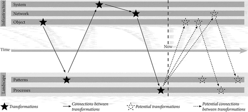
In Infrascape we use coevolution to couple our notion of nested infrastructure with our notion of landscape. Coevolution is the combination of the transformations in landscape and infrastructure and the oftentimes causal connections between these transformations. Coevolution links infrastructure and landscape as equally important entities in infrastructure landscapes.
schematically represents the Infrascape framework. Note that although infrastructure is depicted above landscape they are considered equally important. Both infrastructure and landscape transform over time (stars in ). Transformation in a landscape may introduce a change in the infrastructure, and the other way around (arrows in ). The Infrascape framework can also help to explore coevolutions of infrastructure and landscape that may take place in the future. The Infrascape framework then connects potential transformations of infrastructure and landscape and describes how they might be connected (dotted stars and lines in ). The distinctions between the infrastructure levels (object, network, system) and landscape patterns and processes informs the research approach. To investigate the analytical possibilities of Infrascape, two explorative questions need to be answered. First, can we study transformations of infrastructure in terms of object, network, and system, and landscape transformations in terms of pattern and processes? Second, can we identify connections between these transformations and thus speak of coevolution of infrastructure and landscape? To explore the Infrascape framework we studied the Danube river landscape near Vienna, Austria.
Figure 1. Conceptual framework Infrascape
3. The Danube river landscape as an Infrascape
3.1. Case selection and methods
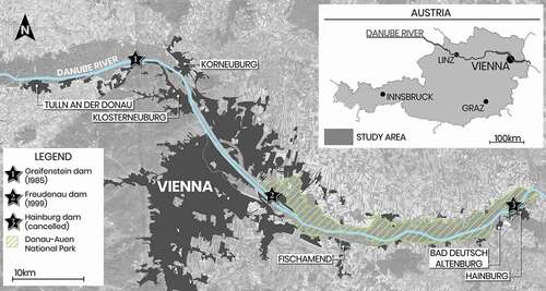
In a case study (Swaffield, Citation2017) we analysed the transformations of infrastructure and landscape over time and identified connections between these transformations in a document analysis. We chose an 80-kilometre-long stretch of the Danube river landscape near Vienna, Austria extending from Tulln an der Donau, upstream of Vienna, to Bad Deutsch Altenburg, downstream of Vienna near the Slovakian border. We focused our analyses and observations on the immediate environment of the river, a zone approximately 3 kilometres wide.
The Danube near Vienna is a large river that has contributed to the formation and transformation of different landscapes around the city of Vienna (). The area contains a diversity of landscapes, varying from highly urbanised city districts to nature reserves. The Danube has been affected by major infrastructural interventions, most prominently the construction of multiple hydropower dams. These characteristics make the Danube river landscape near Vienna a suitable case for examining whether and how infrastructure and landscape have coevolved during the 20th and 21st centuries, using the Infrascape framework.
Figure 2. Map showing the stretch of the Danube that was investigated in the case study, with the hydropower dams and major landscape elements
3.1.1. Landscape analysis
To answer our first explorative question—can we study the transformations of infrastructure in terms of object, network, system and landscape in terms of pattern and processes?—we did a landscape analysis based on map analyses and landscape observations, inspired by Stahlschmidt et al. (Citation2017).
We overlayed contemporary maps (Kuitert, Citation2013) in QGIS to identify the connections between topographic, geomorphological, hydrological and land use patterns. Literature was used to understand the connections between the detected patterns. Grey literature, such as publications by regional heritage organisations, was used to locate transitions between different landscapes and understand small-scale variations in land form and land use. Academic literature helped us understand the large-scale geological and geomorphological processes behind the observed patterns.
To see if and how landscape patterns transformed over time, we compared multiple historical maps in a manner similar to the analysis conducted by Hohensinner et al. (Citation2013). The main difference was that our analysis was purely visual and did not require the digitisation of landscape patterns. We used three maps (1773–1781, 1912, 2020) to analyse transformations following river regulation (1773–1781 vs 1912) and transformations following river damming (1912 vs 2020). To interpret the changes we observed between the maps, we consulted literature on Vienna’s historical development.
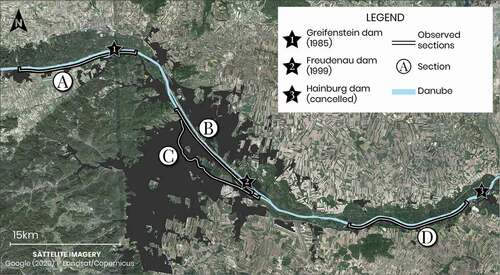
For the landscape observations, the first author visited the study area during a 4-week stay hosted by the University of Natural Resources and Life Sciences in Vienna in January 2019. Data were collected on variables pertaining to river morphology, shoreline morphology, and land use on four sections along the river (see ). These four sections were chosen to include both dammed and non-dammed sections as well as different types of land use (agricultural, urban, industrial, and natural areas). The observations were taken on the roads closest to the river and were only taken on the southern bank of the Danube, which was more easily accessible than the northern bank. Data were collected at about 220 points per section (858 points in total) (see ). Variables were either binary (e.g., the presence of docks) or nominal (e.g., type of shoreline). Data were plotted on maps of the study area for visual inspection of landscape patterns along the river banks and to compare these patterns with those observed in the map analyses.
Figure 3. The studied stretches along the Danube
3.1.2. Document analysis
To answer our second explorative question—can we identify connections between these transformations and thus speak of coevolution of infrastructure and landscape?—we analysed documents on the planning and construction of the hydropower dams to identify connections between the transformations of infrastructure and landscape. We used various reports, books, information brochures, and opinion pieces on the construction of the hydropower dams in the second half of the 20th century. Many of these documents are available in the Infothek of the Donau-Auen National Park (see Appendix A). We also searched international libraries using WorldCat to find documents in German and documents that were not digitally available. The search terms used were ‘Danube’ and ‘hydropower dams’ and their German equivalents ‘Donau’ and ‘Kraftwerke’.
We selected documents that contained information on the coevolution of landscape and infrastructure in the Danube river landscape near Vienna and extracted fragments of text that described transformations of infrastructure and/or landscape. For each fragment, we described whether the infrastructure was regarded as an object, network, or system and whether landscape was described in terms of patterns or processes. We have included three examples of analysed text fragments in Appendix B. We used all text fragments for our description of the Infrascape (section 3.3).
3.1.3. Synthesis
We synthesised the outcomes of the landscape and document analysis, by projecting those outcomes onto , and thereby building a case-specific Infrascape timeline. The landscape analysis, informs on the landscape patterns and processes, as well as the transformation of landscape and infrastructure. The document analysis provides insight into the infrastructural objects, networks, and systems. Lastly, the document analysis enables to establish coevolutions between the landscape patterns and process with the infrastructural objects, networks, and systems.
3.2. Results: transformations of the Danube river landscape
Though the Danube river landscape near Vienna has been transformed multiple times over the centuries, the regulation efforts of the 19th century had the most profound hydrological impact (Hohensinner & Schmid, Citation2013). The regulation was intended to reduce flood risk and improve river navigability by reducing siltation (Hohensinner & Schmid, Citation2013).
To regulate the Danube, side channels were dammed off and the main riverbed was straightened. This transformed the pattern of the Danube from braided, to a narrower, faster-flowing single channel pattern which increased the navigation depth. The faster flow rates increased erosion of the riverbed, and started the process of river incision, further disconnecting the Danube from the floodplains and the side-channels. The incision process also lowered groundwater tables in the floodplains (Habersack et al., Citation2013), which altered patterns such as floodplain ecology, dehydrated Vienna’s Prater park and exposed wooden foundations to air, resulting in rot and degradation.
The 19th-century Danube regulation was formative for the construction of a network of hydropower dams between the 1960s and 1990s. Firstly, the elimination of side-channels made damming easier. Secondly, the dams were expected to reduce river flow and thereby halt the process of river incision and associated problems. Other major arguments in favour of the hydropower dams were that they would meet domestic energy demands, further reduce flood risk, upgrade Vienna’s river boulevard, and improve river navigability. The improvement of river navigability was considered especially important because the planned Rhine-Main-Danube canal—completed in 1992—was expected to transform the Danube system by boosting trans-European shipping, bringing new trade to Vienna.
Guiding the planning of hydropower dams (infrastructural objects) was the Stufenplan (German for level-plan), which was aimed at maximising the power production of the network of dams by minimising free-flowing river sections. This meant that the hydropower dams, with their respective reservoirs, were planned back-to-back as much as possible. In the vicinity of Vienna, three hydropower dams were planned: Greifenstein, Hainburg, and Freudenau. The Greifenstein dam was built first and completed in 1985. Construction on the Hainburg dam, downstream of Vienna, was halted and cancelled due to protests generated by growing environmental awareness and the expected negative ecological impact of the dam. To preserve the ecological processes of the free-flowing river landscape, the area was declared a National Park in 1992. The Freudenau dam, planned in the city of Vienna, was also topic of public debate, but was constructed in 1998 after a referendum.
The existing landscape had major consequences for the design of the infrastructural objects (i.e., the dams). Because the Danube river landscape around Vienna is located on the middle course of the Danube, there is a low river gradient and the landscape is a flat floodplain. It was not feasible to construct a traditional storage dam (Speicherkraftwerk in German) that dams off a gorge or canyon to store large amounts of water for continuous power production. Instead, the Danube hydropower plants were constructed as run-of-the-river dams (Laufkraftwerke in German), which use limited or sometimes no reservoirs (usually called pondages) and are thus more dependent on variations of river flow rate. Because the flat floodplain featured no natural height differences that could be used to form the reservoir, the reservoirs of the Danube dams had to be man-made by constructing reservoir levies on the shorelines of the Danube. These reservoir levies could not always be constructed on land. For example, at Tulln an der Donau the reservoir levies were constructed in the riverbed to preserve landscape patterns such as historic buildings on the shoreline.
The flat floodplain landscape pattern also made it possible to construct the dams on land, after which the river was rerouted through the dam and the old riverbed was dammed off. In contrast, for building a storage hydropower dam, the space in a gorge or canyon is often limited, meaning that the dam often needed to be constructed in the riverbed. Even though the Freudenau dam is also located on a wide river plain, the dam still needed to be constructed in the riverbed because patterns of urban development limited construction space.
The dams had major effects on various landscape patterns and processes. The Greifenstein dam increased the water levels at Tulln an der Donau, which meant the railway bridges across the Danube needed to be heightened. The reservoir levies of the Greifenstein dam straightened the shoreline pattern, which enabled the process of reclaiming major sections of floodplain for settlement. Also, ecological landscape processes were affected by dam construction. Though the dams had positive ecological effects by helping to halt the process of river incision and groundwater subsidence, the dams also negatively affected river ecology by blocking sediment and fish migration processes and preventing floodplain flooding.
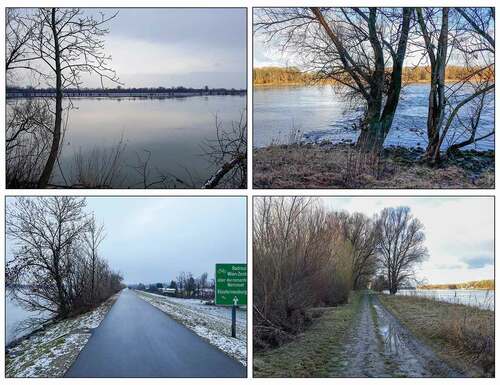
The cancellation of the dam at Hainburg continues to affect the landscape. Because there is no dam to limit flow, the process of river incision is ongoing in the Donau-Auen National Park. Groundwater tables therefore continue to subside, which threatens the ecology of the park. The cancelled dam helps to clarify the difference in patterns of landscape experience that are created by the hydropower dams (). In the Donau-Auen National Park the river is highly dynamic and turbulent (right side ), which creates landscape patterns such as sand and gravel banks in the riverbed and natural shorelines. Patterns that show regular flooding, include tree trunks deposited by the river and sediments on paths and roads. In comparison, the dammed Danube sections (left side of ), are a series of relatively static reservoirs with little turbulence and limited water level fluctuations. The river features no sand or gravel banks and the shorelines are man-made, usually consisting of stone or grassy slopes. Shorelines are generally accessible, as the reservoir levies are elevated and free from flooding.
Figure 4. Pictures taken on dammed (left) and undammed (right) sections of the Danube river landscape. The pictures on the left show visible differences in landscape experience created by the damming of the Danube, such as a less turbulent river, better accessibility of the shorelines and fewer traces of flooding than in the dammed sections
After the completion of the hydropower dams, infrastructural interventions on the Danube near Vienna shifted towards maintenance and improvements. Recently, fish passages have been added to the Greifenstein and Freudenau dams to reenable fish migration processes. To counter the ongoing river incision in the national park, sand nourishments are used to maintain river navigability and prevent ecological degradation. Meanwhile, the subsiding groundwater table and the reduced river dynamics still affect ecological patterns and processes in the National Park, as forests are not rejuvenated and the floodplains are dehydrating (Schöpfer, Citation2017).
3.3. The Danube river landscape as an Infrascape
The use of the Infrascape framework showed multiple examples of coevolution of infrastructure and landscape in the Danube river landscape near Vienna. represents the conceptual framework of Infrascape applied to the case of the Danube river landscape. It depicts a timeline with the major transformations in the infrastructural objects, network, and system, and landscape patterns and processes. The coloured lines show cases of coevolution of infrastructure and landscape.
Figure 5. The coevolution of infrastructure and landscape along the Danube river near Vienna. The different colours represent different instances of coevolution discussed
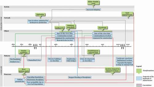
Multiple instances of coevolution can be distinguished. We found that topographical patterns of the landscape are connected to the design and construction method of the individual hydropower dams. The flat topography of the Danube river landscape led to a particular type of dam (green line). An example of how landscape coevolved with infrastructure are the reservoir levies of the Greifenstein dam, which have halted the landscape process of flooding (blue line).
We also found multiple occasions where one coevolution of infrastructure and landscape led to another coevolution. For example, the landscape pattern of historic buildings determined the position of the reservoir levies of the Greifenstein dam (pink line). Subsequently, the Greifenstein dam led to a rise in the Danube’s water level, making it necessary to adapt landscape patterns, such as raising the height of the railway bridges at Tulln an der Donau (purple line). Another example is that the network of dams blocked fish migration, which later formed a reason to construct multiple fish passages along the dams.
We found that the connections between infrastructure and landscape changed in coevolution. This is illustrated by the red line (). It represents how the landscape process of river incision, generated by river regulation, initially led to sinking groundwater tables. This motivated the construction of hydropower dams (objects) to slow river flow and reduce further incision. The cancellation of the Hainburg dam prevented this transformation of the landscape in the Donau-Auen National Park. Here, the ongoing river incision and dehydration of the floodplains damaged ecological processes, but also necessitated sand nourishments to counter the degradation of the riverbed and maintain navigability for shipping (network). This example demonstrates how the coevolution of infrastructure and landscape can differ between infrastructure (as object, network, and system) and landscape (patterns and processes). Overall, as shows, we found more instances of coevolution between the infrastructural object and the landscape than between the infrastructural network or system and the landscape. This may be due to the documents we used, which mainly pertained to the individual hydropower dams.
The case shows that landscape patterns and processes are closely related (Bell, Citation2012) but can create different coevolutions with infrastructure. For example, the landscape process of river incision originated in a change in a landscape pattern produced by river regulation. However, while the landscape pattern of a regulated Danube directly simplified the physical constructions needed for damming, the landscape process of river incision did not have such a direct physical connection to the damming. Instead, the physical problems caused by river incision over time, such as floodplain dehydration, affected the infrastructure because they formed strong arguments for the construction of the hydropower dams.
Similarly, the nested levels of infrastructure (object, network, system) showed different coevolutions of infrastructure and landscape. For instance, the object level of the hydropower dams enabled us to explain many instances of direct spatial-physical coevolution with the landscape, such as the heightening of bridges or the elimination of floodplain flooding. However, without the network level, such as represented by the Stufenplan, it is impossible to understand why each dam ended up at its specific location in the landscape.
Lastly, our case study demonstrated that certain coevolutions of infrastructure and landscape are overlooked by our application of the Infrascape framework, such as the socio-political coevolution of infrastructure and landscape. The cancellation of the Hainburg dam and the establishment of the National Park are good examples of how infrastructure and landscape in the Danube river landscape have also been subjected to non-spatial decisions and interventions by human actors. This coevolution of infrastructure and landscape was not accounted for by our spatial-physical framework.
4. Discussion and conclusions
We identified three key notions for a conceptual framework that can explain the relationship between infrastructure and landscapes as spatial-physical entities. The first is the nested notion of infrastructure objects, within networks, within systems. The second notion is a perspective on landscape as a combination of patterns and processes. The third notion is coevolution, in which we understand infrastructure and landscape as interwoven entities that transform over time. We showed how the Infrascape framework facilitates the empirical study of infrastructure landscapes by revealing many instances of coevolution between infrastructure and landscape.
The coevolutionary perspective in the Infrascape framework, leads to a more comprehensive understanding of infrastructure and landscape compared to the studies of landscape through the lens of infrastructure, or vice versa. These studies include perspectives such as splintering urbanism (Graham & Marvin, Citation2001) where it is the infrastructure that splinters and segregates the socio-economic landscape. Similarly, Carse (Citation2012) considers infrastructure a ‘useful theoretical tool’ (p. 539) through which to study the landscape. Instead, coevolution places the focus on the idiosyncratic combination of infrastructure and landscape. In the Danube river, the particularities in both the landscape (geomorphology, floodplain ecology) and the infrastructure (positions and types of dams) generated a specific relationship that (trans)formed both the landscape and the infrastructure. With knowledge of this specific relationship, engineers and designers can better anticipate the consequences both infrastructural and landscape interventions may have on river incision or floodplain degradation.
This use of coevolution also remains closer to the original ecological definition of ‘reciprocal evolutionary change in interacting species’ (Thompson, Citation1982, p. 3), whereas others use coevolution to describe an independent transformation of infrastructure and landscape imposed by a third factor, e.g., society in Hohensinner et al. (Citation2013). As such, coevolution makes the hybrid character of infrastructure landscapes, described by Buoro (Citation2019) and Lokman (Citation2017), applicable in research. Our case study demonstrated this, since coevolution enabled us to study how the Danube river landscape and its infrastructure became interwoven. The question remains whether coevolution will also help to design and engineer better interventions, e.g., more adaptive (Lokman, Citation2017) or better balanced (Tempels & Hartmann, Citation2014), for infrastructure landscapes. This requires more research by applying the Infrascape framework in design processes.
Such research is also needed to assess whether the Infrascape framework can help determine which choices to make in case of renewal. A first step would be to develop a typology of coevolutions in infrastructure landscapes. Such a typology can provide insight into how unique infrastructure landscapes develop from specific coevolutions of infrastructure (objects, networks and systems) and landscape (patterns and processes). This insight is needed to move from the knowledge gained in a particular case study to more widely applicable guidelines for the management and design of infrastructure landscapes. This way, the Infrascape framework represents an analytical contribution to inspiring design philosophies such as Landscape Infrastructure (Belanger, Citation2016; Nijhuis & Jauslin, Citation2015). This can potentially result in more empirically substantiated design solutions for infrastructure landscapes than those relying on ‘accidental’, non-structural, observations by designers.
The spatial-physical focus of the Infrascape framework adds to existing sociological, socio-political, or anthropological perspectives on infrastructure landscapes (e.g., Edwards, Citation2003; Gandy, Citation2011; Larkin, Citation2013), which generally emphasise the role of human agents (e.g., institutions, communities, agencies). Studying the spatial-physical aspects of infrastructure landscapes, clarifies how physical infrastructure and landscape too can become agents of transformation. For example, in our case the anthropogenic transformation of the Danube has initiated autonomous transformations of the landscape that carry unintended consequences for the region. Further research is needed to investigate how these insights, combined with socio-political perspectives, can contribute to understanding and developing inclusive and sustainable infrastructure landscapes. Overall, our case study showed that neither a solely spatial-physical, nor social perspective does justice to the complexity of infrastructure landscapes.
The coevolutionary approach of the Infrascape framework enables a better understanding of the complex and close relationship between infrastructure and landscape. Applying the Infrascape framework to empirical cases, such as the Danube river landscape near Vienna, reveals many coevolutions between infrastructure and landscape. Studying such coevolutions is essential for developing renewal strategies that produce future-proof Infrascapes.
Geolocation information
Our case study was conducted in the Danube river landscape near Vienna, Austria. Our study area ranged from Tülln an der Donau (48.33393,16.05959) to Bad-Deutsch Altenburg (48.14217,16.90240).
Disclosure statement
No potential conflict of interest was reported by the authors.
Additional information
Funding
Notes on contributors
Laszlo van der Wal
Laszlo van der Wal is a PhD student in Landscape Architecture studying the renewal of hydraulic infrastructure in major rivers as a landscape design challenge.
Mark Zandvoort
Mark Zandvoort researches water management and infrastructure planning at Wageningen University & Research and is an advisor at TAUW B.V. on water and infrastructure. His research focuses on the challenges of uncertainty for the adaptive planning of landscapes and infrastructure.
Hilde Tobi
Hilde Tobi is an experienced research methodologist with experience ranging from social and medical to environmental sciences. She studies the methodology needed for interdisciplinary research, including research ethics and integrity.
Maarten van der Vlist
Maarten van der Vlist is a principle advisor at Rijkswaterstaat with an expertise in adaptive water management and extraordinary associate professor at Wageningen University on adaptive delta management. His work includes the Next Generation Infrastructure 2.0 initiative, assessing the value of infrastructures for society.
Adri van den Brink
Adri van den Brink is professor emeritus of Landscape Architecture at Wageningen University and visiting professor at the Czech University of Life Sciences Prague, Faculty of Environmental Sciences. He has an extensive academic record in land use planning and landscape architecture. He has made major contributions in the methodological development of landscape architecture research.
References
- Allen, S. (1999). Infrastructural Urbanism. In Points+Lines: Diagrams and projects for the city (pp. 46–59). Princeton Architectural Press.
- Antrop, M., & Van Eetvelde, V. (2017). Landscape perspectives. In Landscape Series (Vols. 23, Issue 23). Springer Netherlands. https://doi.org/https://doi.org/10.1007/978-94-024-1183-6
- Arts, B., Buizer, M., Horlings, L., Ingram, V., Van Oosten, C., & Opdam, P. (2017). Landscape approaches: A state-of-the-art review. Annual Review of Environment and Resources, 42(1), 439–463. https://doi.org/https://doi.org/10.1146/annurev-environ-102016-060932
- Batty, M. (2013). The new science of cities. MIT Press.
- Belanger, P. (2016). Landscape as infrastructure: A base primer. Routledge.
- Bell, S. (2012). Landscape: Pattern, perception and process (2nd ed.). Routledge.
- Brown, H. (2013). Next generation infrastructure: Principles for post-industrial public works. Washington, DC: Island Press. https://doi.org/https://doi.org/10.5822/978-1-61091-202-0
- Brykała, D., & Podgórski, Z. (2020). Evolution of landscapes influenced by watermills, based on examples from Northern Poland. Landscape and Urban Planning, 198(January), 87–100. https://doi.org/https://doi.org/10.1016/j.landurbplan.2020.103798
- Buoro, M. (2019). Landscape-infrastructure: Shifts of meaning for changing cities. Ri-Vista, 17(1), 186–197. https://doi.org/https://doi.org/10.13128/rv-7021
- Carse, A. (2012). Nature as infrastructure: Making and managing the Panama Canal watershed. Social Studies of Science, 42(4), 539–563. https://doi.org/https://doi.org/10.1177/0306312712440166
- Castán Broto, V., & Sudhira, H. S. (2019). Engineering modernity: Water, electricity and the infrastructure landscapes of Bangalore, India. Urban Studies, 56(11), 2261–2279. https://doi.org/https://doi.org/10.1177/0042098018815600
- Chappin, E. J. L., & van der Lei, T. (2014). Adaptation of interconnected infrastructures to climate change: Asocio-technical systems perspective. Utilities Policy, 31, 10–17. https://doi.org/https://doi.org/10.1016/j.jup.2014.07.003
- Coutard, O., & Rutherford, J. (2015). Beyond the networked city infrastructure reconfigurations and urban change in the North and South. Routledge.
- De Block, G. (2014). Planning rural-urban landscapes: Railways and countryside urbanisation in South-West Flanders, Belgium (1830–1930). Landscape Research, 39(5), 542–565. https://doi.org/https://doi.org/10.1080/01426397.2012.759917
- Deltacomissaris. (2013). Deltaprogramma 2013 - Werk aan de delta: De weg naar deltabeslissingen. Ministerie van Infrastructuur en Milieu.
- Doyle, M. W., & Havlick, D. G. (2009). Infrastructure and the environment. Annual Review of Environment and Resources, 34(1), 349–373. https://doi.org/https://doi.org/10.1146/annurev.environ.022108.180216
- Edwards, P. N. (2003). Infrastructure and Modernity: Force, Time, and Social Organization in the History of Sociotechnical Systems. Published in Philip Brey, Arie Rip, and Andrew Feenberg, Eds., Technology and Modernity: The Empirical Turn (Forthcoming 2002) (pp. 185–226). Cambridge, MA, USA: The MIT Press. http://citeseerx.ist.psu.edu/viewdoc/summary?doi=10.1.1.97.2776
- Frangopol, D. M. (2011). Life-cycle performance, management, and optimisation of structural systems under uncertainty: Accomplishments and challenges. Structure and Infrastructure Engineering, 7(6), 389–413. https://doi.org/https://doi.org/10.1080/15732471003594427
- Fujihara, M., & Kikuchi, T. (2005). Changes in the landscape structure of the Nagara River Basin, central Japan. Landscape and Urban Planning, 70( 3–4 SPEC. ISSuppl.), 271–281. https://doi.org/https://doi.org/10.1016/j.landurbplan.2003.10.027
- Gandy, M. (2011). Landscape and infrastructure in the late-modern metropolis. In G. Bridge & S. Watson (Eds.), The new Blackwell companion to the city (pp. 57–65). Wiley-Blackwell. https://doi.org/https://doi.org/10.1002/9781444395105
- Grafius, D. R., Varga, L., & Jude, S. (2020). Infrastructure interdependencies: Opportunities from complexity. Journal of Infrastructure Systems, 26(4), 04020036. https://doi.org/https://doi.org/10.1061/(asce)is.1943-555x.0000575
- Graham, S., & Marvin, S. (2001). Splintering urbanism: Networked infrastructures, technological mobilities, and the urban condition. Routledge.
- Habersack, H., Jäger, E., & Hauer, C. (2013). The status of the Danube River sediment regime and morphology as a basis for future basin management. International Journal of River Basin Management, 11(2), 153–166. https://doi.org/https://doi.org/10.1080/15715124.2013.815191
- Hauer, F., Hohensinner, S., & Spitzbart-Glasl, C. (2016). How water and its use shaped the spatial development of Vienna. Water History, 8(3), 301–328. https://doi.org/https://doi.org/10.1007/s12685-016-0169-7
- Hertogh, M. J. C. M., Bakker, J. D., van der Vlist, M. J., & Barneveld, A. S. (2018). Life cycle management in upgrade and renewal of civil infrastructures. Organization, Technology and Management in Construction: An International Journal, 10(1), 1735–1746. https://doi.org/https://doi.org/10.2478/otmcj-2018-0005
- Ho, M., Lall, U., Allaire, M., Devineni, N., Kwon, H. H., Pal, I., Raff, D., & Wegner, D. (2017). The future role of dams in the United States of America. Water Resources Research, 53(2), 982–998. https://doi.org/https://doi.org/10.1002/2016WR019905
- Hoeksema, R. J. (2007). Three stages in the history of land reclamation in the Netherlands. Irrigation and Drainage, 56(1), 113–126. https://doi.org/https://doi.org/10.1002/ird
- Hohensinner, S., Lager, B., Sonnlechner, C., Haidvogl, G., Gierlinger, S., Schmid, M., Krausmann, F., & Winiwarter, V. (2013). Changes in water and land: The reconstructed Viennese riverscape from 1500 to the present. Water History, 5(2), 145–172. https://doi.org/https://doi.org/10.1007/s12685-013-0074-2
- Hohensinner, S., & Schmid, M. (2013). The more dikes the higher the floods: Vienna and its Danube floods, ca. 1700 to 1918. “Disasters Wet and Dry: Rivers, Floods, and Droughts in World History“, Beijing, Renmin University of China, May 23-26, 2013 (pp. 1–23).
- Jacobs, M. (2006). The production of mindscapes: a comprehensive theory of landscape experience. Wageningen University.
- Kirchherr, J., Pohlner, H., & Charles, K. J. (2016). Cleaning up the big muddy: A meta-synthesis of the research on the social impact of dams. Environmental Impact Assessment Review, 60, 115–125. https://doi.org/https://doi.org/10.1016/j.eiar.2016.02.007
- Kuitert, W. (2013). Urban landscape systems understood by geo-history map overlay. Journal of Landscape Architecture, 8(1), 54–63. https://doi.org/https://doi.org/10.1080/18626033.2013.798929
- Larkin, B. (2013). The Politics and Poetics of Infrastructure. Annual Review of Anthropology, 42(1), 327–343. https://doi.org/https://doi.org/10.1146/annurev-anthro-092412-155522
- Li, X., He, H. S., Xiu, C., Li, B., & Shendrik, A. (2020). Twenty years of post-soviet union urban land use change of St. Petersburg. Applied Spatial Analysis and Policy, 13(4), 1019–1033. https://doi.org/https://doi.org/10.1007/s12061-020-09340-9
- Linton, J., & Budds, J. (2014). The hydrosocial cycle: Defining and mobilizing a relational-dialectical approach to water. Geoforum, 57, 170–180. https://doi.org/https://doi.org/10.1016/j.geoforum.2013.10.008
- Lokman, K. (2017). Cyborg landscapes: Choreographing resilient interactions between infrastructure, ecology, and society. Journal of Landscape Architecture, 12(1), 60–73. https://doi.org/https://doi.org/10.1080/18626033.2017.1301289
- Nijhuis, S., & Jauslin, D. (2015). Urban landscape infrastructures Designing operative landscape structures for the built environment. Research In Urbanism Series, 3(1), 13–34. https://doi.org/https://doi.org/10.7480/rius.3.874
- Noble, P. (2019). Growth in the shipping industry: Future projections and impacts. In International Ocean Institute- Canada (Eds.), The future of ocean governance and capacity development, (pp. 456–461). Brill | Nijhoff, Leiden, The Netherlands. https://doi.org/https://doi.org/10.1163/9789004380271_079
- Pingram, M., Price, J., & Thoms, M. (2019). Integrating multiple aquatic values: Perspectives and a collaborative future for river science. River Research and Applications, 35(10), 1607–1614. https://doi.org/https://doi.org/10.1002/rra.3562
- Rinaldi, S. M. (2004). Modeling and simulating critical infrastructures and their interdependencies. Proceedings of the Hawaii International Conference on System Sciences, 37, 873–880. https://doi.org/https://doi.org/10.1109/hicss.2004.1265180
- Schmutz, S., & Moog, O. (2018). Dams: Ecological impacts and management. In S. Schmutz & J. Sendzimir (Eds.), Riverine ecosystem management- Science for governing towards a sustainable future (pp. 111–128). Springer International Publishing. https://doi.org/https://doi.org/10.1007/978-3-319-73250-3
- Schöpfer, A. (2017). Capturing the effects of the Danube River incision on the potential natural vegetation of the Donau - Auen National Park. 6th International Symposium for Research in Protected Areas 2017, University of Salzburg.
- Schröder, B. (2006). Pattern, process, and function in landscape ecology and catchment hydrology - How can quantitative landscape ecology support predictions in ungauged basins? Hydrology and Earth System Sciences, 10(6), 967–979. https://doi.org/https://doi.org/10.5194/hess-10-967-2006
- Stahlschmidt, P., Swaffield, S., Primdahl, J., & Nellemann, V. (2017). Landscape analysis – Investigating the potentials of space and place. Routledge.
- Strang, G. L. (1996). Infrastructure as Landscape. Places, 10(3), 9–15. https://escholarship.org/uc/item/6nc8k21m
- Swaffield, S. (2017). Case studies. In A. van den Brink, D. Bruns, H. Tobi, & S. Bell (Eds.), Research in landscape architecture (pp. 105-119). Routledge.
- Tempels, B., & Hartmann, T. (2014). A co-evolving frontier between land and water: Dilemmas of flexibility versus robustness in flood risk management. Water International, 39(6), 872–883. https://doi.org/https://doi.org/10.1080/02508060.2014.958797
- Thayer, R. L. (1992). Three dimensions of technology in the american landscape. Landscape Journal, 11(1), 66–79. https://doi.org/https://doi.org/10.3368/lj.11.1.66
- Thompson, J. N. (1982). Interaction and coevolution. The University of Chicago Press.
- Tobi, H., & van den Brink, A. (2016). A process approach to research in landscape architecture. In A. van den brink, D. Bruns, H. Tobi, & S. Bell (Eds.), Research in landscape architecture - Methods and methodology (pp. 24–34). Routledge. https://doi.org/https://doi.org/10.4324/9781315396903
- Turner, M. G., & Gardner, R. H. (Eds.). (1991). Quantitative methods in landscape ecology (Vol. 82). Springer. https://doi.org/https://doi.org/10.1007/978-1-4757-4244-2
- van der Vleuten, E., & Disco, C. (2004). Water wizards: Reshaping wet nature and society. History and Technology, 20(3), 291–309. https://doi.org/https://doi.org/10.1080/0734151042000287014
- van der Vlist, M. J., Ligthart, S. S. H., & Zandvoort, M. (2015). The replacement of hydraulic structures in light of tipping points. Journal of Water and Climate Change, 6(4), 683–694. https://doi.org/https://doi.org/10.2166/wcc.2015.094
- van Heezik, A. (2007). Strijd om de rivieren: 200 jaar rivierenbeleid in Nederland of de opkomst en ondergang van het streven naar de normale rivier. Technische Universiteit Delft.
- Whipple, K. X. (2002). Implications of sediment-flux-dependent river incision models for landscape evolution. Journal of Geophysical Research, 107(B2), ETG 3-1 - ETG 3-20. https://doi.org/https://doi.org/10.1029/2000jb000044
- Wu, C. F., Lin, Y. P., Chiang, L. C., & Huang, T. (2014). Assessing highway’s impacts on landscape patterns and ecosystem services: A case study in Puli Township, Taiwan. Landscape and Urban Planning, 128, 60–71. https://doi.org/https://doi.org/10.1016/j.landurbplan.2014.04.020
- Zandvoort, M., & van der Vlist, M. J. (2020). Planning infrastructure replacements: Restructuring and exerting partial control over the environment. Environmental Science & Policy, 103(October2019), 67–76. https://doi.org/https://doi.org/10.1016/j.envsci.2019.10.010