381
Views
0
CrossRef citations to date
0
Altmetric
Corrigendum

Corrigendum

This article refers to:
Landsat-based wheat mapping in the heterogeneous cropping system of Punjab, Pakistan

Khan, A., Hansen, M.C., Potapov, P., Stehman, S.V., and Chatta, A.A. 2016. “Landsat-based wheat mapping in the heterogeneous cropping system of Punjab, Pakistan.” International Journal of Remote Sensing 37 (5–6): 1391–1410. http://dx.doi.org/10.1080/01431161.2016.1151572

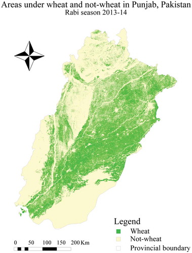
The authors of the above article advise that there is an error in the legend of . The correct figure is reproduced below.

Figure 3. Rabi season 2013–2014 wheat classification map for Punjab, Pakistan.

Figure 3. Rabi season 2013–2014 wheat classification map for Punjab, Pakistan.

Reprints and Corporate Permissions

Please note: Selecting permissions does not provide access to the full text of the article, please see our help page How do I view content?

To request a reprint or corporate permissions for this article, please click on the relevant link below:

Academic Permissions

Please note: Selecting permissions does not provide access to the full text of the article, please see our help page How do I view content?

Obtain permissions instantly via Rightslink by clicking on the button below:

If you are unable to obtain permissions via Rightslink, please complete and submit this Permissions form. For more information, please visit our Permissions help page.