

ABSTRACT
Over last decade, hundreds of deep learning algorithms using CNN, ViT, MLP, and deep LSTM are proposed to classify hyperspectral remote sensing images with accuracy reaching to almost 100% with testing samples. Due to the availability of limited training/test data for remote sensing classifications, achieving very high accuracy may lead to the problem of selecting a suitable deep classifier. In this study, we provide a review of these algorithms in terms of classified image, training sample size as well as patch size. We then compare the results of twelve existing deep learning algorithms with three hyperspectral datasets in terms of classification accuracy, quality of classified image as well as the area under each land cover class. Results from this study suggest that in spite of achieving high classification accuracy, a comparison of classified image as well as the area under different classes indicates no clear-cut winner. Variation in classifying unlabelled area to different classes as well as in area calculation creates doubt about the suitability of different algorithms, which can be used for accurate mapping of large areas for various applications including deforestation and agricultural studies.
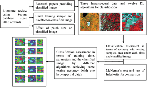
GRAPHICAL ABSTRACT
Acknowledgements
Help of my undergraduate students Akshay Poria and Ajay Nain for implementing different DL algorithms is acknowledged. AVIRIS-NG hyperspectral data was provided by Space Application center (ISRO) under the research project, which cannot be made available to other researchers. DAIS data can be made available on request. Constructive comments of the reviewers also helped in improving this manuscript.
Disclosure statement
No potential conflict of interest was reported by the author(s).