?Mathematical formulae have been encoded as MathML and are displayed in this HTML version using MathJax in order to improve their display. Uncheck the box to turn MathJax off. This feature requires Javascript. Click on a formula to zoom.
This article refers to:
Article title: Assessing the spatial resolution distance of satellite images: SuperDove versus Landsat 8
Authors: Valenzuela, A., K. Reinke, and S. Jones
Journal: International Journal of Remote Sensing
DOI: https://doi.org/10.1080/01431161.2024.2357839
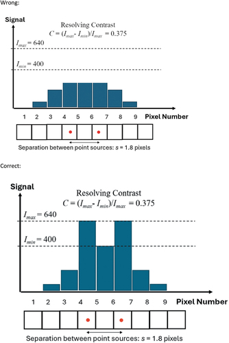
When this article was first published online, there were few errors in the equations and Figure 2these have been corrected and updated as below.
Error #1: K symbol is missing in Equation 3
Wrong:
Correct:
Error #2: f symbol is missing in Equation 4
Wrong:
Correct:
Error #3: Figure 5 was incorrect