
 ?Mathematical formulae have been encoded as MathML and are displayed in this HTML version using MathJax in order to improve their display. Uncheck the box to turn MathJax off. This feature requires Javascript. Click on a formula to zoom.
ABSTRACT
Off-road driving activities are common in many protected areas. This study aimed at applying a curvelet-based approach for the automatic extraction, mapping and separation of off-road tracks and animal paths in Masai Mara National Reserve, Kenya, using high-resolution GeoEye-1 panchromatic satellite imagery (50 cm). A novel hybrid remote sensing-GIS method comprising three main blocks is proposed: (1) extracting the high-contrast curvilinear feature from curvelet magnitudes derived from the finer scale of curvelet coefficient; (2) extracting the low-contrast curvilinear feature from coarser scale curvelets and refine the shape by deformable active contour (Snake), and (3) categorizing the extracted curvilinear feature into vehicle tracks and animal paths by a fuzzy logic inference system. Results from quantification of extraction and categorization performance of the trails were 77.5% for completeness, 89.2% for correctness, and 4.5% for redundancy, with an overall accuracy of 79.5%. Using grid matching, we find a high correlation between off-road vehicle tracks and animal paths in the area (r = 0.75, p < 0.05) indicating co-occurrence of these two types of trails. The proposed approach provides a basis for large-scale mapping and monitoring of off-road tracks and animal paths in the African savanna from space.
1. Introduction
Tour drivers and tourists usually seek to get as close as possible to animals in protected areas (such as national parks and nature reserves) and drive off the designated roads, resulting in off-road trails. The uncontrolled use of all-terrain vehicles impacts the structure and functioning of the ecological system in various ways. The effects manifest in the form of compaction-induced soil degradation (Nortjé, Van Hoven, and Laker Citation2012), impact on plant biodiversity (Hammitt, Cole, and Monz Citation2015; Switalski Citation2018), and disturbance of wildlife habitats – impacting animal intra and inter species associations, dispersal patterns, breeding behaviour, prey-predator relationships and feeding behaviour (Belsoy, Korir, and Yego Citation2012; Jahani, Goshtasb, and Saffariha Citation2020; Ploughe and Fraser Citation2022; van Vierssen Trip and Wiersma Citation2015). However, despite the impacts of off-road driving on the natural environment, efforts to control off-road driving are fragmented and underfunded, and in some cases, illicitly promoted as tour drivers seek to please tourists, whose gate entry revenue helps fund wildlife conservation efforts (Hovius, Hovius, and Criscione-Naylor Citation2023; Nortje Citation2014; Wolf, Croft, and Green Citation2019).
Efforts have been made to examine off-road driving tracks through ground surveys (Walpole Citation2003; Wilson and Seney Citation1994), but these surveys are time-consuming and costly in terms of human resources, especially when numerous off-road tracks span vast areas. Aerial photography offers a better surveying approach, overcoming some of the shortcomings of ground-based surveys such as cost, time and human effort. Digitized off-road vehicle tracks from aerial photography were analysed by Griggs and Walsh (Citation1981) and Priskin (Citation2003) to evaluate the environmental impacts. However, in large areas with high-density trail distribution, the manual labour required for digitization of the tracks is considerable, making this approach time-consuming and tedious (Laptev et al. Citation2000).
Automated cartographic feature extraction from satellite images has a wide range of applications in database development for operational and policy decisions. Road network extraction from high-resolution images is an interesting challenge for both computer vision and remote sensing scientists (Mena Citation2003). However, road extraction from digital images, in many cases, still follows an ‘ad-hoc multistage approach’ (Mnih and Hinton Citation2010). Compared to man-made roads, off-road tracks and animal paths present a more complex challenge in image detection due to the variety of feature widths, the heterogeneous spectral properties and the more complicated background.
Although tarmac, gravel and off-road tracks are both curvilinear features, off-road tracks are situated in the natural environment and have different backgrounds and contexts from main roads for which research on extraction has been focused. Therefore, remodelling the curvilinear feature in complex landscapes such as tropical protected areas and their relations with the background objects is crucial. In addition, and more specifically, in heterogeneous protected areas such as the Masai Mara and Serengeti ecosystems, the extraction is confounded by the mix of designated roads, off-road tracks, and wildlife trails from millions of animals interacting with the ecosystem. However, this is an interesting challenge as it provides an opportunity for extracting the animal paths. Once they are separated from the vehicle tracks, further spatial patterns can be analysed for applications such as understanding wildlife movements, distribution patterns and habitat utilization.
Many segmentation approaches have been proposed and tried for curvilinear feature extraction of remotely sensed data. Among them is the curvelet transform originally developed for describing an object with edges by a minimal number of coefficients in the continuous space (E. Candès and Donoho Citation1999). Much research has been done to process digital images to transfer the definitions from the constant to the discrete space (E. J. Candès and Guo Citation2002; E. Candès et al. Citation2006). In geosciences, it has been used for synthetic aperture radar (SAR) images to reduce speckle noise (Puranikmath and Vani Citation2016). Edge detection from SAR images has also been done after the good performance of curvelet transform to preserve the edge while deducting the speckle noise (Ying et al. Citation2011). Approaches that use a curvelet transform-based approach can also be coupled with other methods such as an active contour model (snake algorithm) to extract features (Jianwei, Antoniadis, and Le Dimet Citation2006). Therefore, there is potential for applying the curvelet transform to derive complex features from remote sensing imagery, such as off-road tracks and animal paths.
We consider that the curvelet transform has potential for this task because of a number of reasons. First, one of the primary strengths of the curvelet transform is in its ability to effectively capture and represent image features with complex structures or textures at various scales and orientations (Fadili and Starck Citation2009; Sinha, Teli, and Sivakumar Citation2021). Secondly, since the curvelet transform provides a sparse representation of images, it allows for an efficient representation and reduced dimensionality from the transform coefficients, which is helpful for denoising and enhancing feature extraction as required for off-road tracks and animal paths in this challenge (Sinha, Teli, and Sivakumar Citation2021). Thirdly, unlike other transformations, curvelets are highly directional, which means they can efficiently capture edge and texture information in different directions within an image. This directional sensitivity is advantageous for extracting linear features where orientation plays a critical role (Geback and Koumoutsakos Citation2009; Jianwei, Antoniadis, and Le Dimet Citation2006). Lastly, curvelets are well-suited for capturing curved structures and contours such as those expected from target off-road trails and animal paths (Chavan et al. Citation2020). In addition, more than just extracting the curvilinear features is required if they cannot be correctly categorized. In that case, fuzzy logic inference, a system of knowledge representation that processes human knowledge in fuzzy rules, is required to solve the ambiguity and vagueness of the classes of the extracted tracks.
This research tested whether integrating the curvelet transform with a fuzzy logic inference system can be effectively applied to extract and separate off-road tracks and animal paths from high-resolution satellite imagery in a complex, heterogeneous environment. Specifically, given the complexity of the trails to be extracted, we first extract the relatively high-contrast curvilinear features by applying the non-maximal suppression algorithm to the finer-scale curvelet coefficients. We then extract the relatively low-contrast curvilinear features by applying the curvelet-based snake algorithm to the coarser scale curvelet coefficients and finally categorize the extracted curvilinear features into animal paths and vehicle trails using fuzzy logic inference system and evaluate their geometric and categorical performance relative to reference data.
2. Materials and methods
2.1. Study area and satellite data
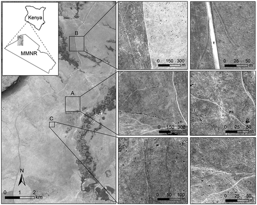
The study area was located in the Maasai Mara National Reserve (MMNR), Kenya (). The area is economically important as it generates income for the country and creates employment for many local people working in the wildlife-based tourism industry. The GeoEye-1 satellite image was acquired on 11 August 2009 and covers the northwestern part of the reserve. The satellite image was geo-referenced to the projection system of UTM Zone-36 South with the geodetic datum of WGS-84. It covers an area of 108 km2. Only the panchromatic band was used because it has the highest spatial resolution of 0.5 m since the curvelet transform works on a single band. Three pilot sites were used, and the off-road tracks and animal paths were extracted. The three sites were purposely selected as areas that had visible off-road tracks and animal paths, identified from a mesh of equal units created at two scales. This was done to ensure that the target being extracted was correctly identified. The size of Site A and Site B was 1 km × 1 km, while Site C was 0.35 km × 0.34 km.
Figure 1. A depiction of the three pilot study sites in the Masai Mara National Reserve (MMNR), Kenya. The insert in column 1 shows the location of the study area, column 2 (top) and column 3 (top) shows a designated road, column 2 (middle) and column 3 (middle) show off-road tracks, and column 2 (bottom) and column 3 (bottom) shows animal paths. Satellite image © 2009 Maxar Technologies.
Mapping off-road tracks and animal paths followed three sequential modules: (i) trail conceptualization and spatial modelling, (ii) image processing and fuzzy inference and (iii) model evaluation.
2.2. Off-road tracks and animal paths conceptualization and detection
We first conceptualized how the digital image can represent off-road tracks and animal paths and what and how unique properties of trails make them distinguishable from other neighbouring objects in a heterogenous environment like the Masai Mara National Reserve. Conceptualization of these properties provides a basis for accurate and efficient extraction of the trails and distinguishing between them. We adapted the definition of the trail characteristic from known properties of surfaced and unsurfaced roads whose properties have been characterized with remote sensing (Abdollahi et al. Citation2020; Jia et al. Citation2021). A road model conceptually comprises explicit information about geometry, radiometry, topology and context relations (Michaelsen and Meidow Citation2019; Senthilnath, Rajeshwari, and Omkar Citation2009). Therefore, different types of trails are expected to appear differently on the GeoEye-1 imagery in our study area. Unique geometry, radiometry, topology, and context relation features can be used to extract and categorize trails at various scales.
The geometry and radiometry level is an intermediate level representing the 2D shape of the object and its materials (Chen et al. Citation2022; Wang et al. Citation2016). At this level, the objects are described independently from sensor characteristics and viewpoints. The finer scale gives more detailed information from which a parallel double thin line can be found; the coarse scale adds global information. Because of the abstraction at a coarse scale, additional information such as width and position can be used to identify the trails from finer scales. In this way, the extraction benefits from both the finer and coarser scales of conceptualization.
We expect the complexity of detecting curvilinear features in remotely sensed images to arise because of some very weak and blurry edges of the off-road tracks and animal paths. As such, the difference between the trails and their surroundings is so small, making them difficult to detect. In addition, the geometric and radiometric characteristics of the different types of trails are different; therefore, more than a single processing procedure is required to complete the task. Furthermore, different kinds of trails have different contrast levels to their surrounding background, which can help in the extraction process but complicate the extraction problem, given the heterogeneous environment in which they exist. These challenges have hindered much of the considerable work done for road extraction in photogrammetry and remote sensing image processing (Liu et al. Citation2022; Wulamu et al. Citation2019).
2.3. Extraction of high- and low-contrast image features using curvelet transform
We apply three sequential curvelet-transform-based image processing steps, starting with the extraction of the relatively high-contrast curvilinear features and the extraction of the relatively low-contrast curvilinear features. Curvelets are a non-adaptive technique for multi-scale object representation and an advancement for wavelets. Wavelet-based methods are known to deal with edge-detection problems with low-contrast images as they have good performance at representing point singularities (Tieling, Jinfei, and Kaizhong Citation2002). Unfortunately, wavelets ignore the geometric properties of objects with edges and do not exploit the regularity of the edge curves in higher dimensions dataset (Li et al. Citation2022). To overcome the disadvantages of wavelets, ridgelets were proposed. Ridgelets extract frequencies of an image in all directions and help represent lines and singularities across using fewer coefficients (sparse representations) (E. Candès Citation1998; Fadili and Starck Citation2009). Although the ridgelets improve on feature detection, most of the natural images contain curves rather than lines for which ridgelets are focused. Although built roads/tracks are generally straight, the off-road tracks and animal paths targeted for extraction in this study are mostly curvilinear rather than straight lines, as they are unplanned. Therefore, a curvelet transform, which better represents curves, is used to depict natural images rather than lines.
2.3.1. Curvelet transform
Curvelets were developed as geometric multiscale transforms to deal with this problem by providing optimal sparse representation of objects with C2-singularities for better representation of curvilinear features rather than lines (E. J. Candès and Guo Citation2002; E. Candès et al. Citation2006). All the applications of the digital curvelet transform in this research pertain to the spatial domain of image processing and do not consider the time domain in signal processing, which was originally proposed by Candès et al. (Citation2006) (Appendix A).
2.3.2. High-contrast feature extraction
After the image enhancement with the curvelets, we extract the high-contrast curvilinear features from the image. The way in which curvelets transform the image from the spatial domain to the curvelet domain is described by Geback and Koumoutsakos (Citation2009). In this research, the dominant direction shows the direction along the curvilinear feature to be extracted. To be able to describe the dominant direction and location of the curvilinear, a series of steps are implemented (Appendix A). The curvilinear features are represented by the larger coefficients in the high frequency band corresponding to the finer scale. We use the non-maximal suppression on finer scale curvelet magnitude along the dominant direction. However, the curvilinear features that are detected are not always connected. Although the short segments of a complete edge have been handled by the thresholding procedure, due to the nearby edges that may influence the local maximum condition of the current edge, it fails to detect the edge completely. By extending the edge along the dominant direction, the gaps between those small segments can thus be bridged. By starting from the end grid of the edge, we mark the grids along the dominant directional fields as edges until it reaches the starting grid of another edge segment, a process similar to growing the edges (Appendix A).
2.3.3. Low-contrast feature extraction
To find the low-contrast curvilinear features, the enhancement of the low-contrast curvilinear features should be done first to make it more detectable. After the low-contrast features are enhanced, the non-maximal suppression algorithm is employed again to extract the high-contrast curvilinear feature. The shape of the low-contrast curvilinear features is rigid due to the scale from which they have been detected. The active contour model (also called the ‘snake’ algorithm) is then applied to refine the shapes by minimizing the energy from the initial contour. The active contour model is a method to fit open or closed splines to lines or edges in an image Kass et al. (Citation1988). A snake is a deformable continuous curve whose shape is controlled by internal forces and external forces from the data (Menet, Saint-Marc, and Medioni Citation1990). Curvelet coefficients can be modified to enhance edges in an image. For the image in this research, a function as defined by Starck (Citation2003) is applied. To not only enhance the curvilinear features of our images but also suppress the background speckle noise, we incorporate hard thresholding into Starck’s function and obtain an improved gain function using coefficients. The coefficients are changed from the second coarsest scale to the finest scale. For each scale and within each direction, we calculate the median value of the curvelet coefficients. Since the noise and the background speckle appear in the finest scale, these are suppressed by a constant value (Appendix A).
Finally, the image is transformed back into the spatial domain by applying the inversed digital curvelet transform. The dark lines are preserved while the background is smoothed and becomes homogenous. The ultimate state of snake evolution has been reached, and the points on the snake become stable since they have reached the energy minimum. The growing procedure starts from the end point of each snake line. For each time, there is only one current point created which is several pixels away from the last point. The determination of each newly grown point depends on the curvelet- based enhanced image. There is a searching window for the pixel with the lowest grey value from the curvelet-based enhanced image. This is done iteratively until the stop condition is reached where there are no more changes in the grey value. After that, smoothing with spline fitting procedure is applied to reconstruct the low-contrast curvilinear feature based on the snake points after growing. The reconstruction mathematical model is a smoothing spline which is a compromise between a linear equation and a third-order spline that minimizes the whole term (Kass et al. (Citation1988) (Appendix A).
2.4. Using fuzzy logic inference system to separate off-road tracks and animal paths
The trails extracted from the previous steps do not contain any categorical information but are just some curvilinear feature segments. Therefore, the next step was to interpret and categorize them by simulating human perception. Fuzzy logic inference system is designed for emulating human reasoning when they are classifying things such as road features and other image objects (Maboudi et al. Citation2018; Rastiveis et al. Citation2020). We apply the fuzzy logic inference concept after Kainz (Citation2002) to develop indicators that are used to assign different membership functions for off-road tracks and animal trails. To get different indicator values for each segment, for each curvilinear feature segment, we sample some of the points on it so that it can maintain both efficiency and statistical representativeness. The basic rules applied for the fuzzy logic inference for the categorization were developed from reference points and are the following:
The designated road appears in the image as a unified wide line. It has an extremely high spectral contrast to its background, and the profile can thus be modelled by piecewise linear equation.
Off-road tracks type 1 appears in the image as double-line track. It has a relatively high spectral contrast to its background. The double peak shape profile can be modelled by a quadratic polynomial equation.
Off-road tracks type 2 appears in the image as a dark line. It has a relatively low spectral contrast to its background. The valley-like profile can be modeled by a parabola.
Animal paths appear in the image as multiple twisted threads. They have a relatively low spectral contrast to their background. The profile appears random which makes it difficult to apply any mathematical equation to model these types of trails.
2.5. Accuracy and association assessment
We evaluated the accuracy of the off-road tracks and animal path detection model using the match between the model and three independent reference datasets from the image. The reference data was developed from visual assessment of the image using expert knowledge of the landscape and characteristics of the off-road tracks and animal paths in the study area. The evaluation approach was adapted from quality assessment of road extraction with remote sensing data by Heipke et al. (Citation1997) and Wessel et al. (Citation2002). In this approach, a buffer is created around the reference data, and the extracted segments are overlaid onto the buffer. The segments of the extraction that fall within the buffer are considered matched extractions (true positives, TP), while those outside the buffer are considered unmatched extractions (false positives, FP). Similarly, a buffer zone is created around the extracted results, and the reference segments that fall within this buffer are considered matched references (true negatives, TN), whereas those outside are considered unmatched references (false negatives, FN).
The three independent sites were selected across the image to validate the performance of extraction and mapping of off-road tracks and animal paths in the study area. Using three sites, three geometric quality metrics (completeness, correctness, and redundancy) and one categorization evaluation accuracy metric (categorical accuracy) were applied to get a complete understanding of the performance of the extraction and detection approach. Completeness EquationEquation (1)(1)
(1) is defined as the percentage of the reference data, which lies within the buffer around the extracted data. Correctness EquationEquation (2)
(2)
(2) is the percentage of the correctly extracted road data, i.e. the percentage of the extracted data lying within the buffer around the reference network. Redundancy EquationEquation (3)
(3)
(3) is the percentage to which the correct (matched) extraction is overlapping itself (Heipke et al. Citation1997). Categorical accuracy EquationEquation (4)
(4)
(4) is the proportion of the correctly extracted off-road tracks and animal paths to the lengths in the reference. These are calculated as follows:
where TP = True positives, FN = false negatives, TN = true negatives and FP = false positives.
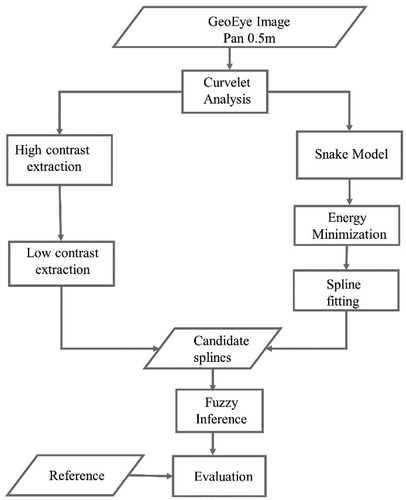
The association between the extracted off-road tracks and animal paths, a grid matching approach was implemented to normalize the sizes of the three pilot sites (Appendix B). Therefore, the two bigger pilot study sites (Site A and Site B) were subdivided into a 3 × 3 grid (n = 18) as one grid approximates the size of the third pilot study site (Site C). The off-road tracks and animals’ paths were extracted from each sub-grid and correlated. The total lengths of off-road trails and animal paths were also extracted from the results and divided by the area to obtain the density. The approach followed is summarized in .
Figure 2. Workflow of the conceptualisation and extraction of off-road tracks and animal paths from the GeoEye image.
3. Results
3.1. Evaluation
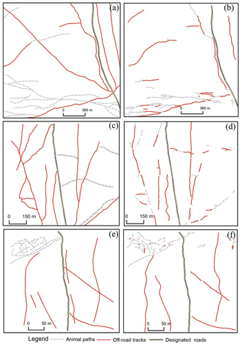
The reference data had a total of 13,215 m of both off-road tracks and animal paths, while the extraction matched 13,153 m of these. This showed that the extraction of trails produced fewer trails than the reference data and therefore under-extracted the lengths of the total trails by 0.5% (62 m) compared to the reference. Most interestingly, there were differences in matching performances between the types of trails, with off-road tracks being under-extracted (shorter) by 4.7% (392 m) of the reference length while animal paths were over-extracted (longer) by 6.9% (331 m). The matched and unmatched trails of both extracted and reference are shown in . The results indicated that the true positives and true negatives were much higher than the false positives and false negatives for both off-road tracks and animal paths. Overall, extraction of both off-road tracks and animal paths was successful and an improvement on any previous attempts ().
Table 1. Correspondence matching for extracted and reference data for off-road tracks and animal paths.
shows that the model generally captures the major skeleton of the distribution and extent of both off-road tracks and animal paths in the study area. The best results were obtained for Site A and Site C . Although the major structure is captured in Site A, there are some misinterpretations in the lower part of the map which confused the animal paths with the off-road trails while missing some vehicle tracks. In Site B, there are more fragmented segments than in the other two sites while in Site C the performance is excellent visually but a few of the vehicle tracks are over curved .
Figure 3. Correspondence matching for extracted and reference data for off-road tracks and animal paths for (a) extraction for the Site A, (b) reference for the Site A, (c) extraction for the Site B, (d) reference for the Site B, (e) extraction for the Site C, and (f) reference for the Site C.
The model performance across the quantitative performance metrics (completeness, correctness, redundancy) for both off-road tracks and animal paths that were used for the evaluation are shown in . Redundancy had the lowest score, meaning that not many of the extracted curvilinear features were repeating extraction. The results of the categorical accuracy in terms of categorization of the trails as off-road tracks or animal paths were satisfactory with a mean of 79.5% but varied between sites between 68% (Site B) and 97.6% (Site C) after weighting them using the total length of trails in each site (). The overall accuracy for the extraction was 79.5%.
Table 2. Correspondence matching for extracted and reference data for off-road tracks and animal paths across the three sites.
3.2. Density and association of off-road tracks and animal paths
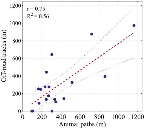
After gaining sufficient confidence that the extraction worked well, we assessed the general density and association of off-road tracks and animal paths in the three pilot study sites. Assessing the extraction showed that the distribution of the off-road tracks and animal paths varied considerably across the sites, with some areas having a higher density of trails than others. Using grid matching, we find a high correlation between off-road vehicle tracks and animal paths in the area (r = 0.75, p < 0.05) indicating co-occurrence of the two types of trails in the area (). We found a density of 2799 m/km2 and 4436 m/km2 of animal paths and off-road tracks across the three test sites, respectively.
Figure 4. Scatter plot showing the relationship between off-road tracks and animal paths from 19 sub-grids created across the three pilot study sites.
4. Discussion
This study applies a curvelet-based sequential approach for accurately detecting, mapping, and separating off-road tracks and animal paths in a complex and heterogeneous protected area from very high-resolution satellite imagery. Such an approach is needed for various environmental and scientific applications in conservation science and park management. Mapping and quantifying off-road tracks and animal paths helps in the understanding of the movement of animals and vehicles in the park, which allows reserve management to understand threatened ecosystems by routinely being able to monitor these and understand changes. Threats to the ecosystem are represented by illegal poaching of animals, trees, and other natural resources. These activities are supported by unofficial roads, thus tracking distribution and changes supports conservation management and law enforcement. The results of our study provide a standardized method for coming up with baseline data on the extent, distribution and intensity of both off-road tracks and animal paths that can be used to assess or link climate, biomass, tourist pressure and other factors to the trails’ distribution and patterns across space and time. Therefore, we report a novel method of using a satellite-based multi-stage algorithm and automated characterization of trails, which are increasingly becoming essential features in protected areas, not only in the Masai Mara ecosystem but in protected areas and other landscapes worldwide.
From an ethological perspective, understanding the movement patterns of wildlife (the animal path distribution) in relation to human factors (the off-road tracks) is useful to better understand human–wildlife interactions. Better understanding of shifting animal migration patterns, which are increasingly being attributed to climate change and increasing human presence in rural landscapes (Kubelka et al. Citation2022; Rickbeil et al. Citation2019), is useful for wildlife management, particularly in cross-border areas. Such information is important for biodiversity because of the impact of vehicles on vegetation trampling and soil compaction and associated impacts on water infiltration, erosion and groundwater recharge (Nortjé, Van Hoven, and Laker Citation2012; Switalski Citation2018), effects plant and animal biodiversity and its distribution patterns together with downstream and long-term impacts on ecosystem functioning and tourism (Bury Citation1980; Hammitt, Cole, and Monz Citation2015; Jahani, Goshtasb, and Saffariha Citation2020; Lucas Citation2020; Westekemper et al. Citation2018).
Attempts to extract roads from remotely sensed data have a long history with various levels of success reported with most of the approaches using machine learning, knowledge-based algorithms and mathematical morphology (Chen et al. Citation2022; Lian et al. Citation2020; Lucas Citation2020). However, although ordinary tarmac and gravel roads can be challenging to extract because of background features and similar radiometric and geometric features in surroundings, extracting off-road tracks and animal paths is more complicated than ordinary roads. The success of various road extraction methods depends on the datasets and the algorithms applied. Chen et al. (Citation2022) summarizes these performance measures. Using this as a reference, the performance measures reported in this study are in the range of those reported for ordinary road extraction. In summary, our approach advances current remote sensing applications in three ways.
Firstly, the information on off-road tracks and animal paths provides a composite indicator of both human and wildlife footprints on precarious ecosystems such as the Masai Mara National Reserve and the environment in general. Studies have widely reported the impact of recreation activities on wildlife resource utilization (Baker, Leberg, and Viña Citation2018; Maldonado-Ore and Custodio Citation2020; Pickering Citation2010), wildlife behaviour (Lei et al. Citation2022; Westekemper et al. Citation2018) and vegetation dynamics (Pickering and Hill Citation2007). However, there was always a need to quantify the extent of the footprint of off-road tracks to appropriately link it to observed impacts, yet novel approaches are yet to be available. Therefore, this study applies a method to detect off-road tracks and wildlife paths in an important protected area that is part of a significant ecosystem. The method is transferable to other regions with re-training using new imagery.
Secondly, the approach applied enables automated satellite-based mapping and quantification of off-road vehicle tracks and animal paths that provide, on the one hand, the extent of the trails and, on the other, a baseline on which future changes in pattern and distribution of the trails can be compared to identify landscape changes. Back-transformation of the curvelet coefficients into the spatial domain produces maps that show where and how much of the landscape is impacted by off-road tracks and animal paths. Armed with such information, park managers can monitor hotspots of off-road tracks and implement specific measures such as installing signage limiting tourists from officially designated roads or establishing regenerative management activities to restore already degraded areas from off-road tracks (Westekemper et al. Citation2018).
Thirdly and perhaps most importantly, such information provides detailed data on which patterns in wildlife (animal paths) and human (off-road tracks) can be analysed and explained, including correlations between the two. Pattern analysis of the trails after being extracted provides a potential value for ecological applications such as eco-tourism impact studies, national park management, local agencies, and researchers interested in animal behaviour. The analysis of patterns should, however, not be restricted to the density and prevalence of each kind of trail but also the distances and co-occurrence of off-road tracks and animal paths. For example, Whiteman and Buskirk (Citation2013), after analysing areas with snow sports, concluded that animal foot load positively influenced the probability of animals following compacted transects and positively influenced their following distance, with implications on their habitat selection, utilization, dispersal and competitive and predatory success. The trails have also been reported to have other impacts on other wildlife such as birds (Thompson Citation2015), bears (Kirby, Alldredge, and Pauli Citation2016) and other animals (Sarmento and Berger Citation2017). Other geometric pattern analyses of the trails (especially animal paths) such as parallel, spark-like, or tree-like, can reveal certain kinds of natural laws or systematic impacts on nature. These can be used predictively when combined with other variables such as distance to water sources, soil quality (and, by inference, vegetation), geology and/or distance from human factors such as camps or fences.
The findings of the density of off-road tracks and animal paths from our samples appear high, although this requires a value judgement of what the maximum threshold allowable for off-road trails is. We also do not take a position on whether human interaction especially through eco-tourism is good or bad for wildlife (Hovius, Hovius, and Criscione-Naylor Citation2023) as this study only provides an objective way and first results from satellite-based automatic extraction of off-road tracks and animal paths with high radiometric variability and a complexity of the background through an innovative multistage approach. However, it is important to note that high density of off-road tracks occurred in areas where wild animals’ paths were also high. Protected area managers can therefore concentrate their efforts on controlling off-road drives in areas with high wildlife density in Maasai Mara National Re-serve and other protected areas.
Future research could improve results by applying deep learning approaches on a large scale and include a multi-temporal component (seasonal or multi-year) and multi-spectral data to extract vehicle off-road trails and animal paths from satellite data. Multi-temporal analysis of the images for off-road tracks and animal paths can identify the seasonality or inter-annual variation in the trails, an important aspect to determining their ecological impacts. Multi-spectral data could use more spectral information in other bands to detect the trails instead of just relying on the panchromatic band alone. Further, computational requirements can also be reduced by applying a more memory-efficient approach for this and related tasks.
5. Conclusions
We apply a satellite-based automated approach to simultaneously map and quantify off-road tracks and animal paths in a heterogeneous environment. The approach is based on a multi-stage implementation framework to leverage various algorithms to produce accurate results and efficient applications to deal with complex data problems. It was evaluated using three complex sites, all in the Masai Mara ecosystem. From this study, it can therefore be concluded that (i) curvelet-transform coefficients can be used to map off-road tracks and animal paths accurately, (ii) the density and spatial distribution of both trails can be satisfactorily quantified from satellite data for ecological applications and (iii) both wildlife and human footprints modify the characteristics and quality of natural ecosystems such as the Masai Mara. There is a need to leverage our approach to develop and apply more advanced and memory-efficient satellite-based methods and less costly satellite data options to detect and quantify off-road tracks and animal paths at a large scale in protected areas. Deep learning and recent multispectral and hyperspectral missions could play a role here. Therefore, we hope that future developments utilize improvements in spatial and radiometric resolutions of satellites to create data on off-road tracks and animal paths that can be used to understand animal and human behaviour and ultimately contribute data towards making better-informed conservation management decisions.
Supplementary_materials.docx
Download MS Word (1.2 MB)Acknowledgements
This research was performed while I.D. held an NRC Research Associateship award from the National Academy of Sciences. The study was also made possible by the EU Erasmus Fellowship awarded to S.L.
Disclosure statement
No potential conflict of interest was reported by the author(s).
Data availability statement
The authors confirm that all data underlying the findings are fully available without restriction. The use of the satellite imagery was authorized by the DigitalGlobe Foundation, and it can be downloaded on Dryad https://doi.org/10.5061/dryad.v6wwpzh3j.
Supplementary material
Supplemental data for this article can be accessed online at https://doi.org/10.1080/01431161.2024.2377230
References
- Abdollahi, A., B. Pradhan, N. Shukla, S. Chakraborty, and A. Alamri. 2020. “Deep Learning Approaches Applied to Remote Sensing Datasets for Road Extraction: A State-Of-The-Art Review.” Remote Sensing 12 (9): 1444. https://doi.org/10.3390/rs12091444.
- Baker, A. D., P. L. Leberg, and A. Viña. 2018. “Impacts of Human Recreation on Carnivores in Protected Areas.” PLOS ONE 13 (4): e0195436. https://doi.org/10.1371/journal.pone.0195436.
- Belsoy, J., J. Korir, and J. Yego. 2012. “Environmental Impacts of Tourism in Protected Areas.” Journal of Environment & Earth Science 2 (10): 64–73.
- Bury, R. B. 1980. “What We Know and don’t Know About Off-Road Vehicle Impacts on Wildlife.” In Off-Road Vehicle Use: A Management Challenge, edited by P. F. Nowak, 1110–123. Washington, D.C.: USDA Office of Environmental Quality.
- Candès, E. 1998. Ridgelets: Theory and Applications. PhD Thesis, Stanford University.
- Candès, E., L. Demanet, D. Donoho, and L. Ying. 2006. “Fast Discrete Curvelet Transforms.” Multiscale Modeling and Simulation 5 (3): 861–899. https://doi.org/10.1137/05064182X.
- Candès, E., and D. Donoho. 1999. Curvelets: A Surprisingly Effective Nonadaptive Representation of Objects with Edges. Nashville: Vanderbilt University.
- Candès, E. J., and F. Guo. 2002. “New Multiscale Transforms, Minimum Total Variation Synthesis: Applications to Edge-Preserving Image Reconstruction.” Signal Processing 82 (11): 1519–1543. https://doi.org/10.1016/S0165-1684(02)00300-6.
- Chavan, V., J. Shah, M. Vora, M. Vora, and S. Verma. 2020. “A Review on Feature Extraction Methods for Image Analysis.” In Proceedings of the 3rd International Conference on Advances in Science & Technology (ICAST), Mumbai, India.
- Chen, Z., L. Deng, Y. Luo, D. Li, J. Marcato Junior, W. Nunes Gonçalves, A. Awal Md Nurunnabi, et al. 2022. “Road Extraction in Remote Sensing Data: A Survey.” International Journal of Applied Earth Observation and Geoinformation 112:102833. https://doi.org/10.1016/j.jag.2022.102833.
- Fadili, J. M., and J.-L. Starck. 2009. Curvelets and Ridgelets. New York, NY: Springer.
- Geback, T., and P. Koumoutsakos. 2009. “Edge Detection in Microscopy Images Using Curvelets.” BMC Bioinformatics 10 (1): 75. https://doi.org/10.1186/1471-2105-10-75.
- Griggs, G., and B. Walsh. 1981. “The Impact, Control, and Mitigation of Off-Road Vehicle Activity in Hungry Valley, California.” Environmental Geology 3 (4): 229–243. https://doi.org/10.1007/BF02473507.
- Hammitt, W. E., D. N. Cole, and C. A. Monz. 2015. Wildland Recreation: Ecology and Management. Oxford, UK: John Wiley & Sons.
- Heipke, C., Hélene Mayer, Christian Wiedemann, and Olivier Jamet. 1997. “Evaluation of Automatic Road Extraction.” International Archives of Photogrammetry and Remote Sensing 32 (3 SECT 4W2): 151–160.
- Hovius, K., L. Hovius, and N. Criscione-Naylor. 2023. “An Analysis of Challenges Facing the Growth and Development of Ecotourism.” International Journal of Gaming, Hospitality and Tourism 3 (1): 1–6.
- Jahani, A., H. Goshtasb, and M. Saffariha. 2020. “Tourism Impact Assessment Modeling of Vegetation Density for Protected Areas Using Data Mining Techniques.” Land Degradation & Development 31 (12): 1502–1519. https://doi.org/10.1002/ldr.3549.
- Jia, J., H. Sun, C. Jiang, K. Karila, M. Karjalainen, E. Ahokas, E. Khoramshahi, et al. 2021. “Review on Active and Passive Remote Sensing Techniques for Road Extraction.” Remote Sensing 13 (21): 4235. https://doi.org/10.3390/rs13214235.
- Jianwei, M., A. Antoniadis, and F. X. Le Dimet. 2006. “Curvelet-Based Snake for Multiscale Detection and Tracking of Geophysical Fluids.” Geoscience and Remote Sensing, IEEE Transactions On 44 (12): 3626–3638. https://doi.org/10.1109/TGRS.2006.885017.
- Kainz, W. 2002. “Fuzzy Logic and GIS.” http://homepage.univie.ac.at/wolfgang.kainz/Lehrveranstaltungen/ESRI_Fuzzy_Logic/File_2_Kainz_Text.pdf2012.
- Kass, M., A. Witkin, and D. Terzopoulos. 1988. “Snakes: Active Contour Models.” International Journal of Computer Vision 1 (4): 321–331. https://doi.org/10.1007/BF00133570.
- Kirby, R., M. W. Alldredge, and J. N. Pauli. 2016. “The Diet of Black Bears Tracks the Human Footprint Across a Rapidly Developing Landscape.” Biological Conservation 200:51–59. https://doi.org/10.1016/j.biocon.2016.05.012.
- Kubelka, V., B. K. Sandercock, T. Székely, and R. P. Freckleton. 2022. “Animal Migration to Northern Latitudes: Environmental Changes and Increasing Threats.” Trends in Ecology & Evolution 37 (1): 30–41. https://doi.org/10.1016/j.tree.2021.08.010.
- Laptev, I., H. Mayer, T. Lindeberg, W. Eckstein, C. Steger, and A. Baumgartner. 2000. “Automatic Extraction of Roads from Aerial Images Based on Scale Space and Snakes.” Machine Vision and Applications 12 (1): 23–31. https://doi.org/10.1007/s001380050121.
- Lei, B., Z. Zheng, J. Cui, J. Zhao, C. Newman, and Y. Zhou. 2022. “Ecotourist Trail‐Use Affects the Taxonomic, Functional and Phylogenetic Diversity of Mammals in a Protected Area: Lessons for Conservation Management.” Integrative Zoology 18 (4): 647–660. https://doi.org/10.1111/1749-4877.12688.
- Li, H., G. Han, Z. Wu, and X. Song. 2022. “Pansharpening with the Multidirection Tree Ridgelet Dictionary.” Mathematical Problems in Engineering 2022:1–14. https://doi.org/10.1155/2022/3798696.
- Lian, R., W. Wang, N. Mustafa, and L. Huang. 2020. “Road Extraction Methods in High-Resolution Remote Sensing Images: A Comprehensive Review.” IEEE Journal of Selected Topics in Applied Earth Observations & Remote Sensing 13:5489–5507. https://doi.org/10.1109/JSTARS.2020.3023549.
- Liu, P., Q. Wang, G. Yang, L. Li, and H. Zhang. 2022. “Survey of Road Extraction Methods in Remote Sensing Images Based on Deep Learning.” PFG – Journal of Photogrammetry, Remote Sensing and Geoinformation Science 90 (2): 135–159. https://doi.org/10.1007/s41064-022-00194-z.
- Lucas, E. 2020. “A Review of Trail-Related Fragmentation, Unauthorized Trails, and Other Aspects of Recreation Ecology in Protected Areas.” California Fish and Wildlife Journal 95–125. https://doi.org/10.51492/cfwj.recreationsi.6.
- Maboudi, M., J. Amini, S. Malihi, and M. Hahn. 2018. “Integrating Fuzzy Object Based Image Analysis and Ant Colony Optimization for Road Extraction from Remotely Sensed Images.” Isprs Journal of Photogrammetry & Remote Sensing 138:151–163. https://doi.org/10.1016/j.isprsjprs.2017.11.014.
- Maldonado-Ore, E. M., and M. Custodio. 2020. “Visitor Environmental Impact on Protected Natural Areas: An Evaluation of the Huaytapallana Regional Conservation Area in Peru.” Journal of Outdoor Recreation and Tourism 31:100298. https://doi.org/10.1016/j.jort.2020.100298.
- Mena, J. B. 2003. “State of the Art on Automatic Road Extraction for GIS Update: A Novel Classification.” Pattern Recognition Letters 24 (16): 3037–3058. https://doi.org/10.1016/S0167-8655(03)00164-8.
- Menet, S., P. Saint-Marc, and G. Medioni. 1990. “Active Contour Models: Overview, Implementation and Applications.” In 1990 IEEE International Conference on Systems, Man, and Cybernetics Conference Proceedings, Los Angeles, California, USA, 194–199.
- Michaelsen, E., and J. Meidow. 2019. “Knowledge and Gestalt Interaction.” In Hierarchical Perceptual Grouping for Object Recognition. Advances in Computer Vision and Pattern Recognition. Cham: Springer. https://doi.org/10.1007/978-3-030-04040-6_12.
- Mnih, V., and G. Hinton. 2010. “Learning to Detect Roads in High-Resolution Aerial Images.” In Computer Vision – ECCV 2010, edited by K. Daniilidis, P. Maragos, and N. Paragios, 210–223. Berlin: Springer Berlin/Heidelberg.
- Nortje, G. P. 2014. Studies on the Impacts of Off-Road Driving and the Influence of tourists’ Consciousness and Attitudes on Soil Compaction and Associated Vegetation in the Makuleke Contractual Park, Kruger National Park. Pretoria, South Africa: University of Pretoria.
- Nortjé, G. P., W. Van Hoven, and M. C. Laker. 2012. “Factors Affecting the Impact of Off-Road Driving on Soils in an Area in the Kruger National Park, South Africa.” Environmental Management 50 (6): 1164–1176. https://doi.org/10.1007/s00267-012-9954-y.
- Pickering, C. M. 2010. “Ten Factors That Affect the Severity of Environmental Impacts of Visitors in Protected Areas.” AMBIO: A Journal of the Human Environment 39 (1): 70–77. https://doi.org/10.1007/s13280-009-0007-6.
- Pickering, C. M., and W. Hill. 2007. “Impacts of Recreation and Tourism on Plant Biodiversity and Vegetation in Protected Areas in Australia.” Journal of Environmental Management 85 (4): 791–800. https://doi.org/10.1016/j.jenvman.2006.11.021.
- Ploughe, L. W., and L. H. Fraser. 2022. “Find New RoadsTM? A Systematic Review on the Impacts of Off-Road Vehicle Activity on Soil, Vegetation, and Wildlife.” Frontiers in Ecology and Evolution 9:805707. https://doi.org/10.3389/fevo.2021.805707.
- Priskin, J. 2003. “Physical Impacts of Four-Wheel Drive Related Tourism and Recreation in a Semi-Arid, Natural Coastal Environment.” Ocean & Coastal Management 46 (1–2): 127–155. https://doi.org/10.1016/S0964-5691(02)00124-2.
- Puranikmath, S. S., and K. Vani. 2016. “Enhancement of SAR Images Using Curvelet with Controlled Shrinking Technique.” Remote Sensing Letters 7 (1): 21–30.
- Rastiveis, H., A. Shams, W. A. Sarasua, and J. Li. 2020. “Automated Extraction of Lane Markings from Mobile LiDAR Point Clouds Based on Fuzzy Inference.” Isprs Journal of Photogrammetry & Remote Sensing 160:149–166. https://doi.org/10.1016/j.isprsjprs.2019.12.009.
- Rickbeil, G. J. M., J. A. Merkle, G. Anderson, M. P. Atwood, J. P. Beckmann, E. K. Cole, A. B. Courtemanch, et al. 2019. “Plasticity in Elk Migration Timing Is a Response to Changing Environmental Conditions.” Global Change Biology 25 (7): 2368–2381. https://doi.org/10.1111/gcb.14629.
- Sarmento, W. M., and J. Berger. 2017. “Human Visitation Limits the Utility of Protected Areas As Ecological Baselines.” Biological Conservation 212:316–326. https://doi.org/10.1016/j.biocon.2017.06.032.
- Senthilnath, J., M. Rajeshwari, and S. Omkar. 2009. “Automatic Road Extraction Using High Resolution Satellite Image Based on Texture Progressive Analysis and Normalized Cut Method.” The Journal of the Indian Society of Remote Sensing 37 (3): 351–361. https://doi.org/10.1007/s12524-009-0043-5.
- Sinha, S., E. H. Teli, and R. Sivakumar. 2021. “Applications of Curvelet Transform: A Review.” 2021 Innovations in Power and Advanced Computing Technologies (i-PACT), Kuala Lumpur, Malaysia, 01–09. https://doi.org/10.1109/i-PACT52855.2021.9696587.
- Starck, J. L., F. Murtagh, E. J. Candes, and D. L. Donoho. 2003. “Gray and Color Image Contrast Enhancement by the Curvelet Transform.” Image Processing, IEEE Transactions On 12 (6): 706–717. https://doi.org/10.1109/TIP.2003.813140.
- Switalski, A. 2018. “Off-Highway Vehicle Recreation in Drylands: A Literature Review and Recommendations for Best Management Practices.” Journal of Outdoor Recreation and Tourism 21:87–96. https://doi.org/10.1016/j.jort.2018.01.001.
- Thompson, B. 2015. “Recreational Trails Reduce the Density of Ground-Dwelling Birds in Protected Areas.” Environmental Management 55 (5): 1181–1190. https://doi.org/10.1007/s00267-015-0458-4.
- Tieling, C., W. Jinfei, and Z. Kaizhong. 2002. “A Wavelet Transform Based Method for Road Extraction from High-Resolution Remotely Sensed Data.” In Geoscience and Remote Sensing Symposium, 2002. IGARSS ’02. 2002 IEEE International, vol. 3366, 3369–3371. Toronto, Ontario, Canada.
- van Vierssen Trip, N., and Y. F. Wiersma. 2015. “A Comparison of All-Terrain Vehicle (ATV) Trail Impacts on Boreal Habitats Across Scales.” Natural Areas Journal 35 (2): 266–278. https://doi.org/10.3375/043.035.0207.
- Walpole, M. J. 2003. Wildlife and People: Conflict and Conversation in Masai Mara, Kenya. UK: International Institute for Environment and Development.
- Wang, W., N. Yang, Y. Zhang, F. Wang, T. Cao, and P. Eklund. 2016. “A Review of Road Extraction from Remote Sensing Images.” Journal of Traffic and Transportation Engineering (English Edition) 3 (3): 271–282. https://doi.org/10.1016/j.jtte.2016.05.005.
- Wessel, B., C. Wiedemann, O. Hellwich, and W. C. Arndt. 2002. “Evaluation of Automatic Road Extraction Results from SAR Imagery.” The International Archives of Photogrammetry, Remote Sensing & Spatial Information Sciences 34 (4): 786–791.
- Westekemper, K., H. Reinecke, J. Signer, M. Meißner, S. Herzog, and N. Balkenhol. 2018. “Stay on Trails–Effects of Human Recreation on the Spatiotemporal Behavior of Red Deer Cervus elaphus in a German National Park.” Wildlife Biology 2018 (1): 1–9. https://doi.org/10.2981/wlb.00403.
- Whiteman, J. P., and S. W. Buskirk. 2013. “Footload Influences Wildlife Use of Compacted Trails in the Snow.” Wildlife Biology 19 (2): 156–164. https://doi.org/10.2981/12-112.
- Wilson, J. P., and J. P. Seney. 1994. “Erosional Impact of Hikers, Horses, Motorcycles, and Off-Road Bicycles on Mountain Trails in Montana.” Mountain Research and Development 14 (1): 77–88. https://doi.org/10.2307/3673739.
- Wolf, I. D., D. B. Croft, and R. J. Green. 2019. “Nature Conservation and Nature-Based Tourism: A Paradox?” Environments 6 (9): 104. https://doi.org/10.3390/environments6090104.
- Wulamu, A., Z. Shi, D. Zhang, and Z. He. 2019. “Multiscale Road Extraction in Remote Sensing Images.” Computational Intelligence and Neuroscience 2019:1–9. https://doi.org/10.1155/2019/2373798.
- Ying, L., H. Gong, D. Feng, and Y. Zhang. 2011. “An Adaptive Method of Speckle Reduction and Feature Enhancement for SAR Images Based on Curvelet Transform and Particle Swarm Optimization.” Geoscience and Remote Sensing, IEEE Transactions On 49 (8): 3105–3116. https://doi.org/10.1109/TGRS.2011.2121072.