ABSTRACT
The post-Roman evolution of the landscape of coastal east Lincolnshire exhibits regional links from early medieval times in the case of major fen and sea banks, to which can be added local links and actions for bank-building, pasture reclamation, harbours, fisheries, and the impress of local government. In a landscape much defined by water, now largely insignificant watercourses were once the scene of considerable concern. In the case of the Lymn, the instrumental role played by local magnates is dominant, but the input of local communities in undertaking and often benefiting from the actual labour also diversifies the overall picture. The Supplementary Material facility is used to expand on a number of points germane, but not central, to the main narrative.
ACKNOWLEDGEMENTS
A generous donation by the late Arthur Owen FSA enabled the sight, collection and translation of the documents cited and these were processed by Patrick Mussett. He should not be charged with the interpretations of the material set out here. The staff of the National Archives at Kew and of the NMR (National Monument Record, now Historic England) at Swindon were very helpful, as were those of the Lincolnshire Archives; at the Bethlem Royal Hospital, Colin Gale was supportive from the very start. Discussion of various aspects of the study with Tom Lane, Mark Bennet, Rob Wheeler and Martin Redding were always stimulating. The willingness of Christina Belton to direct her light aircraft towards interesting places and take custom photographs is gratefully acknowledged. I am thankful for continued access to facilities at Durham University and especially the skills of Chris Orton in converting sketches in coloured pencil to publishable graphics.
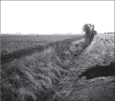
Plate I. Plate II.The Lusdyke meets Wainfleet Haven just behind the camera. Only the line of the ditch marks the original course of the key feature of the water supply to the harbour of Wainfleet All Saints during medieval and early modern times (Author's photograph, March 2003).