
ABSTRACT
This paper considers large-scale erosion of late medieval peatland landscapes along the inland lagoon rims of the north-eastern Zuyder Zee area (today: Noordoostpolder, the Netherlands) and integrates palaeogeographical reconstruction, material archeological and spatial archaeohistorical research. The dynamic regional history of coeval loss of peaty coastal plains and boom of maritime activities is studied from archaeological, geological and historical data perspectives. In the first half of the Middle Ages (a.d. 500–1000), vast peatlands and interconnected lakes characterised the study area. During the late Middle Ages (a.d. 1000–1500), increased storm surges and tidal incursions allowed for extensive progressive erosion of inhabited peatlands, transforming the central Netherlands into the Zuyder Zee tidal lagoon. In the north-eastern quadrant of the expanding water body, medieval terrestrial geological and archaeological records fell prey to erosion, re-working and uptake into lagoon-floor deposits. These deposits have been intensively surveyed since the 1940s when the quadrant was reclaimed and made into arable land, and are revealed to contain spatially clustered late medieval archaeological objects.
Whereas lagoon floor re-working has hindered making a detailed palaeogeographical reconstruction based on geological data alone, including the mapping of archaeology has helped resolve the pacing of lagoon expansion. The key to resolving the lost peatland palaeogeography for the time frames 1100 and 1400, was to put the archeological data density patterns first and geological lagoon-floor facies descriptions second in process order, while for earlier periods or other regions the opposite order is the convenient choice. We present a map series beginning with an updated map for a.d. 900 (the youngest geological reconstruction), introducing the first detailed palaeogeographical maps for 1100 and 1400 (honouring the late medieval terrestrial and maritime archaeological evidence) and ending with a landscape reconstruction for 1600 (complying with the oldest historical maps of the lagoon), revealing the intertwined landscape history of land and sea as the backdrop for shifts in the human use of both.
INTRODUCTION
This paper presents a reconstruction of the highly dynamic maritime landscape development of the Noordoostpolder region, that is the north-eastern part of the former Zuyder Zee in the central Netherlands, in the later part of the Middle Ages (). In 1942, the Noordoostpolder was reclaimed and transformed into the modern agricultural landscape. The name Zuyder Zee (‘Southern Sea’) is connected to the late medieval greatly expanded central Netherlands’ lagoon: a continuous inland water body resulting from the progressive erosion of medieval peatland landscapes connected to the North Sea via widened tidal inlets of the western Wadden Sea (e.g. Wiggers Citation1955; Vos Citation2015; Van den Biggelaar et al. Citation2014; Pierik et al. Citation2017; Van Popta Citation2017). Before this Zuyder Zee tidal ingression and lagoon expansion came to be, the lost landscapes of the Dutch coastal plain consisted of extensive peat bogs, fens and local lakes, through which rivers ran. A substantial part of these wetland landscapes was lost to medieval ingressions, but an equally substantial part was reclaimed and inhabited at the time, caused by early medieval habitation on the boulder clay outcrops as well as large-scale agrarian peatland reclamations in the tenth–twelfth centuries (Wiggers Citation1955; Van der Heide Citation1965; Geurts Citation2005; Mol Citation2011; Van Popta & Aalbersberg Citation2016). Hence, palaeogeographical research into the expansion of the Zuyder Zee and conditions of its wetland fringe from protohistoric into historic times is advised in order to cover the detailed investigation of natural as well as human landscape developments, and to include the way in which former inhabitants adapted their physical environment, economy and social structures to these vigorous changes (Vos Citation2015; Pierik et al. Citation2017). Performing such research can provide relevant insights into the natural and cultural history of the lagoon landscape, and should be considered as a methodological case study in the archaeology of drowned and reclaimed lands.
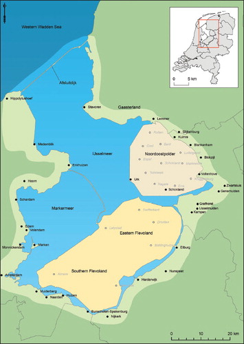
Fig. 1. Topographical map of the Zuyder Zee region in the centre part of the Netherlands. The modern settlements in the Province of Flevoland are highlighted in grey italics.
state of research
The geology, history and archaeology of the Noordoostpolder have been closely examined in the past, especially at the time when the polder fell dry and was put into use in a time of 1940/’50s rationalism with a strong focus on agricultural optimisation for food production, for which a detailed understanding of the soil and subsoil was required (). The new and very diverse dataset developed in this period has been used by various scholars for answering questions on the origin and history of the Zuyder Zee region, leading to detailed studies on terrestrial and tidal-lagoonal palaeoenvironmental development (e.g. Wiggers Citation1955; Van der Heide Citation1965; Gotjé Citation1993; Ten Anscher Citation2012) and to archaeological investigations of the first (prehistoric) inhabitants besides many investigations regarding the rich maritime past of the region (De Boer & Geurts Citation2002; Geurts Citation2005; Van Hezel & Pol Citation2008; Van Popta & Aalbersberg Citation2016; Van Popta Citation2017; Van Popta & Van Holk Citation2018). The Noordoostpolder is also part of multiple detailed regional (Wiggers Citation1955; Ten Anscher Citation2012) and more general national palaeogeographical studies (Zagwijn Citation1986; De Mulder et al. Citation2003; Vos & De Vries Citation2013; Vos Citation2015). When connecting all these bodies of work, important changes in natural conditions and types of human presence throughout the history of the region are covered.
Different ideas compete regarding the eventual establishment of the Zuyder Zee as a large brackish tidal lagoon early in the second millennium a.d. These differences especially consider the southern and south-western sectors of the Zuyder Zee, where the peat-rim eroding lagoon assimilated precursor lagoonal and lake water bodies. The commencement of the Zuyder Zee is seen as the culmination of a process that began with expansion and growing interconnection ‘Lake Flevo’/ ‘Lacus Flevo’ and ‘Almere’/ ‘Almaere’ during the last centuries b.c. and the first millennium a.d. Timing and mechanisms of successive phases are the subject of ample discussion (recent exchanges of arguments found in Buitelaar & Borger Citation2015; Vos Citation2015; Vos et al. Citation2015; Pierik et al. Citation2017; Borger & Kluiving Citation2017; Van Zijverden Citation2017).
Our position here is that these debates primarily consider the timing and order of events in regions away from the Noordoostpolder (our Results section contains a synopsis). If we plan to investigate the Noordoostpolder area and consider its palaeogeography in Iron Age, Roman and early medieval times, it is fully accepted (see Results: reconstruction maps reconstructed) that the region at that time drained towards the Vlie tidal inlet. There is little debate that this inlet water body was gradually expanding south and south-eastwards, turning inland waters from fresh to brackish and causing erosion and inundation of peatlands, already before the Zuyder Zee was established (i.e. within the first millennium a.d.) and continuing during its commencement (i.e. at the turn of the second millennium).
However, the time period when coastal land changed into inland sea, say the late Middle Ages, remains a complicated and largely unknown period of study, not only for the Noordoostpolder, but for the whole Zuyder Zee region. National palaeogeographical studies have skipped this period by reconstructing the Zuyder Zee region centuries before marine erosion (a.d. 800) and the post-medieval landscape after marine erosion (1500). Previous archaeological and historical studies do mention the loss of land in the late Middle Ages and the presumed submergence of settlements but are often not explicit enough (see: Geurts Citation1991; Citation2005; Hogestijn Citation1992; Van den Biggelaar et al. Citation2014; Van Popta Citation2017).
problem definition
Given the landscape change described above, it is time to reconsider all the data presently available for the Noordoostpolder region, in order to produce a new and independent palaeogeographical map time series for the medieval period. Depicting the symbiotic relationship between landscape development and human presence during the late Middle Ages has been avoided, and hence remained neglected in nationalscale palaeogeographical reconstructions. Time series tend to skip the critical period, jumping from a.d. 900 to 1500 (Vos Citation2015). If we focus on the regional reconstructions made for the area in the early Middle Ages (e.g. a.d. 900) and periods before, considerable attention has been given to fragments of peatlands of that time, that survived in the former island Schokland and its immediate surroundings (e.g. Gotjé Citation1993; Van den Biggelaar et al. Citation2014). The rest of the Noordoostpolder area, however, in these maps does not hold any preserved peatland. Hence, although there are diverse scattered traces of medieval habitation, peatland reclamations, (lost) islands, and former maritime relics in the Noordoostpolder, it remained unaddressed as to what particular medieval landscape was there originally.
Because of areally extensive erosion by the Zuyder Zee, the calved and seafloor re-worked areaslostdirectin-situgeologicalandarchaeological records and therefore were considered unsuitable to inform palaeogeographical reconstructions. It is exactly the reconstructive dealing with surviving archaeological and geological signals of the eroded peatland landscape after Zuyder Zee flooding, calving and lagoon floor re-working — notably in the period 1100 to 1400 — that is in the heart of the research problem addressed here. Data integrations and interdisciplinary interpretations, to be elaborated in new regional palaeogeographical reconstructions, visualised in a map time series, are necessary for exploring and explaining the late medieval developments of the Noordoostpolder and north-eastern and south-eastern fringes in the twelfth to fourteenth century, both natural and cultural, in a spatially explicit way. As this period spans the turnover from a ‘landscape’ to a ‘seascape’ for the area, balanced attention is to be given to indications of sea ingression and land persistence, both where archaeological and where geological data are considered. Furthermore, the period expands the dawn of historical records for the area. Written and map-drawn information on former land use, lost places and changed maritime practice for this area exists, so that the palaeogeographical reconstruction can connect to the sixteenth-century oldest topographic map depictions for the area. The time period and research aimed at thus require an interdisciplinary approach, taking in archaeological, earth scientific, palaeoecological, historical-geographical and medieval historical sources and methods, as has already been noted and advocated in the first years of Noordoostpolder surveying by Van der Heide in 1951 (p. 192). Such research would allow the examination of the extension of the Zuyder Zee, the changes in human land exploitation and the influence of these changes to society from archaeological-historical biographical perspectives. As a result the central research question of this paper is: ‘How did the natural and cultural landscape of the Noordoostpolder change because of maritime erosion in a period of 300 years (1100–1400)?’
Three main research themes are designed for answering the research question. The first theme treats the palaeography of the Zuyder Zee area, meaning relevant Pleistocene and Holocene events that influenced the dynamic development of the Noordoostpolder sector of the Zuyder Zee from a chronological geomorphological and archaeological perspective. Results have been derived from extensive literature and data research. The second theme consists of the analysis of spatial patterns of medieval archaeological and historical data. It uses primary results based on analyses of archaeological objects (terrestrial find clusters) and historical sources (geographically ordered toponyms). The final integrated result, the third theme, is the new palaeogeographical map series of the north-eastern Zuyder Zee area (1100–1400), which is used to present a detailed regional geographic history for the period of a.d. 900 until 1600, with new features and insights highlighted. The (cultural) consequences of land loss will be discussed in a closing section.
METHODOLOGY
materials and data preparation
Multiple types of primary research materials, i.e. datasets derived from different research disciplines, have been used for this research of which a complete overview is presented in Table 1 (see Van Popta Citation2020 for the detailed background). To prepare the raw data for use in improving and newly constructing the palaeogeographical map series, we deployed methods such as find density analysis of late medieval archaeological objects, and geographical analyses of historical charters and maps (again, see Van Popta Citation2020 for the detailed background). The presence of dense concentrations of terrestrial finds indicates that younger lagoon-rim erosion only locally reworked, dispersed and damaged the archeological objects. Surviving concentrations recorded once the Zuyder Zee sea floor was reclaimed still echo locations of past landscape occupation and settlement and, as such, important input to reconstructions. Note that outside marked find clusters, individual archeological objects (1) could have belonged to wrecked ships, (2) could have been deposited in the sea as garbage from ships, (3) could have relatively easily shifted and hence been displaced farther on the former seabed, or (4) can represent other kinds of noise. Hence, such isolated find locations were not used as input for reconstructing settlement locations.
TABLE 1. OVERVIEW OF MOST-USED MATERIALS AND THEIR SCIENTIFIC IMPORTANCE
Besides primary data, we also collected earlier palaeogeographical map series of the study area and direct surroundings, which are principally based on geological data (e.g. Vos Citation2015). Such series visualise sequential landscape change over a given period in a given area. Each map visualises the reconstruction of the landscape at a selected moment in time and stage of development. Crafting such map series over prehistoric and historic time is an established practice (e.g. Pons et al. Citation1963; Zagwijn Citation1983, Citation1986; Ten Anscher Citation2012; Vos Citation2015; Pierik Citation2017; Pierik et al. Citation2017). Even though the views communicated in these maps come across as very realistic, also helped by their graphic styling and intuitive legends, one has to keep in mind that they are interpretative reconstructions of the data as grasped by the author and more certain in some areas than in others, especially in areas later lost to the sea. In many cases, authors were forced to decide on drawing lines at arbitrary guessed positions. Land-water boundary lines, featured on such maps in data-control reality, in fact signal non-clarity zones between areas for which the evidence of ‘land’ or ‘water’ is more convincing (from the nature of sediments, for example).
assembling palaeogeographical maps
For the 1100 and 1400 maps, the purposely prepped archaeology data was used as the primary input in order to reconstruct areas of former peatland. High-density clusters of medieval archeology represent settlement locations on (pen)insular cultivated peatland of the time. Only denser clustering with different object types in relative large quantities was interpreted and used as such. Note that within these find concentrations, the individual archaeological objects may well have been locally displaced and damaged, but not so much or so far that the concentrations diffused to background level.
The flipped strategy of letting archaeological evidence lead the reconstructions over former land surface areas is also functional when reconstructing since when areas were water. For that it uses scattered terrestrial archaeology around concentration centres (see above: the date of the settlement is a terminus ante quem —TAQ — of the time of erosion), as well as the maritime archaeology within lagoon-floor deposits. The distribution of medieval shipwrecks (if reasonably intact) represent watercourses or sea at the time they last sailed, although one should keep in mind that shipwrecks to a certain extent are movable. In the Noordoostpolder, both the terrestrial and the maritime datasets are considered sufficiently rich for executing the density analysis (see Introduction and Approach). Besides choices on what primary materials to use and consider, creating a palaeogeographical map series involves choices of time steps, and complexity and inclusiveness of legend (see also Pierik Citation2017). These are influenced by factors such as the series usage goal (research focus); the scale at which to serve information (national, regional, local); the time window to be covered by the series (Historic, Holocene, Pleistocene); besides the quality and density of the data of the maps (e.g. Vos, Citation2015; Pierik et al. Citation2017). A national palaeogeographical map series can exemplify broad-scale landscape developments, but cannot contain as much detail as a regional palaeogeographical map, not to mention a local map (see also Vos Citation2015). Local maps can be highly detailed, but are also very much tailored to particular themes and purpose (e.g. resolving landscape change at and around sites of specific archaeological interest). The choice on which time stamps to give to a map series may differ greatly between a national map series and a local one of special purpose. Furthermore, geologists and geographers might prefer constant-size time steps for systematically examining changes to the landscape, while archaeologists and historians might prefer unequal time steps that echo cultural, social, economic, and political periodisation.
Mapping the Dutch lowland landscape of 1100 to 1400 has long been considered difficult (see also Vos Citation2015), on the one hand because of the dynamics of storm-surge land loss in many parts of the coastal plain, and on the other hand because of the considerable uncertainty about the ages of man-made embankments (dykes) that were being upgraded from locally to regionally managed features. These two factors apply in particular to the medieval cultivated peatland areas (De Bont Citation2008; Vos Citation2015; Pierik et al. Citation2017). Indeed, the Noordoostpolder study area in the period of interest was affected by both processes of storm-surge land loss and the human peatland occupational processes.
The map series of this research is one on a regional scale in late medieval times (i.e. a.d. 1000–1500), with the maps depicting a slightly larger area than just the Noordoostpolder itself. The choice of map time stamps aimed to bridge the late medieval gap that exists in current national and superregional series, i.e. between maps for a.d. 800 and 1500 (Vos & De Vries Citation2013; Vos Citation2015; Vos et al. Citation2015) and/ or 1575 (Kosian et al. Citation2016). Hereto we introduce new map reconstructions for 1100 and 1400 (extra time steps), and complement these with updated reconstructions for a.d. 900 and 1600 (time steps connecting to national series). One should not forget that the maps are ‘frozen’ reconstructions that can approach realistic situations, but are not full reality. The maps for a.d. 900 and 1600 are strongly based on earlier geological-palaeogeographical historicalgeographical studies respectively. The map for 1100 must be considered as a complete new mapping procedure, with an important role for the density analysis of terrestrial archaeology. The map for 1400 then builds on the 1100 reconstruction, and frames land erosion and loss of settlements, making good use of the historical and maritime archaeological results.
A last important working rule that steered the 1100 reconstruction is the premise that the medieval peatlands were subject to a continuous process of small steps of erosion and incremental decrease. This affected our (modified) reconstructions for a.d. 900, 1100 and 1400. The reconstructions presume that the land loss was the product of a series of large and very large storms over several centuries. A second working rule that steered the interpretative mapping considers the use of the geological mapping of the extent of so-called ‘young detritus gyttja’ beds (Flevomeer- and Almere Beds, Formation of Nieuwkoop). The reconstruction holds this mapping as a constraint for the minimum extent of the Zuyder Zee water body by the end of the early Middle Ages. Eroded peat is deposited as detritus gyttja underwater and therefore represents bodies of water (lakes, channel systems) that date back to at least the Roman period (Wiggers Citation1955, p. 64; Gotjé Citation1993, pp. 9, 110; Ten Anscher Citation2012, pp. 496, 502–3). These lakes increased in size over time due to the peat erosion, caused by strong winds and large waves (Ente et al. Citation1986, p. 130; Gerrets Citation2010, p. 31).
RESULTS
physical geographical setting
As a starting point for medieval to modern landscape change of the Noordoostpolder, the rather diverse Pleistocene and Holocene geomorphological elements of landscapes fringing the Zuyder Zee are briefly characterised first ().
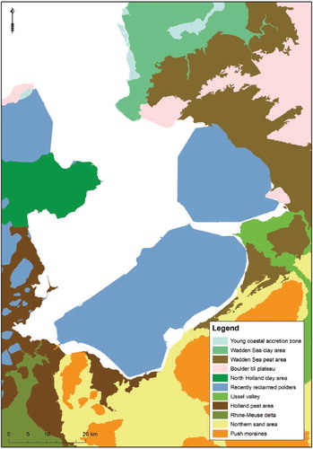
Fig. 2. Archaeological Landscape Map of the Netherlands, clearly depicting the old land (Wadden Sea peat area) and new land (recently reclaimed polders) in the north-eastern Zuyder Zee Region (Rensink et al. Citation2016.).
Pleistocene landforms
During the Pleistocene, North-Western Europe went through multiple ice ages, of which the penultimate glacial (c. 150,000 years ago; the last part of the Saalian) left prominent relief in the study area. The south-western front of the Scandinavian Ice Sheet overran the north of the Netherlands, including the Noordoostpolder. It transformed the subsoil into push moraines (formed due to the pushing of sediments by a glacier or ice sheet) and ground moraines (an irregular blanket of till deposited under a glacier) and left glaciogenic aligned ridges and lows dissected by meltwater valleys (Wiggers Citation1955, p. 19; Ter Wee Citation1962; Kluiving et al. Citation1991; Gotjé Citation1993, p. 15; Busschers et al. Citation2008). When the land ice melted, large amounts of erratic boulders and patches of stiff layers of clayey till (boulder clay, keileem) were left behind (e.g. at Urk & Vollenhove: Bosch et al. Citation2000, p. 139). During the Last Interglacial (Eemian; c. 125,000– 115,000 years ago), the central Netherlands were inundated by a marine embayment connected to the North Sea (Zagwijn Citation1983; Peeters et al. Citation2016). The area covered by the inland sea was comparable to that of the Zuyder Zee. In the Last Glacial (Weichselian; c. 115,000 years ago — 9700 b.c.), the Netherlands were not covered by land ice but phases of mildly cooler to severely colder climate (relative to present) alternated repeatedly (e.g. Zagwijn Citation1989; Bohncke Citation1993; Hoek Citation2000). Frozen and barren conditions allowed large amounts of sand to be mobilised by the wind. Admixed with snow these shifted sands were redeposited as so-called coversand deposits, resulting in a series of low sand dunes over a partly deflated, partly buried, substrate (Van der Hammen Citation1951; Kasse Citation2002; Schokker et al. Citation2007).Footnote1 Meanwhile, smaller rivers like the Linde and Kuinder (fed from snowmelt on the till plateau to the north-east), and the larger rivers Vecht (its catchment reaching east into Münsterland: Van Huissteden et al. Citation1986) and, in the beginning of the glacial, even the Rhine (the northerly course was abandoned half way through the Weichselian; (Busschers et al. Citation2007; Peeters et al. Citation2016), worked their ways through the open lowlands of the study area. The last severe cold phase peaked around 20,000 b.c. and major cover sand displacement, river bed widening and aggradation characterised the period following it (Late Pleniglacial, until 12,500 b.c.), locally allowing inland aeolian dunes to form (flanking river beds).
Early and Middle Holocene landscape development
Late glacial and Early Holocene global climatic amelioration and the melting of land ice resulted in the return of temperate vegetation, rain-fed hydrology and a risen sea level. By 7–6000 b.c., a few millennia into the Holocene, this sea-level rise began to affect the western and central Netherlands directly (Gotjé Citation1993, p. 109; Menke et al. Citation1998, p. 33; Westerhoff et al. Citation2003a, p. 219a; Koster et al. Citation2017, p. 8; De Haas et al. Citation2017). Up to that time, peat formation had been a local phenomenon, limited to depressions, seepage zones and poorly drained till-plateaus in the Pleistocene landscape (Westerhoff et al. Citation2003a, p. 221; Vos et al. Citation2015, p. 306). Once groundwater levels became affected by the approaching and rising sea-level nearby, swampy and marshy conditions expanded considerably and as a result the peat overgrown areas grew in extent. Most of the Noordoostpolder and surrounding parts of Flevoland became peat covered (Wiggers Citation1955, p. 49; Ente et al. Citation1986, p. 46; Gotjé Citation1993, p. 18; Menke et al. Citation1998, p. 36; Westerhoff et al. Citation2003a, p. 227; Vos & De Vries Citation2013; Vos Citation2015; Ten Anscher Citation2012, p. 499; Koster et al. Citation2017).
By 4000 b.c., the Noordoostpolder landscape consisted mainly of open peat fens and some forestation on isolated outcropping river dune and till plateau remnants (Ten Anscher Citation2012, p. 513). To the west, a Wadden Sea-like environment existed connected to the North Sea by tidal inlets, the largest one debouching at Bergen. This originally transgressive system silted up slowly, causing the tidal flats to become supratidal salt marshes, while the tidal channels connecting to the inlets dropped in numbers and became smaller (Lenselink & Koopstra Citation1994; Vos Citation2015; Van Zijverden Citation2017, p. 36, 38).Footnote2 In this situation, the Noordoostpolder peat fens could expand westwards again. The Vecht River was a conduit of fresh water through these peatlands (Gotjé Citation1993, p. 109; Ten Anscher Citation2012, p. 500). Originally, the peat and its crossing river drained towards the Bergen tidal system to the west.
Under conditions of relatively modest sealevel rise after 2750 b.c., the tidal basin serviced by the inlet of Bergen siltened up further while that inlet shrunk in size (Vos Citation2015, p. 322). After approximately 2100 b.c. tidal basin sedimentation no longer reached into the Noordoostpolder region, but it continued in areas to the west of it (De Mulder & Bosch Citation1982, p. 146; Vos Citation2008, p. 83; Borger & Kluiving Citation2017, p. 42; Van Zijverden Citation2017, p. 37). Continued saltmarsh mud deposition in the west, raising that terrain to supratidal levels, changed the hydrology of the peatlands of the Noordoostpolder. Drainage was now poorer due to the retention of water in the peatlands, and poor vertical infiltration into clayish subsoil and reduced drainage opportunities to tidally silted-up downstream areas. This explains the establishment of multiple peat-lakes in the Noordoostpolder and areas to the south (Gerrets Citation2010, p. 31; Menke et al. Citation1998, p. 45; Roep & Van Regteren Altena Citation1988, p. 219; Vos & De Vries Citation2013, p. 52; Vos Citation2015, p. 323; Van Zijverden Citation2017, p. 38). It would take until approximately 1100 b.c. before the Bergen inlet fully closed and peat started to cover the tidal sediments in the Noordoostpolder region (Gotjé Citation1993, p. 149; Westerhoff et al. Citation2003a, p. 227; Ten Anscher Citation2012, p. 524; Vos et al. 2013, p. 52; Van Zijverden Citation2017, p. 40). The accumulation of water in the northern basin was then discharged via an early connection with the Wadden Sea named Vlie or Vliestroom. The size of the basins increased over time due to erosion of the surrounding peat, caused by a combination of high winds and wave action.
The peat, river and lake development in the Noordoostpolder, i.e. the north-eastern peatland of the later Zuyder Zee, ran parallel to that in areas to the south, with subtle differences in outcome. Initial stages of marine transgression and peat formation up to c. 4000 b.c. were similar for the southern and northern Zuyder Zee area. Thereafter, when major siltation of the tidal area began, the Holland beach barrier complex matured, the number of tidal inlets reduced and the northern peatland linked up with the Bergen inlet system, the southern peatlands linked up with the Oer-IJ system (e.g. Kok Citation2008; Vos et al. Citation2015; Pierik et al. Citation2017). Around 400 b.c., that southerly Oer-IJ inlet began to close, a development thought to be driven by a fall back of discharge routed to it, besides beach ridge sedimentation processes at the coastline itself (Vos et al. Citation2015; De Haas et al. Citation2017). For some time, Rhine river water had fed the Oer-IJ system through the Angstel-Vecht branch (Bos Citation2010, p. 56). When the Rhine discharge carried by this branch reduced (as naturally happens in a deltaic distributary system: discharge partitioning over branches is not constant), the Oer-IJ inlet no longer kept itself open (Vos et al. Citation2015, p. 311; Van Zijverden Citation2017, p. 39). Closure of the Oer-IJ inlet meant strongly reduced discharging opportunities for the southern peat area and the lakes that existed in it (ibid.) and, consequentially, the southern lakes started to pond and leak water towards the north, into the waters of the northern area that the Noordoostpolder peatlands and lakes had long drained to. This new established connection can be regarded as a breach of the peatland barrier that had separated the northern and southern drainage systems of the Zuyder Zee area (compare a and 3b; Westerhoff 2003a, p. 232; Vos Citation2015, p. 323; Vos et al. Citation2015, p. 311; Van Zijverden Citation2017, p. 39).
Late Holocene landscape development
When the south–north breach became established, both areas drained together using the Vlie tidal inlet of the Western Wadden Sea, a situation presumably established in the last century b.c. (Ente et al. Citation1986, p. 61; Westerhoff 2003a, p. 232; Kok Citation2008, p. 91; Vos et al. Citation2015, p. 311; Van Zijverden Citation2017, p. 39). Since then the Vlie tidal inlet could enlarge itself, as it had considerably more peat rivers and a larger inland area that it received discharge from (besides floodwaters from minor Rhine branches), and because during storm surges it could flood their lower reaches and calve off their banks, gradually enlarging the inland tidal basin (‘ingression’: Pierik et al. Citation2017), in turn allowing the inlet to widen some more (Vos Citation2015). These essentially natural developments were coincident with the beginning of the Roman occupation of the Low Countries, resulting in the first mentions of the area and its landscape in written sources, albeit without any reference to a particular genesis (Gerrets Citation2010, p. 31; Borger & Kluiving Citation2017). It was Pomponius Mela who mentioned in a.d. 44 Lacus Flevo (Lake or lakes Flevo) in his text. Tacitus also mentioned a lake in a.d. 15, and Plinius Maior used the name Flevum in a.d. 77.3. This ‘Lake Flevo’ is likely to have represented not just a single largest lake, but refers to an assemblage of lakes in the area of the later Zuyder Zee (likely those in the southern sector, and probably also extending to such lakes in sectors to the north, including those within our study area). It signals that larger open water areas from that moment in time onwards were and are to be considered a constant factor in the natural landscape (Pierik et al. Citation2017; Borger & Kluiving Citation2017, p. 40). Where the term Flevo Lake is used in the rest of this text, it is meant to refer to the interconnected open waters of the region in the first centuries a.d.
From the Roman Period onwards, the North Sea gained influence on the back-barrier coastal plain — using the Vlie tidal inlet at storm surges to flood, bury and erode peatland more often and more widespread than before, especially in the northern part of the lagoon (Ente et al. Citation1986, p. 130; Westerhoff et al. Citation2003a, p. 232, Vos Citation2015, p. 324; Pierik et al. Citation2017). Where the large freshwater basins in Roman texts were referred to as Flevo Lake(s), in early medieval texts the name is Almere which means ‘all lake(s)’. Furthermore, from the seventh century onwards the IJssel River became a Rhine branch of importance, routing more fresh water (and clay) into the Noordoostpolder-area than the Vecht River alone had done before (see Makaske et al. Citation2008; Cohen et al. Citation2009, Citation2012; Van Beek Citation2009; Groothedde Citation2010).
Interference by humans in the natural landscape turns out to have been the most important factor for new marine sedimentation (Vos Citation2015, p. 324; Pierik et al. Citation2017, p. 15). Large peat reclamations in the Frisia, Holland, Utrecht, and Overijssel areas from the tenth century onwards caused oxidation and soil compaction, resulting in a considerable time-lagged land subsidence and eventually erosion of the peat, resulting in even larger fresh-water basins and a more vulnerable coastal defense (c). In the eleventh and twelfth centuries, severe storm surgesFootnote4 widened the Vlie inlet and the breached peat barrier that had connected Frisia and North Holland. Initiation and excessive deepening of the Marsdiep as a second tidal inlet connecting to the Zuyder Zee is associated to this (d) (Vos Citation2015; Pierik et al. Citation2017, p. 10). In some places this left an overburden of storm deposits over fringing peatlands, but over large areas within the Noordoostpolder this caused major erosion of peatland leaving lagoon-floor deposits, and both types of deposits contain medieval archaeological objects (Wiggers Citation1955, p. 175; Van den Biggelaar et al. Citation2014, p. 177), especially from the twelfth to the fourteenth century. The more or less simultaneous upscaling of peat reclamations and increased severity of storm surges illustrates a clear reciprocity between large-scale human interference to the landscape and increased impacts of marine dynamics (Van Bavel Citation2010, p. 45), especially in coastal plain sub-regions with substrate and exposures susceptible to it (Pierik et al. Citation2017).
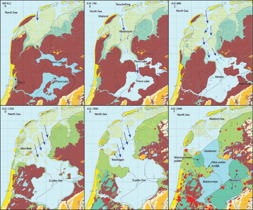
Fig. 3. Palaeogeographical development of the Zuyder Zee Region between 500 b.c. and a.d. 2000 (after Vos & De Vries Citation2013).
In the twelfth century, use of the name Almere was succeeded by that of the Zuyder Zee, referring to an accumulation of water with the characteristics of a sea. As a result, the water of the Zuyder Zee became brackish in the northern and western part, but remained fresh in the eastern and southern region for some centuries (Hogestijn Citation1992, pp. 107–9). The size of the land surface, in the basin, consisting of peat island areas and peat lagoon fringe areas, kept on decreasing with the passage of time due to floods, storms and dehydration. As a reaction and way of protection, dykes were built all along the shores of the Zuyder Zee from the twelfth century onwards. The oldest ones are estimated to have been constructed in the twelfth, thirteenth (both local) and fourteenth (regional) century (Hogestijn Citation1992, p. 110; Gerrets Citation2010, p. 37; Van den Biggelaar et al. Citation2014, p. 178). Habitation became limited to the relative safety of the boulder clay at Urk, along the east coast of the Schokland-area and along the north-eastern Zuyder Zee coast in the vicinity of Kuinre. The inhabitants of the Schokland-area were forced to leave their small terps in the fourteenth century, and to live on four major new terps (Emmeloord, Middelbuurt, Zuiderbuurt, and Zuidpunt) until the abandonment of Schokland in 1859. The Zuyder Zee reached a more or less stable size at approximately 1600 as is proven by comparing historical maps from that moment onwards.
spatial concentrations of medieval-age archaeology
The density analysis identified seven areas with a high density of archaeological material (, A–G). The areas A and B were well known before: they represent the still-persisting old settlements Kuinre (former lagoon rim) and Urk (a former island). Kuinre is nowadays a small and quiet town, but it played a remarkably important but hardly known role in Dutch history. The remnants of multiple castles, a sconce (fortification), the highest-known concentration of shipwrecks in the Zuyder Zee, and multiple written sources nonetheless testify to this past importance (see e.g. De Boer & Geurts Citation2002). The density of late medieval archaeological material on the island of Urk is modest when compared to the other find concentrations. A first hypothesis for this difference is the assumption that the late medieval (say eleventh- and twelfth-century) predecessor of the settlement Urk was positioned over 1 kilometre to the west of the current location of the town (Vreugdenhil Citation1999; Geurts Citation2005), in unreclaimed parts of the Zuyder Zee beyond our data coverage.
Fig. 4. Density map of medieval archaeological objects that were found in the Noordoostpolder. A = Kuinre, B = Urk, C = Schokland, D – G = drowned settlements.
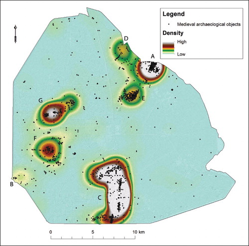
Concentration C corresponds closely to the contours of the later island Schokland. It is important to keep in mind that the toponym of ‘Schokland’ is post-medieval: it started circulating in the first half of the seventeenth century after the area had become isolated within the expanding Zuyder Zee (Vliet Citation1992, p. 6; Van Hezel & Pol Citation2008, p. 71). In our text we will use the term ‘Schokland area’ for 2,200–3,000 ha of middle- and high-density medieval archaeological finds, whereas we use ‘Schokland island’ to indicate the much smaller c. 115 ha that were left in early modern times after the Zuyder Zee erosion processes. After the reclamation of the Noordoostpolder and the cultivation of the new land, the traces of late medieval habitation were uncovered: the locations (shown by colour differences) of approximately 130 terps, ditches and multiple dykes were spotted on aerial photographs (UK Royal Air Force) made during the Second World War ().Footnote6
Fig. 5. Detailed archaeological landscape map of late medieval Schokland, framing the dozens of small dwelling mounds (terps) and dykes.
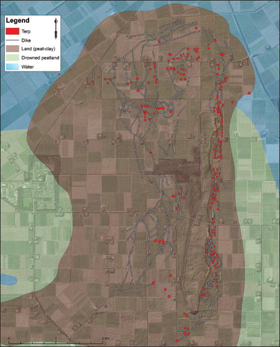
The other mapped find concentrations (D–G) represent high-density scatters of late medieval archaeological material only. There are no traces of terps, houses or dykes preserved here. Concentration D appears to overlap with that of the lost settlement Fenehusum as depicted on several sixteenth-century maps and mentioned in historical sources. Concentration E lies in the close vicinity of Kuinre and contains many late medieval pottery shards and animal bones. The concentrations F and G represent two more isolated locations in between the mainland in the north-east and the island Urk, where large amounts of pottery shards (dating from the twelfth until the fourteenth century), animal bones, bricks, and tuff stone have been found. The composition of the find assemblages and the sheer amount of archaeological finds in each of the clusters alone already is strong indication that locations A–G represent medieval settlements that were calved and drowned by the Zuyder Zee. It is important to find out whether there is historical evidence that might strengthen the archaeological assumptions.
historical settlement information
Multiple historical sources deliver evidence that the peatlands in the north-eastern part of the Zuyder Zee region were cultivated during the Middle Ages (see: Table 1). The process of exploitation, peat reclamation and inhabitation of the region started approximately in the eleventh century, although relatively little is known of this first phase of human influence in this landscape (Van Bavel Citation2010, p. 38). Several thirteenth– fifteenth-century documents from the abbey of St Odulphus near Stavoren (Frisia) do provide valuable information on the presence of medieval settlements in the research area. The charters contain a list of twenty-seven chapels and goods that belonged to the abbey, and it is this list that provides insights into the habitation of the northeastern Zuyder Zee region (Mol & Van Vliet Citation1998, p. 102; Mol Citation2011, p. 65). The list contains not only locatable settlements like Kunre (Kuinre), Urk (settlement) and Emelwerth (Emmeloord), but also the names of several settlements of which the locations are unknown.
When studying the lists of chapels it becomes clear that the list order in general matches a (clockwise) geographical order (). The route starts with the chapels that lie close to the east of the St Odulphus abbey: Laxnum (Laaksum), Wardelse (Warns) and Karnewald. The route then heads north and north-east, via Hindelepum (Hindeloopen), Gersmere (Gaastmeer), Heslum (Hieslum), Santforde (Sandfirden), Eddeghe (Idzega), Aldekerke (Oudega), Hagekerke (Heeg), Ipekeldekerke (Ypecolsga), and Wicle (Wijckel). It continues to the most southern tip of Frisia and across the border to the Province of Overijssel: Osterse (Oosterzee), Acthne (Echten), Scherpensele (Scherpenzeel), Kunre (Kuinre), Ruthne and Sillehem (IJsselham). Before the route continues to the island Urk and Emelwerth (Emmeloord), the names of Fenehusum, Kunresijl, Marcnesse and Nagele are mentioned, implying that they are positioned somewhere between Sillehem, Emelwerth and Urk. The route ends across the Zuyder Zee on the Frisian coast via Midlinge (Mirns) and Harch (Harich).
Fig. 6. Geographical representation of the list of chapels from the St Odulphus monastery of Stavoren.
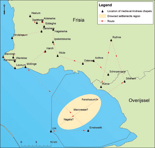
Based on the geographic order of the charter lists, a selection can be made of chapel-names that were (probably) positioned within the research area. Therefore, focus should be on the sequence from Kuinre until Emmeloord, including the names Fenehusum, Marcnesse, Nagele and Urk. There is no discussion about the location of the settlements Kuinre and Urk, as they still exist. The same is true for Emelwerth, although the settlement was abandoned in 1859 and only the remains are preserved (Van Hezel & Pol Citation2008, p. 199). Following the imaginary route of chapels on the charter lists, one would reach Fenehusum, Marcnesse and Nagele in between visiting Sillehem and Urk, leading right into the north-eastern Zuyder Zee region, although the exact locations of the settlement remain unknown. Further evidence of medieval habitation and cultivated lands comes from several historical maps (e.g. Christiaan Sgroten, c. 1570 and Provinces Unies des Pays Bas, 1648) that contain information on the remains of the medieval landscape in a retrospective way.
four-step late medieval palaeogeographical map series
With all the assembled archaeological, geological and historical information, a new four-piece palaeogeographical map series was made for the time span of a.d. 900–1600 (–). Approximately 45 per cent of the a.d. 1100 landscape of the Noordoostpolder area was reconstructed based on maritime and terrestrial archaeological findings, the other 55 per cent being areas outside major concentrations where continuity and the extent of land and water are based on interpreted geological data and historical sources. The 1400 map shows partial loss of this land, making use of the age-indications that archaeological data provided (site-distribution based: high-density areas in ). Our 1600 map (), historical maps from that period, Vos (Citation2015) and Kosian et al. (Citation2016) show that by 1600 the size of the Zuyder Zee was close to that of the nineteenth and early twentieth century.
Considering the Noordoostpolder highlighted area, peatland extent, as depicted on the new a.d. 900, 1100 and 1400 maps, is greater than that in earlier national palaeogeographical map series (a.d. 800 maps of Zagwijn Citation1986; Vos Citation2015). This is a result of including the archaeological find density analysis (see Methods). This evidence comes from relatively large areas that earlier reconstructions mapped as already eroded by that time. The map for a.d. 900 features several local-detail changes (compared to Vos & De Vries Citation2013; Vos Citation2015). The map depicts Urk and Schokland forming a peatland peninsula that is about to be breached by the expanding lagoon and to become cut off from the mainland (Vos & De Vries Citation2013 depict a breached situation). This is also notable in the lithological characteristics of the contemporary lagoon-floor deposits in the study area (Almere Bed) surrounding the peat peninsula: these show increased intercalations of sandy layering, indicating increased water movement (Wiggers Citation1955, p. 92; Ente et al. Citation1986, p. 130; Westerhoff et al. Citation2003b, p. 316; Gerrets Citation2010, p. 33). Surrounding peatland began to collect a cover layer of lagoon-derived clay owing to flooding during storms (often referred to as ‘clay deck’) from the ninth century onwards.Footnote7
According to our reconstruction, land surrounding Urk would have been separated from that around Schokland in the ninth or tenth century. Herein we reproduce the scenarios in Wiggers (Citation1955, p. 68) and Ten Anscher (Citation2012, p. 527), both leading back to the interpretation of the Codeen Profielenkaart (1947–1956) which depicts layers of young detritus gyttja between Urk and Schokland. It is also in accordance with Ente (Citation1973, p. 141) and Hogestijn (Citation1992, p. 110) who interpretatively date mainland detachment of Urk and Schokland to, respectively, the ninth and tenth century a.d. Schokland presumably separated from the mainland a little later than Urk, likely as a consequence of repeated storm surges in the eleventh or twelfth century (Ente et al. Citation1986, p. 132 and Cohen et al. Citation2009, p. 92 earlier entertained such reconstructions). The map for 1100 shows the peatland between Schokland and Kampen just breached.
Traces of late medieval habitation in the Noordoostpolder area are also depicted in the west of the Noordoostpolder (1100 and 1400 around Urk; 1100: further islands north of Urk) and in the north-eastern fringe (1100 and 1400 maps; peninsula in front of Kuinre). Adjacent to Urk the habitation is clearly late medieval (concentration F). Depicting peatland islands to the north of Urk on the map for 1100 (concentration G) corresponds to the mapping of Wiggers (Citation1955, p. 193, fig. 108) who presumed the area to be part of the larger island Urk, and that by Ten Anscher (Citation2012, p. 527) that has them separated by water. The find concentrations are from areas that by 1100 had a developed clay deck topping the peatland. While storms made the Zuyder Zee enlarge and eroded peatland rims, the same storms also caused flooding of peatland, depositing the clay deck (Wiggers Citation1955, p. 96; Hogestijn Citation1992, p. 98; Van den Biggelaar et al. Citation2014). It is plausible that the clayey topsoil proximal to the Zuyder Zee provided a better surface than peaty grounds some distance inland. Archaeological concentration G must have been an island in the period of approximately 1100–1300. The piece of land is considered lost to lagoon erosion on the maps of Zagwijn (Citation1986, a.d. 500–1200) and Vos and De Vries (Citation2013, a.d. 800), but when their maps of the Iron Age (Vos & De Vries) and the Roman Period (Zagwijn) are taken into account, the land becomes visible as a peninsula (Vos & De Vries) and an island (Zagwijn). It means that their maps depict the transformation of the Noordoostpolder landscape as happening somewhat too early (as mentioned earlier).
Clayey topsoil in the north-eastern part of Schokland (sourced from the rivers IJssel and Vecht, stirred up and deposited by the Zuyder Zee) must have been a very suitable surface for the medieval habitation in the northern part of Schokland, considering the high amount of medieval archaeological finds in this area. Population growth and a growth of trade in the Low Countries during the late Middle Ages resulted in the rapid extention of agriculture and land cultivation (e.g. Spek et al. Citation1996; Van Bavel Citation2010, p. 325). It is therefore likely that other parts of the Noordoostpolder region were cultivated as well, causing rapid compaction and erosion of the peat. Recent archaeological research in the remaining parts of the Kuinre peatland peninsula revealed remains of a late medieval (1300–1600) network of ditches, dug into peat as part of a reclamation (see ).Footnote8 Remains of the drowned late medieval settlement Fenehusen (which translates as ‘peat houses’) were found inside the ditches, making it plausible that people placed their houses directly on the peat, while reclaiming the peatlands.
The reconstruction of the IJssel and Vecht river mouths in the south of the map build on Ente et al. (Citation1986), Dirkx et al. (Citation1996), and Cohen et al. (Citation2009; Citation2012). Delivery of large volumes of sand and the build-out of the IJssel delta to the north of Kampen (underwater as well as above the water), commenced centuries later (peaking after 1200; e.g. Ente Citation1973; Van der Schrier Citation2004; Cohen et al. Citation2009) than the first delivery of fresh water (abundant well before 1200; e.g. Kooistra et al. Citation2006; Makaske et al. Citation2008; Cohen et al. Citation2012; Jansma et al. Citation2017). Therefore, in the maps for a.d. 900 and 1100 a still modest IJssel delta is depicted, aligned along easterly branches. The delta took its semi-circular shape with branches directed north-west in the centuries following that (Ente Citation1973, p. 153; Dirkx et al. Citation1996, p. 21; Cohen et al. Citation2009, pp. 90–2; Waldus Citation2018, ch. 11) — as seen in the maps for 1400 and 1600 (Kampereilanden: Isles of Kampen). Besides ample sand delivery by the fully established river to its delta, delta growth had become possible because of the enlargement of the water body in which the river ended. The IJssel delta can be considered land that replaced parts of the peat peninsula that existed in the a.d. 900 map. There are many more detailed conclusions to make, as is common when creating a new regional map series, but they should be made on a local scale.
landscape changes after 300 years of maritime development
The map of 1100 () depicts a landscape in which mankind had cultivated parts of the peatlands but was driven back by the water, most clearly illustrated by comparing it to the map of a .d. 900 (). It shows the region before the major and final erosion of the peatlands that started in the twelfth century and of which the results can be seen on the new map of 1400 (). The region was already populated, with habitation on individual house terps (Schokland- area), on the south-western part of the island Urk, on several islands north of Urk, on the natural heights of Urk and Vollenhove (boulder clay), on the peat peninsula to the north and west of Kuinre, and on the end of the peat peninsula (the future north-eastern shore). Historical documents further contribute to the understanding of the landscape by naming several chapels in the area: Kuinre, Kunresijl, Fenehusum, Marcnesse, Nagele, Emelwerth and Urk. It is not yet possible to connect all the names of the unknown chapels/ settlements to the multiple settlement locations as clear descriptions of their locations are lacking. The order of names in the Andreas charter does imply that Marcnesse and Nagele should be located somewhere in between the peat peninsula and the island Urk, for example on one of the islands close to Urk. The settlements Fenehusum and Kunresijl should be sought in the direct vicinity of Kuinre. For 1400, the amount of archaeological sites with a high density is limited to the coastal zone in the north-east, the Schokland-area and Urk. The other islands, a large part of the peninsula and the western shore of the Schokland-area were either drowned or completely washed away. Dykes were built along the coast, the Schokland-area and on Urk in order to withstand the floods (Van Hezel & Pol Citation2008). After 300 years of dynamic marine influence, nothing remained on the surface of the former islands, the peninsula and the Schokland-area except for some flats to the north of Urk (). Historical documents testify to heavy storm surges in 1163, 1164, 1170, 1173, 1196, 1214, 1219, 1220, 1221, 1246, and 1248 that terrorised the inhabitants of the Zuyder Zee region and demolished a large part of the peatlands (Buisman Citation1995, p. 361). We have not singled out a particular storm event to have caused the great majority of land loss (although some storms were more extreme than others; see Gottschalk Citation1971; Buisman Citation1995; Citation1996; Vos Citation2015). Repeated storm attacks lead to the eventual extent of the Zuyder Zee with peatland surviving at the island Schokland and along the eastern and southern fringes ().9 Multiple settlements (e.g. Marcnesse and Nagele) must have been drowned due to these floods and their names are not found in historical records from the fourteenth century onwards.
Fig. 7. Reconstruction of the north-eastern Zuyder Zee region for a.d. 900: peatland dominates, limited marine influence and land cultivation.
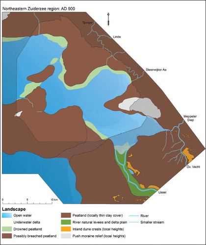
Fig. 8. Reconstruction of the north-eastern Zuyder Zee region for 1100: Zuyder Zee enlarged majorly, new routes, land cultivation and habitation.
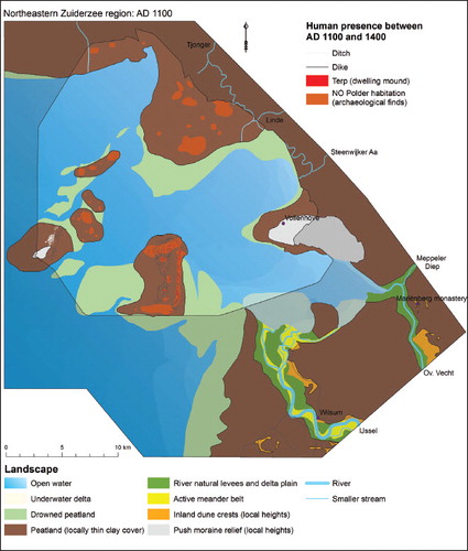
Fig. 9. Reconstruction of the north-eastern Zuyder Zee region for 1400: land loss, drowned settlements, harbour towns form.
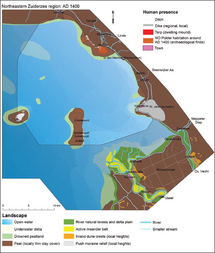
Fig. 10. Reconstruction of the north-eastern Zuyder Zee region for 1600: near-final size of Zuyder Zee reached, consolidation with dykes.
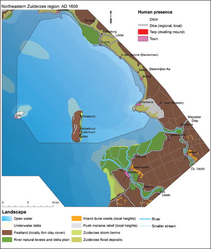
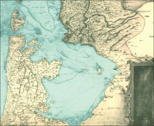
Fig. 11. Historical map of the Zuyder Zee region by Christian Sgroten (c. 1573), depicting the final stage of land erosion and the rise of the Zuyder Zee.
The people that once inhabited the region were forced to leave their settlements due to the many floods and resettled on the islands Urk, Schokland or further inland. This trans-placement towards the less-threatened parts of the region is clearly visible in the case of the medieval settlement Fenehusen, as depicted on a historical map from c. 1540 (). The first location of the settlement had already been overtaken by the Zuyder Zee and is depicted as a half-submerged building in the sea (blue circle), while the new location (same name) is shown to the north and close to the shore (red circle).
Fig. 12. Historical map of the Zuyder Zee region for c. 1540, depicting the drowned settlement Veenhuijzen in the northeastern part of the Zuyder Zee.
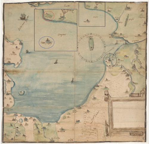
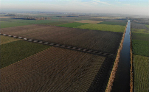
Plate I. Recent aerial photograph of the reclaimed north-eastern Zuyder Zee region.
From the thirteenth century onwards, dykes were constructed along the main coastal areas of the Zuyder Zee for protection against the raging floods of the sea (Van der Heide & Wiggers Citation1954; Van den Biggelaar et al. Citation2014). In the thirteenth to fourteenth century, in the wake of IJsseldelta expansion and the shortening of the distance to the open Zuyder Zee, Kampen established itself as a major harbor town. The 1400 map depicts two main branches (Noorderdiep and Zuyderdiep/ Brunneperdiep; cf. Waldus Citation2018) and marks with dashes a central third new branch (Rechte Diep) that was heavily engineered (if this branch was a natural one originally at all) to become the main entry to the town during the fifteenth century (historically evident, e.g. Tamse Citation1963; dendro-archaeologically evident: Waldus Citation2018).
CONCLUSION
We aimed to reconstruct the dynamic development of the landscape of the north-eastern Zuyder Zee region over late medieval times. The highly dynamic late medieval past of the area made it difficult to make this comprehensible, especially because of the coastal erosion that destroyed most of the time-relevant geological record, and the period lies beyond that from which historical maps become available. As marine erosion has caused the loss of most of the time-relevant geological record, this paper used an ‘archaeological data first’ approach — very much needed for the period 1100–1400 — whereby archaeological site distributions and spatial density analyses were combined. The order and priority that this information gets, and when complemented with information from geological observations, differs from the classical ‘geologyfirst’ palaeogeographical approach (working for mapping up to c. a.d. 900). This reconstruction approach allowed us to bridge a gap that otherwise existed for the late medieval period, allowing us to connect the series to the period coverage with historic maps, where palaeogeographical reconstruction data combination methods again switch order and priority (working onwards from c. 1600).
The ‘flipped’ approach proved to be successful in reconstructing the late medieval landscape of the study region as a four-step map series. The archeological data-incorporation methodology is however limited to the reconstruction for time periods when past habitation and recent surveying were both sufficiently dense. In the case of the Noordoostpolder, the archaeological evidence from before 1100 is insufficient. The priority of archaeological finds for the reconstructions does not mean that an exclusive archaeological (or geological) path should be chosen for the development of new map series: multidisciplinary data use is recommended.
The map of a.d. 900 still depicts large areas of peatland: that for 1100 depicts large islands and capes of peatland around an enlarged lagoon (origin of the Zuyder Zee), and that for 1400 considerable further land loss. The 1600 map depicts a fully cultivated landscape, with the Zuyder Zee greatly enlarged and its surviving peatland fringes embanked. Based on these new maps, several important conclusions can be made. First of all, the peatland areas between a.d. 900 and 1100 were far greater than depicted on earlier national palaeogeographical map series. Second, the Noordoostpolder region was relatively densely populated in the late Middle Ages. This is testified by the archaeological remains of drowned settlements and the multiple historical records that contain descriptions of the area and lists with (drowned) settlement names. Furthermore, nature can only partially be blamed for the land-loss catastrophes that it caused: much of the original medieval cultivated peat landscapes in late medieval times disappeared due to a combination of punctuated storm surge catastrophes, progressive lagoon rim calving and, especially, human interferences such as draining (ditch cutting) and ploughing. The latter made the lands more vulnerable to storms and floods. As a first reaction, people fled to the higher grounds of the islands and north-eastern shore and started to build small terps and dykes.
Although the Zuyder Zee drastically limited the habitation grounds and agricultural exploitation of the region, its development also opened up new maritime possibilities, as can be seen on the new map series, such as the development of harbours along the eastern shore and the IJssel River, and, through that, a better connection to other parts of the world.
We would recommend further exploration of the methodological issues concerning physicalgeographical and human-landscape impact, for example by comparing old and new reconstructions maps, asking the question whether the new reconstruction is solely based on more (archaeological) data or also on new visions of lagoon development and the human-induced development of peatlands. To conclude, our methods of palaeogeographical reconstruction provide a practicable concept that may be used outside the north-eastern quadrant of the Zuyder Zee too, and the map-series result provides a higher resolution backdrop for understanding late medieval developments in the quadrant: the land-loss history of the Zuyder Zee is no longer unknown.
acknowledgements
This work was supported by the Dutch Organization for Scientific Research (NWO; Ph.D.s in Humanities, file n. 322-60-006) and is part of the first author’s Ph.D. research (shortened, focused, journal peer-reviewed version of chapter 2 in Van Popta Citation2020). We thank editor Della Hooke and one anonymous reviewer for constructive comments on the Manuscript. We thank Prof. Van Holk and Prof. Raemaekers for constructive reviews of the thesis chapter manuscript.
Notes
1 This top of these deposits, often called ‘the Pleistocene sand’, is in most archaeological studies of the Noordoostpolder the deepest exposed layer. Pleistocene surfaces in the Noordoostpolder are generally covered by a few meters of Holocene deposits (with local exceptions). This is in contrast to areas surrounding the study areas to the north and east, where Holocene cover is mostly superficial.
2 This deepest bed of Holocene peat, where it is covered by substantial thickness of coastal plain deposits, is referred to as the Basal Peat (Basisveen-Laag; Westerhoff et al. Citation2003b, p. 351).
3 Pomponius Mela, Chorographia III, 24; Tacitus, Annales I, 60; Plinius Maior, Naturalis historiae IV, 101 (Gerrets Citation2010).
4 According to the work of Buisman (Citation1995, p. 361), the storm surges of 1163/64, 1170, 1173, 1196, 1214, 1219, 1220, 1221, 1246, and 1248 were responsible for the genesis of the Zuyder Zee. In most of the papers and articles on the former Zuyder Zee, the year of 1170 is used as the specific moment on which the Almere transformed into Zuyder Zee. See also: Gottschalk Citation1971, p. 30; Walsmit et al. Citation2009, p. 15.
5 New research by Van Popta (Citation2017) has identified many more smaller terps and dyke trajectories in the surroundings of Schokland than the 130 previously listed ones.
6 The start of the deposition of clay is based on C14 dates of top peat samples in the Schokland area (cal a.d. 770–940) and near the former north-eastern shore (see: Hogestijn Citation1992, p. 98; Van den Biggelaar et al. Citation2014, p. 186). The dates are very similar to those obtained in the Kampen area (Cohen et al. Citation2012: description onset ages of Gelderse IJssel, p. 50).
7 Van Popta – personal observation. Site excavated in 2017 (staff & students University of Groningen), documentation in prep.
8 Peat growth could have occurred on a local scale, the assumption is based on the whole region (see: Wiggers Citation1955, p. 95; Hogestijn Citation1992, p. 99).
Bibliography
- Bohncke, S. J. P., 1993. ‘Lateglacial environmental changes in the Netherlands: spatial and temporal patterns’, Quaternary Sci Rev, 12, pp. 707–18. doi: 10.1016/0277-3791(93)90008-A
- Borger, G. J., & Kluiving, S J., 2017. ‘The Wet Heart of the Netherlands’, in Interdisciplinarity Between Humanities and Science. A festschrift in honour of prof. dr. Henk Kars, ed. S. J. Kluiving, L. Kootker & R. Hermans (Leiden), pp. 37–54.
- Bos, I. J., 2010. ‘Distal delta-plain successions, Architecture and lithofacies of organics and lake fills in the Holocene Rhine-Meuse delta plain, The Netherlands’, unpubl Univ Utrecht Ph.D. thesis.
- Bosch, J. H. A., Cleveringa, P., & Meijer, T., 2000. ‘The Eemian stage in the Netherlands: history, character and new research’, Netherlands J Geosci, 79, pp. 135–45. doi: 10.1017/S0016774600021673
- Buitelaar, A. L. P., & Borger, G. J., 2015. ‘Landscape development and settlement history of the Vecht area (722–1122)’, Netherlands J Geosci, 94, pp. 375–85. doi: 10.1017/njg.2015.26
- Buisman, J., 1995. Duizend jaar weer, wind en water in de Lage Landen. Deel 1: tot 1300 (Franeker).
- Buisman, J., 1996. Duizend jaar weer, wind en water in de Lage Landen. Deel 2: 1300 tot 1450 (Franeker).
- Busschers, F. S., Kasse, C., van Balen, R.T., et al., 2007. ‘Late Pleistocene evolution of the Rhine-Meuse system in the southern North Sea basin: imprints of climate change, sea-level oscillation and glacioisostacy’, Quaternary Sci Rev, 26, pp. 3216–48. doi: 10.1016/j.quascirev.2007.07.013
- Busschers, F. S., Van Balen R. T., Cohen, K. M., et al., 2008. ‘Response of the Rhine-Meuse fluvial system to Saalian ice-sheet dynamics’, Boreas, 37, pp. 377–98. doi: 10.1111/j.1502-3885.2008.00025.x
- Cohen, K. M., Stouthamer, E., Hoek, W. Z., & Berendsen, H. J. A., et al., 2009. Zand in Banen - Zanddieptekaarten van het Rivierengebied en het IJsseldal in de provincies Gelderland en Overijssel (Arnhem).
- Cohen, K. M., Stouthamer, E., Pierik, H. J., & Geurts, A. H., 2012. Rhine-Meuse Delta Studies’ Digital Basemap for Delta Evolution and Palaeogeography (Utrecht).
- Cohen, K. M., 2017. Beschrijving gebiedsindeling en legenda kaartlaag T0123: Begraven Hoofdlandschappen en Landschapszones, Deltares rep 1210450-0014) (Utrecht).
- De Boer, P. C., & Geurts, A. J., 2002. Oude burchten in het nieuwe land. De middeleeuwse kastelen van Kuinre in de Noordoostpolder (Lelystad).
- De Bont, C., 2008. ‘Vergeten land: ontginning, bewoning en waterbeheer in de westnederlandse veengebieden (800-1350)’, Univ Wageningan Ph. D. thesis.
- De Haas, T., Pierik, H. J., Van der Spek, A. J. F., et al., 2017. ‘Holocene evolution of tidal systems in the Netherlands: effects of rivers, coastal boundary conditions, eco-engineering species, inherited relief and human interference’, Earth-Sci Rev, 177, pp. 139–63. doi: 10.1016/j.earscirev.2017.10.006
- De Mulder, E. F. J., & Bosch, J. H. A., 1982. ‘Holocene stratigraphy, radiocarbon datings and paleogeography of central and northern North-Holland (the Netherlands)’, Mededelingen Rijks Geologische Dienst, 36 (3), pp. 111–60.
- De Mulder, E. F. J., Geluk, M. C., Ritsema, I. L., & Weserhof, W. (eds), 2003. De ondergrond van Nederland (Groningen).
- Dirkx, G. H. P., Hommel, P. W. F. M., & Vervloet, J. A. J., 1996. Kampereiland: een wereld op de grens van zout en zoet (Utrecht).
- Edelman, T., 1974. Bijdrage tot de historische geografie van de Nederlandse kuststreek (The Hague).
- Ente, P. J., 1973. ‘De IJsseldelta, Kamper Almanak 1973–1974, pp. 137–64.
- Ente, P. J., Koning, J., & Koopstra, R., 1986. Flevobericht nr. 258. De bodem van Oostelijk Flevoland (Lelystad).
- Gerrets, D. A., 2010. ‘Op de grens van land en water. Dynamiek van landschap en samenleving in Frisia gedurende de Romeinse Tijd en de Volksverhuizingstijd’, Groningen Archaeol Stud 13, Univ Groningen Ph.D. thesis (Groningen).
- Geurts, A. J., 1991. Schokland: de historie van een weerbarstig eiland (Zutphen).
- Geurts, A. J., 2005. Urk. De geschiedenis van een eiland (Lelystad).
- Gotjé, W., 1993. ‘De Holocene laagveenontwikkeling in de randzone van de Nederlandse kustvlakte (Noordoostpolder)’, unpubl Univ Amsterdam Ph.D. thesis.
- Gottschalk, M. K. E., 1971. Stormvloeden en rivieroverstromingen in Nederland. Deel 1: De periode vóór 1400 (Assen).
- Groothedde, M., 2010. ‘De “nieuwe” IJssel. Wat vertellen de historische bronnen en archeologische vondsten’, Bijdragen en Mededelingen Gelre, 101, pp. 7–26.
- Hoek, W. Z., 2000. ‘Abiotic landscape and vegetation patterns in the Netherlands during the Weichselian Late Glacial’, Netherlands J Geosci, 79 (4), pp. 497–509. doi: 10.1017/S0016774600021983
- Hogestijn, J. W. H., 1992. ‘Schokland in de late middeleeuwen’, Schokland Revisited. Cultuur Historisch Jaarboek voor Flevoland, 2, pp. 95–112.
- Jansma, E., Van Lanen, R. J., & Pierik, H. J., 2017. ‘Travelling through a river delta: a landscape-archaeological reconstruction of river development and long-distance connections in the Netherlands during the first millennium’, Medieval Settlement Res, 32, pp. 35–9.
- Kasse, C., 2002. ‘Sandy aeolian deposits and environments and their relation to climate during the Last Glacial Maximum and Lateglacial in northwest and central Europe’, Progress in Physical Geogr, 26 (4), pp. 507–32. doi: 10.1191/0309133302pp350ra
- Kluiving, S. J., Rappol, M., & Van der Wateren, D., 1991. ‘Till stratigraphy and ice movements in eastern Overijssel, the Netherlands’, Boreas, 20 (3), pp. 193–205. doi: 10.1111/j.1502-3885.1991.tb00150.x
- Kok, M. S. M., 2008. ‘The homecoming of religious practice: an analysis of offering sites in the wet lowlying parts of the landscape in the Oer-IJ area (2500 BC – AD 450)’, unpubl Univ Amsterdam Ph.D. thesis.
- Kooistra, M. J., Kooistra, L. I., Van Rijn, P., & Sass-Klaassen, U., 2006. ‘Woodlands of the past. The excavation of wetland woods at Zwolle-Stadshagen (the Netherlands): Reconstruction of the wetland wood in its environmental context’, Netherlands J Geosci, 85 (1), pp. 37–60. doi: 10.1017/S0016774600021417
- Kosian, M. C., Van Lanen, R J., & Weerts, H J. T., 2016. Een nieuwe kaart van Nederland in 1575 (Amersfoort).
- Koster, K., Stafleu, J., & Cohen, K. M., 2017. ‘Generic 3D interpolation of Holocene base-level rise and provision of accommodation space, developed for the Netherlands coastal plain and infilled palaeovalleys’, Basin Res, 29 (6), pp. 775–97. doi: 10.1111/bre.12202
- Lenselink, G., & Koopstra, R., 1994. ‘Ontwikkeling in het Zuiderzeegebied; van Meer Flevo, via de Almerelagune, tot Zuiderzee’, in In de Bodem van Noord-Holland, ed. M. Rappol & C. M. Soonius (Amsterdam), pp. 129–40.
- Makaske, B., Maas, G. J., & Van Smeerdijk, D. G., 2008. ‘The age and origin of the Gelderse IJssel’, Netherlands J Geosci, 87 (4), pp. 323–37. doi: 10.1017/S0016774600023386
- Menke, U., Van de Laar, E., & Lenselink, G., 1998. Flevobericht nr. 415. De geologie en bodem van Zuidelijk Flevoland (Lelystad).
- Mol., J. A., & Van Vliet, K., 1998. ‘De oudste oorkonden van het Sint-Odulfusklooster van Staveren’, Jaarboek voor Middeleeuwse Geschiedenis, 1, pp. 73–134.
- Mol, J. A., 2011. ‘De middeleeuwse veenontginningen in Noordwest-Overijssel en Zuid-Friesland: datering en fasering’, Jaarboek voor Middeleeuwse Geschiedenis, 14, pp. 46–90.
- Peeters, J., Busschers, F. S., Stouthamer, E., et al., 2016. ‘Sedimentary architecture and chronostratigraphy of a late Quaternary incised-valley fill: a case study of the late Middle and Late Pleistocene Rhine system in the Netherlands’, Quaternary Sci Rev, 131, pp. 211–36. doi: 10.1016/j.quascirev.2015.10.015
- Pierik, H. J., Cohen, K. M., Vos, P. C., et al., 2017. ‘Late Holocene coastal-plain evolution of the Netherlands: the role of natural preconditions in human-induced sea ingressions’, Proc Geologists’ Assoc, 128 (2), pp. 180–97. doi: 10.1016/j.pgeola.2016.12.002
- Pierik, H. J., 2017. ‘Past human-landscape interactions in the Netherlands: Reconstructions from sand belt to coastal-delta plain for the first millennium AD’, unpubl Univ Utrecht Ph.D. thesis.
- Pons, L. J., & Wiggers, A. J., 1959/1960. De holocene wordingsgeschiedenis van Noord-Holland en het Zuiderzeegebied (Wageningen).
- Pons, L. J., Jelgersma, S., Wiggers, A. J., & De Jong, J. D., 1963. ‘Evolution of The Netherlands coastal area during the Holocene’, in Verhandelingen van het Koninklijk Nederlandsch Geologisch-Mijnbouwkundig Genootschap, pp. 197–207.
- Rensink, E., Weerts, H. J. T., Kosian, M., Feiken, H., et al., 2016. Archeologische Landschappenkaart van Nederland, Versie 2.6 (Amersfoort).
- Roep, T. B., & Van Regteren Altena, J. F., 1988. ‘Paleotidal levels in tidal sediments (2800-3635 BP): compaction, sea level rise and human occupation (3275-2620 BP) at Bovenkarspel, NW Netherlands’, in Tide-Influenced Sedimentary Environments and Facies, ed. P. L. de Boer, A. van Gelderen & S. D. Nio (Dordrecht), pp. 215–31.
- Schokker, J., Weerts, H. J. T., Westerhoff, W. E., et al., 2007. ‘Introduction of the Boxtel Formation and implications for the Quaternary lithostratigraphy of the Netherlands’, Netherlands J Geosci, 86 (3), pp. 197–210. doi: 10.1017/S0016774600077805
- Spek, M., Zeiler, F. D., & Raap, E., 1996. Van de Hunnepe tot de zee; de geschiedenis van het Waterschap Salland (Kampen).
- Tamse, C. A., 1963. ‘Bijdrage tot de economische geschiedenis van Kampen in de Middeleeuwen en de XVIe eeuw, Kamper Almanak 8, pp. 204–79.
- Ten Anscher, T. J., 2012. ‘Leven met de Vecht: Schokland-P14 en de Noordoostpolder in het neolithicum en de bronstijd’, Univ Amsterdam Ph.D. thesis (Amsterdam).
- Ter Wee, M. W., 1962. ‘The Saalien Glaciation in the Netherlands’, Mededelingen Rijks Geologische Stichting, 15, pp. 57–76.
- Van Bavel, B., 2010. Manors and Markets. Economy and society in the Low Countries, 500–1600 (Oxford).
- Van Beek, R., 2009. ‘Reliëf in Tijd en Ruimte. Interdisciplinair onderzoek naar bewoning en landschap van Oost-Nederland tussen vroege prehistorie en middeleeuwen’, Univ Wageningen Ph. D. thesis (Wageningen).
- Van den Biggelaar, D. F. A. M., Kluiving, S. J., Van Balen, R. T., et al., 2014. ‘Storms in a lagoon: flooding history during the last 1200 years derived from geological and historical archives of Schokland (Noordoostpolder, The Netherlands)’, Netherlands J Geosci, 93, pp. 175–96. doi: 10.1017/njg.2014.14
- Van der Hammen, T., 1951. ‘Late-Glacial flora and periglacial phenomena in the Netherlands’, unpubl Univ Leiden Ph. D. Thesis.
- Van der Heide, G. D., 1951. ‘Archaeologisch-geologisch onderzoek in de voormalige Zuiderzee’, Grondboor & Hamer, 11.2, pp. 187–92.
- Van der Heide, G. D., 1965. Van landijs tot polderland. Tweeduizend eeuwen Zuiderzeegebied (Amsterdam).
- Van der Heide, G. D., & Wiggers, A. J., 1954. ‘Enkele resultaten van het geologische en archaeologische onderzoek betreffende het eiland Schokland en zijn naaste omgeving’, Langs gewonnen velden, pp. 96–113.
- Van der Schrier, D. M., 2004. ‘Wanneer de IJssel een Rijntak werd en hoe het meer Flevo afwaterde’, Westerheem, 53, pp. 182–89.
- Van Hezel, G., & Pol, A., 2008. Leven met water. Schokland en omgeving (Utrecht).
- Van Huissteden, J., Vandenberghe, J., & Van Geel, B., 1986. ‘Late Pleistocene stratigraphy and fluvial history of the Dinkel Basin (Twente Eastern Netherlands)’, Eiszeitalter und Gegenwart, 36, pp. 43–59.
- Van Popta, Y. T., 2016. ‘Taken by the sea. New analyses on the dynamic past of the maritime cultural landscape known as the former Zuiderzee (the Netherlands)’, Cambridge Archaeol Rev, 31.2, pp. 75–90.
- Van Popta, Y. T., 2017. ‘Opgespoorde sporen van bewoning. Een archeohistorische en geografische interpretatie van het laatmiddeleeuwse landschap van de Noordoostpolder’, Tijdschrift voor Historische Geografie, 2.3, pp. 130–43.
- Van Popta, Y. T., & Aalbersberg, G., 2016. ‘Onbekend maar niet onbemind: terpen en terponderzoek in de Noordoostpolder’, in Van Wierhuizen tot Achlum. Honderd jaar archeologisch onderzoek in terpen en wierden, ed. A. Nieuwhof (Groningen), pp. 129–40.
- Van Popta, Y. T., & Van Holk, A. F. L., 2018. ‘Where are the shipwrecks of the Zuiderzee? A new version of the Shipwreck Database Flevoland (3.0), based on spatial and archaeohistorical research concerning wreck sites in the province of Flevoland’, Palaeohistoria, 59/60, pp. 191–228. doi: 10.21827/5beab08b4d742
- Van Popta, Y. T., 2020. ‘When the shore becomes the sea. New maritime archaeological insights on the dynamic development of the northeastern Zuiderzee region (AD 1100–1400), the Netherlands’, unpubl Univ Groningen Ph.D. thesis.
- Van Zijverden, W. K., 2017. ‘After the Deluge. A palaeogeographical reconstruction of Bronze Age West-Frisia (2000–800 BC)’, unpubl Univ Leiden Ph.D. thesis.
- Vliet, E. G., 1992. ‘Schokland en Kampen’, Het Schokker Erf, 19, pp. 1–7.
- Vos, P. C., 2008. ‘The geological development of the OerIJ area’, in The Homecoming of Religious Practice: an analysis of offering sites in the wet lowlying parts of the landscape in the OerIJ area, ed. M. S. M. Kok (Amsterdam), pp. 81–95.
- Vos, P. C., 2015. ‘Origin of the Dutch Coastal Landscape. Long-term landscape evolution of the Netherlands during the Holocene, described and visualized in national, regional and local palaeogeographical map series, Univ Utrecht Ph.D. thesis (Utrecht).
- Vos, P. C., & De Vries, S., 2013. 2e generatie palaeogeografische kaarten van Nederland (2nd edn) (Utrecht).
- Vos, P. C., De Koning, J., & Van Eerden, R., 2015. ‘Landscape history of the Oer-IJ tidal system, Noord-Holland (the Netherlands)’, Netherlands J Geosci, 94 (4), pp. 295–332. doi: 10.1017/njg.2015.27
- Vreugdenhil, V., 1999. ‘Het verdronken land van Urk’, Historisch Geografisch Tijdschrift, 17, pp. 15–24.
- Waldus, W., ed. 2018. De opgraving en lichting van de 15e-eeuwse IJsselkogge (Utrecht).
- Walsmit, E. H., Kloosterboer, H., Persson, N., & Ostermann, R., 2009. Spiegel van de Zuiderzee: geschiedenis en cartobibliografie van de Zuyder Zee en het Hollandse Waddengebied (Houten).
- Westerhoff, W. E., Geluk, M. C., & De Mulder, E. F. J., 2003a. ‘Deel 2. Geschiedenis van de ondergrond’, in De ondergrond van Nederland, ed. E. F. J. De Mulder, M. C. Geluk, I. L. Ritsema, et al., pp. 119–246.
- Westerhoff, W. E., Wong T. E., & De Mulder, E. F. J., 2003b. ‘Deel 3. Opbouw van de ondergrond’, in De ondergrond van Nederland, ed. E. F. J. De Mulder, M. C. Geluk, I. L. Ritsema, et al., pp. 247–373.
- Wiggers, A. J., 1955. De wording van het Noordoostpoldergebied. Een onderzoek naar de physisch-geografische ontwikkeling van een sedimentair gebied (Zwolle).
- Zagwijn, W. H., 1983. ‘Sea-level changes in the Netherlands during the Eemian’, Geologie en Mijnbouw, 62 (3), pp. 437–50.
- Zagwijn, W. H., 1986. Geologie van Nederland, Deel 1. Nederland in het Holoceen (Haarlem).
- Zagwijn, W. H., 1989. ‘Vegetation and climate during warmer intervals in the Late Pleistocene of western and central Europe, Quaternary Int, 3 (4), pp. 57–67. doi: 10.1016/1040-6182(89)90074-8