
ABSTRACT
It is very difficult to obtain absolute historical datings of road features found at archaeological excavations. Nevertheless, various physical dating methods have been developed for this purpose, including Optical Stimulated Luminescence (OSL). After a small-scale archaeological campaign, samples from a medieval trading route in the Veluwe area (central Netherlands) on sandy soils have been dated with OSL, in order to compare these with archaeological and historical data of the same route. The absolute datings of tracks of this so-called Harderwijkerweg appeared to correspond largely with the archaeological interpretations and historical sources (datings between the thirteenth and seventeenth centuries). The soil profiles also revealed new insights into the diachronical development of the excavated tracks. It was concluded that the combination of archaeological excavation, OSL dating and historical archive research could be a reliable method for the dating and contextualisation of historical roads on Pleistocene sandy soils.
INTRODUCTION
THE LANDSCAPE SETTING
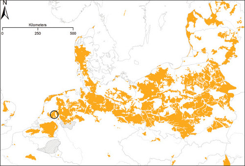
The North-western European Sand Belt stretches from northern Belgium via the Netherlands, northern Germany, western Jutland towards northern Poland (). It is a 50–200 km-wide belt of glacial moraines, fluvioglacial deposits and periglacial coversands, largely dating from the last three glacials and interglacials (350,000– 11,700 B.P.) (Zeeberg Citation1998; Jones et al. Citation2005; Koster Citation2009). These predominantly light sandy soils have been favourable settlement areas since early prehistoric times and thus, were densely populated from the Paleolithic deep into early historic times (Behre Citation2008). This, however, changed in the High Middle Ages when the main settlement areas shifted towards newly reclaimed coastal plains and river valleys, and as a consequence the sandy landscapes changed towards rather loosely populated and marginal heathland farming systems (Spek Citation2007). Nowadays these sandy landscapes still show low population densities and have a relatively high coverage of forest plantations and heathlands.
Fig. 1. Geographical distribution of The North-west European Sand Belt and location of the research area of The Veluwe within this belt.
Because of their millennia-old settlement history and low-intensive land use these landscapes show relatively good conservation conditions for anthropogenic remains, like deserted settlements, Bronze Age barrows and urnfields, prehistoric field systems, and, especially, historical infrastructure. Hidden in the forests and heathlands of the North-western European Sand Belt extensive net-works of historical road systems can be detected (Van Lanen Citation2017; Vletter & Van Lanen Citation2018).
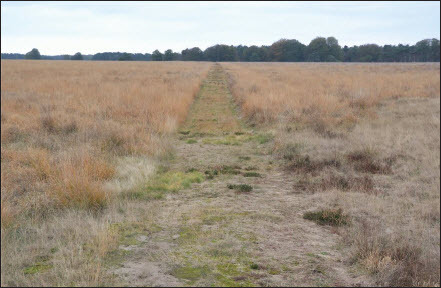
Compared to roads and routes in the adjacent peat, clay and loess areas these sandy roads show some specific characteristics. Imprints of cart and wagon tracks remain visible for many decades or even centuries after they were formed, because of the rather stable sandy soil matrix and their fixation by low-growing vegetation such as semi-natural grassland, heathland vegetation or forest undergrowth. However, individual wheel tracks of a road on sandy soils show a rather quick turnover rate, as they quickly deepen and become loosened by wind and water erosion. Therefore, travellers regularly constructed a new cart or wagon track next to the old ones. Because the majority of these road systems developed in very open heathland vegetation in the past and were situated on rather stable dry soils there was hardly any limit to the lateral extension of road bundles. Over the decades and centuries this resulted into bundles of cart and wagon tracks, stretching up from several metres to sometimes 500–1,000 metres in width (). Together these tracks tell the stories of the age-long local, regional and intraregional traffic of people and goods. Therefore, these tracks are a very challenging object for historical research as well as an important category of our common European cultural heritage.
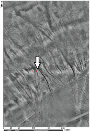
Fig. 2. Visualisation with airborne laser scanning data of historical cart tracks east of Oud-Reemst (Hoge Veluwe National Park, The Netherlands), visualization .In red, the outline of trial trench in the bundle of car tracks. Also indicated with the white arrow.
The Hoge Veluwe National Park in the Veluwe region (Central Netherlands) contains a high number of historical road tracks from various periods. Therefore, this park was selected for our pilot project on archaeological research and OSL dating of sandy road tracks in 2015. The aim of this project was to test the combination of archaeological excavation of road features, OSL dating and contextual research of historical maps and archives for unraveling the age and history of a medieval trade route. The project is part of a more extensive Ph.D. research by the first author, aimed at the detection, dating, reconstruction and interpretation of historical road systems with Airborne Laser Scanning (ALS) (Vletter Citation2020).
STATE OF RESEARCH
The dating of prehistoric and historical roads is a topic that has received less attention in European research so far. As a result specific literature is scarce (Bailey Citation2019; Bekker-Nielsen 2004; Denecke Citation2007; Vletter Citation2015; Smith Citation2011; Zakrzewski et al. Citation2015). In general, two main types of dating exist in landscape history: i.e. absolute dating and relative dating. In absolute dating geophysical data are investigated in laboratories to provide an exact date with margins (Ellis Citation1998; McCann Citation2003; McIntosh & Catanzariti Citation2006; Linford Citation2007) Ideally, these data can be linked to historically documented events, processes or landscape features. Absolute dating projects for roads has been limited so far and often only carried out for prehistoric wooden roads (Brindley & Lantink Citation1998; Casparie & Stevens Citation2001; Van der Sanden Citation2002).
Relative dating provides a classification of the age between (archaeological) features, indicating which one is younger (older) than the other, without knowing an exact date. Archaeological finds, historical structures, maps, and physical intersection are means to carry out relative dating (Vletter & Schloen 2015).
PROBLEM DEFINITION
For a thorough understanding of fossil roads in sandy soils it is important to take note of the fact that these roads always consist of various wheel tracks, as tracks wear out in the course of time and become too loose for efficient transport. That is the moment that a cart driver would choose to make a new and fresh track next to the old track. From the moment that a wheel track becomes deserted in favour of a new track next to it, the old track becomes more or less fossilised. Whereas the original road clearly showed a U-shape with the two separate wheel tracks of the former carts, lateral wind and water erosion gradually caused an infilling of these tracks, with a V-shaped fossilised cart track as a final result. These V-shaped tracks can be detected in the field, but also on aerial photographs or airborne laser scans. Until recently, the mapping of these fossilised tracks with the help of aerial photographs was seriously hampered by forest vegetation, which is very abundant in the sandy landscapes of the Northwestern European Sand Belt. However, with the help of modern Airborne Laser Scan (ALS) data it has become possible to make highly detailed maps of the various road systems.
Now that the detection and mapping of fossilised roads is becoming more and more feasible, the historical interpretation and contextualisation of the roads detected is one of the next problems that turns up, as well as the relative and absolute dating of individual cart tracks and road systems as a whole. How could we date exactly an individual wheel track in a road system that does not provide any organic matter suitable for radiocarbon dating? How can we reconstruct the origin and long-term development of the road system as a whole, consisting of dozens of different wheel tracks? What has been the historic trajectory and function of a particular road system? And how was this trajectory being determined by the various characteristics of the historic landscape, such as height differences, soil structure, wetness, and the location of existing settlements? These are the central questions that will be discussed in this paper.
OBJECT OF STUDY: THE VELUWE REGION AND ITS HISTORICAL ROAD SYSTEMS
The landscape
The Veluwe is a region of moraine ridges and meltwater sands in the central Netherlands of approximately 1000 km2 (). Its geological backbone was formed during the Saalian Ice Age (230,000–130,000 BP) when glaciers formed a series of ice-pushed ridges 50–100 metres above sea level. Subsequently fluvioglacial sediments, periglacial sands and aeolian coversands filled up the glacial basins in between these moraines, resulting in an undulating region with predominantly coarse sandy soils. In prehistoric and early historic times, the elevated moraine ridges were favourite sites for settlements. As a consequence, local and intraregional sandy roads of those days were mainly situated in these elevated areas. Already in the Middle Bronze Age there must have been an extensive network of regional roads, seeing the long chains of burial mounds of this era which stretched along very straight lines (Bourgeois Citation2012).
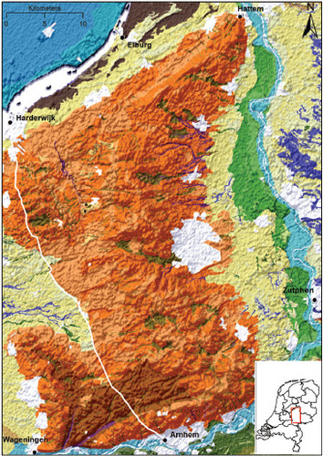
Fig. 3. Section of the archaeological landscape map of the Netherlands (1:50,000) depicting the Veluwe region and the trajectory of the medieval trade route of the Harderwijkerweg. Clearly visible are the characterising ice-pushed moraines in this area (light and dark orange sections). For a detailed description of the individual landscape units, legend and background information see Rensink et al. (2017).
Historical road systems
Between the ninth and fourteen centuries a.d. many new settlements were created in the lowlands around the Veluwe Massive, such as in the Guelders valley in the west, the Zuiderzee region in the north, the IJssele-valley in the east, and the Rhine valley in the south. Pre-medieval settlements on the higher moraine ridges founded younger daughter settlements in these valleys. The new lowland villages were mutually connected by a series of new roads on the lower outer slopes of the Veluwe. Connections between the daughter and mother settlements were created by a series of uphill and downhill roads. The lowland zones around the Veluwe were also the areas where new medieval market towns were developed by the Dukes of Guelders, such as Zutphen, Arnhem, Wageningen, Harderwijk, Elburg, and Hattem. They were mutually connected by a regional late medieval trade road system crisscross over the Veluwe Massive and passing numerous old villages, hamlets and solitary farms. One of these was the Harderwijkerweg, the medieval and early modern trade road between the flourishing late medieval market towns of Harderwijk in the north and Arnhem in the south ().
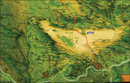
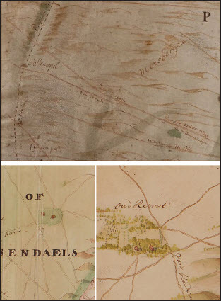
Fig. 4. The historical map of the Veluwe Quarter by Christiaan sGrooten from the year 1570 shows a large part of the Harderwijkerweg. Only in the northern part did the map differ from later maps.
This settlement-oriented medieval road pattern was quite different from the new intraregional road systems of the so-called Hessenwegen (‘Hessian roads’), roads that were developed in the Early Modern Period to permit quick long-distance merchant traffic between German towns in the east and the Golden Age towns of Holland (western Netherlands) in the late sixteenth and seventeenth century a.d. (Pieko Citation1993). These new trade routes had a broader wheel gauge than the previous ordinary roads, which resulted in a separate road network that avoided the existing medieval roads as well as the villages on these roads (). They were mainly constructed in remote heathland landscapes, which stimulated the building of several important inns.
Plate I. In the seventeenth century the trade route network of the so-called Hessenwegen (Hessian roads) was constructed. It functioned independently from the medieval village road systems and therefore mainly passed uninhabitated heathland and forest areas.
Another interesting intraregional road network of the Veluwe was the royal hunting road network that was constructed at the Veluwe in the late seventeenth century under the authority of King William iii of Holland and England. Based on his royal palace of De Loo at Apeldoorn as a starting point, he ordered to the building a series of very straight roads through forests and heathlands to his various hunting lodges on other sides of the Veluwe (). This road system was used for the so-called ‘par force hunting’ by the king and his international relations (Leyden Citation1940; Van Heijgen Citation2015; Bijster & Spek Citation2019).
Plate II. Straight seventeenth-century hunting road of King William III at the Hoge Veluwe National Park.
The fieldwork area
In the Dutch National Park De Hoge Veluwe a heathland area was selected which contained numerous fossil road tracks. This study area is situated on the push moraine of Oud Reemst, the soils of which mainly consist of coarse sandy and gravelly brown podzolic soils (Dutch: holtpodzol; soil code Y30), locally alternated with more fine coversands. The groundwater level is about 80 cm below ground level.
Until 1900, the heathlands and woodlands around the small hamlet of Oud Reemst were managed as commons by local farmers (). The heathlands, especially, were crucial for farmers. Intensive sheep grazing and the extraction of sods for littering the stables resulted in a strong degeneration of both the vegetation and soil over the ages. Around the village, wooded embankments were constructed in order to protect the farmyards and arable fields.
Fig. 5. Topographical map of 1900 of the hamlet of Oud-Reemst. The small farms (red) are surrounded by arable fields (white), woodlands (dark green), heathlands (pink) and sand blowings (grey).
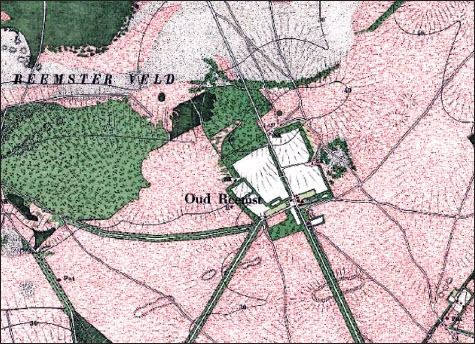
The hamlet of Oud Reemst has been an intermediate station on the long-distance trading route between Arnhem and Harderwijk since the thirteenth century. As a result, the surroundings of this settlement are swarming with historical road tracks. Besides the important regional and international trade routes, a lot of local roads are visible, generated over the centuries by sheep drifts and local cart transport. Remains of them can be found in forests, sand-blown areas and heathlands. Due to international changes, sheep breeding deteriorated and this pushed farmers into privatising large parts of the heathland and selling them. New farms were built on the new developed estates. Further, wooden hedges of oak coppices were laid out around the new properties. The estate owners straightened roads or built new ones. The rest of the property was parceled out in straight blocks and planted mainly with deciduous and conifer trees.
RESEARCH AIMS
This paper concentrates on the following four research aims:
The mapping of historical road systems of the Veluwe region with the help of Airborne Laser Scanning (ALS);
The reconstruction and historic contextualisation of the late medieval and early modern trade route and roads of the Harderwijkerweg historic background of this historic road systems (origin, selection of routing, function, long-term development, relics);
Archaeological excavation of several wheel tracks of the Harderwijkerweg;
Absolute dating of these excavated wheel tracks and the interrelated soil stratigraphy.
The methods that are used in these studies will be discussed in the following paragraphs.
METHODOLOGY
The historical roads have been visualised with the elaboration of Airborne Laser Scan (ALS) data. Many road tracks are distinguishable on the visualisation. However, the dating of the roads is not possible based on the basis of their outlook or intersections. Indeed, fieldwork is necessary to shed more light on their age. Therefore, a trial trench trial was dug which was planned to provide information about the physical structure, the genesis and age of a road in the Veluwe. More precisely the morphometric characteristics and stratigraphic position will be investigated, providing insight in the formation process of road traces and their post-depositional process when the road became out of use. The outcome will be compared with the OSL dating, historical sources, maps, and archaeological findings.
VISUALISATION THROUGH AIRBORNE LASER SCAN (ALS)
Airborne Laser Scan (ALS) is a technique in which from an airborne platform laser pulses are sent to the earth surface. Subsequently, a digital terrain model (DTM) is created from the returning pulses of the earth surface. Visualisation techniques can make micro-relief visible from this DTM, which is not visible with the naked eye in the field. This high-detail visibility, together with the possible large area coverage, constitutes the power of ALS for historical landscape research (Opitz & Cowley Citation2013; Doneus & Briese Citation2010; Vletter Citation2015).
Vegetated areas are most apposite for ALS. They contain more historical micro-relief than cultivated agricultural land (Doneus & Briese Citation2010; Vletter Citation2015). The Veluwe exists largely of forest and heathland and is therefore suitable for ALS. Indeed, many historical traces are present here. The openness technique (Yokoyama et al. Citation2002) was used to visualise the roads and paths in the Veluwe. This visualisation technique is suited for a follow-up extraction step (Kokalj & Hesse Citation2017). The Feature Analyst tool has been used for this extraction step and has led to a high-density map with roads from different periods (Vletter & Van Lanen Citation2018).
DESK RESEARCH
The first part of the research will be a desk research. A contextualisation of the Harderwijkerweg is presented, based on archaeological reports, historical documents, historical maps, results of earlier research, and visualisation in geographical information system (GIS).
ARCHAEOLOGICAL EXCAVATION
An archaeological fieldwork project was prepared according to Dutch law by writing a research programme, getting permits from the official institutes and arrangement of the necessary equipment. The preparation also included the study of geophysical characteristics. The same accounted for the recognition of the historical geographical characteristics for the area. This information together with earlier findings led to an archaeological expectation of the excavation on 7 and 8 April 2014. Based on the visualisation in GIS an area was selected in order to carry out excavation. The precise location near Oud Reemst was chosen because of its clear visibility in the field. Before the excavation, the location had to be checked for explosives from the Second World War with a metal detector. One test pit, 6 metres long and 0.5 metres wide, was planned to run across a track in order to increase the probability of findimg traces. The test pit was to be excavated with a spade to expose the (subtile) layers. Further material was prepared for possible C14, botanic or OSL dating. A notebook, drawing table, a camera, and GPS measurements was foreseen as necessary to document the excavation visually and verbally in a final excavation report and in a geographic information system (GIS).
OLS DATING
Absolute dating and relative dating are the two branches of dating. With relative dating, it is determined whether a certain road is older or younger than another one. Written sources, physical intersection and historical maps can provide input to sort out the relative age. For example, building documents can help to provide information of former natural roads. Further, substantial archeological finds can give an indication for the period of use of a road or path. For natural roads, without such archaeological finds, we have to make use of other techniques to establish an absolute date or period of use. Optical Stimulated Luminescence dating is often the only technique applicable for this scope (Vletter & Schloen Citation2017). Therefore, this technique can be applied to the route under investigation — the Harderwijkerweg.
Optimal Luminescence dating is based on two measurements. A first measurement calculates the radiation received by a sample during its exposure to sunlight or intense heat (the zeroing event). A second measurement quantifies the accumulated luminescence signal after the last exposure to sunlight of the sample. The accumulated luminescence, caused by ionising radiation and cosmic rays, is stored as radiation. Stimulation evicts this stored radiation. Luminescence will be released and measured. The last depositional event can be calculated by combining the two measurements. Quart and potassium feldspar are normally the minerals used for OSL dating (USGS 2015).
Additional to indirect dating based on contextual information of relics in archaeological excavations or mentions in historical archives, Optical Stimulated Luminescence (OSL) is the only possible absolute dating technique so far available for roads in natural soil materials, when soil conditions are good and post-processual dynamics are low. The outcome of the OLS dating is compared with historical sources and the stratigraphic interpretation of the excavation.
RECONSTRUCTION AND HISTORICAL INTERPRETATION OF THE HARDERWIJKERWEG
ALS VISUALISATION
A detailed ALS survey of the entire Veluwe region delivered a remarkable number of road systems ().
Fig. 6. Reconstruction of historic road systems of the Veluwe region by Airborne Laser Scan visualisation.
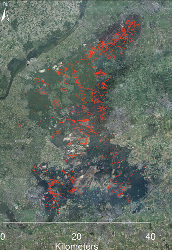
Only the hollow-ways were mapped, covering a large part of the Veluwe, represented in the Geographic Information System (GIS) ArcGIS. The three main directions are discerned in the hollow-way system; crossing the push moraines from west to east, along the northern ridge and along the west side of the Veluwe area (Vletter & Van Lanen Citation2018). The Harderwijkerweg is part of the latter.
CONTEXTUALISATION
Traces of Iron Age and medieval settlements have been found at a distance of 1,200 metres to the north-east. Pole holes, kogelpot pottery, Merovingian pottery, Badorf pottery, Pingdorf pottery and Maasland ware made up the remains. Besides pottery, also natural stone, basalt and burned clay has been found (Van Doesburg et al. Citation2011). The settlement lies like a cape about 2 metres higher in the totally sand-blown plain of Oud-Reemst due to fact that the settlement layers and surrounding field layers were more resistant against the sand blowing.
A reconstruction of the road was made in a Least Path Cost model in an earlier research (Vletter & van Lanen Citation2018). Possible wetness, slope and groundwater level were the determining factors in the model, whereas height and depressions defined the possible wetness of the area. Compared to the three other investigated roads on the Veluwe, the Harderwijkerweg is most sensible to groundwater level. Indeed, it runs mostly on dry sandy soils near the transition zone to wetter peat and clay soils when seen overlaid on the soil map.
Origin
Between 1052 and 1543 the Veluwe region belonged to the political territory of the Dukes, respectively Counts, of Guelders (Noordzij Citation2009). At the end of the twelfth century and in the first half of the thirteenth century the dukes enfranchised a series of towns in their territory, including the towns of Harderwijk (1231) and Arnhem (1233) at the borders of the Veluwe. The latter functioned as the capital of the Veluwe Quarter in those days. Both towns showed a rapid extension and economic growth in the thirteenth century, which makes it very likely that the important trade route between both towns called the Harderwijker- or Arnhemseweg dates from the same century.
Both towns had a very strategic position. Arnhem more or less controlled the Rhine trade between Germany and the Netherlands and functioned as one of the main administrative and economic centres of the Dukes of Guelders in late medieval times (Verkerk Citation1983). In 1441, it became a member of the Hanseatic League, which connected them to many important trading centres in North-west Europe. Therefore, it is no coincidence that the Harderwijkerweg was known as the Hanzeweg (Hanseatic road) right up to the seventeenth century. Harderwijk was situated on the southern coast of the Zuiderzee, the inland sea that was directly connected to the North Sea trade and also had important textile industries and fish trade (Berends et al. Citation1968).
Historical trade route
Several sixteenth- and seventeenth-century manuscript maps depict the route of the old Harderwijkerweg in rather high detail The very early and richly coloured map of the Veluwe of Christiaan’s Grooten from the year 1570 for instance already shows a large part of the route (). Further, the detailed maps of Nicolaes van Geelkercken (1629; 1641), Barend Elshoff (1725) and Willem Leenen (1755) also show many details of the various parts of the route (). The maps make it clear that the trade route started at the north-western city gate of Arnhem leading uphill to the estate of Warnsborn and passing an extensive drift-sand and heathland landscape towards the solitary hamlet of Reemst. Close to the village of Otterlo the road passed the medieval communal forest of the Otterlose Bos and continued along the lower slope of the Guelders Valley towards Harskamp and Stroe. From there it climbed uphill again through the ancient woodlands of the Speulder, Sprielder and Putterbosch towards Ermelo, finally reaching the southern town gate of Harderwijk.
Fig. 7. Detailed maps of Willem Leenen from 1755 (central above), Barend Elshoff from 1725 (lower right) and Geelkercken van (lower left). The high and low road to Harderwijk are clearly depicted on first two the maps.
On some of the above-mentioned maps, just before Oud Reemst, going in the direction of Harderwijk, Harderwijkerweg splits into a lower and upper road. Avoiding sand-blown areas in summer times, as is suggested by regional researchers, could be the reason for this (Breman & Hofman Citation2009). Again, this division is not always shown on maps from the seventeenth, eighteenth and nineteenth century. This may be due to the sources the maps were based on or the importance given to this division. The upper version seems to run through the forest near Otterlo; the lower one seems to be the one near or on the track of the modern Harderwijkerweg. It is not clear which one is older.
In current toponyms of roads and streets the Harderwijkerweg is still retraceable. Sometimes it is called the ‘Hardwijkerkarweg’, where Dutck kar stands for ‘cart’. Perhaps this is an indication that mainly carts were used on the road.
Termination
Written sources and maps suggest that the thirteenth-century Harderwijkerweg functioned until the early nineteenth century. Large parts of the sandy road were then straightened and paved, and placed under the authority of the newly founded province of Guelders. Other parts became deserted and replaced by new modern roads for some distance of the old road bundle. As a large part of the Veluwe has been common heathland until the nineteenth century, and was sold to large landowners and the state in the course of the nineteenth and early twentieth century, large parts of the medieval Harderwijkerweg can still be recognised in the field.
A comparison with historical maps of Krayenhoff from 1822 and the military topographical map of 1850 show that the road in the first decade of the nineteent century was straightened and paved, causing the old cart tracks to be abandoned.
Transport of goods
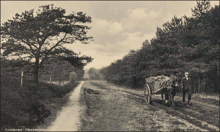
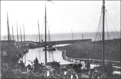
Fish was certainly a product transported from Harderwijker to elsewhere by carts and wagons. The Duke of Guelders gave Harderwijk the ‘staple right’ for fish between the Zuiderzee coastal places of Muiden and Kampen (). This right allowed fishermen to bring fish ashore and to trade in it. The bloater (smoked and salted herring) of Harderwijk was well known for its taste. The area of the German Rhineland was provided with fish from Harderwijk. A pickling technique for anchovy, invented by a member of the Harderwijker fishermen’s guild, was an improvement for the fish trade. The sold anchovy delicacy delivered high profits. However, the capture of anchovy was very irregular (Bos & Folkerts Citation1998). Wool, firewood, paper and rags, products from the Veluwe, were brought by cart and wagon to the port of Harderwijk for further export (ibid., 1998).
Plate III. Photo of old port of Harderwijk with carts and wagons.
ARCHAEOLOGICAL EXCAVATION OF THE HARDERWIJKERWEG
The excavation trench near Oud Reemst was situated in the nature reserve on the northern side of the push moraine of Oud Reemst ( and ). The area was checked for explosives with a metal detector before starting the excavation. Sunbsequently, the trench was dug across a hollow road. Archaeological finds were collected. The stratification of layers, including wheel tracks, were (preliminary) interpreted, photographed and mapped in the field. Consequently, samples were taken from wheel tracks and from just above the mother material. The wheel tracks selected had a clear uniform colour, were sufficiently large to be sampled, and looked interesting stratigraphically. Reference material was also taken from around the sample tubes. Then the samples and reference material were sent to the dating laboratory of the University of Oxford (). The outcome of the dating process was compared with historical sources and the interpretation of the stratigraphy. A multiple micropodzol (AE-Bhs-C), which had been developed in two thin layers of windblown sand from the late Subatlanticum, was a visible soil profile in the trench. The primary soil profile below was an of moderpodzol soil, which had been developed in coversand from the Weichselien (Bw-BCw-C).
Plate IV. An overview image, the archaeological drawing and an image of a partial 3D model of the trial trench. The red and yellow dots represent the places of the OLS samples. The yellow ones, from left to right, number 26, 28, 30 and 32 in the drawing, are dated. The green lines are of orientation support for the viewer.
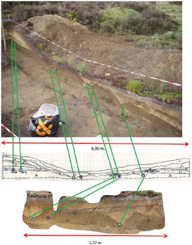
A relatively well-preserved podzol is present on both sides of the trial trench. The layers of this soil disappeared where the wheel tracks had cut in. Instead, sand-blown layers and eluviation layers from the side originating from the time of the formation of the wheel tracks and afterwards, were deposited here.
Three layers were dug in the trench with a 10–15 cm-height difference between them. Seven wheel tracks were identified from the excavation. The odd number of seven indicates that a part of the original wheel tracks had been erased by later ones or by geological processes (erosion). Those wheel tracks situated in different layers indicate a different period.
Heavily fragmented pottery, charcoal and metal objects were found during the excavation. The pottery found existed of a Pingsdorf sherd, kogelpot (a Dutch term for ceramics from round cooking bowls) sherd and a piece of reddish ware pottery. The Pingsdorf and Kogelpot sherds indicate that the route was in use in the late Middle Ages (thirteenth–fifteenth centuries). The reddish ware pottery could indicate the use of the road in the fourteenth–sixteenth century. In addition, late prehistoric pottery has also been found, which could relate to late prehistoric sites on the push moraine of Oud Reemst, such as burial mounds and Celtic fields. The small fragments of charcoal and the metal were not diagnostic.
OLS RESULTS
The OSL dating was carried out at the Research Laboratory for Archaeology and History of Art at the University of Oxford (). The results are summarised in . The measured dates have to be calculated back from 2017, the year in which the measurement took place. Moreover, the dates have a margin indicated with ±.
Plate V. A close up of the four dated OLS samples.
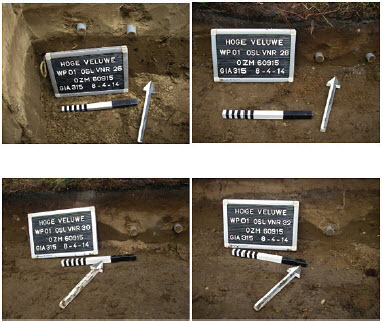
Table 1. Ols dating results.
The sample taken from the first windblown deposition directly next to the wheel tracks resulted in an age of a.d. 1222 ± 55 years. This matches the start of the trade route between Arnhem and Harderwijk in the middle of the thirteenth century. It corresponds with the rise of both trade cities: Arnhem got its city rights in 1221 and Harderwijk at 1231 (Verkerk Citation1983). OSL dates from the wheel tracks themselved showed younger datings, i.e. a.d. 1627 ± 30 years, a.d. 1812 ± 15 years and a.d. 1822 ± 15 years respectively. These datings reflect the long-term use of the route between the seventeenth and nineteenth centuries. Assuming that many of the old tracks have been erased due to incision by younger ones, these dates probably indicate the younger stages of use, which again corresponds with historical sources.
INTERPRETATION
To find a good combination between the different wheel tracks is hard, because various types of carts and wagons, thus wheel gauges, were used in the same period (Denecke Citation1969; Renaud Citation2008). Moreover, historical sources show that the historical Veluwe had three different zones regarding the type of locally used farm wagons and carts (Renaud Citation2008), which means that wheel tracks could vary intraregionally. Interestingly, in a 1753 source a card type called ‘Harderwijker’ is mentioned and price listed for ‘road money’ (Pieko Citation1993). A typical wagon from Harderwijk seems thus to have existed. The wheel gauge, however, is not known.
Nevertheless, three possible combinations of wheel tracks can be determined in the excavation trench based on wheel gauge and the comparable volume and incision of the wheel track. A first combination has a wheel gauge of 1.29 metres, which corresponds largely with the ‘Hollands Spoor’ distance of 1.28 metres for a cart (Fockema 1959). The vertical surface (volume) of both wheel tracks, with a height of 10 and 8 cm and both having a maximal width of 29 cm, are similar. The depth of both wheel tracks (above sea level) shows, however, a difference of 6 cm. For a wheel gauge of 1.29 metres, this may constitute an issue. Moreover, the tracks are situated in different stratigraphic layers and this undermines the combination. Different colours, brown and light brown, of the two wheel tracks further weaken it. In other words, the wheel tracks don’t seem to belong together.
A second combination shows much resemblance with the one above. There is the same difference in colour — brown and light brown — between the wheel tracks, and they are situated in different stratigraphical layers. The vertical surfaces have a height from 3 to 5 cm and a maximal width from 11 to 17 cm. It assumed that neither of these wheel tracks belong together.
A third combination has the two wheel tracks in the same stratigraphic layer and colour. Moreover, they are on the same height above sea level. The wheel gauge of 0.95 metre is however quite narrow. Another issue is the difference in vertical surface (volume) between the two wheel tracks. One has a height of 16 cm and a maximal width of 35 cm and the other a height of 11 cm and a maximal width of 25 cm. The latter also makes this combination doubtful.
Sometimes it is hard to distinguish between tracks and to reveal which geological processes have taken place. Nevertheless, a westward movement of the cart track was deducted from the stratigraphy of the wheel tracks (lying on top of each other). Further, after the abandonment of the route the cart tracks have likely been partially eluviated or blown over with sand. A similar process had probably also taken place in earlier phases considering the different depths of the wheel tracks.
Two findings were located in a wheel track that has been dated to 1822. These are kogelpot pottery and pottery with quartz. Both late medieval finds represent a period with does not line up with the OSL. Since they have been found in the same layer no or little value can be attributed to them and they have probable been transported from other sites into the wheel track. A possible deposition is through eluviation from the adjacent push moraine. The OSL dating is therefore probably more reliable, because they line up with historical sources.
Indeed, the results of the dating correspond with the use of the route in historical times, from the period when the route came into existence in the thirteenth century to its continuous use until the nineteenth century. As such, the OSL dates neatly correspond with the historical sources. However, the dates for wheel tracks 28 and 30 are inconsistent with the stratigraphic interpretation. In this interpretation wheel track 30 lies below wheel track 28, making wheel track 30 older. The OLS dating results point to the contrary. However, wheel track 28 (1812) and 30 (1822) are very closely dated and both have an error margin of 15 years. This makes it possible that the OLS dating still coincides with the stratigraphic interpretation. Besides, a wrong stratigraphic interpretation cannot be excluded. However, a strong resemblance does also occur. Namely, the fact that OLS 32 is older than OLS 28 and 30 coincides with the stratigraphy. Indeed, as mentioned, the stratigraphy interpretation suggests a westward movement of the wheel tracks over time. From this perspective, such post-quem dating of windblown layers and wheel tracks seems to offer good possibilities for the absolute dating of cart tracks.
CONCLUSIONS
The OLS datings of the Harderwijkerweg shed light on a possible use of this card track from the thirteenth until the beginning of the nineteenth century. A break between the dated periods of use is also possible. However, absolute conclusions cannot be drawn. The reason for this is twofold. Firstly, the dating, as mentioned above, should be considered cautiously. Secondly, the limited scale of the research hinders further conclusions. For instance, only one track out of a bundle of tracks was excavated and dated. It is not clear what the dating can tell about the other tracks. It is tempting to align them in the same period. However, only further excavation and dating could confirm such a hypothesis. For the Harderwijkerweg route altogether it is even more difficult to draw conclusions. Alternatives are known and the track (bundle) investigated could be one of them.
The results of OLS dating could support the view that the tracks of fossil road systems seen in the field and in the soil largely reflect the younger stages of the system, as most earlier tracks have been erased by younger wheel tracks as well as post-processual natural (erosion) and anthropogenic (agriculture and building) processes (Denecke Citation2007). Again, more and larger excavations and (improved) dating techniques are needed to reveal the secrets of historical roads. The Harderwijkerweg itself proved suitable for OLS dating. The outcome of the OLS corresponds largely with historical sources and with the stratification interpretation. The OSL dating and the small amount of pottery found barely correspond. Nevertheless, the OLS dating proved of value added to the historical road research. The excavation has provided insight into the structure of cart tracks and the geological and soil processes that have taken place.
Although the number of samples and dating are too low to provide a statistically reliable result, the combination of archaeology, historical sources and physical dating research (OSL) seems very promising for the near future in order to obtain more reliable absolute dates for wheel tracks on Pleistocene sandy soils in the Northwestern European Sand Belt. In another words OSL dating constitutes a meaningful contribution towards dating historical roads.
Acknowledgments
The authors thank Dr Stijn Arnoldussen (archaeologist, University of Groningen) for his guidance of the fieldwork.
PRIMARY SOURCES
- http://crustal.usgs.gov/laboratories/luminescence_dating/what_is_tl.html (no longer available)
- Plate I: https://middelpuntvannederland.nl/goudsberg-schatten/goudsberg-overige-attracties-3/hessenweg-middeleeuwen/
- Plate III: https://www.harderwijksezaken.nl/in-beeld/collectie-ribot-visserij-en-botters
BIBLIOGRAPHY
- Bailey, S., 2019. The Old Roads of Derbyshire Walking into History: the Portway and beyond (Leicester).
- Behre, K. E., 2008. Landschaftsgeschichte Norddeutschlands. Umwelt und Siedlung von der Steinzeit bis zur Gegenwart (Neumünster).
- Bekker-Nielson, T., 2004. The Roads of Ancient Cyprus (Copenhagen).
- Berends, P., Moll, J., & Van den Bosch, J.W., 1968. Kroniek van Harderwijk 1231–1931 (Arnhem, Netherlands).
- Bijster & Spek 2019. Snelwegen voor de koning. Onderzoek naar Veluwse wegen voor Willem III (1650–1702), Het Nederlandse Landschap, 3. 5–15.
- Bos, C. A., & Folkerts, J. A., 1998. De geschiedenis van Harderwijk (Amsterdam).
- Bourgeois, Q., 2012. Monuments on the Horizon: the formation of the barrow landscape throughout the 3rd and 2nd Millennium BC (Leiden).
- Breman, G., & Hofman, P., 2009. De Hoge Veluwe in kaart gebracht, Hoge Veluwereeks, 6 (Valkenswaard, Netherlands).
- Brindley, A. L., & Lantink, J. N., 1998. ‘Radiocarbon dates for Irish trackways’, J Irish Archaeol, 12, pp. 45–67.
- Brongers, A. J., 1976. Air photography and Celtic field research in The Netherlands (Amersfoort, Netherlands).
- Casparie, W. A. & Stevens, P., 2001. Bronze age stone-built way through an Irish bog: site Killoran 19, in Patina: essays presented to Jay Jordan Butler on the occasion of his 80th birthday, ed. W. H. Metz, B. L. van Beek & H. Steegstra (Groningen/Amsterdam), pp. 195–206
- Doneus, M., & Briese, C., 2010. ‘Airborne Laser Scanning in forested areas – potential and limitations of an archaeological prospection technique’, in Remote Sensing for Archaeological Heritage Management, ed. D. Cowley (Budapest, Hungary), pp. 53–76.
- Denecke, D. 1969 Methodische Untersuchungen zur historisch-geographischen Wegeforschung im Raum zwischen Sollingen und Harz. (Göttingen, Germany).
- Denecke, D., 2007. ‘Linienführung und Netzgestalt mittelalterlicher Verkehrswege – eine raumstrukturelle Perspektive’, in Straßen- und Verkehrswesen im hohen und späten Mittelalter, ed. R. S. Schwinges (Ostfildern, Germany), pp. 49–70.
- Ellis, C., 1998. ‘Archaeomagnetic dating and palaeochannels sediments: data from the mediaeval channel fills at Hemington, Leicestershire’, J Archaeol Sci, 25, pp. 149–63. doi: https://doi.org/10.1006/jasc.1997.0203
- Fockema Andreae, S.J. 1957. Hessenwegen. Mededelingen der Koninklijke Nederlandse Akademie van Wetenschappen, Afdeling Letterkunde 20/11, pp. 283–301
- Jones, A., Montanarella, L., & Jones, R., 2005. Soil Atlas of Europe (Luxembourg).
- Kokalj, Z., & Hesse, R., 2017. Airborne Lasers Scanning Raster Data Visualization. A guide to good practice (Ljubljana, Slovenia).
- Koster, E. A., 2009. ‘The European aeolian sand belt: geoconservation of drift sand landscapes’, Geoheritage, 1, pp. 93–110. doi: https://doi.org/10.1007/s12371-009-0007-8
- Leyden, F., 1940. ‘De jachttochten van de stadhouderkoning Willem III op de Veluwe’, in Bijdragen voor Vaderlandsche Geschiedenis en Oudheidkunde, ed. N. Japikse, 8 (1), pp. 242–56.
- Linford, P., 2007. Archaeomagnetic Dating (Swindon).
- McCann, W. A., 2003. The Archaeomagnetic Dating of two 14th–15th century hearths [online], Univ Wessex Southampton. https://www.wessexarch.co.uk/sites/default/files/projects/charter_quay/Dating/archaeomagnetic.pdf [accessed 6 June 2008].
- McIntosh, G., & Catanzariti, G., 2006. ‘An introduction to archaeomagnetic dating’, Geochronometria, 25, pp. 11–18.
- Noordzij, A., 2009. Gelre. Dynastie, land en identiteit in de late middeleeuwen (Hilversum, Netherlands).
- Opitz, R., & Cowley, D., 2013. Interpreting Archaeological Topography: lasers, 3D data, observation, visualisation and applications (Oxford).
- Pieko, L. A. J., 1993. De passagie der Hessenwegen. Over Hessen en Hessenwegen (Oldenzaal, Netherlands).
- Pierik, H. J., 2017. ‘Past human-landscape interactions in the Netherlands. Reconstructions from sand belt to coastal-delta plain for the first millennium AD’, unpubl Univ Utrecht Ph.D. thesis.
- Renaud, W. F., 2008. Wagens en karren. Diversiteit van voertuigen op het platteland en de collectie van het Nederlands Openluchtmuseum (Zutphen, Netherlands).
- Smith, N., 2011. Pre-Industrial Road, Track ways and Canals (Swindon).
- Spek, Th., 2007. ‘Kulturlandschaftsentwicklung in den Eschdörferlandschaften der nordöstlichen Niederlanden (Provinz Drenthe)’, in Historische Kulturlandschaftsforschung im Spannungsfeld von älteren Ansätzen und aktuellen Fragestellungen und Methoden. Institutioneller Hintergrund, methodische Ausgangsüberlegungen und inhaltlichen Zielsetzungen. Siedlungsforschung, ed. W. Schenk & R. Bergmann (Bonn), 24, pp. 219–50.
- Van der Sanden, W. A. B., 2002. ‘Veenwegen in Drenthe: enkele nieuwe dateringen’, Nieuwe Drentse Almanak, 119, pp. 101–12.
- Van Doesburg, J., De Kort, J. W., & Schreurs, J., 2011. Een middeleeuwse nederzetting in het Oud Reemsterzand, Waardestellend onderzoek in het Park de Hoge Veluwe in november 2009. Beknopte Rapportage Archeologische Monumentenzorg, 22 (Amersfoort, Netherlands).
- Van Heijgen 2015 De Veluwe als jachtlandschap: een onderzoek naar de locatiekeuze en ruimtelijke inrichting van jachtgebieden op de Veluwe tussen 1650 en 1930. Master thesis Landschapsgeschiedenis, Rijksuniversiteit Groningen, 2015.
- Van Lanen, R. J., 2017. ‘Changing ways. Patterns of connectivity, habitation and persistence in Northwest European lowlands during the first millennium AD’, unpubl Univ Utrecht Ph.D. thesis.
- Verkerk, C. L., 1983. ‘Arnhem van koningsgoed tot stad’, in Arnhem. Acht Historische Opstellen, ed. H. C. Bemmel (Gouda & Arnhem), pp. 1–40.
- Vletter, W. F., & van Lanen, R. J., 2018. ‘Finding vanished routes: applying a multi-modelling approach on lost route and path networks in the Veluwe region, the Netherlands’, Rural Landscapes: Soc, Environ, Hist, 5 (1), 2, pp. 1–19.
- Vletter, W., 2014. ‘(Semi) automatic extraction from Airborne Laser Scan data of roads and paths in forested areas’, SPIE proc Second Int Conference on Remote Sensing and Geoinformation of the Environment [online], SPIE Digital library. https://doi.org/https://doi.org/10.1117/12.2069709 [accessed 12 August 2014].
- Vletter, W. 2015. ‘A workflow for (semi) automatic extraction of roads and paths in forested areas from Airborne Laser Scan date’, AARGnews 50, pp 33–40.
- Vletter, W., 2020. ‘A methodology for the use of Airborne Laser Scan (ALS) data for historical road and path research in vegetated areas’, unpubl Univ Vienna Ph.D. thesis.
- Vletter, W., & Schloen, S., 2017. ‘Creating a chronological model for historical roads and paths extracted from airborne laser scanning data’, in Digital Methods and Remotes Sensing in Archaeology. Archaeology in the age of sensing, ed. M. Forte & S. Campana (Cham, Switzerland), pp. 405–35.
- Yokoyama, R., Shlrasawa, M., & Pike, R., 2002. ‘Visualizing topography by openness: a new application of image processing to digital elevation models’, Photogrammetric Engineering & Remote Sensing, 68 (3), pp. 257–65.
- Zakrzewski, S., Shortland, S., & Rowland, J., 2015. Science in the Study of Ancient Egypt (London).
- Zeeberg, J. J., 1998. ‘The European sand belt in eastern Europe and comparison of Late Glacial dune orientation with GCM simulation results’, Boreas, 27, pp. 127–39. doi: https://doi.org/10.1111/j.1502-3885.1998.tb00873.x