
ABSTRACT
Reservoirs change and control how water moves through the landscape. This article explores a key period in the development of reservoir technology at the turn of the nineteenth century which involved the construction of large reservoirs, such as Rudyard in north Staffordshire, which pre-date similar-size reservoirs for potable water. The creation of larger reservoirs in this period played an important role in the implementation of a resilient stable water supply to the canals, replacing a chaotic system of diverse water supplies to the earliest canals, which left them vulnerable to extreme weather. The development of larger reservoirs took place against a backdrop of changing dynamics in water ownership and entitlement to water, which had implications for the role and legacy of large reservoirs through to the present. Previous studies have concentrated on the economic or technological aspects of this period, with rapid expansion of the canal network. By examining the actions of established canal companies and unpicking the documentary evidence concerning the construction of Rudyard Reservoir, it will be argued that a complex combination of dry weather, competition for water and traffic, technological developments, and changing patterns of water management all contributed in creating a demand for large reservoirs to supply water to arterial canals in England and Wales.
‘no self-respecting animal would come within eyeshot of it except in times of drought, when the half-ruined tanks and reservoirs held a little water’ (Rudyard Kipling, The Jungle Book (1894).
Across much of Britain, reservoirs are perhaps the most important tool for managing water supplies, particularly during extreme weather events (Marsh Citation2012). Like Rudyard Kipling’s ‘self-respecting animals’, in times of drought we turn to reservoirs for a reliable water supply. Research to date has often focused on piped and potable water supply networks; however, the earliest long-distance water supplies and large-capacity reservoirs supplied water not for human consumption, but for the canal network (Herschy Citation2012; Harvey-Fishenden et al. Citation2019). The process of negotiation of water rights and responsibilities was undertaken by canal companies, who set many of the earliest structures and processes in place, with regulatory and legal requirements quickly evolving to meet the new challenges presented. The late eighteenth century saw major developments in reservoir construction to supply water to arterial canals in England and Wales, which allowed more ambitious control of how water moved through the landscape. This article will examine the importance of this period of reservoir construction, exploring a case study of Rudyard in north Staffordshire. Construction on Rudyard Reservoir (now more often called Rudyard Lake) began in 1797 by the Trent and Mersey Canal Company. As a dammed valley covering 2 miles, at the time it was the largest reservoir in Britain. Its size more closely resembles modern drinking water reservoirs than the earlier canal reservoirs, even though commercial piped water supplies and storage reservoirs were not widespread for another hundred years, until the beginning of the nineteenth century (Hassan Citation1985; Taylor et al. Citation2009; Herschy Citation2012). This article interrogates the archival source material relating to the Trent and Mersey Canal Company and its contemporaries, drawing particularly on the Lord’s committee discussion of the proposed reservoir (SRO, D593/V/3/29) and related notes (TNA, RAIL, 878/113).
The early water supply network developed to support Britain’s canals has attracted little attention in the wider water management story. The development of canal reservoirs and their contribution to canal water supply history has often been overlooked, consigned to a few paragraphs, seen as an inevitable and logical development in the face of increased canal traffic and the competition for water (for example, see Boughey & Hadfield Citation1994). Revill urges us to ‘examine transport as an act of making rather than an inert technology or product to be passively consumed’ (Revill Citation2007, p. 202): this examines the evolution of large-capacity reservoirs, born out of a chaotic system of diverse water supplies to the earliest canals, which left them vulnerable to extreme weather. Reservoirs played an important role in the implementation of more resilient water supplies and contributed significantly to the evolution of early water ownership rights. The process of planning and building large reservoirs occurred against a changing landscape of water rights and technological developments, which continues to shape contemporary water storage. Recent work in environmental history has begun to unpick the cultural role of drinking water reservoirs (McTominey Citation2019; Ritvo Citation2009), but early canal reservoirs remain understudied.
SUPPLYING WATER TO CANALS BEFORE 1797
The canal network expanded on an earlier system of natural and engineered navigable rivers (Bond Citation2007). River navigations were important for the economic development of towns in the seventeenth and early eighteenth centuries (Wanklyn Citation1996). However, they were often adversely affected by seasonal variation in flow and by the movement of sediments during periods of high flow, which in turn blocked shallow channels during dry periods (Revill Citation2007, p. 204). Contemporary engineers were aware of these problems: in 1803 Thomas Telford wrote of the inconvenience caused by variation of flow and shallow water (Telford Citation1803, p. 286). The modification of river channels, by widening, deepening or reducing sinuosity, was likely to increase the water velocity and therefore erosion rates and downstream silting (Rhodes Citation2007, p. 144). Technologically, they shared many similarities with the earliest industrial age canals; some rivers even had locks installed to control the flow and water level (Skempton Citation1957) or used short sections of canal to bypass difficult stretches of natural river. They did not, however, cross watersheds and did not impound water (Hadfield Citation1981, p. 19).
Early canals expanded and augmented the system of navigable rivers, as they redirected and controlled surface water, reducing the unpredictability of flows and increasing the reach of water transport into growing industrial areas. These canals were slow moving and relatively straight, so movement of sediment was less of a problem than it had been for improved rivers, unless inflowing waters introduced sediment. The proprietors and engineers of early canals expected to source an adequate amount of water from nearby streams. James Brindley (1716–1772), the engineer responsible for the design of the first fully engineered canal — the Bridgewater canal, reportedly said that the purpose of rivers was to, ‘supply water for canals’ (Palliser Citation1976, p. 234). This meant that early canals, like improved rivers, lacked the ability to manage seasonal variation in flows of water. The industrial canals also faced new challenges, such as crossing areas without easily available water to reach areas previously inaccessible by river (Boughey & Hadfield Citation1994, p. 47).
The reservoirs built at the same time as the first canals were surprisingly small, often with a surface area of less than 80,000 m2. These reservoirs regulated the flow of water in the canals, like contemporary mill ponds, holding sufficient water to last only a few days. They offered limited protection against summer dry spells or long-term rainfall deficits. Water transport in general is highly susceptible to extreme weather, with major disruptions caused by dry, wet and cold weather (Freeman Citation1980; Boughey & Hadfield Citation1994, p. 47). It is, therefore, surprising that the earliest canal builders did not undertake the construction of large reservoirs to better regulate the supply of water to the canals. The construction of reservoirs, however, was and remains expensive, and a shortage of investors meant construction costs often had to be kept low (Hadfield Citation1981, p. 52).
Although streams and small reservoirs were the main source of water for the early industrial canals, they were not the only source; some early canals were supplied from inception with water pumped or drained from mines local to or adjacent to the canals. On the Trent and Mersey Canal, according to letters written by one of the men instrumental in the construction of the canal, the potter Josiah Wedgwood (1730–1795), the Harecastle tunnel permitted additional waters from nearby mines to be delivered into the canal (Hadfield Citation1969, p. 20). Several canals including the Stourbridge Canal (16 Geo III c.28), Dudley Canal (16 Geo III c.66), Wyrley and Essington Canal (32 Geo III c.81) and Shrewsbury Canal (33 Geo III, c.113) were entitled to compel nearby mine owners and operators to raise their water to a suitable level to be conveyed into the canal. The histories of canals and mining in Britain are inextricably linked; many canal investors were mine owners, who recognised the benefit of canals for transporting their goods cheaply. Coal prices in Birmingham were reduced by 46 per cent after a canal was built connecting it to the coalfields at Wednesbury (Satchell Citation2017, p. 29). Mines often had an excess of water, which had to be pumped or drained (Endfield & Van Lieshout Citation2018a), a combination of surface waters during heavy rain and ground water. It made sense to use mine water in canals, since canals normally passed close to mines in order to transport the coal or ores, and mine water would often have provided a more consistent and, therefore, resilient supply than surface water alone (Endfield & Van Lieshout Citation2018b).
At the beginning of the process of planning Rudyard Reservoir, the agent of the Trent and Mersey Canal Company, John Sparrow, wrote to the Marquis of Stafford about the continued need for water from his mines, regardless of any new supply the canal company might acquire at the summit of the canal (SRO, D593/L/1/14/2). The potential of mine water as a supply for the canal, and the important relationship between the mine owners and the canal companies perhaps partially explains the reticence towards investing in reservoirs. Canal companies, however, were constantly searching for new water sources (Freeman Citation1980; Boughey & Hadfield Citation1994, p. 47). This was to prevent shortages during dry weather, but also to reduce the cost of maintaining the canal water level. The canals were built through a landscape where water was already in high demand, with canal companies required to pay compensation for water they took (Boughey & Hadfield Citation1994, pp. 47, 49). Late eighteenth-century industry was highly reliant on water power and therefore highly protective of water sources (ibid.). Tensions between water users and claims for compensation from the canal companies on the behalf of proprietors of river navigations, mills and fisheries were common. As noted in a letter written by an agent of the Trent and Mersey Canal Company that states ‘the aggregate amount of this compensation … [is] growing daily with the increase of trade and population’ (SRO, D593/L/1/14/2).
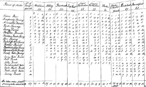
In 1792, the Trent and Mersey Canal Company measured the flow of the streams entering the canal between the head of the River Trent and Middlewich (SRO, D593/B/1/11/40). They then returned the streams to their original course and formed agreements with the mill owners along this stretch of canal regarding the amount of future payments should the canal have need of the stream water. These payments were ‘to [be made] according to a stipulated ratio which is not on any account to increase and is the same in dry seasons when alone the company can have occasion for them, as in wet’ (SRO, D593/L/1/14/2); thereby ensuring that the canal company could take the water when the need arose, but not pay for it when it was not necessary. illustrates the amounts assigned to each mill, and how many gauging points were tested along each stream.
Fig 1. 1792 agreement between Trent and Mersey Canal Company and mill owners regarding the amount of money due to mill owners if water is taken for the canal (SRO, D593/B/1/11/40).
During the 1790s, canal companies like the Trent and Mersey undertook a programme of water supply improvements, which simplified the previous systems, and moved away from a reliance of using surface water to supply canals. Against this backdrop of careful and controlled water management, canal companies began to consider investing in larger reservoirs. One of the first to do so was the Trent and Mersey Canal Company with their reservoir at Rudyard Vale. This became the test case, legislatively and technologically, for many future reservoirs.
THE DEVELOPMENT OF LARGE RESERVOIRS
Q. Do you know of any reservoir or forming so large as the proposed one?
A. I think I know of one not quite so large, but pretty nearly so-there is one of 140 Acres [56 hectares] or thereabouts, belonging to the Rochdale Canal, now making (SRO, D593/V/3/29, p. 38) [This probably refers to Blackstone Edge Reservoir].
When asked if they could show a precedent for the reservoir they were planning at Rudyard, the Trent and Mersey Canal Company pointed to the reservoirs being built for the Rochdale Canal, the first canal in Britain to rely solely on reservoirs (Clarke Citation2011). The Rochdale Canal presented a water supply challenge, requiring many reservoirs in addition to tunnels and water pumping; therefore, it was important and financially necessary to build relatively large reservoirs.
Although there were no large reservoirs in Britain when Rudyard was conceived, there were large canal reservoirs on the Continent. In France, the Canal du Midi, the first long-distance canal in Europe, is supplied by the Lac de Saint-Ferréol, about 50 km south-east of Toulouse (Clarke Citation2008; Mukerji Citation2009). This reservoir was completed in 1672, nearly a century before the construction of the first long-distance canals in Britain. The Lac de Saint-Ferréol is comparable in size to Rudyard, with a modern area of about 58 ha and little subsequent change apparent in its capacity based on the map produced by Jaillot and Cordier (Citation1700) (as measured from a Google Earth image dated 23/4/2017). The reservoir was essential to ensure water supplies during extremely dry summers in south-west France (Mukerji Citation2009, p. 54), which perhaps explains why it was included in the original plans for the Canal du Midi, while canals in ‘wet’ Britain were left without large reservoirs. It is possible that the perception of wetness in Britain (Taylor et al. Citation2014) in comparison to south-west France contributed to the failure of canal projects in Britain to originally invest in large-scale reservoirs from the beginning.
There were three other large reservoirs created in Britain at a similar time to Rudyard and of comparable size: Blackstone Edge (1798) used to supply the Rochdale Canal, Chasewater (1797, rebuilt in 1800 following failure in 1799) for the Wyrley and Essington Canal and Lake Bala (c. 1804) for the Ellesmere Canal (this involved increasing the level of an existing lake). Rudyard was originally planned at 77 ha, but the existing reservoir is more like 65 ha, with an estimated maximum capacity of 2,600 ML (Megalitres). Blackstone Edge had an area of about 20 ha, and a maximum volume of approximately 924 ML White Holme Reservoir (also on the Rochdale Canal) was planned in the 1790s, and had an area of 37 ha and an approximate maximum volume of 1,490 ML, but may not have been completed until the 1820s (Binnie Citation1987, p. 86). These reservoirs were necessary because the Rochdale Canal was unable to use water from streams and rivers for its supply (Clarke Citation2011). Chasewater (also known as Norton Canes or Norton reservoir), was built to provide water to the Wyrley and Essington Canal, with a surface area of 50 ha, and an estimated volume of nearly 2,000 ML. It was made necessary because of restrictive clauses in the 1794 act of Parliament (Public Act 34 Geo III c.25), which list many streams which cannot be used for the supply of the canal but do not restrict the use of mine water or flood water. Chasewater and Blackstone Edge reservoirs, therefore, were necessary in the original design of the canal because of a need to collect flood and rainwater rather than using local water sources.
In contrast, Lake Bala is a natural lake, which was adapted to be used as a compensation reservoir, supplying water to the River Dee to compensate for extraction downstream. The overall capacity of the lake greatly exceeds any contemporary reservoirs; however, the weir that was installed by the Ellesmere canal only raised the water ‘one foot higher on the surface than it usually falls to in dry weather in summer’, according to an agreement made with the landowner (Watkin Williams-Wynn) in April 1804 (TNA, RAIL 827/2/2). Since the area of the lake is 480 ha, the approximate volume of water accessible for the use of the canal company was 1,580 ML.
DRIVERS OF RESERVOIR DEVELOPMENT
Large reservoirs became necessary against a background of widespread changes to the way water was managed and the ‘canal mania’ (Boughey & Hadfield Citation1994, p. 83) of the late eighteenth century. Traditionally, commentaries on the development of canal water supplies in this period have focused on the increased competition from towns and the increasing traffic on the canals (for example, see ibid., p. 47). However, the balance and smooth operation of water supply systems was affected by a large number of network components including the economy, weather and regulatory law (van Lieshout Citation2016, p. 781). Ascribing the changes simply to the inevitable development of an industrialised system neglects the wider socio-political and environmental situation. While increasing competition and traffic were primary drivers of reservoir construction, the development of more resilient water supplies was driven by periods of particularly dry weather towards the end of the eighteenth century (Harvey-Fishenden et al. Citation2019), technological improvements (Binnie Citation1987), societal demands, competition with other water users and other canal companies (Hadfield Citation1981; Clarke Citation2011), and a changing political dynamic surrounding water ownership.
CHANGING DYNAMICS OF WATER MANAGEMENT
Canal companies’ relationships with water were governed by the contemporary patterns of water ownership and management. For the Rochdale and the Wyrley and Essington Canals, reservoirs were included in the early plans for the canals because of restrictions placed on the use of water from streams and rivers in the acts of parliament governing their construction. This was not the case for the earliest industrial canals.
The Trent and Mersey Canal’s original Act of Parliament, passed in 1766, allowed them to supply the canal from any spring, brook, stream or watercourse within 500 yards of the canal, except at the peak section crossing the Staffordshire-Cheshire border, where they could take water and build reservoirs anywhere within 5 miles (6 Geo III c.96). Some exceptions were included, but the only obstructive exclusion was that, in order not to prejudice the perpetually challenged navigation, fisheries and mills on the River Trent, the canal was restrained from taking any water from the river between Burton-upon-Trent and Wilden Ferry, near Shardlow. Similarly, the Duke of Bridgewater’s canal acts in 1758–62 gave the right to acquire water with or without the permission of landowners and water users, and with only minor restrictions (32 Geo II c.2, 33 Geo II, c.2, 2 Geo III, c.11). Over time, there was a shift in policy, both from government and canal companies, concerning water supplies to canals. As competition for water escalated, the level of water supply regulation increased accordingly.
Canal companies had the resources to pay compensation for the water, and the ability to purchase mills when necessary (Hadfield Citation1981, p. 69). The Trent and Mersey Canal Company and the Ellesmere Canal Company both purchased water-mills solely for their water supply (SRO, D593/L/1/14/2; TNA, RAIL 827/2/2) and the Staffordshire and Worcestershire Canal similarly leased water-mills in lieu of paying compensation (SRO, D3186/1/1/1). In this way they were able to acquire water supplies as needed, even to the detriment of others. These, however, were not long-term solutions, and only effective on a local level. Rivers suitable for operating mills could have many mills and weirs along their length (Downward & Skinner Citation2005, p. 139). Determining the impact of the canal on the surrounding area was a lengthy and expensive process, requiring agents of canal companies and major landowners to enter into lengthy discussions about the damage caused along the length of the affected watercourse. As early as 1795, an agent of the Trent and Mersey Canal Company described the payments that the company was obliged to pay to mill owners who were deprived of their water supply as ‘bothersome’, and ‘growing daily with the increase of trade and population’ (SRO, D593/L/1/14/2). From the perspective of the canal companies, it was desirable to find alternatives to using river water and dispense with the obligation to compensate other water users. Technological advances facilitated improvements in water management. This made it possible to reduce the amount of water needed for the canal and envisage a canal system no longer reliant on expensive surface water. On the Birmingham canals, for example, steam pumps were used to recycle water back up to the locks at Spon Lane from 1778 and at Smethwick from 1779 (Hadfield Citation1969, p. 70). Advances in tunnelling through unstable ground meant that in 1789, about ten years after the engines were installed, the number of locks leading to the summit were reduced from six to three (Hadfield Citation1969, p. 72; Bligh et al. Citation2007). Advances in engineering gave alternatives to building locks to traverse difficult terrain, such as the aqueduct used by the Ellesmere Canal and the 38 metre-high Pontcysyllte Aqueduct (finished in 1805) which traverses the River Dee (Boughey & Hadfield Citation1994, p. 89).
By the 1790s, the level of water supply regulation in Acts of Parliament relating to the construction of canals had expanded considerably. The process of obtaining an act for a canal generally involved some degree of justification of water resource management (Clarke Citation2011). The Act for the Rochdale Canal in 1794, for example, barred them from taking any water that was used to supply a mill, except in times of excess, thereby making the storage of rain and flood water essential to the operability of the canal (34 Geo. III, c.78). At the time, however, the large reservoirs that would allow the effective collection of rainwater were not being routinely constructed.
DRY WEATHER
[The Canals] have been in Want of Water almost every Year, but in particular in the Years 1785, 1788, 1789, and 1791, 1792, 1793, 1794, 1795, and 1796 (SRO, D593/V/3/29, p. 54).
Dry weather was a perpetual threat to canals that lacked water storage, with summer water shortages on canals common. A long-composite instrumental precipitation series has been reconstructed for Chatsworth House and analysed using the Standardised Precipitation Index (McKee et al. Citation1993) using a six-month window (SPI-6) (Harvey-Fishenden et al. Citation2019). Detailed analysis of the period 1777 to 1830 using the SPI-6 coupled with documentary evidence demonstrates that during the 1780s several droughts affected industry, farming and water supplies across Central England, with prominent droughts in 1785, 1788 and 1789; the 1785 drought was particularly severe. These droughts demonstrated the need for a reliable water supply and therefore the need for large-scale water storage to enable canals to be efficient and self-reliant systems. shows documentary evidence relating to canals, including water shortages, convictions for wasting water and canal improvements alongside the SPI-6.
Fig. 2. Annotated SPI-6 derived from the Chatsworth House reconstructed precipitation series (1777-1830), with dry (red) and wet (blue) phases denoted by distance from normal conditions (SPI 0), with archival source materials relating to water shortages displayed alongside hydrological droughts (grey bars). [1] TNA, RAIL 871/1, [2] SRO, D593/L/1/14/2, [3] SRO, D3186/1/1/1, [4] SRO, D593/V/3/29, [5] SRO, D3186/1/7/1, [6] SRO, Q/SB 1792 A/14, [7] TNA, RAIL 871/113, [8] TNA, RAIL 871/2, [9] SRO, Q/SB 1810 T/466, [10] SRO, D3098/8/11, [11] SRO, Q/SB 1824 T/3, [12] SRO, Q/SB 1829 T/7.
![Fig. 2. Annotated SPI-6 derived from the Chatsworth House reconstructed precipitation series (1777-1830), with dry (red) and wet (blue) phases denoted by distance from normal conditions (SPI 0), with archival source materials relating to water shortages displayed alongside hydrological droughts (grey bars). [1] TNA, RAIL 871/1, [2] SRO, D593/L/1/14/2, [3] SRO, D3186/1/1/1, [4] SRO, D593/V/3/29, [5] SRO, D3186/1/7/1, [6] SRO, Q/SB 1792 A/14, [7] TNA, RAIL 871/113, [8] TNA, RAIL 871/2, [9] SRO, Q/SB 1810 T/466, [10] SRO, D3098/8/11, [11] SRO, Q/SB 1824 T/3, [12] SRO, Q/SB 1829 T/7.](/cms/asset/28975180-7e42-4a5b-9c19-7379ee69531f/rlsh_a_1999016_f0002_c.jpg)
Although improving water storage and supply systems was the only long-term solution, there were some immediate measures taken by the canal companies to manage and mitigate the threat of dry weather and water shortages. On some canals heavy low-value goods such as road building and land-improving materials would be carried at lower toll rates during times of the year when water was plentiful but would not be carried during dry weather. A clause to this effect was added to the Trent and Mersey’s Act of Parliament in 1776 when they obtained an additional act in order to build the Caldon Canal;
And, in order to prevent the Consumption of Water by the conveying of Lime or Limestone, which, by the said first-recited Act, is to pay less Rates, Tolls or Duties, than are thereby authorized to be taken upon other Goods passing through the Locks upon the Navigation from the Trent to the Mersey, when there shall not be sufficient Water to supply the Lockage for Goods which pay the full Tolls, Rates or Duties authorized to be taken by the said Act; be it further enacted, That it shall not be lawful for any Boat, or other Vessel, carrying Lime or Limestone, to pass through any Lock or Locks upon the said Navigation between the Trent and the Mersey, except at Times when the Water flows over the Weir made to convey the waste Water from the Pound out of which such Lock or Locks is or are to be filled, without paying the like Rate, Tolls or Duty, which other Goods are liable to pay. (16 Geo III c.32).
This clause would save the canal company money, by reducing the compensation they might need to pay to other water users to procure water during times of shortage. It also reduced the impact of water shortages on paying customers. A similar clause was included in the Act for the Stourbridge Canal (16 Geo III c.28), obtained in the same year. There was an even more ubiquitous clause which aimed to save water during dry weather in the canal acts, the standard form of which was as follows;
And in all dry Seasons, when there shall be a Scarcity of Water in the said Cut or Canal, the Vessel going up the same, if within Sight of, and at a Distance not above Three hundred Yards below a Lock, shall pass through such Lock before the Vessel coming down, and then the Vessel next above shall come down; and if there are more Vessels than One below and above any Lock at the same Time in such dry Season, within the Distance aforesaid (at which Distance, a Post or Mark shall be set up or made for that Purpose) such Vessels shall go up and come down at such Lock by Turns as aforesaid, till all the said Vessels going up or coming down, shall have passed, by which Means, One Lock full of Water may serve Two or more Vessels.
Clauses of this nature appear in many acts of the late eighteenth century, such as the act for the Coventry Canal (1768, 8 Geo III c.36), Stourbridge Canal (1776, 16 Geo III c.28), Caldon Canal (a branch of the Trent and Mersey) (1776, 16 Geo III c.32), Dudley Canal (1776, 16 Geo III c.66), Shrewsbury Canal (1793, 33 Geo III c.113) and the Newcastle(-under-Lyme) Canal (1795, 35 Geo III c.87). The Rochdale Canal act goes further, stating that these regulations must be followed ‘at all times’ (regardless of the weather) (1794, 34 Geo III c. 78). Conserving water during dry weather was a standard part of daily canal operation, and routinely legislated for.
Additional measures were also taken to save water, including preventing leakage by raising the sides of the canal and prosecuting people who wasted water. In the 1790s the side weirs along parts of the Trent and Mersey were raised to reduce loss of water (SRO, D593/L/1/14/2). Records of convictions for wasting canal water are not common, but can be found in the Staffordshire Quarter Sessions records relating to October 1791 (SRO, Q/SB 1792 A/14, June 1824 (SRO, Q/SB 1824 T/3) and June 1829 (SRO, Q/SB 1829 T/7). During dry weather, however, nothing could immediately be done to remedy the problem of water shortages, in contrast to other weather events effecting the navigability of the canal, for which actions could be taken to immediately improve the situation. During heavy rainfall, sluices could be opened or closed to drain or redirect flood waters and during periods of freezing ice breaker boats could be used (Freeman Citation1980). In order to combat dry weather, more substantial measures were required to increase the storage capacity of the canal’s reservoirs and find alternative sources of water.
EXPECTATIONS
The expectations of canal users and their customers may have played a role in driving the creation of large reservoirs. Taylor et al. (Citation2009) identify that, with regard to commercial piped water supplies, the expectations of water consumers have shaped political and institutional framing of droughts. Similarly, the expectations of individuals and companies using the canals to deliver products and materials shaped the response of canal companies to dry weather and water shortages. The correspondence of some of the companies distributing their goods via the canal network reveal that generally delays resulting from frost or floods seem to have elicited more understanding from customers than those caused by water shortages.
Some delays were accepted as inevitable; Samuel Barnett and Company, manufacturers of tinplate in Kings Bromley, wrote to a new London-based client in 1797 warning them that their goods were transported via a ‘long inland water carriage subject in common with all water carriage to accidental delay’ (SRO, 6702/1). Uncertainty was a perpetual feature of water transport, whether by river or by canal, with maintenance, water levels or weather frequently problematic (Lindsay Citation1965, p. 42; Satchell Citation2017). No viable alternative mode of transport was available for low-value heavy and bulky goods, where profit was reliant on low travel costs (Satchell Citation2017, p. 3). For this reason, a degree of delay was accepted; however, delays were costly and annoying, and summer delays seem to have been met with more frustration and resentment than those incurred during winter (Boughey & Hadfield Citation1994, p. 52). In 1825, Joseph Parkes, writing on behalf of the subscribers to the scheme for a Birmingham to Liverpool railroad, claims that ‘fictitious stoppages from want of water have been managed on some canals’ (Parkes Citation1825, p. 47). There was great distrust of canal companies when they failed in their perceived duty to provide water and keep their canals navigable. In the 1790s, resilient water supplies were becoming increasingly necessary to meet the expectations of the users of water transport networks.
When it comes to water transport, flooding and freezing are absolute conditions, which completely stopped travel on the canals, often for several day or weeks at a time. Flood water and ice are also visually striking, and their effects would have been visible even away from the canal. This made it easier for transport delays to be ascribed to flooding or ice. Water shortages were different. Dry weather which caused shortages on canals might not have had major impacts elsewhere, creating delays which were hard to predict. The effects of dry weather could, therefore, have been perceived as less inevitable than the effects of wet or cold weather, and the delays therefore less acceptable.
INCREASING TRAFFIC, INCREASING COMPETITION
Conventionally, the expansion of the canal network and the construction of large-scale reservoirs has been attributed to increasing canal traffic and competition, however it is hard to find exact figures for canal traffic and therefore to substantiate this. Records of canal traffic even in the late nineteenth century were hard to compile as remaining records were often incomplete or duplicated (Vernon-Harcourt Citation2015, p. 480).
The information contained within historical archives are often incomplete, and its survival fortuitous (Ibsen & Brunsden Citation1996). There are many types of document relating to canals which once existed that can no longer be located. Much of the material that does survive has found its way into archives, not through the archives of the canal companies, but through the estates of canal subscribers, engineers and employees. Archival records of canals can be found in the Canal and Rivers Trust’s archive at Ellesmere Port, county record offices and The National Archive at Kew. One source of information about the operation and development of canals that often survives are committee minute and order books (Harvey-Fishenden et al. Citation2019). These are of varying usefulness when examining water supplies, dependent on the conditions of the canal and the priorities of the committee. Examination of the committee order book for the Staffordshire and Worcestershire Canal for 1766–85 (TNA, RAIL 871/1) identified three reports of floods, one report of water shortages and four mentions of water supplies. In contrast, the Ellesmere Canal Company committee minutes for 1796–1804 (TNA, RAIL 827/2/2) have one mention of flooding, one record of the canal freezing and about twenty-five reports or orders relating to water supplies. Different canals had different levels of water supply challenge, which can be gauged from the attention paid to water supplies in the committee minutes.
For Staffordshire in the eighteenth century, there are fragmentary records of canal traffic and tonnage from Radford Bridge near Stafford, on the Staffordshire and Worcestershire Canal, for 1772 and 1773 (SRO, D3186/1/8/1/1-24). These records are incomplete, and only cover several months over two years, so it is impossible to use them to make generalisations about increases in traffic. However, there are some observations which can be drawn from them; notably from 1773 they show more companies and individuals operating boats. The Staffordshire and Worcestershire Canal records (SRO, D3186/1/8/2) also contain separate records of tonnage carried by the Burton Boat Company in 1773. There are some early nineteenth-century (1814–1822) abstracts of tonnage included in the records of Stourbridge Navigation Company (SRO, D3186/3/3/1/1-2 and D3186/3/3/2/1-8).
Some evidence for the traffic on the canal, and where boats were travelling to, can be found in the Clerk of the Peace for Staffordshire Canal Boat Register 1795–1797 (SRO, Q/RUb/1). This register was introduced following an Act of Parliament in 1795 (35 Geo. III c.58) which required vessels to be registered with the Clerk of the Peace. The register contains information about the owners and masters of canal boats, and the route that the boats normally operated on. Through the compilation of this data, it becomes apparent that the Trent and Mersey was the most frequently used route in Staffordshire (see ). In total over these three years of records, there were 377 boats registered, with 246 using the Trent and Mersey Canal for at least part of their normal route. It was probably also used by boats not based in Staffordshire, which are not included in the register. Unfortunately, the records for Staffordshire do not survive after 1797, so trends in the numbers of boats and the routes operated cannot be examined over time.
Fig. 3. Route information from the Clerk of the Peace for Staffordshire Canal Boat Index 1795–1797 visualised (Dark-light, most-least used). The historic boundaries of Staffordshire are marked by a thin grey line. (Background map data from Digimap, ©Crown copyright and database rights 2019 Ordnance Survey (100025252)).
It was important for the canal companies to maintain a reliable water supply in order to remain competitive in light of experimentation into alternative forms of transport. In 1826 the Bill to construct the first fully steam-powered railway, the Liverpool and Manchester Railway, received royal assent (Wild Citation2018). It was not long after the construction of the early canals that it became apparent that many of them were poorly supplied with water. Even the canal companies were experimenting with alternative, water-saving, methods of traversing gradients, such as inclined planes, where boats would be moved mechanically from one level to another, often with the use of rails (Hadfield Citation1981, p. 64). Some of the earliest railways fed canal traffic; however, by the 1830s most canals were facing competition from proposed railways, which would be able to operate during all but the most extreme weather conditions (Boughey & Hadfield Citation1994, p. 183).
Even if traffic on the canals was not stopped completely by water shortages, the loads might be reduced (Harvey-Fishenden et al. Citation2019). Stoppages and reductions in loads could have a significant economic effect, both on the canal company and the companies whose goods were transported on the canal. Reduced loads resulted in less tonnage transported on the canals and, therefore, reduced tolls. Companies reliant on the canal for delivering their raw materials could find their factories brought to a standstill by water shortages. Samuel Barnett and Company’s letters record that the factory was unable to produce some products due to a shortage of water in August 1796, while one of their iron suppliers, Thomas Barker of Penkridge, suffered water shortages in June 1798 (SRO, 6702/1). For canal companies, further water supply challenges occurred when loads had to be reduced. During periods of normal supply, boats carrying less than a set tonnage were not allowed to pass through locks without the permission of the canal company or would be charged extra to do so. This meant that canal companies were guaranteed a certain amount of revenue per lock full of water, which allowed them to regulate the amount they paid for water to remain in profit. During times of shortage, when many boats would be necessarily navigating under the required tonnage, they could not charge in this way, despite needing to obtain extra water supplies at extra cost. The canal companies might have to face increased traffic from boats making multiple lighter trips at the time when water was at its scarcest.
In addition to the immediate problems caused by navigating with reduced loads, longer-term delays could result from goods waiting for boats building up in warehouses (Lindsay Citation1965, p. 42). Even once the canal was fully operational again, delays would continue as this backlog was cleared. This happened whatever the cause of the stoppage or reduction of cargo on the canal, whether from frost, flooding, dry weather, or planned closure. The letters of Samuel Barnett and Company record that in 1799, due to a combination of a frost stoppage and a warehouse backlog, tin plates sent to the warehouse to await canal transport on the 29th of January did not leave the warehouse until the 13th March, and had not arrived at their destination by the 30th March (SRO, 6702-1). Canal companies needed to work to avoid stoppages and reductions in load on their navigations wherever possible. In order to remain competitive and meet the expectations of their customers, the canal companies needed to ensure their water supply systems were resilient.
BARRIERS TO RESERVOIR BUILDING
There were two principal reasons why large reservoirs were not built at the same time as the earliest industrial canals: cost and safety concerns. Reservoirs required large amounts of land, with high initial outlay to cover construction costs. This meant they were only likely to be built when they could save money, or could make money, by vastly improving the network. Even when reservoirs were planned, several decades could pass between initial planning and construction. For example, the Staffordshire and Worcestershire Canal’s reservoir near Pottal Slade was first considered in the 1770s, and was revisited and surveyed multiple times, before construction during the 1820s (TNA, RAIL 871/1).
Building large dams was also a safety concern, since earth dams sometimes failed in times of heavy rainfall, with potentially litigious consequences. For example, the Blackbrook Reservoir dam built for the Charnwood Forest Canal (built 1795–7) failed in 1799 and again in 1801 (Binnie Citation1987, p. 76). Similar incidents on the Trent and Mersey Canal are also noted: William Robinson reported to the lords committee on Rudyard Reservoir that one of the company’s reservoirs’ dam had broken (SRO, D593/V/3/29, p. 49). For this reason, expanding any of the existing Trent and Mersey reservoirs was undesirable, and a new location with a different style of dam was needed. The dam for Rudyard Reservoir was innovative, with the layers built in order to maintain wet conditions in the clay core of the dam (Binnie Citation1987, p. 116). Additionally, unlike two of the company’s other reservoirs, Bagnall and Stanley, there was no mill directly below the proposed reservoir with rights to draw off water, or which might be destroyed by dam failure.
PLANNING AND BUILDING RUDYARD
The Caldon Canal, a branch of the Trent and Mersey in north Staffordshire was supplied by three reservoirs (Bagnall, Stanley and Knypersley; SRO, D593/V/3/29 p. 8.) These were the main reservoirs for the whole of the Trent and Mersey canal. The Caldon canal suffered frequent water shortages, as water was drawn down to maintain a supply on the main canal throughout the 1780s and 1790s (Harvey-Fishenden et al. Citation2019). A fourth reservoir (known as Bathpool or Harecastle) supplied the canal prior to Rudyard’s construction; however, it ceased to be used as a canal reservoir in the early nineteenth century (SRO, D997/v/2/1). Water shortages affecting the supply to the Trent and Mersey, and particularly the Caldon Canal, were reported in 1785, 1788, 1789, and 1791, 1792, 1793, 1794, 1795, and 1796. The drought of 1785 caused notable shortages and was the most severe drought in the late eighteenth and early nineteenth century in this region (see ); however, the shortages of water recorded in the 1790s are more complicated. The 1795 shortage does not seem to be directly related to a drought event; either canal traffic in this period exacerbated the issue of insufficient water storage, or the Trent and Mersey Company exaggerated the shortages to encourage their bill for Rudyard Reservoir through Parliament.
When the Trent and Mersey Canal Company began the process of obtaining an Act of Parliament to enable them to build Rudyard Reservoir, they believed it to be the largest reservoir ever constructed (SRO, D593/V/3/29, p. 54). The engineer John Rennie was consulted on the design and location of the new reservoir; his copy letter-book recording his visits to the planned site, in a valley in north Staffordshire, and their outcomes survive at the Institution of Civil Engineers Archive (ICE, REN/RB/02). The reservoir, as originally planned, was ten times the area of the Trent and Mersey Canal company’s previous largest reservoir at Knypersley: Rudyard was originally planned as 77 ha (190 acres) to Knypersley’s 8 ha (SRO, D593/V/3/29, p. 9). The Rudyard Reservoir, as with any new and ambitious venture, was met with some resistance and incredulity. The intention was that Rudyard would collect rain and flood waters during wet times of year, and that this water could be used to supply the canal during dry periods. Flood water had long been recognised as a potential source, but the engineering ability to store and discharge it safely had been insufficiently developed (ICE, REN/RB/02/001; ICE, REN/RB/02/042). Impetus to build large reservoirs gathered force as regulation of water use and competition increased. By the 1790s, experiences from constructing multiple canals and major canal engineering projects increased confidence in the capacity to build new types of reservoir, with canal companies offsetting the initial cost of building the reservoir against future water payments. Before the plans for Rudyard Reservoir were made public, surface water sources in the area were examined and judged to be insufficient to supply the canal with further water, especially considering the need to compensate water users for the loss of water to their enterprises (TNA, RAIL 878/113).
One of the concerns discussed by the Lord’s committee examining the Rudyard Reservoir proposal was that waters collected in Rudyard Vale, which would have drained to the Trent, would instead be fed into the summit of the Trent and Mersey Canal and, therefore, be split between the two rivers. This constituted a major conceptual change in the relationship between human actions on water in the landscape: not only could watersheds be crossed, but water could be transferred across watersheds. The proportion of water that would end up in each river was dependent on canal traffic, which was uncertain, with concern raised on the practical implications for industries downstream along the River Trent (SRO, D593/V/3/29). To address such concerns, it was determined that Rudyard Reservoir must maintain an outflow of equivalent volume to the stream that previously flowed through the valley to the River Trent. To this end, a ‘self-acting gauge’ was designed by Rennie, consisting of ‘a sliding plate with a hole or notch in it sufficient to afford the supply of water wanted for the mills – this plate to be connected to a large float of timber which would rise and fall with the water in the reservoir and thereby keep the notch at one depth under the surface of the water’ (ICE, REN/RB/02/042).
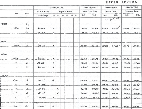
Temporary gauging of rivers andstreams was an important component in assessing compensation payment made by the canal companies, as seen in . Details of how gauging was undertaken are not specifically recorded, however, it is likely to have been through the use of stageboards, with little continuous gauging or recording systematically undertaken even in the twentieth century (Gunston & Bayliss Citation2009). There are later reservoir level and rainfall records including weekly reports made between 1896 and 1958 for Rudyard (SRO, 6783/1). Whilst few records are retained of water levels, a series of dock levels for the River Severn since 1862 are held by the Environment Agency archives, a legacy from the old River Severn Water Authority (), with these docks often being the connection between canal and river.
Fig. 4. Extract of a scan from a microfiche copy of archival records of flood levels from docks along the River Severn (River Severn Water Authority, n.d.).
ROLE AND LEGACY OF LARGE RESERVOIRS
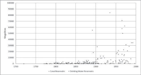
The large canal reservoirs built at the turn of the nineteenth century, such as Rudyard and Chasewater, pre-date and set the precedent for potable water reservoirs. The approximate dates of construction and capacity of reservoirs in England and Wales are illustrated in . Reservoirs are only included when a date of construction and a volume can be found or be reliably estimated. It therefore includes most large reservoirs that are currently in use, and documented service reservoirs belonging to the Staffordshire Potteries Waterboard (SRO, D3742/3/4/1/7). All canal reservoirs with available data for the Midlands and North-West England, and canal reservoirs which remain in use today across Britain, are included. demonstrates that canal reservoirs were normally much smaller than modern potable water storage reservoirs, but that the first phase of major reservoir construction was carried out to supply canals not potable water. The first large potable water reservoirs include Belmont (1826), Lower Rivington and Anglezarke (1857), and Audenshaw (1882), designed to supply the rapidly expanding areas of Greater Manchester and Liverpool. In the late nineteenth century large lake reservoirs such as Lake Vyrnwy and the Elan Valley reservoirs were created, which dwarf previous reservoirs (Hassan Citation1985; Herschy Citation2012).
Fig. 5. Estimated Capacities (in megalitres) for Canal and Drinking Water Reservoirs based on original designated use (1700–2000).
Water was fundamental for the operation of steam engines which powered the industrial age, but also good water supplies produced economic power for the canal companies; excess water could be sold to other industries and canal companies. In 1827, an Act of Parliament was passed for a new canal, between the Staffordshire and Worcestershire Canal and the Ellesmere and Chester Canals. This section of canal was unusual; because of the terrain, it would obtain its water from the Staffordshire and Worcestershire Canal. To compensate for this, the tolls from the new canal were to be paid to the Staffordshire and Worcestershire Canal Company. In this context the canal tolls are a payment for the use of the water in the canal. The Staffordshire and Worcestershire Canal company were able to exploit the stable water supply provided by its reservoirs to producing revenue. In turn, Chasewater allowed the Wyrley and Essington Canal, and its successor the Birmingham canals, to sell water to the Staffordshire and Worcestershire Canal Company (Boughey & Hadfield Citation1994). By the 1960s, two-thirds of the income from canals came from selling water, mostly for industry and agriculture (Watts Citation1967, p. 310). Today, reservoirs are still a source of economic power; they allow pumping systems to be switched off at peak times to save electricity — supplying water through gravity, they also provide a service by regulating flows of water to reduce the impact of extreme rainfall and, increasingly, have become a leisure destination, encouraging tourism. shows some of the leisure uses of reservoirs in the early twentieth century.
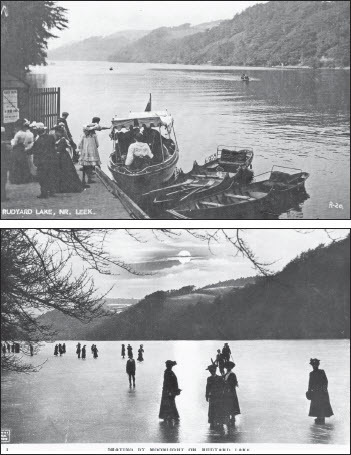
Plate I. In addition to their water supply function, reservoirs became a leisure destination. In these early twentieth-century photographs people can be seen skating and boating on the reservoir at Rudyard. Then photographs were taken from the western shore at the southern end of the reservoir about 300 m away from the dam, looking NNE away from the dam. While these photographs give an impression of the large extent of the reservoir, they are taken at the narrower end. Rudyard is which is nearly 3km long and over 300 m wide at the widest part. Images © Staffordshire Museum Service, reproduced with permission.
CONCLUSION
The early canals were an important element of industrial infrastructure and an essential step in the process of developing more resilient large-scale water systems to overcome periods of water stress. The creation of Rudyard Reservoir coincided with a notable shift in attitude towards the use and management of water, reflecting a change in the extent of authorisation given by Acts of Parliament to canal companies in taking and dominating water rights. Whilst this article has demonstrated changes in water rights in the period of reservoir construction for canal supply, these same challenges were present at the end of the nineteenth century during the planning of reservoirs for potable supply. Many of the barriers to reservoir construction remained the same, but larger reservoirs also resulted in the loss of communities, such as Llanwddyn, which was submerged during the construction of Lake Vyrnwy in north Wales, built to supply water to the rapidly expanding city of Liverpool. Early reservoirs, such as Rudyard, should be recognised as an important development in the evolution of water rights in England and Wales and an important feature of the water landscape. The eighteenth century has been described as a key period in the ‘remaking’ of human-nature relationships (Revill Citation2007); this is particularly evident in the case of the canals and reservoirs, where we see that the ability to store and transfer water affecting human interactions with the landscape on a scale not previously witnessed. These canal reservoirs paved the way for the large reservoirs which manage potable water today, and form an important part of the landscape. Indeed in The Making of the English Landscape, Hoskins remarked that ‘of all the changes in the last two generations, only the great reservoirs of water for the industrial cities of the North and Midlands have added anything to the scene that one can contemplate without pain’ (Hoskins 1995, p. 298).
ACKNOWLEDGMENTS
This work was undertaken as part of an Arts and Humanities Research Council (AHRC) Collaborative Doctoral Award Studentship in partnership with the Staffordshire Record Office.
ARCHIVAL SOURCES
- Institution of Civil Engineers Archive
- ICE REN/RB/02/001 Copy of letter written by John Rennie regarding Rudyard Reservoir 28th February 1797.
- ICE REN/RB/02/042 (1797) Copy of letter written by John Rennie regarding Rudyard Reservoir 20th November 1797.
- Staffordshire Record Office
- SRO 6702/1 (1796–1803) Letter Book of Samuel Barnett & Co., tin plate manufacturers of Kings Bromley.
- SRO 6783/1 (18961958) Weekly reports on Rudyard Reservoir.
- SRO D3186/1/1/1 (1766–1845) Minutes of the half-yearly general meetings of the Staffordshire and Worcestershire Canal Company.
- SRO D3186/1/8/1/1-24 (1772–3) Accounts of carriage of freight on the Staffordshire and Worcestershire Canal and Trent and Mersey Canal passing or using Radford Wharf or bridge and/or Haywood Wharf.
- SRO D3186/1/8/2 (1773) Staffordshire and Worcestershire Canal company records of tonnage carried by the Burton Boat Company in 1773.
- SRO D3186/3/3/1/1-2 (1814–1819) Half-yearly abstract of tonnage on coal and merchandise on the Stourbridge Canal.
- SRO D3186/3/3/2/1-8 (1816–1822) Balance sheets showing accounts with abstract of tonnage on the Stourbridge Canal.
- SRO D593/B/1/11/40 (1792) Copy agreement between Mill owners on the River Trent and the Trent and Mersey Navigation Co. respecting compensation for streams directed from the mill to supply the canal.
- SRO D593/L/1/14/2 (1795) Letter from J. Sparrow, agent of the Trent and Mersey Canal to the Marquess of Stafford regarding water supplies to the canal.
- SRO D593/V/3/29 (1797) Minutes of the proceedings of the Lords Committee, on the Bill for Rudyard Reservoir.
- SRO D997/V/2/1 (1819) Assignment from the executors of Thomas Breck deceased to a trustee for Thomas Kinnersley Esquire of the residue of a term of 1000 years affecting the Bath House Estate in the Parish of Wolstanton.
- SRO, D3098/8/11 Miscellaneous documents concerning waterways and railways, including annual reports of the Trent and Mersey Canal Company. SRO Q/RUb/1 (1795–1797) Clerk of the Peace for
- Staffordshire Canal Boat Register.
- SRO Q/SB 1792 A/14 (1792) Conviction of John Gwinnett of Tipton, yeoman, for obstructing the Birmingham and Birmingham and Fazeley Canal Navigation by spilling and wasting the water, upon information of Samue[l] Bull of Smethwick, engineer, 24 Oct 1791.
- SRO Q/SB 1824 T/3 (1824) John Brindley junior of Norton in the Moors, boatman, for wilfully wasting water in the canal at Cheddleton by improperly drawing the floodgates at the Hazlehurst lock, Jun 1824.
- SRO Q/SB 1829 T/7 (1829) Conviction under the Canal Acts: John Timins of Kinver, boatman, for allowing a boat on the Staffordshire and Worcestershire Canal to strike against the bottom gate of the Stewponey Lock in Kinver before it was empty; Christopher Boden of Kinver, boatman, for wasting water at the Stewponey Lock on the Staffordshire and Worcestershire Canal at Kinver, Jun 1829.
- SRO D3742/3/4/1/7 (1913–1940) Staffordshire Potteries Water Board engineer’s reports relating to water supplies.
- The National Archives, Kew
- TNA RAIL 827/2/2 (1796–1804) Ellesmere Canal Company general committee minutes
- TNA RAIL 871/1 (1766–1785) Staffordshire and Worcestershire Canal Company Committee order book.
- TNA RAIL 878/113 (1796) Copy deposition of witnesses before the committee of the Trent and Mersey Canal Bill, 4th, 8th and 9th November 1796.
- Acts of Parliament (chronologically)
- Public Act 32 Geo II c.2 (1758) An Act to enable the most Noble Francis Duke of Bridgewater to make a navigable Cut or Canal from a certain Place in the Township of Salford, to or near Worsley Mill and Middlewood, in the Manor of Worsley, and to or near a Place called Hollin Ferry, in the County Palatine of Lancaster.
- Private Act 33 Geo II, c.2 (1759) An Act to enable the Most Noble Francis Duke of Bridgewater to make a navigable Cut or Canal, from or near Worsley Mill, over the River Irwell, to the Town of Manchester, in the County Palatine of Lancaster, and to, or near Longford Bridge, in the Township of Stretford, in the said County.
- Private Act 2 Geo III, c.11 (1762) An Act to enable the Most Noble Francis Duke of Bridgewater to make a navigable Cut or Canal from Longford Bridge, in the Township of Stretford, in the County Palatine of Lancaster, to the River Mersey, at a Place called The Hemp Stones, in the Township of Halton, in the County of Chester.
- Public Act 6 Geo III c.96 (1765) An Act for making a navigable Cut or Canal from the River Trent, at or near Wilden Ferry, in the County of Derby, to the River Mersey, at or near Runcorn Gap.
- Public Act 8 Geo III c.36 (1768) An Act for making and maintaining a navigable Canal from the City of Coventry, to communicate upon Fradley Heath, in the County of Stafford, with a Canal now making between the Rivers Trent and Mersey.
- Public Act 16 Geo III c.28 (1776) An Act for making and maintaining a navigable Canal from or near the Town of Stourbridge, in the County of Worcester, to join the Staffordshire and Worcestershire Canal, at or near Stourton, in the County of Stafford; and also Two collateral Cuts, one from a Place called The Fens upon Pensnet Chace, to communicate with the intended Canal near the Junction of Wordesley Brook with the River Stour; and the other from a Place called Black Delph, upon the said Chace, to join the first mentioned collateral Cut at or near certain Lands called The Lays, in the Parish of Kingswinford, in the said County of Stafford.
- Public Act 16 Geo III c.32 (1776) An Act to enable the Company of Proprietors of the Navigation from the Trent to the Mersey, to make a navigable Canal from the said Navigation, on the South Side of Harecastle, in the County of Stafford, to Froghall, and a Rail Way from thence to or near Caldon, in the said County; and to make other Rail Ways.
- Public Act 16 Geo III c.66 (1776) An Act for making and maintaining a navigable Canal within and from certain Lands, belonging to Thomas Talbot Foley Esquire, in the Parish of Dudley, in the County of Worcester, to join and communicate with the Stourbridge Navigation, at a Place called Black Delph, upon Pensnet Chase, in the Parish of Kingswinford, in the County of Stafford.
- Public Act 32 Geo III c.81 (1792) An Act for making and maintaining a Navigable Canal, from or from near Wyrley Bank in the County of Stafford, to communicate with the Birmingham and Birmingham and Fazeley Canal, at or near the Town of Wolverhampton in the said County; and also certain Collateral Cuts therein described, from the said intended Canal.
- Public Act 33 Geo III c.113 (1793) An Act for making and maintaining a Navigable Canal from the North End of the Shropshire Canal in the Township of Rockwardine Wood, in the County of Salop, to the Town of Shrewsbury in the said County.
- Public Act 34 Geo III c. 25 (1794) An Act for extending the Wyrley and Essington Canal.
- Public Act 34 Geo III c. 78 (1794) An Act for making and maintaining a Navigable Canal from the Calder Navigation, at or near Sowerby Bridge Wharf, in the Parish of Halifax in the West Riding of the County of York, to join the Canal of his Grace the Duke of Bridgewater, in the Parish of Manchester in the County Palatine of Lancaster; and also certain Cuts from the said intended Canal.
- Public Act 35 Geo. III c.58 (1795) An Act for requiring all Boats, Barges and other Vessels, of certain Descriptions, used on Navigable Rivers, and on Inland Navigations in Great Britain, to be registered.
- Public Act 35 Geo III c.87 (1795) An Act for making and maintaining a Navigable Canal from and out of the Navigation from the Trent to the Mersey at or near Stoke upon Trent, in the County of Stafford, to the Town of Newcastle under Lyme in the said county.
BIBLIOGRAPHY
- Bengtsson, L, Herschy, R. W., & Fairbridge, R. W. (eds), Encyclopedia of Lakes and Reservoirs (Dordrecht).
- Binnie, G. M., 1987. Early Dam Builders in Britain (London).
- Blair, J. (ed.), 2007. Waterways and Canal-Building in Medieval England (Oxford).
- Bligh, D., Brown, D., & Crowe, N., 2007. ‘Birmingham Canal, England—a future unlocked by Telford’, Proc Inst Civil Eng, 160 (5), pp, 56–60.
- Bond, J., 2007. ‘Canal construction in the early Middle Ages: an introductory review’, in Waterways and Canal-Building in Medieval England, ed. Blair, pp. 153–206.
- Boughey, J., & Hadfield, C., 1994. Hadfield’s British Canals: the inland waterways of Britain and Ireland, 8th edn (Stroud).
- Clarke, M., 2008. Midi Canal [online]. Encyclopædia Britannica; https://www.britannica.com/topic/Midi-Canal [accessed 24 May 2018].
- Clarke, M., 2011. ‘John Rennie and the Rochdale Canal, UK’, Engl Hist & Heritage, 164 (EH3), pp. 143–54.
- Downward, S., & Skinner, K., 2005. ‘Working rivers: the geomorphological legacy of English freshwater mills’, Area, 37 (2), pp. 138–47. doi: https://doi.org/10.1111/j.1475-4762.2005.00616.x
- Endfield, G. H., & Van Lieshout, C., 2018a. ‘Contested subterranean waterscapes: lead mining sough disputes in Derbyshire’s Derwent Valley’, in Waterways and the Cultural Landscape, ed. F. Vallerani & F. Visentin (London), pp. 86–100.
- Endfield, G. H., & Van Lieshout, C., 2018b. ‘Water and vertical territory: the volatile and hidden historical geographies of Derbyshire’s lead mining soughs, 1650s–1830s’, Geopolitics, pp. 1–23.
- Freeman, M .J., 1980. ‘Road transport in the English Industrial Revolution: An interim reassessment’, J Hist Geogr, 6 (1), pp. 17–28. doi: https://doi.org/10.1016/0305-7488(80)90041-9
- Gunston, H., & Bayliss, A., 2009. ‘Water from Wendover Springs: a history of the development and measurement of water flows from a canal supply source’, J Railway & Canal Hist Soc, No. 204, 36. 4, pp. 10–21.
- Hadfield, C., 1969. The Canals of the West Midlands, 2nd edn (Newton Abbot).
- Hadfield, C., 1981. The Canal Age, 2nd edn (Newton Abbot).
- Harvey-Fishenden, A., Macdonald, N., & Bowen, J. P., 2019. ‘Dry weather fears of Britain’s early ‘industrial’ canal network’, Regional Environ Change, 19 (8), pp. 2325–37. doi: https://doi.org/10.1007/s10113-019-01524-5
- Hassan, J. A., 1985. ‘The growth and impact of the British water industry in the nineteenth century’, Econ Hist Rev, 38 (4), pp. 531–47. doi: https://doi.org/10.2307/2597187
- Herschy, R. W., 2012. ‘Reservoirs, early British history’, in Encyclopedia of Lakes and Reservoirs, ed. Bengtsson, Herschy & Fairbridge, pp. 660–2.
- Hoskins, W. G., 1955. The Making of the English Landscape (London).
- Ibsen, M.-L., & Brunsden, D., 1996. ‘The nature, use and problems of historical archives for the temporal occurrence of landslides, with specific reference to the south coast of Britain, Ventnor, Isle of Wight’, Landslides in the European Union, 15 (3), pp. 241–58.
- Jaillot, A. H., & Cordier, L., 1700. Diocèse de Castres, dédié à Messire Augustin de Maupeou, Conseiller du Roy en ses Conseils Evêque de Castres (Google Earth image dated 23/4/2017).
- Kipling, Rudyard, 1894. The Jungle Book (London).
- van Lieshout, C., 2016. ‘Drought and Dragons: geography, rainfall, and eighteenth-century London’s water systems’, Technol & Cult, 57 (4), pp 780–805. doi: https://doi.org/10.1353/tech.2016.0107
- Lindsay, J., 1965. ‘The Butterfly Coal and Iron Works, 1792-1816’, Derbyshire Archaeol J, 85, pp. 25–43.
- Marsh, T., 2012. ‘Droughts and water management in England and Wales: with particular reference to reservoirs and lakes’, in Encyclopedia of Lakes and Reservoirs, ed. Bengtsson, Herschy & Fairbridge, pp. 224–31.
- McKee, T. B., Doesken, N. J., & Kliest, J., 1993. ‘The relationship of drought frequency and duration to time scales’, in Proceedings of the Eighth Conference on Applied Climatology, 17-22 January 1993, Anaheim, CA, American Meteorological Soc (Boston, MA), pp. 179–84.
- McTominey, A., 2019. ‘The “Leeds Lake District”: water supply, rural environment, and the cultural landscape in Victorian and Edwardian Britain’, Cult & Soc Hist, 16 (5), pp. 561–79. doi: https://doi.org/10.1080/14780038.2019.1695561
- Mukerji, C., 2009. Impossible Engineering: technology and territoriality on the Canal du Midi (Princeton & Oxford).
- Palliser, D. M., 1976. The Staffordshire Landscape (London).
- Parkes, J., 1825. A Statement of the Claim of the Subscribers to the Birmingham & Liverpool Rail Road to an Act of Parliament in Reply to the Opposition of the Canal Companies, 2nd edn (London).
- Revill, G., 2007. ‘William Jessop and the River Trent: mobility, engineering and the landscape of eighteenth-century “Improvement”‘, Trans Inst Br Geogr, new ser, 32 (2), pp. 201–16. doi: https://doi.org/10.1111/j.1475-5661.2007.00249.x
- Rhodes, E., 2007. ‘Identifying human modification of river channels’, in Waterways and Canal-Building in Medieval England, ed, Blair, pp. 133–52.
- Ritvo, H., 2009. The Dawn of Green: Manchester, Thirlmere, and Modern Environmentalism (Chicago).
- Satchell, M., 2017. ‘Navigable waterways and the economy of England and Wales: 1600–1835’, in The Online Atlas of Transport, Urbanization and Economic Development c. 1680–1911, ed. L. Shaw-Taylor, D. Bogart & M. Satchell, [online] available at: https://www.campop.geog.cam.ac.uk/research/projects/transport/onlineatlas/ [accessed 06/09/2021].
- Skempton, A. W., 1957. ‘Canals and river navigations before 1750’, in A History of Technology Volume III: From the Renaissance to the Industrial Revolution c.1500– c.1750, ed. C. Singer, E. J. Holmyard, A. R. Hall & T. I. Williams (Oxford), pp. 438–70.
- Taylor, A., Bruin, W. B., & Dessai, S., 2014. ‘Climate change beliefs and perceptions of weather-related changes in the United Kingdom’, Risk Analysis: an Int J 34 (11), pp. 1995–2004. doi: https://doi.org/10.1111/risa.12234
- Taylor, V., Chappells, H., Medd, W., & Trentmann, F., 2009. ‘Drought is normal: the socio-technical evolution of drought and water demand in England and Wales, 1893–2006’, J Hist Geogr, 35, pp. 568–91. doi: https://doi.org/10.1016/j.jhg.2008.09.004
- Telford, T., 1803. ‘Canals’, in Plymley, J., General View of the Agricultural History of Shropshire (London), pp. 284–316.
- Vernon-Harcourt, L F., 2015. Rivers and Canals: with statistics of the traffic on inland waterways: Vol. 2: Canals (Cambridge).
- Wanklyn, M., 1996. ‘The impact of water transport facilities on the economies of English river ports, c.1660–c.1760’, Econ Hist Rev, 49 (1), pp. 20–34. doi: https://doi.org/10.2307/2598446
- Watts, H. D., 1967. ‘The inland waterways of the United Kingdom in the 1960s’, Econ Geogr, 43 (4), pp. 303–13. doi: https://doi.org/10.2307/143251
- Wild, C., 2018. ‘Tracks across the Irwell: from the Liverpool & Manchester Railway to the Ordsall Chord’, Ind Archaeol Rev, 40 (2), pp. 74–87. doi: https://doi.org/10.1080/03090728.2018.1507166