
Abstract
Community severance occurs when transport infrastructure or motorised traffic divides space and people. Despite the growing awareness of its effects on the wellbeing of local communities, the problem is not usually assessed quantitatively or assigned a monetary value. This paper reviews existing practice and research on quantitative methods dealing with community severance. The problem is first decomposed into a series of questions, which are then used as a base to review the methods found in governmental guidance documents, technical reports, and academic studies. The paper ends with recommendations for the integration of severance issues into transport planning.
1. Introduction
The term ‘community severance' describes the effects of transport infrastructure or motorised traffic as a physical or psychological barrier separating one built-up area from another built-up area or open space. The problem has gained increased social and political relevance in recent decades due to greater concern about the vulnerability of some groups, given trends such as population ageing, increases in ethnic diversity, income inequality, and spatial segregation in many cities. The inclusion of concerns about walking mobility in transport planning is justified through their role in social inclusion (Rajé, Citation2004), environmental justice (Greenberg & Renne, Citation2005), sustainability (Rogers, Gardner, & Carlson, Citation2013), and as a social determinant of health (Mindell & Watkins, Citation2011).
Nevertheless, the issue has only slowly been introduced into transport planning. There is a lack of consistent guidelines for the identification and solution of the problem. When severance is considered, only broad assessments are made, generally lacking either rigorous quantitative measurements of the incidence and magnitude of the problem or any detailed qualitative input from the communities affected. Research on the topic is also much less extensive than research on other negative effects of transport, such as air pollution and noise.
The existing knowledge on severance is found mainly in technical reports commissioned by governmental agencies. These reports are difficult to access, especially those produced before the advent of the internet. In addition, their proposals have rarely been adopted by the institutions that commissioned them. The few academic studies also suffer from lack of dissemination, as most have been published in technical, rather than academic, journals. The apparent lack of advances is evident, for example, by the fact that studies over 20 years old (e.g. Clark, Hutton, Burnett, Hathway, & Harrison, Citation1991) are still quoted as some of the main references on the topic. Official guidance about transport appraisal also relies on documents that have not been updated for decades. For example, the official approach to the assessment of severance in the United Kingdom (UK) is based on the 1993 Design Manual for Roads and Bridges (UK HA, Citation1993).
A common characteristic of many papers is that they devote a considerable length of space to the definition of severance. However, there is little agreement between writers on this definition. Some authors assign the term “severance” to the impact of traffic and use “barrier effect” for the impact of infrastructure (Litman, Citation2012, p. 1). Other authors distinguish between ‘physical severance' (the changes in mobility and accessibility) and ‘social severance' (the wider social impacts arising from physical severance) (Read & Cramphorn, Citation2001; Tate, Citation1997) or ‘community cohesion' (the state of togetherness and unity within a community) (Quigley & Thornley, Citation2011).
There is also little international dissemination of research findings, especially of work in languages other than English, despite the wealth of knowledge produced in countries such as France (Héran, Citation2000, Citation2009, Citation2011a, Citation2011b; Loir & Icher, Citation1983), the Netherlands (Boon, Van Wee, & Geurs, Citation2003; Dekoninck, Gillis, Botteldooren, & Lauwers, Citation2010), Norway (Lerväg, Citation1984; Sælensminde, Citation2002, chap. 7), Sweden (Grudemo, Ivehammar, & Sandsröm, Citation2002), Denmark (Lahrmann & Leleur, Citation1994, app. 14–1; Meltofte & Nørby, Citation2012, Citation2013), and Brazil (Mouette & Waisman Citation2004; Silva Jr. & Ferreira, Citation2008).
This paper looks at methods to identify and measure the intensity of community severance and to assess its economic value. The review focuses on the physical effects of transport infrastructure and motorised traffic on people's mobility (physical ability to move around) and accessibility (ability to reach particular places), and not on the wider effects that stem from these. For example, this paper does not consider the extensive evidence of the negative impact of road traffic on public health (Mindell & Karlsen, Citation2012), social networks (Mullan, Citation2003; Sauter & Huettenmoser, Citation2008) and spatial segregation (King & Blackmore, Citation2013; Mitchell & Lee, Citation2014). The deterioration of physical conditions for walking mobility may also have local and non-local economic and environmental effects, if it leads to a shift to motorised modes of transport. The review also does not go into detail about qualitative research, which is covered only when linked to outputs from quantitative methods.
The next section decomposes the severance problem into a set of questions. Section 3 summarises international practice, and Sections 4 and 5 review methods to identify and value severance. Section 6 discusses the integration of severance issues into transport planning, and Section 7 concludes by identifying challenges and possible directions for future research.
2. Elements of Community Severance
The severance problem can be decomposed into four questions: what are the barriers restricting mobility and accessibility? who is affected? how do people travel? and where do they go? (). The two arrows in the figure below represent two conflicting movements: motorised modes of transport using large transport infrastructure and motorised or non-motorised modes using local infrastructure. Severance arises due to the dominant position of the first of these movements.
Figure 1. Elements to define community severance.
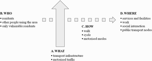
2.1. What Are the Barriers?
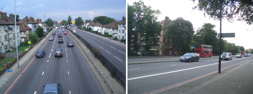
Restricted-access transport infrastructure such as railways, motorways, and dual-carriageways are physical barriers to local mobility because they provide a limited number of crossing facilities (left side of ). Motorised traffic using the infrastructure can also be a physical barrier, as it reduces the opportunities for crossing the road, especially in the case of roads with high traffic levels or speeds (right side of ). The negative, but variable effects of road traffic on pedestrians are labelled by some authors as ‘dynamic severance' (Guo, Black, & Dunne, Citation2001).
Figure 2. Static and dynamic severance.
Transport infrastructure and road traffic may be physical barriers even when crossing facilities are provided. Poorly designed or maintained facilities may create ‘secondary severance', if some people cannot access them, or perceive them as being dangerous or unpleasant (Bradbury, Tomlinson, & Millington, Citation2007). Crossings that are not at level and have steps cannot be used by people with restricted mobility and underpasses tend to be perceived as intimidating, especially at night time.
Even when barriers are physically crossable, they may still cause psychological severance to the residents of surrounding areas. This effect has been described in the literature as “felt aversion” (Lee & Tagg, Citation1976, p. 270) “feelings of being cut off” (Braddock, Citation1979, p. 172), “fear and intimidation” (Tate, Citation1995, p. 408) and “alienation” (NZTA, Citation2013, part A8.8).
2.2. Who Is Affected?
The phrase ‘community severance' suggests that the problem affects the residents in a given area. However, some authors are sceptical of identifying communities as socially cohesive groups living in geographically defined areas (Tate, Citation1997). The emphasis in this case should be on the group of people moving about in the affected areas, which might include workers and shoppers, as well as residents.
Within a community, there are also differences in mobility and accessibility needs, restrictions, experiences, and perceptions. Research may assign priority to identifying the problems of the groups more vulnerable to losses in pedestrian mobility, such as people with disabilities or limiting health conditions. Evidence also shows that the impact of traffic barriers depends on age (Hine & Russell, Citation1993, Citation1996; Russell & Hine, Citation1996) and leads to the loss of children's independent mobility (Hillman, Adams, & Whitelegg, Citation1990). Severance is also an issue when affecting groups who are facing limitations in the set of residences, destinations, or transport modes they can choose, which may include the unemployed, low-income households, and ethnic minorities. Gender is also relevant, as women tend to have lower access to cars, and to be more vulnerable when walking alone.
2.3. How Do People Travel?
The usual understanding is that severance restricts the mobility of pedestrians. However, the issue is also relevant to other means of transport. Cycling is a relevant example, but cited only rarely (Héran, Citation2000, Citation2011a; Read & Cramphorn, Citation2001). Methods to analyse severance experienced by cyclists may be different from those for pedestrians, because cyclists travel faster and are not always allowed to use crossing facilities (UK DFT, Citation2014a, p. 18). In an empirical study, Emond and Handy (Citation2012) show that motorways are a physical and psychological barrier to cyclists. Road-based public or private transport may also be affected, when local traffic is limited by bottlenecks at junctions with main roads. For example, Rajé (Citation2004) reports the case of a neighbourhood where car access is possible only by using a busy roundabout.
Barriers to mobility affect people's wellbeing, due to detours, delays, effort required to use bridges and underpasses, perceived danger, exposure to noise and air pollution, visual intrusion, and loss of sense of place. Individuals may then avoid severance by changing their behaviour. The changes can include complete suppression of trips, use of different destinations or travel modes, route diversion, and reduced use of streets as a social space. In the long term, households may respond to the problem by relocating to another area.
2.4. Where Do People Go?
The focus of many definitions of severance is the ‘divisive effect' of transport infrastructure, which assumes there are resulting losses in accessibility. These losses are especially relevant when they restrict the participation of individuals in activities that contribute to their social inclusion (SEU, Citation2003). Clark et al. (Citation1991) enumerated 30 types of facilities that an index of severance should consider, covering access to health, education, services, social activities, leisure, shopping, and transport. Handy and Clifton (Citation2001) considered the need to walk along and cross busy roads as factors influencing people's perceptions of walking to local shopping areas. Only a few early studies mention accessibility to workplaces (Braddock, Citation1979). The definition of severance given by the UK Department of Transport in 1983 (UK DOT, Citation1983) mentioned the separation of people from social networks, but later guidance documents removed this reference.
3. International Practice
Severance is mentioned in manuals for transport appraisal in several countries, listed in . In many cases, these documents do not indicate the attributes that define the severance problem, nor the methods to assess its intensity and to estimate its economic value.
Table 1. Official guidance for the measurement of severance
The UK Design Manual for Roads and Bridges (UK HA, Citation1993) is one of the few documents in use that outlines an explicit approach to assess severance, based on the impacts of road traffic on crossing delay and amenity value of walking and cycling trips. However, the method relies on the subjective classification of a large number of variables into just three levels of severance (slight, moderate, and severe). The case of Switzerland is similar: the ‘attractiveness' for pedestrians and cyclists are two of 39 attributes used in the eNISTRA transport appraisal tool. The assessment of these attributes requires quantitative inputs, but produces an output expressed on a qualitative scale.
Germany uses a simple method to measure and monetise severance. Pedestrian time losses are calculated from waiting times and the number of occasions that local residents cross the road. The monetary value is found by applying the value of time for personal trips. The Italian and Australian manuals also include simple formulas to quantify severance based on time losses for pedestrians.
Denmark and Sweden have used more detailed methods. In both countries, the barrier effect was assessed as a function of traffic variables and the number of crossing facilities. The effect was then multiplied by indicators of the need to access different types of facilities on the other side of the road. In Denmark, the effect was valued at 50% of the value of the noise effect and in Sweden the values depended on the age groups affected. These methods were used infrequently and inconsistently and have since been abandoned in both countries (Meltofte & Nørby, Citation2012, chap. 3; Tomlinson & James, Citation2005, pp. 8–9). More recent versions of project appraisal manuals include only general guidance.
4. Methods for Identifying Severance
4.1. Overview
Over the last four decades, researchers have produced a multiplicity of methods to measure severance more objectively than the approaches contained in official documents. is an overview of the questions addressed and the attributes measured by those methods. The table focuses on the effects of roads on pedestrians but most of the items also apply to other infrastructure (such as railways) and other groups (such as cyclists). Severance has been measured either as an obstacle to doing something (cross the road, walk around, or reach destinations) or as a factor reducing the quality of walking. The following four sections describe the indicators proposed in the literature to measure those effects and Section 4.6 points out some of the challenges faced in their application in transport planning.
Table 2. Indicators of community severance
The majority of the indicators presented are most useful when comparing the situation in the presence and absence of the barrier. However, the reduction of existing severance may require the use of different indicators than the creation of ‘new severance', as the impact on walking trips is also different. The use of behavioural measures may also be problematic as it may not be possible to observe behaviour before and after the changes. At the planning stage, only the current situation is observed; so the comparison situation must be forecasted by surveying the local residents or by using evidence on impacts of similar changes elsewhere.
4.2. ‘Crossability’
At its simplest, the assessment of barriers to mobility is the measurement of their physical attributes. In the case of road infrastructure, these attributes are carriageway width and number of lanes. In the case of road traffic, the relevant attributes are volume, composition, speed, and direction. The impact of traffic volume as a barrier is not linear, because after a certain level it causes a reduction in speed, which increases the number of opportunities for crossing, mitigating the barrier effect. Congestion, measured using indicators such as traffic density or the ratio between peak and off-peak speeds, may also be relevant. However, Smith and Gurney (Citation1992) found in a survey in London that congestion does not increase the perception of severance. Variables that were found to be significant in empirical studies of severance include the presence of parked cars (Hine, Citation1996; Hine & Russell, Citation1993, Citation1996), road layout (especially one-way gyratories and roads with many turning lanes) (Smith & Gurney, Citation1992), and the ratio between pedestrians and motorised vehicles (Héran, Citation2011a, p. 112). The ease of crossing a road also depends on crossing facilities, which can be assessed regarding their density, type, location, and quality.
The ease of crossing a road can be measured in terms of pedestrian delay, an approach used in early studies of pedestrian mobility (Appleyard, Gerson, & Lintell, Citation1981, chap. 4; UK MOT, Citation1963). Information on crossing delays can then be used in the estimation of journey times. The official guidance in the UK uses formulas from Goldschmidt (Citation1977) measuring the relationships between pedestrian delay and traffic flows for different types of crossing facilities. There is also a long history of research on crossing delay based on the distribution of gaps between vehicles in the traffic flow. Hunt and Williams (Citation1982) used this method to derive indicators for pedestrian average delay, the proportion of pedestrians delayed, and the proportion of pedestrians with a delay greater than a specified level.
The impact of a barrier can also be inferred from pedestrian behaviour. On-the-spot observation and video surveys enable the measurement of variables such as pavement flows, crossing flows, and pavement concentrations, and provide insights into crossing behaviour such as crossing location, path, speed, and hesitation. This information can then be used to create indicators of ‘crossability’. For example, Sisiopiku and Akin (Citation2003) measured compliance rates of pedestrians using different types of crossing facilities. Another possibility is the use of crossing ratios, that is, the number of pedestrians crossing the road as a proportion of the pedestrians walking along a section of the road (Hine & Russell, Citation1996; Russell & Hine, Citation1996). However, the use of these ratios to compare different streets or to assess changes in one street must take into account differences in the types of land use, location of points of attraction, and characteristics of the population walking in the area.
A more robust method to assess pedestrian behaviour is to estimate the trade-off values between walking distance or time and the barriers faced by pedestrians. For example, Jones, Wixey, Titheridge, and Christodoulou (Citation2005) used a stated preference survey to calculate people's willingness to walk longer times to avoid crossing busy roads, while Olszewski and Wibowo (Citation2005) modelled the relationship between propensity to walk and the characteristics of the routes taken, in order to derive the walking distances that are equivalent to the effort to overcome barriers.
4.3. Walkability
The impacts of barriers on mobility can also be assessed using indicators of walkability. A 2004 literature review found that the propensity to walk as a mode of transport and as a form of recreation is associated with a series of dimensions of the local built environment (Owen, Humpel, Lesli, Bauman, & Sallis, Citation2004). Since then, a large body of literature has been produced measuring walkability.
Street connectivity is one of the main elements of walkability and may be considered as the converse of severance (Handy, Citation2003, p. 120). Connectivity depends on street layout, continuity of pedestrian pavements, and, in general, the balance between the space allocated to motorised and non-motorised traffic (Hess, Citation1997). Connectivity is usually assessed by variables measured on the street network of a small area. Examples include the ratio between intersections and links, street length, or area; the ratio between street area and total area; the ratio between the street network distance and straight-line distance between pairs of points; the ratio between catchment areas around some point calculated using network distance and straight-line distance; the average distance between junctions; and the number of route choices between pairs of points. A full assessment of connectivity requires, however, the use of more sophisticated methods such as space syntax, to analyse the characteristics of the local street network, its relationships with the rest of the city, and the effects on pedestrian flows (Vaughan, Citation2007).
The use of pedsheds (also known as walkable catchment areas) is one way to measure lack of street connectivity together with other objective or perceived obstacles to walking. The method consists of identifying the areas inside a circle drawn around a given point that are judged to be feasible for walking and then calculating the ratio between the feasible area and the total area within the circle. Severance can be inferred by comparing the ratios obtained when busy roads are considered to be feasible and unfeasible areas for walking (Héran, Citation2011a, chap. 4; Jones et al., Citation2005; Porta & Renne, Citation2005; Schlossberg & Brown, Citation2004).
4.4. Accessibility
Severance can also be understood as a reduction of the ability of pedestrians to reach certain destinations. For example, Clark et al. (Citation1991) proposed an index that estimates the population living in the catchment areas of facilities to which access is impaired due to busy roads. The method did not consider the non-resident population and assumed that catchment areas are mutually exclusive and that people use the nearest alternative. This method was never used in practice, but informed the approach in use in the UK and the proposal by Tate (Citation1997) for the New Zealand Transport Authority, which added proxy variables for the effect on suppressed trips. This latter proposal was also never implemented.
Changes in accessibility can also be approached from the perspective of residential locations. A popular indicator of accessibility is Hansen's gravity-type measure (Hansen, Citation1959), the sum of the attractiveness of all possible destinations for people living in a certain place, inversely weighted by travel time. The effect of severance on accessibility is either the reduction of the number of accessible destinations or the increase in travel time. This type of indicator can be adapted for measuring the accessibility of non-motorised modes of transport (Iacono, Krizek, & El-Geneidy, Citation2010). Accessibility can also be understood as the availability of destinations for pedestrians. For example, the walking opportunities index (Kuzmyak, Baber, & Savory, Citation2006) is based on the number, character, and desirability of activities within a given walking distance.
The assessment of the effects on leisure walking trips, for exercise or socialising, is less straightforward, as assumptions are needed regarding the places where people meet (such as public spaces or each other's houses). Anciaes (Citation2011, chap. 2.3) proposed an indicator based on the loss of potential for population interaction, that is, the restriction on access to nearby locations, weighted by a function depending on population density.
4.5. Quality
Traffic barriers can also be assessed in terms of their impacts on the quality of local mobility. The exposure to motorised traffic has an effect on the amenity value of walking. This effect is especially relevant if we define severance as an issue affecting not only people crossing the road, but also people walking or cycling along the road (Héran, Citation2011a, p. 70; James, Tomlinson, & Reid, Citation2004). The assessment of amenity requires information about the street environment, such as the width and quality of pavements, user conflict, obstructions, lighting, and existence of facilities such as dropped kerbs, tactile information, and colour contrast. These aspects can be captured using methods such as the Pedestrian Environment Review System (Clark & Davies, Citation2009).
One of the impacts of road traffic is on people's risk of being victims of collisions. The analysis of patterns in collision data can provide insights into the role of road and street design and traffic control on pedestrian safety (Appleyard & Lintell, Citation1972; Hine & Russell, Citation1993). Risk can be measured directly using surveys (Davis, Citation1992; Tate, Citation1995, Citation1997) or estimated by a formula.
The way in which psychological barriers interfere with people's mobility cannot be captured just by measuring the attributes of infrastructure and traffic, or by observing pedestrian behaviour. Read and Cramphorn (Citation2001) argue that severance is defined by people's perceptions, cognitions, attitudes, and behaviours in the face of barriers. These reactions can be assessed through surveys. For example, Tate (Citation1995, Citation1997, chap. 5) measured perceptions of danger as the proportion of parents who stated that they would not allow their children to cross the road unaccompanied in locations with different traffic volumes, compositions, and speeds. Mouette and Waisman (Citation2004) used multiple correspondence analysis to model the relationships between different variables measuring people's perceptions of severance.
Photographs and video recordings can be used to synthesise objective information to be used in conjunction with surveys. For example, the analysis of surveys of perceptions can be compared with recordings of actual traffic conditions (Hine & Russell, Citation1993) or pedestrian behaviours (Sisiopiku & Akin, Citation2003). Conversely, recordings of traffic conditions (Hine, Citation1996) or photographs of crossing locations (Montel, Brenac, Granié, Millot, & Coquelet, Citation2013) can be shown to interviewees in order to elicit their responses.
Qualitative methods can also provide useful geo-referenced information that can be integrated with quantitative data to analyse the role of traffic on the quality of walking and street life. For example, Appleyard and Lintell (Citation1972) used dots, lines, and polygons to represent people's gathering places, acquaintances, and ‘home territories', respectively. Lee and Tagg (Citation1976) also translated the effect of new roads as a series of spatial variables derived from surveys, such as the size adjustment and shift of people's perceived neighbourhood, and ‘bridging' perceptions and behaviour across the road.
4.6 Challenges
4.6.1. Input assumptions
The estimation of severance is particularly sensitive to the value of some of the inputs. These include, for example, the set of pedestrian destinations. Clark et al. (Citation1991) mention a study where not including an important facility underestimated severance effects. Different values can also be defined for the traffic volume or speed thresholds that define severance, which may vary according to the characteristics of the population affected. Results are also sensitive to the indicator used to measure traffic volumes and speeds. Tate (Citation1995, Citation1997, chap. 5) showed different associations of pedestrian behaviours with different measures of volume (peak hour traffic, weekday average daily traffic, and 16-hour flow) and different measures of speed (space-mean, time-mean, and percentile values).
Another important input is the assumed maximum walking distance. Studies of pedestrian accessibility usually consider 400 m, 800 m or 1 km, depending on the type of destination. However, the reasonable walking distance for certain sections of the population, especially for elderly people, can be much lower than the average (Burton & Mitchell, Citation2006).
Hypotheses made about pedestrian route choice may also influence the results. The potential bias of using straight-line distances is revealed, for example, when comparing pedestrian conditions within straight-line and street network-based buffers around some point (Frank, Schmid, Sallis, Chapman, & Saelens, Citation2005) or in buffers with different radii (Manaugh & El-Geneidy, Citation2011). However, even street network maps tend to miss out informal links used by pedestrians as cut-throughs, such as parks, shopping centres, stations, and car parks, which may lead to an underestimation of accessibility and walkability (Chin, Van Niel, Giles-Corti, & Knuiman, Citation2008; Tal & Handy, Citation2012). The modelling of walking routes should also recognise that pedestrians may not take the shortest route, especially when walking for recreation. Walking behaviour is influenced by the pedestrian environment (Guo, Citation2009), gradient, land use, and by the need to use crossings not at-grade. Elderly pedestrians also face micro-level barriers such as steps, slopes, and obstructions on the pavement (Mackett, Achutan, & Titheridge, Citation2008).
4.6.2. Spatial context
Severance depends not only on the characteristics of roads and traffic but also on the spatial context of the surrounding neighbourhoods. For example, Poole (Citation2003) reports the results of surveys that show that the worst cases of severance in terms of people's willingness to walk and perception of quality of life were in towns and villages that straddled old, two-lane roads, and not in dense urban neighbourhoods near dual-carriageways.
The aggregation of severance effects to use in project appraisal also depends on assumptions regarding how those effects decrease with distance. Lee and Tagg (Citation1976) used samples at successive 200m bands from a major road and concluded that the familiarity with the area on the other side of the road and the number of trips to and social activity in that area do not decrease linearly with distance from the road. Loir and Icher (Citation1983, pp. 18–19) also argue that people living farther from the road are more able to separate severance from more tangible effects such as noise, and so they have a sharper perception of the problem. In addition, it is suggested that it is not distance as such but the type of land use between the residence and the road that counts.
There is also a cumulative effect of the presence of transport infrastructure alongside other infrastructure limiting the number of access points to areas outside a neighbourhood. Jacobs (Citation1961, ch. 14) talks about ‘border vacuums' created by transport corridors, industrial areas, car parks, university campuses, administrative centres, and hospitals, which fragment the city into units that are not self-contained. In an empirical study, Anciaes (Citation2011, chap. 2.3) mapped the cumulative effects of barriers caused by transport and industrial barriers in an urban area.
4.6.3. Time
The time dimension is also relevant. Accessibility needs vary by day of the week, with routes to workplaces being more important on weekdays and recreational routes more important on weekends. The impacts of road traffic on people's wellbeing also vary by time of day. James, Millington, and Tomlinson (Citation2005, p. 51) argue that traffic levels are more relevant during the day and traffic speeds more relevant at night. Counts of traffic and pedestrian flows should also take into account daily variations due to meteorological conditions.
There is also a need to forecast variables and update the inputs and specification of the indicators over time, to account for changes in traffic conditions, accessibility needs, and residential and land use patterns. Read and Cramphorn (Citation2001, p. 33) suggest that model parameters should be revised every five years.
The relevance of the problem for the local population also depends on how long the barrier has been present. Lee and Tagg (Citation1976) analysed perceptions and behaviours in communities separated by a major road for different lengths of time, concluding that, over time, the communities start to reorient themselves away from the road. It is important to consider the past and present degrees of community cohesion, which can be assessed by variables such as average length of residency and differences in socio-economic characteristics, type of dwelling, and mobility patterns of the population on the opposite sides of the barrier.
5. Methods for Valuing Severance
5.1. Overview
Even in the cases where severance effects are identified and measured, it is unlikely that they will receive the same attention as other impacts of transport projects unless they are converted into monetary units. If the value of severance is not made explicit, the effect may be downplayed because its implicit value appears to be zero (Handy, Citation2003, p. 139; Pearce, Atkinson, & Mourato, Citation2006, p. 31). Measuring the magnitude of the contributory factors is not enough, because the value of severance may not vary linearly with the variables measured, such as traffic levels and speeds, or the distance between roads and homes.
synthesises the results of empirical studies to estimate the economic value of community severance. Individual values have been converted to the same currency and adjusted for inflation, to aid comparisons. In most cases, the reduction of severance has a substantial positive value. The number of different attributes and units used in these studies confirms the existence of a multiplicity of problems caused by busy roads and of solutions to solve those problems in different areas.
Table 3. Empirical studies to estimate the economic value of community severance
5.2. Stated Preference
Stated preference methods use surveys to determine people's choices among hypothetical alternatives. These choices are modelled in order to assess preferences for attributes or packages of attributes, controlling for the participants' characteristics and usual attitudes and behaviour. The preferences are estimated in terms of willingness to pay for, or to accept, marginal changes in the levels of the attributes.
Contingent valuation is a simple form of stated preference method in which participants are asked about their willingness to pay for, or accept, a policy affecting the provision of some good or service. This method has been used in studies of community severance. For example, Soguel (Citation1995) and Grudemo et al. (Citation2002) estimated the willingness to pay for burying a road, using open-ended questions and binary choices, respectively. Valuation functions can be estimated relating willingness to pay with variables describing the characteristics of the road and the participants' characteristics and levels of exposure to the road.
Choice modelling is another, more complex stated preference method, which asks participants to choose from alternatives defined by several attributes, one of them defining the payment or compensation associated with each alternative. Choices are then related to attribute levels and with the characteristics of the participants using statistical models, from which willingness to pay can be derived. In the case of severance, the choices can be between different types of mitigation measures for the problem, or between the reduction of severance and other neighbourhood changes. For example, Grisolía, López, and Ortúzar (Citation2015) estimated the willingness to pay for burying a road considering the cost of the project and the types of land use on the surface. The studies of Garrod, Scarpa, and Willis (Citation2002) and Kelly, Tight, Hodgson, and Page (Citation2011) valued a series of attributes related with severance, including traffic volumes and speeds and pedestrian delay and detour caused by road crossings.
One of the challenges of using stated preference methods to value severance is to make sure that participants understand the attributes presented. This issue is usually addressed in the surveys by including images of different road designs and traffic conditions. However, images cannot transmit depth, time, and non-visual stimuli, so it is difficult to capture aspects such as traffic speed, visibility, noise, and dust. Some authors have also mentioned that surveys tend to underestimate the cost of severance because participants do not relate barriers to mobility with their wider impacts on their wellbeing (Héran, Citation2000, Citation2011a, p. 160).
The validity of the choices made by respondents to the survey is another important issue. Participants may be sensitive to the way they are expected to pay or receive compensation for the change in question. They may also hide their true willingness to pay or refuse to pay any amount. Familiarity with the choice scenarios also influences choices. In a study of traffic calming schemes, Boeri, Scarpa, and Chorus (Citation2014) found that participants who were unfamiliar with the scenario tended to minimise expected regret (for not having chosen the option with the best outcome in terms of an attribute), rather than maximise expected utility, which is the hypothesis of most of the stated preference studies. This may be explained by the participants' concern regarding the impacts on vulnerable dependents such as young children or older people.
5.3. Revealed Preference
Revealed preference methods derive people's willingness to pay by observing their choices in markets that act as surrogates for the good, service, or policy change studied. In the hedonic pricing method, the hypothesis is that the price of a market good incorporates the values of a set of tangible and intangible attributes. Choices in this market express people's willingness to pay for different levels of these attributes. The implicit value of each attribute can be determined by estimating a model relating the price paid with the levels of the attributes, using a large sample of consumers.
For example, the value of severance may be reflected in the housing market. Kang and Cervero (Citation2009) used hedonic models to estimate the effects on land values of a project in Seoul to demolish a motorway and replace it with a stream and a park. Lee and Sohn (Citation2014) estimated the benefits of projects in the same city to build tunnels to replace elevated and at-grade railways. Similar approaches have been used to value traffic-based severance. Kawamura and Mahajan (Citation2005) valued the cumulative impacts of vehicle traffic and Bretherton, Edwards, and Miao (Citation2000) valued traffic calming measures. A large number of hedonic studies have also valued aspects related with severance, such as walkability (reviewed in Bartholomew & Ewing, Citation2011) and roadside noise (reviewed in Nelson, Citation2010).
Hedonic models are notorious for being difficult to estimate. One of the main problems is that attributes may be correlated, or key variables may be omitted, which leads to inaccuracy in the estimated values. This problem is relevant in the case of severance, as the variables used to measure it are inevitably correlated with other nuisance factors, such as noise. It is also difficult to delimit the relevant housing market, that is, the set of properties considered by households. In addition, the market may not capitalise severance.
5.4. Beyond Preferences
The use of values based on preferences has some limitations. Individuals may not be aware of the problem or its consequences, or they may not perceive small or complex changes. Preferences may also be endogenous, that is, formed by the social context (Elster, Citation1983). Studies of people's preferences may also find unexpected results. For example, Stanley and Rattray (Citation1978, p. 144) quote a study where the majority of participants preferred the removal of severance to any level of monetary compensation. On the other hand, severance can have positive aspects. Natural barriers such as rivers and canals have an amenity value. The increase in gated communities and cul-de-sacs are also evidence that there is also a “demand for severance” (Handy, Citation2003, p. 138).
Objective valuations can be used as an alternative to preference-based methods. Severance has consequences for the economic, social, and health wellbeing of the individuals affected. Due to its influence on the choice between non-motorised and motorised transport modes, severance also affects aggregate economic and environmental variables. Some of the individual and social impacts may be linked to market goods, the value of which can be used as a proxy for the value of severance. Sælensminde (Citation2002, chap. 7; Citation2004, chap. 5) estimated the loss due to the non-realised benefit of a ‘natural amount' of walking and cycling due to road traffic, taking into account health impacts, work absences, school transport, and parking costs. The value of impacts of transport projects on physical activity is also included in appraisal guidance in several countries, using procedures such as the Health Economic Assessment Tool (WHO, Citation2011). The limitation of this kind of method is how to build a ‘dose-response function' that isolates the link between severance and health effects, among other confounding transport and non-transport, local and non-local, individual and social factors.
The results of valuation studies estimated in one area have also been applied in different contexts, a practice known as ‘benefits transfer'. The use of this type of approach has advantages in terms of objectivity and simplicity, but requires careful consideration of the similarity of the levels and nature of severance, characteristics of the population affected and the geographic, social, and political context of each place. In a study to estimate the external costs of transport in Switzerland (Ecoplan-INFRAS, Citation2014), data on the number of road and rail crossings per person per day in several cities were combined with the average time loss per crossing and a fixed value of time. The values were then extrapolated for the whole country. Chang, Han, Jung, and Kim (Citation2014) also used the results of a meta-analysis of values of walking time obtained in different areas to estimate the benefits of the reduction of severance associated with projects for relocating railways into tunnels in Seoul.
6. Recommendations for the Inclusion of Severance in Transport Planning
Issues of severance might be included in transport planning by adapting the methods found in the literature. The section proposes a framework to consolidate these methods, which as has been shown considered a wide range of different attributes defining severance and of procedures to combine these attributes into quantitative indicators. This framework also addresses some of the challenges in the identification and monetisation of the effects of severance mentioned in Sections 4.6 and 5.2–5.4. It is proposed that severance be formally built into three stages of the transport planning process: problem identification, option generation, and appraisal ().
Table 4. Measuring severance at different stages of transport planning
6.1. Problem Identification
Quantitative indicators can be used for analysing the incidence of severance within a broad area, for strategic transport and land use planning. Given the spatial coverage required for these indicators, and the need to update the inputs regularly, it may be more practical to measure the extent to which roads (or railways) separate the residents of each neighbourhood from their potential destinations (based on straight-line distance), rather than the extent to which they disrupt the routes to their actual destinations, estimated in the pedestrian network.
The resulting maps can be used by local authorities to identify severance hot spots (Communauté Urbaine de Strasbourg, Citation2012, p. 17). Héran (Citation2011a, chap. 5) proposed that these maps should be a part of plans for the prevention or reduction of severance, which should be compulsory in big cities, similarly to the plans required by European regulations for noise reduction. The mapping of severance also facilitates the analysis of the evolution of the problem (Anciaes, Citation2011, chap. 2.3) and the comparison of neighbourhoods with different socio-economic compositions (Neckerman et al., Citation2009).
6.2. Option Generation
Indicators of severance can also be a useful input to the generation of options for the design of new transport infrastructure or the redesign of existing infrastructure. In this case, the characteristics of roads and crossing points are treated as variables. For each combination of values for these variables, the analysis would involve the identification of the instances where the road disrupts walking (or cycling) trips of local residents to potential or actual destinations, identified using census and land use data and household travel diary data, where available. Statistics can then be calculated on delay and exposure to high traffic volumes or speeds. The inclusion of the impact on non-residents (such as workers and shoppers) is in most cases hindered by the lack of data on their trips across the affected areas of all possible options for the project.
Optimisation procedures can also be used to find the values of the variables that minimise severance. For example, the optimal alignment for a road can be defined as the one that minimises a cost function that includes severance effects across the neighbourhoods crossed by the road (Anciaes, Citation2013). Weights can be assigned to trips by vulnerable groups. A similar method can be used to find the optimal locations and characteristics of crossing facilities and the optimal allocations of road space to motorised and non-motorised traffic.
6.3. Option Appraisal
Project appraisal requires more detailed quantitative information than that provided by the indicators of severance used in the problem identification and option generation steps. This includes data on the characteristics of the infrastructure and forecasted road traffic flows that are potential barriers to all users of the area. Stated preference surveys can be used to estimate people's willingness to walk further to avoid delay and exposure to traffic when crossing the road at specific points. The values obtained can then be used to convert measured values of delay and exposure to traffic into ‘equivalent walking distances' and integrated into indicators of accessibility or walkability. Other dimensions of severance should be quantified separately, including amenity, collision risk, perceptions, trip suppression, and effects on health and social networks.
The monetary value of delays and exposure to traffic can also be estimated using stated preference methods. However, the monetisation of other dimensions of severance requires the use of objective methods of economic valuation. The total value of severance can then be integrated into a formal cost-benefit analysis, and compared with the value of the effects on road users and on the communities served by the road. The main challenge is to disentangle the value of severance from those of other nuisances of transport such as noise, as mentioned before. People might be implicitly valuing those other nuisances in stated preference surveys about severance (Soguel, Citation1995, p. 306). There is therefore a risk of partly assigning to severance the value already assigned to another item (Héran, Citation2011b). The risk of double-counting also arises as countries are starting to develop methods to monetise the impact of projects on walking time and other attributes of non-motorised transport (UK DFT, Citation2014c).
However, the inclusion of severance in appraisal need not be limited to using cost-benefit analysis. Multi-criteria analysis can be used to compare alternatives based on attributes that are not expressed in the same units, for example, different aspects of severance. Measures of severance can also be integrated into local assessments such as Accessibility Planning in the UK (SEU, Citation2003) and Community Impact Assessment in the USA (US DOT, Citation1996), providing insights into the role of transport in social exclusion and community cohesion. Finally, indicators of severance can be included in environmental impact assessment, providing an objective scale for measuring standards that should not be exceeded.
7. Conclusions and Directions for Further Research
This paper has reviewed methods for identifying and measuring the economic valuation of community severance caused by transport infrastructure and motorised road traffic. Official guidance documents for the appraisal of severance rely on qualitative scales that are open to different interpretations. A variety of quantitative methods have been proposed in technical reports and academic papers, but they have had little dissemination or application. There is a need for objective indicators that can be used in a consistent way for understanding the nature, incidence, and intensity of the problem, especially when considering vulnerable groups, as a basis for addressing the problem and valuing the resulting benefits.
Research on this topic has mainly focused on the impact of road traffic, not of the road infrastructure, and there is little guidance, methods, or evidence about railway-based severance. The majority of the indicators are also based on potential effects, considering only a small number of trip destinations. More research is needed on the effects of barriers on the way that people move, taking into account the places where they go and the ways they use the street network, including the use of structures built to mitigate severance. The existing methods also tend to be more useful for assessing the effects of large transport projects than for assessing smaller schemes or for monitoring severance after the projects are implemented.
The development of tools to address a poorly understood issue such as community severance requires evidence-based research, which can be costly and time consuming. This is especially the case for the assessment of traffic barriers, which relies on methods such as video surveys and stated preference modelling. This creates a limitation for the applicability of this type of research in routine practice by local authorities and transport professionals. The transfer of indicators and monetary values found elsewhere is an alternative but should be used with caution, because the characteristics of the problem may not be comparable across different contexts.
This review also revealed a tendency for the simplification of methods over time. This is evident, for example, in the fact that countries such as Sweden and Denmark have abandoned recommendations for the use of detailed formulae. The official guidance documents in the UK have also become more concise over the years. However, the concept of severance as used by researchers has become wider, and has expanded from the original meaning of a barrier to local mobility. Empirical analyses of severance become even more complex when they deal with issues such as the effect of busy roads on limiting access of cars and buses to neighbourhoods, or the disamenity effect on pedestrians of walking along busy roads.
This paper proposed guidelines for the consolidation of the wide variety of methods found in the literature into a consistent framework for the integration of severance at three stages of transport planning: problem identification, option generation, and option appraisal. The indicators proposed in the three stages require different levels of detail regarding the characteristics of the road infrastructure and traffic; people affected, and modelled pedestrian routes and destinations.
It is important to note that the barrier effect of road infrastructure and traffic on mobility and accessibility is the initial manifestation of a complex chain of impacts on the wellbeing of local communities. The assessment of these impacts needs to consider the relationships between transport and the built and social environment. The development of indicators of community severance should then involve not only transport geographers and economists, but also experts in urban design and public health, and the results should be useful not only for transport planning but also for spatial planning and health and social policies.
The use of objective methods to assess severance can also facilitate more meaningful and effective public participation in the planning process, if they are made available to the public. The development of those methods can benefit from the engagement of researchers with the local communities, in order to understand whether and how the problem affects their wellbeing and behaviour.
Acknowledgements
This paper was produced as a part of the Street Mobility and Network Accessibility research project. The authors would like to thank the other members of the project for comments and suggestions, including: Sadie Boniface, Ashley Dhanani, Nora Groce, Muki Haklay, Shepley Orr, Shaun Scholes, and Laura Vaughan. We also thank Barbara Brayshay and Louise Francis from Mapping for Change. The authors also benefited from comments from three anonymous reviewers.
Disclosure statement
No potential conflict of interest was reported by the authors.
Additional information
Funding
References
- Anciaes, P. R. (2011). Urban transport, pedestrian mobility and social justice: A GIS analysis of the case of the Lisbon Metropolitan Area (Doctoral thesis). Department of Geography and Environment, London School of Economics and Political Science, London. Retrieved from http://etheses.lse.ac.uk/142
- Anciaes, P. R. (2013). Examining the influence of political factors on the design of a new road. In D. Vandenbroucke, B. Bucher, & J. Crompvoets (Eds.), Geographic information science at the heart of Europe (pp. 399–413). Dordrecht: Springer.
- Appleyard, D., Gerson, M. S., & Lintell, M. (1981). Livable streets. Berkeley: University of California Press.
- Appleyard, D., & Lintell, M. (1972). The environmental quality of city streets: the residents’ viewpoint. Journal of the American Institute of Planners, 38, 84–101. doi:10.1080/01944367208977410
- Austroads. (2003). Valuing environmental and other externalities. Sydney: Austroads.
- Austroads. (2012). Guide to project evaluation part 4: Project evaluation data. Sidney: Austroads.
- Bartholomew, K., & Ewing, R. (2011). Hedonic price effects of pedestrian- and transit-oriented development. Journal of Planning Literature, 26, 18–34. doi:10.1177/0885412210386540
- BMVBW (Federal Ministry of Transport, Building and Housing—Germany). (2003). Federal transport infrastructure plan 2003: Macroeconomic evaluation methodology. Berlin: BMVBW. Retrieved from http://www.bmvi.de//SharedDocs/EN/Publikationen/federal-transport-infrastructure-plan-2003-methodology-macroeconomic-evaluation.html [in English]
- Boeri, M., Scarpa, R., & Chorus, C. G. (2014). Stated choices and benefit estimates in the context of traffic calming schemes: Utility maximization, regret minimization, or both? Transportation Research A, 61, 121–135. doi:10.1016/j.tra.2014.01.003
- Boon, W., Van Wee, B., & Geurs, K. (2003). Barrièrewerking van infrastructuur: A2 en Amsterdam-Rijnkanaal barrière voor inwoners van Utrecht-Leidsche Rijn? [Severance: Highway A2 and ‘Amsterdam-Rijnkanaal’ a barrier to inhabitants of ‘UtrechtLeidsche Rijn’?]. Paper voor het Colloquium Vervoersplanologisch Speurwerk 2003. Delft: CVS. Retrieved from http://repository.tudelft.nl/assets/uuid:d33764cc-0951-492a-921c-cc4e94f96fed/cvs03_06.pdf [in Dutch]
- Bradbury, A., Tomlinson, P., & Millington, A. (2007). Understanding the evolution of community severance and its consequences on mobility and social cohesion over the past century. Proceedings of the European Transport Conference 2007. Retrieved from http://abstracts.aetransport.org/paper/index/id/2780/confid/13
- Braddock, M. (1979). Evaluation of the severance effects of a proposed rapid transit corridor. Paper presented at the 1979 Australian Transport Research Forum, Sydney. Retrieved from http://www.atrf.info/papers/1979/1979_Braddock.pdf
- Bretherton, W. M., Edwards, V., & Miao, J. (2000). The economic impact of speed humps on housing values. ITE Journal, 80(1), 50–54. Retrieved from http://www.ite.org/traffic/documents/JAB00A50.pdf
- Burton, E., & Mitchell, L. (2006). Inclusive urban design: Streets for life. Oxford: Architectural Press.
- Chang, J. S., Han, S., Jung, D., & Kim, D. (2014). Benefits of rerouting railways to tunnels in urban areas: A case study of the Yongsan line in Seoul. International Journal of Urban Sciences, 18(3), 404–415. doi:10.1080/12265934.2014.934270
- Chin, G. K. W., Van Niel, K. P., Giles-Corti, B., & Knuiman, M. (2008). Accessibility and connectivity in physical activity studies: The impact of missing pedestrian data. Preventive Medicine, 46(1), 41–45. doi:10.1016/j.ypmed.2007.08.004
- Clark, J. M., Hutton, B. J., Burnett, N., Hathway, A., & Harrison, A. (1991). The appraisal of community severance ( Contractor Report 135). Crowthorne: Transport and Road Research Laboratory.
- Clark, S., & Davies, S. (2009). Identifying and prioritising walking investment through the PERS audit tool. Paper presented at the Walk21 2009 Conference, New York. Retrieved from http://www.walk21.com/conferences/conference_papers_detail.asp?Paper=415&Conference=New%20York
- Communauté Urbaine de Strasbourg. (2012). Plan piéton: Ville de Strasbourg 2011–2020 [Strasbourg Pedestrian Plan]. Strasbourg: Communauté Urbaine de Strasbourg. Retrieved from http://media.strasbourg.eu/alfresco/d/a/workspace/SpacesStore/9f385910-d805-4864-8ba4-61950febde25/plan-pieton.pdf [in French]
- CPB (Centraal Planbureau) and NEI (Nederlands Economisch Instituut). (2000). Evaluatie van infrastructuurprojecten leidraad voor kosten-batenanalyse [Evaluation of infrastructural projects: guide for cost-benefit analysis]. Den Haag/Rotterdham: CBP/NEI. Retrieved from http://www.cpb.nl/sites/default/files/publicaties/download/evaluatie-van-infrastructuurprojecten-leidraad-voor-kosten-batenanalyse-samenwerking-met.pdf [in Dutch]
- Davis, A. (1992). Livable streets and perceived accident risk: Quality-of-life issues for residents and vulnerable road-users. Traffic Engineering and Control, 33, 374–387.
- Dekoninck, L., Gillis, D., Botteldooren, D., & Lauwers, D. (2010). Methodologie voor het objectief meten van de effecten van verkeer op de leefbaarheid [Methodology for an objective measurement of the effect of traffic on the quality of life]. Diepenbeek: Steunpunt Mobiliteit en Openbare Werken. Retrieved from http://www.steunpuntverkeersveiligheid.be/sites/default/files/RA-MOW-2010-007.pdf [in Dutch]
- Ecoplan. (2010). Manuel eNISTRA. Berne/Altdorf: Office Féderel Des Routes. Retrieved from http://www.astra.admin.ch/dienstleistungen/00129/00183/00187/index.html?lang=fr [in French]
- Ecoplan-INFRAS. (2014). Externe effekte des verkehrs 2010: Monetarisierung von umwelt-, unfall- und gesundheitseffekten [External effects of transport 2010: Monetization of environmental, accident and health effects] (Report to the Swiss Federal Office for Spatial Development). Retrieved from http://www.are.admin.ch/themen/verkehr/00252/00472/index.html?lang=en [in German]
- Elster, J. (1983). Sour grapes: Studies in the subversion of rationality. Cambridge: Cambridge University Press.
- Emond, C. R., & Handy, S. L. (2012). Factors associated with bicycling to high school: Insights from Davis, CA. Journal of Transport Geography, 20(1), 71–79. doi:10.1016/j.jtrangeo.2011.07.008
- Frank, L. D., Schmid, T. L., Sallis, J. F., Chapman, J., & Saelens, B. E. (2005). Linking objectively measured physical activity with objectively measured urban form: Findings from SMARTRAQ. American Journal of Preventive Medicine, 28, S117–S125. Retrieved from http://www.ajpmonline.org/article/S0749-3797%2804%2900325-3/fulltext doi: 10.1016/j.amepre.2004.11.001
- Garrod, G. D., Scarpa, R., & Willis, K. G. (2002). Estimating the benefits of traffic calming on through routes: A choice experiment approach. Journal of Transport Economics and Policy, 36, 211–231. doi:10.2139/ssrn.222149
- Goldschmidt, J. (1977). Pedestrian delay and traffic management (Supplementary Report 356). Crowthorne: Transport and Road Research Laboratory.
- Greenberg, M. R., & Renne, J. (2005). Where does walkability matter the most? An environmental justice interpretation of New Jersey data. Journal of Urban Health: Bulletin of the New York Academy of Medicine, 82(1), 90–100. doi:10.1093/jurban/jti011
- Grisolía, J. M., López, F., & Ortúzar, J de D. (2015). Burying the highway: The social valuation of community severance and amenity. International Journal of Sustainable Transportation, 9(4), 298–309. doi:10.1080/15568318.2013.769038
- Grudemo, S., Ivehammar, P., & Sandsröm, J. (2002). Beräkningsmodell för infrastrukturinvesteringars intrångskostnader [Calculation model for the encroachment costs of infrastructure investments] (VTI meddelande 939 – 2002). Linköping: VTI. Retrieved from http://www.vti.se/en/publications/calculation-model-for-encroachment-costs-of-infrastructure-investments [in Swedish]
- Guo, X., Black, J., & Dunne, M. (2001). Crossing pedestrians and dynamic severance on urban main roads. Road and Transport Research, 10(3), 84–98.
- Guo, Z. (2009). Does the pedestrian environment affect the utility of walking? A case of path choice in downtown Boston. Transportation Research, 14(5), 343–352. doi:10.1016/j.trd.2009.03.007
- Handy, S. (2003). Amenity and severance. In D. A. Hensher & K. J. Button (Eds.), Handbook of transport and the environment (pp. 117–140). Amsterdam: Elsevier.
- Handy, S. L., & Clifton, K. J. (2001). Local shopping as a strategy for reducing automobile travel. Transportation, 28(4), 317–346. doi:10.1023/A:1011850618753
- Hansen, W. G. (1959). How accessibility shapes land use. Journal of the American Institute of Planners, 25(2), 73–76. doi:10.1080/01944365908978307
- Héran, F. (2000). Transports en milieu urbain: Les effets externes négligés — Monétarisation des effets de coupure, des effets sur l'affectation des espaces publics et des effets sur les paysages [Urban transport: The neglected external effects. Monetisation of barrier effects, effects on public space and on the landscape]. Paris: La Documentation Française [in French].
- Héran, F. (2009). Des distances à vol d'oiseau aux distances réelles ou de l'origine des détours [From as-the-crow-flies distances to real distances, or the origin of detours]. Flux, 76/77, 110–121. Retrieved from http://www.cairn.info/revue-flux-2009-2-page-110.htm [in French]
- Héran, F. (2011a). La ville morcelée. Effets de coupure en milieu urbain [The fragmented city: Barrier effects in urban contexts]. Paris: Economica [in French].
- Héran, F. (2011b). Pour une approche systémique des nuisances liées aux transports en milieu urbain [A systematic approach to the nuisances of urban transport]. Les Cahiers Scientifiques du Transport, 59, 83–112. Retrieved from http://afitl.ish-lyon.cnrs.fr/tl_files/documents/CST/N59/Heran59.pdf [in French]
- Hess, P. M. (1997). Measures of connectivity. Places, 11(2), 58–65. Retrieved from https://placesjournal.org/print-archive/streets-old-paradigm-new-investment
- Hillman, M., Adams, J., & Whitelegg, J. (1990). One false move: A study of children's independent mobility. London: Policy Studies Institute. Retrieved from http://john-adams.co.uk/wp-content/uploads/2007/11/one%20false%20move.pdf
- Hine, J. (1996). Pedestrian travel experiences—Assessing the impact of traffic on behaviour and perceptions of safety using an in-depth interview technique. Journal of Transport Geography, 4, 179–199. doi:10.1016/0966-6923(96)00003-8
- Hine, J., & Russell, J. (1993). Traffic barriers and pedestrian crossing behaviour. Journal of Transport Geography, 1, 230–239. doi:10.1016/0966-6923(93)90047-4
- Hine, J., & Russell, J. (1996). The impact of traffic on pedestrian behaviour—2. Assessing the traffic barrier on radial routes. Traffic Engineering and Control, 37, 81–85.
- Hunt, J., & Williams, S. (1982). Delays to pedestrians crossing the road at a random point. Traffic Engineering and Control, 23, 216–221.
- Iacono, M., Krizek, K. J., & El-Geneidy, A. (2010). Measuring non-motorized accessibility: Issues, alternatives, and execution. Journal of Transport Geography, 18(1), 133–140. doi:10.1016/j.jtrangeo.2009.02.002
- Jacobs, J. (1961). The death and life of great American cities. New York, NY: Random House.
- James, E., Millington, A., & Tomlinson, P. (2005). Understanding community severance part 1: Views of practitioners and communities (Report for UK Department for Transport). Retrieved from http://webarchive.nationalarchives.gov.uk/+/http://www.dft.gov.uk/adobepdf/163944/Understanding_Community_Sev1.pdf
- James, E., Tomlinson, P., & Reid, S. (2004). Divided we fall. Surveyor, 5772, 22–23.
- Jones, P., Wixey, S., Titheridge, H., & Christodoulou, G. (2005). Measuring accessibility and experiences by different socially disadvantaged groups. Working Paper 6: Developing accessibility planning tools. London: Transport Studies Group, University of Westminster. Retrieved from http://home.wmin.ac.uk/transport/download/SAMP_WP6_DevelopAccessibilityTools.pdf
- Kang, C. D., & Cervero, R. (2009). From elevated freeway to urban greenway: Land value impacts of CGC project in Seoul, Korea. Urban Studies, 46, 2771–2794. doi:10.1177/0042098009345166
- Kawamura, K., & Mahajan, S. (2005). Hedonic analysis of impacts of traffic volumes on property values. Transportation Research Record: Journal of the Transportation Research Board, 1924, 69–75. doi:10.3141/1924-09
- Kelly, C. E., Tight, M. R., Hodgson, F. C., & Page, M. W. (2011). A comparison of three methods for assessing the walkability of the pedestrian environment. Journal of Transport Geography, 19(6), 1500–1508. doi:10.1016/j.jtrangeo.2010.08.001
- King, R. A. R., & Blackmore, K. L. (2013). Physical and political boundaries as barriers to the continuity of social vulnerability. Applied Geography, 44, 79–87. doi:10.1016/j.apgeog.2013.07.011
- Kuzmyak, J. R., Baber, C., & Savory, D. (2006). Use of walk opportunities index to quantify local accessibility. Transportation Research Record: Journal of the Transportation Research Board, 1977, 145–153. doi:10.3141/1977-19
- Lahrmann, H., & Leleur, S. (Eds.). (1994). Vejtrafik: Trafikteknik & trafikplanlægning [Road traffic: Traffic engineering and planning]. Lyngby: Polyteknisk Forlag [in Danish].
- Lee, J., & Sohn, K. (2014). Identifying the impact on land prices of replacing at-grade or elevated railways with underground subways in the Seoul metropolitan area. Urban Studies, 51, 44–62. doi:10.1177/0042098013484543
- Lee, T., & Tagg, S. (1976). The social severance effects of major urban roads. In P. Stringer & H. Wenzel (Eds.), Transportation planning for a better environment (pp.267–281). New York, NY: Plenum Press.
- Lerväg, H. (1984). Vegen som barriere for fotgjengere: Metodebeskrivelser [Roads as barriers for pedestrians: A description of methods]. (NIBR Report 1984:13). Oslo: NIBR. Retrieved from http://urn.nb.no/URN:NBN:no-nb_digibok_2012062608144 [in Norwegian]
- Litman, T. (2012). Barrier effect. In Transportation cost and benefit analysis: Techniques, estimates and implications (2nd ed.). (Chapter 5.13). Victoria: Victoria Policy Transport Institute. Retrieved from http://www.vtpi.org/tca/tca0513.pdf
- Loir, C., & Icher, J. (1983). Les effets de coupure de voies routières et autoroutières en milieu urbain et périurbain [Barrier effects on urban and suburban roads]. Bordeaux: CETUR—CETE de Bordeaux. Retrieved from http://temis.documentation.developpement-durable.gouv.fr/document.xsp?id=Temis-0002768 [in French]
- LVM (Liikenne- ja viestintäministeriö) [Ministry of Transport and Communications — Finland]. (2003). Guidelines for the assessment of transport infrastructure projects in Finland. Helsinki: LVM. Retrieved from http://www.lvm.fi/fileserver/41_2003.pdf [in English]
- Mackett, R. L., Achutan, K., & Titheridge, H. (2008). AMELIA: A tool to make transport policies more socially inclusive. Transport Policy, 15(6), 372–378. doi:10.1016/j.tranpol.2008.12.007
- Manaugh, K., & El-Geneidy, A. (2011). Validating walkability indices: How do different households respond to the walkability of their neighbourhood? Transportation Research Part D: Transport and Environment, 16, 309–315. doi:10.1016/j.trd.2011.01.009
- Meltofte, K. R., & Nørby, L. E. (2012). Over vejen: Vejen som trafikal barriere for fodgængere [On the road: The road as a traffic barrier for pedestrians] (Master's thesis). Aalborg University, Aalborg, Denmark. Retrieved from http://projekter.aau.dk/projekter/da/studentthesis/over-vejen%281a8858f4-bc06-4d2f-ad62-addf968104da%29.html [in Danish]
- Meltofte, K. R., & Nørby, L. E. (2013). Vejen som barriere for fodgængere [The road as a barrier for pedestrians]. Trafikdage på Aalborg Universitet 2013 [Proceedings from the Aalborg University Annual Transport Conference]. Retrieved from http://www.trafikdage.dk/td/papers/papers13/KatrineRabjergMeltofte.pdf [in Danish]
- Mindell, J. S., & Karlsen, S. (2012). Community severance and health: What do we actually know? Journal of Urban Health, 89, 232–246. doi:10.1007/s11524-011-9637-7
- Mindell, J. S., & Watkins, S. J. (2011). Stress, social support and community severance. In J. S. Mindell, S. J. Watkins, & J. M. Cohen (Eds.), Health on the move 2: Policies for health promoting transport. The policy statement of the transport and health study group (2nd ed.). (Chapter 5). Stockport: Transport and Health Study Group. Retrieved from http://www.transportandhealth.org.uk/?page_id=32
- Mitchell, R., & Lee, D. (2014). Is there really a “wrong side of the tracks” in urban areas and does it matter for spatial analysis? Annals of the Association of American Geographers, 104, 432–443. doi:10.1080/00045608.2014.892321
- MIT (Ministero delle Infrastrutture e dei Trasporti) [Ministry of Infrastructure and Transport – Italy]. (2008). Linee guida per la misura dei costi esterni nell'ambito del PON Trasporti 2000–2006 [Guidelines for the measurement of external costs as part of the 2000–2006 national operational programme for transport]. Quaderni del PON Trasporti 8. Roma: MIT. [In Italian].
- Montel, M. C., Brenac, T., Granié, M. A., Millot, M., & Coquelet, C. (2013). Urban environments, pedestrian-friendliness and crossing decisions. Paper presented at the Transportation Research Board 92nd Annual Meeting, Washington, D.C. Retrieved from http://halshs.archives-ouvertes.fr/docs/00/84/13/35/PDF/doc00013604.pdf
- Mouette, D., & Waisman, J. (2004). Proposta de uma metodologia de avaliação do efeito barreira [A proposed method for evaluating the barrier effect]. Revista dos Transportes Públicos, 102, 33–54. Retrieved from http://www.antp.org.br/_5dotSystem/download/dcmDocument/2013/01/10/B9BD823A-1D2B-4ED2-80F9-A44BB52404F6.pdf [in Portuguese]
- Mullan, E. (2003). Do you think that your local area is a good place for young people to grow up? The effects of traffic and car parking on young people's views. Health and Place, 9, 351–360. doi:10.1016/S1353-8292(02)00069-2
- Neckerman, K. M., Lovasi, G. S., Davies, S., Purciel, M., Quinn, J., Feder, E., … Rundle, A. (2009). Disparities in urban neighborhood conditions: Evidence from GIS measures and field observation in New York City. Journal of Public Health Policy, 30, S264–S285. doi:10.1057/jphp.2008.47
- Nelson, J. P. (2010). Hedonic property value studies of transportation noise: Aircraft and road traffic. In A. Baranzini, J. Ramirez, C. Schaerer, & P. Thalmann (Eds.), Hedonic methods in housing markets: Pricing environmental amenities and segregation (pp. 57–82). New York: Springer.
- NZTA (New Zealand Transport Agency). (2009). Pedestrian planning and design guide. Wellington: New Zealand Transport Agency. Retrieved from http://www.nzta.govt.nz/resources/pedestrian-planning-guide
- NZTA (New Zealand Transport Agency). (2013). Economic evaluation manual. Wellington: New Zealand Transport Agency. Retrieved from http://www.nzta.govt.nz/resources/economic-evaluation-manual/economic-evaluation-manual/eem.html
- Olszewski, P., & Wibowo, S. S. (2005). Using equivalent walking distance to assess pedestrian accessibility to transit stations in Singapore. Transportation Research Record: Journal of the Transportation Research Board, 1927, 38–45. doi:10.3141/1927-05
- Owen, N., Humpel, N., Lesli, E., Bauman, A., & Sallis, J. F. (2004). Understanding environment influences on walking – Review and research agenda. American Journal of Preventive Medicine, 27(1), 67–76. doi:10.1016/j.amepre.2004.03.006
- Pearce, D., Atkinson, G., & Mourato, S. (2006). Cost-benefit analysis and the environment: Recent developments. Paris: OECD.
- Poole, A. (2003). Measuring accessibility in scheme appraisal. Proceedings of the European Transport Conference 2003. Retrieved from http://abstracts.aetransport.org/conference/index/id/9
- Porta, S., & Renne, J. L. (2005). Linking urban design to sustainability: Formal indicators of social urban sustainability field research in Perth, Western Australia. Urban Design International, 10(1), 51–64. doi:10.1057/palgrave.udi.9000136
- Quigley, R., & Thornley, L. (2011). Literature review on community cohesion and community severance: Definitions and indicators for transport planning and monitoring (Report for the New Zealand Transport Agency). Wellington: Quigley and Watts. Retrieved from http://www.nzta.govt.nz/resources/community-cohesion-and-community-severance
- Rajé, F. (2004). Engineering social exclusion? Poor transport links and severance. Proceedings of the ICE – Municipal Engineer, 157, 267–273. doi:10.1680/muen.2004.157.4.267
- Read, M. D., & Cramphorn, B. (2001). Quantifying the impact of social severance caused by roads (Research Report 201). Wellington: Transfund New Zealand.
- Rogers, S. H., Gardner, K. H., & Carlson, C. H. (2013). Social capital and walkability as social aspects of sustainability. Sustainability, 5, 3473–3483. doi:10.3390/su5083473
- Russell, J., & Hine, J. (1996). The impact of traffic on pedestrian behaviour—1. Measuring the traffic barrier. Traffic Engineering and Control, 37, 16–18.
- Sælensminde, K. (2002). Gang-og sykkelvegnett i norske byer nytte: Kostnadsanalyser inkludert helseeffekter og eksterne kostnader av motorisert vegtrafikk [Walking and cycling track networks in Norwegian cities—Cost-benefit analyses including health effects and external costs of road traffic] (TØI rapport 567/2002). Oslo: TØI. Retrieved from https://www.toi.no/publications/walking-and-cycling-track-networks-in-norwegian-cities-cost-benefit-analyses-including-health-effects-and-external-costs-of-road-traffic-article17775-29.html [in Norwegian, with English summary]
- Sælensminde, K. (2004). Cost-benefit analyses of walking and cycling track networks taking into account insecurity, health effects and external costs of motorised traffic. Transportation Research A, 38, 593–606. doi:10.1016/j.tra.2004.04.003
- Sauter, D., & Huettenmoser, M. (2008). Livable streets and social inclusion. Urban Design International, 13, 67–79. doi:10.1057/udi.2008.15
- Schlossberg, M., & Brown, N. (2004). Comparing transit-oriented development sites by walkability indicators. Transportation Research Record: Journal of the Transportation Research Board, 1887, 34–42. doi:10.3141/1887-05
- SEU (Social Exclusion Unit). (2003). Making the connections: Final report on transport and social exclusion. London: Stationery Office. Retrieved from http://assets.dft.gov.uk/statistics/series/accessibility/making-the-connections.pdf
- Silva, Jr., S. B., & Ferreira, M. A. G. (2008). Rodovias em areas urbanizadas e seus impactos na percepção dos pedestres [Impacts of highways in urban sites—The pedestrians’ perception]. Sociedade e Natureza, 20(2), 221–237. Retrieved from http://www.scielo.br/scielo.php?script=sci_arttext&pid=S1982-45132008000100015 [in Portuguese]
- Sisiopiku, V. P., & Akin, D. (2003). Pedestrian behaviors at and perceptions towards various pedestrian facilities: an examination based on observation and survey data. Transportation Research Part F: Traffic Psychology and Behaviour, 6, 249–274. doi:10.1016/j.trf.2003.06.001
- Smith, J. D., & Gurney, A. (1992). Community effects of traffic congestion: A review of the London assessment study data (Contractor Report 314). Crowthorne: Transport Research Laboratory.
- Soguel, N. C. (1995). Costing the traffic barrier: A contingent valuation survey. Environmental and Resource Economics, 6, 301–308. doi:10.1007/BF00705983
- SSB (Statistisk Sentralbyrå) [Statistics Norway]. (2012). Tilgang til rekreasjonsareal og nærturterreng i tettsteder — Resultater og metode [Access to recreation areas and areas for recreational walking — Results and methodology]. Rapport 2012/28. Oslo–Kongsvinger: SSB. Retrieved from http://www.ssb.no/emner/01/01/rapp_201228/rapp_201228.pdf [in Norwegian]
- Stanley, J., & Rattray, A. (1978). Social severance. In D. W. Pearce (Ed.), The valuation of social cost (pp. 141–163). London: Allen and Unwin.
- Tal, G., & Handy, S. (2012). Measuring non-motorized accessibility and connectivity in a robust pedestrian network. Transportation Research Record: Journal of the Transportation Research Board, 2299, 48–56. doi:10.3141/2299-06
- Tate, F. N. (1995). Severance: The perception of danger from road traffic. In IPENZ (Ed.), Proceedings of the Institution of Professional Engineers New Zealand 1993: Sustainable development (pp. 408–419). Wellington: IPENZ.
- Tate, F. N. (1997). Social severance (Research Report No.80). Wellington: Transfund New Zealand.
- Tomlinson, P., & James, E. (2005). Understanding community severance part 2: Monetisation of severance impacts (Report for the UK Department of Transport). Retrieved from http://webarchive.nationalarchives.gov.uk/+/http://www.dft.gov.uk/adobepdf/163944/Understanding_Community_Sev2.pdf
- Trafikministeriet [Danish Ministry of Transport]. (2003). Manual for samfundsøkonomisk analyse: Anvendt metode og praksis på transportområdet [Manual for socio-economic analysis: Applied methods and practices in the transport sector]. København: Trafikministeriet. Retrieved from http://www.trm.dk/~/media/Files/Publication/2003/samfundsokonomisk_analyse.pdf [in Danish]
- Trafikverket [Swedish Transport Administration]. (2011). Environmental impact assessment: Roads and rail handbook methodology (Publication No. 2011:155). Borlänge: Trafikverket. Retrieved from http://publikationswebbutik.vv.se/upload/6819/2011_155_environmental_impact_assesment_roads_and_rail_handbook.pdf [in English]
- UK DFT (UK Department for Transport). (2014a). Social impact appraisal (TAG Unit A4.1.). Retrieved from https://www.gov.uk/government/publications/webtag-tag-unit-a4-1-social-impact-appraisal
- UK DFT (UK Department for Transport). (2014b). Distributional impact appraisal (TAG Unit A4.2.). Retrieved from https://www.gov.uk/government/publications/webtag-tag-unit-a4-2-distributional-impact-appraisal
- UK DFT (UK Department for Transport). (2014c). Active mode appraisal (TAG Unit A5.1.). Retrieved from https://www.gov.uk/government/uploads/system/uploads/attachment_data/file/275394/webtag-tag-unit-a5-1-active-mode-appraisal.pdf
- UK DOT (UK Department of Transport). (1983). Manual of environmental appraisal. London: Department of Transport; Assessments, Policy and Methods Division.
- UK HA (UK Highways Agency). (1993). Pedestrians, cyclists, equestrians and community effects. In Design manual for roads and bridges (vol. 11 , section 3, part 8). London: Stationery Office. Retrieved from http://www.dft.gov.uk/ha/standards/dmrb/vol11/section3/11s3p08.pdf
- UK MOT (UK Ministry of Transport). (1963). Traffic in towns: A study of the long term problems of traffic in urban areas. London: Stationery Office.
- US DOT (US Department of Transport). (1996). Community impact assessment: A quick reference for transportation. Washington: US Department of Transport. Retrieved from http://www.ciatrans.net/CIA_Quick_Reference/CIA_QuickRef.pdf
- Vägverket [Swedish National Road Administration]. (1986). Project analysis. Calculation guide for investments in roads and streets (Report 1986:15E) Borlänge: Vägverket, [in English].
- Vaughan, L. (2007). The spatial syntax of urban segregation. Progress in Planning, 67(3), 205–294. doi:10.1016/j.progress.2007.03.001
- Vejdirektoratet [Danish Road Directorate]. (1992). Undersøgelse af større hovedlandevejsarbejder. Metode for effektberegninger og økonomisk vurdering [Evaluation of highway investment projects]. København: Vejdirektoratet [in Danish].
- Vegdirektoratet [Norwegian Public Roads Administration]. (2014). Konsekvensanalyser—Veiledning [Impact—Guidance]. Håndbok V712. Oslo: Vegdirektoratet. Retrieved from http://www.vegvesen.no/_attachment/704540/binary/1006228?fast_title=H%C3%A5ndbok+V712+Konsekvensanalyser.pdf [in Norwegian]
- WHO (World Health Organisation). (2011). Health economic assessment tools (HEAT) for walking and for cycling—Economic assessment of transport infrastructure and policies—Methodology and user guide. Copenhagen: WHO. Retrieved from http://www.euro.who.int/en/health-topics/environment-and-health/Transport-and-health/publications/2011/health-economic-assessment-tools-heat-for-walking-and-for-cycling.-methodology-and-user-guide