
ABSTRACT
Improvements in geographical information systems, the wider availability of high-resolution digital data and more sophisticated econometric techniques have all contributed to increasing academic interest and activity in long-term impacts of transport infrastructure networks (TINs) on land use (LU). This paper provides a systematic review of recent empirical evidence from the USA, Europe and East Asia, classified regarding the type of transport infrastructure (road or rail), LU indicator (land cover, population or employment density, development type) and outcome (significance, relationship’s direction) as well as influential exogenous factors. Proximity to the rail network is generally associated with population growth (particularly soon after the development of railway infrastructure), conversion to residential uses and the development of higher residential densities. Meanwhile, proximity to the road network is frequently associated with increases in employment densities as well as the conversion of land to a variety of urban uses including commercial and industrial development. Compared with road infrastructure, the impact of rail infrastructure is often less significant for land cover or population and employment density change. The extent of TINs’ impact on LU over time can be explained by the saturation in TIN-related accessibility and LU development.
1. Introduction
Land use (LU) and transport infrastructure networks (TINs) are closely interlinked and this is underpinned theoretically in the so-called transport land-use feedback cycle (). On the one hand, the development of TINs can improve local accessibility and in turn increase the demand for more urban development. On the other hand, the urbanisation of land can result in the growth in local transport movement and an increase in the demand for TINs. Some interactions are direct or relatively rapid, whereas others are more long term in nature. The system is also dynamic (Giuliano, Citation2004), which means that the left- and right-hand sides need to be considered simultaneously. However, as the cycle represents a market-driven process (we refer to this as an endogenous effect), it is clear that exogenous influences also play a role, such as the emergence of new technologies, policy aims on economic growth, traffic management and sustainability goals. In addition, LU is also influenced by land availability, attractiveness of the location, economic dynamics in the region, and spatial policies. Hence, the TIN–LU relationship is a complex and dynamic process, in which many influences play a role.
Figure 1. Transport LU feedback cycle (Wegener & Fürst, Citation1999; adapted by Bertolini, Citation2012).
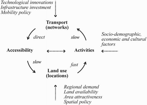
While certain interactions between LU and TINs (the right-hand side of the figure) have been the subject of several reviews in the past (see e.g. Ewing & Cervero, Citation2010), investigations of other interactions have been much more limited, especially those that are long term in nature. Very few papers take the full cycle into account, and it is the long-term impact of TINs on LU that is the key focus of this review paper (i.e. the left-hand side of the figure). In reviewing recent empirical literature, this paper considers whether LU development and its magnitude can be explained by TIN development (via accessibility), taking into account that both TIN and LU are also subject to a range of external factors.
A growth in empirical investigations of the long-term impacts of TINs has occurred over recent decades partly due to substantial improvements in the quality and availability of spatial TIN and LU data. It has also been aided by the availability of more sophisticated analytical techniques. For example, more sophisticated geographical information systems (GIS) allow the development and analysis of large, historical, spatial data sources, which then make it possible to track spatial changes in both TINs and LU more closely over time. High-resolution land-cover data sets derived from remote sensing techniques alongside digitised aerial photos or historic land surveys now provide researchers with a more detailed picture of change. Moreover, the application of econometric models has contributed to methodological improvements, such as instrumental variable estimations, which do not have a long history of application in quantitative studies (Atack, Bateman, Haines, & Margo, Citation2010). This advance in research methods has resulted in an emerging strand of literature interested in quantifying the long-term impact of TINs on LU or their interaction.
A key contribution of this paper is its focus on longer term impacts of TINS on LU (and vice versa), a wider geography of studies, different types of transport infrastructure (road and rail) and more recent evidence. The paper provides a broader perspective on previous reviews in the field (e.g. Badoe & Miller, Citation2000; Cervero & Seskin, Citation1995; Giuliano, Citation2004; Knight & Trygg, Citation1977).
1.1. Scope
While the main focus of this paper is the impact of TINs on LU, it also considers the interaction between the two, and whether and when TINs have followed LU development or vice versa. Both mono-directional studies (investigating the impact of TINs on LU) and bi-directional studies (investigating the impacts of TINs on LU and vice versa) are reviewed, with mono-directional studies representing the majority of the sample.
The paper reviews recent empirical studies originating from different parts of the world, which have considered the long-term impacts of TINs, both road and rail infrastructure, on LU. Demographic and spatial LU impacts of TINs, measured by changes in population and employment density, land cover and development type (residential, office, commercial, industrial) are reviewed, whereas economic outcomes measured by economic performance indicators such as the Gross Domestic Product (GDP) and property values are excluded (examined elsewhere by authors such as Banister & Berechman, Citation2001; Debrezion, Pels, & Rietveld, Citation2007). The focus on empirical findings means that ex-ante studies on land-use-transport modelling (LUT) are outside the scope of this paper (for an overview, see Iacono, Levinson, & El-Geneidy, Citation2008; Wegener, Citation2004).
All studies reviewed were published in peer-reviewed journals between 1995 and 2014. Because of the focus on the impacts of networks of transport infrastructure, studies of the impacts of small additions to TINs (e.g. a new metro station) are outside the scope of this review. Only studies with time spans of around a decade or more are included in this review. One reason for reviewing longer-term analyses is that they are more likely to capture the relatively slow development of LU arising from changes in TINs. Moreover, long-term observations make it possible to compare differences between various stages in history, which provides insights as to whether the LU impact of TINs has changed over time, as authors such as Giuliano (Citation1995) and Cervero and Seskin (Citation1995) have hypothesised. Evidence from several continents is compared in order to understand whether the results are general or regionally specific. A total of 49 studies were reviewed which originate from several regions across the world: USA (22 studies), Europe (21 studies) and Eastern Asia (6 studies).
The paper is divided into three main parts. Section 2 reviews the basic characteristics of the studies, including the stage in history examined, the time span, interval data frequency, spatial unit(s), study location, data types and indicators. Section 3 summarises the empirical findings of the studies reviewed. Section 4 provides the conclusion, proceeds with a discussion on a scheme which can explain the influence of TINs on LU over time and identifies new directions for future research in the field.
2. Study characteristics
2.1. Stage in history, time span and data interval
All articles reviewed in this paper are temporal in nature: they examine data at multiple points in time (i.e. multiple cross-sections). However, the studies vary in terms of three temporal dimensions: (i) the stage in history considered (e.g. the beginning or middle of the railway building era); (ii) the total time span examined (e.g. a decade or a century); and (iii) the frequency of data collected across the total time span (e.g. 5 or 10 year intervals). illustrates the variation between the 3 temporal dimensions in the 49 articles reviewed. The horizontal lines mark the length of the study period, the breaks representing the data intervals. Only the period in which the LU–TIN interactions are considered is depicted in the figure.
Figure 2. Stage in history, time span and data intervals of the papers reviewed.
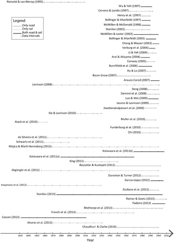
In general, the more recent studies, especially from Europe, investigate periods further back in time and with longer time spans, indicating a growing interest in long-term empirical analysis. The growth in long-term studies can partly be explained by advances in GIS techniques as well as the wider availability of high-resolution digital data and more sophisticated econometric techniques. Few studies examine data from earlier than 1950 (16 studies of 49) or consider time spans longer than 50 years (11 studies). The majority of studies (31) only investigate the impact of one type of TIN (i.e. either road or rail) on LU: only a minority (18) investigate both. The studies which go furthest back in time and start in the nineteenth century focus only on rail networks. Hardly any studies investigate the impacts of road infrastructure before 1950, probably because documenting historical road network evolution is very difficult in comparison to railway lines and stations. While a substantial amount of research has been done on the relation of rail and population change, the long-term role of access to rail in relation to employment and land-cover change has not often been considered. Almost all studies on land-cover change span the second half of the twentieth century.
Most studies focus on the second half of the twentieth century, especially the last few decades (). Studies which only focus on the impact of new TINs tend to have rather short time spans, such as the before–after impact study of the Bay Area Rapid Transit (BART) (Cervero & Landis, Citation1997). Studies concerned with urban growth usually look further back in time. Examples are those tracing the role of railways and earlier forms of public transport in population distribution patterns (Koopmans, Rietveld, & Huijg, Citation2012; Levinson, Citation2008).
2.2. Spatial unit and study area
The commonly used spatial units of analysis are census tracts, districts, municipalities or counties. Finer units of analysis, such as parcels and blocks or point location microdata, are usually aggregated into grid cells. A few studies employ other spatial units than administrative divisions or grid cells. For example, Cervero and Landis (Citation1997) and Bollinger and Ihlanfeldt (Citation1997) examine grid cells and tracts within station catchment areas, that is, a half-mile and quarter-mile ring of the stations. The total area of analysis (i.e. the area covered by all spatial units) in the studies ranges from a whole city region to a whole country. Studies with larger study areas tend to contain larger spatial units.
Studies at the regional and intraregional scales often differ in scope. Studies at the regional scale usually seek to demonstrate the effect of TINs on regional land development processes such as urbanisation or regional population/employment growth (and vice versa). The spatial units examined in these studies are often metropolitan areas, frequently across an entire country (e.g. Duranton & Turner, Citation2012). In terms of their scale and macro-economic approach, they are similar to studies investigating the relationship between transport infrastructure and economic productivity. Intraregional studies, on the other hand, investigate finer spatial units such as parcels and blocks, station areas, census tracts and districts/municipalities, often across a whole city region. These studies are frequently concerned with quantifying the more local changes in employment, residential and commercial densities and land covers within the region as a result of specific transport infrastructure projects.
2.3. Data types and indicators
Different data sources and indicators are used to examine LU and transport infrastructure. Most studies use population density as a proxy for LU, particularly those examining earlier stages in history. Some studies use the share of urban land as the indicator for LU development but generally only for the second half of the twentieth century when reliable data became available from satellite images and remote sensing techniques. This type of land-cover data is often available at intervals of 5–10 years either as raster (e.g. Demirel, Sertel, Kaya, & Seker, Citation2008) or manually digitised vectors based on aerial photos (e.g. Stanilov, Citation2003). In a smaller number of studies, the increase in the proportion of the population living in urban areas (i.e. urbanisation) was used as a proxy for LU change (Atack et al., Citation2010). Meanwhile, the work of Burchfield, Overman, Puga, and Turner (Citation2006) employed a measure of urban sprawl (i.e. the inverse of compactness of urban development) as an indicator of LU change. In general, studies of the impacts of TIN on LU in Eastern Asia cover more recent time periods, and focus on land-cover change rather than population growth (often due to data availability issues). In these cases, rapid land development combined with high-resolution recent data provides the opportunity to monitor change in detail. Only a few studies employ indicators for development type (residential, office, commercial, industrial) and intensity, using aggregated parcel attributes such as total floorspace. summarises the characteristics of the studies according to region, TIN type and LU type.
Table 1. Empirical studies of the impact on TIN on LU according to region, TIN type and LU type.
Various transport infrastructure indicators are used to measure the characteristics of transport modes including their length, the number/density of lines/stations and the distance to stations/highway exits. Distance is generally measured from the centroid of the unit of analysis (e.g. tract, municipality or grid cell) to the transport node (station, highway exit). Distances are mostly measured as straight-line (Euclidian) distances, except for a few cases where network distance was calculated (e.g. Giuliano, Redfearn, Agarwal, & He, Citation2012). Almost all studies use the concept of accessibility to analyse the LU transport interaction. Various measurements of accessibility are used, ranging from simple Euclidian distance through to more complex gravity-based indicators. In addition to physical and geographical measures, TIN investment indicators such as (per capita) expenditure on highway improvements have also been used.
3. Results of the studies
This section reports the main results of the studies in terms of the impact of rail and road networks on LU. summarises how many studies found significant results, positive or negative, or varying results with respect to different time intervals or different study areas. adds more detail by including the study period, region and specific LU characteristics.
Table 2. Summary of the main impacts of TINs on LU according to the studies reviewed.
Table 3. Summary of the results of the studies according to transport type and LU variables.
Models used for investigating population or employment change are quite varied. They include OLS, instrumental variable estimates, causality tests, Generalized Additive Models (GAMs) and experimental research designs such as Difference-in-differences. However, those determining land-cover change are quite straightforward, usually using logistic regression to model the probability of land conversion (e.g. from non-urban to urban or from one land type to the other) according to a variety of variables (e.g. Luo & Wei, Citation2009).
3.1. The impact of rail infrastructure on LU change
The development of railways has played a significant role in the spatial distribution of population in many countries. Akgüngör et al. (Citation2011) show that population growth along railway routes in Turkey was highly correlated with network development, especially up to 1940. Meanwhile, Beyzatlar and Kuştepeli (Citation2011), who focus on the impacts of rail infrastructure in the second half of the twentieth century, conclude that railway length had a short as well as a long-term impact on population density increase. In Portugal, da Silveira et al. (Citation2011) identify two phases for the impact of railway development on population growth up to 1930. Before 1911, the effect was strong as parishes with railway stations grew faster than those without, but after completion of railway network, it grew weaker. Similar relationships are reported by Mojica and Marti-Henneberg (Citation2011) for France, Spain and Portugal. They report that the urban areas connected to the rail network increased as the railways expanded up to the 1920s and decreased afterwards.
Impacts of railway development on population change can vary substantially across different territories in the same country. According to da Silveira et al. (Citation2011), more affluent regions in Portugal experienced population growth during the early development of the railways, whereas poorer regions experienced depopulation over the same period. Nevertheless, Schwartz et al. (Citation2011) report a positive impact in the less developed parts of south-west France in the 1800s. They also illustrate that railway density was significantly associated with reducing the pace of out-migration in rural areas in Wales and south-west England during the 1870s and 1880s. Looking at a longer period of time for the same region (1871–1931), Alvarez et al. (Citation2013) conclude that parishes most accessible to rail were most likely to experience population growth. Elsewhere in Oxfordshire (UK), Casson (Citation2013) finds negative, positive and no correlation between population growth and three respective waves of railway development (periods between 1831, 1861, 1891 and 1911). He suggests that different results can be related to the trunk lines built in the first and third waves (facilitating interurban traffic between larger cities rather than serving the intermediate towns) versus local lines serving the study area which were built during the second wave.
In a study of Finland, Kotavaara et al. (Citation2011b) conclude that proximity to railways significantly explained population growth from 1920 to 1970, except for the 1930s, coinciding with a decade of recession. In a separate study, they (Citation2011a) report that travel time to the nearest railway station was significantly related to population growth in 1970s but insignificant for the last decades of the twentieth century. In the period 2000–2007, the relationship between proximity to railway station and population growth became significant again, which they explain in terms of major government investments in long-distance transport infrastructure.
For a number of studies, the strength of the relation between rail and population change, as well as its rate, varies across different periods. Rietveld and van Nierop (Citation1995) explain the growth rate of 44 Dutch cities as a consequence of the growth of railways from 1840 to 1890. They note substantial changes in patterns of urban growth from decade to decade and report that the change in number of railway lines entering the cities is a modest but significant explanatory variable for a certain number of decades. The modest impact of rail on population growth is also confirmed by Koopmans et al. (Citation2012) who extend Rietveld and van Nierop’s study period by 40 years. Their “relative rail accessibility” indicator and its change (reflecting the change in shortest travel times between municipalities as a result of railway network improvements) show a significant and positive relation with municipal population growth during half a century coinciding with Dutch industrialisation (1880–1930). However, they conclude that this effect is small when compared to urbanisation (operationalised by “relative centrality” indicator which was only influenced by population distribution) and crowding effects (indicated as population density in persons per sq.km). Similarly, Atack et al. (Citation2010) confirm that the role of early railway network in population growth of American Midwest in the 1850s was not significant. However, railways were found to have significantly caused much of the increase in urbanisation, measured as the fraction of a county’s population living in urban areas.
At the city-region scale, it is suggested that rail can encourage the depopulation of the core while increasing the population in the periphery. For example, Levinson (Citation2008) reports that additional surface and underground rail stations are linked to the increase of population in the London periphery. Similarly, Garcia-Lopez (Citation2012) finds that improvements in the Barcelona’s metropolitan railway network were linked to suburban population growth between 1991 and 2006. In Chicago, McMillen and Lester (Citation2003) conclude that the proximity of a tract to commuter rail stations was associated with higher population density in the period between 1970 and 2000. On the other hand, Bollinger and Ihlanfeldt (Citation1997), report that the location of Atlanta’s MARTA (Metropolitan Atlanta Rapid Transit Authority) rail transit stations was not significantly related to patterns of population growth in the city during the 1980s.
Results on the relation between rail access and employment growth are mixed. For example, Cervero and Landis (Citation1997) show that growth in jobs in relation to BART has been mainly limited to downtown San Fransisco. On the other hand, Bollinger and Ihlanfeldt (Citation1997, Citation2003) find no rail impact on employment around MARTA’s station areas in the last decades of the twentieth century. Meanwhile, significant rail coefficients for employment density are reported around the same period for Chicago, a city with an established rail network (McMillen & Lester, Citation2003; McMillen & McDonald, Citation1998).
The indicator of land-cover change has been less frequently investigated than population density in studies of relationships between TINs and LU. The results of studies using indicators of land cover can be quite contradictory. Distance to railway line is reported to have no impact on land-cover change in Guangzhou from 1979 to 1992 (Wu & Yeh, Citation1997). Surprisingly, in the case of Nanjing (1988–2000), the proximity to rail is shown to discourage the conversion to urban land. Authors attribute this to the fact that rail does not support within-city displacements but serves “long-distance interurban” commutes (Luo & Wei, Citation2009). On the other hand, Cervero and Landis (Citation1997) illustrate that LU is significantly more likely to change in the proximity of BART stations.
Evidence was found that rail attracts residential developments. For example, Xie and Levinson (Citation2010) show that the growth of the streetcar network encouraged residential development in the Twin Cities of Minneapolis and St Paul between 1900 and 1930. Cervero and Landis (Citation1997) report that while multi-family housing grew rapidly around 25 BART stations, the major development belongs to non-residential LUs (i.e. commercial, office and industrial), particularly office space in downtown San Francisco. The rise of development (mostly residential but also non-residential such as offices) is also observed in station areas close to Downtown Denver from 1997 to 2010 (Ratner & Goetz, Citation2013).
3.2. The impact of road infrastructure on LU change
Most studies demonstrate that new road infrastructure, especially major road infrastructure, facilitates the relocation of population from the centre to the periphery (i.e. suburbanisation). Examining the impact of interstate highways on suburbanisation of US Metropolitan Statistical Areas between 1950 and 1990, Baum-Snow (Citation2007) reports that the improvements in the highway system attract population along the highways and contribute to the central city’s population decline. Meanwhile, Garcia-Lopez (Citation2012) concludes that the proximity to highway exits encouraged suburban population growth in the Barcelona Metropolitan Region between 1991 and 2006. Analysing the effect of roads on the growth of population in 275 Metropolitan Statistical Areas of continental USA between 1980 and 2000, Duranton and Turner (Citation2012) suggest that the increases in the major road stock can explain why some areas experienced higher population growth than others. Chi (Citation2010), examining the effects of highway “expansions” on population change in Wisconsin during the 1980s and 1990s, suggests that highway expansions mostly influenced population increase in suburban areas, thereby strengthening suburbanisation. On the other hand, Henry et al. (Citation1997) report that the initial stock of highways at 1980 was unrelated with population growth in rural hinterland tracts in South Carolina, Georgia and North Carolina during the 1980s. Meanwhile, McMillen and Lester (Citation2003) contend that population density growth between 1970 and 2000 was lower within a third of a mile of highway interchanges than other locations in the Chicago metropolitan area.
It is generally demonstrated that the road network, especially major road infrastructure, influence employment growth (a few studies, however, did not find this connection). Investigating the relation between highway road networks and employment in 48 contiguous US states between 1984 and 1997, Jiwattanakulpaisarn et al. (Citation2009) report that the density of lane-miles of non-local roads significantly explains the variations in employment growth in private sector. They conclude that the presence of an impact and its direction varies depending on the location (within the same state including the highway or all other states), time lag (short- or long-run impact) and type of highway (interstate highways or non-interstate major roads). According to a study by Giuliano et al. (Citation2012), highway network accessibility was significantly related to the growth of employment centres and urban spatial structure in the 1990s in the Los Angeles region. Examining the relation of specific highway improvement projects and employment change in three Californian counties from 1980 to 2000, Funderburg et al. (Citation2010) report that employment growth can be highly variable – both positive and negative. They conclude that the type of highway improvement (e.g. new extensions/connections or expanded capacity) can influence the overall impact on employment change as well as more location-specific characteristics, such as local economic performance or the degree of rurality. In their study of Chicago, McMillen and Lester (Citation2003) report that highways increasingly encouraged employment growth between 1970 and 2000. Meanwhile, Bollinger and Ihlanfeldt (Citation1997, Citation2003) demonstrate the same positive relation between presence of highways and per capita expenditures on them with employment growth in Atlanta for the periods of 1980–1990 and 1985–1997. Other studies, however, do not find evidence of a significant relation between highways and employment. Henry et al. (Citation1997), for example, conclude that the density of highways in 1980 was not a significant factor in attracting employment growth during the 1980s, and Arauzo-Carod (Citation2007) finds no significant relationship between TINs (road or rail) and the distribution of professional groups of population and workers across the territory.
Studies examining land-cover change conclude that the presence of or the proximity to the road network increases the likelihood of land-cover change in general, and the conversion from non-urban to urban (i.e. urbanisation) in specific. Using satellite images at roughly five year intervals from 1987 to 2001, Demirel et al. (Citation2008) show that the doubling of the road transport network coincides with an increase in urban areas and a decrease of barren and agricultural land in the southeast part of Istanbul Metropolitan Area. The results of Muller et al. (Citation2010) suggest that more urban development has taken place near motorway exits in Switzerland than further away, during the period 1985–1997. Mothorpe et al. (Citation2013) also report a link between the development of the interstate highway and the growth of urban areas in the counties of Georgia, USA, over the second half of the twentieth century. In Atlanta, Hu and Lo (Citation2007) report that the odds of urban development in close proximity to major roads nearly doubled in comparison to distances of more than one kilometre from the road network. Conway (Citation2005) finds the same significant relation between accessibility to highways, measured as the network distance to the nearest exit, and new urban development in New Jersey between 1986 and 1995. The proximity to the road infrastructure or its density is correlated to urban land development for various studies of China (Cheng & Masser, Citation2003; Deng et al., Citation2008; Li & Yeh, Citation2004; Wu & Yeh, Citation1997). Wu and Yeh (Citation1997) differentiate between road types and report that the magnitudes and signs of proximity to different road types changed before and after the Chinese land reform in 1987. Before land reform, proximity to inter-city highways located away from the centre increased the probability of land development. After reform, however, proximity to city streets encouraged the development of land, suggesting the attraction of new commercial developments to locations closer to city centres. The impact of the development of the road network on land-cover change varies by location according to studies such as Mothorpe et al. (Citation2013) who suggest that land cover is closely linked to the initial degree of urbanisation. Of their “urban”, “rural” and “transition” categories, only the “urban” counties show a significant growth of urban land as a result of interstate highway developments.
Various studies also indicate that highways attract commercial and/or industrial developments (Arai & Akiyama, Citation2004; Iacono & Levinson, Citation2009; Muller et al., Citation2010; Verburg et al., Citation2004), while supressing residential development (Cervero & Landis, Citation1997; Iacono & Levinson, Citation2009; McMillen & Lester, Citation2003). Measuring the impact of road network on LU distribution pattern within the suburban areas of Greater Seattle between 1960 and 1990, Stanilov (Citation2003) links the growth of residential and non-residential LUs to “integral accessibility”, an index based on access to the regional road network. LUs seeking most regionally accessible locations were commercial, followed by industrial, multi-family, medium-density single-family and finally low-density single-family uses.
3.3. The leading factor between TINs and LU
The number of bi-directional studies, which explore the interaction between LU and TIN, is relatively low in comparison to mono-directional studies of the impact of TIN on LU. According to several bi-directional studies, there is a view that TINs have followed LU, as in the case of early railways which followed the existing population cores (Atack et al., Citation2010), or the subways which followed the established residential development patterns in New York (King, Citation2011). Meanwhile, TINs are reported to have led LU in the case of electrified streetcars causing urbanisation in Twin Cities (Xie & Levinson, Citation2010). However, not all findings are clear-cut. For instance, Jiwattanakulpaisarn et al. (Citation2009) conclude that in the USA, causality between highways and regional employment could have happened in either direction, or Levinson (Citation2008) reports that rail station density and population density were mutually reinforcing in London periphery (Levinson, Citation2008).
3.4. The role of other factors
The impact of TINs on LU (and in general their interaction) depends to a considerable extent on exogenous factors which can influence their supply (). Major advances in TIN technology such as the emergence of railways or the electrification of tramways have been declared as a major driving force of LU change (e.g. Xie & Levinson, Citation2010). Infrastructure investments and transport policies influence the supply, but also the usage of TINs. Transport policies result directly in the investment in and the improvement of major TINs. For instance, King (Citation2011) indicates that the subway was initially planned to disperse high residential densities from downtown New York to the outer boroughs. Cervero and Landis (Citation1997) specify that BART was intended to encourage a multi-centred settlement pattern. In terms of LU impact, Kotavaara et al. (Citation2011a) claim that significant investments in the supply of long-haul rail transport in Finland influenced population distribution at a regional level in the 2000s. Furthermore, TINs are financed in a variety of ways which can affect LU decisions to various degrees. For example, the development potential of TINs can be fully exploited when transport developers have real estate interests and/or the legal authority to develop land (Xie & Levinson, Citation2010). On the other hand, when transport providers are not linked to the land development market and are dependent on fare revenues, only profitable routes within the existing built-up area are likely to be developed, and new TINs are unlikely to lead to new urban expansion (King, Citation2011).
Similarly, the final impact on LU can depend on exogenous factors influencing its supply. In the absence of regional demand, new TINs are unlikely to stimulate LU change. An example is that of railways encouraging growth in prosperous regions contrary to the lagging ones where they might even discourage further development (da Silveira et al., Citation2011). Furthermore, the availability of developable land as a prerequisite for TINs’ impact is demonstrated (e.g. Cervero & Landis, Citation1997). Surprisingly, area attractiveness has been mostly overlooked. An exception is Bollinger and Ihlanfeldt (Citation2003) who used crime rates as a proxy for area attractiveness and found that it can repel the positive impact of rail stations on employment. A minority of previous research has attempted to empirically measure the role of spatial policies. From those who have, the majority have focused only on the role of local policies, overlooking regional and national policies. China is an exceptional case where a radical and rapid change from a centrally planned to transitional economy (via economic and land reform) was observed, and its effect on the LU–TIN relationship was measured (Cheng & Masser, Citation2003; Wu & Yeh, Citation1997). In most cases, however, policy changes are less radical and more gradual, making it more difficult to quantify their effects. In an attempt to take the gradual change in planning policies into account, Chaudhuri and Clarke (Citation2014) used a quasi-experimental method to determine the role of “political history” (“the combination of regional level government programs and political events affecting urbanization pattern in a region”). They attribute the physical and structural differences between LU and TINs of two cities in the same region in Italy to the indirect result of various planning policies. The conclusion is that political history affected the LU and road-network changes separately, but not the type of spatial relationship between them.
Finally, in addition to separate transport and spatial policies, there are combined policies targeted at development of transit nodes under the umbrella term “Transit-oriented Development” or TOD policies. The main goal of such policies is to encourage high-density, mixed-use, pedestrian- and bicycle-friendly environments, in combination with improved transit systems to promote transit use (Bertolini, Curtis, & Renne, Citation2012; Cervero, Citation2007). Examples include rezoning, density bonuses, marketing of air rights and available excess land around transit nodes combined with level of service improvements, such as higher frequencies or speed. provides a list of the effects of spatial policies at the regional and local scale measured in the literature. A number of chosen examples demonstrate how they were operationalised and which results were obtained.
Table 4. Effects of LU and TIN policies measured in the reviewed studies.
4. Conclusions, discussion and recommendations for future research
4.1. Conclusions on the effects of transport infrastructure on LU change
This paper has systematically reviewed the long-term influences of TINs, both road and rail, on LU. It investigated how LU is likely to change as a result of the development of different TINs over time, and the role of external factors including policies in this respect. Its specific contribution to the field is threefold. First, it provides a synthesis of the most recent empirical evidence from studies published since 1995. Second, it reviews and compares empirical evidence from different parts of the world – USA, Europe and Asia. Third, it focuses specifically on the long-term impacts of TINs on LU, as opposed to short-term impacts.
Proximity to rail is generally considered to have influenced population distribution, especially after the railway network emergence. Exceptional negative effects were reported for lagging regions, trunk lines which were not beneficial to the local study area, or areas which already had a dense rail service for a while. Proximity to rail has also promoted conversion to residential LU and development of higher residential densities. However, findings on its role in increasing employment density are inconclusive, indicating that its success is more dependent on exogenous factors such as complementary policies and area attractiveness, which are mostly favourable in downtown areas.
For the road network, studies generally suggest that the presence of or the proximity to major highways is associated with the conversion to urban land, increases in employment densities and commercial and industrial development. However, this is not always the case for residential uses, suggesting that living in the direct vicinity of motorways could be unattractive.
Of the 19 studies which have examined both access to rail and road networks, almost all of them find lower coefficients or no significance for access to rail compared to the road network, regardless of the study period. However, it should be noted that these studies mostly focus on changes during the second half of the twentieth century and onwards, when the rail network is assumed to have lost its initial impact.
Exogenous factors influencing the supply of TINs and LU can determine the result of TINs on LU. Technological innovations, infrastructure investments and mobility policies influence the supply of TINs. In terms of LU, regional demand, land availability, area attractiveness and spatial policy play important roles. While these factors have been mentioned, they have not always been explicitly addressed. This is especially true in the case of area attractiveness and spatial/transport policies.
4.2. Discussion
Formulating clear-cut conclusions on the impacts of TINs on LU with a focus on their relation over time needs care because of the variety of methods, data sources, spatial and temporal scales, physical locations and findings (see Deng, Citation2013 for an extensive review of potential causes behind inconclusive results in the study of TINs’ economic impacts which can also be applied to their LU impacts). Nevertheless, a simple scheme for illustrating the relationships over time can be used to summarise the general situation (). The horizontal and vertical axes in the table represent the degree of development of LU and TIN, respectively. In practice, these axes are continuous but are represented in binary form in for simplicity of presentation.
Table 5. Importance of saturation level of TINs and LU on the impacts of the transport system on LU.
In terms of TINs, there is a threshold after which their accessibility improvement and consequently LU impacts become increasingly marginal (Axhausen, Citation2008; Giuliano, Citation2004). This trend can be observed in the case of the impacts of rail on LU, which follows a logistic function. Non-significant coefficients for access to rail variables have been reported at the beginning of the development of the railway network (when the impact has not yet had effect) and in more recent decades (when the impact has worn off). For the period in between, more significant results were reported. In the case of road network, its initial impact is less clear due to the lack of studies which consider the situation before 1950. Nevertheless, the saturation in accessibility provided by the road network is observable in the case of the weakening effect of highway developments after the era of highway building.
Similarly, there is also a development threshold after which LU change (e.g. conversion from non-urban to urban, rise in population density, stock of housing and other buildings) slows down. In other words, just as land development increases so do constraints for further development. Further TIN improvements are unlikely to yield significant LU changes when there is no space for development, mainly due to the durability of the built-environment and the high costs of demolishing and reconstructing an already developed area. On the whole, the magnitude of TINs’ impact on LU depends on the stage of TIN development coinciding with the stage of LU development.
Regarding the leading factor between TINs and LU, the number of bi-directional studies is too small to draw definitive conclusions for the time being. However, the findings suggest that the more developed of the two is likely to have the upper hand in leading the other’s development, unless a significant advance in transport technology or an effective policy intervention occurs which succeeds in setting a new trend. In other words, whether it is TIN or LU which leads seems to be closely related to the concurrence of TIN and LU saturation stages as well. indicates the possible leading factors at each stage in addition to the likely extent of LU impact.
4.3. Recommendations for future research
Although there are many papers on the relationship between TINs and LU, certain issues have only scarcely been addressed. These issues are reflected in the following recommendations for future research:
Current literature mainly focuses on direct impacts of TIN development on LU; however, the same developments may also affect other spatial levels, a phenomenon referred to as spatial spillovers. The existence of TINs’ impact, its type and significance can vary at different spatial scales. Positive spillover effects emerge from the network behaviour of TINs. For instance, a new highway link not only affects the locations it directly connects, but also influences a wider region by reducing the overall travel cost and increasing the overall accessibility (Giuliano, Citation2004). Conversely, TIN modifications could also change the comparative advantage of different regions to attract productive resources (e.g. labour force) and entail negative spillover effects (Boarnet, Citation1998; Deng, Citation2013). An example is a highway increasing employment in the states it directly passes through at the expense of other states (Jiwattanakulpaisarn et al., Citation2009). Thus, the extent to which TIN investments can redistribute LU changes across jurisdictions and over larger distances calls for closer investigation.
TINs have impact not only on LU but also on economic (see e.g. Aschauer, Citation1989; Lakshmanan, Citation2011; Munnell, Citation1990), environmental and social domains (Geurs, Boon, & Van Wee, Citation2009). To assess the overall impact of TINs, these strands of research need to be compared.
The length of the study (time span) should be long enough to capture potential impacts (bi-directional studies need longer investigation periods than mono-directional ones). Also, data intervals during this time span should be frequent enough to test the effect of different time periods.
The degree of saturation of TIN-provided accessibility and LU (i.e. whether and to what extent TINs and LU have evolved during the study period) should be measured. There is a need to explore indicators which can capture the effect of change in TIN-provided accessibility over time. These indicators should take account not only of the network characteristics of transport infrastructure but also of LU constraints.
The role of new transit in attracting or repelling employment in different sectors and the magnitude of change in land cover and type of development (residential/commercial/offices) at different proximities to the station areas require closer examination, especially in the European and Asian context. Such studies could help to increase understanding of the feasibility of public transit investments and the possibility of success of planning concepts such as Transit-Oriented Development and Smart Growth.
As well as improving accessibility (which directly influences LU), TINs (especially transit) can influence LU indirectly by inducing complementary policies. Under conditions of saturated accessibility and LU development, research focusing purely on the role of TIN-related accessibility on LU patterns is unlikely to find significant results. In order to identify policy effects, future research should compare TIN–LU interactions across a variety of regions and time periods. An alternative is to carry out in-depth case-study research, which can shed light on the various local and context-specific mechanisms at work. Special attention should be given to the role of transport policies which can improve the quality of transport services (e.g. increasing frequencies and travel speeds, subsidies for transit fares or restrictive parking) rather than simply the existence of infrastructure.
Including the role of area attractiveness is necessary to explain non-significant or negative TIN results as well as their positive impact. This will involve the use of more socio-economic and context-specific data such as education, income, crime profiles of the study area, as well as physical condition of the building stock and other civil infrastructures.
The studies reviewed in this paper have analysed the impact of new or additional TINs on LU and not the impact of removed TINs on future LU. According to Block-Schachter and Zhao (Citation2015), the impact of TINs on LU may continue even after the transport network has been removed. However, their theory of “hysteresis” requires further empirical investigation.
Finally, studies focusing on one side of the LU transport feedback cycle will inherently be subject to the problem of endogeneity because the feedback between the two is not considered. There is an increasing need for bidirectional studies which investigate the interaction and the leading factor between TINs and LU and how they might differ over various periods and scales. Fortunately, such investigations are increasingly possible due to the wider availability of long-term, high-resolution data and new methods for their analysis.
Disclosure statement
No potential conflict of interest was reported by the authors.
ORCID
Kees Maat http://orcid.org/0000-0002-7832-7017
Dominic Stead http://orcid.org/0000-0002-8198-785X
Additional information
Funding
References
- Akgüngör, S., Aldemir, C., Kustepeli, Y., Gulcan, Y., & Tecim, V. (2011). The effect of railway expansion on population in Turkey, 1856–2000. Journal of Interdisciplinary History, 42(1), 135–157.
- Alvarez, E., Franch, X., & Marti-Henneberg, J. (2013). Evolution of the territorial coverage of the railway network and its influence on population growth: The case of England and Wales, 1871–1931. Historical Methods: A Journal of Quantitative and Interdisciplinary History, 46(3), 175–191. doi:10.1080/01615440.2013.804788
- Arai, T., & Akiyama, T. (2004). Empirical analysis for estimating land use transition potential functions—case in the Tokyo metropolitan region. Computers, Environment and Urban Systems, 28, 65–84.
- Arauzo-Carod, J. M. (2007). Determinants of population and jobs at a local level. Annals of Regional Science, 41(1), 87–104. doi:10.1007/s00168-006-0058-6
- Aschauer, D. A. (1989). Is public-expenditure productive. Journal of Monetary Economics, 23(2), 177–200. doi:10.1016/0304-3932(89)90047-0
- Atack, J., Bateman, F., Haines, M., & Margo, R. A. (2010). Did railroads induce or follow economic growth? Urbanization and population growth in the American Midwest, 1850–1860. Social Science History, 34(2), 171–197. doi:10.1215/01455532-2009-024
- Axhausen, K. (2008). Accessibility: Long-term perspectives. Journal of Transport and Land Use, 1(2), 5–22. doi:10.5198/jtlu.v1i2.66
- Badoe, D. A., & Miller, E. J. (2000). Transportation-land-use interaction: empirical findings in North America, and their implications for modeling. Transportation Research Part D-Transport and Environment, 5(4), 235–263. doi:10.1016/S1361-9209(99)00036-X
- Banister, D., & Berechman, J. (2001). Transport investment and the promotion of economic growth. Journal of Transport Geography, 9, 209–218.
- Baum-Snow, N. (2007). Did highways cause suburbanization? Quarterly Journal of Economics, 122(2), 775–805. doi:10.1162/qjec.122.2.775
- Bertolini, L. (2012). Integrating mobility and urban development agendas: A manifesto. Disp - The Planning Review, 48(1), 16–26.
- Bertolini, L., Curtis, C., & Renne, J. (2012). Station area projects in Europe and beyond: Towards transit oriented development? Built Environment, 38(1), 31–50.
- Beyzatlar, M. A., & Kuştepeli, Y. (2011). Infrastructure, economic growth and population density in Turkey. International Journal of Economic Sciences and Applied Research, 4(3), 39–57.
- Block-Schachter, D., & Zhao, J. H. (2015). Hysteresis & urban rail. European Journal of Transport and Infrastructure Research, 15(1), 78–91.
- Boarnet, M. G. (1998). Spillovers and the locational effects of public infrastructure. Journal of Regional Science, 38(3), 381–400. doi:10.1111/0022-4146.00099
- Bollinger, C. R., & Ihlanfeldt, K. R. (1997). The impact of rapid rail transit on economic development: The case of Atlanta’s MARTA. Journal of Urban Economics, 42(2), 179–204. doi:10.1006/juec.1996.2020
- Bollinger, C. R., & Ihlanfeldt, K. R. (2003). The intraurban spatial distribution of employment: Which government interventions make a difference? Journal of Urban Economics, 53(3), 396–412. doi:10.1016/S0094-1190(03)00007-X
- Burchfield, M., Overman, H. G., Puga, D., & Turner, M. A. (2006). Causes of sprawl: A portrait from space. Quarterly Journal of Economics, 121(2), 587–633. doi:10.1162/qjec.2006.121.2.587
- Casson, M. (2013). The determinants of local population growth: A study of Oxfordshire in the nineteenth century. Explorations in Economic History, 50(1), 28–45. doi:10.1016/j.eeh.2012.09.003
- Cervero, R. (2007). Transit-oriented development’s ridership bonus: A product of self-selection and public policies. Environment and Planning A, 39(9), 2068–2085. doi:10.1068/a38377
- Cervero, R., & Landis, J. (1997). Twenty years of the Bay area rapid transit system: Land use and development impacts. Transportation Research Part A-Policy and Practice, 31(4), 309–333. doi:10.1016/S0965-8564(96)00027-4
- Cervero, R., & Seskin, S. (1995). An evaluation of the relationships between transit and urban form. Retrieved from Transit Cooperative Research Program, Research Results Digest 7.
- Chaudhuri, G., & Clarke, K. C. (2014). On the spatiotemporal dynamics of the coupling between land use and road networks: Does political history matter? Environment and Planning B: Planning and Design, 41. doi:10.1068/b39089
- Cheng, H. Q., & Masser, I. (2003). Urban growth pattern modeling: A case study of Wuhan city, PR China. Landscape and Urban Planning, 62(4), 199–217.
- Chi, G. Q. (2010). The impacts of highway expansion on population change: An integrated spatial approach. Rural Sociology, 75(1), 58–89.
- Conway, T. M. (2005). Current and future patterns of land-use change in the coastal zone of New Jersey. Environment and Planning B-Planning & Design, 32(6), 877–893. doi:10.1068/B31170
- Debrezion, G., Pels, E., & Rietveld, P. (2007). The impact of railway stations on residential and commercial property value: A meta-analysis. Journal of Real Estate Finance and Economics, 35(2), 161–180. doi:10.1007/s11146-007-9032-z
- Demirel, H., Sertel, E., Kaya, S., & Seker, D. Z. (2008). Exploring impacts of road transportation on environment: A spatial approach. Desalination, 226(1–3), 279–288. doi:10.1016/j.desal.2007.02.111
- Deng, T. (2013). Impacts of transport infrastructure on productivity and economic growth: Recent advances and research challenges. Transport Reviews, 33(6), 686–699. doi:10.1080/01441647.2013.851745
- Deng, X. Z., Huang, J. K., Rozelle, S., & Uchida, E. (2008). Growth, population and industrialization, and urban land expansion of China. Journal of Urban Economics, 63(1), 96–115. doi:10.1016/j.jue.2006.12.006
- Duranton, G., & Turner, M. A. (2012). Urban growth and transportation. Review of Economic Studies, 79(4), 1407–1440. doi:10.1093/restud/rds010
- Ewing, R., & Cervero, R. (2010). Travel and the built environment. Journal of the American Planning Association, 76(3), 265–294.
- Franch, X., Morillas-Torne, M., & Marti-Henneberg, J. (2013). Railways as a factor of change in the distribution of population in Spain, 1900–1970. Historical Methods, 46(3), 144–156. doi:10.1080/01615440.2013.803414
- Funderburg, R. G., Nixon, H., Boarnet, M. G., & Ferguson, G. (2010). New highways and land use change: results from a quasi-experimental research design. Transportation Research Part A-Policy and Practice, 44(2), 76–98. doi:10.1016/j.tra.2009.11.003
- Garcia-Lopez, M. A. (2012). Urban spatial structure, suburbanization and transportation in Barcelona. Journal of Urban Economics, 72(2–3), 176–190. doi:10.1016/j.jue.2012.05.003
- Geurs, K., Boon, W., & Van Wee, B. (2009). Social impacts of transport: Literature review and the state of the practice of transport appraisal in the Netherlands and the United Kingdom. Transport Reviews, 29(1), 69–90.
- Giuliano, G. (1995). The weakening transportation-land use connection. ACCESS Magazine, University of California Transportation Center, UC Berkeley.
- Giuliano, G. (2004). Land use impacts of transportation investments; highway and transit. In S. Hanson & G. Giuliano (Eds.), The geography of urban transportation (pp. 237–273). New York: Guilford Press.
- Giuliano, G., Redfearn, C., Agarwal, A., & He, S. (2012). Network accessibility and employment centres. Urban Studies, 49(1), 77–95. doi:10.1177/0042098011411948
- Henry, M. S., Barkley, D. L., & Bao, S. M. (1997). The hinterland’s stake in metropolitan growth: Evidence from selected southern regions. Journal of Regional Science, 37(3), 479–501. doi:10.1111/0022-4146.00065
- Hu, Z. Y., & Lo, C. P. (2007). Modeling urban growth in Atlanta using logistic regression. Computers, Environment and Urban Systems, 31(6), 667–688. doi:10.1016/j.compenvurbsys.2006.11.001
- Iacono, M., & Levinson, D. (2009). Predicting land use change how much does transportation matter?. Transportation Research Record, 2119, 130–136. doi:10.3141/2119-16
- Iacono, M., Levinson, D., & El-Geneidy, A. (2008). Models of transportation and land use change: A guide to the territory. Journal of Planning Literature, 22(4), 323–340. doi:10.1177/0885412207314010
- Jiwattanakulpaisarn, P., Noland, R. B., Graham, D. J., & Polak, J. W. (2009). Highway infrastructure and state-level employment: A causal spatial analysis. Papers in Regional Science, 88(1), 133–159. doi:10.1111/j.1435-5957.2008.00205.x
- King, D. (2011). Developing densely; estimating the effect of subway growth on New York City land uses. The Journal of Transport and Land use, 4(2), 19–32.
- Knight, R. L., & Trygg, L. L. (1977). Evidence of land-use impacts of rapid transit systems. Transportation, 6(3), 231–247.
- Koopmans, C., Rietveld, P., & Huijg, A. (2012). An accessibility approach to railways and municipal population growth, 1840–1930. Journal of Transport Geography, 25, 98–104. doi:10.1016/j.jtrangeo.2012.01.031
- Kotavaara, O., Antikainen, H., & Rusanen, J. (2011a). Population change and accessibility by road and rail networks: GIS and statistical approach to Finland 1970–2007. Journal of Transport Geography, 19(4), 926–935. doi:10.1016/j.jtrangeo.2010.10.013
- Kotavaara, O., Antikainen, H., & Rusanen, J. (2011b). Urbanization and transportation in Finland, 1880–1970. Journal of Interdisciplinary History, 42(1), 89–109.
- Lakshmanan, T. R. (2011). The broader economic consequences of transport infrastructure investments. Journal of Transport Geography, 19(1), 1–12. doi:10.1016/j.jtrangeo.2010.01.001
- Levinson, D. (2008). Density and dispersion: the co-development of land use and rail in London. Journal of Economic Geography, 8(1), 55–77. doi:10.1093/Jeg/Lbm038
- Li, X., & Yeh, A. G. O. (2004). Analyzing spatial restructuring of land use patterns in a fast growing region using remote sensing and GIS. Landscape and Urban Planning, 69(4), 335–354. doi:10.1016/j.landurbplan.2003.10.033
- Luo, J., & Wei, Y. H. D. (2009). Modeling spatial variations of urban growth patterns in Chinese cities: The case of Nanjing. Landscape and Urban Planning, 91(2), 51–64. doi:10.1016/j.landurbplan.2008.11.010
- McMillen, D. P., & Lester, T. W. (2003). Evolving subcenters: Employment and population densities in Chicago, 1970–2020. Journal of Housing Economics, 12(1), 60–81. doi:10.1016/S1051-1377(03)00005-6
- McMillen, D. P., & McDonald, J. F. (1998). Suburban subcenters and employment density in metropolitan Chicago. Journal of Urban Economics, 43(2), 157–180. doi:10.1006/juec.1997.2038
- Mojica, L., & Marti-Henneberg, J. (2011). Railways and population distribution: France, Spain, and Portugal, 1870–2000. Journal of Interdisciplinary History, 42(1), 15–28.
- Mothorpe, C., Hanson, A., & Schnier, K. (2013). The impact of interstate highways on land use conversion. Annals of Regional Science, 51(3), 833–870. doi:10.1007/s00168-013-0564-2
- Muller, K., Steinmeier, C., & Kuchler, M. (2010). Urban growth along motorways in Switzerland. Landscape and Urban Planning, 98(1), 3–12. doi:10.1016/j.landurbplan.2010.07.004
- Munnell, A. H. (1990). Why has productivity growth declined? Productivity and public investment. New England Economic Review, 30(January), 2–22.
- Padeiro, M. (2013). Transport infrastructures and employment growth in the Paris metropolitan margins. Journal of Transport Geography, 31, 44–53. doi:10.1016/j.jtrangeo.2013.05.007
- Ratner, K. A., & Goetz, A. R. (2013). The reshaping of land use and urban form in Denver through transit-oriented development. Cities, 30, 31–46. doi:10.1016/j.cities.2012.08.007
- Rietveld, P., & van Nierop, J. (1995). Urban growth and the development of transport networks: the case of the Dutch railways in the nineteenth century. Flux, 19, 31–43.
- Schwartz, R., Gregory, I., & Thevenin, T. (2011). Spatial history: Railways, uneven development, and population change in France and Great Britain, 1850–1914. Journal of Interdisciplinary History, 42(1), 53–88.
- da Silveira, L. E., Alves, D., Lima, N. M., Alcantara, A., & Puig, J. (2011). Population and railways in Portugal, 1801–1930. Journal of Interdisciplinary History, 42(1), 29–52.
- Stanilov, K. (2003). Accessibility and land use: The case of suburban Seattle, 1960–1990. Regional Studies, 37(8), 783–794. doi:10.1080/0034340032000128712
- Stanilov, K. (2013). Planning the growth of a metropolis: Factors influencing development patterns in West London, 1875–2005. Journal of Planning History, 12(1), 28–48. doi:10.1177/1538513212454813
- Verburg, P. H., van Eck, J. R. R., de Nijs, T. C. M., Dijst, M. J., & Schot, P. (2004). Determinants of land-use change patterns in the Netherlands. Environment and Planning B-Planning & Design, 31(1), 125–150. doi:10.1068/B307
- Wegener, M. (2004). Overview of land-use transport models. In D. A. Hensher & K. Button (Eds.), Transport geography and spatial systems (pp. 127–146). Kidlington: Pergamon/Elsevier Science.
- Wegener, M., & Fürst, F. (1999). Land-use transport interaction: State of the art. Deliverable D2a of the project TRANSLAND (Integration of transport and land use planning). Dortmund: University of Dortmund.
- Wu, F. L., & Yeh, A. G. O. (1997). Changing spatial distribution and determinants of land development in Chinese cities in the transition from a centrally planned economy to a socialist market economy: A case study of Guangzhou. Urban Studies, 34(11), 1851–1879. doi:10.1080/0042098975286
- Xie, F., & Levinson, D. (2010). How streetcars shaped suburbanization: A granger causality analysis of land use and transit in the twin cities. Journal of Economic Geography, 10(3), 453–470. doi:10.1093/Jeg/Lbp031