
ABSTRACT
The utilisation of data and technology in transportation has given rise to new forms of flexible, on-demand mobility and urban freight services. Such advances have also enabled the integration of multiple transportation modes and facilitated more predictable, environmentally-friendly, high-volume trips. While many of these technologies are now commonplace in higher income cities, they are less prevalent in lower income cities. This review identifies a) recent advances in technology and data that can facilitate multimodal urban travel, and b) the existing and potential application of these advances in low- and lower middle-income (LIC and LMIC) cities, particularly in Sub-Saharan Africa and Asia. This review examines peer-reviewed and grey literature and uses a multi-method approach with expert interviews. The review identifies open transportation data and data standards, global positioning systems, cashless fare payment, and blockchain as having high potential to facilitate integrated mobility in lower income contexts, and considers potential barriers to adopting and risks of utilising these technologies in LICs and LMICs. The review finds that, enabled by technology and data advances, LICs and LMICs could leapfrog the high car use and inefficient urban freight systems typical of higher income cities to more integrated, efficient, multimodal transport systems.
1. Introduction
Growth in private car use in the last half-century has increased the speed and comfort of travel. This has come at the expense of the use of sustainable modes, including public transportation, walking, and cycling, and has incurred considerable societal costs in terms of public health (e.g. traffic fatalities) and the environment, including local air pollution and the emission of greenhouse gases (Kemp, Geels, & Dudley, Citation2012). Alternatively, physical, informational, payment, and operational integration between non-car modes can create more seamless, user-focused passenger trips and more efficient urban freight delivery (Willing, Brandt, & Neumann, Citation2017). Integrated transportation systems – ones in which public and private transport, cycling, and walking create a cohesive network – promote sustainability and livability in urban settings by reducing demand for privately owned vehicles (Saliara, Citation2014).
Such integrated systems support ‘high volume transport’ (HVT): policies, infrastructure, and services that improve access to destinations in a way that enhances safety, addresses inequity, minimises environmental impact, and uses resources efficiently. While a number of transport modes can be integrated, this review considers a subset that has the greatest potential to support HVT. These include space-efficient, low- and no-carbon vehicles, such as personal and shared bicycles and electric scooters, shared transportation (e.g. rickshaws), and public transportation such as buses or trains. While we include automobile ridesourcing (e.g. Uber and Lyft) as a data and technology innovation that can facilitate multimodal travel, we also note potential negative effects of this mode on overall mobility (detailed in Section 5).
This paper reviews literature about data and technology innovations adopted primarily in high-income contexts and explores the extent to which these could be adopted in LIC and LMICs (World Bank, Citation2018).Footnote1 It also explores barriers to, and benefits from, applications in the latter contexts. A small body of literature exists on the use of recent technology and data innovations to support transport integration (which we also refer to as ‘integrative technologies’) in cities in high- and upper middle-income countries (HICs and UMICs). The extent to which the impacts of integrative technologies on travel behaviour and demand have been documented and analysed in low-income contexts is limited.
This paper is structured as follows: Section Two provides context for the evolution of integrated mobility and challenges present in LICs and LMICs. Section Three describes how literature was selected and reviewed. Section Four introduces recent technological and data innovations, their use in transport integration in high-income cities, and their existing or potential application in low-income cities. Section Five discusses cross-cutting barriers to adoption and risks for implementation and management, as well as potential benefits. Section Six discusses the literature and presents opportunities for future research.
This paper uses terminology that may not appear in standard dictionaries. includes definitions of such terms which are not defined elsewhere in the text.
Table 1. Definitions
2. Context: transport data and technology innovations in HICs & LICs
Rapid urban growth, motor vehicle ownership, sprawl, and historical land uses limit access to destinations and opportunities by restricting the convenience, affordability, and availability of multimodal travel (Cervero, Citation2013; Ann, Jiang, Mothafer, & Yamamoto, Citation2019). However, technology-enabled solutions such as mobile phones, global positioning systems (GPS), and electronic and mobile payments can expand access to high-quality urban travel (Bąk & Borkowski, Citation2015) by improving service information and reliability, addressing gaps in transit access, and allowing for more predictable connections between modes and to destinations (Willing et al., Citation2017). These developments have also given rise to on-demand mobility including ridesourcing, bikesharing, carsharing, and on-demand freight across all types of cities (Aliança Bike, Citation2019; Fishman, Citation2016; Jin, Kong, Wu, & Sui, Citation2018; Kawaguchi, Tsumura, Danno, & Kuwahara, Citation2017; Lenoir & Laplace, Citation2017; Mindur, Turoń, & Sierpiński, Citation2018).
In general, intelligent transport systems (ITS) have been adopted at a moderate pace in high-income settings, and more gradually in LICs and LMICs (Pojani & Stead, Citation2015). However, technology-enabled, on-demand mobility services, namely ridesourcing, has seen more rapid adoption in Africa and Southeast Asia in recent years, especially with the emergence of local firms (GSMA, Citation2019a, Citation2019b). Many major firms including Grab and Ola, which originated in Malaysia in 2014 and India in 2015 respectively, still hold significant market shares in 2018 (see ). Some newer local firms such as Gojek have become regional competitors.
Table 2 . Leading ridesourcing companies in LICs and LMICs by region.
The otherwise slow uptake of technology-enabled mobility in low-capacity settings is inextricably linked to the digital divide, which Ferro, Helbig, and Gil-Garcia (Citation2011) defines as: differences in access to modern communications technologies, and the breadth of knowledge and information those technologies disseminate, based on regional or demographic factors. Access to (non-smart) mobile phones and service in sub-Saharan Africa has grown rapidly since the early 2000s; 82 out of 100 people in sub-Saharan Africa had cellular subscriptions as of 2018 (World Bank, Citationn.d.). Internet data packages and mobile smartphones, however, remain expensive in LIC and LMIC cities (West, Citation2015).
Internet access is also limited, especially outside of major urban centres. As of 2016, South Africa had the highest percentage of the population with access to the internet in sub-Saharan Africa at 52%, followed by Nigeria at 46% (Internet Users by Country, 2016, Citationn.d.). However, nearly half of the 48 countries that make up sub-Saharan Africa have fewer than 15% of their population with internet access (Internet Users, 2016, Citationn.d.). Connectivity issues such as slow speeds and dropped connections further complicate the ability to reliably access the internet (Woodhouse & Thakur, Citation2018).
These access barriers can limit the use of ITS elements in some cases, particularly those developed for smartphones. However, widespread reliance on non-smart mobile phones in LICs and LMICs has led to the emergence of locally-generated solutions which internalise and capitalise on existing conditions and accelerate success by anticipating barriers and costs (Adriaens, De Lange, & Zielinski, Citation2013). Such alternatives could enable LIC and LMIC cities to leapfrog – which occurs when newer technologies provide market entry opportunities for latecomers that allow the latter to skip certain trial and error phases – HIC and UMIC cities in terms of transport integration (Blanco & Moudon, Citation2017; Sultana, Salon, & Kuby, Citation2019). For example, many African cities successfully leapfrogged landline phone technology – which was costly and complex to install in HICs – for mobile phones in the early 2000s (Aker & Mbiti, Citation2010).
3. Materials and methods
This paper uses a multi-method approach guided by Van Wee and Banister’s (Citation2016) overview of methods and procedures for literature reviews, as well as by Durach, Kembro, and Wieland (Citation2017) and Morris, Onwuegbuzie, and Gerber (Citation2018). We combine the method for systematic literature reviews described by the former authors with the approach outlined by the latter, which integrates qualitative methods. Schulenkorf, Sherry, and Rowe (Citation2016) note that multi-method or ‘integrative reviews’ are complex, highly comprehensive, and play an increasing role in providing the foundation to develop policy, practice, and research.
Our review process followed the six steps for systematic literature reviews defined by Durach et al. (Citation2017) and shown in .
Figure 1. Steps to Conduct a Systematic Literature Review as Defined by Durach et al. (Citation2017)
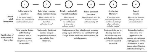
We began by defining the topic of our review which, broadly, covers data and technology in transportation. Technology, in the context of this paper, aligns with what has been defined as integrated ITS elements, which include platforms that communicate real-time travel information to users, on-demand technology-enabled mobility services, demand-responsive parking, and predictive traffic management systems (Pojani & Stead, Citation2015).
In step two, we defined characteristics for including or excluding sources: This review is not comprehensive of all recent developments in technology and data, as some have only recently been implemented in limited HIC contexts (e.g. mobility as a service pilots, passenger vehicle automation), or do not directly facilitate physical, informational, operational, or payment integration (e.g. electrification, alternative fuel technologies, drone technology for surveying). This review does not focus on clean propulsion technologies (e.g. electric cars) because they do not themselves facilitate better integrated HVT. Similarly, we chose to exclude technologies used to reduce demand for private car use, such as those that facilitate dynamic parking pricing and road use pricing, because they do not, on their own, address transport integration. Also not included are technology-enabled platforms like Safetipin, which aims to improve safety conditions in public spaces including public transport through knowledge sharing, but which does not directly enable integration towards HVT.
Next, we deviated slightly from Durach et al. (Citation2017) and conducted steps three and four simultaneously. We reviewed literature on technology-enabled mobility solutions gathered for the High Volume Transport Theme Two report (referred to as the ‘DFID report’ in this paper), prepared by the Institute for Transportation and Development Policy (ITDP) for the Department for International Development (DFID). This search included articles on the integrative elements of mobility as a service (MaaS) platforms; technology and data innovations that support transport integration; emerging business, financing, and policy models enabling implementation; and efforts to develop multi-stakeholder forums. One-hundred and sixteen sources were considered, and approximately 90 sources were selected for use. This process began in August 2018 and concluded in January 2019.
This initial phase also included expert interviews. Due to the rapidly evolving nature of the field, we consulted with 20 experts including academic researchers (n=10), public sector and NGO practitioners (n=5), and private sector professionals (n=5) with specialised knowledge on data and technology in transportation (six work primarily in LICs and LMICs). The interviews ultimately helped identify literature for inclusion in this review, fill in research gaps, provide a more comprehensive perspective on the topics, and validate initial findings. Our experience aligned with the literature, which finds that multi-method reviews using expert interviews can provide a layer of richness that may not be available in published materials (Morris et al., Citation2018). Expert interviews have been used successfully in reviews in a wide range of fields (Morris et al., Citation2018) including transportation (Beck, Citation2011; Shaheen & Chan, Citation2016).
A narrow scan of the 90 sources used in the DFID report resulted in approximately 20 sources utilised in this paper. This literature focused specifically on the technology-enabled solutions we examine: open data, data standards, GPS, cashless payment technologies, and blockchain and their applications toward better-integrated HVT systems. We also included sources that discuss barriers and benefits to technology transfer in LICs. This phase concluded in July 2019.
We then searched Google Scholar and Scopus to identify literature covering topics in more detail compared to the DFID report. We found approximately 100 additional sources; 50 were used in the review. The research was conducted in English, and the date range was 2007-2019. We chose 2007 as a starting point as it was the publication date of a broad review that included information technology for transportation and other ITS technologies (Banister & Stead, Citation2007). However, due to the rapidly developing nature of the topic, most of the literature identified was published after 2010. As noted by Le Vine and Polak (Citation2015), academic research has struggled to keep pace – in terms of data collection and broader methodologies – with the rapid rate of innovation and evolution in mobility business models and technology-enabled services. This has hindered researchers’ ability to define these products and services and evaluate their impacts on HVT systems in most cities, with particular challenges for LIC and LMIC cities. Given this reality, we include recent consulting, NGO, and industry publications (‘grey literature’) in addition to peer-reviewed citations. We also prioritised sources with a geographic focus on sub-Saharan Africa, Southeast Asia, and other LIC and LMIC contexts.
Key search terms for this paper included: ‘transport integration’, ‘mobility integration’, ‘urban freight’, ‘fare payment’, ‘transportation data standards’, ‘leapfrogging’, ‘technology-enabled integration’, ‘bike/scootershare’, ‘connected mobility’, ‘GPS’, ‘integrated mobility’, ‘micromobility’, ‘mobility-as-a-service’, ‘mobility hubs’, ‘mobility innovation’, ‘mobility on demand’, ‘multimodal mobility/transport’, ‘new mobility networks/services/systems’, ‘on demand transport’, ‘policy models’, ‘reverse innovation’, and ‘smart mobility/transportation’, among others. We combined search terms using AND (e.g. fare payment AND transport integration). Our search process also employed both ‘backward snowballing’ (finding relevant citations in sources identified) and ‘forward snowballing’ (using sources that cite literature already identified). Both are acceptable strategies to identify citations for a literature review (Van Wee & Banister, Citation2016).
We then moved on to step five, mapping the most relevant characteristics of each source including the type (peer-reviewed or grey literature), topics covered, method used, and key findings. Using these criteria, we coded each source for inclusion or exclusion, and for the section of the review where the paper would fit best. We synthesised the content of included sources for the relevant section of the review.
Although we strived to be as comprehensive as possible in our literature search, we have likely left some relevant phenomena uncovered. One reason for this is that existing literature does not cover the most recent or emerging practices relevant to this paper’s topic due to its quickly developing nature. Another reason is that relevant literature from LICs and LMICs may not be published in English. As such, our review may not include all literature sources, experts, or emerging examples of technology-enabled integrated transportation in LICs and LMICs.
4. Technological and data innovations for mobility integration in LICs
This section examines the literature concerning data transparency and standards, global positioning systems, cashless fare payment technologies, and blockchain, which have shown significant potential in facilitating mobility integration towards an HVT system. While many examples are from high-income countries (where these technologies are most prevalent), we also discuss the current or potential application of these in LICs and LMICs.
4.1. Innovations in transportation data: open access and standards
Since the early 2000s, the availability of ‘big data’ has facilitated a number of innovations and research avenues across a diversity of fields, including city planning and urban transportation. A paradigm shift in transportation toward open data, facilitated by developments in data feed specifications, has fundamentally changed how transit agencies communicate information to users in many cities (Eros, Mehndiratta, Zegras, Webb, & Ochoa, Citation2014). Data openness and standards allow for improved connectivity between transport modes – both publicly and privately operated – by enabling users to access information at the system level and make mode and connection choices that best suit each trip (Corrêa, Corrêa, & da Silva, Citation2014). In combination with trip-planning apps that provide optimal route advice based on personal data inputs, this system-level service information may generate increased comfort and predictability for multimodal trips, making these trips more competitive with private vehicles (Kamargianni, Li, Matyas, & Schäfer, Citation2016).
Recognising the potential for open data to improve system-wide integration, some high- and upper middle-income countries now require open data in transportation (Government of Finland, Citation2017). The political opportunities presented by open data include transparency, accountability, and more informed public participation; these are particularly salient in contexts where trust in government is low (Janssen, Charalabidis, & Zuiderwijk, Citation2012). Conversely, a lack of willingness or capacity to share transport data among public and private operators and with the general public could limit the potential for connectivity within the transportation network. Fortunately, because sharing certain municipal data with the public has become a reality in many cities, public trust in government agencies has improved (Corrêa et al., Citation2014).
Efforts like the Open Government Partnership (OGP), which works to cultivate openness and transparency at all levels of government, have resulted in governments adopting open data legislation. In 2012, Brazil – a founding member of the OGP – passed its Access to Information Law, which presents a legal framework to open data at all levels of government (Corrêa et al., Citation2014). Since then, the city of São Paulo has emerged as a leader in using technology and open data to expand public participation in municipal decision-making. Specific to transport, São Paulo’s Mobilab launched in response to public protests over low-quality transit service and rising bus fares. Aimed at increasing transparency, Mobilab processes and analyses big datasets generated from traffic signals, parking metres, and GPS-tracked public transport vehicles to improve system planning, modal integration, and use. Using open data, Mobilab has identified and tested solutions to making existing fragmented mobility challenges more integrated, as well as analysed the costs and impacts of emerging technology platforms that offer improved system-level integration (Acevedo & Dassen, Citation2016). These types of analyses would not be possible without access to municipal transportation data. Furthermore, Mobilab was tasked with coordinating with transportation network companies (TNCs) like Uber and Cabify operating in São Paulo to share data with the city in compliance with its road use pricing regulation (C B De Paula & Zanatta, Citation2018).
In 2017, the Finnish national government adopted The Act on Transport Services, which harmonised existing regulations of transport modes and established standards for interoperability, digitalisation, and more efficient use of data generated from the entire transportation sector. Open data, in particular, is critical to implementation of the Act, which requires the Finnish Transport Agency to make anonymised service-use data publicly available. This data can help lower barriers to cohesive service delivery by enabling operators of combined services to merge tickets across modes, as well as offer discounts that reflect how customers use different modes (Government of Finland, Citation2017).
Coupled with data transparency, the development of data standards makes data more useable by establishing consistency in formatting and release. The most notable transportation-related data standard is the General Transit Feed Specification (GTFS), which was developed in 2005 and uses standardised language to track transit stops, routes, and schedules. GTFS exists both in static (based on transit schedules) and real-time (based on GPS or other sensor tracking of vehicle locations) feeds. Real-time GTFS is more beneficial for users interacting with trip-planning and other integrative platforms; however, it is more expensive and complex for cities to generate than static GTFS. Overall, the simplistic structure of GTFS has led to widespread use by hundreds of public transit agencies worldwide (Eros et al., Citation2014).
GTFS enables transportation data to be integrated into applications that can suggest more time- and cost-efficient multimodal connections for users (Antrim & Barbeau, Citation2017; Eros et al., Citation2014; Fan, Li, & Director, Citation2019). The availability of GTFS data also makes it easier for cities and agencies to plan, monitor, and evaluate system performance, as well as to integrate additional connectivity benefits such as cashless fare payment (Antrim & Barbeau, Citation2017).
However, third-party trip-planning and information applications are available in only a few LIC cities, where service maps and schedules are often decentralised, incomplete, or do not exist at all (Eros et al., Citation2014). The usability of trip-planning apps in LICs may also be limited by a lack of widespread, reliable mobile internet access (Woodhouse & Thakur, Citation2018). Furthermore, high dependence in LIC cities on informal and semi-formal transit, (hereafter referred to as ‘paratransit’),Footnote2 which do not always use fixed stops, routes, or schedules, has posed challenges for generating route-based data (specifically, GTFS) to create more comprehensive, user-focused system information (Eros et al., Citation2014). Thus, even if GTFS is available for a city’s formal transit system, not including paratransit services in system maps or trip-planning services yields an incomplete representation of the network and, in turn, may prevent users from approaching trips in an integrated way. A lack of GTFS for even formal transit systems in some LICs also limits the ability of third-party apps to identify opportunities for integrated, multi-modal trips (Eros et al., Citation2014).
However, having open and available transport data can motivate local LIC firms (and foreign companies like CityMapper or Masabi) to develop integrative trip-planning and booking services that operate well in low-capacity contexts or use limited data. In Nairobi, after the Digital Matatus project made the city’s GTFS data publicly available, three local platforms and one outside firm (Transit app) developed routing apps for the matatus (Williams, White, Waiganjo, Orwa, & Klopp, Citation2015). Innovative approaches to not only generate but maintain GTFS data for paratransit, as was done in Maputo, could be scaled and replicated in similar contexts (Klopp, Orwa, Waiganjo Wagacha, Williams, & White, Citation2017).
On-the-ground pilot programmes are being conducted to better understand how generating and sharing data impacts mobility integration in LIC and LMIC contexts. The International Consortium for Data Collaborative – made up of several multinational development banks – launched pilot programmes in 2018 to leverage data collection and sharing to improve transport integration in low-income contexts. An ongoing effort to map the constantly evolving formal transit and paratransit system in Freetown, Sierra Leone, for example, is underway (Data Partnership, Citationn.d.).
The Digital Matatus project in Nairobi, Kenya utilised (non-smart) mobile phone geolocation to develop GTFS for the city’s ‘matatu’ system. This led to the creation of the first known data-based map of a paratransit network in the world, and Nairobi’s first comprehensive map of all its transport services. Those GTFS data were eventually displayed in Google Maps, making it even more widely accessible for users (Williams et al., Citation2015). A similar project in Maputo, Mozambique collected GPS coordinates of the city’s ‘chapas’ (privately-owned minibuses) routes and stops and generated a system map that was ultimately adopted by chapas associations as well as the city’s planning authorities (Klopp & Cavoli, Citation2017). In the private sector, ‘Where Is My Transport’ has done similar work generating GTFS for paratransit systems in Cape Town and Dar es Salaam (Williams et al., Citation2015). Additional examples of efforts to generate GTFS and map paratransit routes in LICs and LMICs are included in .
Table 3. Select efforts to standardise service information and map transit systems in LICs and LMICs.
4.2. Global positioning systems (GPS)
In the transportation sector, global positioning systems (GPS) have been used to generate trip data, including origins, destinations, and routes. The technology has complemented or replaced surveying, in some instances, to more accurately track travel patterns, as well as the precise locations of transport vehicles to provide more accurate arrival times to users (Farooq, Shakoor, & Siddique, Citation2017). Compared to earlier studies that used GPS data gleaned from personal GPS receivers or from cyclists’ smartphones (Reddy et al., Citation2010; Schüssler & Axhausen, Citation2009), studies that use GPS data from fitness apps (e.g.: Strava) or bikeshare bicycles (Lu, Citation2018; Musakwa & Selala, Citation2016; Noland, Smart, & Guo, Citation2019; Romanillos, Austwick, Ettema, & Kruijf, Citation2016) offer more robust journey datasets and facilitate greater insight into travel behaviour and opportunities for modal integration (Reddy et al., Citation2010; Romanillos et al., Citation2016; Schüssler & Axhausen, Citation2009).
In addition to generating valuable data on travel patterns, GPS-enabled shared bicycles (and other individual-sized vehicles such as electric standing scooters) have made possible a new shared mobility operating model that does not rely on physical stations where users would typically find and rent a shared vehicle. Instead, GPS-enabled shared vehicles enable users to locate the closest vehicle in real time using an operator-specific map or other third-party map application. Compared to station-based systems, this ‘free-floating’ model may offer more convenient links with transit, serving as a first-mile or last-mile connection to a user’s destination (Shen, Zhang, & Zhao, Citation2018). However, concerns about the contribution of free-floating shared vehicles to disorderly public spaces have resulted in cities like Beijing and Hangzhou piloting geo-fenced parking areas (also enabled by GPS), which limits some of the flexibility offered by a free-floating system (Zhang, Lin, & Mi, Citation2019).
GPS-enabled taxis and ridesource vehicles can provide huge amounts of data for cities to conduct traffic demand management and dynamic pricing approaches (Tang, Liu, Wang, & Wang, Citation2015). GPS data from taxis on trip distances, time, average speed, and spatial distribution have also been used to better understand human mobility and the interoperability between taxis and public transit (Li, Luo, & Hampshire, Citation2017; Tang et al., Citation2015). Cities including New York and San Francisco have analysed and applied data generated from GPS-enabled taxis (King & Saldarriaga, Citation2017; Miao et al., Citation2016). Pham, Hoang, Thanh, Nguyen, and Duong (Citation2015) look specifically at gathering data from GPS-enabled modes in developing cities, like Ho Chi Minh City, that feature heavy ‘non lane-based traffic’. The study evaluates the potential for collecting and processing data from GPS on taxis, cars, motorcycles, and buses, as well as individuals using a mobile phone application, and identifies challenges such as battery loss on collection devices (Pham et al., Citation2015). van Zyl and Giannini (Citation2013) discuss the use of GPS tracking of minibus taxis in South Africa and find that the ability to monitor route adherence patterns and other operations information can not only improve safety, but can enable transport authorities to improve planning capabilities, especially related to integration between minibus taxis and other modes (i.e. Bus Rapid Transit).
Innovative uses of non-smart mobile phones and GPS tracking have yielded access and quality of service improvements within paratransit networks. For example, in Fazilka, India, EcoCabs enables cycle rickshaw users to request a ride via phone call or SMS message, which is routed to the nearest rickshaw queue (jit Singh & Asija, Citation2014). Users are given an approximate arrival time, fare quote, and name of the rickshaw driver, all of which contribute to increased reliability, predictability, and safety (de La Pena & Albright, Citation2013). A similar service called G-Auto in Ahmedabad, India connects auto-rickshaw passengers and drivers through a call centre that provides transparent fare quotes and eliminates the need to street hail (de La Pena & Albright, Citation2013). Both programmes provide integrated information to users, and integrate operations. The resulting improvements in reliability may make multi-modal travel more predictable if users are connecting from another mode to a rickshaw for the last kilometre of their trip. Integration on the operations side has resulted in higher incomes for rickshaw drivers in the case of EcoCabs (de La Pena & Albright, Citation2013).
Another recent application of GPS-tracking is at the intersection of passenger and freight transport. Improving efficiency between these could help to reduce the disproportionate contribution of urban freight to negative outcomes like congestion and air pollution (Cui, Dodson, & Hall, Citation2015). König et al. (Citation2016) provide European case studies of technology-enabled urban freight alternatives that integrate last-mile-to-door deliveries with rideshare and other local trips. For example, CheckRobin is an online platform that connects people who have packages to be delivered to drivers – both individuals and professional drivers, i.e. taxis – already making a trip near the delivery destination (König et al., Citation2016). These types of integrated ventures are just beginning to emerge in European and other developed cities, and the literature does not yet provide examples of such efforts in LIC cities.
4.3. Cashless fare payment
Technology innovations have been used to simplify and integrate payments within the transportation sector and beyond in several HIC and MIC cities. For example, in Chicago, radio frequency identification (RFID) technology enables a common access card and payment account (branded as ‘Ventra’) to be used on Chicago Transit Authority buses and trains, commuter trains, and commuter buses (Sung, Citation2014). In certain markets, third-party apps, like Transit, enable users to purchase public transport and bikeshare trips directly within the app (Brakewood, Ghahramani, Peters, Kwak, & Sion, Citation2017). Finally, while not exclusive to the transportation sector, China’s trend toward cashless (and credit card-less) payments has been heavily supported by mobile payment platforms (Lu, Citation2018). These platforms, such as Alipay and Wechat Pay use quick response (QR) codes to charge users’ accounts. QR codes have been emerging in taxis, buses, bikeshare, and carshare for easy, integrated payment from a single account across these modes (Lu, Citation2018).
Cashless fare payment and multimodal fare integration have emerged in LIC and LMIC cities as well, albeit along a different trajectory likely due to peoples’ limited access to bank accounts and credit cards (Mutsonziwa, Citation2016). Whereas cashless fare payment in high-income cities is typically tied to a credit card-based account, cashless fare payment in lower income cities has been largely implemented through mobile phone- or network-based systems known as mobile money or ‘M-money’ (Schalekamp, McLaren, & Behrens, Citationn.d.). Unlike with Chinese mobile payment platforms which require a smartphone to scan QR codes, making transactions with M-money does not require a smartphone or even internet access. The use of M-money to pay for transportation has been documented across Asian, Latin American, and African cities, especially where paratransit accounts for a significant share of the network (Aker & Mbiti, Citation2010).
Much of the literature on M-money focusses on the widely-used M-Pesa programme in Kenya; as of 2010, the total value of money transferred using M-Pesa was equivalent to nearly 10 percent of Kenya’s GDP (Aker & Mbiti, Citation2010; Jack & Suri, Citation2011; Mbiti & Weil, Citation2011; Schalekamp et al., Citationn.d.). M-Pesa enables users to purchase mobile phone airtime, transfer money, and pay for transportation, among other uses. Aker and Mbiti (Citation2010) found that M-Pesa users are wealthy, educated, live in cities, and report having access to a credit card, despite the fact that the service is meant to ‘bank the unbanked’.
The literature also documents the use of mobile money elsewhere in Africa. Mobile money accounts have grown considerably across Sub-Saharan Africa in recent years, which had nearly 396 million registered mobile money accounts in 2018 – more than half of all global mobile money accounts (GSMA, Citation2019b). Further, more than 60% of adults in Ghana, Kenya and Zimbabwe had such accounts. Mobile money transfer technology has been used to pay for government services (including taxes and education) in Liberia, Guinea, Mauritius and Tanzania (Juma, Citation2020). Urban transport applications of mobile money include paying for bus and taxi fares in Kenya, Côte d’Ivoire, Uganda, and South Africa. M-Pesa is a fare payment option by private transport providers like BuuPass, an intercity bus ticketing platform in East Africa. BuuPass also accepts other cashless alternatives based on the unstructured supplementary service data (USSD) system (Buupass, Citationn.d.). USSD enables users to dial a designated number (typically beginning with ‘*’ and ending with ‘#’) to see a menu of vehicle registration numbers and corresponding lists of fares. Upon selecting a vehicle and fare, the amount is charged to the user’s mobile phone plan and an SMS confirmation is sent to the user’s phone as proof of payment (Schalekamp et al., Citationn.d.).
Tinka and Behrens (GSMA, Citation2019b) also found evidence of cashless fare collection on paratransit in Benin, Cameroon, Nigeria, Rwanda, Tanzania, Togo, and Uganda. Ultimately, cashless fare collection, facilitated largely by mobile money and USSD, has successfully overcome many of the cash-based barriers presented by paratransit. For example, the vulnerability and safety concerns raised by paratransit drivers carrying large amounts of cash while on duty are mitigated with a cashless system.
Cashless fare technologies could also provide the foundation for fare integration across modes – public and private – in the future (Schalekamp et al., Citationn.d.). There may also be potential for reverse innovation – which can occur when products developed specifically for use in limited-resource markets, end up being applicable and profitable as lower-cost goods in higher income markets – in regards to the use of non-smart mobile phone-based cashless fare payment technologies by unbanked populations in HIC and MIC cities to access on-demand transport modes (Govindarajan & Ramamurti, Citation2011).
4.4. Blockchain
Blockchain is a rapidly developing technology that enables decentralised transactions and data management. It provides security, transparency, and reliability, but no single organisation controls the transactions (also referred to as distributed ledgers) (Yli-Huumo, Ko, Choi, Park, & Smolander, Citation2016).
In terms of use cases for mobility, blockchain could be used to facilitate vehicle sharing, electrification, parking optimisation, and the connection of multiple mobility modes through one application accessed using a universal account (Herweijer, Waughray, & Warren, Citation2018). Blockchain offers a secure framework for public and private sector transport operators to share and integrate data across modes, improving the system for users (Saxena, Citation2019). Small pilot programmes applying blockchain to mobility are being launched, mostly in HICs; however, LICs and LMICs have the potential to benefit from blockchain in the future, especially in terms of decentralisation and security. Leapfrogging opportunities for LIC and LMIC cities may arise as higher income cities test new applications of blockchain for mobility, and troubleshoot barriers such as the enormous amount of computational power needed to confirm blockchain transactions (Yli-Huumo et al., Citation2016).
While innovations in data collection and sharing have been slow to permeate the urban freight sector, blockchain has been identified as an opportunity to improve the efficiency of freight transportation systems by optimising logistics and decentralising delivery networks (Dobrovnik, Herold, Fürst, & Kummer, Citation2018). Because the majority of freight operations are carried out by private firms, publicly available data is scarce. This limits research potential and the ability of municipal authorities to conduct informed planning and decision-making involving freight networks (Cui et al., Citation2015). Blockchain could address this challenge by providing secure, standardised datasets on shipments and transactions across the network that all parties within the supply chain can access and update.
Global shipping company Maersk piloted the use of blockchain for freight tracking in 2017. The company, and Dutch and United States customs agencies all had the ability to access a common database of shipping data that utilises digital signatures to minimise inaccurately labelled shipments (Morris, Citation2017). Applied to an urban context, the ability to share a common dataset of trackable shipments between multiple stakeholders could help to identify operational integration opportunities between freight and passenger transport once shipments arrive to cities. This could facilitate the type of integration described by Chatterjee and Chatterjee (Citation2017), in which the use of existing public transport modes for last mile delivery of small and medium sized packages would offer advantages over existing delivery networks in terms of energy efficiency, and emissions and congestion reductions. While this type of integration is not common in high- and upper middle-income cities (Cui et al., Citation2015), LIC and LMIC cities able to implement blockchain have an opportunity to leapfrog fragmented, inefficient urban freight systems that are already well-established in higher income cities (Cui et al., Citation2015).
5. Adoption conditions, risks and opportunities for ITS innovations in LICs and LMICs
This section details barriers and enabling conditions towards adopting ITS and data innovations to support transport integration, as well as risks and opportunities involved with implementation in LICs and LMICs. These barriers and benefits are important to consider as ITS technologies become more cost-effective and confidence grows in their ability to improve integration and the attractiveness of transportation systems for users.
5.1. Barriers and enabling conditions for adoption
Expensive mobile data packages and smartphones, limited access to in-home internet and personal computers, and unreliable internet access can limit the uptake of ITS elements in many LIC and LMIC contexts. A lack of user trust in new technologies, as well as concerns about advanced technological solutions displacing low-skilled workers, have also been identified by Pojani and Stead (Citation2015) as barriers to broad adoption of ITS technologies. Consumer surveys from twelve countries in the Southern African Development Community (SADC) identified affordability as an adoption barrier to using M-money, as well as a lack of awareness and understanding of mobile money, and low ownership of smartphones (Mutsonziwa, Citation2016). Adoption may also be limited if the needs of users are not well represented in the planning, design, and operation of ITS elements (de La Pena & Albright, Citation2013).
While ITS elements have not been deployed in LICs and LMICs at the same rate as in higher income cities, certain conditions in LIC and LMIC contexts can be advantageous for ITS implementation. Many LIC and LMIC cities are growing rapidly and building physical infrastructure to support that growth (United Nations, Citation2018). Installing technological infrastructure at the same time as physical infrastructure can be less expensive than retrofitting (Pojani & Stead, Citation2015). While higher income cities have needed to update outdated IT infrastructure to support modern ITS installation, many LIC and LMIC cities do not have extensive networks of IT infrastructure to update, enabling them to leapfrog investment in outdated technologies (Pojani & Stead, Citation2015).
5.2. Risks and opportunities for technology- and data-enabled transport integration
5.2.1. Risks
Risks arising from rapid technological development and its intersection with data generation, use, and ownership dovetail with adoption barriers. Data security is of specific concern in the context of transportation, in which the collection of people’s daily travel patterns and other highly personal information raises serious privacy concerns. De Montjoye, Hidalgo, Verleysen, and Blondel (Citation2013) found that only four pieces of spatial data are needed to uniquely identify 95% of people in an anonymised database. While mobility data generated from GPS-enabled services like taxis and bikeshare can be extremely informative for city planning and decision-making, it contains highly sensitive information about individuals. This raises concerns for integrated transportation platforms, which could centralise in one location individuals’ personal mobility data generated from multiple modes.
The disclosure, intended or unintended, of personally identifiable information is a serious risk of implementing ITS elements, and highlights the need for regulatory standards that define how personal travel data is to be stored and processed. In India, the Personal Data Protection Bill establishes the right to privacy as fundamental, and identifies the users’ rights in regards to their personal data, as well as penalties and exemptions for data misuse (Ministry of Electronics and Information Technology, Citation2018). This type of approach not only helps minimise the risk of data disclosure, but it creates the means to enforce breaches in the use or disclosure of users’ personal data. Currently, nine LICs and LMICs in sub-Saharan Africa, and three in Southeast Asia, have data protection legislation.
Because private technology-enabled mobility operators own much of the data generated on their platforms, e.g. with GPS-enabled TNC vehicles, the operators can choose whether and how much data to share with cities in which they operate, and with the public (Yaraghi & Ravi, Citation2017). Private companies withholding data on routes, origins, destinations, and other trip characteristics could limit cities’ ability to accurately analyse operations and identify opportunities for integration and improved performance. Some private companies have refused to share data requested by cities or deliberately circumvented regulations in recent years (Isaac, Citation2017).
Finally, technology-enabled on-demand mobility services – such as bikeshare, ridesourcing, and on-demand freight – can reduce access and present other negative impacts. Despite their opportunity to substitute for private car trips, bikesharing and ridesourcing have been linked to decreases in bus ridership, and ridesourcing has been shown to contribute to increased congestion and related negative environmental impacts in San Francisco, New York City, and Boston (Castiglione et al., Citation2019; Gehrke, Felix, & Reardon, Citation2018; Graehler, Mucci, & Erhardt, Citation2019; Schaller, Citation2018). Increasingly complex, last mile to door on-demand freight deliveries carried out using partially-full commercial vehicles could increase vehicle kilometres travelled (VKT), contribute to peak-hour congestion, and reduce efficiency (Moen, Citation2016). Further, TNCs have faced scrutiny for not providing adequate labour protections for drivers (Das Acevedo, Citation2018), and working conditions are one of the most pressing issues related to app-based urban delivery couriers (Dablanc et al., Citation2017). Such labour practices are not inherent to the technology; governments such as the state of California in the United States have introduced legislation to classify TNC drivers as employees (A.B. 5, Citation2019).
5.2.2. Opportunities
Technology-enabled multimodal integration presents broad opportunities to move toward HVT systems that improve access, enhance safety, reduce inequity, minimise environmental impacts, and use resources efficiently. GPS tracking of vehicles and data standards like GTFS provide users with better information about system operations and the ability to plan multimodal trips (improving access, reducing inequity), and cities with a system-level understanding of services and gaps (using resources efficiently). Cashless fare payment technologies have made paying fares more secure, especially for paratransit trips. These technologies lay the foundation for integrated fare payment across a number of different modes (improving access, enhancing safety). Blockchain can improve transparency in urban freight operations and facilitate links between passenger and freight transport (improving resource efficiency, minimising environmental impacts). Leveraging these technology-enabled solutions, LIC and LMIC cities could leapfrog to integrated transportation systems more rapidly and at a lower cost than has been seen in higher income cities. And, because many of these solutions have already been piloted and implemented in higher income cities, a level of confidence in their deployment in LIC and LMIC contexts could help to speed up adoption (Pojani & Stead, Citation2015).
Finally, the rapid rise of technology-enabled mobility services, such as TNCs and bikeshare, has forced cities around the world to consider new, flexible, and proactive strategies to optimise privately operated services and minimise negative outcomes. Such strategies could foster innovation and integration in both the public and private transport sectors while ensuring a focus on HVT goals. Further research could examine how LICs and LMICs can manage the transition to a more integrated transport system given limited capacity, resources, or technical expertise. Indeed, guidance – such as the NGO-produced Shared Mobility Principles for Livable Cities – that acknowledges the rapid pace and unique impacts and opportunities of technology-enabled mobility for cities is already emerging (Shared Mobility Principles for Livable Cities, Citationn.d.). However, additional research on capacity, resources, knowledge gathering, and other needs, as well as best practices in these areas, would be useful for developing effective guidance for decision-makers. summarises the risks and opportunities for technology and data described in this section.
Table 4. Risks and opportunities for implementing data and technology innovations in LICs and LMICs.
6. Discussion and future research
Technological and data advances that expand the reach of public transit networks, enable the dissemination of information to users, and give rise to new on-demand transport modes have helped lay the foundation for more integrated mobility in cities. While elements of the digital divide remain in many LIC and LMIC cities, alternatives – particularly non-smart mobile phone applications such as M-money and EcoCabs – are being developed to overcome this challenge. The use of GPS tracking to generate GTFS for paratransit systems in Nairobi, Maputo, and numerous other LIC and LMIC cities, as well as the application of M-Pesa in widely-used transport services like BuuPass demonstrate to LIC and LMIC decision-makers the value of these innovations for improving and simplifying users’ multimodal transportation experience. Opportunities also exist for LICs and LMICs to harness these technology and data advances to leapfrog the decades-old car-centric urban development that inhibits high-volume transport in many higher income cities to a more integrated, multimodal transport network.
However, data and technology advances may pose considerable costs. For example, some technology-enabled integrative services may compromise safety; this may be the case, e.g. with app-based motorcycle taxis, which may be exacerbated by unsafe road designs. Similarly, due to existing income disparities and high poverty rates, social equity issues are particularly relevant in lower-income contexts. Access to technologies – and their benefits – could be limited to the wealthiest groups if such innovations are not well managed by governments. For example, while services such as bikeshare may be accessible and affordable to the general populace in wealthy countries, this may not be the case in less wealthy contexts. Future research should address the potential to design and implement technology-enabled mobility systems that better distribute access across income groups, reduce inequity, improve personal safety, and work toward more inclusive cities in LICs and LMICs.
Contextualising policies to local conditions and capacities will be critical to the long-term success of recent technology-enabled approaches. That said, policies on data and technology to facilitate integrated travel in lower-income countries, if more abundant and easily retrievable for researchers and practitioners, could be adapted and applied in more locations.
While there is some evidence that certain data and technology innovations are either in planning phases or fully operational in LIC and LMIC cities, there is a dearth of rigorous studies of these programmes. Examples of unstudied (or sparsely studied) technology innovations include cashless payment for bus fare in Dar es Salaam, Tanzania and Maputo, Mozambique, and for motorcycle taxi TNCs in Jakarta, Indonesia. This rapid rate of development underscores the need for continued research on costs, benefits, and impacts for application in LIC and LMIC contexts.
In particular, best practices to enable local governments to adequately respond to, and better anticipate, new knowledge and services should be gathered and evaluated. More nimble academic research that catalogues these analyses is also needed. Further research gaps based on the topics introduced in the review include:
Innovations in Transportation Data: open access and standards
The impacts of open transport data on user behaviour and willingness to engage in multimodal or otherwise complex trips.
The documentation and dissemination of additional examples of GTFS generation for paratransit, and strategies for use and continued maintenance.
Global Positioning Systems (GPS)
The challenges and lessons learned from emerging platforms that use GPS to integrate passenger and last-mile freight trips, and opportunities to pilot these ventures in LIC and LMIC cities.
Cashless fare payment
The impacts of cashless fare payment innovations on formal and paratransit access and use, compared to cash-based systems, and the potential for cashless systems to enable multimodal trips specifically.
Blockchain
Deeper analysis of the specific applications of blockchain for urban passenger and freight transportation, and for integration within and between the two.
Identification of elements or conditions that facilitate the successful use of blockchain, the availability of these elements in LIC and LMIC contexts, and potential negative outcomes related to the use of blockchain, such as resource waste.
There are, indeed, other cross-cutting areas in need of research, particularly in low-income settings. Examples of policies and practices that consider public sector capacity constraints in lower income countries would be particularly useful. Furthermore, while introduced by Pojani and Stead (Citation2015), barriers to user adoption of transport integration technologies in LICs and LMICs warrant a more comprehensive review.
Disclosure statement
No potential conflict of interest was reported by the author(s).
Additional information
Funding
Notes
1 We used national income classifications as defined by the World Bank, whereby, e.g., a city in a High-Income Country is a High-Income City (HIC), etc.
2 Tinka and Behrens (GSMA, Citation2019b) define paratransit as “a flexible mode of public or for-hire passenger transportation that does not follow fixed schedules,” including minibuses and motorcycle taxis. Paratransit can be both “informal” and “semi-formal.” There is a growing body of literature (e.g., Klopp et al., Citation2017) that uses the term “semi-formal” for systems that are recognised by authorities; for example, in many African cities, minibuses must obtain licenses to operate.
References
- A.B. 5, 2019 Reg. Sess. (Cal. 2019). https://leginfo.legislature.ca.gov/faces/billTextClient.xhtml?bill_id=201920200AB5
- Acevedo, S., & Dassen, N. (2016). Innovation for better management (pp. 1–66). Inter-American Development Bank.
- Adriaens, P., De Lange, D., & Zielinski, S. (2013). Reverse innovation for the new mobility. SSRN Electronic Journal.
- Aker, J. C., & Mbiti, I. M. (2010). Mobile phones and economic development in Africa. Journal of Economic Perspectives, 24(3), 207–232.
- Aliança Bike - Associação Brasileira do Setor de Bicicletas. (2019). Profile of app-based bicycle delivery workers (Perfil dos Entregadores Ciclistas de Aplicativos). http://aliancabike.org.br/wp-content/uploads/2020/04/relatorio_s2.pdf
- Ann, S., Jiang, M., Mothafer, G. I., & Yamamoto, T. (2019). Examination on the influence area of transit-oriented development: Considering multimodal accessibility in New Delhi, India. Sustainability, 11(9), 2621. doi:https://doi.org/10.3390/su11092621
- Antrim, A., & Barbeau, S. J. (2017). Opening the door to multimodal applications: Creation, maintenance and application of GTFS data. Transportation Research Board 96th Annual MeetingTransportation Research Board, Washington D.C. https://trid.trb.org/view/1438473
- Bąk, M., & Borkowski, P. (2015). Applicability of ICT solutions in passenger transport—Case studies from different European backgrounds. TRANSPORT, 30(3), 372–381. doi:https://doi.org/10.3846/16484142.2015.1079552
- Banister, D., & Stead, D. (2007). Impact of information and communications technology on transport. Transport Reviews, 24(5), 611–632. https://doi.org/https://doi.org/10.1080/0144164042000206060.
- Beck, A. (2011). Experiences with competitive tendering of bus services in Germany. Transport Reviews, 31(3), 313–339. doi:https://doi.org/10.1080/01441647.2010.511299
- Blanco, H., & Moudon, A. V. (2017). Havana’s transportation system: Future scenarios. Transportation Research Procedia, 25, 4679–4691. doi:https://doi.org/10.1016/j.trpro.2017.05.310
- Brakewood, C., Ghahramani, N., Peters, J., Kwak, E., & Sion, J. (2017). Real-time riders: A first look at user Interaction data from the back end of a transit and shared mobility smartphone app. Transportation Research Record: Journal of the Transportation Research Board, 2658(1), 56–63. doi:https://doi.org/10.3141/2658-07
- Buupass. (n.d.). buupass.com—The smartest way to book bus trips in Kenya. Retrieved April 29, 2019, from www.buupass.com/
- Castiglione, J., Roy, S., Cooper, D., Sana, B., Chen, M., & Erhardt, G. D. (2019). The effect of transportation network companies (TNCs) on Congestion in San Francisco. Transportation Research Board 98th Annual Meeting Transportation Research Board. https://trid.trb.org/view/1573376
- C B De Paula, P., & Zanatta, R. (2018, June 21). The Uber problem in São Paulo: Challenges to experimental urban governance. Conference: 5th International and Comparative Urban Law Conference. International and Comparative Urban Law Conference, Sao Paulo.
- Cervero, R. B. (2013). Linking urban transport and land use in developing countries. Journal of Transport and Land Use, 6(1), 7–24. doi:https://doi.org/10.5198/jtlu.v6i1.425
- Chatterjee, R., & Chatterjee, R. (2017). An Overview of the Emerging Technology: Blockchain. 2017 3rd International Conference on Computational Intelligence and Networks (CINE), 126–127. https://doi.org/https://doi.org/10.1109/CINE.2017.33
- Corrêa, A. S., Corrêa, P. L. P., & da Silva, F. S. C. (2014). Transparency Portals Versus Open Government Data: An Assessment of Openness in Brazilian Municipalities. Proceedings of the 15th Annual International Conference on Digital Government Research, 178–185. https://doi.org/https://doi.org/10.1145/2612733.2612760
- Cui, J., Dodson, J., & Hall, P. V. (2015). Planning for urban freight transport: An overview. Transport Reviews, 35(5), 583–598. doi:https://doi.org/10.1080/01441647.2015.1038666
- Dablanc, L., Morganti, E., Arvidsson, N., Woxenius, J., Browne, M., & Saidi, N. (2017). The rise of on-demand ‘instant deliveries’ in European cities. Supply Chain Forum: An International Journal, 18(4), 203–217.
- Das Acevedo, D. (2018). Data deficits in municipal rideshare collaborations. Saint Louis University Law Journal, 63(1), 69.
- Data Partnership. (n.d.). Retrieved April 12, 2019, from https://datapartnership.org/
- de La Pena, B., & Albright, R.. (2013). Catalyzing the new mobility in cities. Rockefeller Foundation.
- Dobrovnik, M., Herold, D. M., Fürst, E., & Kummer, S. (2018). Blockchain for and in logistics: What to adopt and where to start. Logistics, 2(3), 18–14. doi:https://doi.org/10.3390/logistics2030018
- Durach, C. F., Kembro, J., & Wieland, A. (2017). A new paradigm for systematic literature reviews in supply chain management. Journal of Supply Chain Management, 53(4), 67–85. doi:https://doi.org/10.1111/jscm.12145
- Erhardt, G. D., Roy, S., Cooper, D., Sana, B., Chen, M., & Castiglione, J. (2019). Do transportation network companies decrease or increase congestion? Science Advances, 5(5), eaau2670. doi:https://doi.org/10.1126/sciadv.aau2670
- Eros, E., Mehndiratta, S., Zegras, C., Webb, K., & Ochoa, M. C. (2014). Applying the general transit feed Specification to the global South: Experiences in Mexico city, Mexico–-and beyond. Transportation Research Record: Journal of the Transportation Research Board, 2442(1), 44–52. doi:https://doi.org/10.3141/2442-06
- European Parliament and the Council of the European Union. (2010). Directive 2010/40/EU of the European Parliament and of the Council of 7 July 2010 on the framework for the deployment of intelligent transport systems in the field of road transport and for interfaces with other modes of transport. Official Journal of the European Union–L, 247, 6–10.
- Fan, W., Li, Y., & Director, P. E. (2019). Using General Transit Feed Specification (GTFS) Data as a Basis for Evaluating and Improving Public Transit Equity.
- Farooq, M. U., Shakoor, A., & Siddique, A. B. (2017). GPS based Public Transport Arrival Time Prediction. 2017 International Conference on Frontiers of Information Technology (FIT), 76–81.
- Ferro, E., Helbig, N. C., & Gil-Garcia, J. R. (2011). The role of IT literacy in defining digital divide policy needs. Government Information Quarterly, 28(1), 3–10. doi:https://doi.org/10.1016/j.giq.2010.05.007
- Fishman, E. (2016). Bikeshare: A review of recent literature. Transport Reviews, 36(1), 92–113. doi:https://doi.org/10.1080/01441647.2015.1033036
- Gehrke, S., Felix, A., & Reardon, T. (2018). Fare Choices A Survey of Ride-Hailing Passengers in Metro Boston (No. 1; pp. 1–19). MAPC. http://www.mapc.org/wp-content/uploads/2018/02/Fare-Choices-MAPC.pdf
- Government of Finland. (2017). Act on Transport Services. https://www.lvm.fi/lvm-site62-mahti-portlet/download?did=246709
- Govindarajan, V., & Ramamurti, R. (2011). Reverse innovation, emerging markets, and global strategy. Global Strategy Journal, 1(3–4), 191–205. doi:https://doi.org/10.1002/gsj.23
- Graehler, M. Jr, Mucci, R. A., & Erhardt, G. D. (2019). Understanding the Recent Transit Ridership Decline in Major US Cities: Service Cuts or Emerging Modes? Transportation Research Board 98th Annual MeetingTransportation Research Board. https://trid.trb.org/view/1572517
- GSMA. (2019a). The mobile economy Asia Pacific. Global System for Mobile Communications Association. https://www.gsma.com/mobileeconomy/wp-content/uploads/2020/03/GSMA_MobileEconomy2020_APAC.pdf
- GSMA. (2019b). The mobile Economy Sub-Saharan Africa. Global System for Mobile Communications Association. https://www.gsma.com/mobileeconomy/wp-content/uploads/2020/03/GSMA_MobileEconomy2020_SSA_Eng.pdf
- Herweijer, C., Waughray, D., & Warren, S. (2018). Building block(chain)s for a better planet (Fourth Industrial Revolution for the Earth Series). Geneva: World Economic Forum. http://www3.weforum.org/docs/WEF_Building-Blockchains.pdf
- Hirsch, J. A., Stratton-Rayner, J., Winters, M., Stehlin, J., Hosford, K., & Mooney, S. J. (2019). Roadmap for free-floating bikeshare research and practice in North America. Transport Reviews, 39(6), 706–732. doi:https://doi.org/10.1080/01441647.2019.1649318
- Internet Users by Country (2016)—Internet Live Stats. (n.d.). Retrieved April 11, 2019, from http://www.internetlivestats.com/internet-users-by-country/
- Isaac, M. (2017). How Uber Deceives the Authorities Worldwide. The New York Times. www.nytimes.com/2017/03/03/technology/uber-greyball-program-evade-authorities.html
- Jack, W., & Suri, T. (2011). Mobile money: The economics of M-PESA (Working Paper No. 16721). Cambridge: National Bureau of Economic Research.
- Janssen, M., Charalabidis, Y., & Zuiderwijk, A. (2012). Benefits, adoption barriers and myths of open data and open government. Information Systems Management, 29(4), 258–268. doi:https://doi.org/10.1080/10580530.2012.716740
- Jin, S. T., Kong, H., Wu, R., & Sui, D. Z. (2018). Ridesourcing, the sharing economy, and the future of cities. Cities, 76, 96–104. doi:https://doi.org/10.1016/j.cities.2018.01.012
- jit Singh, K., & Asija, N. (2014). Digital Empowerment: A Case Study of Community Driven Hi-tech Service transforming World’s Micro Enterprises. 1–24. https://www.researchgate.net/profile/Navdeep_Asija2/publication/285584418_Digital_Empowerment_A_Case_Study_of_Community_Driven_Hi-tech_Service_transforming_World's_Micro_Enterprises/links/56602f6c08aefe619b28c5ea/Digital-Empowerment-A-Case-Study-of-Community-Driven-Hi-tech-Service-transforming-Worlds-Micro-Enterprises.pdf
- Juma, A. (2020). Impact of mobile money transfer on the education sector in sub-saharan Africa: A review. In T. Z. Opati & M. K. Gachukia (Eds.), Impact of mobile payment applications and transfers on business (pp. 71–95). Nairobi: IGI Global.
- Kamargianni, M., Li, W., Matyas, M., & Schäfer, A. (2016). A critical review of new mobility services for urban transport. Transportation Research Procedia, 14, 3294–3303. doi:https://doi.org/10.1016/j.trpro.2016.05.277
- Kawaguchi, H., Tsumura, Y., Danno, M., & Kuwahara, M. (2017). Microtransit service as an innovative countermeasure for the tangled urban transportation issues in emerging economies. Journal of the Eastern Asia Society for Transportation Studies, 12, 2133–2150.
- Kemp, R., Geels, F. W., & Dudley, G. (2012). Introduction: Sustainability transitions in the automobility regime and the need for a new perspective. In F. W. Geels, R. Kemp, G. Dudley, & G. Lyons (Eds.), Automobility in transition?: A socio-technical analysis of sustainable transport (pp. 3–28). New York, NY: Routledge.
- King, D. A., & Saldarriaga, J. F. (2017). Access to taxicabs for unbanked households: An exploratory analysis in New York city. Journal of Public Transportation, 20(1), 1.
- Klopp, J. M., & Cavoli, C. M. (2017). The paratransit Puzzle: Minibus mapping and transportation planning in Maputo and Nairobi. In T. Priya Uteng & K. Lucas (Eds.), Urban mobilities in the global South—transport and mobility (pp. 95–110). London: Taylor & Francis Ltd. http://discovery.ucl.ac.uk/1560680/.
- Klopp, J., Orwa, D., Waiganjo Wagacha, P., Williams, S., & White, A. (2017). Informal 2.0: Seeing and improving urban informal practices through digital technologies the digital Matatus case in Nairobi. Field Actions Science Reports. The Journal of Field Actions, Special Issue 16, 39–43.
- König, D., Eckhardt, J., & Aapaoja, A. et al. (2016). Deliverable 3: Business and operator models for MaaS. MAASiFiE project funded by CEDR (p. 81). VTT Technical Research Centre of Finland Ltd.
- Lenoir, N., & Laplace, I. (2017). Beyond traditional value-of-time: Passenger behavior for multimodal door-to-door travels in the age of information technologies. 13.
- Le Vine, S., & Polak, J. (2015). Introduction to special issue: New directions in shared-mobility research. Transportation, 42(3), 407–411. doi:https://doi.org/10.1007/s11116-015-9603-4
- Li, S., Luo, Q., & Hampshire, R. (2017). Design of Multimodal Network for Mobility-as-a-Service: First/Last Mile Free Floating Bikes and On-Demand Transit (SSRN Scholarly Paper ID 3075645; pp. 1–9). Social Science Research Network. https://papers.ssrn.com/abstract=3075645
- Lu, L. (2018). Decoding alipay: Mobile payments, a cashless Society and regulatory challenges. Butterworths Journal of International Banking and Financial Law, 33(1), 40–43.
- Mbiti, I., & Weil, D. N. (2011). Mobile banking: The impact of M-Pesa in Kenya (Working Paper No. 17129). Cambridge: National Bureau of Economic Research.
- McKenzie, G. (2019). Spatiotemporal comparative analysis of scooter-share and bike-share usage patterns in Washington, DC. Journal of Transport Geography, 78, 19–28.
- Miao, F., Han, S., Lin, S., Stankovic, J. A., Zhang, D., Munir, S., … Pappas, G. J. (2016). Taxi dispatch with real-time sensing data in metropolitan areas: A receding horizon control approach. IEEE Transactions on Automation Science and Engineering, 13(2), 463–478.
- Mindur, L., Turoń, K., & Sierpiński, G. (2018). Car-sharing development – current state and perspective. Logistics and Transport, 39, 5–14.
- Ministry of Electronics and Information Technology. (2018). Personal Data Protection Bill. Government of India. https://meity.gov.in/writereaddata/files/Personal_Data_Protection_Bill%2C2018_0.pdf
- Moen, O. (2016). The five-step model – Procurement to increase transport efficiency for an urban distribution of goods. Transportation Research Procedia, 12, 861–873. doi:https://doi.org/10.1016/j.trpro.2016.02.039
- Montjoye, Y.-A. d., Hidalgo, C. A., Verleysen, M., & Blondel, V. D. (2013). Unique in the Crowd: The privacy bounds of human mobility. Scientific Reports, 3, 1–5.
- Morris, D. (2017). Maersk Tests Blockchain-Based Freight Tracking. Fortune. https://fortune.com/2017/03/05/maersk-tests-blockchain-based-freight-tracking
- Morris, A., Onwuegbuzie, A. J., & Gerber, H. R. (2018). Using Expert Interviews within MODES in Online and Offline Spaces to Extend Comprehensive Literature Review Processes. 23.
- Musakwa, W., & Selala, K. M. (2016). Mapping cycling patterns and trends using Strava Metro data in the city of Johannesburg, South Africa. Data in Brief, 9, 898–905. doi:https://doi.org/10.1016/j.dib.2016.11.002
- Mutsonziwa, K. (2016). Mobile money landscape in the 12 SADC countries using FinScope survey data. International Journal of Financial Management, 6(4), 25–32.
- Noland, R. B., Smart, M. J., & Guo, Z. (2019). Bikesharing trip patterns in New York city: Associations with land use, subways, and bicycle lanes. International Journal of Sustainable Transportation, 13(9), 664–674. doi:https://doi.org/10.1080/15568318.2018.1501520
- Pham, D., Hoang, B. A. M., Thanh, S. N., Nguyen, H., & Duong, V. (2015). A constructive intelligent transportation system for urban traffic network in developing countries via GPS data from multiple transportation modes. 2015 IEEE 18th International Conference on Intelligent Transportation Systems, 1729–1734.
- Pojani, D., & Stead, D. (2015). Going Dutch? The export of sustainable land-use and transport planning concepts from the Netherlands. Urban Studies, 52(9), 1558–1576. doi:https://doi.org/10.1177/0042098014562326
- Reddy, S., Mun, M., Burke, J., Estrin, D., Hansen, M., & Srivastava, M. (2010). Using mobile phones to determine transportation modes. ACM Transactions on Sensor Networks, 6(2), 1–27. doi:https://doi.org/10.1145/1689239.1689243
- Romanillos, G., Austwick, M. Z., Ettema, D., & Kruijf, J. D. (2016). Big data and cycling. Transport Reviews, 36(1), 114–133. doi:https://doi.org/10.1080/01441647.2015.1084067
- Saliara, K. (2014). Public transport integration: The case study of thessaloniki, greece. Transportation Research Procedia, 4, doi:https://doi.org/10.1016/j.trpro.2014.11.041
- Saxena, A. (2019, January 31). Revolutionizing mobility through blockchain [Text]. Transport for Development. https://blogs.worldbank.org/transport/revolutionizing-mobility-through-blockchain
- Schalekamp, H., McLaren, M., & Behrens, R. (n.d.). Exploring Cashless Fare Collection in the Context of Urban Public Transport Reform. 16.
- Schaller, B. (2018). The New Automobility: Lyft, Uber and the Future of American Cities (pp. 1–41). Schaller Consulting. http://www.schallerconsult.com/rideservices/automobility.pdf
- Schulenkorf, N., Sherry, E., & Rowe, K. (2016). Sport for development: An integrated literature review. Journal of Sport Management, 30(1), 22–39. doi:https://doi.org/10.1123/jsm.2014-0263
- Schüssler, N., & Axhausen, K. W. (2009). Map-matching of GPS traces on high-resolution navigation networks using the Multiple Hypothesis Technique (MHT) (pp. 1–22) [Report]. ETH Zurich. https://www.research-collection.ethz.ch/handle/20.500.11850/19956
- Shaheen, S., & Chan, N. (2016). Mobility and the Sharing Economy: Potential to Facilitate the boFirst- and Last-Mile Public Transit Connections [Text].
- Shared Mobility Principles for Livable Cities. (n.d.). Shared Mobility Principles for Livable Cities. Retrieved April 12, 2019, from https://www.sharedmobilityprinciples.org/
- Shen, Y., Zhang, X., & Zhao, J. (2018). Understanding the usage of dockless bike sharing in Singapore. International Journal of Sustainable Transportation, 12(9), 686–700. doi:https://doi.org/10.1080/15568318.2018.1429696
- Sultana, S., Salon, D., & Kuby, M. (2019). Transportation sustainability in the urban context: A comprehensive review. Urban Geography, 40(3), 279–308. doi:https://doi.org/10.1080/02723638.2017.1395635
- Sung, P. (2014). Smart Card Implementation and Equity: Chicago Transit Authority’s Ventra. Transportation Research Board 93rd Annual MeetingTransportation Research Board. https://trid.trb.org/view/1288502
- Tang, J., Liu, F., Wang, Y., & Wang, H. (2015). Uncovering urban human mobility from large scale taxi GPS data. Physica A: Statistical Mechanics and Its Applications, 438, 140–153. doi:https://doi.org/10.1016/j.physa.2015.06.032
- United Nations. (2018). Accelerating SDG 11 achievement: Policy brief in support of the first SDG 11 review at the UN high-level political forum 2018. https://sustainabledevelopment.un.org/content/documents/194452018_HLPF_Thematic_Review_of_SDG_11_UNHabitat_12_June_2018_original.pdf
- Van Wee, B., & Banister, D. (2016). How to Write a literature review paper? Transport Reviews, 36(2), 278–288. doi:https://doi.org/10.1080/01441647.2015.1065456
- van Zyl, K., & Giannini, M. (2013). Implementing intelligent transport systems on third-world public transport vehicles. 16th International IEEE Conference on Intelligent Transportation Systems (ITSC 2013), 773–778. https://doi.org/https://doi.org/10.1109/ITSC.2013.6728325
- West, D. M. (2015). Digital divide: Improving internet access in the developing world through affordable services and diverse content (pp. 1–30). Washington, DC: Brookings Institution Center for Technology Innovation.
- Williams, S., White, A., Waiganjo, P., Orwa, D., & Klopp, J. (2015). The digital matatu project: Using cell phones to create an open source data for Nairobi’s semi-formal bus system. Journal of Transport Geography, 49, 39–51. doi:https://doi.org/10.1016/j.jtrangeo.2015.10.005
- Willing, C., Brandt, T., & Neumann, D. (2017). Intermodal mobility. Business & Information Systems Engineering, 59(3), 173–179. doi:https://doi.org/10.1007/s12599-017-0471-7
- Woodhouse, T., & Thakur, D. (2018). Improving Mobile Broadband Quality of Service in Low- and Middle-Income Countries. Alliance for Affordable Internet. http://a4ai.org/wp-content/uploads/2018/12/Improving-Mobile-Broadband-Quality-of-Service.pdf
- World Bank. (2018). World Bank list of economies. http://databank.worldbank.org/data/download/site-content/CLASS.xls
- World Bank. (n.d.). Mobile cellular subscriptions (per 100 people). https://data.worldbank.org/indicator/IT.CEL.SETS.P2
- Yaraghi, N., & Ravi, S. (2017). The Current and Future State of the Sharing Economy. Brookings India IMPACT Series No. 032017.
- Yli-Huumo, J., Ko, D., Choi, S., Park, S., & Smolander, K. (2016). Where is current research on blockchain technology?—A systematic review. PLOS ONE, 11(10), e0163477. doi:https://doi.org/10.1371/journal.pone.0163477
- Zamir, K. R., Bondarenko, I., Nasri, A., Brodie, S., & Lucas, K. (2019). Comparative Analysis of User Behavior of Dock-Based vs. Dockless Bikeshare and Scootershare in Washington, DC. ArXiv Preprint ArXiv:1907.11526. Transportation Research Board 98th Annual MeetingTransportation Research Board, Washington D.C.
- Zhang, Y., Lin, D., & Mi, Z. (2019). Electric fence planning for dockless bike-sharing services. Journal of Cleaner Production, 206, 383–393. doi:https://doi.org/10.1016/j.jclepro.2018.09.215