
Abstract
The Corsica region of the western Mediterranean, including sites at Ajaccio-Aspretto, Cape Senetosa, and Capraia (Italy), hosts a dedicated, long-term experiment to support absolute calibration of space-borne radar altimeters. The objective of the experiment is to continuously monitor the bias and drift of the altimeter measurement systems. In addition, with complementary data from a local weather station, we have derived GPS-based wet tropospheric path delay measurements that are compared with those from the on-board Microwave Radiometers at the overflight times. In this article, we focus on the analysis of data from the Formation Flight Phase of Jason-1 and Jason-2.
Keywords:
Acknowledgements
This work has been conducted and financed thanks to CNES and Ministry of Research. Thanks to C. Gaillemin who take care of all the instruments at Cape Senetosa. Special thanks also to the observers of the FTLRS for their deep investment during all the Corsica campaigns (2002, 2005, and 2008): we dedicate this paper to Maurice Furia, a member of the FTLRS team, who passed away from a heart attack at the end of the T2L2 campaign at the Paris observatory.
Notes
*σ is the standard deviation.
*σ is the standard deviation.
**Enhanced Path Delay (EPD) for the Advanced Microwave Radiometer (AMR) on Jason-2.
* σ is the standard deviation.
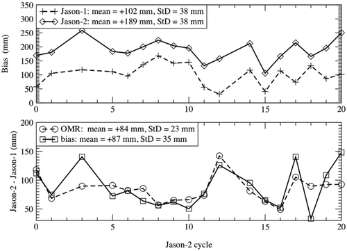
Figure 4 Jason-1 and 2 absolute and relative biases for the 18 common cycles (StD for Standard Deviation and OMR for orbit-range).
*σ is the standard deviation and N the number of cycles used.