In recent years, Historical Methods has published several articles which demonstrate the importance of developing historic environmental data to create benchmarks for understanding the climate and nature crisis. Recent examples include:
Eugene Costello, Kevin Kearney & Benjamin Gearey (2023), “Adapting to the Little Ice Age in pastoral regions: An interdisciplinary approach to climate history in north-west Europe,” Historical Methods: A Journal of Quantitative and Interdisciplinary History 56 (2):77–96. doi: 10.1080/01615440.2022.2156958.
Renée Sieber & Victoria Slonosky (2019), “Developing a Flexible Platform for Crowdsourcing Historical Weather Records,” Historical Methods: A Journal of Quantitative and Interdisciplinary History, 52 (3):164–177. doi: 10.1080/01615440.2018.1558138.
Péter Szabó, Silvie Suchánková, Lucie Křížová, Martin Kotačka, Martina Kvardová, Martin Macek, Jana Müllerová & Rudolf Brázdil (2018), “More than trees: The challenges of creating a geodatabase to capture the complexity of forest history,” Historical Methods: A Journal of Quantitative and Interdisciplinary History, 51 (3):175–189. doi: 10.1080/01615440.2018.1444523.
Consequently, the coeditors of Historical Methods welcome the opportunity to publish the editorial “Time to treat the climate and nature crisis as one indivisible global health emergency" which has been prepared for the United Nations Climate Change Conference (COP28).
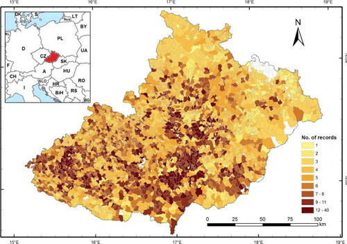
Figure 1. This map appeared in Péter Szabó, Silvie Suchánková, Lucie Křížová, Martin Kotačka, Martina Kvardová, Martin Macek, Jana Müllerová & Rudolf Brázdil (2018), “More than trees: The challenges of creating a geodatabase to capture the complexity of forest history,” Historical Methods: A Journal of Quantitative and Interdisciplinary History, 51 (3): 175–189. doi: 10.1080/01615440.2018.1444523. Included as Figure 3, this map shows the distribution and density of records (township-level) in the LONGWOOD database featured in this article. The inset shows the position of the study region in central Europe. The small area in the north without any records was added to Czechoslovakia in 1920, therefore archival sources prior to this date are absent.