
Abstract
Problem, research strategy, and findings: The fate of archaeological sites in cities, towns, and county jurisdictions are greatly affected by the decisions of local governments and planning departments, which usually operate with little formal guidance regarding archaeological site stewardship. What strategies do local governments use to effectively manage archaeological sites in their jurisdictions? Which ones work best? To address these questions, we carried out an exploratory study of mechanisms used by local government planners for archaeological resource protection in 24 states between 2008 and 2015, obtaining information from 69 local governments. We use questionnaires and interviews with local government staff, Tribal Historic Preservation Officers (THPOs), and State Historic Preservation Officers (SHPOs), identifying the range of practices employed. Within the jurisdictions we studied, the most elaborate programs a) have local ordinances protecting archaeology, on-staff archaeologists, and use special archaeological districts and zoning overlays, survey, and development guidelines linked to archaeological site probability models; b) maintain cost-saving partnerships with SHPOs, THPOs, universities, and local nonprofit heritage organizations; c) or use a combination of these practices.
Takeaway for practice: Virtually all local governments possess archaeological resources and an archaeological heritage worthy of protection. Local site preservation is most effective when it moves from project-based compliance to become an integral part of the overall planning process. By protecting these places and educating the public regarding their importance, local governments help to bolster local economies, local pride, and local amenities in a way that benefits residents, tourists, and generations to come.
Archaeological or "belowground" cultural resources provide unparalleled links to the human past. Like "aboveground" heritage sites such as historic buildings or districts, archaeological sites embody a community's history, and can serve as tools for civic engagement, bolstering community identity and supporting economic and educational efforts (e.g., Appler, Citation2012, Citation2013; Cressey, Reeder, & Bryson, Citation2003; Hoffman, Kwas, & Silverman, Citation2002; Little, Citation2002, Citation2012; McManamon, Citation2002). Protection and management of archaeological resources fall under a similar legal framework as that of built-environment heritage protections, drawing on a complex array of federal and state laws. State Historic Preservation Officers (SHPOs) provide oversight for managing archaeology in federal and state permitting, but most development in the United States is private, and sites affected by private development or local governments themselves are not protected by federal and state regulations for the most part. Unless local governments have policies in place to identify and protect archaeological sites, the heritage represented by such sites can be lost to development before a community even knows what it is losing (Cushman, Citation1998). Thus the fate of archaeological sites in cities, towns, and county jurisdictions affected by private or local jurisdiction development lies in the hands of local governments and planning departments, which operate with little formal guidance regarding archaeological site stewardship. What strategies do local governments use to effectively manage archaeological sites in their jurisdictions? Which strategies are most effective? How can they improve?
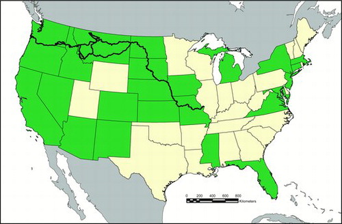
To address these questions, we carried out the first-of-its-kind systematic study of local government archaeological resource protection planning in 24 states from 2008 to 2015, as shown in . Our original project, funded by the National Park Service (NPS) through a Cooperative Ecosystem Studies Unit agreement with Portland State University, was linked to efforts by the NPS to understand policies of local governments located along the Lewis and Clark National Historic Trail and other NPS-managed historic trails in the United States. To place this documentation in a broader context, we solicited information from additional states that have one or more established local government programs or protocols for archaeological site protection. We used questionnaires and interviews with local government staff, Tribal Historic Preservation Officers (THPOs), and SHPOs, identifying the range of practices in place.
Figure 1. Map of United States (excluding Alaska/Hawaii) showing Lewis and Clark Trail and states (shaded) included in study. (Figure drafted by Justin Junge.)
In most cases, local governments lack formal procedures for documenting or protecting archaeological resources. They defer to federal or state agencies, providing development applicants with lists of federal or state archaeological laws, sometimes directing them to SHPOs. In many cases, local governments have innovated, developing a variety of mechanisms to manage such resources in response to heritage protection mandates. The most elaborate programs use special archaeological districts and zoning overlays as well as survey and development guidelines linked to archaeological site probability models, employ a staff archaeologist, have strong partnerships with SHPOs and THPOs, or use a combination of these practices. A few have developed enduring partnerships with universities, tribes, or private firms that provide local governments with technical assistance. Our ultimate purpose is to highlight ways that local governments can develop or enhance archaeological site protection programs, drawing from the experiences of local governments who currently maintain such programs.
Background
Archaeology is the study of the human past through the systematic recovery and analysis of material remains (Kelly & Thomas, Citation2013). As a science, archaeology generates knowledge on the full range of human technological, social, and cultural behavior over the past 2.5 million years, grappling with fundamental questions about our biological and cultural evolution. Archaeology also provides tangible links to the past (real places, real events, real people) that local communities, including modern descendants, can commemorate. "Knowing about these places and having a sense of what happened at them provide an important temporal context for modern life" (McManamon, Citation2002, p. 32). The value of archaeology in linking place, memory, and commemoration was highlighted recently by excavation along the waterfront in downtown St. Louis (MO), which uncovered the first physical evidence of the 1760s French colonial era and founding of the city. Most locals had assumed that all vestiges of colonial St. Louis were completely gone. Remarkably, the discovery coincided with the 250-year anniversary of the city's founding, giving the city "something new to embrace" (Heur, Citation2014). That it helps satisfy our intellectual and personal curiosity about our past contributes significantly to the public's support for archaeology.
Reflecting these values, the U.S. government has enacted a series of laws over the past 100 years to protect archaeological heritage (King, Citation2013). The Antiquities Act of 1906 was the first federal law to protect archaeological sites on federal land, punishing violations and giving the government authority to create national monuments. The cornerstone legislation supporting heritage protection is the National Historic Preservation Act (NHPA, P.L.89-665), initially passed in 1966 with amendments made in 1980 (P.L. 96-515). Section 106 lies at the core of the law, requiring that any federal or federally assisted undertaking account for effects on sites, districts, or buildings included in, or eligible for inclusion in, the National Register of Historic Places, which includes those "that have yielded, or may be likely to yield, information important in prehistory or history." To support the Section 106 process, provisions of NHPA established the a) National Register of Historic Places, b) the office and duties of the SHPOs in each state, c) a program of matching grants to support SHPO activities, d) the Certified Local Government (CLG) Program identifying local communities that meet preservation standards so they can take more autonomous responsibility for site preservation, and e) a national advisory council designed to oversee adherence to the Section 106 process (Smith, Citation1995). The Archaeological Resources Protection Act of 1979 expanded considerably on earlier laws, developing a permitting process to regulate excavation on federal or Indian lands. Furthermore, it substantially increased penalties for damage of archaeological resources. The passage of the Native American Graves Protection and Repatriation Act in 1990 completed this core set of federal laws, placing limits on the removal or retention of Native American human remains, funerary objects, and "objects of cultural patrimony" encountered archaeologically (King, Citation2013). These federal and state laws are all accessible online.Footnote1
At the state level, the creation of SHPOs following the 1966 passage of the NHPA helped formalize an apparatus for organizing archaeological data and enforcing archaeological protection laws. Many states then enacted archaeological protection laws that evolved in tandem with the federal laws. Like the federal laws, state laws had specific jurisdictional limits, focusing largely on the protection of archaeological resources on state lands, or during activities addressed in state permits.
The role of local governments in archaeological site protection in their own jurisdiction has never been articulated by federal policy, and is seldom articulated by state policies. What kinds of "planning for archaeology" take place at the local level? Before our study, we were familiar with the extreme ends of the spectrum. On one end are exemplary local governments such as the City of Alexandria (VA; Citation2014), City of St. Augustine (FL; Citation2014), and City of Phoenix (AZ; Citation2015) archaeology programs that have well-articulated planning processes for mitigating loss of cultural heritage in the face of urban development resulting from federal, state, or private undertakings. Moreover, these cities highlight how archaeology can be used to promote civic engagement, volunteerism, and heritage tourism (Appler, Citation2012, Citation2013; Cressey et al., Citation2003; Goddard, Citation2002; Little, Citation2002, Citation2012). Archaeology has been fundamental to creating public amenities such as museums, open spaces, art installations, transportation enhancements, and heritage walking and cycling trails (Appler, Citation2012), and providing opportunities for communities to tackle hard questions of racism and economic inequality (Cressey et al., Citation2003; Yamin, Citation2008).
On the other end of the spectrum are highly publicized cases of development harming urban archaeological sites, typically not because of failings in local government planning, but because of a breakdown in federal and/or state policy or practice (Stapp & Longenecker, Citation2009). Arguably the most extreme example occurred during the early 1990s construction of a U.S. General Services Administration (GSA) Building in lower Manhattan, New York City (NY). Archaeologists from a cultural resources management firm, hired by GSA to assist with the Section 106 process, discovered more than 400 sets of remains of free and enslaved Africans buried in the 18th century under about 8 feet of fill at the construction site (Harrington, Citation1993; Statistical Research, Inc., Citation2009). Similarly, expansion of Sacramento (CA) City Hall in 2003 revealed a Native American village with 45 sets of human remains (Praetzellis, Citation2009). In 2004, a large-scale multiagency transportation construction project in Port Angeles (WA) inadvertently uncovered more than 300 sets of human remains associated with a large Lower Elwha Klallam village (Mapes, Citation2009; Stapp & Longenecker, Citation2009).
These unanticipated discoveries had huge financial and social costs. Projects were delayed for months to years, and in some cases were completely shut down or redesigned. Construction costs increased (approximately $80 million for the NYC African Burial Ground [King, Citation2009]; $6 million for Sacramento [Praetzellis, Citation2009]; $60 million and counting for Port Angeles [Stapp & Longenecker, Citation2009]). Projects were marked by widespread, acrimonious public protests and negative publicity (LaRoche & Blakey, Citation1997; Mapes, Citation2009). African American and Native American communities with ancestral ties to the burials publicly expressed anger and a sense of disenfranchisement (LaRoche & Blakey, Citation1997; Mapes, Citation2009; Statistical Research, Inc., Citation2009).
These events had complex origins. Project oversight and regulation occurred at the state and federal levels, and local planners had little control over archaeological considerations, especially at New York City and Port Angeles. Greater local involvement, including bringing city planners and other stakeholders to the table in the planning process, arguably may have reduced the scale of the effects. Certainly problems like these have the greatest impacts locally: The effects on local economies and employment as well as the negative publicity and increased cynicism with government process can endure for some time. Given such high stakes, local governments have incentives to play a more active role in local cultural resource protection.
One key reason for these mistakes is that the projects were fast-tracked, with limited preconstruction archaeological assessment or consultation with stakeholders that might have shared their knowledge of the site or concerns about the project (King, Citation2009). Decision makers may have justified the fast pace because projects were located in highly modified, urbanized landscapes, proceeding from the mistaken assumption that centuries of development had obliterated intact archaeological deposits. Most people seem to have a blind spot regarding the risk of encountering archaeological remains under parking lots or beneath meters of fill, despite numerous examples to the contrary.
In short, as we began our project, we were aware of the benefits of good planning, accounting for archaeology, and the risks associated with little to no local government involvement. Given the important role local governments can have in managing archaeological resources, it is useful to move beyond extreme cases, and to review current practices used by local governments across the United States for the benefit of local governments exploring options for heritage management.
Research Strategy, Methodology, and Data
Between 2008 and 2011, we developed a two-phase protocol for exploratory analysis of local government archaeological heritage programs. First, we wanted to determine which local governments in the country had developed archaeological site protection programs. We made inquiries with appropriate individuals, starting with archaeological program directors with SHPOs, the state offices that oversee archaeological protections within states and generally track, and consult with, all local governments that integrate archaeological protections into their planning. With the aid of these initial contacts regarding the identity of known local government programs, we then used "snowball sampling" to identify any additional cases unknown to SHPOs and other initial contacts, following up with all individuals and agencies recommended by those initial contacts, and continuing this process until all additional recommendations were redundant and the pool of named local governments was exhausted. Specifically, we solicited this information largely through of the following venues:
communications with all SHPOs in the 10 states located along the length of the Lewis and Clark National Historic Trail, shown in ;
communications with SHPOs in 14 states not located along the length of the Trail;
communications with the Government Affairs Committee of the Society for American Archaeology;
postings to the listserv of the American Cultural Resources Association;
direct communications with attendees of the 73rd (2008) and 74th (2009) Annual Conferences of the Society for American Archaeology, the 62nd Annual Northwest Anthropological Conference, and the 2008 Cultural Resource Planning Summit; and
communications with various tribal and federal representatives associated with archaeological protection efforts in states along the Lewis and Clark National Historic Trail.
In total, we identified 69 local government programs through this process for more detailed analysis.
The second phase, in 2010 and 2011, involved interviews—in person, by telephone, or by email—with at least one representative of every one of the 69 local governments identified as possessing archaeology protection programs in our earlier inquiries, except in a small number of cases where representatives could not be contacted. Interviewees were asked to identify archaeological site protection mechanisms used in their jurisdictions as well as to provide any additional information they wished on the genesis or efficacy of those mechanisms. Follow-up interviews with SHPO offices were carried out in 2015 to update records. In cases where personal interviews were not possible, we used brief questionnaires, asking local government representatives to report on these themes. In sum, we obtained information from the 24 states and 69 local governments shown in and
Table 1. U.S. local governments with archaeological site protection methods.
Substantive Findings
Results from interviews and questionnaires are summarized in and reviewed here.
Inform Public/Developer on Existence of Federal/State Laws
In the most limited approach, local governments present the public, as well as potential applicants for development permits, with a list of federal and state laws pertaining to archaeological resources. In a sizeable majority of jurisdictions that do address archaeological resources somehow within their planning process, this is the extent of their site protection efforts; this is so common that we did not enumerate these jurisdictions for the current study. Staff takes no direct responsibility for tracking or actively protecting archaeological sites, but explicitly note on development permit applications that applicants are responsible for upholding national and state laws pertaining to archaeological resources. Often, this information is accompanied by SHPO contact information, and much less commonly by printed copies of applicable laws. In some cases, local governments provide this information to the public, in addition to maintaining other archaeological resource protection measures, as outlined below.
Ordinances
Fifty-four of the 69 local governments studied have ordinances, as seen in , requiring that cultural resources are considered as a precondition to certain permitting activities, especially development permits involving ground disturbance. Most but not all of these cases mention archaeological resources as one of several categories of protected cultural resources, a category that can also include historic structures and other protected resources. Ordinances typically call for some level of site analysis prior to construction as part of a larger development permitting process. This may require a formal survey by a professional archaeologist prior to ground disturbance, special data retrieval, or avoidance procedures (such as development setbacks) for documented sites. Yet relatively few ordinances articulate specific steps for identifying, evaluating, or managing archaeological sites beyond noting survey and avoidance requirements. These steps are often left to the discretion of the professional archaeologist or are negotiated on a case-by-case basis. Examples of such ordinances are readily available online: Two examples of especially thorough archaeological protection ordinance language, for the communities of Alexandria (VA) and Camas (WA), are excellent starting points.Footnote2
Inadvertent discoveries of archaeological materials can still occur during the development process, in spite of efforts to predict and avoid such encounters. Thus, some ordinances require that trained archaeologists be on site to monitor construction activities in areas with a high probability of archaeological resources. Many ordinances also require that if archaeological resources are discovered, work must stop to allow an assessment of impacts. In some cases, especially where mandated by state law, the state archaeologist must then be contacted for guidance; in some cases, an independent professional archaeologist may provide guidance, often in consultation with the SHPO archaeologist. Based on their assessment of the scale and scope of impacts, work may be postponed to allow for data recovery, site stabilization, or in certain cases the revision or revocation of development permits.
Passing an ordinance is only the first step in archaeological site protection (McGrath, Citation1998); without a coordinated planning process that manifests the ordinance, archaeological sites can still be vulnerable during development. Compliance with ordinances is difficult to assess, partly due to limited staffing, and levels of enforcement and punishment for noncompliance apparently vary widely between jurisdictions (Bellantoni & Haase, Citation1998).
Surveys
Most local governments (65 of 69, or 94%) studied have carried out surveys of their communities’ cultural resources, commonly including archaeological resources, as seen in . These surveys follow multiple protocols, but some bear the imprint of National Register Program guidance (e.g., Derry, Jandl, Shull, & Thorman, Citation1977). Community- or district-scale archaeological surveys are precursors to most of the archaeological protection programs developed by local governments, as surveys are required to establish baseline data that might guide subsequent ordinances and protection measures. Survey results are typically shown on overlay maps or incorporated into a geographic information systems (GIS) layer that local government planners may consult when considering developments on particular properties. Because most archaeological resources are below the ground surface, even detailed preliminary surveys often miss sites. For this reason, surveys are typically not considered final, but remain active, incorporating new data as archaeological sites are discovered through survey or site disturbance. Surveys of specific properties are often required as a precursor for development, and most local governments with this requirement incorporate the results of property-specific surveys into a database of results for the larger jurisdiction, to facilitate future planning that includes the consideration of site locations.
Predictive Models
In collaboration with archaeological consultants, 22% of surveyed local governments have developed predictive models that establish likely locations of archaeological sites within their jurisdiction (). These models integrate some combination of existing archaeological survey data, topographic information, and data regarding site distribution drawn from such sources as historical documents, oral histories, and ethnographic reports. Predictive models are then used to create a map or GIS layer showing areas of varying probabilities for archaeological sites to support the planning process. These usually overlay tax lot maps, illuminating the distribution of affected properties. Using a GIS system or other mechanism, the tax lots within certain risk categories can be identified on a case-by-case basis within the tax lot record. In some cases, as discussed below, these lots are officially codified into special districts or overlays.
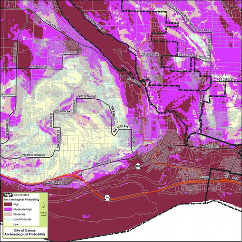
These models are often developed in partnership or under contract with a professional archaeological firm, a tribal cultural office or THPO, or a university department of anthropology. Predictive models allow communities to consider the probability of encountering archaeological resources early in the planning process without requiring comprehensive surveys of all affected areas. In some cases, predictive models have been used to develop or refine the geographical distribution of special archaeological zones, zoning overlays, or districts. To be effective as a predictor of site distribution and to withstand public scrutiny as a basis for heightened zoning restrictions, these models must be well substantiated and supported by a meaningful level of detail within survey data. Examples of maps produced from predictive models are shown for Alexandria (VA) in and Camas (WA) in
Figure 2. Archaeological probability model map for Alexandria, Virginia. (Version created in 1989 by Benjamin Skolnik and Francine Bromberg.)
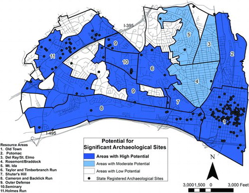
Figure 3. Archaeological probability model map for Camas, Washington. (Figure created by Bob Pool and Halina Lewandowski.)
Special Status for Sensitive Areas
In some communities, especially those with rich or widely known archaeological legacies, all properties are subject to the terms of a general archaeological ordinance and must, for example, undergo archaeological review before receiving development permits for ground-disturbing activities. More commonly, only properties believed to have a high probability of archaeological resources are held to this requirement. In turn, ordinances are linked to these areas of known or predicted concentrations of archaeological materials. These areas are mapped and often formally designated through zoning overlays or other special districts, receiving higher levels of scrutiny and site protection. As shown in , nine (13%) of the local governments formally assign special status to these so-called "sensitive areas." The configuration of special areas is generally established through the use of some combination of existing site location data (usually obtained from SHPOs), community-wide surveys, and predictive models regarding archaeological site distribution.
Typically, these overlays or districts are identified on a GIS layer or map that can be referenced by planning staff when considering development permit applications. These areas can be identified as part of a specific overlay, zone, or district, depending on the standards of the individual government agency. In a few cases, these areas are nominated as archaeological districts for listing in the National Register of Historic Places, and the district boundaries can serve as a de facto zone or zoning overlay with specific provisions for archaeological resources. Tax lot databases can also be organized to flag lots affected by the terms of a geographically delimited archaeological protection ordinance, ideally in ways that link seamlessly to permitting and other local government operations. When activities are permitted within the boundaries of these special areas, the local government typically will have requirements for managing archaeological resources that go beyond those applied to the rest of their jurisdiction. In most cases, ordinances specify that these special areas require archaeological survey and demonstrable efforts by development permit applicants to minimize or mitigate archaeological resource impacts as a precondition to any ground–disturbing activities.
Planning Staff Oversight: Access to State Records
In most local governments with archaeological resource protection programs, responsibility for site protection is assigned to a planning department and is integrated into general land use planning functions. Archaeological data are commonly integrated into the many other layers of information considered in permit application review, such as wetland inventories, flood hazard zones, slopes, and other biophysical data that may have a bearing on permitting a project. Local government staff assigned the task of reviewing development permit applications are generally involved in determining applications’ compatibility with ordinances and other protection tools relating to archaeological sites. In a few cases, especially in relatively large local governments, archaeological resource protection is assigned to a particular subdivision of the planning department that emphasizes certain protected resources, including cultural and historical sites. In other cases, a general planning director oversees archaeological resource protection as one of several resource categories considered when reviewing proposals and applications. These planners seldom have prior archaeological training, and by their own admission, learn much of what they know about archaeology on the job. Planners (as well as SHPO offices) often maintain lists of qualified consulting archaeologists in their area who private landowners can contact if existing ordinances, surveys, predictive models, and other materials indicate a detailed site survey is warranted.
As highlighted in Table 2, in a majority of states surveyed, archaeological site records (location, antiquity, context, history of research) are maintained by the SHPO, and are not shared with local governments unless they have a staff person who meets Secretary of the Interior's Standards for Archaeology (NPS, n.d.). Restricted access reflects the long history of site looting and concerns that unrestricted access to sensitive site information might contribute to heritage destruction. Yet without detailed information on the location, extent, and significance of archaeological resources, local governments clearly face challenges in the management of such resources. Three SHPO representatives we interviewed note that tribes in their area were concerned about sharing records with local governments that did not meet federal standards. Of the 24 states we contacted, seven listed in Table 2 have a more liberal policy of data sharing, allowing records to be sent to local municipalities, where local users are required to sign detailed agreements related to security and data use.Footnote3 In support of greater data sharing, a Washington SHPO representative noted, "We're losing more sites to bulldozers than to looting" (A. Brooks, personal communication, July 2015). The archaeological data manager for the Virginia SHPO explained, "In many cases, serious relic hunters know where sites are and don't need site databases to locate them. Careful sharing of site records with local governments can do more good than withholding that information" (J. Smith, personal communication, June 2015). For states that do not share detailed archaeological site records with local governments, state records managers usually assist local governments on a project basis when questions arise about whether a given property slated for development has a known site. Several states provide generalized site location maps in digital form or for online access (e.g., Maryland, New York, Iowa, and New Jersey) that provide basic facts about the archaeological resources in a particular area while being general about specific site locations. Several interviewed SHPO staff note that local governments rarely ask for site information. Staff note that if local governments showed more interest, SHPOs might develop a policy for sharing.
Staff Archaeologists
A total of 19 (28%) local governments surveyed have archaeologists on staff, usually a single individual, as seen in . Staff archaeologists oversee the documentation and management of archaeological resources, review permit applications for developments that could affect archaeological resources, carry out archaeological surveys and other fieldwork, manage private archaeologists contracted by the local government or private landowners, and take the lead in developing public outreach programs.
Staff positions tend to exist where there is financial and political will due to the size of the jurisdiction, the visibility or sensitivity of archaeological resources, or the economic role of cultural and historical tourism. For some, the catalyst has been enforcement actions including −lawsuits against local governments for noncompliance with state or federal laws. Discovery of a series of Native American burials during a city redevelopment project in Oak Harbor (WA), for example, led the city to hire a staff archaeologist to oversee compliance (Burnett, Citation2011). In some cases, archaeologists are regular paid government staff, while in other cases they work on contract, regularly or intermittently. In Wichita (KS), a local university graduate student fulfills the duty of a city archaeologist. Local government staff sometimes express a desire to add a staff archaeologist, but note a lack of resources or political support.
In addition to guiding planning tasks and sometimes complex regulatory processes relating to archaeological resources, staff archaeologists have helped lead a range of community projects and activities (Appler, Citation2012, Citation2013; Cressey et al., Citation2003). Such projects not only foster an appreciation for a community's archaeological heritage, but often increase public support for local government preservation programs. City archaeology programs in Alexandria and St. Augustine collaborate with avocational archaeological organizations, whose trained members volunteer in excavation, laboratory, and archival research; staff museums; and in developing education programs. Building a community of volunteers and strong outreach programs helps mitigate the need for enforcement while promoting civic engagement. City archaeologists also work with local museums, which often serve as repositories for locally generated archaeological collections (Phoenix, St. Augustine, Alexandria).
Special Resource Protection Programs and Partnerships
In addition to the archaeological resource protection components outlined above, our sources describe various partnerships and other programs fundamental to their archaeological protection programs, which we review in turn.
Historic Preservation Commissions
These have a long history in the United States, representing community groups that arose—often from grassroots efforts—to address concerns about the loss of local heritage, especially of the built environment. Members are generally not paid. They represent topical specialists (e.g., architects, historians) and interested citizens, often appointed by elected city officials. Commissions meet regularly to assess cultural resource matters within a defined jurisdiction, assisting local governments in documenting properties of historical and cultural significance, identifying and nominating properties for listing in the National Register as part of historical districts, and, at times, playing a role in the review of applications potentially affecting these properties. Most commissions focus on historic structures. Archaeologists are sometimes included on these commissions, occasionally as part of a local government's response to legal mandates, but more often because of local idiosyncrasies such as the presence of high-profile archaeological resources or the involvement of particular individuals with archaeological interests.
Massachusetts has a widely recognized program of local historic commissions (LHCs) that maintain inventories of historic and archaeological properties and advise local governments about preservation issues. As noted in , 10 of these incorporate archaeology into city planning. The state works closely with LHCs to help secure local grants, support community outreach, and encourage volunteerism (Simon & Bell, Citation1998; E. Bell, personal communication, June 2015).
CLGs
shows that 48 of the 69 local governments we contacted are in the CLG program, which was created in 1980 as part of amendments to the NHPA. Funded by the NPS's National Register program and administered by the SHPO offices, the CLG program was created to link federal, state, and local governments into a partnership to preserve local heritage. To acquire and maintain CLG status, the community must have a preservation commission, but as shown in , not all communities with preservation commissions have become CLGs. Besides the commission, CLGs maintain an up-to-date database of cultural resources and have a historic preservation ordinance, some of which address archaeological resources. By becoming a CLG, a local government gains access to grants and technical assistance from SHPOs. States are required to give 10% of their annual appropriation from the Federal Historic Preservation Fund to the grant program.
While CLG grants can be used to support archaeological documentation, protection, and education, most funds are directed to the built environment. For example, none of the 49 CLGs in Oregon has directed funds to archaeology since 2010 (K. Gill, personal communication, July 2015).Footnote4
Federal–Local Partnerships
In certain cases, federal cultural resource managers with archaeological expertise are available to support local governments’ site protection efforts. This is especially effective when cultural resource staff from a federal land-management agency are able to support multiple small communities that are both proximate to federally managed lands and share some of the same overarching management objectives as the federal agency.
Along the Lewis and Clark National Historic Trail, this model has been especially successful within the Columbia River Gorge National Scenic Area (CRGNSA) in Oregon and Washington. Communities within the CRGNSA share the same basic framework for archaeological site protection, including similar ordinances and planning mechanisms. U.S. Forest Service (USFS) staff support this integrated effort, maintaining a predictive model of archaeological site locations on both public and private lands within the scenic area, and maintaining a database of documented archaeological sites within participating communities. At the request of local governments, USFS archaeologists may participate in site surveys in these communities for large development proposals, while private archaeologists may be hired by private landowners for more conventional development applications. Elsewhere, archaeological site information is shared in both directions by particular local governments and federal staff, such as at Cannon Beach (OR), where NPS staff have provided technical assistance in the identification of site boundaries, integrity, and public interpretive options at a historic Nehalem-Tillamook village site visited by members of the Lewis and Clark expedition in the winter of 1806.
Tribal and THPO Partnerships
As sovereign political entities, federally recognized tribes throughout the United States increasingly advocate for a role in the management of archaeological and other cultural resources in their traditional areas of interest. American Indian tribes, Alaska Native communities and corporations, and Native Hawaiian organizations commonly have cultural offices or federally approved THPOs with the capacity to document archaeological resources and provide certain site management services. THPOs are funded and certified solely through a nationwide program of the NPS, which also provides THPOs with opportunities for training and technical assistance.Footnote5 THPOs function as a tribally managed equivalent of SHPOs within defined tribal areas of interest. In many instances (e.g., California, Oregon, South Dakota, Washington), THPOs provide information to local governments on a case-by-case basis regarding site locations, and provide archaeological monitors to be on site during ground-disturbing activities. They sometimes help facilitate the tribal consultation process for development, sharing tribal knowledge of and concerns about specific sites; in turn, this helps minimize adverse impacts on archaeological resources as well as financial costs to local governments and developers resulting from inadvertent discoveries or other unanticipated problems. When financial resources are available and site values match tribal interests, THPOs can also guide the acquisition of important archaeological sites or the development of conservation easements. For example, the Osage Nation recently acquired Sugar Loaf Mound, one of the last earthen mounds remaining in St. Louis (MO; Lourdes, Citation2009).
The scale and skills of tribal cultural offices vary considerably depending on their history, staff experience, and resources. In some exceptional cases, tribal cultural offices maintain large amounts of survey data, create predictive models, and establish partnerships with local governments to oversee many of the site protection functions outlined elsewhere in this study. The THPO for the Suquamish Tribe in western Washington, for example, built a predictive model incorporating survey data, topographic information, and cultural information from tribal oral histories, written references to tribal sites, historic maps, archival information, newspapers, and other lines of evidence. With this powerful tool, and a staff that includes professional archaeologists, the Suquamish Tribe has been able to assist multiple local governments in their area, providing technical support when planners consider potential archaeological site impacts or long-term planning for site management. Similar models have been used by tribes such as the Grande Ronde in western Oregon, which has developed a network of alliances with local governments, especially in the Willamette Valley region. While federally unrecognized tribes often lack the capacity to support cultural programs at this scale, some local governments regularly consult with these tribes to assess potential impacts of proposals on sites of known cultural and historical significance to these groups.
Site Ownership Programs/Conservation Easements
Local governments can preserve important archaeological sites in their jurisdiction by purchasing land on which the site resides or through preservation or conservation easementsFootnote6 (Appler, Citation2013; Simon, Citation1994). Purchased parcels of land such as in Alexandria (Fort Ward), Phoenix (South Mountain Park), and Pima County (AZ; Valencia) can be developed as parks and open spaces with interpretive facilities and sometimes ongoing archaeological projects in which the public can participate. Funds can be acquired through bonds, grants, and partnerships with tribes or nonprofit land conservancies. For example, in 2009, with funds from a county bond measure and Arizona State Parks, Pima County purchased the 67-acre Valencia archaeological site in Tucson (Pima County, Citation2015). The Archaeological Conservancy is a national nonprofit organization whose mission is to preserve important archaeological sites in the United States, mainly through acquisition of property—via purchasing or donations—but also through conservation easements (Archaeological Conservancy, Citation2014). The organization is particularly adept at developing multiparty agreements relating to long-term site protection. As of 2015, the conservancy had more than 485 properties in 43 states, including a few acquired in partnership with county and city governments (e.g., Sacramento; C. Wilkins, personal communication, June 2015).
Take-Home Lessons for Local Government Planning for Archaeology
Noteworthy archaeological sites found throughout the United States are eminently worthy of protection. Still, the vast majority of local U.S. governments lacks protocols for archaeological site preservation. In the absence of oversight, it is difficult to know how much of the archaeological record is lost through private- or public-sector development outside the state and federal regulatory systems. This is unfortunate given that archaeological sites are nonrenewable resources; once gone, they are gone forever. Fortunately, even in the absence of coherent guidance from state and federal agencies, a number of local governments have developed tools to support archaeological site protection.
This study is the first attempt to illuminate these tools. Through phone interviews and questionnaires, we obtained records from 69 municipalities in 24 states. The results suggest certain recurring strategies. Most local governments with archaeological protection programs have commissioned archaeological surveys, or require smaller-scale surveys as a prerequisite for development permitting. Surveys by professional archaeologists are required in some cases where archaeological resources are anticipated. Local governments sometimes maintain lists of qualified archaeologists (commonly developed by, or in cooperation with, SHPOs) that are distributed with permit applications, or identify university or tribal and THPO contacts who might assist. Using existing data or probability models, local governments have created zoning overlays or special districts; within these special areas of highly concentrated or anticipated archaeological resources, there are enhanced requirements for survey or restrictions on development due to the potential adverse effects of unguided development upon archaeological resources. The strongest programs have staff archaeologists who can provide leadership within the local government itself, guiding the permitting and regulatory processes and helping to build and maintain partnerships with federal and state agencies, tribes, and a range of community partners such as avocational groups, museums, and universities. Local governments lacking this expertise have entered into partnerships with entities that can aid in archaeological site management and interpretation, such as nearby federal agency staff, tribes, and nonprofit organizations.
Most local government representatives we contacted suggest a need for greater support, communication, and integration among state and federal agencies and local governments seeking to protect archaeological resources. Planners who manage archaeological resources voice concerns about their limited access to archaeological training and data. One approach that addresses these twin concerns has emerged in Washington recently, where representatives from government agencies, tribes, private companies, and local government planners assemble for the annual two-day Cultural Resource Protection Summit.Footnote7 This meeting provides a forum for all parties with interests in heritage preservation to meet, share ideas about best practices, and find common ground for better integration of cultural resource considerations into the planning process. Other states could emulate this and hold similar events.
Several interviewees note financial obstacles to developing a stronger local government archaeological site protection process. One issue is the cost of staffing and the regulatory process itself. Budgetary constraints on archaeological resource protection programs vary widely between communities. Partnerships with federal agencies, tribes, or other entities allow relatively small communities to have highly effective site protection programs without requiring large budgets. The second issue noted is the potential adverse economic impacts of archaeological resource regulations, especially because regulation could delay development and require design modification. Providing incentives for compliance and reporting, such as tax exemptions, sometimes offsets private landowners’ concerns about financial burden of archaeological protection. Effective integration of cultural resources into local government planning has the obvious advantage of reducing project delays and reducing chances of punitive fines.
Yet planning that accounts for archaeology, using whichever tools a local government can support, and linking site protection to public education and outreach, produces tangible economic, social, and educational rewards (Hoffman et al., Citation2002). Most people are fascinated by archaeology but think they need to travel to exotic places to experience it. Local governments, joining with partners possessing expertise in archaeology and heritage, can build on this ready-made interest. By protecting these places "in our own backyard," and educating the public regarding their sensitivity and importance, local governments help to bolster local economies and local civic pride in ways that benefits residents and visitors for generations to come. We hope the examples highlighted here of planning programs that protect archaeological resources provide guidance for other local governments nationwide as they seek to achieve these multiple goals.
Research Support
This research was funded under two NPS Cooperative Ecosystem Studies Unit Task Agreements between Lewis and Clark National Historic Trail and Portland State University, carried out under cooperative agreement H8W07060001.
Acknowledgments
The authors thank Jennifer Minner and Michael Holleran for organizing this special issue and the three peer reviewers, whose detailed comments greatly improved this manuscript. Wendy Ann Wright's contribution to the project (interviewing sources, compiling records) is much appreciated. The authors also thank all the staff from federal, state, local, and tribal governments who shared their practices and ideas, especially Ed Bell, Stephenie Kramer, Allyson Brooks, Ken Reid, Jenan Saunders, Jim Cogswell, Dean Anderson, Jennifer Chadwick, Brian Jones, Nancy Herder, Jim Woodrick, Eman Vovsi, Mike Runge, Jolene Smith, Katherine Marcopul, Kate Hampton, Judith Deel, Dennis Griffin, Chris Curran, Kuri Gill, Dave Harrelson, Eirik Thorsgard, Richard Basch, Kevin Cupples, Rainmar Bartl, and Dennis Lewarch. We accept all errors herein as our own.
Additional information
Notes on contributors
Douglas Deur
Douglas Deur ([email protected]) is a research faculty member in the Department of Anthropology at Portland State University focusing on cultural uses of public lands and resources.
Virginia L. Butler
Virginia L. Butler ([email protected]) is an archaeological research scientist and educator in the Department of Anthropology at Portland State University.
Notes
1 State laws may be obtained directly from the SHPO for each state via http://www.nps.gov/nr/shpolist.htm. For full text of federal laws, see http://www.nps.gov/history/laws.htm.
2 For Camas archaeological ordinances, see http://camas.granicus.com/DocumentViewer.php?file=camas_e30aa03e6c142d3b35450d46b10f4d40.pdf; for Alexandria archaeological ordinance and maps, see http://www.alexandriava.gov/historic/archaeology/default.aspx?id=39208#protectioncode
3 To address concerns local governments had about assuming control of archaeological site records given public disclosure laws, in 2006, the State of Washington passed RCW 42.56.300, which exempts archaeological sites and traditional cultural properties from disclosure laws (http://apps.leg.wa.gov/rcw/default.aspx?cite=42.56.300).
4 Oregon has 49 CLGs as of July 2015, but because one to two communities become CLGs each year, the number of programs in 2010 was probably between 40 and 45.
5 For more information on the THPO program, see http://www.nps.gov/thpo/index.html
6 Preservation easements are voluntary legal agreements between a property owner and a qualified organization or government agency that protects cultural resources (buildings, archaeological sites) from activities that would harm the property's integrity (see http://www.preservationnation.org/information-center/law-and-policy/legal-resources/easements/#.VaNamRNViko). Easements provide assurances that a property's historical or archaeological values will be maintained by subsequent owners. Property owners gain a tax benefit from the reduction in monetary value that result from the restriction in land use, and are sometimes compensated monetarily by a jurisdiction or partnering nonprofit that purchases the easement from the landowner. While preservation easements are common nationwide, their use for archaeology is relatively rare. For further information on two noteworthy programs, see Archaeology Southwest (http://www.archaeologysouthwest.org/what-we-do/initiatives/protection/) and Division of Historical Resources for the State of Florida (http://dos.myflorida.com/media/30910/easement.pdf).
7 For additional information on the Culture Resource Protection Summit, see http://www.theleadershipseries.info/summithome.html
References
- Appler, D. R. (2012). Municipal archaeology programs and the creation of community amenities. The Public Historian, 34(3), 40–67.
- Appler, D. R. (2013). Tracing the roots of municipal archaeology in St. Augustine, Florida: The story of how the "oldest city" connected archaeology, local government, and the public. Public Archaeology, 12(1), 7–26. doi:10.1179/1465518713Z.00000000025
- Archaeological Conservancy. (2014). About us. Retrieved from http://www.archaeologicalconservancy.org/about-us/
- Bellantoni, N. F., & Haase, W.R. (1998). Planning and zoning strategies: Protecting Connecticut's archaeological resources. CRM, 21(10), 9–11. Retrieved from http://www.nps.gov/history/CRMJournal/CRM/v21n10.pdf
- Burnett, J. (2011, August 27). Most Oak Harbor officials knew about archaeological site before project started. Whidbey News-Times. Retrieved from http://www.whidbeynewstimes.com/news/128489998.html
- City of Alexandria. (2014, December 16). Archaeology and preservation in Alexandria, Virginia. Retrieved from http://alexandriava.gov/historic/archaeology/?id=39208
- City of St. Augustine. (2014, December 16). Archaeology program. Retrieved from http://www.digstaug.org/program.cfm
- City of Phoenix. (2015, July 13). City archaeology. Retrieved from https://www.phoenix.gov/parks/arts-culture-history/pueblo-grande/city-archaeology
- Cressey, P. J., Reeder, R., & Bryson, J. (2003). Held in trust: Community archaeology in Alexandria, Virginia. In L. Derry & M. Molloy (Eds.), Archaeologists and local communities: partners in exploring the past (pp. 1–17). Washington, DC: Society for American Archaeology.
- Cushman, D. W. (1998). Public archaeology and local land use law. CRM, 21(10), 4. Retrieved from http://www.nps.gov/history/CRMJournal/CRM/v21n10.pdf
- Derry, A., Jandl, H. W., Shull, C. D., & Thorman, J. (1977). Guidelines for local surveys: A basis for preservation planning. National Register Bulletin, 24. Retrieved from: http://www.nps.gov/nr/publications/bulletins/nrb24/nrb24.pdf
- Goddard, T. (2002). Potsherds and politics. In B. L. Little (Ed.), Public benefits of archaeology (pp. 208–218). Gainesville, FL: University Press of Florida.
- Harrington, S. P. M. (1993, March/April). Bones and bureaucrats: New York's great cemetery imbroglio. Archaeology Magazine. Retrieved from http://archive.archaeology.org/online/features/afrburial/
- Heur, A. (2014, April 2). Scientists discover remnants of St. Louis’ French colonial past. National Public Radio. Retrieved from http://www.npr.org/2014/04/02/298159486/st-louis-unearths-some-surprises
- Hoffman, T. L., Kwas, M. L., & Silverman, H. (2002, March). Heritage tourism and public archaeology. The SAA Archaeological Record, 30–32.
- Kelly, R. L., & Thomas, D. H. (2013). Archaeology (6th ed.). Boston, MA: Cengage Learning.
- King, T. F. (2009). Disaster on Broadway: The African burial ground. In D. C. Stapp & J. G. Longenecker (Eds.), Avoiding archaeological disasters: A risk management approach (pp. 94–96). Walnut Creek, CA: Left Coast Press.
- King, T. F. (2013). Cultural resource laws and practice: An introductory guide (4th ed.). Walnut Creek, CA: AltaMira Press.
- LaRoche, C. J., & Blakey, M.L. (1997). Seizing intellectual power: The dialogue at the New York African Burial Ground. Historical Archaeology, 31(3), 84–106.
- Little, B. J. (Ed). (2002). Public benefits of archaeology. Gainesville, FL: University Press of Florida.
- Little, B. J. (2012). Public benefits of public archaeology. In R. Skeates, C. McDavid, & J. Carman (Eds.), The Oxford handbook of public archaeology (pp. 395–413). Oxford, UK: Oxford University Press.
- Lourdes, M. (2009, August 1). Osage tribe purchases historic St. Louis mound. St. Louis Post-Dispatch. Retrieved from http://www.stltoday.com/osage-tribe-purchases-historic-st-louis-mound/article_0e368c53-220b-5678-abb7-5766af6916ec.html
- Mapes, L. V. (2009). Breaking ground: The Lower Elwha Klallam Tribe and the unearthing of Tse-whit-zen Village. Seattle, WA: University of Washington Press.
- McGrath, K. C. (1998). Passing the ordinance is not enough: Two examples from Iowa. CRM, 21(10), 15–17. Retrieved from http://www.nps.gov/history/CRMJournal/CRM/v21n10.pdf
- McManamon, F. P. (2002). Heritage, history, and archaeological educators. In B. L. Little (Ed.), Public benefits of archaeology (pp. 31–45). Gainesville: University Press of Florida.
- National Park Service. (n.d.). Archaeology and historic preservation: Secretary of the Interior's standards and guidelines [as amended and annotated], professional qualifications and standards. Retrieved from http://www.nps.gov/history/local-law/arch_stnds_9.htm
- Pima County. (2015). Office of Sustainability and Conservation, Cultural Resources & Historic Preservation Division. Retrieved from http://www.pima.gov/cmo/admin/reports/ConservationReport/PDF/Chapters/Cultural/Valencia%20Archaeological%20Site.pdf
- Praetzellis, A. (2009). Afterward: Sacramento City Hall expansion project: Another inconvenient truth. In D. C. Stapp & J. G. Longenecker (Eds.), Avoiding archaeological disasters: A risk management approach (p. 121). Walnut Creek, CA: Left Coast Press.
- Simon, B. G. (1994). The carrot, not the stick: Strategies for protecting archaeological sites on private property. In J. E. Kerber (Ed.), Cultural resources management: Archaeological research, preservation planning, and public education in the Northeastern United States (pp. 191–208). Westport, CT: Bergin & Garvey.
- Simon, B. G., & Bell, E. L. (1998). Community archaeology: Working with local governments. CRM, 21(10), 5–8. Retrieved from http://www.nps.gov/history/CRMJournal/CRM/v21n10.pdf
- Smith, K. C. (1995). High points in historic preservation. Archaeology and Public Education, 5, 10–11.
- Stapp, D. C., & Longenecker, J. G. (2009). Avoiding archaeological disasters: A risk management approach. Walnut Creek, CA: Left Coast Press.
- Statistical Research, Inc. (2009). The skeletal biology, archaeology, and history of the New York African burial ground: A synthesis of volumes 1, 2, and 3: New York African burial ground, Vol. 4. Washington, DC: Howard University Press and U.S. General Services Administration. Retrieved from: http://www.gsa.gov/largedocs/ABG-SYNTHESIS.pdf
- Yamin, R. (2008). Digging in the city of brotherly love: Stories from Philadelphia archaeology. New Haven, CT: Yale University Press.